Embed Size (px)
Citation preview


TAZMAC Reroute Tazewell-Faraday-Bearwallow 138kV Transmission Line
Tazewell and Buchanan Counties, Virginia
August 15, 2014 Patty Trocki Natural Resource Group 80 S 8th Street 1000 IDS Center Minneapolis, MC 55402 RE: Tazewell-Bearwallow Reroute
Tazewell-Buchanan Area 138kV Transmission Improvement Project Tazewell and Buchanan Counties, Virginia
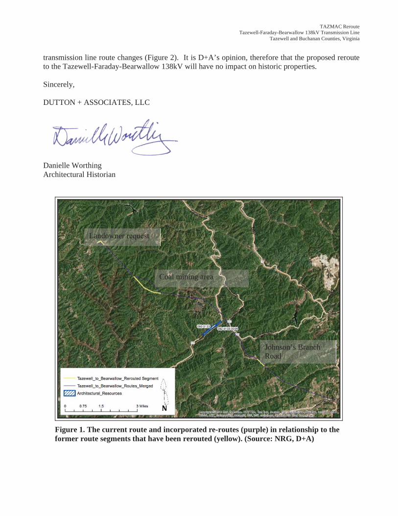
Mrs. Trocki, In March 2014, Dutton + Associates conducted a Pre-Application Analysis of the Tazewell-Buchanan Area 128kV Transmission Improvements Project in Tazewell and Buchanan Counties, Virginia and McDowell County, West Virginia. The analysis was performed for Natural Resource Group, LLC (NRG), who is assisting Appalachian Power Company (APco) in support of a State Corporation Commission application. The analysis was completed in accordance with Virginia Department of Historic Resources’ (VDHR) guidance titled “Guidelines for Assessing Impacts of Proposed Electric Transmission Lines and Associated Facilities on Historic Resources in the Commonwealth of Virginia” (January 2008) and supplements a preliminary report prepared by NRG (February 2014). This letter addresses three subsequent re-routes that ha been made on the Tazewell-Faraday-Bearwallow 138kV Transmission Line. From north to south, the re-routes include a landowner Bearwallow, a
northwest of Faraday, and Johnson’s Branch Road (Figure 1). The background research conducted as part of this re-route analysis was designed to identify all previously recorded National Historic Landmarks (NHL) located within 1.5-miles of the proposed re-route’s right-of-way (ROW), all historic properties listed in the National Register of Historic Places (NRHP) located within 1.0-mile of the proposed re-route’s ROW, all historic properties considered eligible for listing in the NRHP located within 0.5-mile of the proposed ROW, and any archaeological sites located within the ROW. Historic properties include architectural resources, historic and cultural landscapes, battlefields, and historic districts. Review of VDHR records reveals that no previously recorded historic resources are located within 1.5-miles of the proposed
TAZMAC Reroute Tazewell-Faraday-Bearwallow 138kV Transmission Line
Tazewell and Buchanan Counties, Virginia
transmission line route changes (Figure 2). It is D+A’s opinion, therefore that the proposed reroute to the Tazewell-Faraday-Bearwallow 138kV will have no impact on historic properties.
Sincerely, DUTTON + ASSOCIATES, LLC
Danielle Worthing Architectural Historian
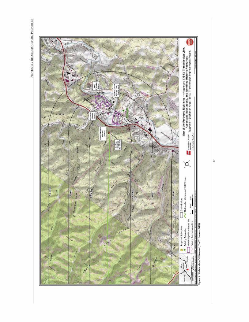
Figure 1. The current route and incorporated re-routes (purple) in relationship to the former route segments that have been rerouted (yellow). (Source: NRG, D+A)
Landowner
Coal mining area
Johnson’s Branch Road

TAZMAC Reroute Tazewell-Faraday-Bearwallow 138kV Transmission Line
Tazewell and Buchanan Counties, Virginia
Figure 2. Historic resources within 0.5-mile, 1.0-mile, and 1.5-miles of the re-routed segments . (Source: NRG, D+A)

Pre Application Analysis for Cultural Resources of theTazewell – Buchanan Area 138kV Transmission
Improvements Project
Tazewell and Buchanan Counties, Virginia
PREPARED FOR:
PREPARED BY:
PRINCIPAL INVESTIGATOR:
ARCHITECTURALHISTORIAN:
March 2014

i
ABSTRACT
Dutton + Associates, LLC (D+A) conducted a Pre-Application Analysis (analysis) of the Tazewell-Buchanan Area 138kV Transmission Improvements Project in Tazewell and Buchanan Counties, Virginia. The analysis was performed for Natural Resource Group, LLC (NRG), who is assisting Appalachian Power Company (APco) in support of a State Corporation Commission (SCC) application. The analysis was completed in accordance with Virginia Department of Historic Resources’ (VDHR) guidance titled “Guidelines for Assessing Impacts of Proposed Electric Transmission Lines and Associated Facilities on Historic Resources in the Commonwealth of Virginia” (January 2008) and supplements a preliminary report prepared by NRG (February 2014). This report only addresses those portions of the project that lie within the borders of the Commonwealth of Virginia.
The Richlands-Whitewood 138kV Transmission Line will involve the construction of a new single circuit line, a new Whitewood 138kV Switchyard, modifications to the Richlands Substation, and construction of the Whitewood 138kV Extension, which connects to the northern end of the line to the existing Grassy Creek-Hales Branch 138 kV Transmission Line. The project will also include upgrade of the Tazewell-Faraday-Bearwallow 138kV Transmission Line. APco plans to rebuild and upgrade approximately 12.3 miles of an existing 69kV line to 138kV, 8.6 miles of which are located in Tazewell County, Virginia, with the remainder in West Virginia. Improvements are to be made to the existing Tazewell and Bearwallow substations along this line.
The background research conducted as part of this analysis was designed to identify all previously recorded National Historic Landmarks (NHL) located within 1.5-miles of the proposed project’s right-of-way (ROW), all historic properties listed in the National Register of Historic Places (NRHP) located within 1-mile of the proposed project’s ROW, all historic properties considered eligible for listing in the NRHP located within 0.5-miles of the proposed project’s ROW and all buildings, structures, and archaeological sites located within the proposed project’s ROW. Historic properties include architectural and archaeological (terrestrial and underwater) resources, historic and cultural landscapes, battlefields, and historic districts. For each previously recorded NHL located within 1.5-miles of the proposed project’s ROW, each previously recorded historic property that is listed in the NRHP located within 1-mile of the proposed project’s ROW, and each previously recorded historic property that has been determined eligible for listing in the NRHP located within 0.5-miles of the proposed project’s ROW, and all properties located within the ROW, a review of existing documentation and a field reconnaissance was undertaken to assess each property’s significant character-defining features, as well as the character of its current setting. Following identification of historic properties, D+A assessed the potential for impacts to any identified properties as a result of the proposed project. Specific attention was given to determining whether or not upgrades of the proposed transmission line and its associated facilities could introduce new visual elements into the property’s viewshed or directly impact the property through construction, which would either directly or indirectly alter those qualities or characteristics that qualify the historic property for listing in the NRHP.

ii
There are no previously recorded NHL’s located within 1.5-miles of each proposed project’s ROW. There are two previously recorded historic districts (148-5020 and 148-5014) and one individual property (148-5018) listed on the NRHP within 1.0-mile of each proposed project’s ROW. There is one previously recorded historic district (092-5133) and one individual property (092-5133-0004) that are considered eligible for the listing in the NRHP located within 0.5 miles of each proposed project’s ROW. There are no previously recorded properties or archaeological sites located within or immediately adjacent to either proposed project’s ROW.
A summary of our findings is provided in the table below.
Potential Impacts Summary for Architectural Resources
Resource # Resource Name NationalRegister Status Potential Impact
Richlands-Whitewood 138kV Transmission Line
148-5020 Tazewell Avenue Historic District Listed None
148-5014 Richlands Historic District Listed None
148-5018 Williams House Listed None
Tazewell-Faraday-Bearwallow 138kV Transmission Line
092-5133 Amonate Coal Camp Historic District Eligible Minimal
092-5133-0004 Trinity Full Gospel Church Eligible Minimal to None

iii
TABLE OF CONTENTS
LIST OF FIGURES .................................................................................................................IIILIST OF TABLES ...................................................................................................................VLIST OF PLATES ...................................................................................................................VINTRODUCTION..............................................................................................................1PROJECTDESCRIPTION ...............................................................................................3RESEARCHDESIGN ........................................................................................................7
Methods....................................................................................................................................... 7Archival Research ....................................................................................................................... 7Field Reconnaissance .................................................................................................................. 7Assessment of Potential Impacts ................................................................................................ 8Report Preparation ...................................................................................................................... 8
PREVIOUSLYRECORDEDHISTORIC PROPERTIES ..............................................9WHITEWOOD 138 KVEXTENSION .............................................................................................. 19EXPECTED FIELDRECONNAISSANCE RESULTS ............................................................................... 19
RESULTSOF FIELDRECONNAISSANCE.................................................................21ASSESMENTOFPOTENTIAL IMPACTS .................................................................61REFERENCES.................................................................................................................65
LIST OF FIGURES
Figure 1. Improvement projects planned for Tazewell and Buchanan Counties. Source: NRG .... 4Figure 2. Structure diagram for improvements in Tazewell and Buchanan Counties. Source: NRG ................................................................................................................................................ 5Figure 3. Richlands to Whitewood, 1 of 2. Source: NRG ............................................................ 11Figure 4. Richlands to Whitewood, 2 of 2. Source: NRG ............................................................ 12Figure 5. Tazewell-Faraday-Bearwallow, 1 of 4 Source: NRG .................................................... 15Figure 6. Tazewell-Faraday-Bearwallow, 2 of 4 Source: NRG .................................................... 16Figure 7. Tazewell-Faraday-Bearwallow, 3 of 4 Source: NRG .................................................... 17Figure 8. Tazewell-Faraday-Bearwallow, 4 of 4 Source: NRG .................................................... 18Figure 9. Tazewell Avenue Historic District (green) in relationship to transmission line (existing transmission lines are depicted by yellow dotted lines and the proposed transmission line is depicted by the red dotted line), and locations and directions of plates. Base Map Source: V-CRIS 2014. .................................................................................................................................... 23Figure 10. Location and direction of each photo simulation in relationship to the proposed Richlands-Whitewood 138kV Transmission Line (red dotted line) and existing transmission lines (yellow dotted lines). (Note: The locations of new structures depicted on the overview map are approximate. The final locations are dependent upon the final design and the completion of ground survey.) ............................................................................................................................. 28Figure 11. Terrain in 3D view, facing northeast. Source: Terrain Navigator Pro. ....................... 28Figure 12. Line of site (blue line) from Tazewell Avenue Historic District towards structure Rich 2. First ridge obscures view towards proposed structures. Source: Terrain Navigator Pro. ......... 29

iv
Figure 13. Original image used for photo simulation, taken from corner of Fairfax Avenue and Second Street facing northeast, 0.45-miles from ROW. Red arrow points to existing Structure No. 105. ......................................................................................................................................... 29Figure 14. Viewshed will remain the same; photograph taken from corner of Fairfax Avenue and Second Street facing northeast, 0.45-miles from ROW. Red arrow points to existing Structure No. 105. ......................................................................................................................................... 30Figure 15. Original image used for photo simulation, taken from Tazewell Avenue between Second and Third Street facing east, 0.35-miles from ROW. ...................................................... 30Figure 16. Viewshed will remain the same; photograph taken from Tazewell Avenue between Second and Third Street facing east, 0.35-miles from ROW. Red arrow points to existing Structure No. 105. ......................................................................................................................... 31Figure 17. Richlands Historic District (green) in relationship to transmission line (existing transmission lines are depicted by yellow dotted lines and the proposed transmission line is depicted by the red dotted line), and locations and directions of plates. Base Map Source: V-CRIS 2014 ..................................................................................................................................... 33Figure 18. Location and direction of each photo simulation in relationship to the proposed Richlands-Whitewood 138kV Transmission Line (red dotted line) and existing transmission lines (yellow dotted lines). (Note: The locations of new structures depicted on the overview map are approximate. The final locations are dependent upon the final design and the completion of ground survey.) ............................................................................................................................. 40Figure 19. Terrain in 3D view, facing northwest. Source: Terrain Navigator Pro. ...................... 40Figure 20. Line of site (blue line) from Richlands Historic District towards Rich 2. The first ridge largely obscures view towards proposed structures from the majority of District. Source: Terrain Navigator Pro. ............................................................................................................................... 41Figure 21. Original image used for photo simulation, taken from Lee Street at Grayson Avenue facing northwest, 0.85-miles from ROW. Red arrow points to existing structure. ...................... 41Figure 22. Viewshed will remain the same; photograph taken from Lee Street at Grayson Avenue facing northwest, 0-85-miles from ROW. Red arrow points to existing Structure No. 105. ....... 42Figure 23. Williams House (green) in relationship to ROW (existing transmission lines are depicted by yellow dotted lines and the proposed transmission line is depicted by the red dotted line), and locations and directions of plates. Base Map Source: V-CRIS 2014. .......................... 44Figure 24. Location and direction of each photo simulation in relationship to the proposed Richlands-Whitewood 138kV Transmission Line (red dotted line) and existing transmission lines (yellow dotted lines). (Note: The locations of new structures depicted on the overview map are approximate. The final locations are dependent upon the final design and the completion of ground survey.) ............................................................................................................................. 48Figure 25. Original image used for photo simulation, taken from Williams House (within Richlands HD), Front at Suffolk facing north, 0.77-miles from ROW. Red arrow points to existing structure. .......................................................................................................................... 49Figure 26. Viewshed will remain the same; photograph taken from Williams House (within Richlands HD), Front at Suffolk facing north, 0.77-miles from ROW. Red arrow points to existing Structure No. 105. ........................................................................................................... 49Figure 27. Amonate Coal Camp Historic District in relationship to the transmission line (red dotted line) and locations/directions of plates. Base Map Source: V-CRIS 2014. ....................... 51Figure 28. Terrain in 3D view, facing northwest. Source: Terrain Navigator Pro. ...................... 51
v
Figure 29. Location and direction of each photo simulation in relationship to the proposed Tazewell-Faraday-Bearwallow 138kV Transmission Line (yellow dotted line). ......................... 54Figure 30. Original image use for photo simulation, taken from northern end of Amonate Road, facing northeast, 0.25-miles from ROW. ...................................................................................... 54Figure 31. Photo simulation of proposed structures, taken from northern end of Amonate Road, facing northeast, 0.25-miles from ROW. Structures 55 and 56 would not be visible from this location due to the existing terrain. These structures would be located on the distant side of the mountain. ...................................................................................................................................... 55Figure 32. Trinity Full Gospel Church in relationship to ROW (red dotted line) and locations/directions of plates. Base Map Source: V-CRIS 2014. ................................................. 57Figure 33. Location and direction of each photo simulation in relationship to the proposed Tazewell-Faraday-Bearwallow 138kV Transmission Line (yellow dotted line). ......................... 59Figure 34. Original image use for photo simulation, taken from Trinity Full Gospel Church (within Amonate Coal Camp HD), facing north, 0.45-miles from ROW. .................................... 59Figure 35. Photo simulation of proposed structures, taken from Trinity Full Gospel Church (within Amonate Coal Camp HD), facing north, 0.45-miles from ROW. Structures 55 through 59 would not be visible from this location due to the existing terrain. These structures would be located on the distant side of the mountain. .................................................................................. 60
LIST OF TABLES
Table 1: Considered Resources within Buffer Zones as Specified in the VDHR Guidelines for Assessing Impacts of Proposed Electric Transmission Lines and Associated Facilities on Historic Resources in the Commonwealth of Virginia for the Proposed Richlands-Whitewood 138kV Transmission Line ......................................................................................................................... 10Table 2: Considered Resources within Buffer Zones as Specified in the VDHR Guidelines for Assessing Impacts of Proposed Electric Transmission Lines and Associated Facilities on Historic Resources in the Commonwealth of Virginia for the Proposed Tazewell-Faraday-Bearwallow 138kVLine .................................................................................................................................... 14Table 3: Assessment of Impacts Summary for Architectural Resources. ..................................... 63
LIST OF PLATES
Plate 1. Facing northwest from corner of Front Street and Fairfax Avenue. ................................ 24Plate 2. Facing north from Fairfax Avenue at Second Street. ...................................................... 24Plate 3. Facing south from Tazewell Avenue at Fourth Street. .................................................... 25Plate 4. Facing northeast from Fourth Street at Floyd Avenue. .................................................... 25Plate 5. Facing northeast from Fairfax Avenue at Fourth Street. ................................................. 26Plate 6. Facing south from Fairfax Avenue at Second Street. ...................................................... 26Plate 7. Facing west on Second Street at Fairfax Avenue. ........................................................... 27Plate 8. Facing south from Fairfax Avenue at Front Street. ......................................................... 27Plate 9. Facing northwest from Second at Lee Street. .................................................................. 34Plate 10. Facing east on Front Street at Railroad Avenue. ........................................................... 34Plate 11. Facing northeast on Suffolk Avenue at Front Street. ..................................................... 35Plate 12. Facing East on Front at Scott Street. .............................................................................. 35

vi
Plate 13. Facing northeast on Grayson Avenue at Second Street. ................................................ 36Plate 14. Facing southwest on Lee at Fourth Street. ..................................................................... 36Plate 15. Facing east on Grayson Avenue at Third Street. ........................................................... 37Plate 16. Facing east on Fourth at Lee Street. ............................................................................... 37Plate 17. Facing southwest on Norfolk at Second Street. ............................................................. 38Plate 18. General setting facing northeast from Railroad Avenue and Third Street. .................... 38Plate 19. General setting facing northeast on Suffolk Avenue at Fifth Street. ............................. 39Plate 20. General setting facing southeast on Front at Scott Street. ............................................. 39Plate 21. Williams House, facing north. ....................................................................................... 45Plate 22. Williams house, front façade, facing north. ................................................................... 45Plate 23. Williams house, facing east. .......................................................................................... 46Plate 24. Outbuilding, facing east. ................................................................................................ 46Plate 25. Views from street facing northwest. .............................................................................. 47Plate 26. Views from front lawn facing northwest. ...................................................................... 47Plate 27. Northern end of Amonate Road, facing southwest. ....................................................... 52Plate 28. Bungalows on southern end, facing south. .................................................................... 52Plate 29. Two-story dwellings at northern end, facing north. ....................................................... 53Plate 30. Southern edge of district, facing north. .......................................................................... 53Plate 31. Trinity Full Gospel Church, facing northeast. ............................................................... 58Plate 32. Trinity Full Gospel Church, facing southeast. ............................................................... 58

INTRODUCTION
1
INTRODUCTION
Dutton + Associates, LLC (D+A) conducted a Pre-Application Analysis (analysis) of the Tazewell-Buchanan Area 138kV Transmission Improvements Project in Tazewell and Buchanan Counties, Virginia. The analysis was performed for Natural Resource Group, LLC (NRG), who is assisting Appalachian Power Company (APco) in support of a State Corporation Commission (SCC) application. The analysis was conducted in accordance with Virginia Department of Historic Resources’ (VDHR) guidance titled Guidelines for Assessing Impacts of Proposed Electric Transmission Lines and Associated Facilities on Historic Resources in the Commonwealth of Virginia (January 2008).
This analysis was performed at a level that meets the purpose and intent of VDHR’s guidance. It provides information on the presence of previously recorded National Historic Landmark (NHL) properties located within a 1.5-mile buffer area established around the right-of-way (ROW) for the project, properties listed on the National Register of Historic Places (NRHP) located within a 1-mile buffer area established around the ROW, and properties considered eligible for listing on the NRHP located within a 0.5-mile buffer area established around the ROW. In addition, this analysis assesses the potential for the proposed transmission line and associated facilities to impact previously recorded historic properties that qualify for listing in the NRHP. This analysis will not satisfy Section 106 identification and evaluation requirements in the event federal permits or licenses are needed; however, it can be used as a planning document to assist in making decisions under Section 106 as to whether further cultural resource identification efforts may be warranted.
This report contains a research design which describes the scope and methodology of the analysis, discussion of previously identified historic properties, and an assessment of potential impacts. David H. Dutton served as Principal Investigator and oversaw the general course of the project and supervised all aspects of the work. Danielle Worthing, architectural historian, authored the report, performed field observations, and took photographs. Copies of all notes, maps, correspondence, and historical research materials are on file at the D+A main office in Richmond, Virginia.

INTRODUCTION
2
THIS PAGE LEFT INTENTIONALLY BLANK

PROJECT DESCRIPTION
3
PROJECT DESCRIPTION
APco is planning a project involving construction of a new single circuit line, upgrades to an existing transmission line, a new substation, and substation improvements in Tazewell and Buchanan Counties, Virginia and in McDowell County, West Virginia. Portions of the project in Virginia include three transmission line segments and associated substation improvements (Figure 1). This report only addresses those portions of the project that lie within the borders of the Commonwealth of Virginia.
The Richlands-Whitewood 138kV Transmission Line will involve the construction of a new single circuit line, a new Whitewood 138kV Switchyard, modifications to the Richlands Substation, and construction of the Whitewood 138kV Extension, which connects to the northern end of the line to the existing Grassy Creek-Hales Branch 138 kV Transmission Line.
The project will also include upgrade of the Tazewell-Faraday-Bearwallow 138kV Transmission Line. APco plans to rebuild and upgrade approximately 12.3 miles of an existing 69kV line to 138kV, 8.6 miles of which are located in Tazewell County, Virginia, with the remainder in West Virginia. Improvements are to be made to the existing Tazewell and Bearwallow substations along this line.
The new ROW for Richlands-Whitewood and the upgraded ROW for Tazewell-Faraday-Bearwallow will both be 100’ in width. The existing structures within the Tazewell-Faraday-Bearwallow ROW are approximately 65’ tall. All new structures will be H-frame and appear as weathered steel. The average height will be 75’ and the tallest structures will be 85’ with an arm span of 31’ (Figure 2).

PROJECT DESCRIPTION
4
Figure 1. Improvement projects planned for Tazewell and Buchanan Counties. Source: NRG

PROJECT DESCRIPTION
5
Figure 2. Structure diagram for improvements in Tazewell and Buchanan Counties. Source: NRG
RICHLANDS-WHITEWOOD 138KV TRANSMISSION LINE
The Richlands-Whitewood 138kV Transmission Line will involve construction of 7.5-miles of new single circuit line from existing Structure No. 105 to the new Whitewood Switchyard. The easements for this ROW were acquired in the early 1980s for a proposed 138 kV transmission line customer service project, and a 0.75 mile portion was constructed before the customer cancelled the project. This 0.75 mile-long built segment, which is not energized, begins at APCo’s Richlands Substation and continues northward and stops at the existing Structure No. 105. The new Richlands-Whitewood 138kV Transmission Line begins at Structure No. 105 on

PROJECT DESCRIPTION
6
the existing de-energized line just north of Richlands and extends northwest to the proposed Whitewood Switchyard along a previously approved, but not developed, right-of-way. The route will tap into the new Whitewood 138kV Switchyard site in Buchanan County, which will occupy an area approximately 100 x 300 feet. Proceeding west from the Switchyard is the Whitewood 138kV Extension, which will involve 0.5-mile of new double circuit line from the new Whitewood Switchyard to the Grassy Creek-Hales Branch 138kV Transmission line Structure No. 26.
The project will also entail changes to the existing Richlands Substation, located approximately 0.75-miles south of the southern end of the Richlands-Whitewood transmission line. Changes to the Richlands Substation will involve installation of a new 138/69/12kV Auto T3 and reconfiguration of T2. The substation will be expanded on the east side on existing APco property to bring in a new 138kV Whitewood circuit. The 138kV existing equipment and structures will be removed and relocated to accommodate the new 138kV in-line scheme. A new substation fence will be installed around the property.
TAZEWELL-FARADAY-BEARWALLOW 138KV TRANSMISSION LINE
The 8.6-miles of the Tazewell-Faraday-Bearwallow Transmission Line to be upgraded to 138kV in Virginia are located in Tazewell County. Improvements will be made to the existing Tazewell and Bearwallow Substations along this line, which will include both installation of new equipment and changes to existing equipment. The Tazewell-Faraday-Bearwallow 138kV Transmission Line begins in the vicinity of the confluence of Mundy Branch and Cavitts Creek north of Tazewell and proceeds northwest through the community of Sayersville to the West Virginia state line. After crossing into West Virginia, the line continues northwest in proximity to the state line, crossing back into Virginia for five short stretches in the rugged Stone Steps area.

RESEARCH DESIGN
7
RESEARCH DESIGNMETHODS
The background research conducted as part of this analysis was designed to identify all previously recorded NHL’s located within 1.5-miles of the ROW for the proposed line, all historic properties listed in the NRHP located within 1-mile of the ROW for the proposed line, all historic properties considered eligible for listing in the NRHP located within 0.5-miles of the ROW, and all properties located within the ROW. Historic properties include architectural and archaeological (terrestrial and underwater) resources, historic and cultural landscapes, battlefields, and historic districts. For each previously recorded historic property, an examination of property documentation, current aerial photography, and a field reconnaissance was undertaken to assess each property’s integrity of feeling, setting, and association, and to provide photo documentation of the property including views toward the proposed transmission line project. The D+A personnel who directed and conducted this survey meet the professional qualification standards of the Department of the Interior (48 FR 44738-9).
ARCHIVAL RESEARCH
In March 2014, D+A conducted background research with the goal of identifying all previously recorded historic properties and any additional historic property locations referred to in historic documents and other archives, as well as consultation with local informants and other professionals with intimate knowledge of the region as appropriate. Background research was conducted at the VDHR and on the internet and included the following sources:
VDHR DSS site files; and
National Park Service, American Battlefield Protection Program, maps and related documentation.
FIELDRECONNAISSANCE
Field reconnaissance included visual inspection of all previously recorded NHL’s located within 1.5-miles of the ROW for the proposed line, all previously recorded historic properties listed in the NRHP located within 1-mile of the ROW, all properties considered eligible for listing on the NRHP within 0.5-miles of the ROW, and all properties located within the ROW. Visual inspection included digital photo documentation of each property’s existing conditions including its setting and views toward the proposed transmission line. All photographs were taken from public ROW and where feasible, photographs were taken of primary elevations, general setting, and existing viewsheds.

RESEARCH DESIGN
8
ASSESSMENT OF POTENTIAL IMPACTS
Following identification of historic properties and field inspection of identified historic property, D+A assessed the potential impacts of the proposed line on identified historic properties. When assessing impacts, D+A considered those qualities and characteristics that qualify the property for listing and whether the project had the potential to alter or diminish the integrity of the property and its associated significance. Specific attention was given to determining whether or not construction of the proposed transmission line would introduce new visual elements into a property’s viewshed, which would either directly or indirectly alter those qualities or characteristics that qualify the historic property for listing in the NRHP. Identified impacts were characterized as severe (fully visible and incompatible with character-defining viewshed or setting), moderate (partially visible and incompatible with character-defining viewshed or setting), or minimal (not visible and/or not out of character with existing viewscape). Photo simulations were provided that illustrate existing views with proposed structures located within 1.0-mile within the line-of-site. Viewpoints were located from public roads.
REPORT PREPARATION
The results of the analysis were synthesized and summarized in this report and include archival research and field reconnaissance accompanied by maps, photographs, and photo simulations as appropriate. All research material and documentation generated by this project is on file at D+A’s office in Richmond, Virginia.

PREVIOUSLY RECORDED HISTORIC PROPERTIES
9
PREVIOUSLYRECORDEDHISTORIC PROPERTIES
RICHLANDS-WHITEWOOD 138KV TRANSMISSION LINE
Review of the VDHR VCRIS inventory records indicates that twenty-two (22) previously recorded architectural properties and six (6) previously recorded archaeological sites are located within 1.5 miles of the proposed project’s ROW.
Architectural Resources
There are no previously recorded NHL’s located within 1.5-miles of the proposed project’s ROW. There are two previously recorded historic districts and one individual property listed on the NRHP within 1.0-mile of the proposed project’s ROW. There are no previously recorded properties that are eligible for the listing in the NRHP located within 0.5 miles of the proposed project’s ROW. There are no previously recorded properties located within the proposed project’s ROW. Resources within their buffer zones are provided in Table 1.
There are three (3) properties listed in the NRHP located within 1.0-mile of the proposed project’s ROW (Figures 3 and 4). These include:
Richlands Historic District (VDHR# 148-5014);
Tazewell Avenue Historic District (VDHR# 148-5020);
Williams House (VDHR# 148-5018);
Archaeological Sites
There are no previously recorded archaeological sites located within or adjacent to the proposed project’s ROW.

PREVIOUSLY RECORDED HISTORIC PROPERTIES
10
Table 1: Considered Resources within Buffer Zones as Specified in the VDHR Guidelines for Assessing Impacts of Proposed Electric Transmission Lines and Associated Facilities on Historic Resources in the Commonwealth of Virginia for the Proposed Richlands-Whitewood 138kV Transmission Line
Buffer(miles) Considered Resources Site Number Description
1.0 to 1.5 National Historic Landmarks None N/A
National Register Properties (Listed)
148-5014 Richlands Historic District
148-5020 Tazewell Avenue Historic District
148-5018 Williams House
Battlefields None N/A
Historic Landscapes None N/A
0.0 to 0.5 Above Resources and: National Register- Eligible None N/A
National Register – Eligible Battlefields None N/A
0.0 (within ROW)
Historic or Archaeological Sites None N/A

PREV
IOU
SLY
REC
OR
DED
HIS
TOR
IC P
RO
PER
TIES
11
Figu
re 3
. Ric
hlan
ds to
Whi
tew
ood,
1 o
f 2. S
ourc
e: N
RG
PREV
IOU
SLY
REC
OR
DED
HIS
TOR
IC P
RO
PER
TIES
12
Figu
re 4
. Ric
hlan
ds to
Whi
tew
ood,
2 o
f 2. S
ourc
e: N
RG

PREVIOUSLY RECORDED HISTORIC PROPERTIES
13
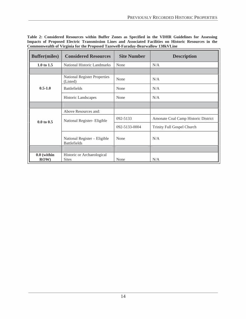
TAZEWELL-FARADAY-BEARWALLOW 138KV TRANSMISSION LINE
Review of the VDHR VCRIS inventory records indicated fourteen (14) previously recorded architectural properties and one (1) previously recorded archaeological site are located within 1.5 miles of the proposed project’s ROW.
Architectural Resources
There are no previously recorded NHL’s located within 1.5-miles of the proposed project’s ROW. There are no previously recorded historic districts or individual properties listed on the NRHP within 1.0-mile of the proposed project’s ROW. There is one previously recorded historic district and one individual property that are eligible for the listing in the NRHP located within 0.5 miles of the proposed project’s ROW. There are no previously recorded properties located within the proposed project’s ROW. Resources within their buffer zones are provided in Table 2.
There are two (2) NRHP-eligible properties located within 1.0-mile of the proposed project’s ROW (Figures 5 through 8). These include:
Amonate Historic District (VDHR# 092-5133);
Trinity Full Gospel Church (VDHR# 092-5133-0004)
Archaeological Sites
There are no previously recorded archaeological sites located within or adjacent to the proposed project’s ROW.
PREVIOUSLY RECORDED HISTORIC PROPERTIES
14
Table 2: Considered Resources within Buffer Zones as Specified in the VDHR Guidelines for Assessing Impacts of Proposed Electric Transmission Lines and Associated Facilities on Historic Resources in the Commonwealth of Virginia for the Proposed Tazewell-Faraday-Bearwallow 138kVLine
Buffer(miles) Considered Resources Site Number Description
1.0 to 1.5 National Historic Landmarks None N/A
0.5-1.0
National Register Properties (Listed) None N/A
Battlefields None N/A
Historic Landscapes None N/A
0.0 to 0.5
Above Resources and:
National Register- Eligible 092-5133 Amonate Coal Camp Historic District
092-5133-0004 Trinity Full Gospel Church
National Register – Eligible Battlefields
None N/A
0.0 (within ROW)
Historic or Archaeological Sites None N/A

PREV
IOU
SLY
REC
OR
DED
HIS
TOR
IC P
RO
PER
TIES
15
Figu
re 5
. Taz
ewel
l-Far
aday
-Bea
rwal
low
, 1 o
f 4 S
ourc
e: N
RG

PREV
IOU
SLY
REC
OR
DED
HIS
TOR
IC P
RO
PER
TIES
16
Figu
re 6
. Taz
ewel
l-Far
aday
-Bea
rwal
low
, 2 o
f 4 S
ourc
e: N
RG

PREV
IOU
SLY
REC
OR
DED
HIS
TOR
IC P
RO
PER
TIES
17
Figu
re 7
. Taz
ewel
l-Far
aday
-Bea
rwal
low
, 3 o
f 4 S
ourc
e: N
RG

PREV
IOU
SLY
REC
OR
DED
HIS
TOR
IC P
RO
PER
TIES
18
Figu
re 8
. Taz
ewel
l-Far
aday
-Bea
rwal
low
, 4 o
f 4 S
ourc
e: N
RG
PREVIOUSLY RECORDED HISTORIC PROPERTIES
19
WHITEWOOD 138 KVEXTENSION
The 0.5-mile Whitewood 138 kV Extension will be located in Buchanan County and will proceed west from the new Whitewood Switchyard to the existing Grassy Creek–Hales Branch 138 kV Transmission line Structure No. 26. No historic or archaeological resources occur in the tiered study area for Whitewood Extension or the Whitewood Switchyard. Therefore, the Whitewood 138 kV Extension will not be addressed further in this report.
EXPECTED FIELDRECONNAISSANCE RESULTS
The character of the area within each proposed project’s ROW was historically used for coal mining. The terrain is mountainous and rugged, with intervening valleys and rivers, and steep, winding roads. While many towns served the growing coal operations of the early twentieth century, many dwellings have since fallen into a state of deterioration. In 2001, Tazewell County and VDHR conducted a historic architecture survey of Tazewell County, which included survey of 250 resources of which six resources and six districts were determined eligible for listing in the NRHP. Therefore, the potential for previously unrecorded historic properties to be located within the project study area is low.
Much of each project’s ROW is located within areas where mining activities have been conducted resulting in alterations to the landscape over time. Additionally, the Tazewell-Faraday-Bearwallow Transmission Line upgrades are located within an existing ROW. The likelihood, therefore, of archaeological sites listed or considered eligible for listing in the NRHP to be located within the ROW is low.

PREVIOUSLY RECORDED HISTORIC PROPERTIES
20
THIS PAGE LEFT INTENTIONALLY BLANK

RESULTS OF FIELD RECONNAISSANCE
21
RESULTS OF FIELD RECONNAISSANCE
In accordance with the VDHR guidelines for assessing impacts of proposed electric transmission lines on historic resources, each of the previously recorded historic properties either listed or determined eligible for listing in the NRHP located within 1-mile or 0.5 miles of the ROW were field verified and photo documented. The results of the field reconnaissance for each resource are summarized below.
RICHLANDS-WHITEWOOD 138KV TRANSMISSION LINE
Tazewell Avenue Historic District (VDHR# 148-5020)
The Tazewell Avenue Historic District is located in the western part of the Town of Richlands in Tazewell County, Virginia. It encompasses approximately ten blocks laid out in a grid. The Clinch River curves around the northeast corner of the district and separates it from the rest of downtown Richlands. The town was developed by the Clinch Valley Coal and Iron Company in 1888 in anticipation of the arrival of the Norfolk and Western Railroad in 1889. Although the Railroad never arrived, the Richlands Brickyard local coal mines thrived in the early twentieth century leading to a lively commercial district in town.
The Tazewell Avenue Historic District was built primarily as a residential area during the early 1900s and continued to develop through the 1950s. There are 72 primary resources with all but 19 considered contributing to the historic district. The housing is representative of diverse incomes and popular architectural styles and forms such as Queen Anne cottages, single-pile dwellings, bungalows, Craftsman, Cape Cod, Minimal Traditional, and Ranches. In addition to the residential area, commercial activity grew along the southern edge of the district along Front Street representing the prosperity of Richlands in the early twentieth century and consists mostly of two-story brick buildings that are unadorned or simply ornamented with pilasters and corbelled cornices.
The Tazewell Avenue Historic District is listed on the NRHP and VLR under Criterion A for its association with the planning and development of the town and for its significance in the history of local commerce. Additionally, it is listed under Criterion C for its architecture, which is representative of the town’s early and mid-twentieth century commercial and residential development. The period of significance for the district begins circa 1900, the date of the earliest building in the district, and ends in 1960.
The District is located in a valley within a mountainous region and two existing transmission line ROW’s are visible trending up the first mountain ridge to the north. An existing substation is located along the southern boundary of the District and power lines transect the District along 2nd
Street, as well as border the District along Front Street and Tower Avenue.
The nearest point within the District to the ROW is just under a quarter-mile, while the furthest point is slightly over a half-mile. While the transmission line begins at existing Structure No. 105, Structure Rich 2 will be the first new structure constructed within the ROW. Structure Rich 2 is located 0.3-miles further northwest on the second ridge. From the valley where the historic

RESULTS OF FIELD RECONNAISSANCE
22
district is located, it is not possible to see beyond the first mountain ridge, which obscures any direct site lines to the proposed new structures. As there will be no change in existing setting or view shed, the construction of this project will have no impact on the view from the District.
Figure 9 depicts the location of the Tazewell Avenue Historic District in relationship to the proposed Richlands-Whitewood ROW. Plates 1 through 8 illustrate the current setting within the District and Plates 2 and 5 illustrate the existing views from the District looking towards the proposed project.
Figure 10 illustrates the direction of the photo simulations for the Richlands-Whitewood 138kV Transmission Line. Figure 11 depicts the topography of the region and Figure 12 depicts the line of site. Figures 13 and 15 are the existing view from the Tazewell Avenue Historic District facing towards the existing ROW and Figures 14 and 16 are the photo simulation of the proposed structures standing in the same location as the previous image.

RESULTS OF FIELD RECONNAISSANCE
23
Figure 9. Tazewell Avenue Historic District (green) in relationship to transmission line (existing transmission lines are depicted by yellow dotted lines and the proposed transmission line is depicted by the red dotted line), and locations and directions of plates. Base Map Source: V-CRIS 2014.
1
8
7
6
54
3
2
N
Richlands Substation
Structure No. 105

RESULTS OF FIELD RECONNAISSANCE
24
Plate 1. Facing northwest from corner of Front Street and Fairfax Avenue.
Plate 2. Facing north from Fairfax Avenue at Second Street.

RESULTS OF FIELD RECONNAISSANCE
25
Plate 3. Facing south from Tazewell Avenue at Fourth Street.
Plate 4. Facing northeast from Fourth Street at Floyd Avenue.

RESULTS OF FIELD RECONNAISSANCE
26
Plate 5. Facing northeast from Fairfax Avenue at Fourth Street.
Plate 6. Facing south from Fairfax Avenue at Second Street.
RESULTS OF FIELD RECONNAISSANCE
27
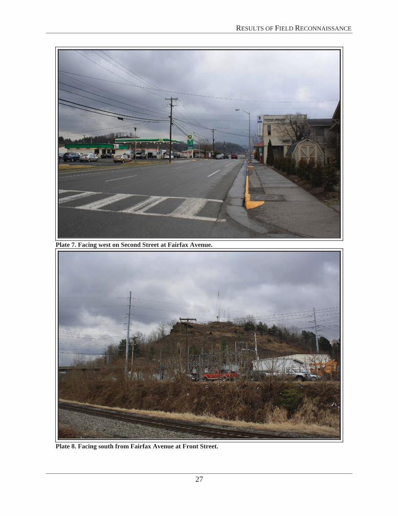
Plate 7. Facing west on Second Street at Fairfax Avenue.
Plate 8. Facing south from Fairfax Avenue at Front Street.

RESULTS OF FIELD RECONNAISSANCE
28
Figure 10. Location and direction of each photo simulation in relationship to the proposed Richlands-Whitewood 138kV Transmission Line (red dotted line) and existing transmission lines (yellow dotted lines). (Note: The locations of new structures depicted on the overview map are approximate. The final locations are dependent upon the final design and the completion of ground survey.)
Figure 11. Terrain in 3D view, facing northeast. Source: Terrain Navigator Pro.
Figures 13 and 14 Longitude: -81.806961 Latitude: 37.095601 Direction: 2° N
Figures 15 and 16 Longitude: -81.806703 Latitude: 37.096755 Direction: 3° N
Tazewell Ave Historic District
Existing Structure No. 105
ROW Direction
Rich 2
Rich 2 will be the first new structure on this transmission line

RESULTS OF FIELD RECONNAISSANCE
29
Figure 12. Line of site (blue line) from Tazewell Avenue Historic District towards structure Rich 2. First ridge obscures view towards proposed structures. Source: Terrain Navigator Pro.
Figure 13. Original image used for photo simulation, taken from corner of Fairfax Avenue and Second Street facing northeast, 0.45-miles from ROW. Red arrow points to existing Structure No. 105.
Tazewell Ave Historic District
Existing Structure No. 105
Rich 2

RESULTS OF FIELD RECONNAISSANCE
30
Figure 14. Viewshed will remain the same; photograph taken from corner of Fairfax Avenue and Second Street facing northeast, 0.45-miles from ROW. Red arrow points to existing Structure No. 105.
Figure 15. Original image used for photo simulation, taken from Tazewell Avenue between Second and Third Street facing east, 0.35-miles from ROW.

RESULTS OF FIELD RECONNAISSANCE
31
Figure 16. Viewshed will remain the same; photograph taken from Tazewell Avenue between Second and Third Street facing east, 0.35-miles from ROW. Red arrow points to existing Structure No. 105.
Richlands Historic District (VDHR# 148-5014)
The Richlands Historic District is located in downtown Richlands in Tazewell County, Virginia. The town was developed by the Clinch Valley Coal and Iron Company in 1888 in anticipation of the arrival of the Norfolk and Western Railroad in 1889. Although the company was bankrupted during the Panic of 1893, the Richlands Brickyard local coal mines thrived in the early twentieth century leading to a lively commercial district in town.
The Richlands Historic District encompasses approximately 18 blocks laid out in a grid, bounded by railroad tracks to the south and west, undeveloped land to the east, and a later residential neighborhood to the north. A new town hall was constructed in 2001 on a central block and was excluded from the district, creating an irregular historic district boundary configuration. The District is comprised of 86 buildings of an almost equal mix of commercial and residential, as well as three churches. One of the first buildings, the Williams House, was designed in the high-style Georgian Revival and is a sign of the expected prosperity of the town. The town achieved some prosperity after the 1893 panic and architectural styles represented in the District include Classical Revival, Late-Victorian cottages, and Craftsman-style bungalows. Later construction during the 1930s and 1940s consisted primarily of Cape Cod and Minimal Traditional homes. Much of the commercial buildings line Front Street and Second Street and date primarily from 1890 to 1930. They are mostly two-story, brick structures with minimal stylistic references, however, the oldest buildings in the district retain cast iron ornamentation.

RESULTS OF FIELD RECONNAISSANCE
32
The Richlands Historic District is listed on the NRHP and VLR under Criterion A for its association with the planning and development of the town and for its significance in the history of local commerce. It is also eligible under Criterion C for its architecture, which is representative of the town's late-nineteenth and early-twentieth century commercial and residential development. The period of significance for the District begins circa 1889, the date of the earliest building in the district, and ends in 1956.
The nearest point within the District to the new ROW is 0.6-miles and the furthest point is 0.9-miles. The District is located in a mountainous region and from many locations, two existing transmission line ROW’s are visible trending up the first mountain ridge to the northwest. While the new structures may be partially visible, they are not out of character with the existing setting, which includes cleared ROW, structures, and transmission lines. The new transmission line begins at existing Structure No. 105, which is 0.6 miles from the closest edge of the District. Structure Rich 2 will be the first new structure constructed within the new ROW and is located 0.3-miles further northwest on the second ridge making it 0.9 miles from the closest edge of the District. From the valley where the historic district is located, views beyond the first mountain ridge are extremely limited and any direct site lines to the proposed new structures are minimal to nonexistent due to intervening topography and distance. As there will be no significant change in existing setting or view shed, the construction of this project will have no impact on the view from the District.
Figure 17 depicts the location of the Richlands Historic District in relationship to the proposed Richlands-Whitewood ROW. Plates 9 through 17 illustrate the current setting within the District, and Plates 18 through 20 illustrate the existing views from the District.
Figure 18 illustrates the direction of the photo simulations for the Richlands-Whitewood 138kV Transmission Line. Figure 19 depicts the topography of the region and Figure 20 depicts the line of site from the historic district. Photo simulations of the proposed line are depicted in Figures 21 and 22. Figure 21 is the existing view from the Richlands Historic District facing towards the existing ROW and Figure 22 is the photo simulation of the proposed structures standing in the same location as the previous image.

RESULTS OF FIELD RECONNAISSANCE
33
Figure 17. Richlands Historic District (green) in relationship to transmission line (existing transmission lines are depicted by yellow dotted lines and the proposed transmission line is depicted by the red dotted line), and locations and directions of plates. Base Map Source: V-CRIS 2014
N
910
1211
14
15
13
16
19
18
17
20
Richlands Substation
Existing Structure No. 105

RESULTS OF FIELD RECONNAISSANCE
34
Plate 9. Facing northwest from Second at Lee Street.
Plate 10. Facing east on Front Street at Railroad Avenue.

RESULTS OF FIELD RECONNAISSANCE
35
Plate 11. Facing northeast on Suffolk Avenue at Front Street.
Plate 12. Facing East on Front at Scott Street.

RESULTS OF FIELD RECONNAISSANCE
36
Plate 13. Facing northeast on Grayson Avenue at Second Street.
Plate 14. Facing southwest on Lee at Fourth Street.

RESULTS OF FIELD RECONNAISSANCE
37
Plate 15. Facing east on Grayson Avenue at Third Street.
Plate 16. Facing east on Fourth at Lee Street.

RESULTS OF FIELD RECONNAISSANCE
38
Plate 17. Facing southwest on Norfolk at Second Street.
Plate 18. General setting facing northeast from Railroad Avenue and Third Street.

RESULTS OF FIELD RECONNAISSANCE
39
Plate 19. General setting facing northeast on Suffolk Avenue at Fifth Street.
Plate 20. General setting facing southeast on Front at Scott Street.

RESULTS OF FIELD RECONNAISSANCE
40
Figure 18. Location and direction of each photo simulation in relationship to the proposed Richlands-Whitewood 138kV Transmission Line (red dotted line) and existing transmission lines (yellow dotted lines). (Note: The locations of new structures depicted on the overview map are approximate. The final locations are dependent upon the final design and the completion of ground survey.)
Figure 19. Terrain in 3D view, facing northwest. Source: Terrain Navigator Pro.
Figures 21 and 22 Longitude: -81.794241 Latitude: 37.095277 Direction: 312° NW
RichlandsHistoric District
Existing Structure No. 105
ROW Direction
Rich 2 will be the first new structure on this transmission line
RichlandsSubstation

RESULTS OF FIELD RECONNAISSANCE
41
Figure 20. Line of site (blue line) from Richlands Historic District towards Rich 2. The first ridge largely obscures view towards proposed structures from the majority of District. Source: Terrain Navigator Pro.
Figure 21. Original image used for photo simulation, taken from Lee Street at Grayson Avenue facing northwest, 0.85-miles from ROW. Red arrow points to existing structure.
RichlandsHistoric District
Existing Structure No. 105 Rich 2

RESULTS OF FIELD RECONNAISSANCE
42
Figure 22. Viewshed will remain the same; photograph taken from Lee Street at Grayson Avenue facing northwest, 0-85-miles from ROW. Red arrow points to existing Structure No. 105.
Williams House (VDHR# 148-5018) The Williams House is located at the north corner of the intersection of Suffolk Avenue and Front Street and is situated facing south. The building is on the southern boundary of the Richlands Historic District. The property is bounded by an iron fence and has a small, flat, grass lawn. There is a parking lot behind the building, and an outbuilding that was used historically as an operating room.
The Williams House is a Georgian Revival dwelling constructed in 1890 in the town of Richlands. The 2 ½ story wood-frame building rests on a continuous stone foundation, is clad with weatherboard siding, and is covered by hipped roof. A one story porch supported by Tuscan columns spans the façade, beneath which is an off-center entrance covered by a transom light with an oval window beside the door. Three dormers pierce the roof and the middle dormer has a scrolled pediment topped by an urn finial. A wooden balustrade runs the perimeter of the roof and at either end are interior corbelled brick chimneys.
The building was constructed in 1890 and is tied to the founding of Richlands. It was originally constructed for the Clinch Valley Coal and Iron Company, the investment group that planned and founded Richlands. The building’s architecture is a testament to the grand dreams of the investment group, which was to make Richlands the Pittsburgh of the South. The building was later purchased by Dr. W. R. Williams in 1901, where he created the first hospital in Richlands

RESULTS OF FIELD RECONNAISSANCE
43
using an outbuilding as an operating room and housing patients in his home. The building is currently used as the Tazewell County Public Library, Richlands Branch.
The Williams House is individually listed on the NRHP and VLR for its significance under commerce, community planning, and social/humanitarian themes, and is also considered a contributing resource to the NRHP and VLR listed Richlands Historic District.
The Williams House is located 0.77-miles from the proposed Richlands-Whitewood 138kV Transmission Line project. The area surrounding the property is primarily commercial and Front Street, on which it is situated, is a primary traffic corridor for the town. Mountain views are visible when looking either northwest or southeast down Front Street. Two existing ROWs are visible when facing northwest towards the proposed project; however, the structures within the proposed project’s ROW will be barely visible from outside the house as the building itself and surrounding buildings obscure views looking back towards the line. The existing ROW that the proposed structures will be in is slightly visible from the southern corner of the intersection of Suffolk Avenue and Front Street, opposite of where the house is located at this intersection. The new transmission line begins at existing Structure No. 105, which is 0.77 miles from the Williams House. Structure Rich 2 will be the first new structure constructed within the new ROW and is located 0.3-miles further northwest on the second ridge making it 1.07 miles from the Williams House. The house is over a mile from the first new tower and located in a developed setting. Between the distance and the intervening buildings, vegetation, and terrain, any direct site lines to the proposed new structures are obscured. As there will be no change in existing setting or view shed, the construction of this project will have no impact on the view from the District.
Figure 23 depicts the location of the Williams House in relationship to the proposed Richlands-Whitewood ROW. Plates 21 through 24 illustrate the dwelling and current setting, and Plates 25 and 26 illustrate the existing view sheds from the building.
Photo simulations of the proposed transmission line are depicted in Figures 25 and 26. Figure 24 illustrates the direction of the photo simulations for the Richlands-Whitewood 128kV Transmission Line. Figure 25 is the existing view from the Richlands Historic District facing towards the existing ROW and Figure 26 is the photo simulation of the proposed structures standing in the same location as the previous image.

RESULTS OF FIELD RECONNAISSANCE
44
Figure 23. Williams House (green) in relationship to ROW (existing transmission lines are depicted by yellow dotted lines and the proposed transmission line is depicted by the red dotted line), and locations and directions of plates. Base Map Source: V-CRIS 2014.
N
23 2122
24 25
26
Richlands Substation
Structure No. 105

RESULTS OF FIELD RECONNAISSANCE
45
Plate 21. Williams House, facing north.
Plate 22. Williams house, front façade, facing north.

RESULTS OF FIELD RECONNAISSANCE
46
Plate 23. Williams house, facing east.
Plate 24. Outbuilding, facing east.

RESULTS OF FIELD RECONNAISSANCE
47
Plate 25. Views from street facing northwest.
Plate 26. Views from front lawn facing northwest.

RESULTS OF FIELD RECONNAISSANCE
48
Figure 24. Location and direction of each photo simulation in relationship to the proposed Richlands-Whitewood 138kV Transmission Line (red dotted line) and existing transmission lines (yellow dotted lines). (Note: The locations of new structures depicted on the overview map are approximate. The final locations are dependent upon the final design and the completion of ground survey.)
Figures 25 and 26Longitude: -81.798219
Latitude: 37.093246Direction: 303° NW
Rich 2 will be the first new structure on this transmission line
RichlandsSubstation

RESULTS OF FIELD RECONNAISSANCE
49
Figure 25. Original image used for photo simulation, taken from Williams House (within Richlands HD), Front at Suffolk facing north, 0.77-miles from ROW. Red arrow points to existing structure.
Figure 26. Viewshed will remain the same; photograph taken from Williams House (within Richlands HD), Front at Suffolk facing north, 0.77-miles from ROW. Red arrow points to existing Structure No. 105.

RESULTS OF FIELD RECONNAISSANCE
50
TAZEWELL-FARADAY-BEARWALLOW 138KV TRANSMISSION LINE
Amonate Coal Camp Historic District (VDHR# 092-5133) The Amonate Coal Camp Historic District is located 8.5-miles north of Tazewell near the West Virginia border. The District consists of approximately 100 buildings along a one-mile stretch on either side of Amonate Road, which trends northeast-southwest. The town was built by the Pocahontas Fuel Company in the 1920s1 and was one of the last original coal towns from the Golden Age of Appalachian Coal Mining.2
The Amonate Historic District was evaluated as part of the VDHR Survey and Planning Cost Share program in 2001 and was determined eligible by VDHR as locally significant under Criterion A for community development and Criterion C for architecture. The houses are representative of houses built by the coal company in a coal camp to house workers and their families. All of the dwellings are single family, wood frame, vernacular folk style buildings set on urban scale lots and almost all have porches facing the street. The southern end of Amonate Road contains mostly one story dwellings while the northern end of the street has mostly two story dwellings and likely housed upper-level employees.
The nearest point within the District to the ROW is 0.2-miles, while the furthest point is 1.2-miles. The District is located in a valley within a mountainous region and the existing ROW is not visible from Amonate Road due to the terrain and existing vegetation. Given the presence of an existing ROW, vegetation, and high relief topography it is unlikely that the new structures constructed within the existing ROW will be visible or introduce a new visual element in to the current viewscape of the District. One structure will be partially visible from the northern end of the district, however, the view looking away from the historic district does not contribute to the setting. It is, therefore, D+A’s opinion that the proposed project will have a minimal impact on the Amonate Historic District and its current setting.
Figure 27 depicts the location of the Amonate Historic District in relationship to the proposed Tazewell-Faraday-Bearwallow ROW and Figure 28 depicts the topography of the region. Plates 27 through 30 illustrate the current setting within and outside the district.
Photo simulations of the proposed line are depicted in Figures 30 and 31. Figure 29 illustrates the proposed structure locations for the Tazewell-Faraday-Bearwallow 128kV Transmission Line. Figure 30 is the existing view from the Amonate Coal Camp Historic District facing northeast towards the existing ROW, which is located 0.25-miles away. Figure 31 is the photo simulation of the proposed structures standing in the same location as the previous image. The structures have been overlaid in the image, structures that are behind terrain will not be visible but have been colored gray for the purpose of this study.
1 Shell record for district states 1924-1950, however individual representative buildings in the file are 1919, 1920, and 1925. Coalcampusa.com states the Coal Camp was constructed ca1930. 2 http://www.coalcampusa.com/swva/pocahontas/pocahontas.htm

RESULTS OF FIELD RECONNAISSANCE
51
Figure 27. Amonate Coal Camp Historic District in relationship to the transmission line (red dotted line) and locations/directions of plates. Base Map Source: V-CRIS 2014.
Figure 28. Terrain in 3D view, facing northwest. Source: Terrain Navigator Pro.
Amonate Coal Camp Historic District
Closest Structure ROW Direction
27
30
28
29
N

RESULTS OF FIELD RECONNAISSANCE
52
Plate 27. Northern end of Amonate Road, facing southwest.
Plate 28. Bungalows on southern end, facing south.
RESULTS OF FIELD RECONNAISSANCE
53
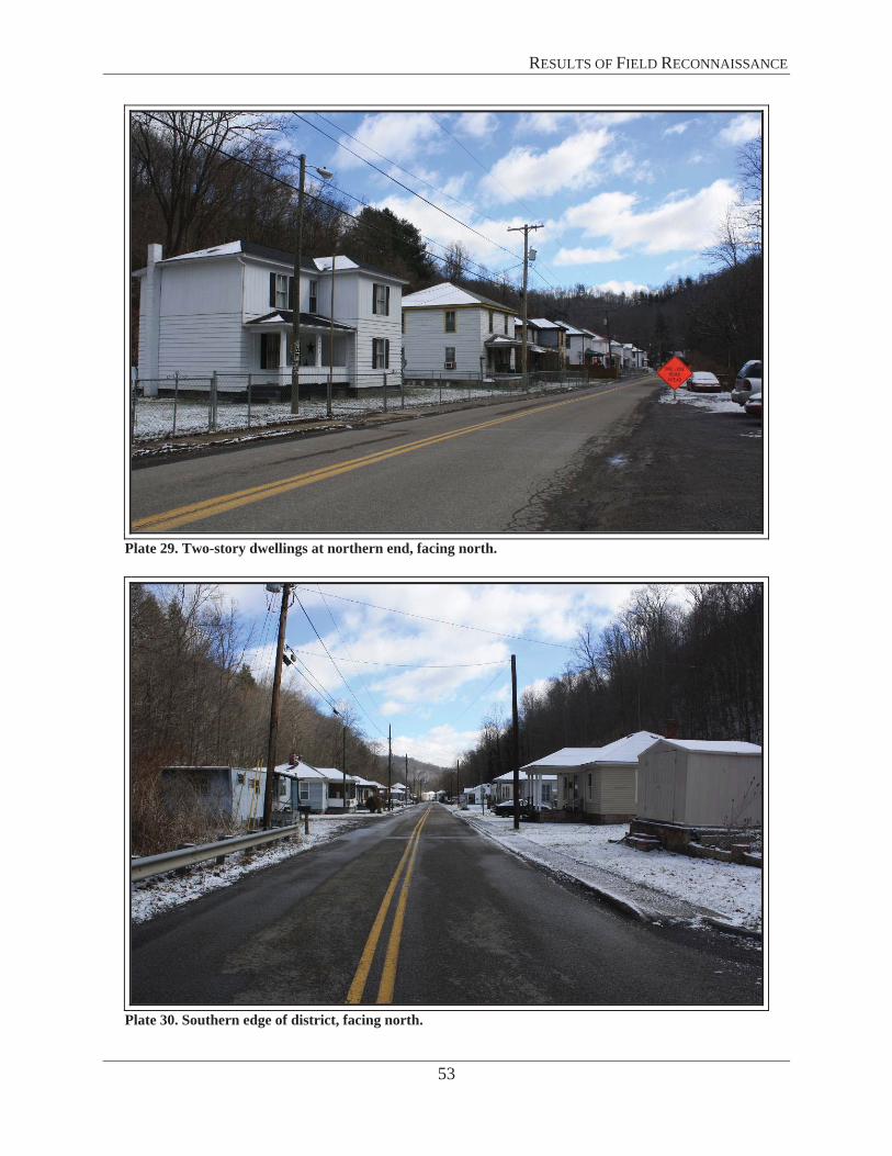
Plate 29. Two-story dwellings at northern end, facing north.
Plate 30. Southern edge of district, facing north.

RESULTS OF FIELD RECONNAISSANCE
54
Figure 29. Location and direction of each photo simulation in relationship to the proposed Tazewell-Faraday-Bearwallow 138kV Transmission Line (yellow dotted line).
Figure 30. Original image use for photo simulation, taken from northern end of Amonate Road, facing northeast, 0.25-miles from ROW.
Figures 30 and 31 Longitude: -81.633561 Latitude: 37.193051 Direction: 9° N

RESULTS OF FIELD RECONNAISSANCE
55
Figure 31. Photo simulation of proposed structures, taken from northern end of Amonate Road, facing northeast, 0.25-miles from ROW. Structures 55 and 56 would not be visible from this location due to the existing terrain. These structures would be located on the distant side of the mountain.
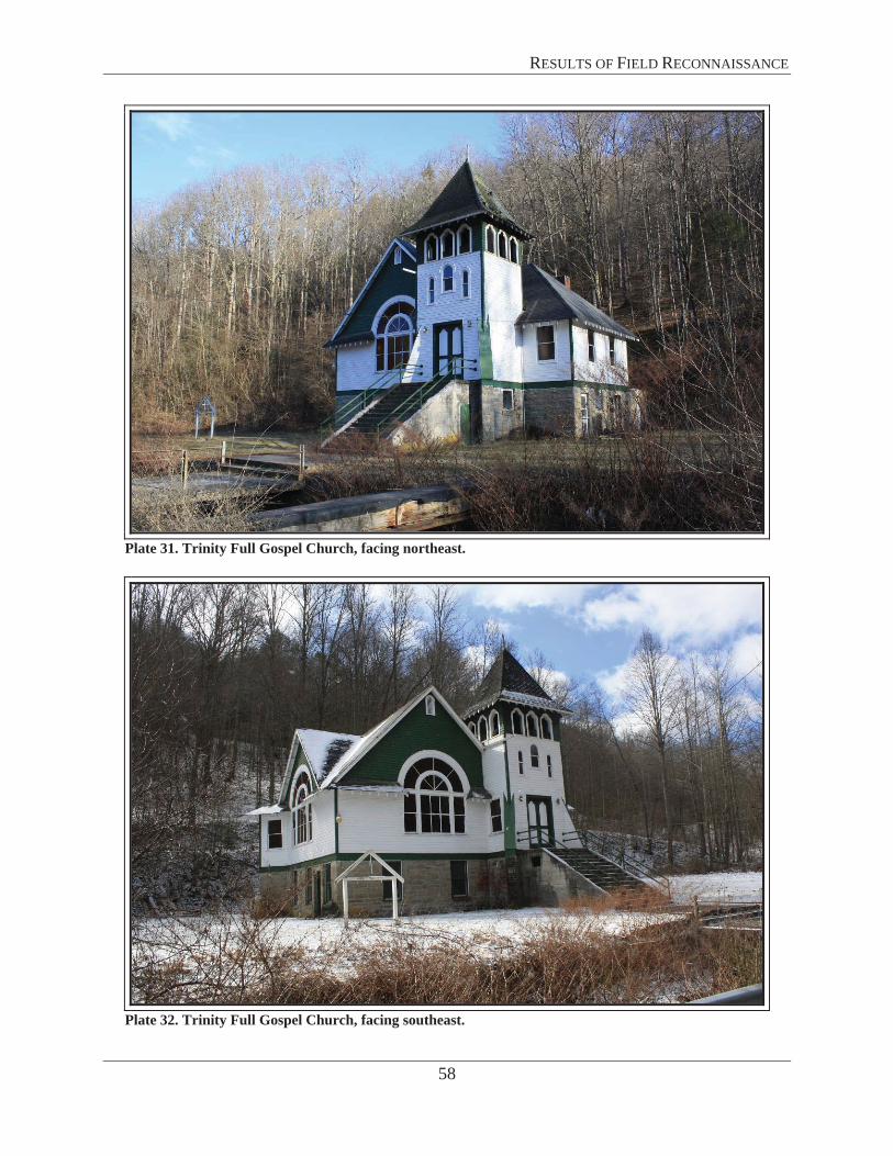
Trinity Full Gospel Church (VDHR# 092-5133-0004) The Trinity Full Gospel Church is located on the southern side of Amonate Road at the northeastern end of the Amonate Historic District. A creek runs parallel to the road and is crossed by a concrete bridge. The terrain rises steeply behind the church and is wooded and mountains are visible in all directions.
The church, historically known as the Amonate Methodist Church, was constructed ca.1935 in the Gothic Revival Style. The one story, frame church rests on a stone foundation with a full basement. The double leaf entrance doors are flanked by battered buttresses located in a corner structure with a kicked hipped roof and triple-arched head belfry with bell. A large arched window pierces the façade. The Church is covered by a cross gable roof with exposed rafters.
The Trinity Full Gospel Church is a well preserved and architecturally significant example of religious structures built in company towns or coal camps by coal companies. The church is considered individually eligible, as well as a contributing resource to the eligible Amonate Historic District.
The nearest point from the Church to the ROW is 0.2-miles. The existing ROW is not visible from Amonate Road or the church. All but one structure will be blocked by terrain and will not be visible. One structure will protrude partially above the terrain, however it is consistent with the existing setting and is likely be obscured by existing vegetation. It is therefore D+A’s
STRUCTURE 54
STRUCTURE 55
STRUCTURE 56

RESULTS OF FIELD RECONNAISSANCE
56
opinion that the proposed project will have a minimal to no impact on the Trinity Full Gospel Church and its existing setting.
Figure 32 depicts the location of the Trinity Full Gospel Church in relationship to the proposed Tazewell-Faraday-Bearwallow ROW. Plates 31 and 32 illustrate the Church and its setting.
Photo simulations of the proposed line are depicted in Figures 34 and 35. Figure 33 illustrates the proposed structure locations for the Tazewell-Faraday-Bearwallow 128kV Transmission Line. Figure 34 is the existing view from the Trinity Full Gospel Church (within the Amonate Coal Camp Historic District) facing north towards the existing ROW, which is located 0.45-miles away. Figure 35 is the photo simulation of the proposed structures standing in the same location as the previous image. The structures have been overlaid in the image, structures that are behind terrain will not be visible but have been colored gray for the purpose of this study.

RESULTS OF FIELD RECONNAISSANCE
57
Figure 32. Trinity Full Gospel Church in relationship to ROW (red dotted line) and locations/directions of plates. Base Map Source: V-CRIS 2014.
3231
N
RESULTS OF FIELD RECONNAISSANCE
58
Plate 31. Trinity Full Gospel Church, facing northeast.
Plate 32. Trinity Full Gospel Church, facing southeast.

RESULTS OF FIELD RECONNAISSANCE
59
Figure 33. Location and direction of each photo simulation in relationship to the proposed Tazewell-Faraday-Bearwallow 138kV Transmission Line (yellow dotted line).
Figure 34. Original image use for photo simulation, taken from Trinity Full Gospel Church (within Amonate Coal Camp HD), facing north, 0.45-miles from ROW.
Figures 34 and 35 Longitude: -81.633717 Latitude: 37.193427 Direction: 37° N

RESULTS OF FIELD RECONNAISSANCE
60
Figure 35. Photo simulation of proposed structures, taken from Trinity Full Gospel Church (within Amonate Coal Camp HD), facing north, 0.45-miles from ROW. Structures 55 through 59 would not be visible from this location due to the existing terrain. These structures would be located on the distant side of the mountain.
STRUCTURE 55 STRUCTURE 56
STRUCTURE 57
STRUCTURE 59 STRUCTURE 58

ASSESSMENT OF POTENTIAL IMPACTS
61
ASSESMENT OF POTENTIAL IMPACTSPotential impacts to previously recorded historic properties listed or considered eligible for listing in the NRHP were assessed in accordance with the VDHR guidelines. For the purposes of this analysis, an impact is one that alters, either directly or indirectly, those qualities or characteristics that qualify a particular property for listing in the NRHP and does so in a manner that diminishes the integrity of a property’s materials, workmanship, design, location, setting, feeling, and association. With respect to transmission lines, direct impacts typically are associated with ground disturbance resulting from ROW clearing and structure construction. Indirect impacts typically are associated with the introduction of new visual elements or changes to the physical features of a property’s setting in a way that diminishes the integrity of the property’s significant features. Identified impacts are characterized as severe (fully visible and incompatible with character-defining viewshed or setting), moderate (partially visible and incompatible with character-defining viewshed or setting), or minimal (not visible and/or not out of character with existing viewscape). Below is an assessment of potential impacts on previously recorded historic properties located within 1.0-miles and 0.5 miles of the proposed project’s ROW that are listed or considered eligible for listing in the NRHP. Table 3 summarizes the determination of potential impact for each resource considered in this analysis.
The proposed project involves new, rebuild, and upgrades of electrical transmission lines, a new switchyard, and substation improvements in Tazewell and Buchanan Counties, Virginia and in McDowell County, West Virginia. Portions of the project in Virginia include three transmission line segments and associated substation improvements.
RICHLANDS-WHITEWOOD 138KV TRANSMISSION LINE
The Richlands-Whitewood 138kV Transmission Line will involve the construction of a new single circuit line, a new Whitewood 138kV Switchyard, modifications to the Richlands Substation, and construction of the Whitewood 138kV Extension, which trends northwest from the Whitewood Substation. The new ROW will be 100 feet wide and have transmission structures that are approximately 85 feet tall.
As discussed earlier in the Field Results section, the Tazewell Avenue Historic District is listed on the NRHP under Criterion A for its association with the planning and development of the town and for its significance in the history of local commerce. Additionally, it is listed under Criterion C for its architecture, which is representative of the town’s early and mid-twentieth century commercial and residential development. Given that structure Rich 2 will be the first new structure that is constructed within the ROW and will not be visible, it is D+A’s opinion that there will be no impact on the view shed.
The Richlands Historic District is listed on the NRHP under Criterion A for its association with the planning and development of the town and for its significance in the history of local commerce. It is also eligible under Criterion C for its architecture that is representative of the town's late-nineteenth and early-twentieth century commercial and residential development. Given that structure Rich 2 will be the first new structure that is constructed within the ROW and will not be visible, it is D+A’s opinion that there will be no impact on the view shed.

ASSESSMENT OF POTENTIAL IMPACTS
62
The Williams House is a Georgian Revival dwelling constructed in 1890 in the town of Richlands. The house is listed on the NRHP and VLR for its significance under commerce, community planning, and social/humanitarian themes and is also considered a contributing resource to the NRHP and VLR listed Richlands Historic District. An existing ROW is visible from the house when facing northwest towards the proposed project; however the proposed structures within the project’s ROW will be barely visible from outside the house as the building itself and the other city buildings obscure views looking back towards the line. The existing ROW that the proposed structures will be within is slightly visible from the southern corner of the intersection of Suffolk Avenue and Front Street. Given that structure Rich 2 will be the first new structure that is constructed within the ROW and will not be visible, it is D+A’s opinion that there will be no impact on the view shed.
TAZEWELL-FARADAY-BEARWALLOW 138KV TRANSMISSION LINE
The project will also include upgrades to the Tazewell-Faraday-Bearwallow Transmission Line. APco plans to rebuild approximately 12.3 miles of an existing 69kV line to 138kV, 8.6 miles of which are located in Tazewell County, Virginia, with the remainder located in West Virginia. In addition, improvements are to be made to the existing Tazewell and Bearwallow substations along this line. The existing transmission structures within the ROW are 65 feet in height, and the new structures will be approximately 85 feet tall.
The Amonate Coal Camp Historic District is representative of houses built by coal companies to house workers and their families and was determined eligible for listing in the NRHP by VDHR as locally significant under Criterion A for community development and Criterion C for architecture. The existing ROW is not visible from Amonate Road or the historic district due to the terrain and vegetation and most new structures constructed within the existing ROW will not be visible. One structure will be partially visible from the northern end of the district, however, the view looking away from the historic district does not contribute to the setting. Therefore, it is D+A’s opinion that the proposed project will have a minimal impact on the setting and viewshed of the Amonate Coal Camp Historic District.
The Trinity Full Gospel Church is a well preserved and architecturally significant example of religious structures built in company towns or coal camps by coal companies. The church is individually eligible under Criterion A (religion) and C (architecture) and is a contributing resource to eligible Amonate Coal Camp Historic District. The existing ROW is not visible from Amonate Road or the church due to the terrain and vegetation. While one of the proposed towers may be visible, it is consistent with the existing setting and likely to be obscured by vegetation. It is therefore D+A’s opinion that the proposed project will have minimal to no impact on the setting and viewshed of the Trinity Full Gospel Church.
No previously recorded archaeological sites are located within or adjacent to either the existing or proposed ROWs. Given the mountainous terrain and the limited potential for archaeological sites to be present on severely sloping terrain, impacts to archaeological sites is expected to be minimal.

ASSESSMENT OF POTENTIAL IMPACTS
63
Table 3: Assessment of Impacts Summary for Architectural Resources.
Resource # Resource Name NationalRegister Status Potential Impact
Richlands-Whitewood 138kV Transmission Line
148-5020 Tazewell Avenue Historic District Listed None
148-5014 Richlands Historic District Listed None
148-5018 Williams House Listed None
Tazewell-Faraday-Bearwallow 138kV Transmission Line
092-5133 Amonate Coal Camp Historic District Eligible Minimal
092-5133-0004 Trinity Full Gospel Church Eligible Minimal to None

ASSESSMENT OF POTENTIAL IMPACTS
64
THIS PAGE LEFT INTENTIONALLY BLANK

REFERENCES
65
REFERENCES
National Park Service 2009 “Civil War Sites Advisory Commission Report Update and Resurvey,” American
Battlefield Protection Program
Natural Resource Group, LLC 2014 Tazewell-Buchanan Area 138 kV Transmission Improvements Project Transmission
Line and Substation Construction and Improvements Tazewell and Buchanan Counties, Virginia Historic Resources Pre-Application Analysis Report
Virginia Department of Historic Resources 2008 Guidelines for Assessing Impacts of Proposed Electric Transmission Lines and
Associated Facilities on Historic Resources in the Commonwealth of Virginia
Virginia Department of Historic Resources Virginia Cultural Resource Information System, https://vcris.dhr.virginia.gov/vcris/Account/Login?ReturnUrl=%2fvcris%2f?, accessed March 15, 2014

REFERENCES
66
THIS PAGE LEFT INTENTIONALLY BLANK


Administrative Services 10 Courthouse Ave. Petersburg, VA 23803 Tel: (804) 862-6408 Fax: (804) 862-6196
Capital Region Office 2801 Kensington Avenue Richmond, VA 23221 Tel: (804) 367-2323 Fax: (804) 367-2391
Tidewater Region Office 14415 Old Courthouse Way 2nd Floor Newport News, VA 23608 Tel: (757) 886-2818 Fax: (757) 886-2808
Western Region Office 962 Kime Lane Salem, VA 24153 Tel: (540) 387-5443 Fax: (540) 387-5446
Northern Region Office 5357 Main Street PO Box 519 Stephens City, VA 22655 Tel: (540) 868-7029 Fax: (540) 868-7033
COMMONWEALTH of VIRGINIA Department of Historic Resources
2801 Kensington Avenue, Richmond, Virginia 23221 Molly Joseph Ward Secretary of Natural Resources
Julie V. Langan Director Tel: (804) 367-2323 Fax: (804) 367-2391 www.dhr.virginia.gov
May 15, 2014 Ms. Larissa A. Thomas, Ph.D. Natural Resource Group 121 West Trade Street, Suite 2350 Charlotte, NC 28202 Re: Tazewell-Buchanan Area 138kV Improvements Project – Pre-Application Analysis
Tazewell and Buchanan Counties, Virginia DHR File No. 2014-0309 Dear Ms. Thomas: We have received for review the report, Pre-Application Analysis for Cultural Resources of the Tazewell – Buchanan Area 138kV Transmission Improvements Project, Tazewell and Buchanan Counties, prepared by Dutton + Associates, LLC (March 2014) in accordance with Section I of DHR’s Guidelines for Assessing Impacts of Proposed Electric Transmission Lines and Associated Facilities on Historic Resources in the Commonwealth of Virginia (2008). We have also received an addendum report for a reroute of the New Richlands-Whitewood segment dated May 2, 2014. The below comments are provided as technical assistance to Appalachian Power Company (AEP) in the preparation of an application to the State Corporation Commission (SCC). We have not been notified by any Federal agency of their involvement in this project; however, we reserve the right to provide additional comment pursuant to the National Historic Preservation Act, if applicable. The pre-application analysis and addendum consider the potential impact of the proposed project on recorded archaeological sites and on known historic architectural properties listed or previously determined eligible for listing in the Virginia Landmarks Register (VLR) and the National Register of Historic Places (NRHP) within a tiered study area. DHR’s comments on the pre-application analysis are provided in the attached table and utilize the following scale in describing impacts:
None – Project is not visible from the property Minimal – Occur within viewsheds that have existing transmission lines, locations where there will
only be a minor change in tower height, and/or views that have been partially obstructed by intervening topography and vegetation.

Page 2 May 15, 2014 DHR File No. 2014-0309
Administrative Services 10 Courthouse Ave. Petersburg, VA 23803 Tel: (804) 862-6416 Fax: (804) 862-6196
Capital Region Office 2801 Kensington Ave. Richmond, VA 23221 Tel: (804) 367-2323 Fax: (804) 367-2391
Tidewater Region Office 14415 Old Courthouse Way 2nd Floor Newport News, VA 23608 Tel: (757) 886-2807 Fax: (757) 886-2808
Western Region Office 962 Kime Lane Salem, VA 24153 Tel: (540) 387-5428 Fax: (540) 387-5446
Northern Region Office 5357 Main Street P.O. Box 519 Stephens City, VA 22655 Tel: (540) 868-7029 Fax: (540) 868-7033
Moderate – Include viewsheds with expansive views of the transmission line, more dramatic changes in the line and tower height, and/or an overall increase in the visibility of the route from the historic properties.
Severe – Occur within viewsheds that do not have existing transmission lines and where the views are primarily unobstructed, locations where there will be a dramatic increase in tower visibility due to the close proximity of the route to historic properties, and viewsheds where the visual introduction of the transmission line is a significant change in the setting of the historic properties.
To summarize, the pre-application analysis and addendum identify three (3) VLR/NRHP-listed architectural resources, two (2) VLR/NRHP-eligible architectural resources, and no previously identified archaeological sites within the tiered study area. These numbers include two (2) landmarks and three (3) historic districts. Based upon a review of the information provided, it is our opinion that the proposed project would have minimal impacts to two (2) VLR/NRHP eligible resources and no impacts to the other three (3) VLR/NRHP listed resources. Impacts to unrecorded and/or unevaluated archaeological and historic architectural resources remain unassessed. In accordance with Section II of the above-referenced Guidelines and to fully identify and address impacts to historic resources, we recommend the following:
1. Comprehensive archaeological and architectural surveys in accordance with DHR guidelines by qualified professionals prior to construction of any SCC-approved alternative.
2. Evaluation of all identified resources for listing in the VLR/NRHP. 3. Assessment of potential direct and indirect impacts to all VLR/NRHP-eligible/listed resources,
including previously inaccessible properties. 4. Avoidance, minimization, and/or mitigation of moderate to severe impacts to VLR/NRHP-eligible/listed
resources by AEP in consultation with DHR and other stakeholders. Thank you for the opportunity to review this application. If you have any questions concerning these comments, please contact me at [email protected]. Sincerely, Roger W. Kirchen, Director Review and Compliance Division

ATTACHMENT A – Tazewell-Buchanan Area 138kV Transmission Improvements Project May 15, 2014 DHR File No. 2014-0309
Administrative Services 10 Courthouse Ave. Petersburg, VA 23803 Tel: (804) 862-6416 Fax: (804) 862-6196
Capital Region Office 2801 Kensington Ave. Richmond, VA 23221 Tel: (804) 367-2323 Fax: (804) 367-2391
Tidewater Region Office 14415 Old Courthouse Way 2nd Floor Newport News, VA 23608 Tel: (757) 886-2807 Fax: (757) 886-2808
Western Region Office 962 Kime Lane Salem, VA 24153 Tel: (540) 387-5428 Fax: (540) 387-5446
Northern Region Office 5357 Main Street P.O. Box 519 Stephens City, VA 22655 Tel: (540) 868-7029 Fax: (540) 868-7033
DHR ID # Resource Name/Address
VLR/NRHP Status
Distance from Line
Dutton Recommended
Impacts – March 2014
DHR Recommended
Impacts – March 2014
148-5020 Tazewell Ave Historic District
VLR/NRHP Listed
RW – within 0.25-miles
None None
148-5014 Richlands Historic District
VLR/NRHP Listed
RW – 0.6-miles None None
148-5018 Williams House VLR/NRHP Listed
RW – 0.77-miles
None None
092-5133 Amonate Coal Camp Historic District
VLR/NRHP Eligible
TFB – 0.2-miles
Minimal Minimal
092-5133-0004 Trinity Full Gospel Church
VLR/NRHP Eligible
TFB – 0.2-miles
Minimal to None
Minimal
Administrative Services 10 Courthouse Ave. Petersburg, VA 23803 Tel: (804) 862-6408 Fax: (804) 862-6196
Capital Region Office 2801 Kensington Avenue Richmond, VA 23221 Tel: (804) 367-2323 Fax: (804) 367-2391
Tidewater Region Office 14415 Old Courthouse Way 2nd Floor Newport News, VA 23608 Tel: (757) 886-2818 Fax: (757) 886-2808
Western Region Office 962 Kime Lane Salem, VA 24153 Tel: (540) 387-5443 Fax: (540) 387-5446
Northern Region Office 5357 Main Street PO Box 519 Stephens City, VA 22655 Tel: (540) 868-7029 Fax: (540) 868-7033
COMMONWEALTH of VIRGINIA Department of Historic Resources
2801 Kensington Avenue, Richmond, Virginia 23221 Molly Joseph Ward Secretary of Natural Resources
Julie V. Langan Director Tel: (804) 367-2323 Fax: (804) 367-2391 www.dhr.virginia.gov
September 17, 2014 Ms. Larissa A. Thomas, Ph.D. Natural Resource Group 121 West Trade Street, Suite 2350 Charlotte, NC 28202 Re: Tazewell-Buchanan Area 138kV Improvements Project – Pre-Application Analysis Addendum
Tazewell and Buchanan Counties, Virginia DHR File No. 2014-0309 Dear Ms. Thomas: We have received for review an Addendum to the report, Pre-Application Analysis for Cultural Resources of the Tazewell – Buchanan Area 138kV Transmission Improvements Project, Tazewell and Buchanan Counties, prepared by Dutton + Associates, LLC in accordance with Section I of DHR’s Guidelines for Assessing Impacts of Proposed Electric Transmission Lines and Associated Facilities on Historic Resources in the Commonwealth of Virginia (2008). This Addendum addresses the potential impacts of three reroutes on the Tazewell-Bearwallow segment. On May 15, 2014, we provided comments on the original Pre-Application Analysis and an addendum for a reroute of the New Richlands-Whitewood segment. The below comments are provided as technical assistance to Appalachian Power Company (AEP) in the preparation of an application to the State Corporation Commission (SCC). We have not been notified by any Federal agency of their involvement in this project; however, we reserve the right to provide additional comment pursuant to the National Historic Preservation Act, if applicable. The pre-application analysis and addenda consider the potential impact of the proposed project on recorded archaeological sites and on known historic architectural properties listed or previously determined eligible for listing in the Virginia Landmarks Register (VLR) and the National Register of Historic Places (NRHP) within a tiered study area. DHR’s comments on the pre-application analysis are provided in the attached table and utilize the following scale in describing impacts:
None – Project is not visible from the property Minimal – Occur within viewsheds that have existing transmission lines, locations where there will
only be a minor change in tower height, and/or views that have been partially obstructed by intervening topography and vegetation.

ATTACHMENT – Tazewell-Buchanan Area 138kV Transmission Improvements Project September 17, 2014 DHR File No. 2014-0309
Administrative Services 10 Courthouse Ave. Petersburg, VA 23803 Tel: (804) 862-6416 Fax: (804) 862-6196
Capital Region Office 2801 Kensington Ave. Richmond, VA 23221 Tel: (804) 367-2323 Fax: (804) 367-2391
Tidewater Region Office 14415 Old Courthouse Way 2nd Floor Newport News, VA 23608 Tel: (757) 886-2807 Fax: (757) 886-2808
Western Region Office 962 Kime Lane Salem, VA 24153 Tel: (540) 387-5428 Fax: (540) 387-5446
Northern Region Office 5357 Main Street P.O. Box 519 Stephens City, VA 22655 Tel: (540) 868-7029 Fax: (540) 868-7033
DHR ID # Resource Name/Address
VLR/NRHP Status
Distance from Line
Dutton Recommended
Impacts – March 2014
DHR Recommended
Impacts – March 2014
148-5020 Tazewell Ave Historic District
VLR/NRHP Listed
RW – within 0.25-miles
None None
148-5014 Richlands Historic District
VLR/NRHP Listed
RW – 0.6-miles None None
148-5018 Williams House VLR/NRHP Listed
RW – 0.77-miles
None None
092-5133 Amonate Coal Camp Historic District
VLR/NRHP Eligible
TFB – 0.2-miles
Minimal Minimal
092-5133-0004 Trinity Full Gospel Church
VLR/NRHP Eligible
TFB – 0.2-miles
Minimal to None
Minimal

Page 2 May 15, 2014 DHR File No. 2014-0309
Administrative Services 10 Courthouse Ave. Petersburg, VA 23803 Tel: (804) 862-6416 Fax: (804) 862-6196
Capital Region Office 2801 Kensington Ave. Richmond, VA 23221 Tel: (804) 367-2323 Fax: (804) 367-2391
Tidewater Region Office 14415 Old Courthouse Way 2nd Floor Newport News, VA 23608 Tel: (757) 886-2807 Fax: (757) 886-2808
Western Region Office 962 Kime Lane Salem, VA 24153 Tel: (540) 387-5428 Fax: (540) 387-5446
Northern Region Office 5357 Main Street P.O. Box 519 Stephens City, VA 22655 Tel: (540) 868-7029 Fax: (540) 868-7033
Moderate – Include viewsheds with expansive views of the transmission line, more dramatic changes in the line and tower height, and/or an overall increase in the visibility of the route from the historic properties.
Severe – Occur within viewsheds that do not have existing transmission lines and where the views are primarily unobstructed, locations where there will be a dramatic increase in tower visibility due to the close proximity of the route to historic properties, and viewsheds where the visual introduction of the transmission line is a significant change in the setting of the historic properties.
There are no VLR/NRHP-listed or eligible resources within the tiered study area around the three reroutes to the Tazewell-Bearwallow segment and our previous comments remain valid and unchanged. To summarize, the pre-application analysis and addenda identify three (3) VLR/NRHP-listed architectural resources, two (2) VLR/NRHP-eligible architectural resources, and no previously identified archaeological sites within the tiered study area. These numbers include two (2) landmarks and three (3) historic districts. Based upon a review of the information provided, it is our opinion that the proposed project would have minimal impacts to two (2) VLR/NRHP eligible resources and no impacts to the other three (3) VLR/NRHP listed resources (see attached table). Impacts to unrecorded and/or unevaluated archaeological and historic architectural resources remain unassessed. In accordance with Section II of the above-referenced Guidelines and to fully identify and address impacts to historic resources, we recommend the following:
1. Comprehensive archaeological and architectural surveys in accordance with DHR guidelines by qualified professionals prior to construction of any SCC-approved alternative.
2. Evaluation of all identified resources for listing in the VLR/NRHP. 3. Assessment of potential direct and indirect impacts to all VLR/NRHP-eligible/listed resources,
including previously inaccessible properties. 4. Avoidance, minimization, and/or mitigation of moderate to severe impacts to VLR/NRHP-eligible/listed
resources by AEP in consultation with DHR and other stakeholders. Thank you for the opportunity to review this application. If you have any questions concerning these comments, please contact me at [email protected]. Sincerely, Roger W. Kirchen, Director Review and Compliance Division


1
Bill Johnsen
From: Hallock-Solomon, Michael (VOF) <[email protected]>Sent: Wednesday, February 19, 2014 3:40 PMTo: Bill Johnsen; [email protected]: Little, Martha (VOF)Subject: Tazewell and Buchanan Counties Area Improvement ProjectAttachments: AEP Tazewell Buchanan Area Improvements.pdf
Mr. Johnsen and Mr. Kennedy,
The Virginia Outdoors Foundation has reviewed the above referenced project as described in the attached letter andmap. As of 19 February 2014, there are not any existing nor proposed VOF open space easements in the immediatevicinity of the project’s corridors.
Please contact VOF again for further review if the project area and/or alignment changes significantly or if this projectdoes not begin within 24 months. Thank you for considering conservation easements.
Thanks,Mike
Mike Hallock Solomon, AICPGIS/IT SpecialistVirginia Outdoors Foundation1108 East Main Street, Suite 700Richmond, VA 23219(804) 371 0114 office(804) 337 9780 cell(804) 225 3236 fax


1
Marijke Noens
From: Marijke NoensSent: Tuesday, March 04, 2014 1:03 PMTo: '[email protected]'Cc: Bill JohnsenSubject: APco Tazewell and Buchanan Counties Area Improvement ProjectAttachments: GIS Coordinates.xlsx
Dear Mr. Greg Evans,
Good afternoon. Please see below the responses to your comments dated February 11, 2014. Please let me know if youhave any questions or comments. Thank you.
1. GIS coordinates for the project would enable us to look at aerial photos of the project footprint to better ascertain what the forest resources are and what they look like. GIS coordinates for the project locations are attached.
2. Can you provide us with an estimate of how many acres of forestland will be eliminated? Forest clearing acreages cannot be reasonably estimated until final design and road layout is complete. In general, AEP is able to safely operate the transmission line system in this region and minimize tree removal to locations when the tree canopy comes within 100 feet of the conductor wires. In many areas due to the existing terrain, AEP does not need to regularly clear trees from the operating right-of-way and can just selectively remove trees which encroach upon the 100 foot safety spacing between trees and the conductors distance.
3. You mention that some route adjustments will be required. Are you looking at more than one alternative route for those adjustments and if so, are there alternatives that avoid forest loss and/or fragmentation? The Project is currently planning to use the existing right-of-ways and not deviate unless constructability issues dictate that route adjustments be adopted. Minor route adjustments to accommodate changes in land use or other construction/operation constraints that would render the use of the existing right-of-way impracticable may occur.
4. With regard to the 8 miles of new transmission line in Tazewell and Buchanan Counties, how much of that is being planned within the existing ROW and how much will require new ROW? The new Richlands-Whitewood transmission line will be built on an existing right-of way, therefore no new right-of-way is needed. The right-of-way was previously secured but has not yet been developed, therefore clearing activities will occur for the construction of this line. This route is a straight line distance between the two connection points, therefore it is the shortest distance and would involve the least amount of tree clearing possible.
5. Related to #4 how much of the ROW is forested vs. nonforested and will the new ROW be through forested land or nonforested land? Are there alternatives that would avoid forestland loss and/or fragmentation. If so, what are they? Based on a qualitative review of aerial imagery, it appears that approximately 75 percent of the Richlands-Whitewood line is forested and approximately 60 percent of the existing Tazewell-Faraday-Bearwallow Line is forested. This appears consistent with the overall characterization of the forest cover of this region, which are within portions of coal mining areas which are either previously disturbed or may be disturbed.
6. Will you be widening the existing ROW and what is the maintenance plan for under the wires?

2
The existing Tazewell-Faraday-Bearwallow 69 kV right-of-way will need to be widened from its current 60 foot width to 100 feet. This is necessary for the construction of the upgrades and modernization of the existing system, portions of which were installed in the 1960s. As described in Question 2, AEP anticipates that its regular visual inspection of the right-of-way will continue to show that maintenance oftrees within the right-of-way can be limited to just those trees that come within 100 feet of the conductor wires.
7. What will be the size of the footprint for the new substation and associated substation improvements, will it displace forestland, and if so, how much. Are there alternatives for the location of the substation that would avoid forestland loss. If so what are they? The new Whitewood Substation is estimated to be approximately 0.7 acres. The location of the Whitewoods station is a previously disturbed mining area which is largely lacking in tree cover. The locations of the other substation expansions are largely determined by how the new infrastructure needs to be tied into the existing facility. The substation expansions are anticipated to involve extending the existing fenceline to encompass the additional electrical equipment. The existing Barewallow and Tazewell substations will not require any new forest clearing or expansion.
8. RE: Rebuilding approximately 8.6 miles of existing line. Same questions: What will be the forestland loss, what are the alternatives to avoid forestland loss and/or fragmentation, what are the maintenance plans for under the wire?The existing Tazewell-Faraday-Bearwallow Line is located in both West Virginia and Virginia, with approximately 8.6 miles of the segment being in Virginia. The existing 69 kV right-of-way will need to be widened from its current 60 foot width to 100 feet. As mentioned earlier, final forest clearing acreages cannot be determined until final design and road layout is complete. Based on an aerial imagery review, it appears that approximately 60 percent of the existing line is in a forested area. Minimizing forest loss and forest fragmentation would seem to favor upgrading the electrical system in its current path instead of creating a new right-of-way. The maintenance plan for the right-of-way is described in the response to question 6.
Marijke [email protected](980) 297-7276 Direct (704) 604-9573 Cell (980) 297-7272 Fax
From: Evans, Gregory (DOF) [mailto:[email protected]]Sent: Tuesday, February 11, 2014 5:57 PMTo: Bill JohnsenCc: Stoots, E. Edward (DOF); Kline, Everette (DOF)Subject: APco Tazewell and Buchanan Counties Area Improvement Project
Mr. Johnsen:
I’m writing in response to your February 5, 2014 letter to Mr. Ed Stoots at the Virginia Department of Forestryrequesting comments on the above project. We will need some additional information to be able to assist you in youreffort.
1. GIS coordinates for the project would enable us to look at aerial photos of the project footprint to betterascertain what the forest resources are and what they look like.
2. Can you provide us with an estimate of how many acres of forestland will be eliminated?3. You mention that some route adjustments will be required. Are you looking at more than one alternative route
for those adjustments and if so, are there alternatives that avoid forest loss and/or fragmentation?

3
4. With regard to the 8 miles of new transmission line in Tazewell and Buchanan Counties, how much of that isbeing planned within the existing ROW and how much will require new ROW?
5. Related to #4 how much of the ROW is forested vs. nonforested and will the new ROW be through forested landor nonforested land? Are there alternatives that would avoid forestland loss and/or fragmentation. If so, whatare they?
6. Will you be widening the existing ROW and what is the maintenance plan for under the wires?7. What will be the size of the footprint for the new substation and associated substation improvements, will it
displace forestland, and if so, how much. Are there alternatives for the location of the substation that wouldavoid forestland loss. If so what are they?
8. RE: Rebuilding approximately 8.6 miles of existing line. Same questions: What will be the forestland loss, whatare the alternatives to avoid forestland loss and/or fragmentation, what are the maintenance plans for underthe wire?
As you can see by my questions our principal concern is with mitigating the negative impact on forestland. That can beaccomplished by avoidance, reforestation or perhaps an off site mitigation plan if the impact is substantial and cannotbe adequately addressed by on site efforts.
I hope this helps. Please feel free to contact me if you have any questions. If you’ll send me the answers to the abovequestions at this email address, we’ll do our best to provide you with guidance pertaining to DOF concerns.
Thanks for contacting us.
Greg
Greg EvansVoluntary Mitigation ProgramManagerVirginia Department of Forestry900 Natural Resources Drive, Suite 800Charlottesville, VA 229035434 220 [email protected]


1
Marijke Noens
From: Orndorff, Wil (DCR) <[email protected]>Sent: Monday, March 17, 2014 4:52 PMTo: Marijke NoensCc: Bill JohnsenSubject: RE: Tazewell-Buchanan Area 138 kV Improvements Project
Dear Marijke Noens,
The Virginia Speleological Survey has no reports of caves along the 138kV lines in question. However, the southeasternhalf of the Faraday line crosses a few karst valleys, and sinkholes are likely to be found within the project ROW.Herbicide application to these areas should be avoided, and if herbicide use is absolutely necessary, then werecommend us of a wetland approved herbicide such as Rodeo. In many or perhaps most cases, this will not be an issuesince limestone valleys are commonly used for pasture and have grass rather than trees.
If any openings (cave entrances, pits, holes blowing air, et cetera) are encountered during project implementation,please contact me at once for documentation and possible exploration. My phone number is 540 230 5960.
Sincerely,
Wil Orndorff
From: Marijke Noens [mailto:[email protected]] Sent: Monday, March 17, 2014 3:50 PM To: Orndorff, Wil (DCR) Cc: Bill Johnsen Subject: Tazewell-Buchanan Area 138 kV Improvements Project
Dear Mr. Wil Orndorff,
Good afternoon. Please find enclosed a letter for your review. I look forward to your response.
Thank you.
Marijke [email protected](980) 297-7276 Direct (704) 604-9573 Cell (980) 297-7272 Fax


1
To: Bill JohnsenSubject: RE: Appalachian Power Company - Tazewell and Buchanan Counties Improvement
Project
From: Necessary, Donny Jr. (VDOT) [mailto:[email protected]]Sent:Wednesday, March 05, 2014 1:30 PMTo: [email protected]; Bill JohnsenCc: Jordan, Elizabeth (VDOT); Ray, Alfred C. (VDOT); Cromwell, James R. (VDOT); Russell, Michael A, P.E. (VDOT); Heath,Pamela, P.E. (VDOT); Cox, Matthew (VDOT)Subject: Appalachian Power Company Tazewell and Buchanan Counties Improvement Project
Mr. Johnson and Mr. Kennedy
The Planning Investment Management Division has review the package for above referenced project. Except duringconstruction the project will have no adverse impacts on existing or future transportation infrastructure. All roadcrossing and right of way permits will be issued through Ms. Pam Heath [email protected] , Phone (276)645 1601. Please confer with Ms. Heath early in the design and construction processes.
If you have any questions, please advise.
D. A. "Donny" Necessary, Jr.Virginia Department of TransportationBristol District Planner870 Bonham Road Bristol, VA
Office (276) 669-9956Cell (276) 591-9545