Embed Size (px)
DESCRIPTION
Summary of survey data and public input regarding safe routes to school for Audubon Elementary School
Citation preview

[I]
Audubon Elem
entary SchoolD
ubuque, IowaSafe Routes to Sch
ool
[1]
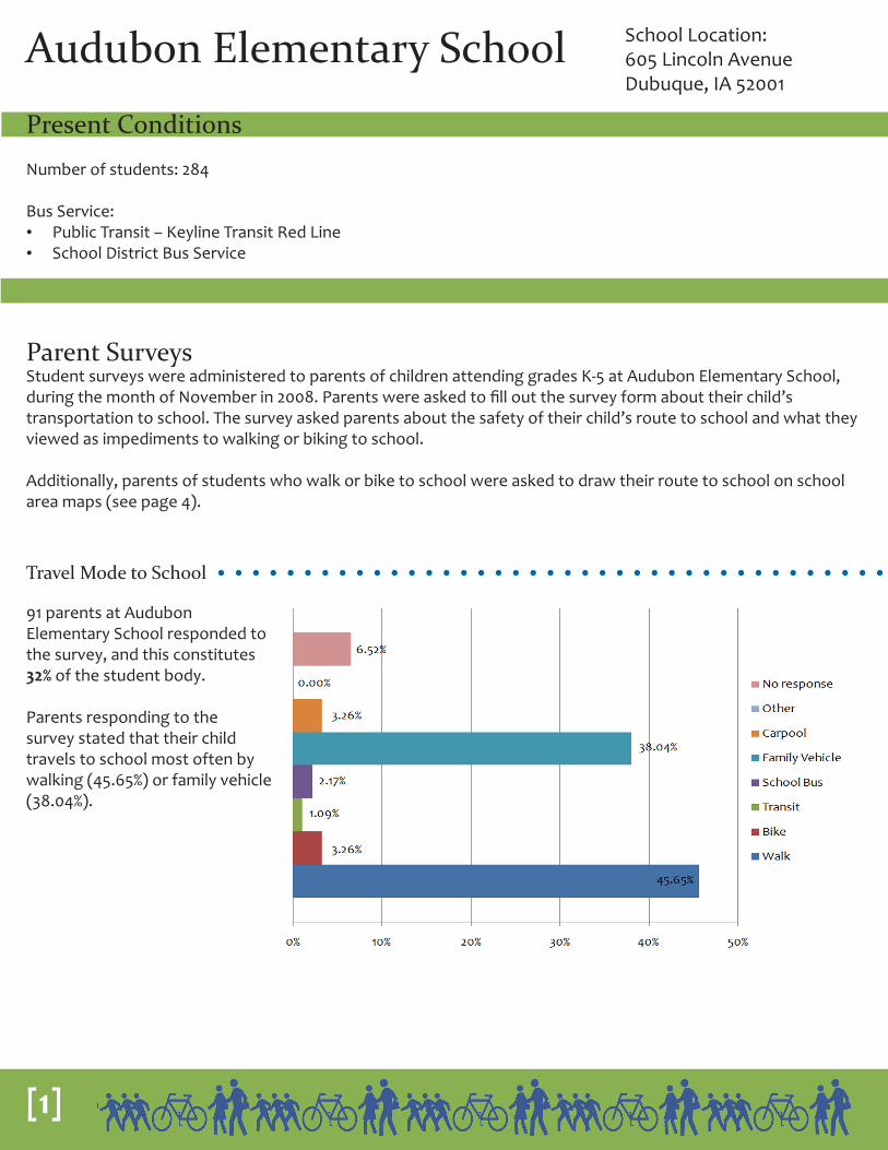
Audubon Elementary School School Location:605 Lincoln AvenueDubuque, IA 52001
Parent SurveysStudent surveys were administered to parents of children attending grades K-5 at Audubon Elementary School, during the month of November in 2008. Parents were asked to fill out the survey form about their child’s transportation to school. The survey asked parents about the safety of their child’s route to school and what they viewed as impediments to walking or biking to school.
Additionally, parents of students who walk or bike to school were asked to draw their route to school on school area maps (see page 4).
Present Conditions
Number of students: 284
Bus Service: • Public Transit – Keyline Transit Red Line• School District Bus Service
91 parents at Audubon Elementary School responded to the survey, and this constitutes 32% of the student body.
Parents responding to the survey stated that their child travels to school most often by walking (45.65%) or family vehicle (38.04%).
Travel Mode to School
[2]
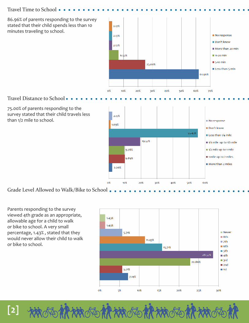
86.96% of parents responding to the survey stated that their child spends less than 10 minutes traveling to school.
75.00% of parents responding to the survey stated that their child travels less than 1/2 mile to school.
Travel Distance to School
Travel Time to School
Grade Level Allowed to Walk/Bike to School
Parents responding to the survey viewed 4th grade as an appropriate, allowable age for a child to walk or bike to school. A very small percentage, 1.43% , stated that they would never allow their child to walk or bike to school.

[3]
Incentives/Programs
The top parent suggestions for increasing walking and biking were:1. Safety Education2. Adult Supervision
The streets cited most often by parents as being unsafe included:1. Windsor Ave. and 22nd St.2. Rhomberg Ave. and Elm St.3. 21st St. and Elm St.4. Jackson St. and 24th St.5. All intersections crossing 22nd St.
The most common changes that would encourage more students to walk or bike to school included less traffic, more desirable weather, and a lower traffic speed.
Environmental Factors Impacting Walking/Biking

[4]
Mapping Student Routes and Crash Data
Those students who walked or biked to school were asked to draw their routes on a provided map. These routes were compiled into Geographical Information Systems (GIS) format. The more heavily used routes began to overlap and become thicker displaying the primary routes used to access schools. This map also contains 2006 crash data from the Iowa Department of Transportation.
9(
!
!
!
!
!
!
!
!
!
!
!!
!
!
!
!
!
!
!
!
!
!
!
!
!
!
!
!
!
!
!
!
!
!
!
!
!
!
!
!
!
!
!
!
!
!
!
!
!
!
!
!
!
!
!
!!
!
!
!
!
!
!
!
!
!
!
!
!
!
!
!
!
!
!
RIES ST
CENTRALAVE
JACKSON ST
E 22ND ST
E 20TH ST
RHOM
BERG
AVE
WASHINGTON
HEEB ST
MAPLE
A STN MAIN ST
17TH ST
E 18TH ST
E 19TH ST
WHITE ST
KNIEST ST
GARFIE
LDAV
E
MADIS
E 21ST ST
W 23RD ST
JOHNSON ST
BERG TERR
FRANCIS ST
SHELBY ST
PEL CT
LINCO
LNAV
E
ARKE DR
GARFIE
LDAV
E
QUEENST
WASHINGTONST
LOWELL ST
THOMAS
PL
E 16TH ST
HEEB ST
MAPLE ST
VALERIA ST
MERZ ST
TH ST
ELM ST
HIGH BL
UFF ST
PINARD ST
STAF
FORD
ST
E 26TH ST
E 25TH ST
FARLEY ST
EAGLE ST
ALTHAUSER ST
MADIS
ON ST
E 21ST ST
PRINCE ST
EDISON ST
HUMBOLDT ST
MARQUETTE PL
VIOLA ST
FENGLER ST
SCHILLER ST
REGENT ST
W 24TH STE 24TH ST
DUBUQU
PLEASANT ST
RHOMBE
ELMST
E 22ND
ST
E 24TH ST
WINDSOR AVE
HENRY ST
ECHT LN
CARR ST
PFOTZER ST
T TERR
RIVE
RVIE
WST
ELMST
N MAIN ST
ANN ST
WASHINGTON ST
CEDARS
STAFFORD ST
EDWARDS ST
ELMST
Student Routes to SchoolAudubon Elementary School
0 500 1,000250 Feet
¯
Data Source: Dubuque SRTS Student Surveys, November 2008, Crash Datafrom Iowa DOT, 2006Map prepared by East Central Intergovernmental Association
9(
School Location ââ ââ ââ ââ ââ ââ Student Bike Route to School
Student Walking Route to School
Lightly Traveled Heavily Traveled
! Crash Location (2006)

[5]
School Administrator Input
Staff met with Audubon School administrators to discuss problems impacting children who walk or bike to school. During these meetings, both structural and educational solutions were discussed. The following table contains the problems and solutions that were listed by Audubon administrators.
Problem Solution1 J-walking on 22nd Street, Lincoln, Rhomberg, Windsor • Traffic signals with quick response during school
arrival and dismissal times at Rhomberg/Johnson and Lincoln/Windsor Crosswalk
2 No ability to staff patrols at 22nd and Windsor or at Johnson and Rhomberg
• Funding sources to staff at unsupervised corners
3 Motor vehicles - lack of awareness and knowledge of how to deal with bicycles and pedestrians
Bicyclists and Pedestrian - lack of awareness and knowledge of how to navigate traffic
• Continue to inform/educate students and parents of safe routes and appropriate safe behaviors traveling to/from school
4 Speeding traffic on 22nd, Windsor, and Rhomberg • Enforcement of existing regulations
5 Parking/congestion on Providence Street • Designated streets near the school as “no parking” or “no parking during school”
6 Potential unseen issues regarding Bee Branch Project • Ongoing- continue dialogue with city officials regarding impact of Bee Branch Project on traffic flow and patterns
7 “Blind” corners at Lincoln and Windsor due to houses with large shrubs at corner

[6]
Audubon Project List
Project lists were developed for each school after holding public meetings and input sessions with school administrators, city planning and engineering staff, and the local police department. The following list outlines projects for Audubon Elementary School.
AudubonInfrastructureReference Number Intersection SuggestionAU1 Rhomberg /Johnson Fully signalized intersectionAU2 Rhomberg /Johnson High visibility painted crosswalkAU3 Lincoln/Windsor Fully signalized intersectionAU4 Lincoln/Windsor High visibility painted crosswalkAU5 22nd/Windsor Fully signalized intersectionAU6 22nd/Windsor High visibility painted crosswalkAU7 Providence between No Parking or No Parking during school hoursAU8 Stafford/Lincoln Adult crossing guards at arrival and dismissalAU9* Lincoln /Humboldt Student crossing guards at arrival and dismissalAU10 Windsor/Rhomberg Curb extensions at 2 or more cornersAU11 Windsor/Rhomberg Flashing school crossing lights at arrival and dismissalAU12 Windsor/Rhomberg High visibility painted crosswalksAU13 Johnson/Rhomberg Curb extensions at 2 or more cornersAU14 19th/Elm High visibility painted crosswalkAU15 20th/Washington Flashing school crossing lights at arrival and dismissalAU16 20th/Washington High visibility painted crosswalkAU17 Rhomberg/Kniest Flashing school crossing lights at arrival and dismissalAU18 Rhomberg/Kniest High visibility painted crosswalkAU19 Lincoln/Windsor Flashing school crossing lights at arrival and dismissal
PolicyNo Reference Number Intersection (if applicable) Suggestion
22nd/Windsor Research funding sources for adult crossing guardsJohnson/Rhomberg Research funding sources for adult crossing guardsLincoln/Windsor Visibility issues due to shrubsProvidence between Windsor and Johnson No Parking or No Parking during school hours
Continued communication between schools and city regarding Bee Branch impacts
Inform/educate students (bicycling and walking) and parents (driving motor vehicles) of safe routes and appropriate safe behaviors traveling to/from school
Lincoln /Humboldt Release students at staggered times based on modeDevelop Neighborhood Safety Team
Safety/Enforcement
No Reference Number Intersection (if applicable) Suggestion22nd St Enforcement of existing speed regulationsWindsor Enforcement of existing speed regulationsRhomberg Enforcement of existing speed regulations
* Listed in multiple categories

[7]
Mapping Audubon Project List
Based on the input received during public meetings and input sessions with school administrators, city planning and engineering staff, and the local police department, the following map was created to provide a visual representation of the projects. Each marker on the map corresponds to an issue in the table on page 6.
9(
!!
!!
!!
!
!
!
!!!
!
!
!!
!!
!
!!
!!
!!
!
!
!
!!
!
!
!
!!
!!
!
Audubon School
AU8
AU13
AU10
AU19
AU17
AU15
AU11
AU7
AU2
AU6
AU4
AU18
AU16
AU14
AU12
AU1
AU5
AU3
AU9
CENTRA
L AVE WH
ITE ST
E 21ST ST
E 22
ND
STJACKSON
ST
RHO
MBE
RG A
VE
E 20TH ST
WINDSOR AVE
E 24TH ST
ELM ST
E 24TH ST
WIN
DSOR AVE
LINCO
LN A
VE
ELM ST
WASHIN
GTO
N ST
KNIEST ST
QUEEN
ST
GAR
FIELD
AVE
WHITE ST
E 21ST ST
PRINCE ST
E 19TH ST
REGEN
T ST
PRO
VIDE
NCE
ST
JOHNSON STPINARD ST
STAFFORD ST
MAPLE S
T
E 22
ND S
T
HIG
H BL
UFF
ST
THO
MAS
PL
STAFFORD
WINDSOR AVE
HEEB ST
ELM ST
WASHING
TON ST
ELM ST
STAFFORD STStudent Routes to School
Audubon Elementary School
0 200 400100 Feet
¯
SRTS Projects
!! Painted Crosswalks
!! Signalized Intersection
!! Flashing Crossing Lights
!! Curb Extensions
!! No Parking
!! Adult Crossing Guards
!! Student Crossing Guards
9(
School Location ââ ââ ââ ââ ââ ââ Student Bike Route to School
Student Walking Route to School
Lightly Traveled Heavily Traveled
Data Source: Dubuque SRTS Student Surveys, November 2008Map prepared by East Central Intergovernmental Association