Embed Size (px)
Citation preview
Attachment B
Instructions for Using the Web Viewer Tool for the VTD/BBSP Verification
Version 1 January 2010

Table Of Contents I. INTRODUCTION..................................................................................3 II. ACCESS, LOGIN, AND SELECT COUNTY TO VERIFY .............3
A. Accessing the Web Viewer Tool. ..................................................................... 3 B. Program Login .................................................................................................. 4 C. Selecting the County (or County Equivalent) to Verify ................................... 5
III. TOOLS ....................................................................................................6
A. Tool Symbols and Definitions. ........................................................................ 7 B. Specific Information for Selected Tools. ......................................................... 8
1. Previous Map Extent...................................................................................... 8 2. Get Information.............................................................................................. 8 3. Measure Distance......................................................................................... 11 4. Print a Map................................................................................................... 13 5. Email a Map ................................................................................................ 14
IV. LINKS ................................................................................................... 15
A. Legend............................................................................................................ 16 B. Layers............................................................................................................. 17
1. Views ............................................................................................................ 18 2. Suffix............................................................................................................. 19
C. Dataview ......................................................................................................... 21 D. Selection.......................................................................................................... 25 E. Changes ........................................................................................................... 26
Instructions for Using the Web Viewer Tool for the VTD/BBSP Verification 2
I. INTRODUCTION
During the verification phase of the Voting District/Block Boundary Suggestion Project (VTD/BBSP) participants may verify their data using the Web Viewer tool. The Web Viewer tool allows participating states to review the VTD/BBSP submission in a Web-based environment without the need of installing additional software. Participants may access the Web Viewer using a Web browser. The Web Viewer tool does not support an edit function. Any corrections to the Census Bureau’s data required as a result of the verification review must be conducted using the MAF/TIGER Partnership Software (MTPS). See Attachment C: Instructions for Using the MTPS for Verifying the VTD/BBSP Submission for detailed instructions. Note that minor or small corrections resulting from the verification of the VTD/BBSP submission using the Web Viewer tool can be discussed with the respective Regional Census Center (RCC) to enter the correction. (See Attachment A: RCC Geographic Staff Contact Information for contact information.) An example of a correction that can be communicated for the RCC staff to fix is changing the VTD cover for a small face or two. Minor or small corrections can be conveyed to the RCC staff to preclude submitting a RDP “change” file using the MTPS. II. ACCESS, LOGIN, AND SELECT COUNTY TO VERIFY Follow these guidelines for accessing the tool and entering the correct login information. A. Accessing the Web Viewer Tool
In order to access the Web Viewer tool, go to: http://ecots1.geo.census.gov/mtpsmaps/ The following screen appears.
Instructions for Using the Web Viewer Tool for the VTD/BBSP Verification 3
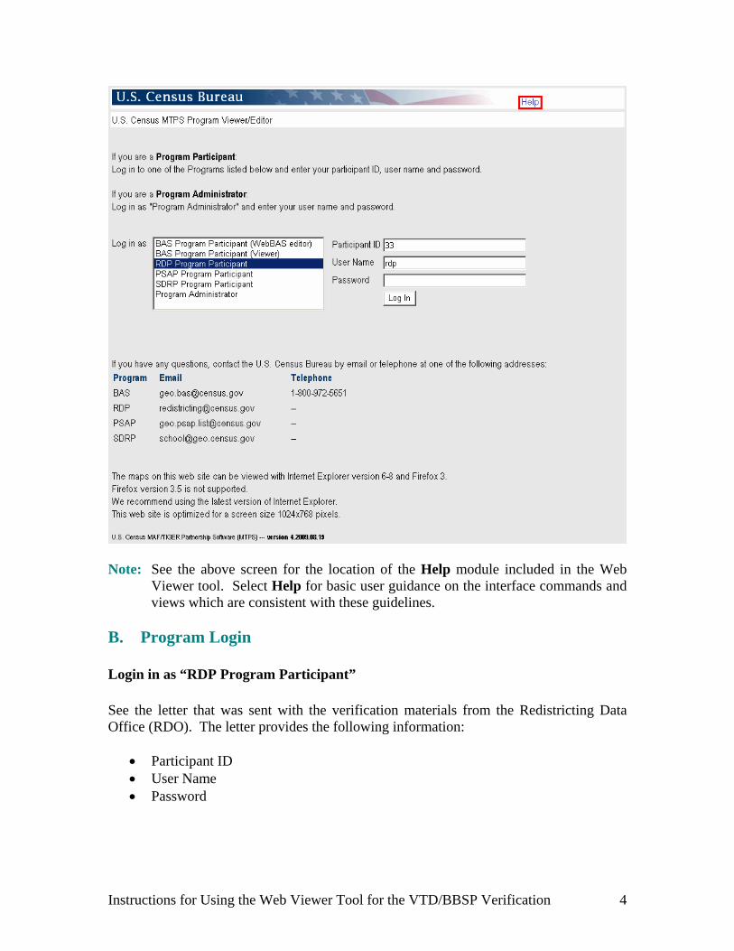
Note: See the above screen for the location of the Help module included in the Web
Viewer tool. Select Help for basic user guidance on the interface commands and views which are consistent with these guidelines.
B. Program Login Login in as “RDP Program Participant” See the letter that was sent with the verification materials from the Redistricting Data Office (RDO). The letter provides the following information:
Participant ID User Name Password
Instructions for Using the Web Viewer Tool for the VTD/BBSP Verification 4

C. Selecting the County (or County Equivalent) to Verify After logging in as the RDP Program Participant (example for New Hampshire, ST:33), the Web Viewer returns a menu listing all counties in the selected state.
Select to identify which county (or county equivalent) will be reviewed. For example, select Belknap County, NH to begin the verification. The Web Viewer displays the selected county.
Instructions for Using the Web Viewer Tool for the VTD/BBSP Verification 5

To select a different county, select List Counties (top/left) to return to that screen. III. TOOLS Use the Web Viewer toolbox for navigation, information and measurement as shown (outlined in red) in the graphic above.
Instructions for Using the Web Viewer Tool for the VTD/BBSP Verification 6
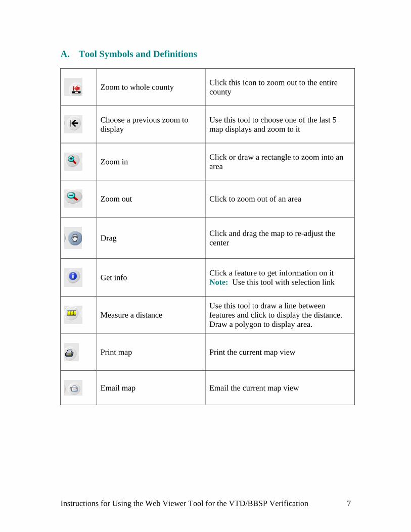
A. Tool Symbols and Definitions
Zoom to whole county Click this icon to zoom out to the entire county
Choose a previous zoom to display
Use this tool to choose one of the last 5 map displays and zoom to it
Zoom in Click or draw a rectangle to zoom into an area
Zoom out Click to zoom out of an area
Drag Click and drag the map to re-adjust the center
Get info Click a feature to get information on it Note: Use this tool with selection link
Measure a distance Use this tool to draw a line between features and click to display the distance. Draw a polygon to display area.
Print map Print the current map view
Email map Email the current map view
Instructions for Using the Web Viewer Tool for the VTD/BBSP Verification 7
B. Specific Information for Selected Tools
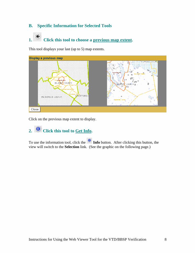
1. Click this tool to choose a previous map extent. This tool displays your last (up to 5) map extents.
Click on the previous map extent to display.
2. Click this tool to Get Info.
To use the information tool, click the Info button. After clicking this button, the view will switch to the Selection link. (See the graphic on the following page.)
Instructions for Using the Web Viewer Tool for the VTD/BBSP Verification 8
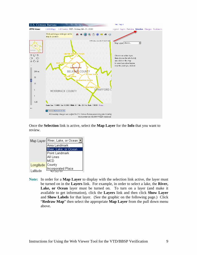
Once the Selection link is active, select the Map Layer for the Info that you want to review.
Note: In order for a Map Layer to display with the selection link active, the layer must
be turned on in the Layers link. For example, in order to select a lake, the River, Lake, or Ocean layer must be turned on. To turn on a layer (and make it available to get information), click the Layers link and then click Show Layer and Show Labels for that layer. (See the graphic on the following page.) Click “Redraw Map” then select the appropriate Map Layer from the pull down menu above.
Instructions for Using the Web Viewer Tool for the VTD/BBSP Verification 9
Instructions for Using the Web Viewer Tool for the VTD/BBSP Verification 10
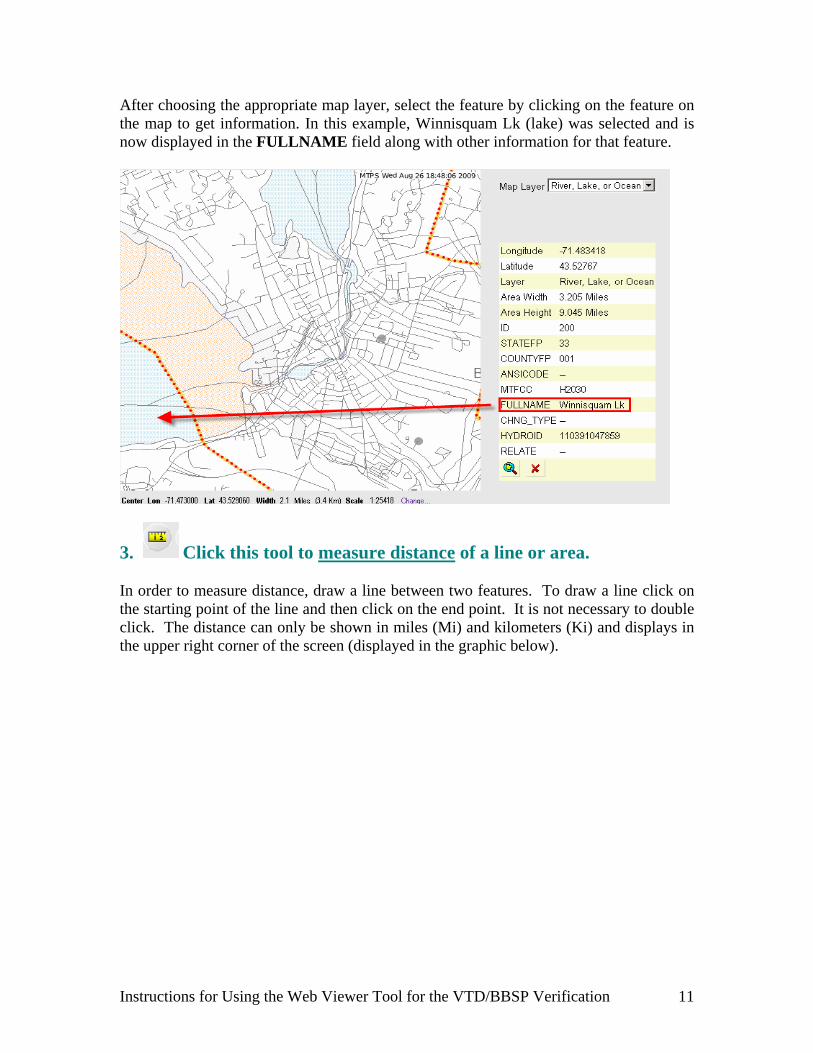
After choosing the appropriate map layer, select the feature by clicking on the feature on the map to get information. In this example, Winnisquam Lk (lake) was selected and is now displayed in the FULLNAME field along with other information for that feature.
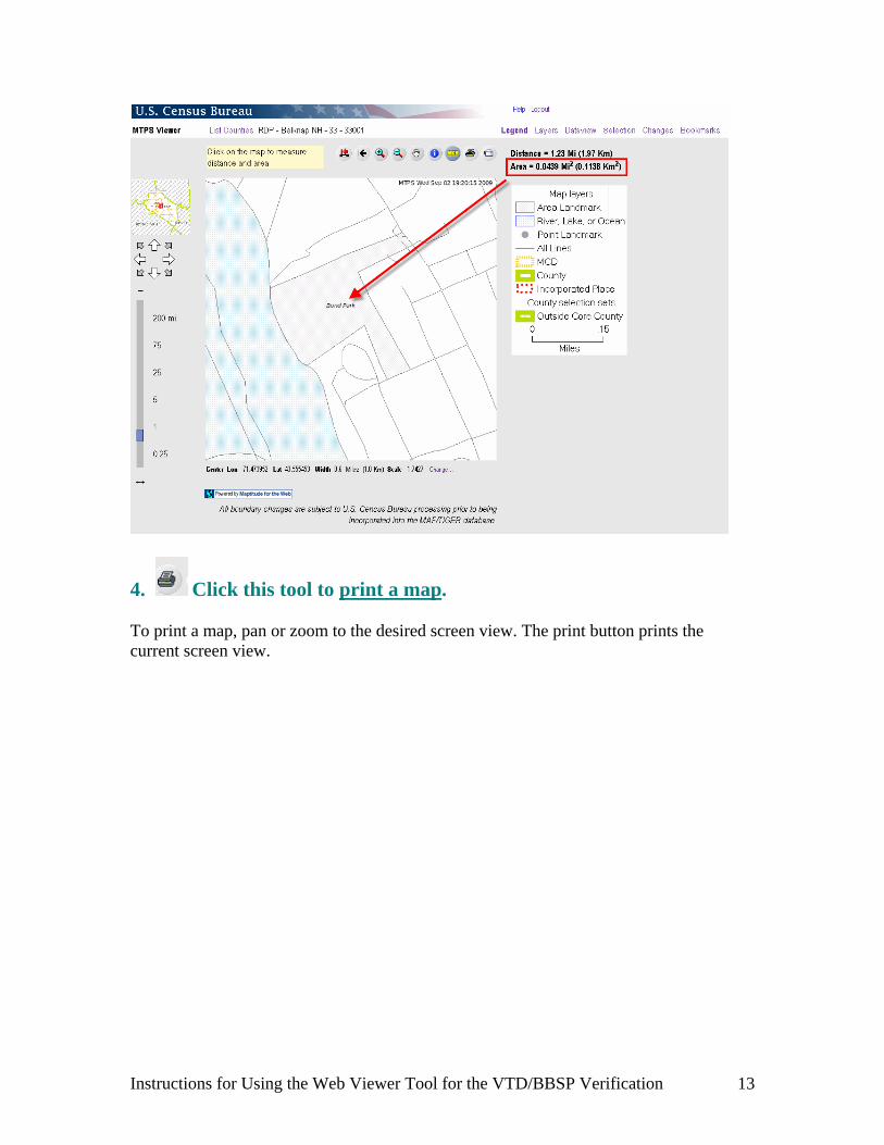
3. Click this tool to measure distance of a line or area. In order to measure distance, draw a line between two features. To draw a line click on the starting point of the line and then click on the end point. It is not necessary to double click. The distance can only be shown in miles (Mi) and kilometers (Ki) and displays in the upper right corner of the screen (displayed in the graphic below).
Instructions for Using the Web Viewer Tool for the VTD/BBSP Verification 11

Double-click to disengage a line measurement and measure any new line. To measure an area (such as Bond Park in the following example), trace a polygon by clicking on each turn (point). Double click to close the polygon. The area displays in the right corner (displayed in the second graphic below).
Instructions for Using the Web Viewer Tool for the VTD/BBSP Verification 12
4. Click this tool to print a map. To print a map, pan or zoom to the desired screen view. The print button prints the current screen view.
Instructions for Using the Web Viewer Tool for the VTD/BBSP Verification 13
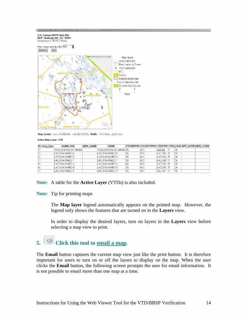
Note: A table for the Active Layer (VTDs) is also included. Note: Tip for printing maps
The Map layer legend automatically appears on the printed map. However, the legend only shows the features that are turned on in the Layers view.
In order to display the desired layers, turn on layers in the Layers view before selecting a map view to print.
5. Click this tool to email a map. The Email button captures the current map view just like the print button. It is therefore important for users to turn on or off the layers to display on the map. When the user clicks the Email button, the following screen prompts the user for email information. It is not possible to email more than one map at a time.
Instructions for Using the Web Viewer Tool for the VTD/BBSP Verification 14

Be certain to provide relevant information in the comment text box. Communicate the specific reason for sending the map. IV. LINKS The Links settings are located on the top right-hand corner of the Web Viewer as displayed in the graphic below.
Instructions for Using the Web Viewer Tool for the VTD/BBSP Verification 15
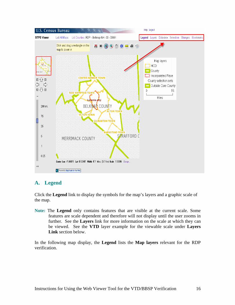
A. Legend Click the Legend link to display the symbols for the map’s layers and a graphic scale of the map. Note: The Legend only contains features that are visible at the current scale. Some
features are scale dependent and therefore will not display until the user zooms in further. See the Layers link for more information on the scale at which they can be viewed. See the VTD layer example for the viewable scale under Layers Link section below.
In the following map display, the Legend lists the Map layers relevant for the RDP verification.
Instructions for Using the Web Viewer Tool for the VTD/BBSP Verification 16

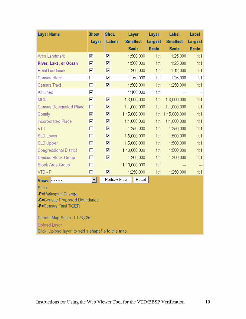
Set these Map layers in the Layers link. B. Layers Use the Layers link to control the features to display and label. Turn layers on and off by checking and un-checking layer boxes.
Instructions for Using the Web Viewer Tool for the VTD/BBSP Verification 17
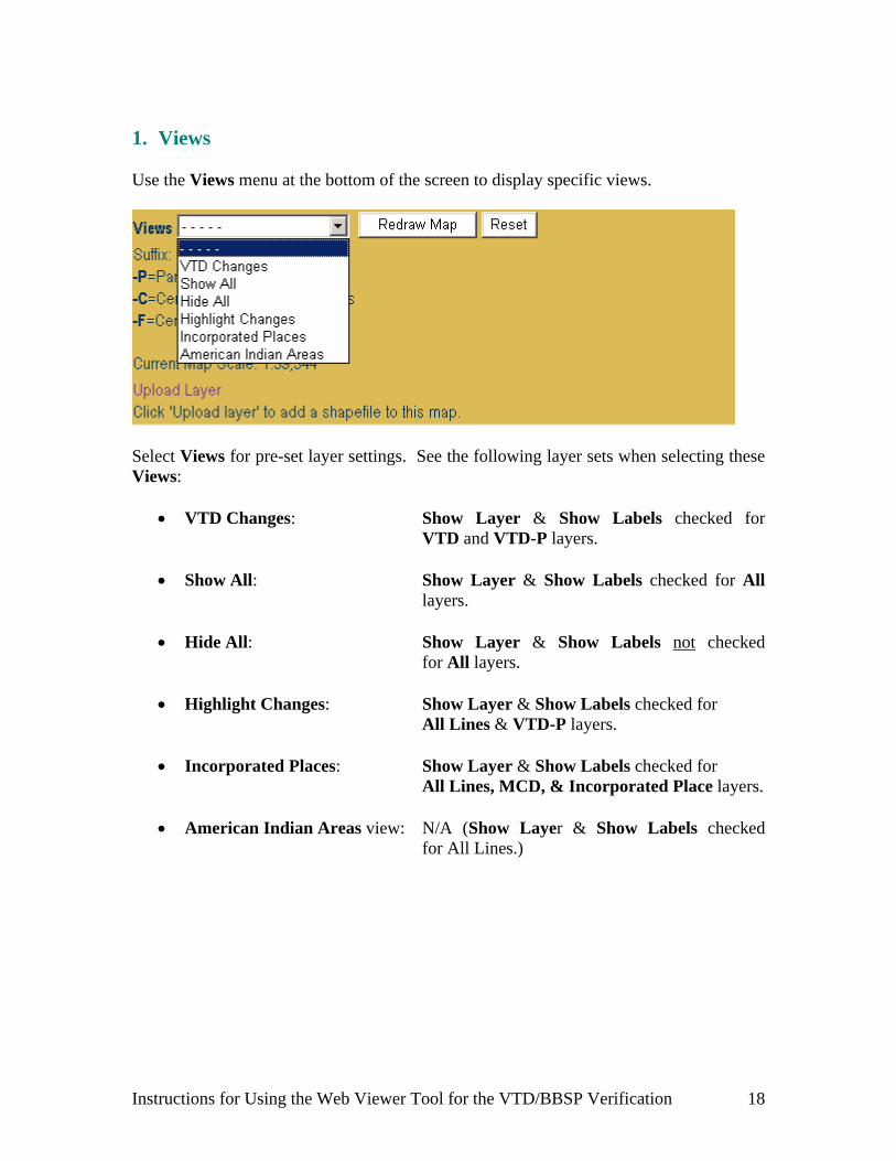
1. Views Use the Views menu at the bottom of the screen to display specific views.
Select Views for pre-set layer settings. See the following layer sets when selecting these Views:
VTD Changes: Show Layer & Show Labels checked for VTD and VTD-P layers.
Show All: Show Layer & Show Labels checked for All
layers. Hide All: Show Layer & Show Labels not checked
for All layers. Highlight Changes: Show Layer & Show Labels checked for All Lines & VTD-P layers. Incorporated Places: Show Layer & Show Labels checked for All Lines, MCD, & Incorporated Place layers. American Indian Areas view: N/A (Show Layer & Show Labels checked
for All Lines.)
Instructions for Using the Web Viewer Tool for the VTD/BBSP Verification 18
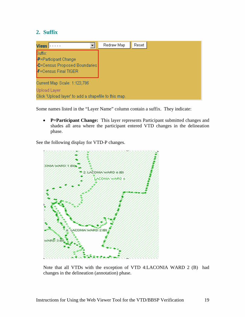
2. Suffix
Some names listed in the “Layer Name” column contain a suffix. They indicate: P=Participant Change: This layer represents Participant submitted changes and
shades all area where the participant entered VTD changes in the delineation phase.
See the following display for VTD-P changes.
Note that all VTDs with the exception of VTD 4:LACONIA WARD 2 (B) had changes in the delineation (annotation) phase.
Instructions for Using the Web Viewer Tool for the VTD/BBSP Verification 19
Note: No VTDs display as changes if the participant did not use the MTPS for delineation.
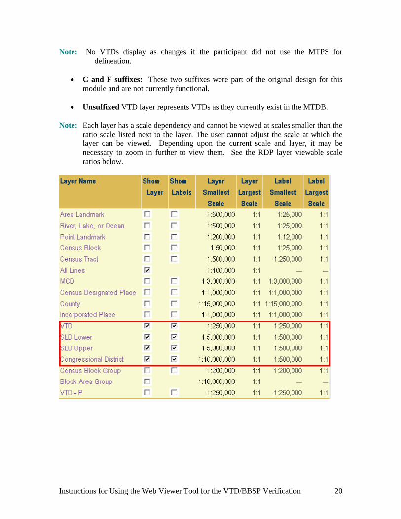
C and F suffixes: These two suffixes were part of the original design for this
module and are not currently functional. Unsuffixed VTD layer represents VTDs as they currently exist in the MTDB.
Note: Each layer has a scale dependency and cannot be viewed at scales smaller than the ratio scale listed next to the layer. The user cannot adjust the scale at which the layer can be viewed. Depending upon the current scale and layer, it may be necessary to zoom in further to view them. See the RDP layer viewable scale ratios below.
Instructions for Using the Web Viewer Tool for the VTD/BBSP Verification 20

Redraw Map when turning a layer on or off.
Upload Layer: Select this to add a “local” shapefile to this map. The following text box
appears.
Browse to the local folder of the shapefile to upload. Enter a Name for the shapefile layer to upload to the map. Select Upload.
Note: The file must include three files: .SHP, .SHX and .DBF) to be uploaded and added.
C. Dataview Use the Dataview link for zooming into a specific layer or viewing a complete list of a certain feature or entity type.
Instructions for Using the Web Viewer Tool for the VTD/BBSP Verification 21

For example, select VTD from the Dataview Layer in order to see a list of all VTDs in the county.
Click the Zoom icon to zoom in to the VTD. The Viewer zooms to and displays the selected VTD. This is useful in reviewing the VTD names and codes.
Instructions for Using the Web Viewer Tool for the VTD/BBSP Verification 22
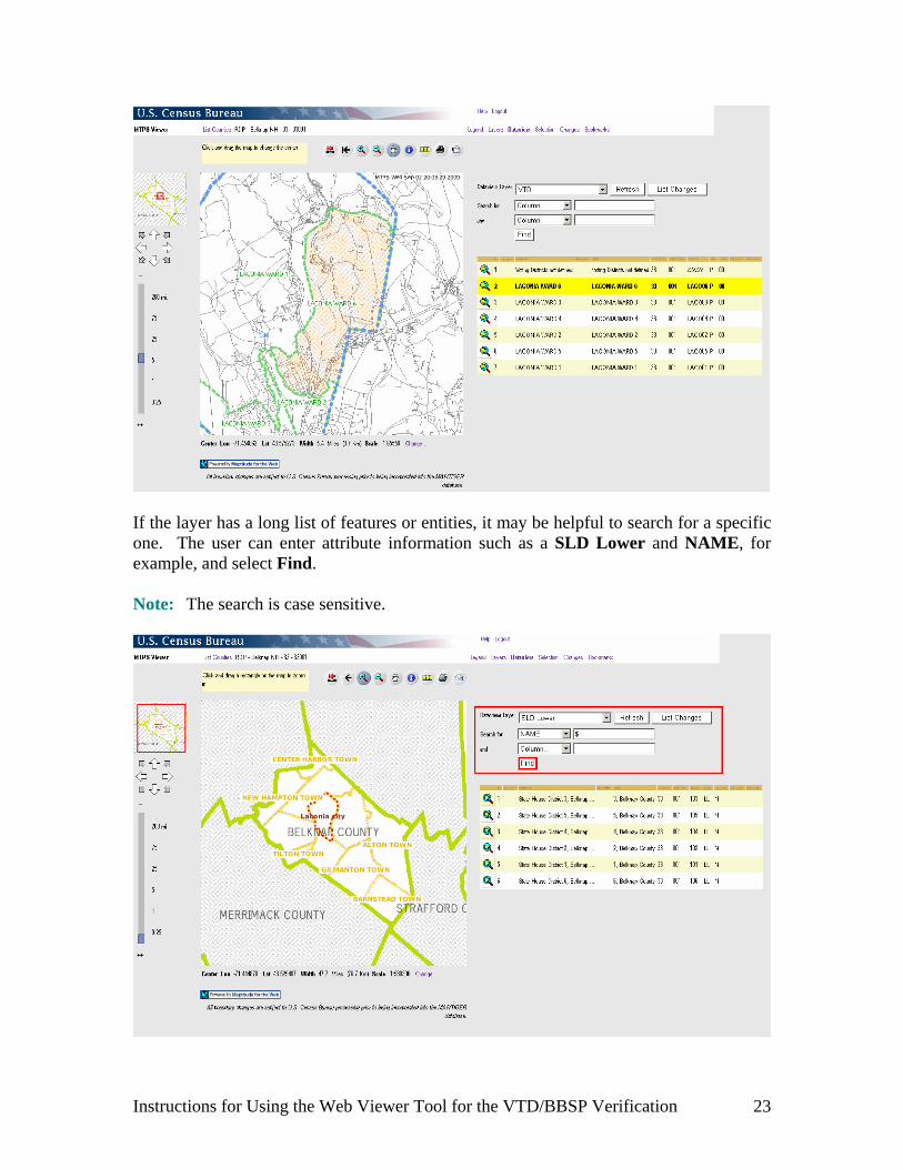
If the layer has a long list of features or entities, it may be helpful to search for a specific one. The user can enter attribute information such as a SLD Lower and NAME, for example, and select Find. Note: The search is case sensitive.
Instructions for Using the Web Viewer Tool for the VTD/BBSP Verification 23

Now select the Zoom icon to zoom in to the searched entity, example SLDST 104.
The Web Viewer zooms and displays the entity of the search. Note: Once the user has used the Dataview link to select a searched entity or feature,
use the Info tool to get more information about the entity, as demonstrated for an SLD Lower example below.
Instructions for Using the Web Viewer Tool for the VTD/BBSP Verification 24
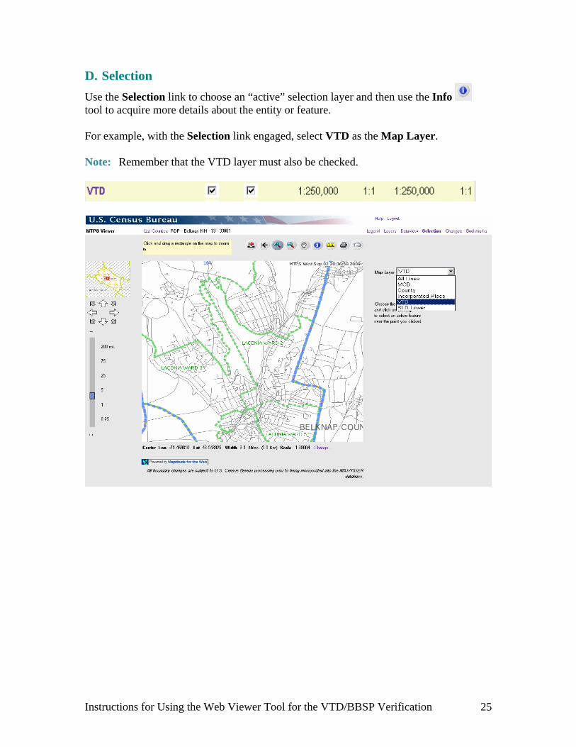
D. Selection
Use the Selection link to choose an “active” selection layer and then use the Info tool to acquire more details about the entity or feature. For example, with the Selection link engaged, select VTD as the Map Layer. Note: Remember that the VTD layer must also be checked.
Instructions for Using the Web Viewer Tool for the VTD/BBSP Verification 25
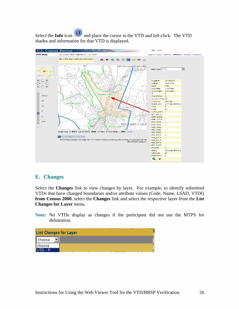
Select the Info icon and place the cursor in the VTD and left-click. The VTD shades and information for that VTD is displayed.
E. Changes
Select the Changes link to view changes by layer. For example, to identify submitted VTDs that have changed boundaries and/or attribute values (Code, Name, LSAD, VTDI) from Census 2000, select the Changes link and select the respective layer from the List Changes for Layer menu. Note: No VTDs display as changes if the participant did not use the MTPS for
delineation.
Instructions for Using the Web Viewer Tool for the VTD/BBSP Verification 26
Instructions for Using the Web Viewer Tool for the VTD/BBSP Verification 27
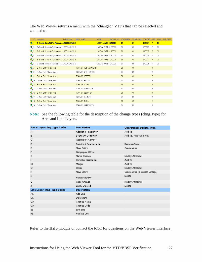
The Web Viewer returns a menu with the “changed” VTDs that can be selected and zoomed to.
Note: See the following table for the description of the change types (chng_type) for
Area and Line Layers.
Refer to the Help module or contact the RCC for questions on the Web Viewer interface.