Embed Size (px)
Citation preview

.r0r"")ti_on.~ackag~~
L . Section
Manager
Attachment #1
The Corporation of THE CITY OF NORTH VANCOUVER ENGINEERING, PARKS & ENVIRONMENT DEPARTMENT
INFORMATION REPORT
To: Mayor Darrell R. Mussatto and Members of Council
From: Dragana Mitic, Assistant City Engineer, Transportation
SUBJECT: NORTH SHORE AREA TRANSIT PLAN
Date: September 29,2010 File No: 1180-37-07
ATTACHMENTS:
1. North Shore Area Transit Plan Summary, TransLink.
2. Transit Strategy, Long Term Transportation Plan, 2008.
PURPOSE:
The purpose of the report is to update Council on the commencement of the North Shore Area Transit Plan (NSATP).
BACKGROUND:
The previous NSATP was completed in December 2000. That plan included transit system improvements over three to five years. With significant changes occurring in the City and the region in past few years, complemented with the GHG reduction requirements, it is critical to update this plan and develop transit service improvements that would increase sustainable transportation choices and help us achieve our GHG emission targets.
In the past, Council expressed support for working with TransLink on the planning of the transit service in the City and was looking forward to the start of the NSATP process.
INFORMATION REPORT: North Shore Area Transit Plan Date: September 29,2010 Page 1 of3

STUDY PROCESS/TIMElINE:
In July, TransLink commenced the NSATP process to review and analyze the performance of the existing transit network, create a long-term network vision for both transit services and infrastructure, and identify priorities. TransLink estimated that this
. will be an 18 month project, engaging various stakeholders and general public, concluding in fall 2011. The plan consists of four phases:
• Phase I - Analysis of the Network • Phase II - Visioning • Phase III - Setting Priorities and • Phase IV - Reporting Back
Attachment 1 provides an overview of the study process.
TransLink will work in close partnership with the five North Shore municipalities (City of North Vancouver, District of North Vancouver, District of West Vancouver, Bowen Island and Lions Bay), First Nations and other key stakeholders.
Presently, TransLink is creating a Public Advisory Committee that will offer advice and suggestions during the course of the consultation process and development of the plan. This group will consist of five representatives from the North Shore municipalities (one representative from each), representatives from the First Nations, and one representative for the following areas: transit user, senior, youth, bike, road advocate, and accessibility. The City's representative will be selected from the Advisory Planning Commission (APC) considering their role advising on transportation issues in the City. As well, an invitation to apply for the position of a specific user has been forwarded to
. the members of the Joint Bicycle Advisory Committee, the Parks and Environment Advisory Committee, the North Shore Advisory committee on Disability Issues and the Social Planning Advisory Committee for their consideration. TransLink staff are scheduled to make a presentation on this study to APC on October 13,2010.
In addition, a stakeholders group will be formed including various businesses, agencies, resident and business associations.
Staff will provide regular updates to Council on the progress of this work and at significant milestones invite TransLink to present findings.
CORPORATE PLAN AND/OR POLICY IMPLICATIONS:
For the City, improved transit is one of the most important means to encourage people to reduce driving and help us in our efforts to reduce greenhouse gas emissions. The City relies on improvements to the regional and North Shore transit system in order to introduce various other transportation programs in the City that would increase walking, cycling and transit modes. The Long-Term Transportation Plan outlines transit strategy components and desired system improvements to increase ridership and customer satisfaction (Attachment 2).
INFORMATION REPORT: North Shore Area Transit Plan Date: September 29, 2010 Page 2 013
11 Ii tl 1
I' kl
! " I , I i i
1".'1 , I I
~

The coordination of transit with land use planning is a fundamental aspect of sustainable planning. It is therefore timely that this work will occur immediately following the adoption of the Metro Regional Growth Strategy and during our own OCP update process. Population and employment growth- needs to be aligned with transit service and vice versa. Bicycles and walkability are integral to this as well.
In the Community Energy and Efficiency Plan, improved transit access through increased frequency and coverage of service, increased number of high-speed and inter-city routes, phased in natural gas and electric drive vehicles has been identified as very important to achieve GHG reduction targets. Sensitivity analysis completed as part of this study indicated that increased service over Burrard Inlet would be the most effective action for the transportation sector, either as an extension of the Canada Line or a 3rd SeaBus complemented with increased local transit service in 2020.
The main transit system improvements identified through these two studies are:
a. Addition of a 3rd SeaBus/or extension of Canada Line complemented with the increased local transit service;
b. Expansion I Improved East-West service and overall City coverage;
c. I ncreased bus depot capacity;
d. Upgrades to the SeaBus terminal & Phibbs Exchange; and
e. Increased bike capacity on buses.
Approximately fifty percent of the City's green house gas emissions come from transportation sources. Therefore, it is necessary to find ways to address transportation emissions in order to achieve the City's and Province's reduction targets. An aggressive approach to transit improvements is an essential component to reduce GHG emissions, their negative effect on climate change, and ensure the liveability of our community for the long term. An efficient and enhanced transportation system that provides effective and convenient alternatives to single occupancy vehicles is key in making progress.
RESPECTFULLY SUBMITTED:
INFORMATION REPORT: North Shore Area Transit Plan Date: September 29, 2010 Page 3 of 3

North Shore Area Transit Plan Summary June 2010
Attachment #1
TransLink has now begun the process of developing the North Shore Area Transit Plan (NSATP). The Area Transit Plan will establish a long term transit vision, including both transit services and infrastructure, and identify the shorter term priorities to begin achieving such a network The implementation of the Plan should result in a transit networl< with increased efficiency, effectiveness, and transit mode share. An ATP is a key input to TransLink's annual 3 Year Plan & Outlook for Years 4-10.
Area Transit Plans acknowledge regional differences and seek input from local stakeholders, residents, and transit and non-transit users. For the NSATP, TransLink will analyse the current network and develop a future network based .on transit performance findings, community input, land use and population growth. The Plan will consider transit needs around the North Shore and important connections across the Burrard Inlet. The ATP is also an opportunity to review the scale, design and location of transit exchanges, including how they relate to current or proposed developments.
The ATP can also assist in the coordination of transit with municipal policy and decision-making. The ATP provides more detail on TransLink's direction specific to the North Shore than higher-level plans such as the 3 Year Plan & 10 Year Outlook and Transport 2040. Annual monitoring and reporting of the ATP results will ensure ongoing visibility of the plan, as well as allow for refinement of priorities as the communities develop.
The previous NSATP was completed in December 2000. Most projects identified in the five year implementation plan were completed . The new NSATP will be completed by the Fall of 2011.
Phase One: Summer & Fall 2010 TransLink will analyse the efficiency and effectiveness of the current transit networl<, fleet and facilities, looking at ridership, population, employment and land use. This work includes community and stal<eholder
identification of key issues with the current service and infrastructure.
Phase Two: Winter 2011 Through community consultation, this phase of the plan will develop a long term vision (2040) for the North Shore's transit network.
Phase Three: Spring - Fall 2011 Phase Three will establish and rank the priorities to begin implementing the vision, and will consider the timing of relationships between service changes and required infrastructure improvements. Priorities will then be implemented on an annual basis as funding is identified through TransLink's rolling 3 Year Plan, and through ongoing local government communications to ensure the continued validity of the priorities ranking.
Phase Four: Fall 2011 - Ongoing A final component of the NSATP involves implementation of the priorities identified, along with ongoing monitoring and reporting on the North Shore transit network. This also allows for an opportunity to review the plan priorities as communities develop in the future.
I
I I I I
N
*t 1: " E ..r::
~ 0(
. no ~ C <>1"OIn'I<VA.l\lCOU~ur
.~e Long-Tenn Plan
Pedestrian Plan
BimteP/aa
Tnnsit Strategy 1. Improved Accessibility to
Transit
3. Expanded Frequent Transit Network:
4. Transit Priority Treatments 5. Expanded U-Pass Program
and Potential Resident Pass Program
6. Expanded SeaBus Service and Enhance Tenninal
Road Network Plan
Goods andSerykes MOllementStrateay
TOM Strategy
URB1tNSYSTEMS.
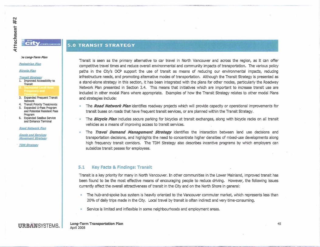
5.0 TRANSIT STRATEGY
Transit is seen as the primary altemative to car travel in North Vancouver and across the region, as it can offer competitive travel times and reduce overall environmental and community impacts of transportation. The various policy
paths in the City's OCP support the use of transit as means of reducing our environmental impacts, reducing
infrastructure needs, and promoting altemative modes of transportation. Although the Transit Strategy is presented as
a stand-alone strategy in this seCtion, it has been integrated with the plans for other modes, particularly the Roadway
Network Plan presented in SeCtion 3.4. This means that initiatives which are important to increase transit use are
included in other modal Plans where appropriate. Examples of how the Transit Strategy relates to other modal Plans
and strategies include:
• The Road Network Plan identifies roadway projects which will provide capacity or operational improvements for transit buses on roads that have frequent transit services, or are planned within the Transit Strategy.
• The Bicyde Plan includes secure parking for bicycles at transit exchanges, along with bicycle racks on all transit
vehicles as a means of improving access to transit services.
• The Travel Demand Management strategy identifies the interaCtion between land use decisions and
transportation decisions, and highlights the need to concentrate higher densities of mixed-use developments along
high frequency transit corridors. The IDM Strategy also describes incentive programs by which employers can
subsidize transit passes for employees.
5.1 Key Facts & Findings: Transit
Transit is a key priority for many in North Vancouver. In other communities in the Lower Mainland, improved transit has
been found to be the most effeCtive means of encouraging people to reduce driving. However, the following issues
currently affect the overall attraCtiveness of transit in the City and on the North Shore in general:
• The hub-and-spoke bus system is heavily oriented to the Vancouver commuter market, which represents less than
20% of daily trips made in the City. Local travel by transit is often indirect and very time-consuming.
• Service is limited and inflexible in some neighbourhoods and employment areas.
Long-Term Transportation Plan April 2008
45

• Overcrowding is an issue on specific routes during peak periods.
• Buses are generally inconvenient and costly for most trips and are affected by congestion, so are not competitive
with car travel to encourage behavioural change in support of the City's goals.
• There are no direct bus services from the City across the Ironworkers Memorial Bridge to Burnaby and Vancouver,
and few direct bus services to post-secondary institutions throughout the region.
• The bus depot is at capacity, affecting the ability to provide reliable accessible transit with bicycle racks on buses.
• Many bus stops in the City are inaccessible for pecple using mobility aids.
• There is no significant park-and-ride facility on the North Shore to support commuters wishing to combine driving
and transit forlonger-distance commutes.
• The existing Lonsdale Quay terminal lacks appeal and amenities to attract tourists and make them feel welcome,
and general concerns about personal safety and security at terminals are a deterrent to using transit.
5.2 External Initiatives
TransUnk owns, plans, and funds transit facilities and services in the Oty of North Vancouver and throughout Greater
Vancouver. The TransUnk Board approved an Area Transit Plan for the North Shore in 2001 that called for
improvement to transit services in the City and District of North Vancouver, the District of West Vancouver, the Village
of Uons Bay and Bowen Island Municipality. Improvements identified in this plan were prioritized over a five year time frame. As that time frame has now expired, TransUnk plans to begin work on an update to the North Shore Area
Transit Plan in 2008.
5.3 The City's Long-Term Transit Strategy
46
The purpose of the Transit Strategy is to confirm support for many planned transit enhancements in the City and
identify other desired improvements to increase ridership and customer satisfaction. To be more sustainable, transit
must continue to attract a growing proporton of travel external to the North Shore and become much more attractive
Long-Tenn Transportation Plan April 2008
The Long-Tenn Plan
Pedestrian Pllln
Bicyclt: Plan
Transit Stratggy 1. Improved Accessibility to
Transit
3. Expanded Frequent Transit Net'NOrk
4. Transit Priority Treatments 5. Expanded U-Pass Program
and Potential Resident Pass Program
6. Expanded SeaBus Service and Enhance Terminal
Road Network PliM
Goods and Servia~s MovrmtMt Strategr
TOM Strateav
URBANSYSTEMS.

~':'--''''''--~
The Long-Tenn Plan
Pedestrian Plan
Bicycle PlIIO
Traf1tit Strategy 1. Improved AccessIbility to
Transit
3. Expanded Frequent Transit Network
4. Transit Priority Treatments S. Expanded U-Pass Program
and Potential Resident Pass Program
6. Expanded SeaBus service and Enhance Terminal
Road Network Plan
GDDdS "nd &trvias Movement Str«teov
TO", Strategy
URBA"NSYSTEMS.
for getting around tile tIlree communities. The recommended long-term transit services, facilities and support programs may be implemented by TransUnk, the City of North Vancouver, or other agencies and employers.
1. Improved Accessibility to Transit
Increased accessibility to tranSit is designed to enhance services and facilities for all existing customers and to attract
new riders. Today, many individuals experience barriers to using transit for various reasons ranging from the physical
What does the Transit Strategy Include?
1. Improved Accessibility to Transit
2. Increased Local Area Frequency and
Coverage
3. Expanded Frequent Transit Network.
4. Transit Priority Treatments
5. Expanded U-Pass Program and Potential
Resident Pass Program
6. Expanded SeaBus Service and Enhance
Terminal
challenges of system elements (such as accessing stops and stations) through to tIlose that experience cognitive ·difficulties getting around on transit. In 2007, TransUnk approved the recommendations of tile Access Transit Project,
which was designed to create "a seamless and indusive public transit system that welcomes members of the Region's diverse communities with a fully integrated range of bus, rail, ferry and custom transit services that is inviting, responsive, safe, comfortable, and affordable; and that meets the needs of our customers to access transit vehides,
information, customer seNice, training, and other programs_ H The core recommendations of tile Board described below largely involve the overarching direction of TransUnk, but require munidpal support to bolster accessibility standards
and practices.
Establish Access Transit Office & Users' Advisory Committee to provide a single point of contact to work with custom transit users and others transit customers to monitor system accessibility, review unresolved
issues, and evaluate system performance.
• Provide Better Customer Support that goes beyond redudng physical barriers, to giving customers dear
information tIlat is easy to find, signage they can easily understand, and support from front-line staff in order to use transit successfully. Initiatives such as enhancements to the website, directional signage, customer outreach and specialized training for transit users and staff will make the system more accessible for everyone.
Within the City, improved on-street signage to key transit nodes will enhance customer access.
• Improve Access to Transit Fadlities to support a seamless experience for customers on tile adjacent street system leading toward transit facilities, riding on transit fieets and using otller transit fadlities such as stations
Long-Term Transportation Plan April 2008
47

48
and exchanges. TransUnk has developed Universal Accessibility Guidelines for transit vehides and fadlities to
set a standard for all future investments in fleets and fadlities. The City of North Vancouver will increase
accessibility of bus stop fad lities and as well as the pedestrian system, induding sidewalks and crossings.
• Increase Availability of Effective Custom Transit by altering the operation and management of HandyDART in order to improve the quality of the service, provide a seamless regional custom transit service
and to better integrate custom transit with the overall transit system.
• Improve Safety and Security at Main Transit Exchanges such as Lonsdale Quay to help ensure the
safety and comfort of passengers and increase transit ridership.
2. Increased Local Area Frequency and Coverage
The Transit Strategy recommends increasing local area frequency and coverage with conventional and small bus services through additional fleet and service hours. With the provision of other support programs and fadlities, these
long-term service expansions highlighted below will be designed to provide more attractive connections within the City
and with other North Shore communities (see Map 4).
• Direct services across the northem areas of the North Shore (i.e. Queen Street/29'" Street) to connect with Capilano College.
• Services across the northern edge of Central Lonsdale (i.e. 16'" Street, Larson Road and 23'" Street) to Lynn Valley.
Central Lonsdale and Lower Lonsdale neighbourhood services in order to provide transit coverage and attractive connections for residents to the Lonsdale commercial areas as well as other frequent transit services ..
• Explore options for a free shuttle service along the Lonsdale corridor.
• Expanded service to Harbourside Auto Mall area.
• Neighbourhood service connections to 1" Street industrial and business area.
Long-Term Transportation Plan April 2008
, .~
- "lilt C ""1tOClloI ~ ..... CO";\fUl
The Long-Tenn Plan
Pedeftndn Plan
Bicycle PliO
Transit Strdteav 1. Improved Accessibility to
Transit
3. Expanded Frequent Transit Networ1t
4. Transit Priority Treatments 5. Expanded U-Pass Program
and Potential Resident Pass Program
6. Expanded Sea8us Service and Enhance Terminal
Road Network Plan
Goods and Services Movement Strdtr:qy
roM StriJteoy
URBANSYSTEMS.

, , • ,
'" 0: .
"'. 0: -u, ", "'~
>
" j , ,
" ", «~ •. 1$t~r" LL.
-27th Sf
~~ ", 1
g3rd Sf
~
>
" • • ~
-"
• • •
Map 4: Proposed Transit Coverage I City ~f ;~&iliLVancouver Transport~tion Plan
•
>
" " > ~ " 0 " 11 • • ~ G
13th SI
<i'"e"';'q
"'0' • . "' ,
/:>' ~ ~ I-." rJ
~ •. ~ ..... _ 2'1h St
'" "
e&t$-' .. 0
LEGEND - Existing conventional service
Potential conventional service
- Frequent transit network
..... Possible connections
1_ - Hwy1 -.. ... ---.-:.-- « ... » Potential nelghbourhood transit connection
> >
" " • • • • E> ~ 0 • ~ " <;; <;;
I
I
23r.d St
>
" ~ • ~
.~
1-9th St
<
17th Sf
13th Sf
11th Sf
9th St
>
" f
LOVi
L.evel R~ ........ """ ... -.-........ -_ ....
Interregional
Neighbourhood service area
City boundary Notte scale
--' ., I .. "
~, e. ~
URBA"NSYSTEMS, April 2008

',,.,,-.-..,..- , . ..,~
50
3 . Expand the Frequent Transit Network
The Transit Plan supports expanding the Frequent Transit Networl< on the North Shore along three primary corridors (see Map 4). Within the 2008 Transportation and Finandal Plan, TransUnk has identified a range of primary roads in Greater Vancouver - such as Marine Drive - where the service levels will be or are already operating at least every 15 minutes, 15 hours per day and 7 days per week. These corridors may be served using conventional bus services, express ·services or Bus Rapid Transit. In the long-term, the City will want to plan for an expanded frequent transit
network to increase ridership and promote densification along the following corridors:
• Lonsdale Avenue from Queens Street to Esplanade
• Marine Drive between 15'" Street in West Vancouver through to capilano College
• Marine/Keith/IS'" services to augment the local services providing a direct connection between Parl< Royal and Central Lonsdale.
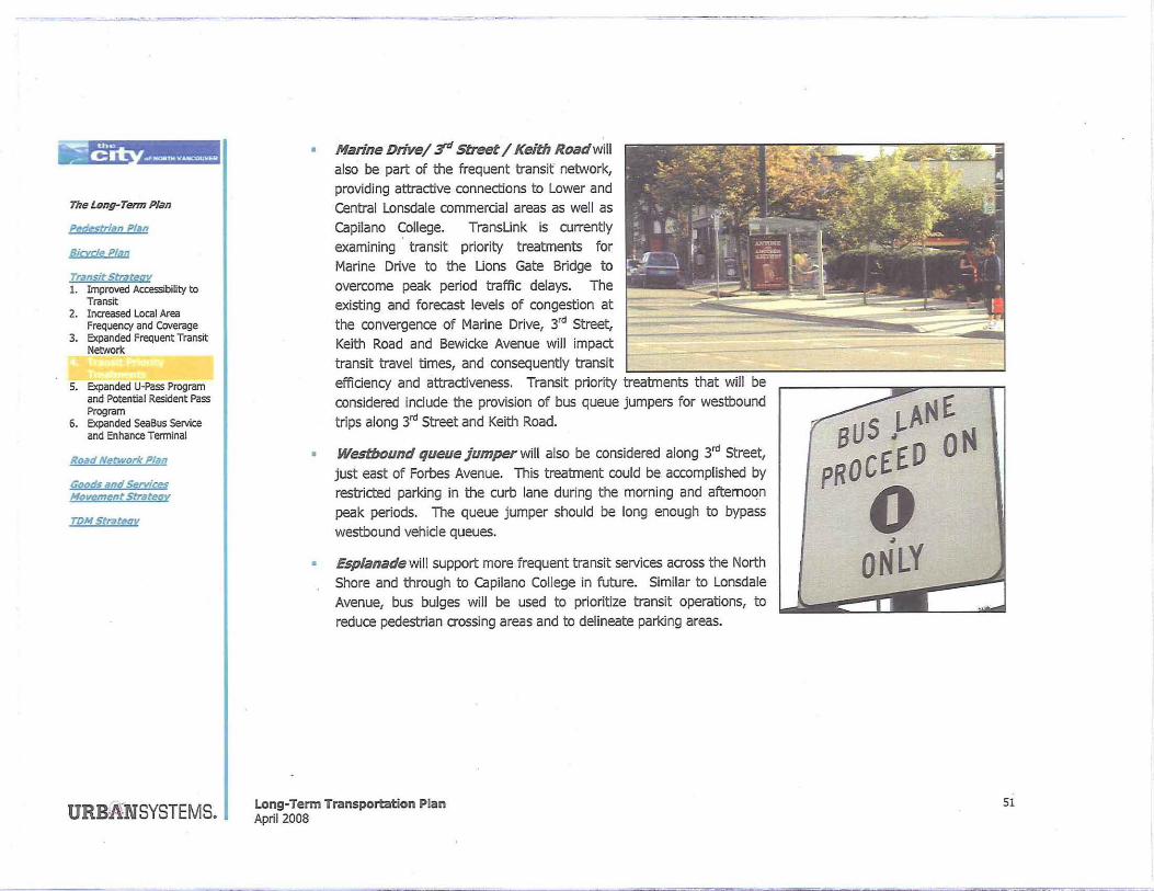
4. Implement Transit Priority Treatments
Transit Priority Treatments are recommended along each of the Frequent Transit Network corridors. Where delays and congeston exist today or antidpated to get worse in future, the City will examine opportunities for priority treatments that reduce delays to bus services. These treatments indude, but are not limited to signal coordination, bus bulges, intersection queue jumpers and dedicated bus lanes. These Transit Priority Treatments will improve service for transit,
often at the expense of vehides. Although many of these treatments will impact vehicles, they are key to supporting long·term transit ridership by prioritizing transit over vehicles. The planned transit priority improvements described in the Roadway Network Plan are briefiy highlighted as follows:
Lonsdale Avenue (23'" to Esplanade) is identified as part of the frequent transit network in order to serve the two key commerdal districts of the City. In order to minimize delays to transit vehicles and to improve the customer experience with enhanced transit stop amenities, bus bulges are recommended at most stop
locations. Bus bulges will reduce delays to transit vehicles having to move over to the curb areas between parked vehicles on the street and then merge in with the traffic fiow. Overall, this will reduce transit travel times and increase the competitiveness of transit travel. With the provision of bus bulges and other curb extensions to reduce pedestrian crOSSings, the coordination of signal timing along Lonsdale will be refined to enhance north-south travel time for buses.
Long-Term Transportation Plan April 2008
The Long~Term Plan
&destrian Plitn
Bicyde Plan
Trans;t Strategy , 1. Improved Accessibility to
Transit 2. Increased Local Area
Frequency and Coverage
5. Expanded U-Pass Program and Potential Resident Pass Program
6. Expanded SeaBus Service and Enhance Terminal
RDdd Nfttwork Plan
Goods and SrlVicl!s Movement SCrdtegy
rpM Strategy
URB1t'NSYSTEMS.
;w:.:;
'hv
:"' C .. t ......... .,.-. .. ~g.
The Long-Term Plan
Ped§trian Plan
Bicyde P1itn
Transit Strategy 1. Improved Accessibility to
Transit 2. Increased Local Area
Frequency and Coverage 3. Expanded Frequent Transit
Network
5. Expanded U-Pass Program and Potential Resident Pass Program
6. Expanded SeaBus Service and Enhance Tenninai
Road Network Plan
GoodfilndServices Hovementstrdtegy
roN Strategy
URBttNSYSTEMS.
Marine Drivel :r' Street I Keith Roadwill also be part of the frequent transif network, providing attractive connections to Lower and Central Lonsdale commercial areas as well as Capilano College. TransLink is currently examining transit priority treatments for Marine Drive to the Lions Gate Bridge to overcome peak period traffic delays. The existing and forecast levels of congestion at the convergence of Marine Drive, 3,d Street, Keith Road and Bewicke Avenue will impact transit travel times, and consequently transit efficiency and attractiveness. Transit priority treatments that will be considered include the provision of bus queue jumpers for westbound trips along 3"' Street and Keith Road.
Westbound queue jumper will also be considered along 3'd Street, just east of Forbes Avenue. This treatment could be accomplished by restrcted parking in the curb lane during the morning and afternoon peak periods. The queue jumper should be long enough to bypass westbound vehicle queues.
• Esplanade will support more frequent transit services across the North Shore and through to Capilano College in future. Similar to Lonsdale Avenue, bus bulges will be used to prioritize transit operations, to reduce pedestrian crOSSing areas and to delineate parking areas.
Long· Term Transportation Plan April 2008
BUS .LANE PROCEED ON
o •
ONLY ___ ~'i
51

52
5. Expanded U·Pass Program and Potential for Resident Pass Program
The City is supportive of initiatives to expand the U-Pass Program to Capilano College. Today, the Vancity U-Pass program is a joint program between TransUnk, post secondary inStitutions and student societies. The program places a transit pass in the hand of each student as a mandatory program at each partidpating inStiMion - currentiy at SFU and USc. In 2008, TransUnk will work with Capilano College through a student referendum to implement the U-Pass
program. Based on the experience of other schools, this initiative will significantly increase transit ridership and reduce driving trips, consequently minimizing congeStion on the roadway network.
The City will also work with TransUnk to examine the potential of resident pass programs along the frequent transit network corridors - such as Marine Drive and Lonsdale Avenue. In core areas of the City where attractive transit services are already or planned to be in place, resident transit pass programs may be possible for new or exiSting developments to reduce impacts on the roadway network - similar to UniverCity at SFU. In such cases, new
developments would be required through the development approvals process to provide transit passes for each unit. Similar to the U-Pass program, a resident pass program would require high participation levels in order to make the reduce pass cost feasible. TransLink and the City would need to monitor usage patterns and perhaps make adjustments
to service levels as demands rise.
6 . Expanded Sea Bus Service and an Enhanced Terminal
Expanding the SeaSus Service and enhancing the terminal will dramatically improve transit service to Downtown Vancouver and connections to other rapid transit networks that serve other areas of the Lower Mainland, including the Vancouver International Airport. Today, the existing vehicles can carry up to 400 passengers, making four trips per hour in each direction in the peak periods. In 2009, TransLink is expecting delivery of a third SeaSus that will increase
the capacity of the exiSting service by 50% between Lonsdale Quay and Downtown Vancouver. Once acquired, the new SeaBus will be utilized as a replacement for the exiSting vessels which are in need of dry dock maintenance. With
the increased crossing capacity, bus services to the Londsdale Quay will be increased as previously described, and improvements to the North Vancouver 5eaBus Terminal will be required to enhance passenger amenities and increase personal security.
Long-Term Transportation Plan April 2008
The Long-Term Plan
Pl!destrian PIli" 2.
Bicycle PI;Jn
Transit Strategy 1. Improved Accessibility to
Transit 2. Increased local Area
Frequency and Coverage 3. Expanded Frequent Transit
Network 4. Transit Priority Treatments
ROad Network P/;m
Goods and Sfrviqs MovementStriftegy
TPM Strategy
URB:A'NSYSTEMS.


![Attachment Revision[1]](https://img.pdfslide.us/doc/110x75/577d22e01a28ab4e1e987840/attachment-revision1.jpg)


![Attachment Disorder[1]](https://img.pdfslide.us/doc/110x75/577d39531a28ab3a6b998cb8/attachment-disorder1.jpg)