Embed Size (px)
Citation preview
" 'A.tffIINfiTO~ HEOLOGH 'AL HURYEY
HENRY LA;NDI~S, State Geologh,t
BULLETIN No. 18
By MORR.LS )I. Ll~rHH'l'ON
OL\'11\PIA
FRANK lll. t,'1\JBORN a@,o PUBI.JC l'RINTER.
1918

,/
A .. "'\
' '=>.. -.;
"'-
BOARD OF GEOLOGICAL SURVEY
Governor ERXEST L ISTE:R, Cltairmccn. Lieutenaut Go~ernor Loms F. HART.
State Tre,1sm·er W . "\V. SrrnRl\fAN, Secretary. President HEKlIY SuzZALLO.
President Eu_sBsT 0. HOLLAND.
llixar L.rnDEi'>, 8/atf' Geologist.
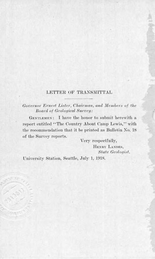
LErrTER OF TRANS~IITTAL
Govf'rno r Ernesf Lis/er, Chairman, and Jif·111uers of the Boa rd of G<'olo.rtical S'U rwy :
GEKTLEMEN : I haYe the honor to submit herewi th a report entitled II The Country A botTt Camp Lewis," with tJ1e recommendation that it he printed as Bulletin Ko. 18 of the m:vey repor ts.
Ve1y respectfully, HENRY LAN'ffE.',
State Geolo.r;ist. UniYcrsity Shltion, Seattle, .July J , ]91 8.
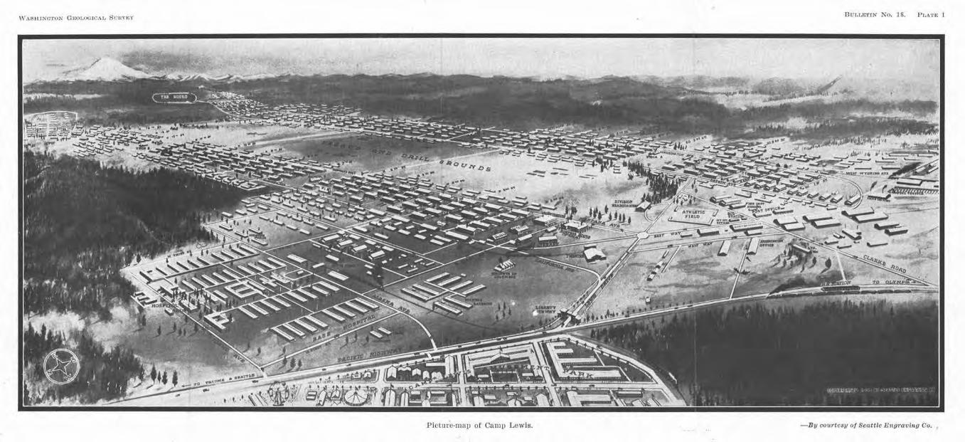
Picture-map Of Camp Lewis.
But,1,trrlN No. IS. l'1,,,·rE 1
I Seattle E11gravlnu Co. - Bv courte81J o
TABLE OF CONTENTS.
Page
PREFACE 8
CHAPTER I. C,u1r Lt:wrs AXO V1c1:-.nY......................... 9 The Cantonment . . . . . . . . . . . . . . . . . . . . . . . . . . . . . . . . . . . . . . . . . . . . 9 The Carup . . . . . . . . . . . . . . . . . ... . . . . . . . . . . . . . . . . . . . . . . . . . . . . . . . 10 Trans110rtation Facilities_ . . . . . . . . . . . . . . . . . . . . . . . . . . . . . . . . . . . . l1 Cities near the Cantonment. . . . . . . .. . . . . . . . . . . . . . . . . . . . . . . . . . . 11
Tacoma . . . . . . . . . . . . . . . . . . . . . . . . . . . . . . . . . . . . . . . . . . . . . . . . . . 11 Seattle ........................ ·. .......................... 11 Olym1lta . . . . . . . . . . . . . . . . . . . . . . . . . . . . . . . . . . . . . . . . . . . . . . . . . l 2
CHAPTER n. Tin: SrRFACE Fi-:ATt' Ri-:,s oF WEsTr.1<x WAsmxuTox A;,10 o~· TIH; CA~ll' LEWIS CA;,;TOX\ffXT................... 14
The OJ)rmplc Mountains...................................... 14 The Willapa Hills . . . . . . . . . . . . . . . . . . . . . . . . . . . . . . . . . . . . . . . . . . . ln The Cascade Mountain Range................................. 16
Mt. Rainier . . . . . . . . . . . . . . . . . . . . . . . . . . . . . . . . . . . . . . . . . . . . . . 16 The Resources of the Cascades......... . ................... 1T
The Puget Sound Basin. . . . . . . . . . . . . . . . . . . . . . . . . . . . . . . . . . . . . . 18 General Characte1 . . . . . . . . . . . . . . . . . . . . . . . . . . . . . . . . . . . . . . . . 18 An Old Drainage System. . . . . . . . . . . . . . . . . . . . . . . . . . . . . . . . . . 20
Topography of tl1e Camp Lewis Cantonment................... 20 Drainage . . . . . . . . . . . . . . . . . . . . . . . . . . . . . . . . . . . . . . . . . . . . . . . . . 21 \.Vater-Supplies . . . . . . . . . . . . . . . . . . . . . . . . . . . . . . . . . . . . . . . . . . . 23 Sanitation . . . . . . . . . . . . . . . . . . . . . . . . . . . . . . . . . . . . . . . . . . . . . . . 24 Road Conditions . . . . . . . . . . . . . . . . . . . . . . . . . . . . . . . . . . . . . . . . . 24 Military Uses . . . . . . . . . . . . . . . . . . . . . . . . . . . . . . . . . . . . . . . . . . . . 25
CHAPTER III. Tin: 011101:-. ot· TUE Mol' XTAIX R.,xm-:;; .,:,1) OF nu: Peot::-r Sopxn BAs1;,. . . . . • . . . . . • . . . . . . . . . . . . . • . • . . . . . . • . 26
The Cascade Range. . . . . . . . . . . . . . . . . . . . . . . . . . . . . . . . . . . . . . . . . . 26 Mount Rainier and other Similar Peaks.................... 29
The Olympic Mountains . . . . . . . . . . . . . . . . . . . . . . . . . . . . . . . . . . . . . 30 The Puget Sound Basin....................................... 30
CHAPTER TV. 'l'nE Cr,ui,,•rr-; ot' CA,\11' Li-:w1s..................... 33 Temperature . . . . . . . . . . . . . . . . . . . . . . . . . . . . . . . . . . . . . . . . . . . . . . . . 33
Temperature Records at Tacoma........................... 34 Comparison or Temperature Condillons at lhe Dil'!'erent Can-
tonments . . . . . . . . . . . . . . . . . . . . . . . . . . . . . . . . . . . . . . . . . . . . . 34 EtTects of Oniformlly of Winter Temperature on the HealLh
of the Camp . . . . . . . . . . . . . . . . . . . . . . . . . . . . . . . . . . . . . . . . . . 38 Eastward Limitations or Western Washington's Climate..... 39
The Rainfall of Western Washington................... . . . . . . . 39 Source of the Rains.................... . . . . . . . . . . . . . . . . . . . 39 Rainfall l\fap . . . . . . . . . . . . . . . . . . . . . . • . . . . . . . . . . . . . . . . . . . . . 40 Seasonal Differences . . . . . . . . . . . . . . . . . . . .. . . . . . . . . . . . . . . . . . 40 LocaJ DitTerences . . . . . . . . . . . . . . . . . . . . . . . . . . . . . . . ... . . . . . . . 42 Rainfall at other Cantonments . . . . . . . . . . . . . . . . . . . . . . . . . . . . 43 Snowfall . . . . . . . . . . . . . . . . . . . . . . . . . . . . . . . . . . . . . .. . . . . . . . . . . 44 Sultry Weather . . . . . . . . . . . . . . . . . . . . . . . . . . . . . . . . . . . . . . . . . . 44 Wind Velocity . . . . . . . . . . . . . . . . . . . . . . . . . . . . . . . . . . . . . . . . . . . 46 Sunshine . . . . . . . . . . . . . . . . . . . . . . . . . . . . . . . . . . . . . . . . . . . . . . . . 46 Comparison or the Climate of Camtl Lewis with tbat. of
France and Belgium.................................... 47
6 Table of Contents
Paye
CHAPTER V. AXOJJ-:NT Cr,IMATLC C1-LA1'\GE::;......... . ............. 51 Former Period of T ropical Climate . .. . . . . ........... . ...... .. . 51 Glacia l Climate . . . . . . . . . . . . . . . . . . . . . . . . . . . . . . . . . . . . . . . . . . . . . 52
Source of the P uget Sound Glacie r . . . . . . . . . . . . . . . . . . . . . . . . 52 Soutbe.rn Limi ts or Glaciation... . ......................... 54-T h ickuess of the Ice. . . . . . . . . . . . . . . . . . . . . . . . . . . . . . . . . . . . . . 54 The Retreat of the Glacier . . . . . . . . . . . . . . . . . . . . . . . . . . . . . . . . 54
Construction of the Gravel P la in and B ills ot the Cantonment.. 56 Orig in of the Lakes............... . ....................... 60
Other Glacial Epochs......................................... 61 Length of Time S ince the last Glaciation............... . ...... 61
CHAPTER V I. H u~JAX H 1,:;TonY or nu; CAMP LEW IS RF.01ox...... 63 By Ecl,nond S. Meany.
CHAPTER VII. Non:s ox P .LAX'1' s Fouxo 1.\' THE V101:nTY OF CA::ltP L 1,wr;:;. By George B. 'Rigg. . . . . . . . . . . . 7-1
The Trees of the Hills...... .. . . ........................ . ..... ,-1. The Forest Undergrowth ....... . . . . . . . . . . . . . . . . . . . . . . . . . . . 75 Taller S hrubs . . . . . . . . . . . . . . . . . . . . .. . . . . . . . . . . . . . . . . . . . . . . 76 Smaller Shr ubs . . . . . . . . . . . . . . . . . . . . . . . . . . . . . . . . . . . . . . . . . . 77 \Voody Vines . . . . . . . . . . . . . . . . . . . . . . . . . . . . . . . . . . . . . . . . . . . . 79 Herbaceous Plants . . . . . . . . . . . . . . . . . . . . . . . . . . . . . . . . . . . . . . . 80
The P rairies . . . . . . . . . . . . . . . . . . . . . . . . . . . . . . . . . . . . . . . . . . . . . . . . 83 Camp Lewis P lants . . . . . . . . . . . . . .. . . . . . . . . . . . . . . . . . . . . . . . . . . . 85
Forests ............ . ... : . . . . . . . . . . . . . . . . . . . . . . . . . . . . . . . . . 85 Prairies . . . . . . . . . . . . . . . . . . . . . . . . . . . . . . . . . . . . . . . . . . . . . . . . . 87
CHAPTER vrrr. T in : RELATrON 0 1' TT.LE Gt,OLO(lY 0~' WES'l'l':111" WA.S1[-
JNG1'0N TO MEASl1llES OT•' l'\1JT.ITARY DEF!sXSt: ............... 92 Western Washington as a P rize of Conquest................. . . 92 Probability of Attack on Puget Sound . . . . . . . . . . . . . . . . . . . . . . . . . 93 Natural Defenses or Washington .... . . . . . . . . . . . . . . . . . . . . . . . . . . 94 Strategic Routes of Attacl, . . . . . . . . . . . . . . . . . . . . . . . . . . . . . . . . . . . 9i
'fh e Strait of J uan de F uca and Admiralty Inlet.... . . . . . . . . 97 Climatic Factors ......................................... 101 The Grays Harbor and Chehalis Valley Gateway ........... . 102 T he Columbia River-Cowli tz Valley Route ............. . . . .. 104 Columbia River , through the Cascade Gorge, to the Columbia
Plateau . . . . . . . . . . . . . . . . . . . . . . . . . . . . . . . . . . . . . . . . . . . . . . . 10~ Summary and General Conclusion ..... . ........ .. . ...... . .. .. 105
ILLUSTRATIONS.
Faci11g Pr..A'l'ER P(iQC
I. Picture-map of Camp Lewis............................... 1
II. A relief map of Washington showing the major topographical features . . . . . . . . . . . . . . . . . . . . . . . . . . . . . . . . . . . . . . . . . . . . . 8
III. The Olympic Mountains as seen from Puget Sound....... . . 18
IV. Scene in the Cascade Mountain Range..................... 26
V. Mount Rainier from Paradise Park........................ 36
VI. Sunset View across Puget Sound. . . . . . . . . . . . . . . . . . . . . . . . . . 44
VU. View of the Paclflc Highway and the level topogratlhY north· east of Camtl Lewis........ . .......................... 54
VIII. American Lake . . . . . . . . . . . . . . . . . . . . . . . . . . . . . . . . . . . . . . . . . . 64
IX. View of the edge of the Fir Forest or the Gravel Plain near Camp Lewis . . . . . . . . . . . . . . . . . . . . . . . . . . . . . . . . . . . . . . . . . 72
X. A virgin forest In Western Washington..... .. ... . . . . . . . . . . 80
XI. Ship construction in one of the Puget Sotmd Shipyards.... 90
XII. View of the Columbia River Gorge, from Mitchell Point.... 98
FHHJRES Pauc
1. Map showing the geograph'lcal position of Camp Lewis......... 10
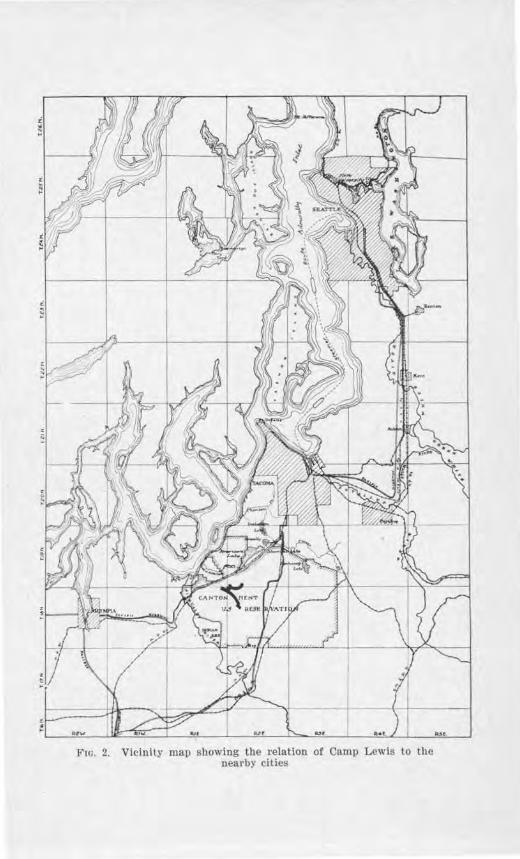
2. Vicinity map showing the relation of Camp Lewis to the near-by cl ties . . . . . . . . . . . . . . . . . . . . . . . . . . . . . . . . . . . . . . . . . . . . . . . 13
3. Rainfall map, showing the monthly precipitation, in inches. in different parts of the state.. ... ......................... 41
4. Comparative map of the northwestern states and of France and Belgium, showing their positions by latitude............. 48
5. Sketch map showing the extent o( the glaciation of the Puget Sound Region . . . . . . . . . . . . . . . . . . . . . . . . . . . . . . . . . . . . . . . . . . 63
6. Diagram showing the positions of the ice front when the gravelplain of the Camp Lewis Cantonment was made.......... 67
PREFAC:1£
The situation of the Camp Lewis Cautonmcnt is scenic, strategic, and historical. It possesses an enYironment of mounta in, plain, and water; a· position with all the necessary qualities for a land base; and a location in tbc \'icinity of the :first American setuemcnt in the Northwest. Consistent with the national ideals of education, tho Board of Geological Survey of Washington has authorized the publication of this bulletin dealing with the e things.
The aim has been to include the topics of chief interest, without attempting to g ive a complete history, and to make the account void of technical discussions.
The writer has drawn very largely on the work of Director George Otis Smith, of the . S. Geological Survey, Professor Bailey ·wrnis, of Leland Stanford, Jr., University, and Dr. Chas. E. Weaver, of the Un:iYersity of Washington, for the broad outlines in the geological history of the r egion; on the work of Dr. J. Harlan Bretz, of the University of Chicago, for the glacial history; on the reports by Professor E .• J. Sauuders, of tbe Unfrersity of Washingto11, for the climate; and on various bulletins of tho . S. ,Veather Bureau for weather record . Acknowledgment is hereby given to all scientific workers concerned.
Many courtes ies were shown by Brigadier-General Foltz; :Major F . W . Manley, Division Adjutant; Lieutenant-Colonel Ehrnbeck of the 316th Engineers; Captain Wm. R. White of the Quartermaster Department; -:\fajor ,John G. Strohm of the Medical Corps; Professor N. F . Coleman, Educational Secretary of the Y. )I. C. A.; and l\fr. L. 0. Fisher of the U. S. vYeather Bureau. To these the ·wTiter e).1Jresses his appreciation and thanks.
Especially grateful is the writer to Professor Edmond S. Meany, :Mr. Victor J. Farrar, and Dr. George B. Rigg, all of t1rn University of Washingto11. Professor :Meany and :Mr. Farrar prepared the exce11ent chapter on human history, and Professor Rigg the authoritative chapter on the plants in the Yicini ty of Camp Lewis.
MORRIS l\f. L EIGHTON.
WASHINGTON GF-OT..OGICAL S 0 11VEY B ULt,F,T[N No. 18 Pr.ATE ll
A relief ma.P of Washington showing the major topographic features. Scale, about 44 m iles to the inch.
··-·----··----·--=----' Nt 84kt:r
\
Nad..~, p.._
\ Mt. Rai,./er
I
\ \
Mr. A~p ) ~
,vARIIIXClTON GKOLO(I! 'AL i-m,vi::1· Titrl,l,bTI:-. No. 1S Pt~\Tf" IT
A rt>llef 111ap or \\ a~hiu:::ton showtni:- I ha urnJor lopoi: ·uphic l'l'atur,. S•·ak. allot 4~ mlln, to the lud1.
CHAPTER I
CA1\IP LliH\7IS AND VI CINITY
Camp Lewis is the great Xational Army Camp of the northwest, named in honor of Captain nleriweiher Lewis, who with Captain T{illiam Clark, made an exploration of this territory dtning the early years of 1804 to 1806. This seems wholly appropriate, for it may be said that at that time Utcse men set the standard f01· daring, hanlihood, and iron--will-to-clo.
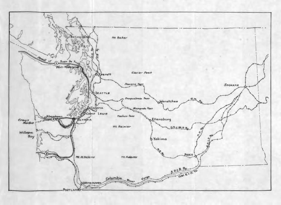
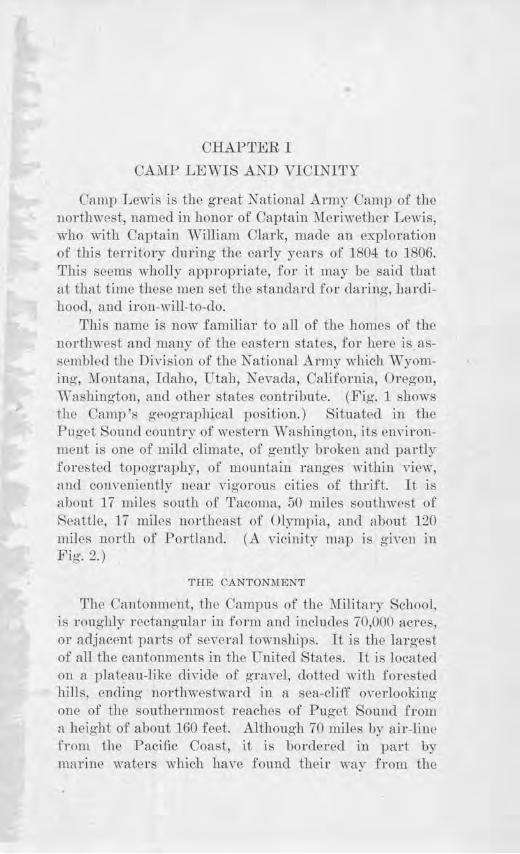
This name is now familiar to all of the homes of the 110rthwest aud many of the eastern states, for here is assembled tho DiYision of the National Army \Yhich Wyoming, ::\Iontana, Idaho, Utah, Nevada, California, Oregon, '\Yashington, and other states contribute. (Fig. 1 shows the Camp's geographical position.) Situated in the Pug-et Sound country of western Washington, its en"ironment is one of mild climate, of gently broken and partly forested topography, of mountain ranges within Yiew, and conveniently near vigorous cities of thrift. It is c:1bout 17 miles south of Tacoma, 50 miles southwest of Seattle, 17 miles northeast of Olympia, and about 120 miles north of Portland. {A \'Lcinity map is giYe11 in Fig. 2.)
THE CANTONMENT
The Cantonment, the Campus of the "Military School, is rou~hly rectang;nlar in form and includes 70,000 acres, or adjacent varts of several townships. It js the lar gest of all the cantonments in the United States. 1t is located on a plateau-like uiYic.le of gra,·el, clotted with forested hills, ending uorthwest\\~m·d in a sea-cliff overlooking one of the southernmost reaches of Puget Souucl from a hoig·ht of about 160 feet. Although 70 miles by air-line from the Pacific Coast, it is bordered in part by marine waters ,,~hich haYo folrnd their way from the
10 B'lllletin No. 18, Washing ton Geological Survey
great ocean around the Olympics through the straits and passages of the Puget Sound.
THID CAMP
The little city of barracks is located in the western part of the Cantonment. They are arranged in orderly fashion in two great curving arcs which face each other convexly. Avenues, named after the states, run longi-
Fto. 1. Map showing the geographical posi tion of Camp Lewis.
tudinally through the two long curves of barracks, while intersecting streets divide the sections into blocks. Two main drives lead into Camp, converging from two entrances, the Lewis Drive and the Clark Road. (The general plan is shown in Plate I. ) The ·wide vista between the two curving arcs of barracks open southeastward
The Country abmtt Camp Lewis 11
toward Mt. Rainier. Here in view of this great sentinel the activities of the Camp take place.
TRANSPORTATION FACILITIES
Railroad transportation is afforded by the Northern Pacific Railway and the Chicago, Milwaukee & St. Paul Railway, which make direct connections with their o,vn and other transcontinental lines. The paved Pacific Highway passes by the Camp and serves as an excellent automobile thoroughfare to Tacoma and Seattle on the north, Olympia and Grays Harbor points on the west, and Portland on the son.th. Licensed auto stages and the street car to Murray, supplemented by jitneys the r emainder of the distance, afford convenient facilities for getting back and forth between Tacoma and Camp. Frequent train service on various lines, electric interurbans, and several steamships offer a choice of travel £°or Vi'eekend trips to Seattle.
CITIES NEAR THE CANTONMENT
TACOMA
Tacoma, the nearest city to Camp Lewis, is the county seat of Pierce County, and is located on a peninsula between Commencement Bay and the Narrows of Puget Sound. It has an area of about 40 square miles. The city has bcautifo 1 residential districts and parks, progressive churches and schools, and extensi,~e interests in lumbering, ship-building-, flour-milling, and meat-packing. The present harbor has 1-! miles of water front. In ] 910 Tacoma had a population of 83,743, which increased to 108,09-:1: in J 915, and ll 2,770 in J 916.
SJ.:ATTLE
Seattle is the largest city of the Northwest, lying on a harbor probably unsurpassed by any in fue world. It is situated on a group of hills which rise from sea-level to 500 feet in altitude and cover 58% square miles. Here
12 Bulletin No. 18, Washing ton Geological Survey
several trunk raill'Oads meet the deep sea navigation of various steamship lines that ply between Seattle and China, Japan, Alaska, Hawaii, the Philippines, Australia, and other foreign countrjes. Seattle possesses several large ship-building plants and nearly all phases of manufacturing, mining, fishing, and agriculture occupy the tributary region. The high hills are fine residential sites. The State University is located in the northern section of the city overlooking Lake Washington and Lake Union. Since 1880, Seattle has grown from a village of 3,000 to a city of 348,639 in 1916.
OLYMPIA
Olympia is the State Capital and a city of about 7,000 inhabitants. It is located at the southernmost reach of Puget Sound, on the lines of the N orthcrn Pacific Railway and Oregon-Washing-ton Railroad & Navigation Co. It has a good harbor, but is rather remote from the main steamship lines to the Sound. On the tidal flats , lEtrge areas are devoted to oyster beds, and the bordering territory is important agriculturally.
F10. 2. Vicinity map showing the relation of Camp Lewis to the nearby cities
CHAPTER II
THE SURF ACE FEATURES OF WESTERN WASIDNGTON AND 0]"' THE CA1\1P
LEWIS CANTONMENT
Nature has endowed western Washington with special featm·es. She has given it a position adjacent to the greatest ocean of the globe, an inland harbor system of superior character, and a most diverse landscape. F rom the P acific Ocean on the west to a north-south line running through the middle of the state, there are two mountain ranges separated by a broad trough-lilrn dcµression known as the Puget Sound Basin.
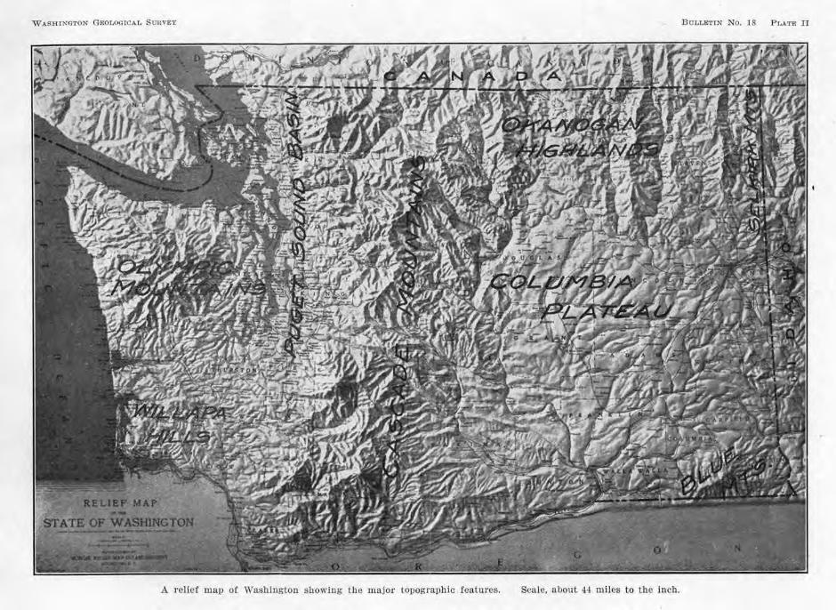
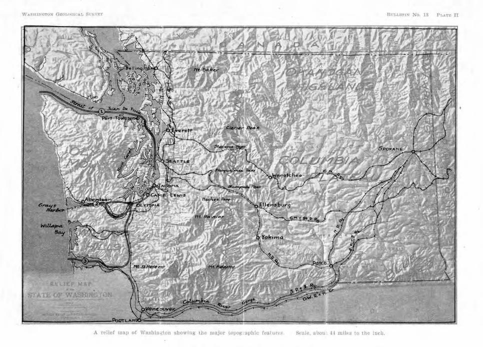
The western range, which lies along the coast, is sometimes called the Coastal Rano·e. It includes the Olympic Mountains in the northwest anc1 the ·wmapa Hills in the southwest. The mountain range to the east is the Cascade Range. (Plate II shows the position of these features and the location of Camp Le'1171S with reference to them.)
On clear days and from many points of vantage, both the 01ympics and the Cascades may be seen from Camp, in practically their whole relief.
THE OLYMPIC .MOUNTAINS
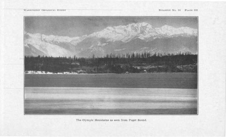
The Olympic Mountains constitute nearly the whole of the Olympic P eninsula, north of the Chehalis River Valley and west of the Pu&et Sound BasiJ1. In either direction their dimensions are about 50 miles. F rom the vicinity of Camp, they are seen to the northwest.
They are a group of peaks, ridges, and passes with canyon-like ,alleys cutting their slopes. On the east they rise abruptly from Hood's Canal (Plate III), the weste1·nmost inJet of Puget Sound1 but on the 11ortl1, west, and south they a1·e bordered by a relatively narrow imcl more or less broken plateau of approximately 500 feet elevation. Although not so extensive as the Cascade Range.
The Country aboiit Camp LPwis 15
they excel in rnggerlness. :Many sharp ridges rise to approximately 4,000 feet in hejght, with some higher })Cal<s exceeding 8,000 feet. :Mt. Olympus is 8,150 feet high. As seen from a distance the jaggedJ1ess of the crest line has sometimes gi,·en it the name of" Sawtooth Range." With their perpetual .fields or snow, tbC'y present a Yiew of impressive grandeur.
THE WILLAPA HILLS
The Willapa Hills are high hills or lo,y mountains which border the Pacific Coast from the Ohehalii:i River Valley on the no1-th to the Columbia River ·vallcr on the south. Their ma,'-i.wuru elevation is much lower tlum the Ol~'UllJics, being about 3,000 feet, and lower than the Coastal Range of Oregon which has a similar position along tho coast, south of the Columbia River. Nowhere do they rise above the tree-line.
These bills arc too low to be seen from Cmnp, hut soldiers from that part of the state are well aware of the immense quantities of lumber which their forests yield. On the west side especially, the forests are almost impenetrable.
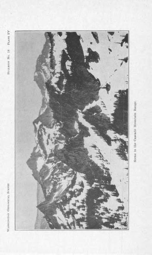
THEJ CASCADE MOUNTAIN RANGE
To the cast from Camp, the most extensive surface of major prominence in the state of Washington can be seen-the Cascade Mountain Range (Plate IV). Keeping an average summit altitude of 5,000 to 6,000 feet above sea, with some points much higher and some passes lower, the Cascades stretch from north to south and extend beyond one's nsion and the boundaries of the state. Indeed, they are a part of a great mountain chain which exte11Cls most of the distance from sontlie1·n California to AJaska.
Snow fields linger on the hlghcr peaks during the summer and in winler their mantle of white :is extended
16 Bulle! i11 1Y o. 18, Tra. liin.(Jfon G,,ological S nrvey
o,·cr much of the rnnge. At its base lie the fooU1il1 , coYered by luxuriant forests of tropical density.
Aero. s the mountain range the Columbia Ri,cr Jias cut a deep gorge, which is r eg-m·ded as the na tural bounchny between Washington and Oregon. This pass has been cut nearly to sea-le\7el and through i.t the explorer , Lewis and Clark, ga ined r eady access to western Washington. The other passes of the Cascades haYe been formed wher e the h eads of dra iuage lines on either side meet. Of these the 1owe ·t and most cons1Jicuous i , noquahnic Pass, which has an e1e,7 atio11 of 3,010 feet ~ncl ,dlich i u eel hy the Sunset Highway and tbc Chicago, Milwaukee & St. Paul Railway.
everal p eaks of di,·cr se origin rise above the gcncr,:ll summit level of the Cascades. There arc p eaks of granite, Sll Ch as M t. Stua r t, which reaches an altitude of 9:+70 feet abo,·e ·ea-Je,1cl, and extinct volcanoes which smmount the Casc,1de, irnd tower s till hi.ghcr than l\rt. Stuart. The ·c nr<' :Mt. Rainier, J4,408 feet; Mt. Adam·, 12,807 foci; :ML Baker, 10,750 feet; Glacier P eak, JO,.t36 feet, and Mt. St. H elens, 9,671 feet. Their positions i11 the range nre shown. in Plate IL Mt. A(fo.ms and Glacier Peak occuT near the . ummit line of the Cascades, while' :Mt. Rainier, :Mt. Balcer, and J\lt. St. HelC'ns are situated on the flanks.
MT. R.\1N1E}R
By Yirtue of itR position and comr,ara t iYe near ness, hft. R.c1in icr is the Great Sentinel of the C,nnp. Looking slightly south of cast, the soldier at Camp Lewis may view its towering . l0pes and r ounded . ummi t, almost lJidden hy snow-fields and glaciers, with only her e and there the dark li11 e of r ock appearing. AboYe where b e . ta11ds the mountain ri ses more than 14,000 feet, or OYC L' 2y~ miles. This accounts for its seeming· ncm·nc s, eveu though it is 35 miles away. It is the bulwark of the line ; compm·ed with the Ca Mdes it stand. 211:., time
The Country about Ca111p Lezci:s 17
their average height. To the lndians or early days thi · was the ")fountain that was Goel"
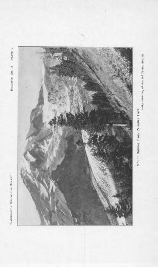
The rN1lru into which it Teaches is quite different from fhe ordinary cot1ditions nt tile sm·foce of the earth. From its base, its slopes gTadually asccn<l tmtil iliey pcnetn1f e the higher rnrificd and frigi<l atmosphere where 11cither plm1ts nor c111imals cm1 exist. It is C's! imatell that the cltmosphcrc around ils summit on a q11ict <la~· cm1tains ahout +O p0r cm,t less oxrg-en ancl otlwr gases, by weight, tlrnn the atmosphei-e ::d Carup. Hs tcmpcrnturc is also colclrr l)y -1 dcp;rees, if one reckons the usual 011e dc!..?,'rce c.1ccrense in iempera1.ure "i tll cYcry :-300-foo( rise. "\Yilh such a temperature the moisture in the c1tmospl1cre above a certain lc,Tcl is condensed ai:; snow instead of rain ancl in consequence eternal suow caps its sunuuit and mantfos its s lo):ws, accumulnti11g to such great thicknesses 1.hat it is tnrnsformcd -into glacial ice. These ;rlaciers, which uow 1mrnbcr at least :26, nrc gouging· and furrowing its slopes m1cl havC' hccn tor ages, c.-11Ti11g nu111~· rnmpnrts, cliffs, aucl canyons. (Plate V.)
The appcnnrncc of Mt. Hai11ic1· srems lH'V<' r to he <]uite the same. From hour to hour the sun's rays shine> on ii from di ffe1·e11t ang-les nn<l with chnnging intcnsii.y, from the glow of daw,1 to the brightness of mid-clay and the purple of sunset. At times lb<' mountain stanc.ls out bold and elem·, ~rnd then again clouds form about its summit, or b iclc its has<.:>, or toll 1 ike thu11<lcr clouds up its slo11c>s. Thc>sc> and other touches of Natm·e, togcUH'r with th<' changing position and niood of i.hc ohserv<'r, gi,·c the Great S('I1fo1cl DC'-'' aspects from tin1c to time.
THE ru:ROUHCES UP 'l'IIN CASCADJ,;R
The resources which the Cascades hold for man's economic lle,clo1m1c11t are import,mt. The rnin<.•ral lleposits comprise coal, gold, silver, copper, k-ad, zinc. tungsten, molybdenum, arsenic, nntimo11y, mercury .-md
18 Bitlletin No. 18, 1Yashington Geological Sit.rvey
other minerals. The fores ts which clothe the western slopes contain millions of feet of lumber, and the waterpower resources are greater t111-111 in ar1y other state in the Union. Although many projects have been installed, there rcmaiJJS much to be developed. Duru1g the present coal crisis, when coal had to be conserved for the use of war industries, the value of Washington's water powers was emphasized.
THE PUGET SOUND BASIN
Between the Olympics on the west and the Cascades on the cast lies the broad Puget Sound Basin. Plate II shows this depression, beginning north of the Canadian bom1dary and extending southward between the Olympics and the Cascades to and beyond the Columbia River. Its northern part is extensively developed, having a width between the Olympics and the CHscades of about 50 miles.
GENlilRAL CHARACTER
The Puget Sound Basin is a plain country averaging 400 to 500 feet above sea, incised by ramifying troughs averaging one to four miles in width. A pa-rt of these troughs or i.nlets is occupied by marine waters and connected with the ocean by the Strait of Juan de Fuca, which lies to the north of the Olympics. In Plate VI is sho,vn a view across one of the troughs at sunset. Interspersed with the var ious inlets, passages, and bays, are flat-topped islands, peninsulas, and borde1· land, most of which rise in sea cliffs from the water's edge, 100 to 250 feet high. As seen on the fancy tissue of Plate II, there are two major inlets extending south from the Sti-ait of Juan cle Fuca. The one to the west at the foot of the Olympic Mountains is Hood's Canal, the one to the east j s Admiralty Inlet. The latter carries practically all of the Commerce of Puget Sound. The northern part of the Basm is mostly submerged, with many rock-islands
\VAi:H.lfNOTON O.t::OL.OGICA J. StlH\."E\" BUL), l:."'l'lN No. 1 8 PLATE n:r
The Olympic Mountains as seen from Puget Sound.
20 Bulletin No. 18, Washingtou Geological Survey
rising above the water-level and comprising a group, known as the San Juan I slands.
Al's OLO DRAINAGE SYSTEM
The troughs of Puget Sound and the Strait of Juan de Fuca are, for the most part, former river valleys which have been partly submerged by a general depression of the land area, permitting the sea-water to come jn eastward for 100 miles, southward for 5 miles, and northward for a sti11 greater distance. During the Glacial P eriod, the inlets were gouged sti11 deeper by the great glacier. These events have given rise to one of the best and la rgest ha1·bor s in the ·world. For a proper appreciation of the s ize of th.is inland body of water in Washington it should be stated that the distance from the northern boundary to the southern limit is about 150 miles, or greater than tho rn,erage length of the state of Massachusetts. The waters arc surprisuJgly clcep1
averaging from 300 to 1000 feet, and ships of any tonuage can reach the ports of Seattle a11d Tacoma at lowest tide. Another Hdvantage jg protection from storms. The inlets are sufficiently narrow that the small expanse of water docs not permit large waves to he generated by the winds. Dmfog 1917, over four hundred ancl eighty-fi~e million dollars' worth of impo1·ts and cx-p<>rts were handled on P uget Sound.
TOPOGRAPHY OF THE CAMP LEW IS CANTONMENT
The Cantonment is located on an upland ·which borders the Ni.squally River on the southwest, the P uget Sound on the west ancl northwest, and the Puyallup River on the north and east. South of Camp the surface is quite rolling and heavily timbered, but to the nor theast lies a le-.;-el stretch with only a few sea ttercd bills rising above the general level . (Plate 'VII.)
Approaching Camp along the P aci:fic Highway, from the nor theast, these hills, with theiT covcri.ng of timber,
The Cmmtry about Camp Lewis
break the sky-line and give relief to the otherwise level landscape. North and west from Camp ihe flat country is wooded with a forest that has partly sprung up since the early settlement of the region.
The grounds near the Northern Pacific depot arc about 250 feet above ilie Sound. From here east there is an imperceptible rise of about. 40 feet to the east end of the Camp and westward a gentle decline of about 70 feet for two miles or more to the brink of a 180-foot cliff, at the foot of which lies Puget Sound. T\vcnty mil~s north and slightly east the upland tm·minatcs in Pt. Defiance.
DRAINAGE
Surface streams are few, owing to the flatness of the upland and the favorable underground drainage. They consist entirely of little brooks flowing quietly in shallow trenches of more 01· less ·winding nahU'e. The first stream north of Camp is :Munay Creek, which empties into American Lake, and the second nnd larger is Clo,7er Creek, which flows into Steilacoom Lake and thence into tbc Sound by way of Chambers Greek.
Northeast of Camp, four lakes occur in a series, curving from north to southwest and west-Steilacoom Lake, Gra,~elly Lake, American Lake, and Lake Sequalitchew. l\Iore beautiful bodies of water are rarely found. The water is clear and of moderate depth, the shores arc of gravel and rise about 25 feet above the lake-levels, and the bordering groves of txees and the distant mountain give a wonderful setting. Lake Sequalitchew is the only one which occurs within the confines of the Cantonment, but the southern shores of American Lake lie along the boundary. The latter lake is nearly four miles long and about one mile wide in its widest portion, \vitb se,-.eraJ small islands and inlets and bays to tldd to its charm. (Plate V1II. ) As a bathing resort dul'ing the summer it is the Camp's chief attraction.
22 B·ulletin No. 18, TV ashingto:n Geological Sitrvey
American Lake has an elevation of 238 feet above sealevel, and Sequalitchew Lake is 215 feet; the two are separated by a gravel barrier about 300 yards ,vide. This discrepancy in level ,vith only a gravel dam between is to be accounted for. It is believed that the pores in the bed of American Lake, in at least that portion near Sequalitchew Lake, have been so thoroughly filled with silt that there is no underground connection with Sequalitchew Lake.
Another beautiful little lake, Lake Spana,vay, occurs near the east end of the Cantonmeut.
Due to the extensive gravel formation and the uniformly level topography of the upland, much of the rain which falls seeps into the ground and disappears by undergrotmd drainage. Some of the ground-water of the Cantonment seeps into the lakes and some of it feeds the springs along the cliff that borders the Sound and along the side slope of Nisq_ually River Valley.
The ground-water level is· usually at varying depths beneath the land surface, but in the case of permanent lakes or swamps, it is at the surface. Where it is beneath the land, seasonal differences in rainfall will cause a variation in the height to which it rises. Since most of the rain at Camp Lewis occurs in the winler, the ground-water surface is hig·hest at that time. vV"i1.cm the rains cease, the gravels drain the water away so promptly that duriug the dry season the ground-water level is much lower.
The factor of ground-water must bo reckoned with time and again in the many-sided activities of military life. Besides being useful as the common source of water-supplies, it may be a constant menace to camp drajnage and sanitation, to trench warfare, to the crossing of bogs and swamps, to the maintenance of roads and railroads, to the transportation of heavy artillery, to the use of tunnels and caverns, and other militarJ'
The Country about Camp Lewis 23
projects. At Camp Lewis, mru1y of these difficulties are not confronted in their most serious phases, due to the excellent site of the Camp, but the dif6culties of t r ench drainage are well illustrated in the practice henches on the hillcrcst sout.h of ibc Camp.
This hill has a loose, stony soil m1d suh-soil of three or four feet in depth, but below this the rnnterial is hard 1:md compact a11d quite impervious to water. In conseque11ce the water which seeps in at the surface penetrates but a few feet an<l then moves latcrc-1lly according to ilic slope of tbe contact of the soft and hard matel'ial. This, in addition to the water which runs in from the surface in wet weather, keeps the trenches wet and necessitates oth<'r measures to make them of any use. If the loose material extended deeper so that the contact with the impe1Tious formation were well below the bottom of the trench, or jf the trenches were in a sandy soil, the drainage would be n:rnch more satisfactory. In a permanent line of defense such factors must necessarily be co11sidered.
WA TE:R -S1TPPL TES
The water-supplies of the Camp are obtained from springs. In consideration of their importance the location is not here g-iYen. Examination was carefully made to determine whether their source is local or not. The wat.ers are entirely free from bacteria, which shows that they cannot have any near surface connection. Their source must be a sufficient distance away from any possible contamination so that the bacteria arc destroyed by long u11der-g1·ound filtering and non-e~--posure to substances upon which bacteria can live.
The volume of the spr'ings thns far seems adequate, there being but little fluctuation in the flow in wet and dl'y seasons. Dt11·ing Februa1·y, 1918, the 63 gallons of water r equired per man for the 31,000 men at the Camp were amply supplied by the springs.
2+ Bulfpf'il, Xo. 1 , ll'ashiu.qton Geolo,qical Su rvey
Three. torage tanks have been erected on a hill within the Cantonment, 100 to 150 feet above Camp. Each 1m. a capacity of 200,000 g·allons. In 1faTch, J918, seven mouth after ilieir initial use, there ·was occasion to expose tlle bottom of one of these and no ilt accumulation was found. Th is and the analyses for bacterial content i11clicatc that the water i. of .fir t quality.
SANlTA'l'lO.~
~rhc excellent drainage afforded by the gravel formation 011 which the Camp i located has already been noted. There are but fow pools of standing water clo. e to Camp which may be infested with mosquito('. and othcl' germ canier s, and they can easily be brought under : ani tar.v control. Ex.ten ive mar ·bes arc far di tant.
Di posal of the . ewage is made in Puget Sound, three mifo to ihc w·cst. ln excavating for the sewage line, gn1Ycls and snnds were foun<l tlD:oughoat the whole di stance. The gc11eral wcsbnn·d slope of the fo rmation made cxcessi,e digging unnecessary to giYc the proper gn1dic11t for the . cwage l ine.
ROA:0 CONDl'J'IOKS
'11hc g raYel plain furnishes all of the r equi site condi t ions for good road-building. The topography i . essentially l evel, the gravel afford an ideal foundation and proper drainage, and abundant materia l is aYaila blc1
either for ordinary urfacmg- or auy firt-clas type of paYern<.'n t.
The Pacific Highway i pav<'d the whole d istance from Tacoma to the NisquaUy Hi,-er , with a minimum width of h feet. Plans are no,v under way to widen t]1is to meet the ,neatly increased traffic which t1JC ex istence of Camp Le,Yis has brought about. The only grnde of con:equence is at Ta.coma where the ascent i s rnncle from near sea-level to the low pass in the southwest part of the city1 ha,--i.ng an elevation of 230 f eet. F r om here to
The Country about Camp Lewis 25
Camp the grade is nearly level. In approaching Camp from the direction of Olympia there is a grade at Ni. -qually River, but this is also moderate.
·when the Camp was first h1stituted it was predicted that since the Pacific Hig-hwar was not paved for such heaYy haffic as is now brought to bear on it, the life of the pavement would 1,e of only a few months' duration. ·with the exception of a few instances the pavement was in good con<lition in -:\[ay, 1918. Its success in surpassing: t.he predictions is probably due in part to the superior foundation which the gntYel formation affords.
Quarries of solid rock arc nowhere to be found in this ,ricinity, but their absence is of no consequence in Yi<'w of the abunchrnce of gravels.
:'IL!l~ITARY l1SES
.Artillery positions require a foundation which i!-3 firm and elastic, and, for practice work, hills which will minimize the dangers to the territory beyond. The situation at Camp Lewis meets these conclitio11s a~lmirably. After the removal of the surface soil and the proper placement of the heavy guns, the gravel formation yields but slightly to vibration effects and its return to the former condition is instantaneous and quite perfect.
The broad expanse of the Cantonment, the association of hills with the prairie, and the forest co,,cring of the bills and of the area west of Camp make possible almost any type or army maneuYer 011 a large scale. These ma]l(.'UYers may be extended to mountain topography, 35 miles away.
CHAPTER III
THE ORIGIN OF THE MOUNTAIN RANGES AND OF THE P GET SOU:NTI BASIN
There is no doubt in the minds of those who haYe made a careful study of the earth that inunense lapses of ti.me have transpired since it wa formed. A knowledge of how rocks are made, of the great thiclmess to which they have accumulatc•d, of the profound change· which they haYe undergone, of the widespread and repeated shifting of the shore-lines, of the r evolutionary changes in bills, valleys, and plains, and of the imperceptible rate at which these changes take place-a knowledge of these things con,•inces the iiwestigator that the earth is extremely old, that if the time since its early stages could be e:i..'Pressed in year I the fio·ures would be beyond all comprehension. The leno-th of a thousand yca1·s is difficult for the human mi.nd to grasp, and a hundred thousand years impossible. Yet by adding one's conception of the length of a cer tain epoch to that of another, and then to that of another , until all of Urn known epochs of the em·tlt 's history have been con i<lerecl, the summation mounts into millions of years.
THE CASCADE RANGE
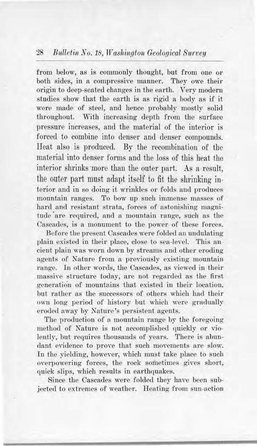
Dul'i-ng this prodi0 ·iously long- history, mountain ranges have come and gone. In the ancient past, the1·e were mountains in existence in some parts of the continents where now the land surface is a plain. This is true, for example of southern Canada. On the other hand, certain regions which were once pla i.ns are now folded into mountain chains. Such bas been the history of the Cascade Mountains.
The Cascade :Mountains came into existence through the action of great earth forces bowing up immense thicknesses of rock. These forces were applied not so nrncb
j j
·. 1-,f I
.....
28 Bulletin No. 18, W a:shvngton Geological Survey
from below, as is commonly thought, but from one 0 1·
both sides, in a compressive maruler. They owe their origin to deep-seated changes in the earth. Very modern studies show that the earth is as rigid a body as if it were made of steel, and hence probably mostly solid throughout. With increasing depth from the surface pressure increases, and the material of tho interior is foTcccl to combine into denser and den er compounds. Heat also is produced. By the recombination of the material into denser forms and the loss of this heat the interior shrinks ·more than the outer part. As a result, the outer part must adapt itself to fit the shrinking 111-terior and in so doing it wrinkles or folds and produces mo11nta in 1·ang-es. To bow up such immense masses of hard and resi tant strata, forces of a tonishing magnitude· are required, and a mountain range, such as the Cascades, is a monument to the power of these forces.
B efore the present CAscades were folded an undulating plain existed in their place, close to sea-level. This ancient plain was worn down by streams and other eroding agents of Nature from a l)reviously existing mountain range. I n other words, tl1e Cascades, as viewed in their massiYe structure today, are not regarded as the :fir t o-enel'ation of mountains that existed in their location, but rather as the successors of others which had their own long period of history but which wer<' gradually eroded away by Nature's persistent agents.
The production of a mountain range by the foregoing method of Nature is not accomplished quickly or violently, but requires thousands of years. There is abundant CY idencc to pro\·e that such movements are slow. In tlw yielding, however, which must take place to such OYerpowcring forces, the rock so1i1ctimes 0 ·h-cs short, guick slips, which r esults in eaTthquakes.
Since the Cascades were folded they haTe been subjected to extremes of weather. Heating from sun-action
The Oouulry about Camp Lewis 29
and cooling at night, rnin-wash, stream erosion, frostaction, and glaciers-all h,n-e accompanied and ai.do<l each other in weathering the rocks, etching a rugged crest-line and canTing- canyons and valleys clown their Cianks, threatening the mountains with the same destiny as that of their predecessors. But with all of this, they 8till stand as a mountain range of the first importance in vV ashing-ton.
J\f'r . .RAl~JElR A:S:D O'l'Hl'.:R SIMILAR PE:AKS
In 11t. Rainier an<l its related peaks, Mt. Adams, Mt. Baker, Glacier Peak, and )iit. St. Helens, we hcwc an example of another type of mountain-buil<ling-. After the birth of the Cascade 1\Iounfaius, or possibly duriug their formation, these peaks came into existence in an altogether different way than by folding. At the points where t1lese peaks are no,Y located, molten rock from the interior of the earth broke through :mcl formed volcanic craters, and as laYR poured forth and volcanie ash and cinders were ihrowi1 out, lofty cones w@ro built 011
lhe flanks and summit of the Ca. cades themselves, until they reflchecl altitudes thousands of feet aboYe the range. ·with their sulllJ)ljts in the high atmospheric zone of snow and ice, glaciers formed and these ageuts of clestruction are now slowly but constantly ·wearing and grinding· away- the xock substance of which the peaks a1:e made.
Whether l\It. Rainier and the oULer extiuct Yolcanoe~ wil1 ever l)ccome active again cannot he c.leterminocl or sa.fely predicted. During tho period of eruption, the ]aYas had their source probably in local resenoirs deep beneath the earth's surface. A renewal of their actfrit? r1opcnds partly upon whet.her these reservoirs were exhausted or whether more lani has been or will he produced by the heat of compress ion and other sources, and
• whether the forces necessary 1-o bring· tlte molten material lo the surface wm be generated ap;ain.
30 Bulletvn ti o. 18, TV ash'imgton Geologiical Surivey
THE OLYMPIC MOUNTAINS
The Olympics were made in much the same way as the Cascades, and were not constructed by volcanic action. None of the higher peaks of these mountains are of volcanic origin, but they owe their prominence to uplift and to the superior hardness of the rocks which compose them as compared to the rocks around them. Thi is au
example of the difference which results from the prolonged action of rain, frost, and glaciers on a mountain group made up of rocks of unequal hardness. All of the
present summit levels are probably considerably below what they once were when the Olympics were fu·st uplifted and before Nature's erosional agencies hacl had time to accomplish much.
The Willapa Hills are due to folding and ,varping, but they probably were never so high as either the Cascades or the Olympics, and their r eduction since thejr l)irth has probably been more rapid, due to the soft character of much of the 1·ock.
THE PUGET SOUND BASIN
A study of the condit ions of origin of this remarkable basin between the two mouutaiu ra11gcs, with its J900 miles of shore line and superb harbor, has resulted in the discovery of some very interesting natural history for westem "'Washington and the vicinit)r of Camp L ewi.s.
,Jnst as the history of the ranges was not one of sudden v iolence but a gradual progression of events, so has boon the history of Puget Sound itself. Its record of known events seems to begin ·with the period of mountaipbuilding and to have included still more r ecent history.
Whe11 the Cascade :Mountains were folded, a general cleprc. sion took place along thefr west base, beginning in Canacla and continuing southward 11ea1-ly the whole extent of the rnnge. This ,vas the first step, .it seems, in the history of this great trough. Then depo. its of clay, ' and alld gnwel accumulated ,,~thin the trough, brought
The Country about Camp Lewis 31
b? streams from a tlistai1t glacier ill British Columbia. So thick did these new sediments become and so widesprea<l, that the old ,·alleys were completely filled, most of the former hills buried, and a new plain constructed, 1:1 boYe the old topograpb~·. The rna tcrial which was laid down at this time is now CX})osccl in the high bluffs at the Tacoma docks aud Pt. Defiance.
Following this depositi011, the lowlaml was slow'ly uplifted, as ihe i-esult of internal changes in the earth, until it reached an elevation of 11carl~ 1,500 feet aboYe sea. At this height, the sb·cams of the area hegan to cut rleep c1unrncls and in the course of time they were c.lccpenecl to canron p1·opo-rtions. The whole region was so dl'eplr dissected that it became exceedingly rough. The Strait of J ua11 de Fuca hecarnc a great valle?, having as tributaries Admiralty Iulet mid oth~1- trougl1s. The amount ot time consumed hy Kature in cli.augiug llie original flat surface to tb is col1C1ition must have been thousands upon thousands of years, for streams are uot capable of making· mnch change in the general land Stu
face dming the life-time of an indh·idual. St1ch ,vas tbe character of the Puget Sound country
until a lowering of some 1,000 feet of the whole region penniUC'd the ocean waters to enter the lower portions of these valleys, drowi1ing them and converting them into inlets and bays. At about this tjme tho climate became gh1cial rmd a great ice-sheet, the character of which "riJl be described hereafter, overrode the basin, modified the surfc'tce, gouged out the troughs to greater depth, and left a mantle of glacial debris scattered unequall>· O\'e1· the area. But with all of this, it i'ailetl to tlestroy the major houghs which furnish the important clue to the former historr of Puget S0m1d. Thus the old drainage system became a most excellent harbor srstem.
At the same time that the sinking of the Puget , 'ouncl Basin took place, the same thing- happened to the western
3:l B11lleti11 iro . 1 , 1rashiil1,11to11 GPolo_qiical Survey
coast, p1·oclucing the bay of Gray's Harbor at the moutli of the Chehali Valley, "\\7illapa Bay at the mouth of "\-Villapa Valle~·, an<l a bay in the lower portio11 of the Columbia River. Tl1is is characteristic of all the world's bestharhoTs. London, Jew York, Boston, San Francisco and other ports arc all on coa. t-lines which have unk during the latter part of the earth's history, and they owe theu· importance to this eYent.
"The bills are shadows, and they flow From fo rm to form and nothing stands; Tbey melt like mists, the solid lands,
Like clouds they shape themselves and go:·
-Tennyson.
CHAPTER IV
THE CLIM.ATE O.B"' C~IP LKWIS
'TEMPERATURE
H the climate of Camp Lewis were <leforrnj11e<l b~· latitude alone it would be the coldest camp in the United Sh1tcs. The forty-se,enth parallel of latitude lies along the south boun<lary of the Cantonment. Tracing this across the map of the United States, it is found to pass north of Duluth, Minn., and through the very 110rihern part of ~Iaine. The fact, then, that Camp Lewis lies so far 11orlh in the United States and yet has a mild cLimate demands fill explanation.
The secret for this lies in two factors: First, the 0xistcnce of the Pacific Ocean with the .Japan current off the western shores of \Vasb ing'ton, and second, the prcYail i11g winds from the west. Such a lnrge bod)- of water as the Pacific Ocean is not respousivo to dail.v or seasonal changes of healing- .. mu cool ing, a11<l, ther efOTe, duringboth summer and wi11ler, ii nmmlains a remarkable uni formity of temperature. ln this laiitrnle the ocean's warmth is increased b>· the .Japan current which drifts from the equatorial belt south of the islands of .Japan. With tlte winds blowLng from ihe west these conditions of uniform m ildness a.re transl'crrcd to we tern ·washington tlu-oughout the year.
Taking mto consideration the prcs('nL climatic co11-dition.s of the earth, this combination of wester!)~ winds and oceanic influences are more efficient than any otbC'r combination tlrnt -Xaiure m ight make in this latitu<le. If an arctic currc11t were to r eplace tl1e .Japan current, the climate would become very raw and unpleasm1t. On the other hand, if tlto winds were to blow from the east insleacl of from the west, en•11 ,Yith the warm .J apau current washing the western const, the "-i11ters would he YCr>' cold.
-2
34 Bulletin Nu .18, lTashingto11 Geological Survey
TEMPERATURla RECORDS AT TACOMA
During 17 years of weather record ing at Tacoma, which may be taken to apply to Camp Lewis1 the lowest and highest temperatures ha--rn been read for each day in the y·ear. These records . how some inter estin<>' facts. During the summer the arnrage temperature of the day has been 71 degree ; of night, 52 degrees. This shows that the clays are comfortably warm and the nights refreshingly cool. During the ·winter, the temperature has had an average cfaily rano-e from 45 degrees above zero during the day to 35 degrees aboTe zero at night. Frequentlr there is only five degrees cliffercnce between da)-r and night. This low range is due pa.rtly to the groat ocean, partly to the southerly ·winds in willter, and pal'tly to clouds whicli pr eYcmt excessive heating \n the day and cxcessi ve cooling at night. Toward the la ttcr part of the willter, the winds temporarily shift to tho northeast nud blow from east or the Cascades, or descend from the high cold rogious or the atmosphere, producing sharp, frost~· . polls of short duration. nch days are always bright ai1d clear.
CO:;\fP,\ R1S0N 0 1'' TEM.f'F:RATUHE CONDITTONS AT THE: DJFl"ERENT CANTON~fENTS
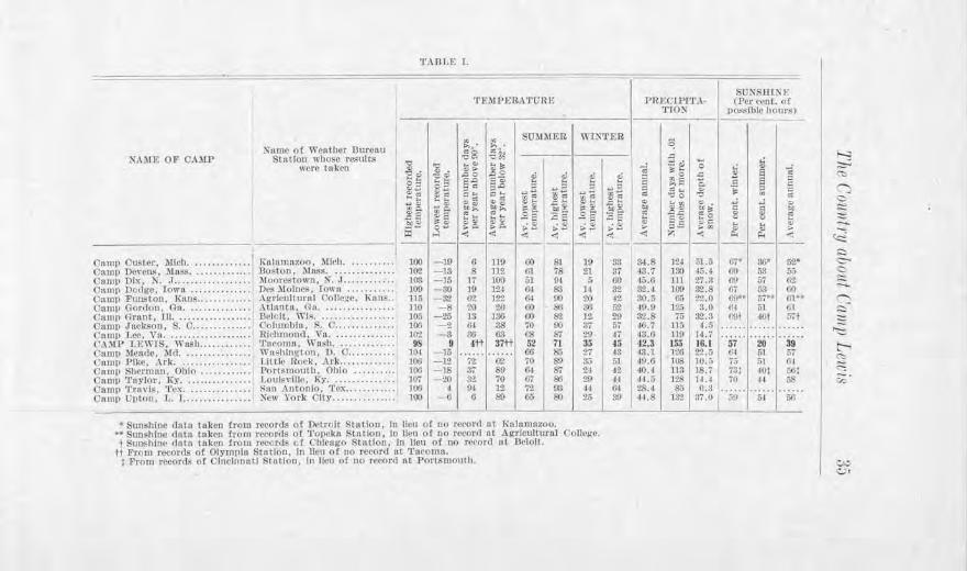
A comparison of tho temperature conditions at the different cantonments is of generaJ and officinl inte1·est. It is of general interest to know the conditi on. under wbich the soldi er s at the different cm1 tomncnts 1i\·e, and of officinl in t0rest in the issui11g of food, clothing and equipment, and in formulating plm1s for training. The followi11g data have been compiled from the r ecords of the United States W cathel' Bureau aud tabulated on the following page. Si11cc in most cases tbe cantonments are not located in cities wher e tliere arc \\'eathcr Bureau . tations1 the r ecords of the nearest official stations bavc been taken, proYicled the stt1tion is in the vicinity of the cm1to11 me1Jt. 8
• The names of the stations which furnish the daln for each camp :, re g lven in t he lab l e.
'l'.\BL!s I.
-- -~ I 'l'FMt>J,R.NrURV. PRl~Cli>l'l'.\
'J'TO:S-
UJ ., SOMMER -wr.~·rE.a ~
NAME OP CAl\LP
<'am1• Custer , 'Mich ............ ··l <: am1• Dovcn.i..,, . .\I u.s.4; • ••••.••••.••• Camp Dix, X. J ................. . ('11m1> no,ht~. !own ............. . Cnmr> l'tuJSton, Knn~ .... .. .......
1 Cnm11 Con:ton, Gn .............. . C'am11 Grrrnl, lU ................. . Cnmp Jnckson, S. c ............. . C'nmr, tee. Yn ................... . CAMP l,EWlS, " 'nRh ........... . C11m1> l.lNt<le, Md ••.••.•.••.•.••• Comp Pike, .\rk ................ . Oamll Sh~rmnn, Ohio ........... . <'nn111 ~PnyJot J Ky . .............. . OnmP 'J"ntvL..:, 'rex . ....... . ..... . Onm11 Upton. L. ! ............... .
urenu nits
Numo ol Weather 1' Stu lion whose res'
were taken 'g ,:, .
I ~ ~ '-';; :!:!d .u t '/'I/ C.
25 ~-p:il ---1--
!\nlnmaz(>o, lflc1h . . Boston, lllnss ..... . i\1 oorc.stown, X . • 1. •• Dt•~ .\lolne,,, lowu .. Agricultural Collc~e Atlnntn, (.}u, . .... .. !Mtll. WI~ ........ . l'olull1 Illa, S. C .... . Rlrl1rnon,1. \1a ••••• . 'l'll<'Olllll, Wn~h. Wtlshh~i;ton, D. o .. I IHlt• Rcwk, .\rk .... PorrRmOlllll, Ohio . 1.0111s,·U1~, Ky •••..• S:in Antonio. 'rm, .. . :-cw York City ..... .
........ 100 .......... ]()2
········ 103 199
l{unt, .. 115 .. ....... 110 .... .... 10.'i ........ 100 ......... l(~l
········· 98 ...... ... 101 .. ....... 101l . ....... . 100 . ........ 107 . ........ 100 ··· ······ 100
ik .... "" ., . ""> ,0 0 ~~ c.o
~:: E= -=~ ..... ~~ ~~ bl~.
~5 t~ C'- :--
"' < - - --- ]!) r. - 13 s - 15 17 - !JO HI -3.2 &2 -8 2()
-25 13 -2 (H -3 ~
9 4tt -15 ...... -12 ?2 -1S 37' -20 It.!.
4 94 -6 6
"'. ~il ii ~ ,,;
~ ES:? .. :,- ... ;; i~ ..,)~ C !: Th,:: 00 ., CJc} [[! .,, .. ; g_ ..... .~g ~t .2 e .£ s ~A ... ~§ ,;~ ... ~ -,: < --: -'1 ---- --119 (l() 81 19 112 m. 78 21 100 01 IH & 12,I 0-1- 83 H 11*2 G-1 00 20
21) 60 &l 3G 136 00 S2 12 3S 70 00 3'i 63 (18 ST 21)
37tt 52 71 35 ...... IJ6 85 27 re 70 S!) 3.; 89 o+ S7 21 70 07 SI) 29 12 'i'.I.. m .j..j Si) 65 so 26
• Suushii:tc dnto lo ken from rooorcls of Detroit Stn t lou, lu lieu of no ~t'Orcl nt 1{,i 1,1mnzoo. •• Sun~hiuc dntn taken from r1~·nrdP of 'l'oJ)Cko Stnt.lon, lu lien or oo n-cor<l ot .\ grlcullur11l C'olle!f~. 1 Sunshine unto tttkcu trom reeor,ls c.t Chicago Station, In lieu of no rcvonl nt Deloit. tt From n-eords o1 Olymplu Station, In Hen of no record oi 'l'ucnmu.
t l>rom record~ of Olndnnntl Slollon. In Hon of no rc1-<1rn n1 Por111moul11.
.c .... ~. .a ,,. .. 0 ~ ..
~ ~o ,c
E i:;S Q ..,::, ~ ..... ., gi:: ""0 "" "' .c ...
2) "' ;e: .. ;.> .. ::s ., s-5 ;:: C .. ... "' ::, .9 o,O t,.w :,. :,. .. ,,: --: z -'1 --------
33 34-.8 n1 jJ .ij 87 43,7 lllO 45.-1 00 45,G 111 27.3 3'2 siu 100 $2.8 42 30.5 c:; 22.0 ii2 ~l>.O ]:!,; :1.0 29 32.8 7,; :!2.3 57 ~O.i 11.; I.a H 43.6 11{) H.7 15 ,12.3 155 JG.I 13 j3.l 126 2'2.5 1;1 ·19.6 108 10.fl .J2 40.4 113 18.7
,j,j I 4J.5 126 J.l.l l>I 28.l So o.~ 39 41.8 J:l'J :11 () I
SUXRUl~I· (Per c~nl. of
1>os~lblc hour,; 1 -- ---
... ~
., s =
.9 s C C
" ::, C .. .,
" ~ "' C ..
8 ., f: <> .. ... .,
~ "-' :,.
il< --: -- ----
(,.' $(;* 52,• fO 5.1 5.; ~) Yi 6:?. 117 [,3 (l(I GO"• 57•• . ui-<H Gl l;J t.l)t 16f m . ..... ...... .... .
'"57" 20 39 Ht 61 51 ;;; 111 !ll 73; 10; 501 70 II f,S
J!J 61 5/l
I
~ :::::,., <":> r-._
c::, ~ -~ .:::i c:-<:, -....... ~ ~
'-= t-, ~ ~ ~-
i:.,.;. <:..Jt
36 Bulletin No.18, TVashi'n.r;ton Geological Survey
'rhe highest temperature which has ever been r ecorded 'in the v icinity of anr of tbe cantonments has been at Camp Funston (Kan.), fl temperature of 115 degrees. The second highest is at Camp Dodge (Iowa) , 109 degrees; and the thinl highest at Camp Ta?lor (Ky.), 107 degrees. Camp Lewis holds the most attractive record in not exceeding 9 degrees, whereas all of the others have had maximum temperatures of 100 degrees and above.
T1rn lowe t temperature record js also held by Camp Funston, it being 32 degrees below zero, and the second coldest b)' Camp Dodge, 30 degrees below zero. Camp Lewis again occupies the most fa\·ored pos i.t i.on, for its absolute minimum temperature bas bce11 the highest of all, namelr 9 degrees above zero. This .is especially r cma rkable in view of the fact that it is over 300 mile far ther 11orth t]rnn any other ca11tom11ent in the United States, and 1200 mile north of the southemrnost cantonment, Camp Tra\7 is (Tes.), which has experienced :I: degrees above zero.
Camp Lewis ha the coolest summers, as shown b~· its average daily temperatul'C of 71 degrees for .June, Jul.v, a11d August. Camp De,7 ens C~Iass.) ranks second, aud Camp Upto11, 011 Long I sland third. The winters at Camp Lewis are very mild. The ,wcrage daily temper a.turf> during December, ,January, and February is 35 degrees, which is the same as Camp Pike's in Arkan as. This is exceeded only by Camp Travis' (Tex.) , Camp Gordon's (Ga.) , and Cam11 .Jackson's (S. C.) records.
The average number of clays ,vith the maximum temperature above 90 degrees is + fo r Camp Lowis, 6 for Camp p ton (N. Y.) and Camp Custer (Mich.), 8 for Camp Devens (Mass.), 13 for Camp Grant (Ill.), 17 for Camp Dix (N. J. ), 19 for Camp Dodge (Iowa), 20 fo r Camp Gonlon (Ga.), 32 for Camp Taylor (Kr.), 36
.. ...
38 Bulletin No. 18, lV a,shiugton Geolo.r;ical Survey
for Camp Lee (Va.), 37 for Camp Sherruau (Ohio), 62 fol' Camp Funston (Kans.), 6± for Camp Jackson (S. 0.), 72 for Camp Pike (Ark.), aud 9:1: for Camp Travis (Tex.).
The camp which has the greatest numbe1· of days with the temperature below 32 degrees is Camp Grant (Ill.) with 136 days. Camp Dodge (fowa), is next, with 124 days, and Camp Funston (Kans.), third, with 122 days. Camp Lewis, with 37 days, Camp Gordon (Ga.), ·with 26 days, and Camp Travis (Tex.), with 12 days, close the list with the smallest number.
In WLnter, Camp Lewis has a more uniform temperature between night and day than any other cantonment. The difference averages only 10 degrees.
11Jf,'FECTS OF UNTFOttl\lUTY Or,, WINTER TEll1PERATU.RE ON THE HEALTH OF THE CAMP
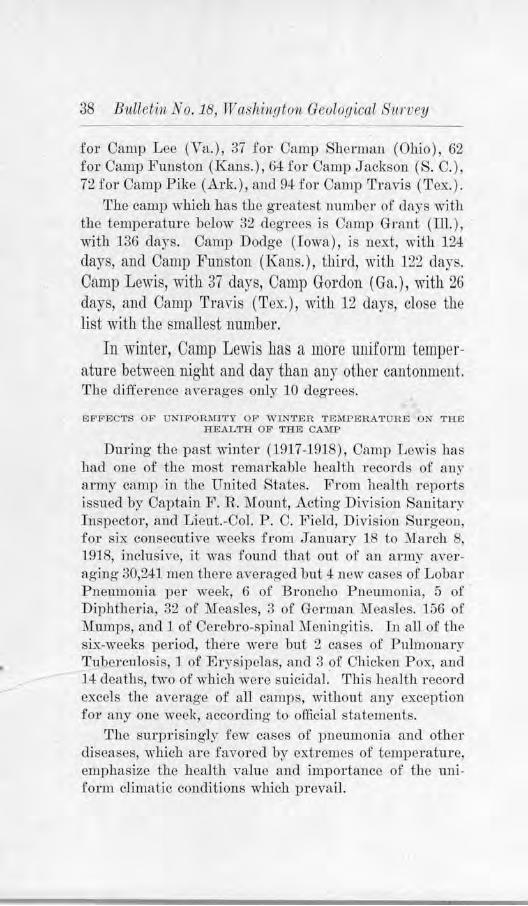
During the past winter (]917-1918), Camp Lewi ha had one of the most 1·emarkable health records of any army camp in the United States. From health reports issued by Captain F . R. Mount, Acting Division Sanitary Inspector, and Lieut.-Col. P. C. Field, Division Surgeon, for six consecufo0 e weeks from January J8 to :March 8, 1918, inclusiYe, it was found that out of an army averaging 30,241 men there averaged but 4 new cases of Lobar P neumonia per week, 6 of Broncho Pneumonia, 5 of Diphtheria, 32 of Measles, 3 of German ·Measles. 156 of Mumps, and 1 of Cerebro-spinal :Meningitis. In all of thE' six-weeks period, there were but 2 cases of Pulmonary TubcJ·culosis, 1 of Erysipelas, and 3 of Chiclrnn P ox, au.cl 14 deaths, two of which were suicidal. This hea1th record excels the average of all camps, without any exception foy any one week, according to official statements.
The surprisingly few cases of pneumonia and other diseases, which arc favored by cxh·emes of temperature, emphasize the health value and importance of the uniform climatic conditions which prevail.
The Country about Camp Lewis 39
EASTWARD LJ:.'IUTATIONS OF WESTERN ,YAS'EllNGTON'S CLll\>lAT.El
The moderacy of the climate at Camp Lev.is is distinctive only for western Washington and not fo1· the area east of the Cascade 1\fountains. The differc11ce bet\veen the two emphasize the part which tho Cascades play in modifying or controlling the climate. Rising to heights of 5,000 to 6,000 feet and more, these mouutaius act as a great barrier and prevent the free sweep of the winds from the ocean to eastern "\Vasbing'ton and tbel'ClJy prohibit the transfer of the tempcrahHe of the Japan current beyond the western slopes. In consequence of this the summers are hotter and the wintel'S colder east of the mountains than west, and the differences between nig1lt and day are usually greater.
THE RAINFALL OF WESTERN WASIDNGTON
The more abundant rainfall of western Washington as compared with the region east of the mountains is striki11g1y emphasized to the tnwoler. Leaving Spokane, wcsthound, the traveler soon passes into the sage-brusl1 plains of the Columbia Plateau. For mile afte1· mile not a tree is in sight, and the sombre landscape contjnues in its snmcness to the Columbia Ri,·er. Once the ascent of the eastem slopes of the Cascades is begun, the stunted tree mid the thicket appear. Tl1e trees increase in size • 1:rnd numhers with the rise of slope until at the summit allC1 on the western slope arc seen the dense forests. The tra,·elcr has crnsse<l from the semi-arid Tegion of eastern Was11ing-ton to the rainfall area of the western portion.
SOURCID OF THE RAINS
Practically all of the rai11 has its pl'irnary source in the Pacific Ocean. By evaporation, the westerly winds pfrk it up and carry it over the land areas, where if the temperature is prope1·1 jt wi11 be condensed as rain. It is fortunate indeed, for other reasons than those pertaining to temperature, that the rotation of the earth causes the
40 Bulletin No . 18, Waslti11gto-1L Geological Survey
winds in this latitude to blow preYailingly to the eastward. If the winds blew to the westward this would be a desert-like region, for in that case there ·would be no · adequate source for the moisture.
RAINFALL MAP
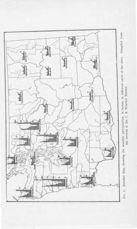
Fig. 3 how graphically tbe rainfall in different part. of Washino·ton. The height of the lines indicates the amount which a given place receives, and each line represents a month, from J anuary to December. It is strikiug how much longer the lines are for the western part of the state than for the eastern. It is equally striking- how much longer the lines are for the winter months, such as November, December, J anuary, au<l February, tlian for tho . ummer 1nonths. This illustrate the hvo cllief points about Wa hi:ngton 's l'a infall : the area west of the Cascades receives much more than the area to tlie east, and most of the rainfa11 occurs during the winter months.
For the difference -in Tainfall betwceJJ eastern and western ,Vashington, the Cascade :Mountains a1·e large]., re po11 iblc. When the westerly winds 1·each the Cascades they rise in ordm· to pass ove1· them. Iu rising the\,· expand and become chilled and are forced to deposit much of their moisture on the western slopes. Wl1en they reach the summit and begin their descent of the eastern slopes they hecome warmer and as the>' do so they precipitate loss and less moisture anc.l e"entnally become evaporatjng- rather than rain-giving. Pasco, at the eastern foot of the Cascades, receives less than seven inches of rairrfa.11 per year on the average.
SEASONAL DIFFERENCES
The seasonal differences in rainfall are due primarily to temperature conclitions. In the winter the land area is sufficiently cool to cause the winds to condense their moisture, and storms arc more frequent. In the summer the heat of the land warms the moisture-bea1fog winds,
c= 0
~~ ---~ - .... "B 0
"' "' ,_ 'O C. ..
0 >, c., - "' .c .. := Q) 0 .c E -Q)
:5
42 Bitlletin No. 18, 1V ashitigton Geological Siwvey
increases their capacity to hold moisture, and thereby prevents rainfall.
At Camp Lewis, 80 per cent of the precipitation occurs from October 15 to l\iay 15. The greater part of this falls during the night, which gives many clays of no rainfall dm·ing daylight or several hours of fair ·weather . During J nly and August there is usually less than one inch of rain for each month.
LOCAL DIFFERENCES
In western Washington it generally holds that dis
tance from the Pacific Coast and altitude above sea affect the amom1t of rainfall of a gi vcn place. Of two points having the same elevation, the one which is nearer to the Pacific Coast receives the greater rainfall. This is illustrated by Aberdeen and Olympia, which have the same altitude. But Aberdeen is nearer the Pacific Coast by 40 miles than Olympia, as sho,V11 on Plate II, and receiYes an averao-e of 85.5 inches, while Olympia r eceives 55 inches.
Of two points situated the same distance from the coast, the l1ighe1· one has the heavier rainfall. The western slopes of the hjgh Ol~rmpics, fo1· example, have more than 1.20 inches of rain, but the lower Willapa Hills south of Aberdeen receive from 60 to 100 inches.
In some cases altitude is a more important factor in inAuencing rainfall than distance from sea. Many points near the summit of the Cascades receive more tbim 0 jnchcs, as compared with Olympia's 55 inches and Tacoma's 42 inches.
The rainfall at Camp Lewis is undoubtedly a little greater than it is at Tacoma and considel'::tbly less than jt is at Olympia. Forty-five inches is a close estimate. Jf the C<lmp were at Port- To,vnse11d1 in the no1·thern part of the Puget Sound Basin, the rainfall would be less than half what it is at the present location. Port Townsend has an average of only 20.5 inches. But Port Town-
The Country about Camp Lfiris 43
seud is scarcely any farther from the Pacific Coast than Camp Lewis and its cle,·ation is about the same. Then why this marked difference in precipitation! There ai·e two causes for this: the c.linction of the prevailing winds, nnd tbe position of Port 'rownsend with respect to the Olympics. (See Plate IL) The wintls of Puget Sound blow more from the sonthw·cst in tho winter than from the west, antl this makes Port Townsend directly in the lee of tho Olympics. The southwest slopes ot the Ol~pics, the ref ore, catch most of the moisture and but little is left for places sit,rn led northeast of the mou11tains cit low elevations.
RAINFALL AT OTHER CANTONMENTS
Although Camp Lewis and vicinity receive a generous rainfall, it is interesting to note that at least four other cantonments in the United States receive a still greater muou.nt. The average annual precipitation at Camp Gordon (Ga.) is 50 inches; at Camp Pike (Ark.), the same; at Camp .Jackson (S. C.), 47 inches; nnc1 at Camp Dix (N. J.), 46 inches. As has been stated hei·etofo1·e, the rainfall at Camp Lewis js probably about 45 inches. This is equalled at Camp Taylor (Ky.) and Camp Upton (~. Y.). Camp Travis (Tex.) has the least rainfall of all the cantonments, the amount there being slightly in excess of 28 inches.
The number of days with .01 inch or more of rain ,n-crages 155 per year for Camp Lewis, which is 2~ more than !'or Camp Upton (K. Y.), the next in the list. Camp Fm1ston (Rans.) has the least number of rainy clays, aYcraging· hut 65 each year. The comparafo·ely la1·ge uuruher of rainr c1a?S at Camp Lewis is the only objectiona lJle fcatul'e of its cliniate. This, bowe-ver, is partly compensAted b~· the gentleness of itR rains, the mod<'rntion of the temperature during the rains, and the ease with which the gravel formation at the Camp drains away th<' waler, thus preventing flood conditions which
44 Bitlleti11 No. 18, Washington Geological Siwvey
ha\7e seriously affected other cantonments. Severe thunderstorms, accompanied by "\v:incls of mgb velocity, such as occur in the middle west and eastern states, are pTactically unlmown at Camp Lewis.
SNOWFALL
Snow js infrequent, and when it docs occur, the fall is usually light. During 17 years of observation the amount has averaged about 16 inches per year. This takes into account all that falls, even though much of it melts away promptly. This is the least snowfall of any
of the cantornnents north of the la titucle of St. Lorri . Camp Custer (:Mich.) bas the greatest, 51.5 inches, ancl Camp Trin·is (Tex.) the least of all, 0.3 111ches.
Not over 50 miles away from Camp Lewis, in tho Ca. cadc Mountains, the snowfall js much heavier, 100 inches being 11ot unusual. DmiJtg· 0110 winter season 48 feet was recorde(l Snow which falls in the mountains lingers untjl late smnmer, and muc]1 of it is perennial. This pro\7ides a valuable source of water-supply for the streams during the summer when the rainfall is the least, :md gives rise to valuable water-power resources.
SULTRY WEATHER
Sultry weather is due to warm temperatures and a relatively high content of moisture in the air. In the easten1 part of the Un ited States, when the air on summer days has a high relative humidity, or whe11 it conta:ins almost as high a percentag;c of rooishu·e as it can hold, the perspiration of the body is not evaporated with the usual rapidity and the atmosphere seems depressive .. This sort of weather is called sultr~r.
In the Puget Sound Basin such days are rare. Tbe, summer months are comparatively dry and the relative humidity of the air, especially during the warm part of' the day, is low. At :five o'clock in the afternoon it.
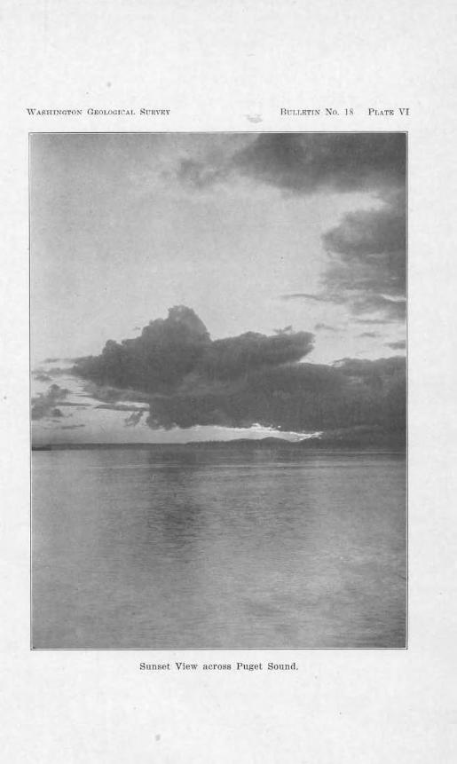
i\' ASHINGTON Q~}()I.O(HC'A I, 8 UHVEY Bri,LET11" No. IS Pr.AT& VI
Sunset View across Puget Sound.
+6 Bullef'i·n -:,,~o. 1 . TT'aslii11gl on Geological Survey
averages but 53 $10 at Tacoma, whereas in all of tho eastern cantonments jt ranges all the way from 57% to 73%, except at Camp T1·avis (Tex.), which has the exceptional average of 51 %.* H . ummer ·were a wet . eason in the Puget S0u11d Basin instead of a dry, the weather would be vcr., sultr~·, ancl although its temperature might not be exce ivolr wnrm, the dnys would be euervafo1g. Such is the case in the middle and eastern state on an occa. io11al day during the summer.
WIND TELOCITY
In the Puget Sound Ba ·in, near ea-level, 100 feet above the surface, the wind Yclocit _,. ranges from an a'1eragc of five m iles per hour <luxing August to seven miles per hour clnri11g .Jnnuar:v. A11 authentic record of a toxnado is mtlmown in Washington.
SUNSHINE
Tbo vicinity of Camp Lewis n.Yerages more hours of suushine during lbe summer than Camp Upton (X. Y .), and al:u10. t n.s many a. Camp D cvc1t (:~fass.) and Camp Gordon (Ga.). For .June, July, and August, the v icinity of Camp Lewis ha. averaged 795 hours clurilLg tllc 1G yea rs' record, Camp UptoJJ, 7J9 hours, and Camp Devens, 08 houl's, and Camp Gordon, 30 hours. Of all r ecords obtained, Camp Pilrn (Ark.) has the highest standing, with an rn,c ragc of 97-l hours.
Duriug- tile winter, on account of its rainy clu.11atc, Camp L ewis holds tbe lowest su11shi11e record and Camp Pike the highest. But in spite of this, its average minimum temperahu-e equals that of Camp Pike.
• All records on which these averages are 'based were taken at the same time In all pans or the country. Since 5 o'clock Pacrnc Time is 8 o'clock Eastern Time 11nd 7 o'c lock Central Time, lhese records do not represent the same stage of the clay, and the1·e!o1·e some allowttnce mu1;1t
be miu1e for the lllgher percentnges of the Easl.
The C'oiwtry about Camp Lewis 47
COMPARISON OF TH.El CLIMATE OF CAl','IP LEWIS WITH THAT OF FRANCE AND BELGm111
Thus far in this chapter cxclnsi,e att{'11tio11 has been clcYoted Io t11e climate of Camp Lowis and a comparison of the same with iliat of other National Cantonments in the United States. It appears from this comparison that the climate o.f Camp Lewis has many superior qualities.
In the .first place, it has no zero weather in winter; secondly, the temperature is nearly uniform in winter, there being no rapid or exb'eme changes whi.ch tax vitality; thirclly, the snowfall is light, and of sl1ol'l duration; fom-thly, the summers nre modorntely wnrnt without oppressfrc heat; fiftllly, there is sufficient difference bchvcen night and day io permit refreshing sleep at night and maximum efficiency during the day; sixt.hly, there arc neither to111acloes nor thunderstorms with attendant f1ood conditions.
The stay, however, of the soldiers at Camp Lewis is mostly temporary. After their vreliminary training they are destined for sc1Ticc in France and Belgium, where c]imntc will be as much a factor oP health and interest as here. For this r eason it does not seem out of place to compare b1-ie-Oy the climate of the two places.
Fig. 4- shows a map of France and Belgium placed upon a map of the northwest states 'with regard to latitude and relative size. From this it will be obser ved that their position corresponds to a position on the Pacific from southern Oregon to north of Vancouver, British Columbia. That part of Franco which has been the scene of the war's activities, li es north of the latitude of Camp Lewis. Paris would he Jocatcc.1 approximately on ili<' norll10rn bolmclary of ·wasbington, Verdun on a line wiih Vancouver, B. C., a1Hl Lens, Calais, Dunkirk. an<l Brussels still farther north.
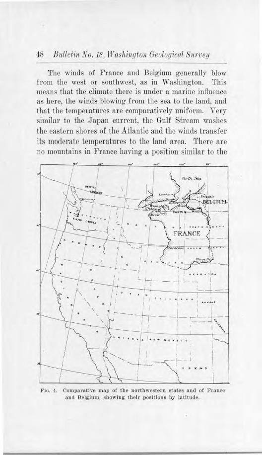
-!8 Bulletin N o. 18, Tr asl1i11.oto11 GPologicol )11rl'ey
The winds of France aud Bel0 ·imn gcncrallr blow from the we t or southwest, as jn ,r ashingt011. This means that the climate there is under a marine influence as here, the winds blowing from the sea to the land, and that the temperatures are comparatively Ulliform. \" ery similar to the .Japan current, the Gulf tream washes the eastern shore.· of the Atlantic and the winds tran fer its moderate temperatures to the land area. There are 110 mountains in France havin()' a position similar to the
,.,..
' '- I , • I
.......... -.......... . ..J-.J..J-
FlG. 4. Comparative map of the northwestern states and of France and Belgium, showing their positions by latitude.
The Country about Camp Lf1cis 49
Cascade Raugc, and so the marine influence is carried far i1tl,m<l1 beyond Paris. I11 the eastern and northcastcn1 parts of France, the elevations are higher, aucl Ulel'e is a ,,,idcr rallge of lemperatm·e, but it is less than woulcl ordinarily be expected for this latitude.
The winle1·s aro 11ot severe hut there is usnall)~ some mode1·ately cold weather. The number of days during the winter that the temperatm-e is conti.nuousl~ below :~2 degrees average 11 ai Paris and 11 at Arras,* as compared with two at Camp Lewis. In the vicinity of St. :.\Iilliel colder weather prevails, because the elevations m·e higher and farther from the coast. Snowfall is fair])! frequent frolfl No,~cmber to April, i.llclusi-ve, but is of lighter chai-acter over the lowlands. Hcavjcr and more frequent snows occm in the higher areas il1 northeastern France, ju th0 vicinity 0£ Verdun, St. J\Lhiel, Toul, and in eastern li'rance.
The sununers of northern France and Belgium are cool, wilh some mocleratel~- hot weather, bat without extremely high tem1)era tures. No tempera turcs abo,-e 100 degrees have ever been reco1·clec1 in France. In northern France the thermometer usually· registei-s less than 80 degrees during the day and below 60 degrees at night.
On lhe low plains in northern ]trance and Belgium the rainfall averages from 20 Lo 30 iucl1es, ·whik in th<' Vosges :.\Iounta ins in nortlleastern and eastern France it ranges from 60 to 70 inches. lt is a little lrnavier in tl1e fall and ear]y wi11tcr1 hut the minimum occurs in the spring. The rains are frequeut but are gentle and of short dmation. A. rainfall heavier thim one inch in 2+ hours at Paris is rare, and at Arras, on only 0110 da)~ in .Jfre years has there been a ntinfall exceeding orn~ inch. The amount of cloudiness is about the same as that at Camp Lewis.
• Anas ls near the no1·the1·n e11u oC the present battle-line. l\larch 1, 1918.
50 B'ltlletvn No. 18, TV ashing ton Geological Sitrvey
In general, it may be stated that tho winters are a little more rigorous and unpleasant than at Cnmp Lewis, with damp and chilly winds from the west and southwest. The days arc somewhat shorter than here and the nig-hts correspondingly longer. In April and 1'fa? the length of day increase rapidly, with much more sunshine and with light and rather frequent showers. The stunmers are pleasant. The days are moderately warm and the nights cool. In the latter part of June the days arc about J 6 hours long. The autumns are usually agreeable, with the rainfall a little more frequent and of greater intensity. On the whole, the climate of northern France and Belgium is very much lilcc that of Camp Lewis. Indeed, it is rno1·c nearl)' like that of Camp Lc·wis than any other camp in the lfn..ited States.
CHAPTER Y
.ANC'I1£NT CLL\LATl C ORA.NOE,·•
The present climate lrns not always bceu characteristic of this region. ,Just as Nature h.-1s brought about revolutionary chang·es in the laud forms so has she effected grc:1t changes h1 the climate.
FORMER PERIOD OF TROPICAL CLJl\IATE
The question is frequently rniscd as to how it is 110ssiblc to determine -what kiud of climate the earth has had in the ancient past, preceding the earliest written records. The method is by no means mysterious, ncitlwr is it as speculati vc as is popularly supposed. In the last century- or so, students of earth science hm7 e come to nnclerstan<l how the rock strnta of the earth were formed, ,mc1 how their ingredients frequent}~~ i11dicate ihe kind of conditions which cxisicd at a particular time. With this knowledge, some f a_cts which arc hidd0n to the casual observer n.re re,~ealed with surprising clearness to the investigator.
The coal beds that arc now being mined at Yarious places on the east and west Sanks of the Cascades, as at Roslyn, Carbonado, Black Diamond, or Newcastle, arc made up in part of palm leaves und branches. These indicate that at the time this material was accumulating a tropical or sub-tropical type of climate must have prevailed ii1 this 1·egion to permit the growth of this sort of Ycgetation. This particular period occurred ages ago, eYen before the present mountains were uplifted, for the coal beds m·c tilted and included in the structure of the mountains.
But the existence of this climate witl1 this vegetation was none the less real. Just how different the landscape appeaTcd then as compared with the present can be pichU'ed mentally by supposing that the present mountains
52 Bitlletin No. 18, Washington Geological Survey
were leveled, M:t. Rainier removed, and by substituting for our pre ent pines, fir s, a11d cedars, the palm type of vegetation.
Such a climate this region must have enjoyed for a long- time. Due to causes that aTe still problematical, a change to another extreme came, when instead of the temperature being tropical or sub-tropical there was a slow transition to a temperate and then to a frigid climate, which resulted in a large part of North America being over-ridden by an jmmense ice-sheet. This ice' heet was so exten ive that it i1rrnded the middle . tates as far south as St. Louis and beyond.
GLACIAL CLIMATE
It would be expected that the severity of the climate whicb wou1c1 make this possible would also make itself fcit jn the Puget Sound Tegion. This has l)een found to be true. An extensive ice-cap over-rode this region, tnmsformed umch of its topography and produced the graYel plain at Camp Lewis.
SOURCE OF THE J?UGBT SOUND GLACrE'R
The Puget Sound Glacier had its source in a snowfield somewhere in British Columbia. Acct1mulating by. degrees un<ler tbe influence of a climate which made snowfall exceed the melting of summers, the snow.field assumed inunense proportions and e,·entuallr, when its thickness became great enough to generate motion, it gave rise to a glacier. The snowfield had frozen to loose material on the surface, and so WI1s already shod with rock fragments when it assumed the nature of a o-lacier. Wben movement began, these fragments grooved and scl·aped and scratched the bechock over which the ice passed. The bare rock sm·faces of the San Juan I slands and at Victoria preserve many of these markings and in almost all cases they trend north and south. :Many of the stones found in the clay deposits throughout the
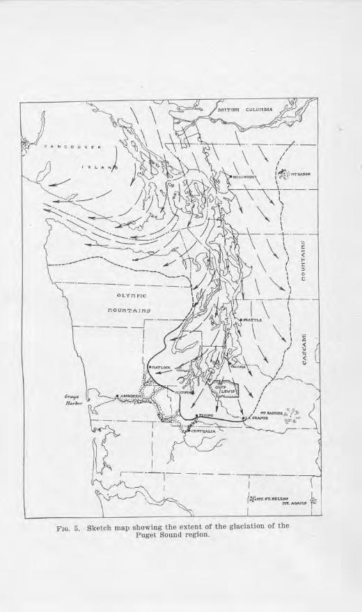
MOUrtTAJl'I.S
r·--·- ·-·-1 I
F10. 5. Sketch map showing the extent of the glaciation or the Puget Sound region.
r., .. < u "' < Q
5-l: B,ulletin No. 18, lVashin_qto,n Geological St1rvey
Pnget Sound country belong to nafo·e ledges in British Columbia, thus making it quite clear that the glacier came from that direction.
SOUTHERN Lil,fiTS OF GLACIATION
The great _glacier filled the Puget ou11d Basin, as shown jn Fig. 5, from tbe Cascade Mountains on the east
to the Olympics on the we t, a breadth of 50 to 60 mile . . The deposits of debris, which afford trace of where the ice moved, arc found llirougLout the Puget Sound country to a point about 20 miles south of Camp Lewis, and about 15 mile outh of Olympia. From the north line of the state this is distant 150 miles. How much farther north was the source oJ' Hie glacie1· is not exactly kiwwn, but these proportions in Washi11gton suggest the imme11sity of the ice-sheet.
N or01 of lbe Olympics, Vancouver Island was overriddeu, tLe Strait o:f: .Tuan de Fuca was fiUcd, and the icC' projected into the Pacific far enough to form nn icC'hridge from the Olympic P eninsula to 1he southwest . ·bor es of V m1couvcr J sla11d.
THTCKNIDSS OF THE ICE:
The ice i known to have been sufficiently thick 11ot only to fi)l the b:oughs of Puget Sound, which off Pt . .Jefferson is nearly- 1,000 feet deep, but to have o,crtoppod some hiJls or small mountains over 3,000 feet high. This shows that the ice was at least 4,000 feet thick, and prohn bly it was considerably thicker, in order to gene1'ate tho necessary motion to o,-er-ride the rough sm·face of l11e Hrca.
THli: RETREAT OF THE GLACIER
Th<' molting back of the glacier is spoken of as itH r0trcaL. This could not have taken place m,til the climate changed from a glacial to one approximating t]1al of the present. This change probably was gradual, so that by degrees the glacial front retreated. The time involved was ncccs arily long, probably thousands of years.
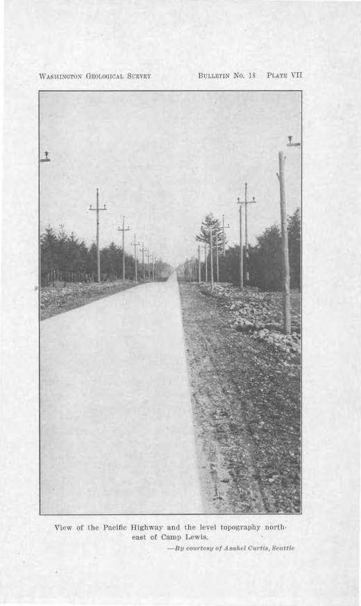
WASlllNGTO~ Gb:01.0GICAL SunYEY BULLE1'IN NO. 18 Pl,AT•: VII
.l
View or the Paciflc Tlighwny and the level topogrn1>hy north· east of Camp Lewis.
By cottrt,·~y of ,l saltrl Curtis. Swttlr
56 Bulleli11 i-o.18, nrashin,(Jton Geol.o.(Jical Survey
Tho melti11g of ·uch an immense field of ice, which was being constantly fed at its source by newly fallen . now, must have created great floods of water. The courses followed by this outwash, when the ice ,vas at jts maximum limit, arc shown in Plate VI io ha,c been by tributaries to the Chehal is River 1rnd thence to Grays Harbor and the Pacific Ocean. Enormous quantities of silt, and, and gravel were either carried in uspen ion in the str eams or r olled or moYed along the bod of the treams until they were buried by the onrush of other
O'ra,el . The great gravel benche, now exi ting a.long the Chehalis River and its trjbutarics represent the rcmuants of what was au enormous fill in the valleys.
CONSTRUCTION OF GRAVEL PLAIN. AND HILLS OF THE CAN'rOm{ENT
It was during· tliesc r etreating stages of the glacier that the gravel flat a11d hills of the Cantonment came into existence. The amount of debris carried in any glacier is tmequally distributed. Consequently, upon the melting of tl1e ice, tbe land surface that was formed from these deposits was left incg-u1ar, with hills and ridges of un-equal height and dissimilar form, and pond-basins and miushe. promiscuously distributed. Such inegula1·ity was in some cases increased or modified by the original irregularities of the old surface, or by reac.lvmrnes of the ice-sheet, or both.
The hills south of Camp and to the north are of glacial origi11. They are made up of debris of glacial character. The intricate S~7 stem of trenches on the hill slope just south of the ba1Tacks were dug in this material, which geologists call ,r;Tacial till. :Much cliiliculty "Was c-xper ie1rnecl by the solclic1·s in digging, due both to the compactness of the material and the numerous pebbles and cobhlc tones mixed ,Yi.th clay. ommonly this ruatcrial i.s lmown as "hard-pan." For an army to intrench itself in such a terrain under lire would be well niO'h
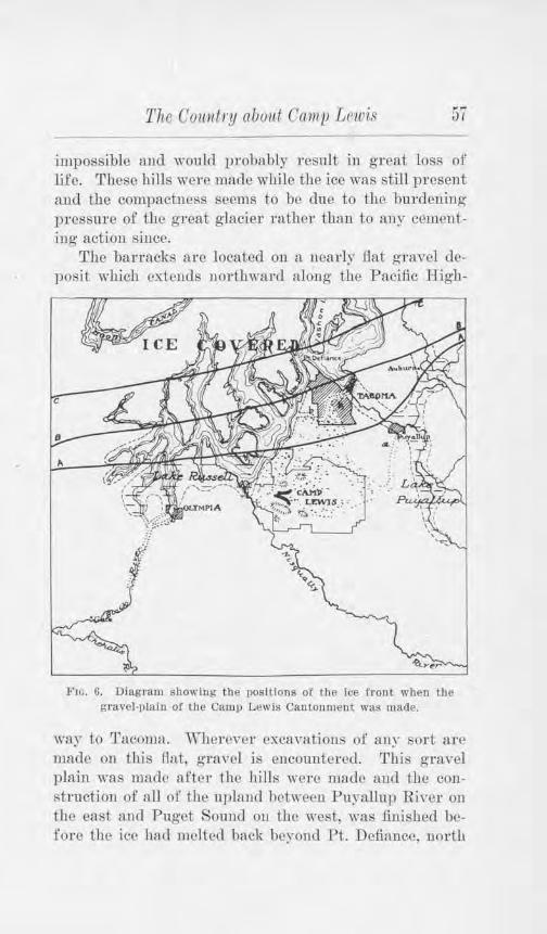
The Country about Camp Lnvis 57
impossible ::tnd would probabl~v rnsult 111 groat loss of lifo. These hills were maclc while the ice was still present and the compach1ess seems to be clue to the burdening pressure of the great glac1er rathe1· than to anr ceruenti11g action since.
The barracks are located on a ucarly llat gnwcl deposit which cxtcuds 110rlhwanl .dong the PRcific High-
Fw. 6. Diagram showing the positions of lhe ice front. when the gravel-tilaln of' the Camp Lewis Cantonn1ent was macle.
way to Tacoma. Wherever excavations or an~· sort are made 011 this f-lat, gra vcl is encountered. 'f his gravel plain ,vas made after the hills were mad<:' aucl the construction or all of the upluud hetweell Pu)~anup Ri,·er 011
the east au<l Puget Sound 011 the west, was fu1isbe<l before the icl' ba<l melted hack hl'rond Pt. De.ffancc, north
58 Bitlletin No.18, Washi11._qton Geological S'l£rvey
of Tacoma. In order to make clear how thi. js k11ow·n, the reader's attention is i:Jwited to Fi.g·. 6.
This diagram shows th.rec stages in the retreat of the ice after it had melted back from the Camp Lewis Cantonment. The lino A-A shows the position of the front of lho ice at one stage, B-B at a later, and 0-0 st ill later. When the front of the ice lay along the line A-A, the waters of Puget Sound were shut off from their northward connection with the ocean and a lake gathered
i11 front. This lake lay to the west of the Cantonment in the vici11ity of Camp Lewis am1 has been named Lake Russell. After the waters had risen to a leYcl of alJou(-160 feet ahoYe present: r;ea-leve1, they found an outlet over the lo,v djvide southwest of Olympia and discharged, as indicated on the diagram, by way of Black River to iho ClJ0halis RiYcr, and thence to the ocean. Anotber reference to Fig. 6 will show that the sh-cam in the Puyallup Valle~-. to the east of the Cantonment, was also obstructed b~- the ice imd another lake formed, cnllecl Lake Puyallup. This lakl' r eceived drai1rnge from the melting ice to the n01·th, from the glaciers i11 the Casca<les, ancl from the glacil'rs on :Mt. Rainier.
\Vl1er c did the watt'rs of t11i , lake escape? This invoh·es the inrpo1·tant point of the origin of the gravel at C.arnp Lewi. . The ,vaters rnir;l'd until the:, r eached nn ouUet southwl'st of Puyallup, as indicated in the figure, at al>ont an c•levation of -+00 feet abo,c present flea-lC\·el. The site of 1hl' present town of Puyallup was then under nearly- 350 feet of water. Tl1ese waters pur-ucd the course "a," crossed the Cit mp LcwiR area to
Lake Russell on the west, .and thence escaped by way of Olympja nnd the Blnck River outlet. Tu passing ncrosi:; the Cant01rn10nt the. e \Yaters, together with those from the ice-front itself, distributed an immense amount of grnvcl and gradually built up ihe b1·oad gravel flat around the scattered hills of glacial debris. .AJJ of the
The Country abont Camp Lewis 59
graYcls of the Cantom11ent were dcpusitct1 at tlw; tinw. nnd Lheir l'Ouncle<l and wwn ch:u·acter js due to their rolling by the lo1Tenlial waters. SeYcral 11 kettle-holes'' appear here and there in the• sui·face of the Clat, which show that huge ice-blocks became isolated from the g·lacicr, washe<l out, and later w<•rc partia1lr or wholly buriNl by the gravels. After rucH ing, depressions were left.
As the ice-front recetlcd northw·ard lo\\'Cr grouud was 1mco,·cr<.'d in the , -icinity of i~tcil~tcoou1 arnl tJJe waters were diYcrtc<l along Clover Creek in the direction of Chambers Creek. A wj<le channel was cut by the large volume of water, and it is withru this broad channel that the present small Clover Creek, 11orth of the houndary of the Cautonment, winds aimless!~·.
Still farther recession ot the glacier to the line B-B uncovered a lowcT outlet for T1ake Puyallup at the presmit site of Tacoma. This outlet is the lo\\' col uow followed by lhe N' ortbem Paci fie Railwn>' an<l the Pacific JJjgbway in leaving Tacoma. for Camp Lewis. It has been mune<l the South Tacomn outlet and its position is shown in the diagram at ((l>."
Once the ascent is made from tl1c lower business section to this col, one finds hiniself iu a \vido1 flat-bottomed n1.1ley which curves southward to South Tacoma ancl U1en westward to Steilacoom. This huge channel, 75 lo 80 feet deep at Tacomn, was cut by the escaping wntt>rs of Lake P uyallup as they purstwd this course to tl1e ,·icinity of Steilacoom, where they emptied into Lake Russell. The gravels which were obtained from the g-lacicr autl from cutting· this cLanncl were deposited us a gn•at tlcltH hi Lake Russell, and it js these gra,·cls which :ne so well cx11oscd iu the large gravel pit at StciJacoorn.
·when the South Tacoma. outlet was unco,·crecl, the older outlet "a" at Puyallup was abandonetl, for the n0wer outlet ''11" was lov,Pr tlia11 "a'' hy 90 feet. The
60 Bitlletit1 No. 18, 1l7 a.sh-i11gton Geological Stirvey
flood of water which this sudden drop permitted from such a large lake as Lake Puyallup is easily imagined; like'1.7:ise its power for rapid cutting.
By referring ag·ain to the diagram in Fig. 6, it will be observed that while the outlet "b" was being used, the front of the ice must have had a position somewhere between Tacoma a11d Pt. Defiance, for just as soon a,s the glacier' front had receded to the ljne 0-0, north of Pt. Defiance, Lake Tacoma merged with Lake Russell by way of The Narrows and assumed Lake Russell's level, 70 feet lower. Outlet "b" was then no longer used.
The construction of the Camp Lewis area was them complete and the sound of torrential rjvers was no longer to be heard. Its glaciaJ history was at an end. Save for slig·ht changes, its .urface has remained essentially the same ever since.
Lake Russell c011ti11ued to exist to the west, east, and north of P t. Defiance until the ice front had melted northward to the Strait of Juan de Fuca, when its union with the ocean was permitted. Then the ,rnters of Puget
ound changed from fresh to salt-water conditions.
OR!GL'< OF TKl'l LAKES
American Lake and the other lakes which occur in a successive series north of Camp Lewis owe their origin also to t.he glacial epoch. There appears to have been a former valley along the line of their position which was partly filled wit.h ice when the gravels of Camp L ewis were bei11g deposited. The gravels were washed around the stagnant ice-blocks until they were buried and then more gravels were distributed farther westward, developing a ne:nly level plain. When the deposition ceased and the ice melted, inegular depressions were left which became the basins for the present lakes.
The Oowdry about Camp Leicis 61
OTHER GLACIAL EPOCHS
Bcucalh the glacial c..leposits which occur so wiuely in the Puget S0u11d area, there is a still older glacial deposit which is separated from the one above by old soils, peatheds, and rnsty gravels. Thjs r elat ionship is showu along some of the cliffs of Puget Sound. The presence of the old soil and peal between t.he two deposits shows that two different glacier s haYe been in the Puget Sound Basi11 and that enough t ime intervened between the two glacial epochs for the climate to become warm and vegetation to cr eep back into the area. The rusty gravels also are thought to show weathering during a warm climate. And so it seems safe to say that this region has experieuced at leasl two epochs of glacial climate, during both or which lhe liie suffer ed scriousl~· -
In the middle states there arc c,~idcnces of at least 6Ye distinct glacial invasions r ath01: than two. And the time between each oue was much longer than the t ime since the last, an<l the inter-glacial climates were at least as warm. During each inter-glacial epoch tl1e land was rcinJrnhited with plants and animals, onl~· to be destroyed or driYen southward b~· the extr eme coltl of the next glacial epoch.
That evidences fo r only two glacial epochs ba,·e been found iu Puget Sound localities should not be taken to mean that 011 ly two occurred. It would seem that if tlw climate became sufficientl~· cold to cause five glaciat ions as far south as fowa, 11issouri, and IlJinois, Puget Sound was vrohahl>· similarlr affe~tecl. P c1·haps the e,·idc-uces of th(' older glaciations bin-e beL'll ohscurcd h~· the younger deposits or wholly obli terated.
LENGTH OF TIME SINCE THE LAST GLACIATTON
Just how long it lrns been since the last glaciutio11 it is impossible to sa~,. The best measure of post-glacial time for this continent seems to he the amoull t oi' recession of Xiagara Falls. Niagara Falls is lrno"11 to haYe
62 Bnlletin Ko.18, Wa ·Mngton Geolog1ical iirvey
corue into exislence during Urn closing stages of the glaciation which last affected that pa1t of the continent. Since that time the falls ha,~c receded some seven miles. Taking into consideration the present rate of recession of the falls and the factor which have affected the rate in time past, it has been estimated that . omcthing like
20,000 to 30,000 years have elapsed since their origin. If the change in climate which caused the Puget Sound
g1acier to melt took place at the same time as the change in the eastern part of the continent, then we might assign the above figure to the length of post-glacial time in the Puget Sound Basin.
During post-glacial tlme, the Puget Sound Basin has been at '"'fl.rying heights above sc_a-level. Fragile marine shells occurring in a bed beneath oil have been found up to 290 feet above sea-1evel, showing that for at least a brief time the land was lowered relative to sea-level to that extent, and subsequently uplifted. This would have submerged the place where the banacks at Camp Lewis are built, but not the borderiJ1g hills. The absence of any quiet wnter deposits shows that this was only for a brief time geologically, althoug~ if measured in terms of a life-time, it may have lasted a genorati.on Ol' more. Wavecut terraces as wide as 50 to JOO yards occul' (Juitc commonly along the shores at a height of ahout 30 feet above the present waters, showino- that Urn waters of the .. ound were approximately nt that lc,·cl fo1· some time.
Deltas have been built :mcl extended a cousideral>le distance at the mouths of tl1e Puyallup and Nisriually Rivers, lakes 011 the upland ba,~e been p:utially filled with sediment the bod of American Lake has been . iltcd, and peat has accurnnlated in marshes and swamp , as below the outlet to Lake Sequalitchew. The upper few feet of the glacial material has been somewhat weaLbered and stained and made inLo soil, and the land reclothod with vegetation of various kinds.
CHAP'l1ER Yl
ael\lAN lilSTORY OFT.HE OAolP LK\VIS RIDGI ON By E1rnoxn S. l\lE,\XY
The vicinity of Camp Lewis has an interesting history. The 1frst ]1omes of white men to be established on Puget Sound were located there and for a dozen years there seemc<l great likelihood that ilic reg-ion wonkl become British rather than American tenitory.
During the period of discovery, exploration au<l occupation, four nations-Spain, G1·cat Britain, Rus!'lia and the United tates-songht the ownership of the Paci.fie KorthwesL In U1e Yery -year, 17~12, iiL which t.he United Stat<'s established claims hy Captain Robert Gra?'s discovery of Grays Ilarbor and the Columbia River, the British and the pauisb govel'llmcnt were settling the conflict ov<'r their rival claims. The Spaniarrls withdrew soutlnnud to the coasts of California tmd the British remained active as to their ch,ims along the northern shores. Tbese claims were in confJict with U1ose by the United States and Russia. The American claims were basC'd 011 Gray's discovery of the Columbia River, on Ll1e Lewis and Clark l~xplori11g Expedition, 1803-1806, and on the establishment of the fur trading post on Fort Ast01·ia HI- the m011th of the ri,er, 1811. The Brilish had also e.xplorecl and had established fur hading posts on the upp<'r Columbia River.
During the '\Tar of 1812, the British l)ougbt the American fort at Astoria, bnl hy the terms of the treatr of Ghent, 1814-, which ended tLe war, it was made clcl'lr that Astoria, as a settlement, was Aincrican. The two governments made a treaty in 1818 providing that the Pacific Northwest should be open to the citizen!; and subjects of hoth powel's ou equal terms for a period of ten years. In 1827, just before the ten-year limit came to an end, another treaty was signed ii1 order to extend the l'eature
6J Bulletin N o.1 , Trashi11oto11 Geological Surrey
of joint occupancy indefinitely. :Either 1latiou could encl this agreement by gi vi.ng the other one year's notice in writing.
All this time, Russia ·was building fort m1cl trading posts in what we now know as Alaska. They also claimed the lands southward along part of the shores jointly
claimed by Groat Britain and the Uuitecl States. That was protested by tho United State when the Momoe Doctrine was announced in 1 23. In the pring of 1 24:, Ru. sia and the United tates macle a treaty :fixing the boundary between their claims at 5-1:0 40', north latitude, and in J 25 Russia and Great Britain made a similar treaty. This eliminated Russ ia froru the claims and left Great Britain and the United tates as unclisputecl join tow11ers of the Pacific Xorthwest.
The Americans practicallr di sappear ed after their post at Astoria was sold and their claims were held alive tlwough gove111me11tal diplomacy. The Briti h incr eased their number of trad ing posts, which were doin"' n successful husu.1ess. Thi.s work was begun by the Kor th West Compau~ of Montreal, but in 1821 that compan~· was ah. orbed by the older Hudson's Bay Compan~'. The name of A.stori.-t had been changed by the Bdti b to F,ort. George, in honor of their king. lll J 25, the he::idquarter s of the Bri t ish trade we1·e mo,,ed from Fort George to a uew post farther up the Columbia RiYc1· ·which thc;v named Port VancouveL Their fur trade centered there.
"\Vllcn it was decided that the furs, harvested along the bank of the Fraser Ri ver and its tributaries, could hest lJc liaudled by a cent-ral post, Fort Langley was esta b-1 ished near the mouth of the Praser RiYer in 1 27. For t Yancotwer till r emained h endquarLer s. F or t Langley could be r eached by vessels go ing down the Columbia River, hy ·ca to the trait of Juan de Fuca and t.b.cncc up the Fraser River. Vessels were 11ot a lways to be had, l1owevcr, and frequent trips were made overland.
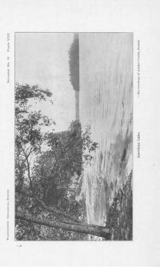
H
~ g ,,, i '
~ ;:.. "' I-j
i:..
:: IS
00
-:., -'<
"' ci z .,
"1 .... 0 ;;:, .. ~ ;..
;,;
~ :, ~
; <.,
;:. ~
I
-3
66 B11lletin Nu.18, TVashi11gton Geological Bnrvey
Canoes were pad<llcd and poled up the Cow1itz River to about tbe present site of Toledo and from there a portage ·was made to Puget Sound, where Indian cauo0s were secured for the rMt of the jom 11ey to Fort Langley.
The Indians could not always be depended upon and m ract !hey hnd to be ptmished for an attack on the firnt traders, iil 1 28. The e conditions caused the Huc1 on's Bay Company to decide upon establishing another post or way station near the head of Puget Sound. Thu arose the famous Fort Nisqually or Nisqually Ilou e on the grouucl nm\' occupied by the Dupont Powder Works. Tn the spring- of 1832, Archibald McDonald, a chief trader of the Ruel on 's Bay Company, whilo on a trading hip, p icked on N isqually Bay as a good place for the proposed post and left there Pierre Charle , William Onvric and one other 1~an willi a few blanket., a couple of k:e~. of potatoes and some garden seeds. The next spring Chief Trader :McDonald 1·eturnecl and in the usual spirit of car efulness of the Hudson's Bay company he made the first entry in a book called ".Journal of Occunences at Nist1ually" as follows :
":M::i:r 30th, 1 33, Thursday. Arrived here this after-110011 from the Columbia with four men, four oxen and four horse , after a journey of fourteen days, C'xpectin~ to have found the chooner Vanconver lying here. She sailed the af ternoon of the same day we started, with t rading goods, provi ion , potatoes, seeds, etc., hound for Nisqually Bay, where we hav-e now determined, should ever ything come up to e:xpectatiou, to locate an establi shment."
Ther e was with this first party a young Scotch surgeon, ,Villiam Fraser Tolmie, who was on hi way for service with the more 11ol'theri1 po ts of the company. The ser ious illness of Pierre Cl)arles kept him at Nisqually Col' some time. During that t ime the young doctor made a number of botanical excursions. On one of these he took Indian guides and attempted to climh Mount
The 001111/ry about Camp Lewis 67
Rainier. He succeeded in ascending one of the foothills overlooking ihe glaciers on the larger mountain. That little mountain is now called Tolmie Peak aud his diary of the trip is the prized record of civilized rua11 's first approach to the great mountain.
Chief Trader :McD01rnlcl <.lid uol stay long at Xisqually House. He had al.read.~- requested rctin~ment for age, and soon he was relieved hy Chief Trader Heron. The new trader did not like the location selectctl. Ile explored the shores as far as Whidhey Tsland and later decided to build the fort at the water fall where Tumwater uow stands, near Olympia. A band of Indians arrived at N"isqually for trade and would go no farther. rr hat incident decided the case and N"isqually House became the first settlement by white men on the shores of Puget S0m1d.
'l'he new fort served its purpose well from the very beginning. ·when it was three years old an important occutTence was recorded in the journal when the Hudson's Bay Company steamer Beaver arriYed for work on this coast. r1.111is l1istoric boat was the first steamboat to ply the waters of t.be Pacific Ocean. The fur trade was greatly stimulatecl by this new means of tnmsportatiou and of course the Indians were profom1dly affected by such a manifestation of the white man's power ~ls this great "fire canoe".
The Hudson's Bay Conq:rnny men at !J1 ort Vancouver bad giYen attention to lumbering and agriculture from the foundation of Uie fort · in 1 25. Similar1y, those at Fort Langley had fouml fish packing a good addition to their regulaT fUT trade. :N"isqually House was to become an agricuJtmal cc>nter. One reason for Chief Trader Henon 's dissatisfaction with the site was the poorness of tho soil on the south side of the Sequalitchew Creek where the warehouse had bee1l built on the beach. '11here was better soil on the north side of the creek but that
6 Bulletiu No. 1 , l fasl1in.r;tou Geological Survey
would necess itate an expensiYe bridge near the mouth of the creek to the only suitable place on the beach for the warehouse. A road was built from the ·warehou e on the beach to a level tract abo\'e. There the fiTst fort was constructed. near two large oak trees kuown a "The Twins". The sunken outline of the old stockade ma~· still be een and some evidences also of the first fruit trees and garden site. These old relics of the beginnings of civilization arc now mingled with uch sicrns as "Nitro-glrcerine-Beware ! " of the powder work .
In a fow years tho fort was moYecl a mile to the eastward to l:>e nearer a ource 0£ fresh water and the new fort there erected was 1.u-ger and more sub tantial. It also gave better command or the expamling prair ie whe1·c tbe propo ed agricultural enterprise could be attempted. nfan~· of the old Hudson 's Ba~· ompanr officers were opposed to such exp0rimeni.s. "'\, e a re in the fur tr1-1dc. Let those raise potatoes who wish to," was n form of the ir protest. Others urged the case until U1er won the day by the orgm1ization of the P uget Sound Agr i.cultural Company, about ]839. Chief }'actor John )JcLoughlin at Ji'ort Va11cotwer ·was gi,·cn charge of the new company, though the real supen·i io11 of its work was made from N isqually House. One of the larger experiments wns 011 Cowlitz Fann Prairie south of the present cit r of Chehalis. The care of cattle, sheep, hogs and crop begm1 to adcl largely to the actiYi tie of ~ isqunlly House.
Th is all :fitted well into the 1Jla11s of the Hud on 's Bar Company officers in the fa r west, or Oregon Com1try, which was still joiutl~· owned h.v the British and .A.mcricaJ1 . I n 1 34 the Amer ican mi. sionarics began to arrive ancl Dr. olcl,oug·hli n, the chief factor, directed them :outh of Columbia R i,·er. He continued that polic-:,~ as other missionarr parties ,u-ri,·ed and as ~isquall~· Hou e enterpri e incrca ed. He felt sure that wheu the joint
The Country about Camp Lewis 69
occupancy treaty was settled the British would get the Columbia Rfrer as the boundary.
News from these American missionaries and of the new British posts caused the "Gnited States Go,-,ernmeut. to awaken its interest. On K°'·erubcr 11, 1 3:3, Sccretarr of State ,Johu Forsyth instructed ·w'illiarn A. Slocum to vis it tbe setUements 011 the Columbia River ~rnd, without exciting British suspicions, to br ing back a report. He performed his mission a11d bis report ol' 1 37 included a strong irnd cnrnest plea for the rrutcd States to cling most fi_rml~· to Puget 1 'ouml "~hich he described as of great nllue.
The missionaries sent h.,- the :i\Icthodist .Episcopal Church had accepted the ac.kice o[ Dr. ~lcLoughlin and lrnd settled south of the Columbia, in the \Vil1amette Valle~·. The~· rccei ,·etl large rce11iorccme11ts in l 8-W and bcgm1 to expand. One of the 11ew missionary stations was (•stHb1ished at ~isquall~· House, where Dr . . J.P. Richmond mid wife and w·. H . Willson au<l wife were located. 'l'bongh this was contrary to the advice of Chief Factor McLoughliu, he gave orders lhat the missionaries should hC' heated with kimlncss. The home of Dr. R ichmo11<l was blessed br the birth of a bab~· bo~·, the first American ,Yhitc cl1ild born ou Pug·et Sound. This missiou 's WOl'k among the I nclians did not prosper all{l it "·as aban<loncd in 184~.
v\'hil<.' the Amcricm1 missionaries were nt work then~ tlw kC'eper of the journal recorded a most important visit hy n s(lnatlron of American vessels in command of Commander Charles \,ilkes. The official title of the party was Uuitccl States Exploring Expedition. F or four years, 1, 3 to 1842, this expedition sailed around the world making scien t ific explorations for tho Fnited States Government. The officers and men were cordially welcomed at N"isquallr House in J8+1. Temporary headquarte rs were fixed upon there while small parties were sent in
70 Bitlletin No. 18, TV ashing ton Geolog'ical Sitrvey
differnnt directions for the work of explorations. One of these parties, under command of Lieutenant Robert E . . Johnson, passed across the parade grounds of the present Camp Lewis on the way across the Cascade Mountains to inspect the missionary stations and mini_ng camp in the Walla Walla, pokane and Colville distr·icts. The report of that trip con titutes one of the valuable sources of early Northwestern history. It is one of the very fir t records we have of white men crossing those mountains.
Other excmsions were made from the Nisqually headquarters which gave rise to many such names as Budd Tnlet, where the present Olympia is located. It was named in honor of Acting Master Thomas A. Budd of the expedition. Another excursion passed through the N ar:wws and began surveys at a place which they called Commencement Bay, now known as Tacoma Harbor.
Independence Day was celebrated 11ear Nisqually House in ] 841 by the officers and men of the American squadron. There -was an imposing parade, harbecue of a beef, programme and vayjous sports. Thel'e was one casualty. A sailo r died from injuries received while firing a salute. I11 1906, the Washin<rton State Historical Society, assisted by other organir,ations, unveiled a monument with elaborate and app1·opriate ceremonies to commemorate the sixty-fifth anniversar~' of that first Fourth of ,July celebra tion in the Puget ound region. That celebration and the arrival later of American settlers gave rise to the well known name of American Lake. Commander Wilkes in charting aud uaming other places paid his respects to the British officers who had been k'ind to him. Mei eil Island he named i11 honor of Captain ,;villiam Henry :McNeil or the steamer Beaver and Anderson I sland was named in honor of Alexander C,wlfield Anderson, chief trader at NisquaUy House.
It is singular that the vicinity of Camp Lewis should have had a military characte1· ahnost continuously from
The Country about Camp Lewis 71
the beginning to the pl'esent time. The Uudson 's Bay Company and ihc Puget SoUll<l Agri.cultnral Company were semi-mi Litary in the ix methods. Chief 1~1 nctor McLoughlin was conummder-in-chief, micler whoru worked the various chief tnu1ers. Under tlwm were the clerks and lnstly wer e ibe companies of employees, usuall)r ca1lcd scnants. Oonmianclcr Wilkes nrni11tained military <liscipl i11 e \Yhile his men were in camps on shore. In 18+G, Robert Mills Jnskip, roral 1rnv}', 11.-wal instructor in her majesl~' 's sb ip Fisgard, established a regular camp nt :Nisqually for tllc instruction of junior officers. In 1 4-9, tbe United States Government established and manned l1'ort Steilacoom for p1·otcctio11 ag-ni11st Indian attacks or ou tbreaks. E,·cn during the long season of peace and qui<:'t after the Jndian dangers had passed, the State of ,,~ash ingion mainta ined Nat ional Guard encampments at American Lake in lhe summer n1011ths. The 1.i,irst Washington Infantry, United States Volunteers, was mobilized and drilled there for the Spanish-American War of 1898. In 1817, there came the greatest military quality the region ]ms knmrn b)· the construction and maintenance of Camp L e'\\7:i s.
While the British were still hoping for the Colunibia River as the boundary there came a shock to those at NisquaUy Ilouse when lhc Americans elected James IC Polk as President under the political battle c1·y of" Jl'jft)·four, Forty or F ight!" °"'T~n· was imminent hut was finail)' ..t"\"ertea by adopting the present boundary nnd giving the Puget Sound Country, including the vicinity of Camp Lewis, to the Americans in the h-eaty of 1846 .
. During the year previous to that treaty the ffrst real Americnn settlers arrived under the leadership of lfichael TToutmau Simmons and established themselves at Tumwater, near the p1·escnt Olympia. )fany of them were well treated and some of them were given employruei1t at Kisqnally House.
72 Bulletin No. 18, Wa ·l1ingto1z Geological Sarve11
The British did not lca\~c their establislunent as soon as the treaty was signed because the United States GoYernment had promised compen. ation for impTo-vcrnents and property taken. Dr. ·wmiam Fraser 'r olmie was one of the last officers autl be -fi11allr moved to Victoria, B. C. The claims for proverty aucl improvements at Fort Vancouver, Nisqually and elsewhere in the :Korthwest drao-0 ·ed along until September 10, 1869, when a decision of award was rendered b? which the United States was to pa)r to the Hudson' Bay Companr $!50,000 and to the Puget om1d Agricultural Company $200,000. The la t clerk in char0 ·c at Xisqually House was Edward Huo·gins. who became an American citizen and secured the site of Fort N'isqually as a homestead. It remained the Huggins homestead until the p roper t)7 became a part of the holdings of tbc company 110w operating- the powder work.
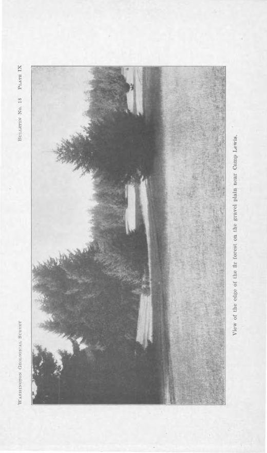
co ...
0
CH.APTER VII
NOTES ON PL.ANTS FOUNl) IN THE VICINITY OF CAMP LEWIS By GEOROE B. Rroo
The flora in the vicinity of Camp Lewis i of two distinct types-that of the level prairie and that of the ncighbo1·ing hills.
TREES OF THE HILLS
The hills in tbc main are covered ,vith a forest of Douglas fir. On the bor<leT. of this forest, especially on the ra thor steep slopes extending down to the prairie, there is a good deal of white oak. Oaks arc also fouud mixed with the young ffr in the forest and to a certain extent on the level prairie itself. Some fir trees arc found on the praiTie, too. A good many tr ees of both oak and fir are folmd in the vicinity of the bnildings of the Camp.
Tbc fir is the only co11i ecrous tree that js at all common in the immediate vicinity of the Camp. (Plate VUJ.) It is the commonest conifer in the Puget Sound region. It may be distinguished froru the othm: conifers ot the region by tho tbreo-pointo<l pro,jection (bract) which grows just outside of each scale of the cone. The mature cone is about three or four inches long. These cones are woody and arc f onnd commonly on tho ground in the forest. The leaves of tlie fu· are b~rne singl~·, not in clusters. They are an inch or a little more in length and about an eighth of an inch wide.
That the Douglas -fir is a natural covering of the grotmcl on the hills near C~mp Lewis is indicated by thelarge number of small trees and even very small seed-1 ings in the open places.
Occasional specimens of the western· hemlock are found in the ravines. The hemlock is readily distin-
The Country about Camp Lewis 75
guished from the fir. J ts branches arc soft and very flexible at their growing tips, while those ot the fir are stiff. The same is fruc of the growing point at the iop of ilic yom1g tree. r1~1Jc leaves arc of thrnc different lengths aml pro,iect oulward from the 1;,;vo sides of the braIJch, giYing it a flat appearance. The leaYcs of lh come out morn nl l around lhe stem, though sometimes lhere are not quite so many at tl10 top and bottom as at the sides. Tl.to len,-es of the hemlock are of three distinct lengths on each branch, while those of fir are practicall)· all of the same length. The kaYeS of the hemlock are rlecicledJy white uncler11eatb, so that the whole branch presents a whitish appeanwcc when newed from below.
A good rnnnr willows are found along the borders of the fir forest. In some cases the~· arc found among the fir frees f ru·th<'r back in the forest.
Some madrona trees are also found in ihis forest, especiall.v on Uie hills to I.hr north of the Camp. These trees are conspicuous Hnd attrnctive. They reach a height of 30 feet or mor<>. rp]H.' trunks of many of them are somewhat crooked. Occasionally one is found with a large 1mr1 nt the base. Tb(' bark peels off i11 smnll pieces, leaYing the rNldish urw bm·k of lbe stem smooth and ,vith a polished appeHrnnce.
Tltc lNwes are ove1·green a11(1 are thick and leathery. They ore from 31/:? to 5 i11ches long aml 11/:.! to 211:! inches wicle. The tree has large clusters of white Oowcrs in spring. Tlw heni<'s nre reel and freqncntly remain on the tree through the wi11ter. rrhcy ar<' not edible. but are among· the most conspicuous and atlractiv<.' nppearing lwnirH of !be region.
FOREST UNDERGRO\\''l'H
The lir forest, especially to tb.e north of the Camp, is o-f a rather open type. The undergrowth is not so dense as is the case in much of the forest of the Puget Sound 1·egion. The undergrowth in tLc f orcst to tLe south of
76 B1,lletin X o. 18, TV ashi,n.(Jfon Geolo,gical Sitrvey
the Camp is a little more abundant than that on the north. Salal is the commonest slnub forroiJ1g this undergrowth, though the common Oregon grape and the shin? Oregon grape are also abundant. The last mentioned species is confined more to the rathe1· open and dry places in the forest, particularly the crest of the ri se from the pra1ne.
Lichens, mos es and fungi are abundant in the fore t arotmd Camp Lewis. Thready lichen hang from the branches of the trees. There are al o several species of somewhat leaf-1ilrn lichens growing on the trunks and 011
soil. Various species of moss grow upon the tree trunks, decayu1g logs aud also upon rocks and soil. Practically none of these have common 11ames. One leafy liYerwort grows with these mosses on tree t runlrs and is moss-like in its appearance.
The woody bracket fungus frequently forms large, bard shelf-like growths on the coniferous trees. The hard convex upper portion sheds water r eadils·. The lower surface is creamy white in color and po1·ous, with very numerous holes, large enough to be seen with the unaided eye.
The leathery bracket fungus i thinner and is tough, rather than woody. It is common on trees other than coniferous. Its lower urface r esembles th11t of its woody relative.
TAL,LER SHRUBS
Among the taller shrubs growing in the forest on these hills axe hazel, Indian plum, service berry, buck brush (red root), a11d ocean spray. All of these lose their leaves in the autumn.
The hazel of this xegion gro,vs much taller than the familiar "hazel brush" of regions farther cast. It is commonly 10 to 15 feet tall, occasionally 30 feet in ra~inos. Light is probably a factor in this. It also grows more among the trees and does not form such dense
Th£' Country about Camp Lewis 77
growths in ihe open. lt does not produce nuts so abuudautlr as its easter11 r elHtiYc. In winter the stami11atc catkins form rather stiff bud-like projections upon the branches. In the earl? spring the shrubs are conspicuous because of the great abundance or slender dangling staminate catkins, shedding the yellowish powder? polle11. On careful examination at this season of year the small red pistillate flowers are fow1<l, usuall~· coming from the terminal bud of the branch. A little later leaves come. These are ,·eh·e~ to the touch.
The lu<liau plum hlossoms about the same time as the hazel catkins come. It has white flowers, borne along· a pendant stC'm only a few inches in length. The flowers come before the leaves hut are quickly followed by theru . The fruit is a bluish benr.
Buck hrush, or reel r oot, is a stout shl'ub 4 to 12 feet high. IL is collllllon in the edge of the forest ou the hills bordering Camp Lewis on the south and is also reported to be found on the praii-i.c. It has tbi.n lca,·es whose edges are Y<.'1·y finely SHw-toothed. Hs flowers are white.
The service berry is a white-flowered shrub 2 to 10 feet high. It bas a sml-111 black or purplish fruit which is sweet and edible. ·
Ocean spray is a ratllCr slender slll'ub whose stems do not grow strictly erect, buL curve gracefully outward from ilie center of the clump. Its numerous, very Rmall white flowers, produced in numerous large clusters, give it its common name. These graduall~· clrnuge to c1·cam color, then become darkeT and the brow1iish clusters of fruit and drietl bracts remain on the plants through the winter. The wood is rather tough and is sometimes known as ludian al"l'OW wood.
SMALLER SHRUBS
Salal is a shrub reaching a height of 2 to 4 foci i11 these woods. Ii is an cverg1·een. Its leaves last a little over a year, so that the old crop clo not wither until ilrn
7 Bulletin No. 1, 11'ashi11glou Geological SLwvey
11ew ones arc fairly mature. The leav~ ar c four inches or more in length and more thau half as wide as long. Their edges are very finelr saw-toothed. They arc tough and leathcr~r as are the leaves of the other bro<1cl-leaf evergreen.· of these fore. ts such as common Oregon grape, . hiny Oregon grape, evcrg l'ceu huckleberry, and pipsisscwa.
ala] has a whitish, l'ather sticky flower. The fruit is black and is about half an jnch in diameter. It i said to be edible, but is not ,·cry commonly eaten. It qualities as a food berry are certai11ly very poor as comp:ucd with huckleberries and blackberries.
The common Orcg·on gTape is a low shr ub ·with a ver.,short stem. In winter its most co11 sp icuoas feature is its long leaves, cul'Ving upward and outward from the stem. These lenvcs Juwe stiff lenfl cts, mTm1ged in pain:; along the central stalk, and m1 odd leaflet at the end. The leaflets arc very stiff and have a few short spinrs on them. When the lea fl et is looked at from the back it shows thrC'e rather pl'Ominent nerves all originating from the base of the leaflet The wood of the . tcm is distinctly yellow, though the outel' surface of the hark is h1·own. The stem grow from long tmderground shoots. T he Rowers nre yellow and the fru it i . a hlu ish ben~r, some .. times used for making j elly and pies.
The shin y Oregon gTape is much taller tba11 the com. mon 011e. H s lcin-cs ar c clis1·inct1y shiny and have sl1cn11er spines than its r elati\'c. It i sometimes called westel'll holly. Tl1e leaflets do not have the three disti11ct neiTes from the base. Many of the spccime11s ha\'C brilliant coloration of tl1e leaves, far stupassing the common ones in this particula1·. The flowers aud fruit of the two are similar. The unclerground portio11 of the tall onr is the 'ource of an official drng, ]mown as Oregon grape root. It has a distinct odor and a bitter taste.
The Cmmtry abont Camp Lewis 79
The dried leaves of pipsissewa also constitute an of ficial drug. They are evergreen and are from 111.j to 2 inches long ancl tllc wiclcst point is abo,~c the mi<ldlc of the leaf. The leaf is leathery and its edges arc snwtoothcd. The no,,·crs arc white or pinkish and 1he frnit is a dry capsule, splitting iuto live parts. This is a low plant. Its height does not usually exceed oue foot lt is Yery abundant in llic woods on the hills just lo the south of Camp Lewis.
Thero arc two hucklchcrrics fouml in this regi<m-ilie reel and the evt->rgreen. The one pro<.luci11g the r<'d henieH loses most of its leaves in winter. Frequcntlr a fC'w of the lower bnmchcs have eYergreen leaves. The twjgs arc greC'n and somewhat angled. This h; a somewhat straggling plant from 3 to 12 l'eet high. It grO\YS in ordinary soil in the woods, bnt is also common in the moss on stumps and fallen tree trunl-:s. Tlie berries arc small and are very bright red. 'l,hcy Hre rather ncid, bni arc good in pies.
The foliage or U1e evergreen hucl<lcberr~· is vcr? attractive m1t1 is much used for wu1tcr c1ccon1tions in houses. Most of the leans arc green, hut heautiful shades of red are sometimes touncl. '.rbe fiowers are rose color or nearly white. The lJcnics are acid but arc commonly eaten either raw or cooked.
Another broad-leafc>d evergreen shl'Uh, Pacllistima myrsi,nites, looks somewhat Like the evergrC'e11 huckleberry. It is smaller, hO\vcvcr, and its foliage is less attractive and its flowers and fruit arc inconspicuous. 1t is here mentioned by its scient.ilic 11amc because it has no c:ommon name.
'1\TOODY VINES
There arc a number of woody vines in these ,voods. The houevsuckle is an opposite-leaf etl ,·inc which climbs to the tops of the taller shrubs. It loses its leaves in ·winter. The tra"iling blackberr~· is a spiny evergreen
0 Bull pf in .1.Yo. 18, Tr' ashingto11 Geolog,ical 'nrri:ey
plaut with whit ish flowers. It trails over other low ,·cget~tion antl o,·e r the ground. lts Bo,,· ers m e white and its fruit is ed ible.
Th<' twin flower i1:i an e,·er<>Teeu Yinc fonuino· dense b . t:,
growths 011 the 0 Toum1. Its How01'S arc showy and rather drooping. The:· are borne in pairs on erect stalks.
The 1.ea vine is sometimes confused with thi , hut is rcadil r distingui, heel b)"' the odor of its lea,·e. ,rhcn crnshccl, also hr the fact ihat its lcaYes are hroader and its flowers much less conspicuou .
Kim1ikimiik is a prostrate, diffusely branched, woody pla11t, 1·ooting at the joints. Jt has whi te Ao"·cr s :rnd r ed IJt>rric~. 1t is common in the more open places in the woods south or Carup Lewis. It lc::w es a rc leather ~ and cnrgrecn and arc an official drug .
. HERB.\.CEOtJS PLANTS
The list of herbaceous plants in these woods is 11cc-0ssa ril)- i11co111plctc>, s ince it is based on a s ing-le Yisit rnndc i11 :ifarch.
A straw·bcrry is comrn011 in the open places. One of ih<' conmw11 fhi stles is also found. A false clandrlion, known also as cats-cal', is ,·en~ ahundrmt. It is r cadilly d is1 ingll i8hctl from lhc common tlanclelion h~~ the fact ilia t ib:; lC'a-,es are some,\"'hat hairy and ha Ye rom1tlcd lobes, while the cmmuon damleli011 has srnooth lNwcs with more angled lobes. Tts flower stalks hrancb wl1ilc il10se of the common dandelion do not.
A wild geranium is also cornmon in the open places. H iR a slow-spr cacling pl:mt whos<' somew·hat elongated fruits Rplit at matnrit~· into five parts, each part curliug 11])\\' lll'd.
Common yanow is also nhundaut. It nm~· be disti11-gui sllccl from other plants of the r egiou hy the fact that ils leaves ar(• dissected into m1mcrous small divisions, g i,~ing them an appeflrance that is sometimes de. cribed a.
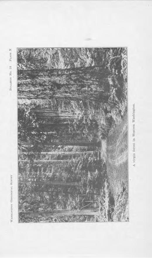
.. rl
ci z
)I 0 !: ~
.e
82 Bulletin No. 18, TVashingto,n Geolo.gical S1avey
''fern-like.'' The plant is 1 or 2 feet high and has whitjsh or sometimes pinldsh flowe1·s.
Fire-weed is a conspicuous plant. The plant is 4 to 6 feet tal1 . Iii early summer it has numerous conspicuous rose-colored flowers along the uppe1· part of the stem. In fall the pods split open and the numerous hairy seeds
are distributed by the wind:.
Rattle-snake plantain is very common in the humus in shady place . It i a very low plant having several thick evergreen leaves at its base. It leave are green and are much blotched \Yith white. Thi will distilwuish it from other plants of the region. It has small flowers on an erect stalk. rrhe whole plant is not more Uum one foot high.
The field sorrel belongs to tbe dock group. Its leaves may be identined by the pc~uliar projectiou at each side of the base. They taste sour. The plant is not much more th~m one foot high, and has numerous very small reddish flowers.
Sanic1e is common in the woods north of Camp Lowis. I n winter it shows only a few leaves, these lying flat on the ground. They have rounded lobes. The Bowers are numerous, yello-w and very small. They are borne in cltisters at the top of the plant.
The bitter cress found l.Jere may be re.co 0 ·nizccl by the taste of its leaves. Its leaves are composed of several pairs of leafl ets. The Dowers arc white and the pod is somewhat elongated.
Rice-root 1s one of the wild lilies. It has an erect leafy stem growing from a scaly bulb. It has distinctly lily-like fiowers and produces a six-angled pod with numerous seeds.
Calypso is a small orchid with a sho,,ry terminal flower. It has one gi:een leaf at the base and a few smaller scale-like leaves on the stem.
TJw Cow1fi'y about Carn1J Lp11,i.~ 83
Coral-root is another orchid. It has no green lea.Yes n t a 11. Such leaxes as arc present are reduced to mere scales. The plant has a some·wbat reddish appearance. Its roots are. con1l-like and arc brm1ched.
Fc1iry bells is a bra11ched, lcaf:,r plant growing· from rnnn.illg nnc1crgrouud stems. Tlic flowers are rnthei.; small and not Yerr numerous. The parts of UH? flower are arranged in sixes. The fruit is a berry with :3 to 6 seeds.
At least three ferns are common in the woods south of the Carup. Tue b1·ake is the commonest one. It is frequently six. foot OT more high and grows from a. lhiclc, tougl1 uudergrouml stem. As lt comes up in spring its g-rowiug tip is turned back and somewhat rolled in. The te11n "fidclle neck" is sometimes used to describe its apJ>etuanco at this time. In snnunel' it is l11e coarsest and Jcast attractive of our ferns.
The Christmas fern has "Very attractive le,wes, frerluently 3 to 5 feel tall. They grow in clustl'l'S. They arc evergreen. This is on<> of our most attractive J'erns.
The licorice fern grows in moss on ircc hunks an<l rocks. Il is only ral'ely that it grows in soil. Hs leaves have cinuamon-colorec1 "fruit dots" on their hacks. The stems grow- in tltl' moss a11d aw yellowish. 1l tastes like licorice.
THE PRAIRIES
The forest rnostlr stops sl1ort at the edge of the prairies, its gra ,·clly soi I ,1cting as a rather complC'tC barrier to lrces. OccHsi011c1I lirs Hrc found, however, ancl (here are also A good many oaks. There is onl~7 0110
species of oak fom1cl in the region and there is no other free that is likely lo he confuse(l with it. In general thC' oaks tend to form a fringe around the edge of the prairie, 11cxt to the forest. The fore t is evidently ndnmciug slo,vly upon the prairies. This is e,iclcnl from the ract that seedlings arc found fart.her <nit than the older trees,
84 Bulletin No.18, Washington Geological Survey
and is confirmed b~, the reports that the prairies were largely treeless when first seen by white men. The oak seedlings arc usua1ly found farther out in the praiTie than the fir seedliJ1gs.
Two species of pu1c arn also found-the ycllo"v pine and the lodge pole pine. These may be distinguished
from the fir and the hemlock by the fact that their leaves are in clu ter . The lodge pole ha two leave in a cluster and the yellow pine has three. The lodge pole pine is a smaller tree than the yello-w pi11e uuder usual growiog conditions. The c01rns of the lodge pole pine are mn&ll &nd 11~m&in on th~ h1M nrn1w yotws. Tho conM of the yellow pine are much larger and are frequently in clusters.
In spring these prairies are beautifully carpeted with flowers. In summer they- are dry and barren. The soil is outwash gravel, about equally mixed with black powdery material. This accumulates sufficient moisture during the rainy winter to grow a profusion of early spring plants, but becomes so d:rr during the practically rai11less summer tha t most of the vegetation withers.
A good many of the plants of these prairies occur also iu the rather arid area east of the Cascade Mountains. though most of these do not ran o-e fartheT east, their distribution being mainly from California to British Columbia, on both s ides of the Cascades. Among the smaller pla11ts belonging to this list the followi11g may be mentioned as characteristic examples : Goat chicory, lady's mantle, shining chickweed, everlasting, caraway, hedge parsle·r , blue lips, pretty fl.eabane, hawkweed, Indian consumption plant, wild cuctunber, stonecrop, Menzies pink, fringed lace-pod, and death camas.
There are few species of trees on these prairies, but most of the trees a11d shrubs occurring belong to the list having the distribution above mentioned. These are yellow pine, white oak, choke chen y, and ·buck-brush.
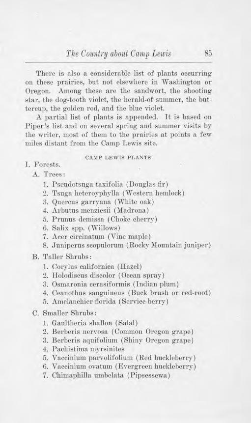
The Country about Camp Lewis 85
There is also a considel'able list of plants occuning on these pl'ail'ies, but not elsewhere in Washington Ol' Oregon. Among these are the sandwort, the shooting star, the clog-tooth violet, the herald-of-summer, the buttei·cup, the golden ro<l, and the blue Yiolet.
A partial list of plants is appended. It is based on Piper's list and on several spring antl summer visits by the writer, most of them to tbe prairies at points a few miles clistaut .from the Camp Lewis site.
CAMP LEWIS PLANTS I. Forests.
A. Trees: l. Pseudotsuga taxif olia (Douglas fir) 2. Tsuga heteroyph)·lla (Wes tern hemlock) 3. Quercus ganyana ('.Vhite oak) -!. Arbutus me1tziesii (Madrona) 5. Prunus <lemissa ( Choke cherry) 6. Salix spp. (Willows) 7. Acer circinatum (Vine maple) 8. Juniperus scopulorum (Rocky :MoU11tain junipel')
B. Taller Shrubs: 1. Oorylus cali.fornica (Hazel) 2. Holodiscus discolor ( Ocean spray) 3. Osmaronia cerasiformis (Indian plum) 4. Ceanothus sanguineus (Buck brush or reel-root) 5. Amelanchier flo1·ida (Service berry)
0. Smaller Shrubs : 1. Gaultheria shallon (Salal) 2. Berberis nervosa ( Common Oregon grape) 3. Berberis aquifolium (Shiny Oregon grape) 4. Pacbistjma myrsinitcs 5. Vaccinium parvolifolium (Red huckleberry) 6. Vaccinium ovatum (Evergreen huckleberry) 7. Olrimaphilla m11belata (Pipsessewa)
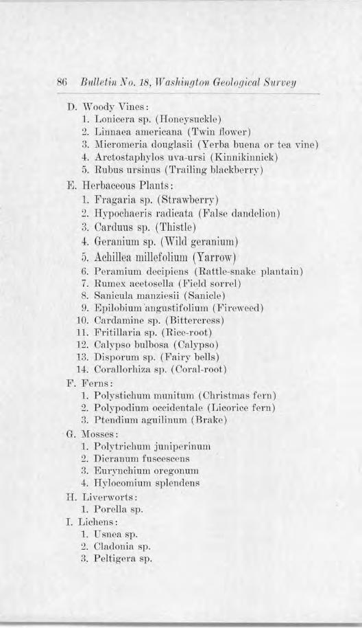
6 Bull pf in ~Vo. 18, W a.shiH.9lon Geolo.{J ical • 11 rivey
D. Woody Vjnes: 1. Lonicera sp. (Honeysuckle) 2. Liunaea americana (Twin f:lo'iver) 3. 1\rucrorneria doug]asii (Yerba buena or tea vine) 4. Arctostaphylos uva-ursi (Kinnikinnick) j, Rubus ursinus (Tra iling blackbcny)
E. Herbaceous Plants : 1. Fragaria sp. (StrawbeHy) 9 Hypochacri. ra<licata (Fahie dandelion) 3. Carduus sp. (Thistle) -t G-eraninm sp. (\Vild genmitun) 5. Achillea millefoliurn (Yarrow) G. P erarnium clccipicns (Rattle-snake plantain) 7. Rumcx acctosella Clt'iclcl son :cl)
anicnla man~icr.,ii ( anicle) 9. Epilobium ·angustifolium (Fircwced)
10. Cardamine sp. (Bittercress) 11 . Fritillaria sp. (Rice-root) 12. Calypso bulbosa (Calypso) 13. Disporum sp. (Fairr bells) 14. Corallorhiza SI). ( Coral-root)
F. Ferns: 1. Polystichum munitum (Cbri. tnia.· fem) 2. Polypoclium occidentalc (Licorice fern) 3. Ptendium aguHinum (Brake)
G. l\f osses: 1. Polytrichum junipcrinum 2. Dicrnnum f--uscescens 3. Eur~"llchi.um orcgouum 4. H-ylocomium splcndenR
II. LiYc rworts: l . Poi-clla sp.
I. Lichens: 1. Usnca sp. 2. Cladonia sp. 3. Peltigcra sp.
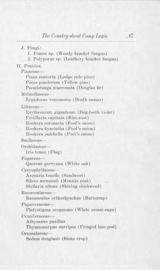
The Cowdry about Camp Lewis
J. F1mgi: l. Fornes sp. (W oocly bracket fungus) 2. Polyporus sp. (Leathery bracket fungus)
IL Prairies. Pilrnccae-
Pinus contorta (Lodge pole pine) Pums pornlcrosa (Yellow piue) Pscrnlotsuga mucr011a tri (Douglas f:ir)
hlclan thaceae-Zygaclcnus vcncruosns (Death camas)
Liliaceae-Erythronium gigantcum (Dog-tooth violet) Fritillaria capitata (Rice-root) Ilookcra coronaria (Fool's ouiou) Hookcra hyacintha (Fool's onion) Hookenl. pulcbelh1 (F'ool 's onion)
SmilaccaeOrcbi<laccae-
Iris ten ax (Flag) Fagaccne-
Quercus ganyrurn (Wlutc oak) Caryopbyllaceae-
Arenaria te11clln (Sandwort) Silcne menziesii (l\f enziis pink) Stellaria nitcns (Shining chickweed)
Ranuncnlaceae-Ranunculus orthorhynchus (Buttercup)
Papaver::tceae-Platystigma orcganum CWhite cream-cups)
Cruciferaceae-Athysanus pusillus Thrsanocarpus curvipes (Fringed lace-pod)
Orassalaceae-Sedum douglasii ( Stone crop)
87
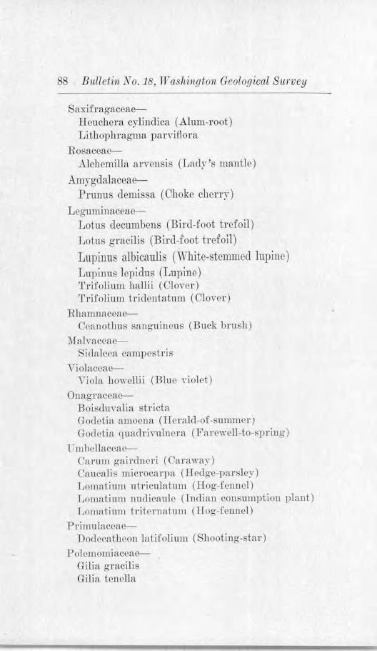
8 Bulletin i~o. 18, TY ashi11gton Geological Siirvey
Saxiiragaceae-Hcuchera cylindica (Alum-root) Lithophragroa parviAora
Rosaceae-Alchemilla arvcnsi (Lady's mantle)
ArnY"gdalaceae-Prun u. llerni. sa (Choke cherry)
Leguminaceae-Lotus decumbens (Bird-foot trefoil)
Lotus gracilis (Bi.rcl-£oot trefoil) Lupinus albicaulis (,Vbitc-stemmecl lupine) Lupin us lcpic1us (Lupjn c) Trifoliuru halli.i (Clover ) T rifolium tri<lenta tum ( Clo,rer)
Rhamnaceae-Ceanothus sang·uinous (Buck brush)
Malvaceae-Sida lcca campestris
Violaceae-Yiola howellii (Blue violet)
OnagraceaeBoiscluva lia stricta Gorlctia amocnH (Hcralcl-of-surnnwrj God et i a qua cl rintlncn\ ( Fa rcwcll-to-spring)
Ll1l1Jellaecac-Carurn ga i rclncri ( Carawa:,r) Caucalis rnicrocarpa (rfoclgc-pa rsler) Lornatinrn utriculatum (Hog-fennel ) Lomafa1m m1<licaule (Tnclian c011surnption plant) Lomatium triic>rnatum ( llog·-fcnucl)
Primu1aceae-Doclcc::itbeon latifolium ( hooting-star)
Polcmomiaceac-Gilia gracili s Gilia lenclla
ThP Couutry about Camp Lewis
Hydrophydaceae-Polcmomium micrautlrnm ( Greek valeria11)
Boraginaceae-P ectocarya pcuicillata
Scru phulari a cea e-Collinsia granclifiorn (Blue-lips) Orthocarpus attcnuatus (Owl cloYcr) S)-rrtthyris rotnudifolia Tonella collensioides
Valerianacea e-Val erianella congesta ( Common sa lal)
L obeliaceae-Githopsis specularioidcs Heterocodon rariflorum
Composi taceac-.Agoseris hetcrophylla ( Goat chicory) .Antennaria howellii (Everlasting) Balsamorhizn bookeri (Balsam root) Balsamorhizn deltoiclea Crociditm1 multicaule lDrigcron spcciosus (P1·ctty- fleahanc) Grimlelia integrifo1ia (Gnu-weed) Hemizonella durandi Hieracium scouleri (Ilawkweed) Psilocarphus elatior Scorzonella orcgmrn CWilcl cucumber) Seuecio fostigia Lus (Ragwort) Sericocarphus Tigidus (White-topped aster)
89
This account of Camp Lewis plants is not writ.ten for botanists. Those interested in these plants from the technical standpoint arc referred to i.hc following l1ooks:
l. Frye and Rig-g-X orthwcst Flora. ( Out of print, but copies may be consulted in public librarirs.)
2. Frye and Rigg-Elementary Flora of the Northwest. American Book CompaD>·
90 Bulletin No. 18, Washin.r;ton Geolo,r;ical Sw·vey
3. Frye and ,Jackson-The F erns of Washington. Uni,ersity Book tore, ni,e1·sity Station, Seattle.
4. Howell-The Flora of Northwest Ameri ca. (Report('cl to be out of print, hut copies mu~· be consulted in public libr-arios.)
5. Pipcr- Jl..,lora of ·washi11Pto11, Volume XI. Contributions from the United States K atioual Ilerbarium. ( Out of print, but copies may be consulted in public Ubrar ies.)
6. Piper and Beattie-Flom of the X orthwest Coast. ~ h1te College, Pullman, Washington.
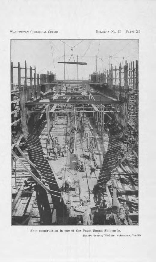
WASHJNGTON GEOLOGICAL Ht:RVP,\' liL'l,LUI~ KO. JS 1'!.AT!e X-l
/\f •
Ship construction in one of lbe Puget Sound Shipyards. - Bv <·<111rte8y of lVrbster .c- .<Hr' t>(·11.1. !,.-1,11/c
CHAPTER VIII
THE RELATI ON OF TB:E GEOLOGY OF 'WESTERN WASHINGTON TO ~IEASURE OF
:MILITARY DEFENSE
Duri11g the scores of years of peace, attention ,ms turned toward civil rather than milita1y questions. In consequence of this, general lmowledge of the relation of Washington's phrsical features to the plausible routes of invasion which au enemy would pursue, and of the conclitions which the topography along these routes afford for defense, is more or less vague. It seem appropriate, therefore, to call attention to these matte1·s and discuss in a general way the 1."Clation of the geological features of Washington to war strategy.
WESTERN WASHINGTON AS A PRIZE OF CONQUEST
If war were to be brought to the Yel"y door of the United States, western Washington would likely· face hostile attack, fo1· on the one hand it is the gateway to the Great Northwest, and on the other to Alaska, Siberia and the Orient. Eight transcontinental railways terminate in western WashiJ1gt011, four of them enterjng 0 11
their own lines and two by water. These, with oceangoing vessels, have developed a frade which in 1917 totaled more thru1 $376,000,000, making the Port of Puget
ound the s ixth i.n importance i11 the entire country. As has been mentioned hereinbefore, Puget ound is a harbor unsurpassed in the ,rorld. Its natural protection, its great depth of water, its connection at Seattle with a large fresh-·water harbor, the absence of shoaJs, the low cost of maintenance of the docks, the freedom of entrance of all vessels into the harbor under their own stean1 and pilot-all of these factol"S g ive it an enviable nrnk and insure it unlimited possibilities of trade in the future.
This alone would make the conquest of western Washington an important one. But there are fundamental 1·e-
The Cou11tr.t1 about Camp Lewis 93
sources to go ·with it. Perhaps the first of them is the mild climate which enables i11dustria·1 actfrity t.hc year round. Then thcl'e are the great forests. ,Yashingtou ranks first in the output of lumber, and oYcr 40 per ce11t of the public wealth of the sta to comes directly from this indusb-y. The g-reat bulk of the forests g r ows we ·t of the Cascades where the rainfall is adequate. (Plate IX ifi a scene in one of ·washlngton 's forl'sts.) About four hundred billion board feet is estimated now to remain uncut, with a Ya1uc iu excess of foul' buncked billions of dollars. Scientific reforestation "·ill makl', in time, thi~ means of resource endless.
Another resource haYing dfrcct relation to the climate and the topogl'aphy of this state is the water-power of the mountains. In official reports, it is estimated that there is an amount of cncrg_f ia ilil' strcmns of ,VaRhington equiYalent to -:1:,932,000 ho1·se-power, which is greater than the water-power of ,111~· other state iH the U uivn. rrhus far on]y about 500.000 horse-power haxe hccn <1eveloped. At a time when iudustrics an.1 c,d.eriug an epocl1 of accelerated acth·it~-, aud when the power will be increasingly electrical, the wntcr-pmver resources of this state haYe lJecome of immense Yaluc.
All of thcsP resources, together with others, such as the fisheries, agTicultnral lands, mineral tleposits, shipbuiltliug, aud 111,mnfachll'i ug, make "-esteru "\\'" ash i 11gto11 an nrea of wonclcrJul opportun ity, and a prize-capture For m1 enemy-riower.
PROBABILITY OF ATTACK ON PUGET SOUND
In a conquest of western ,Yasbingto11, the capture of the Puget Sound counb·y would be most vital to the C'llcm.v. Although the counlies adjoining Puget Souutl comprise onlr about one-fifth of the area of the state, ~-et ther c011tain 0110-lrnlf of the total population. H er e arc located SC'attie, the metropolis of the ~orthwest, with its
94: Bulletin No. 18, TV asliington Geological Survey
population of 348,639; Tacoma, 112,770; Bellingham, B2,985; Everett, 35,486; Olympia, 6,996; and many small urban towns.'* Seattle and Tacoma are the te1·mj11als of the transcontinental rniJroads and tho steamship lines, and also the centers of most of the shipbuilding plants (P late X) which are of such necessity to the nation at this time, and of the large lumber indusfry, flour mills, packing-houses, and other essential industries.
NATURAL DEFENSES OF WASHINGTON
Washington's mountain rang-es constitute two lines of natural defense. The first or most western line is the Olympics and the Willapa Hills, and the second line is the Cascade Range. In the case of the Olympics, they coDstitute a barrier of the first order for nearly 60 miles of coast-line. Rising to heights of 5,000 to 8,000 feet above sea-level with a most rugged surface, mantled with heavy snow-fall in winter, and fringed on the nol'th, west, and south with a nanow sand and gravel plain, co,,er ed by an :impenetrable forest that runs well up on the mountain slopes, these mountains effectually safeguard their part of the coast.
The Willapa Hills to the south of Grays Harbor and the Chehalis River Valley have only moderate qualificat io11 s in r egard to th~ir height, for they r ange from less than 1,000 to 3,000 feet h igh, but they have a ver)7 inegular surface and heavily timbered slopes which would greatly r etard an advancing aTmy. Indeed, little advantage ·would there be to the enemy to gain entrance to Willapa Harbor, even if he could, for ru1y further advauce would have to be made along the s ing-le highway which crosses the mountains, or alo11g the two Tailroad l ines. In an.v case the roadways are narro·w, and prominent hills of great defens ive value command them. .Al-
• These populallons were quoted from estimates of the Census Bur·eau, July 1, 1916, wllh the exce1>tlon of Olympia, whose population is based on the census retu1·ns of 1910.
Tlte Coimtry about Camp Le1vis 95
though not a barrier of the first order, ihc Willapa ITills could Ntsily be made impassable by a rclalin>]y sumll but well equipped arrnr. Tlieu ,4.5 Hdclitioual n1i]es of coast would be protected.
The Cascade :Mountains constitute the sccon<l li nc o.f defense for nll of the country to the east of U1<m1, nud a barrier to n flflnking attack of the Pugd Sound area, excevt br a long circuitous route through the Columbia Rivt•r Gorge, to intercept the railroad lines which suppl~., western Washington. Tbis possibility wilJ be considered a little later. Tllcre arc (fre passes wbicl1 might he used for tbe bringing of supplies from the east : Rtevens Pass, betwee11 the headwaters of the South Fork or the Rkykomish Ri,-e1· and XaR011 Creek, wl1icl1 lias nn clo,·ation of ..i.,061 feet above soa; S11oqualmie Pass, betw-0en the hearlwatcl'S of t11e Sontb Fol'k of tl1c Snoqualmie River anc1 the Yakima River, 3,010 feet; Stampede PasR, between the bcad,vaters of tl1c Green m1cl YaJcima Ri,~ers, 3,925 feet; Xaches Pass, between the headwaters of Clearwater Ri ver and the )fiddle Fork of Naches Ri,-cr, -1-,988 feet; and lhe Columbia River Pass which is cut clown necu-ly to sea-level. (These and other features involved in this discussion arc show11 on Plate IL ) Three of the transco11ti11ental railroads use three of the passes for crossing the mountains; the Great N orthcrn, Stevens Pass; t.he Chicago, Milwaukee & St. Poul, Rno(Jnalmie Pass; and the Northern Pacific, Stampede Pass. The Spokane, Portlaoc1 & Scatlle Railway and the OregonWasl1ington Railway a11Cl Navigation Compimy fol1ow the Columbia Ri,~er. One automohi1c higlnvay, the Sunset Highway, has been completed across thC' mountains at Sno('J1.uumje Pass, and this is improved nearly the e1J
tire distance from Seattle lo Ellensburg, with a maximum grade of five per cent. Another is nearly completed across Steve11s Pass on a maximum grade of about seven per cent, wl1 ich will connect with the Pacific Highwa~· at
96 Bulletin No. 181 Tr ashi11gto11 Geological Survey
E\7erett au<l the Sunset Highway at W enatchee. Thirtytwo miles of this road through Snohomish C0tmty is on concrete pm--rement. A third road, the .JfoOlellan P ass Highway, which will eventually cross and connect the Pacific Highway at Auburn -with the Inland l~mpire Highway at Yal{ima on a relatively low grade, lacks about 16 miles of being completed near the snmmit; elsewhere it is surfaced with gravel or crushed rock most of the di stance. Another road, partially completed, will in time be co11tinued up tlie western Banks of the mountains along
the North Fork of the Cowli tz River to Carlton Pass anu thence to the McClellan Pass Highway at the mouth of Bumping Ri-.,.er. A highway follows the north side of the Columbia River from Vancouver eastward to a few miles beyond Stevenson, a11d ends at the rock cliffs of the Columbia. When the gaps i11 this road hetwce11 SteYe11-son and l\faryhill are completed, connection by automobile may then be made, b~· way of Golclemlale, with the Inland Empire Highway west of Grau<lvie,,T, i11 Yakima Coun~~. The Columbia River Highway on the south sicle of the Columbia Rin:r extends from the western coast ol: Oregon into eastern Oregon and connects br fcrr~- with points across the 1·ivcr at The Dalles.
All of the highways across the mountains would he an aid to the railroads during a crisis, e);Cept <luri11g the winter, and then the higlrnra:,·s along the Columbia Ri,·cr would be of exceptional vc1luc. It ·woulc1 seem tlrnt all J)roposed higl1wa)-s crossing the mou11taii1s sboulcl he completed at the earliest possible date, for otherwise what has been partialJy built would he of little or no aYail. Dur:i.ug hea-vy snowslides or washouts in the mom1-tains1 the ·pokane, Portland & eattle Railwa~· and the Orcgon-·Washington Railwa:,· arnl 2\avigation Compan)· 's line through the Coluruhia Rivel' Gorge ·would he o,·ei·burdenecl with traffic.
The Couutry about Camv LPwis 97
STRATEGIC ROUTES OF ATTACK
If the enemy were to succeed in 0Yerpow01·ing our navy, the routes of invasion woul<l then be determined primarily b;v topographr. We have seen that the Olympic :Mountains are impassable an<l the ,Villapa Hills would be d ifficult for a large army to cross in the face of fire. It is obvious then that if there arc any li11 es that would offer Jess rosista11cc, they would likc-ly he attempted. Of these there are three: (1) The Strait ot Juan de FuN1 to AclmiralL)- lulet, the tnrnk passage to Pug-ct Souml; (:2) Grays Ilarbor and the Chehalis Valley; (;3) the Columhia River to tlte Cowlitz River Valley, thence 11orth acroRs tl1e low <.1i,icle al N"apaYine to the Pug<>t Round c01mtry. ('l'bese are indicated on Plate II.)
! I) TIIE :-;TUAI'!' O(•' ;TUAN DE; li'l."t:,\ .\1'D • .\.l)MILALTY l~Lli:T
J<'rom tltc open ocean to the bcginn i11g- oJ Aclmi ralty fol<'t is H clistnncc of ne:-nlr 90 miles; from Port To"\\'11-scnd, which conunamls lhe bead of Admira1t:,· Inlet, lt)
Seattle ah011t JO miles; urnl to 'rncorna about JS miles farth01·. 'l'he Strait bas a witlth of' 12 to 15 miles, the passage nt Port Towm,end abouL four miles, aucl thC' Inh•t on the ciu;t siclc of hlnury Island two milN;.
.Most or these waters arc deep. At tJ1e mouU, of the Strait tlicr arc about 900 feet deep, and in going eastward U1cy gradually shallow until at the passag-e cast of Port Tow1.1Rcnd they arc about 240 f'cet i11 depth. Froru here south, along Aclmiralt:,- Inlet, they cease shallowiug and for practicall? the whole distance to Tacoma they cxcC'ed n depth of 300 feet. Indeecl, off Pt. J efferson, ther rcacli a depth of a little o,er 000 feet, and at lhc entrance to RC'attlc 's harbor, nearly 600 feet.
Of' cou rsc, without preYiously preparC'd d<.'fens<'s of modern artillery, minC's, arnl fighting Rhips. this woulcl be the qi1ickC'st way to captm·<' the whole Puget Soull(l com1try. This in itself would inYitc a surprise attack
- ~
•
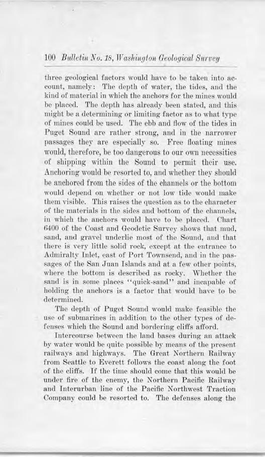
100 Bulletin No. 18, Waslti11gton Geological Stirvey
throe geological factors would have to ho taken into acco1int, namely: The depth of water, the tides, and the kind of material in which the anchors fo1· the mines would be placed. The depth has already been tated, and this might be a determining- or l imiting factor as to what type of mines could be used. The ebb and fiow of the tides in Pug-et Sound are rather strong, and in the nanower passages they are e pecially so. Free floating mines would, therefore, be too dangerous to our own necessities of shipping within the Sound to permit their use. Anchoring would be resorted to, and whether ther should be anchored from tho sides of the channels or the bottom would depend on whether or not low tide would make ihem visible. This raises the question as to the character of the materials iu the sides and hottom of the chaimels, in which the anchors would have to be placed. Chart MOO of the Coast and Oeocletic Survey shows that mud, sand, ancl gravel underlie most of the Sound, an<l that tl1crc js Yer~ little solid rock, except at the enhance to Admiralty Inlet, cast of Port Townsend, and in the pasS~lgcs of the San Juan Islands mid at a few other points, whore the bottom is describeu as rocky. "\Vhcther the sand is in some places "quick-sand" and incapable of holding the anchors is a factor that would lrnYe to he det0rmined.
The depth of Pug·et Sound would make feasible the use of submarines in addition to the other t~'pcs of defenses which the ound and bordering· cliffs afford.
Tutercourse between the land bases during an attack by water would be quite possible by means of the prese11t railways and highways. The Great Northern Railway from Seattle to Everett follows the coast along the foot of the cliffs. If the time should come that this ·would be under fire of the enemy, the NoTthern P acific Railway and Interlll'ban line of the Pacific },.T orthwcst Traction Company could be resorted to. The defenses along the
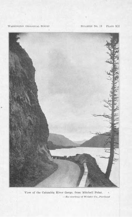
•
WASHlKGTOX GEOI..OCICAL SORVE\" BULU:1'IN No. 18 PLAT!,; Xll
View of the Columhia River Gorge. from Mitchell Point. -By rr,11rtt·s.111,J W rfster Co. , Pol'l//rnd
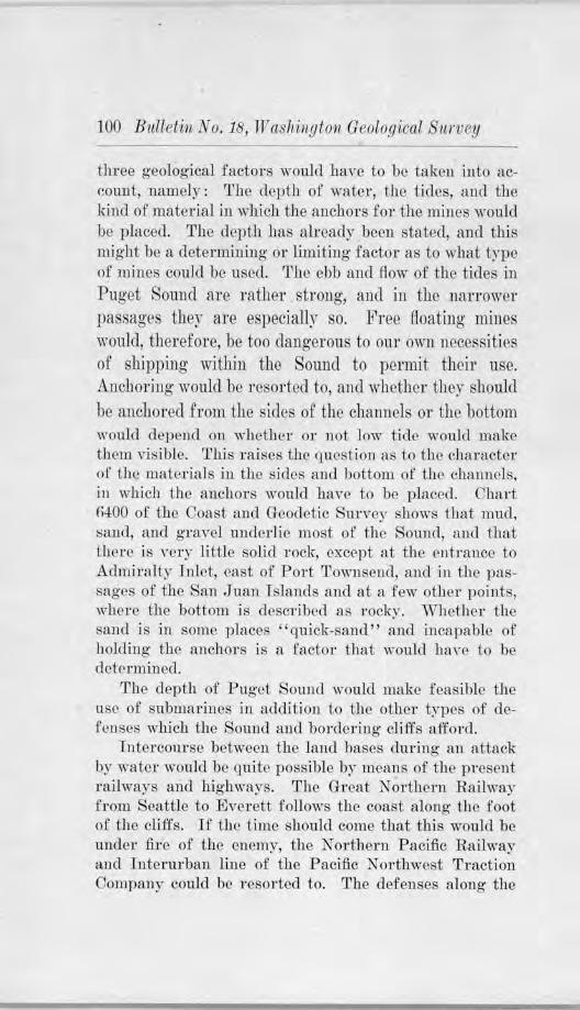
J 00 Bull eti11 No. 18, TV ashington Geological Snrvey
three geological factors would have to be taken into account, namely: The depth of water, the tides, and the ki11d of material in which the anchors for the mines would be }Jlaced. The depth has already been stated, and this might be a determining or limiting factor as to what type of mines could be used. The ebb and flow of the tides in Puget Sound are rather strong, and in the narrower 11assRges they are especiall)" so. Free (foating- mines would, therefore, be too dangerous to our own necessities of shipping within tho Sound to pel'mit their use. Anchoring- would be resorted to, and ·whether they should be anchored from the sides of the channels or the bottom would depend on whether or not low tide ·would make them visible. This raises the question as to the character of the materjals in the sides and hottom of the channels, in which the anchors would have to be placed. Chart fi400 of the Coast and Geodetic S-lll'vey shows that mud, sand, and gravel underlie most of the S0tu1d, ancl that there is very little solid rock, except at the 011trance to Admiralty I nlet, east of Port T°'\11send, and in the passages of the Sa11 Juan I slan<ls and at a few other points, where the bottom is clcsm·ihed as rocky. Whether the s1rnd js in some places "quick-sand" and incapable of holdi11g the anchors is a factot that ·would ha ,·c to be dctermi11ed.
The depth of Puget S0w1cl would make feasible the L1se of submarines in addition to the other types of defeuses ·which the oun<l and bordering cliffs afford.
foterco1U'se between the laud bases during au attack br water would be quite possible by means of the present railways and highways. The Great Northern Railway from Seattle to Everett follows the coast along the foot of the cliffs. If the time should come that this would be under fhe of the enemy, the Northern Pacific Railway and Interlll'ban line of the Pacific N ortlnvest Traction Company could be resorted to. The defenses along the
11he Country about Camp Lewis 101
south side of the Strait of Juan de Fuca would have to be suppliecl hy boats, chiefly, and supplemented by the Olympic Highway from Olympia to Port Towuseud, which has been graded and surfaced for the greater part of the distance.
Climatic Factors
Ce1-ta in climatic factors might have an important part in the <l<>feat or success of the enemy's naval forces. This is also frue of any land operations that won1d take place. The climate of ,,,cstcrn Washiugton aiid tbe causes for it have heen discusse<l i11 Chapter T, but we will recall here onlr the points of y-ital importance to our topic. The ~ear is divided into a " 'et and a dry season. The wet season comes in winter antl the d,y season in summer. Gc11erall~ during the summer the skies are clear, and cloudy <la~~s arc few. Tn winter, clear clays arc the exception. Beginning in October, the mornings are foggr, and thr fogs gracluallr hecome bcayier, morning after morning, until the rnins begin. These fog-s would aicl in giving cover to an ell(m1r in a surprise attack. Fogs arc f <1 irly prominent in the spring·, hut not so much 1-1s in lhe fall. Snowsto:rms ·would also give aid to the enemy, but the~· a re so ruicommon and uudepcndahle as to gh·e I ittlc concern.
During- the clouclr cJa~,s of wi11tcr1 airship pah-ol would he more or less haudicn.ppcd. This would perhaps be a g-reater disaclnrntagc to the enemy than to our forces, . for his observations nccessaTily would lrnve to be over a larger and less familiar area than ours.
On land, the strength of the roads to withstand heavy haffic would a1so be much less in winter than in summer, because of the frequent rains. :H'loods arc nlso mor<.' frequent and bridges are more likely to be m1safo or destroyed. The wide bottom lands of the Purallup Valley, Duwamish Valley, Snohomish Valley, StiJaguamish Yalley, and the La Conner Flats of the Skag·it River are
102 B11lletill No . . 18, Washington Geological Survey
sometimes completely inundated, and transportation is cnt off for days at a time. If this were to happen during an attack on Puget Sound it would be a ,-rei-y serious matter and the construction of pontoon bridges would have to he resorted to.
(2) THE: GRAYS HA.HBO.ft A.XU CHEHALTS \"ALLEY GA'fEW AY
This gateway lies betwen the Olympic on the north and the Willapa Hill on t11e outh. Gray Harbor owes its east-west elongation to the fact that a loweri11g of the land area during pre-historic times permitted the seawater to enter the lower portion of the Chehalis River Valley as far eastward as the present site of Abcl'cleen. The bars or spits at the entrance arc composed of sand which has been brougllt by shore currents and th1·0,,rn up by the waves. These provide a protection to the harbor dur ing severe ocean storms, but the constant shifting of the material by the shore cmrents threatened some years ago to close the harbor. To prevent this jetties were built. Silt, sand, and grnvel, brought down by the Chehalis R.iYer, has also tended to make the ha1·bo1· shallow. so that frequent dredging is necessary to keep a channel open for large ships. In some places this channel is but 20 feet deep and comparatively narrow, and elsewhere the sand and mud bars come nearly to the water's level.
With such a situation, Hoquiam, situated 12 miles from the entrance, and Aberdeen, four miles fal'iher, are much safer an<l more easily protected than if the harbor were deep enough to give the invading fleet free play. Added to these difficulties is the fact that several miles of low swampy land, C0"\7 ered with .forests, intel'vene between the western coast and the hill r egion to the east, both on the north and south sides of the entrance. This ·would handicap the landing and use of t roops. A railroad r ight-of-way on the north side from Moclips to the har bor and a r ailroad and highway on the sou th side would aid in defense.
Tlte Cow1/ ry about Camp Lticis 103
Beginning at a point ahont ti\'c miles west or Hoquiam, n cliff escarpmcu t ove1·looks ilie water's edge and conti nucs up the valley of the Ohclrnlis Rivcff on both sides, except where broken by trilmtary valle)'S. )fany points along the way rise 300 feet and higher above the valley flat and the railroads an<l highways below1 thus giving a cowumudiug vositio11 over auy s ituatiou iu the valley. ~fost of these hills axe wooded. It is fa·ue that the \Yiclth of llio ,·alley, ubout lwo miles, would be somewhat iu the enemy's fa,·01·, but on the other hand its marshy charac.tcr and the absence of roads except along the foot of the bluffs would seem to react lo anr adnmfagc that the width of the valley might give.
At Elma, a<lmitiing that Urn enemy thus far might have overcome resistance, he would have to choose bchveen lwo possibilities: (]) to proceed J)Ortheast OVC'r the low sm11mit north or the Blnck Hills toward OlympiR, Can11> Lewis c1nd 'raconw, or (2) to eo11tinuc ,tl<mg thC' (lbolw lis Ri,~e1· to Gai0 or Hnrnc111found, arnl lhC'TIC'!' north tow:nd Olympia nncl north<'ast toward Camp Lewis and 'racoma. (See Plate 11.) The> fh·i-t has the adnrnlcig-c of tlw shortrr c1istmicc nnd of' the Olrmpic 1:Tiglnrny. hut a c011siclcn1ble part of the dist..tnct· is th roug·h limher. 'J.11w ~cc•oncl has the advantagC' of a wider valley an<l a more• opr11 country herond Gait'. But 110th wou]d he at the clisadv,mtagc of tl1e stn1.tegic positions of dcfcuse offerC'd by the Black llills which ]ic between Hnd which rise to an elevation of 1,000 to 1,500 feet above soa-lM·cl.
The <listance from AberclN•ll, the most eastern point of Gra~·s Ha1·hor1 to Ol~·mpia, b., wa>' of tlie shorter route, is 55 miles. Camp Lewis ]ies abou1 17 milN.; farthrr. An C'DC'lll)' would hnrdl>· he attaining irny of bis ultimate aims until he cou]d rearh a point ·within str iking- distance of Camp Lcrn·is.
At all <.',~ents, il is clear that the topograp11~· alo11g 1.b0 Gravs Harbor antl Chehalis Ri,~cr route offers manz . . excellent posit.ions for successful clefcnse.
104 Bulletin No. 18, nr ashington Geological Survey
(3) TRE COLUMBIA RIVER-COWLITZ V ALl:,EY ROUTE
From the mouth of Columbia River to the Cowlitz Valley is about 65 miles; from the mouth of Cowlitz River to Olympia by air-line is another 65 miles.
The Columbia R iver is broad fol' some distance above its mouth, due to the same subsidence of the land area which made Grays Harbor. For 20 to 25 miles its width range from 4 to 10 or J 2 mile , and for the remainder of the distance to the Cowlitz River its width averages one mile or more. The upland on either side is high and breaks with many precipitous bluffs to the riTer below, thcreb:v proyicling excellent natural position for defense.
The valley of the Cowlitz RiYer is 1·elatively narrow and crooked. The raihoad and the Pacific Highway hug the base of the east valley-wall most of the way. Any :ittcmpte<l invasion along this line would he in the face of a terrific resistance, ii Lhe admirably situated bluffs were at all adequately equipped with batteries.
No highway runs continuously from the Cowlifa River to the coast. The tra11sportation of troops along the Columbia would lrnYe Lo he either by water or along the railroad line or the Columbia Highway 011 tbc south side, taki11g cha11ces on crossing b)r building a long pontoon bridge, if possible, or by boats, orb)' both. There is no brido-e short of Vancouver, 25 miles to the soulh. Tn either case such crossing would likely be umlcr the frre of our forces from the commanding bluffs.
This r oute of invasion obviously would present many disadvantages which probctbly exceed tl1ose of the Gra~·s H..irhor and Chehali s Valley.
COLUMBIA .RfVER. THROPGH 1'Hl~ CASCAOlll !JORGE, TO TEE COLUMBJA PL..ATEAU
Ali invasion along the 1olumbi.a River, passil1g eastward ihrough the goro·e of the Cascade 1Iouutains to the Columbia Plateau, ancl intercepting the transc01Jtine11tal railways which supply the P uget Sound Basin, is a
The Cou11try about Camp Lewis 105
strategic moYe that might -possibly- be attempted. The distance, however, is great. From the month of the Columbia to the nearest 11oint of interception at Pasco is about 400 miles, but a further traverse of a hundred miles or more would be necessary to complete the capture of all of the railroads. The total would seem prohibitive. In addition to the problem of distance would be the difficulty of passing through the Columbia Gorge. A short distance east of Vancouver arc the foothills of the Cascades. These pass mpidly i11to relief of motmtainous proportions, and both walls of the Columbia, high and pro;jcctiug, are wonderfully adapted to military defense. (Plate IX.) IJ any route can be made impassable hy modem batteries, this one uucloubtecUy could be.
After considering these geographical an<l geolog-ical conditions, it would seem that we possess the first essentials for blocking an inYasion by this route.
SUM).(ARY AND GEr,{ERAL CONCLUSION
The presence of the Olympjc :Mountains aud the Willapa Ilills aloug the western coast sene as natural harriers iu guarding the greater part of the coast-line. They leave but three plausible entrances for invasion, nud these arc of such a topographical character t]rnt they <'an easily- he turned into fu1es of nclccinate dcf ense. The existence of the Cascade Range to the east of the Puget Sound country would pre-vent a flank attack, except by a long forbidding circuitous route through the Columbia Gorge.
·with such a topography, so fldmirably adapted for defense against hostile invasion, it would seem that the rest of the question of a successful resistance would lie with the Government.
-5
P C7"J-{ LIC.A.'J· I O~ S OF 'l'HF.
WAJ'H1NC:'l 'OX GEOJ,00 IUA L TRYEY
Al)DL~ESS
S T .ATE LlB R AHlA ~
(ll,Y31PIA. WASl·II X(l'l'OX
Volume I .-Annual Report for 1901. Part 1, Creation of the State Geological Survey, and An Outline of the Geology of Washington, by Henry Landes; part 2, The Metalliferous Resources of Washington, Except Iron. by Henry Landes. William S. Thyng, D. A. Lyon and Milnor Roberts; part 3, The Non-MetallHerous Resources of Washington, Except Coal, by Henry Landes; part 4, The Iron Ores of Washington. by S. Shedd. and the Coal Deposits of Washington. by Henry Landes; part 5, The Water Resources of \Vashington, by H. G. Byers. C. A. Ruddy and R. ID. Heine; 1,arL 6. Bibliography of Lhe LiLerature Rererring to the Geology or Washington, by Ralph Arnold. Out or print.
Y <>lwne 2 .-An.nual Report for 1902. Pal'l l, The Building a:ncl Ornamental Stones of Washington. by S. Slledd; part 2. The Coal Deposits Of Washington. by Henry Landes and C. A. Rudely. Out of print.
Bulletin 1.-Geology and Ore Deposits of Republic Mining District. by .Joseph B. Umpleby. Bound in cloth; price 35 cents.
lloJletin 2.- The Road Materials of Washington, by Henry Landes. Bound in cloth; tlrice. GO cents.
BuUetin !l.- Tl1e Coal Fields of King County. by Geo. W. Evans. Bound in cloth; price, 75 cents.
nu.1Jeti11 4.-The Cement Materiali; of WashingLon. by S. Shedd. Bound In cloth: price. 75 cents. Paper cover; price, 4 O cents.
Bulletin 5.- Geology and Ore Deposits of the Myers Creek and Oroville-Nighthawk Districts, by Joseph B. Umpleby. Bound iu cloth: tlrice. 1)0 cents.
Bulletin 6.- 0eology and Ore Deposits or tile Blewett Mining District, by Charles E. Weaver. Bound in cloth: price 60 cents.
Hullelln ',.- Geology and Ore Deposits or the Illdex Mining District. by Charles E. ,lveaver. Bound in cloth: price, 50 cents.
B uIJetin 8.- Glaciation of the Puget Sound Region. by J. Harlan Bretz. Bound in cloth; price, 60 cents. Paper cover; price. 35 cents.
Bulletin 0.- The Coal Fields of Kittitas Coun ty, h)' m. J. Saunders. Paper cover: price. 4 0 cents.
Uullctiu 10.- The Coal Fields of Pierce County. br Joseph Daniels. Bound in cloth; price, 60 cents. Paper cover, price. 40 cents.
Bul letin 11.-The l\fiueral Resources or Washington. with Statistics for 1912, by Heury Landes. Paper cover: price. 25 cents.
H1tlletin 12.- Bibliography or Washington Geology and Geography, by Gretchen O'D011neU. Paper cover; price, 25 cents.
BuJle lin 1a.- The 'l'erliary Formations or Western Washington. hy Charles E. Weaver. Paper cover ; price, 40 cents.
BuHetin t4.-The Quincy Yalley Irrigation Project, by Henry Landes, A. W. Mangum, H. K. Denson, E. J. Saunders, and Joseph Jacobs. Paper cover; prlce, 20 cents. Out of print.
IluJJeti11 1:S.-A Preliminary Re1>ort on lhe Tertiary Paleontology of Western Washington. by Chas. EJ. Weaver. Paper cover; J>rice, 2 0 cents.
Bnllel in 16.-Geology and Ore Deposit!I of Lhe Covada Mining District, by Cl1arles .HJ. Weaver. Paper cover; price. 26 cents.
BuJJetiu li.-A Geographic Dictionary of Washington, by Hem·y Landes. Paper cover; price. 7!i cents.
HuJletin 18.- The Country about Camp Lewis, by Morris J\!. Lelghtou. Paper cover; price, 50 cents.
Bulle tin H).- The Coal Fields or South western Washington. by Harold Culver. Paper cover; price. 75 cents. In preparation.
Bulle tin 20.-The ~lineraJ Resources of Stevens County, by Charles E. ,veaver. Paper cover; price. one dollar. In J)reparation.
Bulle Ch1 21.- The Mineral Resources of Washington, with Statistics for L917, hy Henry Landes. Paper cover; prlce. 50 cents. In 11reparation.
Bulletin 22.-The Sand and Gravel Deposits of Washington Suitable for Road Building, by Morris M. Leighton. Paper cover; price. 7n cents. tn preparation.
Pc;BLIC'ATIONS OF THE U. S. GEOLOGICAL SUR\'EY, TN COOPERATION WITH TUE W ASHlNGTON
GEOLOGICAL SURYEY.
( For copies of these pubUcations address the Director, U. s. Geological Survey, Washington. D. C. Waler-Supply 11apers may also he obtained. upon request. from the U. S. Geological Survey district office. 406 i;'ederal BuiJding, Tacoma ,vashington.
•r opog ,·aphk ;\hips or the '1'ollowi11g Qnadnmgles.
Arlington, Beverly, Cedar Lake. Chehalls. Connell, Coyote Rapids, Hoquiam, 11alaga, 1loses l,ake, Mount Vernon. Ocosta. Pasco. Priest Rapids. Prosser, Quincy, Red Rock. Walla Walla. Wallula. Wenatchee, Winchester. (Samish Lake, ,anzandL and "Wickersham. in preparation.)
Powe,· Reports. ,vater-SuppJy Pa1,er No. 2!i 3: Waler Powers oC the Cascade
Range, Part J. Southem Washington. Water-Supply PaJ)er No. 313: Water Powers or Lile Cascade
Range. Part II. Southwestern Washington. Puget Sound Region. \·Vater-Supply Paper No. 31l!J: Water Powers of lhe Cascade
Range. Part Ill. Yakima Basin. Water-Supply Paper No. --: Water Powers oC lhe Cascade
Iltrnge, Part TY, ,venalchee and hlntiat basins. In preparation.
tlh-er Pmfiles.
Watel'-Supply Paper No. 346: Profile Surveys of Clark Fork of Columbia River.
Water-Supply Pa11er No. 3 66; Profile Surveys or Snoqualmie. Sultan. and Skykomish rivers.
Water-Supply Pa))er No. 368: Profile S1Lrveys or Wenatchee Ril·er and lrlbutaries.
Water-Supply Paper No. 376: Profile Surveys, Chelan and )fothow basins.
Water-Supply Paper No. 377: Profile Surveys, Spokane and John Day basins.
Water-Supply Paper No. 419: Profile Surveys in Skagit River Basin.
Annual Str·ea111-J"low R epOt'ls.
Water-Supply Paper No. 272: Surface Water Supply of the United Stales, North Pacific Coast, 1909.
Water-Supply Paper No. 292: Surface Water Supply of the United States, North Pacific Coast. 1910.
Water-Supply Paper No. 312: Surface Water Supply of the United States, North Pacific Coast, 1911.
Water·SUllPlY Paper No. 332: Sur face Water Supply of the United States, North Pacific Coast. 1912.
Water-Supply Paper No. 340. Gaging stations and publications on water resources 1885-1913.
Water-Supply Paper No. 362: Sur face Water Supply of the United States, North Pacific C'oast, 1913.
Water-Supply Papers Nos. 392. 393 and 394: Surface Water Supply of the Onited States. North Pacific Coast, 1914 .
Water-Suppl~· Papers os. 412. 413 and 414: Surface Waler Supl)IY of the United States, North Pacific Coast. 1915.
Water-Supply Papers Nos. 442. 443 and 444: Su r face Water Supply of the United St.ates. North Pacific Coast. 1916. Government Printing Office.
Water-Supply Papers Nos. 462, 463 and 464: Surface Water Supply or tbe United States, Nortb Pacific Coast, 1917. In preparation.
Qualitath"e Report .
(Principally in cooperation with State Board of liealtll. )
Water-Supply Paper No. 339: Quality of Surface VVaters of ·washington.
PUBLICATIONS OF THE U. S. DEPARTMENT OF AGRICULTURE. BUREAU OF SOILS, IN CO-OPERATION WITH THEJ
WASHINGTON GEOLOGICAL SURYEY.
(For copies of these publications address one oi tl1e members or congress from Washington.)
Reconnoissance Soil Survey of the Eastern Part of Puget Sound Basin.
Reconnoissance Soll Survey or the Western and Southern Parts of the Puget Sound Basin.
tion.
R econnaissance Soil Sur vey of Southwestern Washington . Reconnoissance Soil Survey or lhe Quincy Area. Reconnaissance Soil Survey of Stevens County. Reconuoissance Soil Survey of Franklin County. R econnoissance Soil Survey of Spokane County. In prepara-