Embed Size (px)
Citation preview
ATA Environmental ___________________________________________________________________________________
TABLE OF CONTENTS
1. INTRODUCTION.................................................................................................................... 1
1.1 Background ......................................................................................................................... 1 1.2 Purpose and Scope .............................................................................................................. 1 1.3 Climate ................................................................................................................................ 2 1.4 Topography ......................................................................................................................... 2 1.5 Geology and Soils ............................................................................................................... 3 1.6 Surface and Groundwater.................................................................................................... 3 1.7 Native Terrestrial Vegetation.............................................................................................. 3
2. METHODOLOGY................................................................................................................... 9
2.1 Database Searches............................................................................................................... 9 2.2 Regional Data.................................................................................................................... 10 2.3 Trapping............................................................................................................................ 11 2.4 Avifauna Surveys.............................................................................................................. 12 2.5 Spot-lighting Survey ......................................................................................................... 12 2.6 Bat Surveys and Non-Systematic Searches....................................................................... 13 2.7 Local Knowledge .............................................................................................................. 13 2.8 Survey Staff ...................................................................................................................... 13 2.9 Vouchering Specimens ..................................................................................................... 14 2.10 Limitations ........................................................................................................................ 14
3. RESULTS .............................................................................................................................. 18
3.1 Overall............................................................................................................................... 18 3.2 Nocturnal Searches ........................................................................................................... 18 3.3 Avifauna............................................................................................................................ 18 3.4 Reptiles ............................................................................................................................. 18 3.5 Mammals........................................................................................................................... 19 3.6 Amphibians ....................................................................................................................... 19 3.7 Fauna Assemblage Similarity ........................................................................................... 21 3.8 Fauna Assemblage Diversity ............................................................................................ 22 3.9 Species Potentially Occurring Within the Study Area Identified as Being of National
Environmental Significance under the EPBC Act 1999.................................................... 22 3.10 Significant Fauna under the WA Wildlife Conservation Act 1950-1979 ........................... 23 3.11 Likelihood of Significant Fauna Occurring in the Study Area ......................................... 25 3.12 Western Ringtail Possum Survey...................................................................................... 29 3.13 Western Ringtail Possum Dreys........................................................................................ 29 3.14 Numbers of Western Ringtail Possums............................................................................. 32 3.15 Introduced and Feral Animals........................................................................................... 32
4. DISCUSSION ........................................................................................................................ 33
4.1 Survey Adequacy .............................................................................................................. 33 4.1.1 Species Accumulation Curves ................................................................................ 33 4.1.2 Trap Type Bias ....................................................................................................... 33
4.2 Faunal Assemblage Comparisons with Other Studies ...................................................... 33 4.2.1 Avifauna ................................................................................................................. 33 4.2.2 Herpetofauna........................................................................................................... 33 4.2.3 Mammals ................................................................................................................ 33
4.3 Discussion of Western Ringtail Possums.......................................................................... 34 4.4 Assemblages with Ecological Significance ...................................................................... 35 4.5 Biodiversity Value ............................................................................................................ 36
5. SUMMARY AND CONCLUSION....................................................................................... 37
_____________________________________________________________________________ CRP-2003-001-0FAU_005_st_V4: Vertebrate Fauna Assessment - Smiths Beach, Yallingup i Version 4: 30 March 2007
ATA Environmental ___________________________________________________________________________________
REFERENCES................................................................................................................................. 39
LIST OF TABLES 1. Number of Trap Nights Per Trapping Study area Conducted at Smiths Beach 2. Fauna Survey Limitations and Constraints 3. Number of Individuals Caught in the Trapping Areas 4. Number of Individuals Caught in Various Trap-Types 5. Morisita-Horn Similarity Index Scores for the Reptile Assemblages Among the Five
Trapping Study areas 6. Diversity Index Scores for the Reptile Assemblages Among the Five Trapping Study
areas 7. Species Listed as Being Significant Vertebrate Fauna by the Commonwealth or State
Governments and Predicted to Occur in the Study Area 8. Drey and Hollow Locations and Descriptive Comments for Dreys Found on Sussex
Location 413 9. Drey and Hollow Locations and Descriptive Comments for Dreys Found Adjacent to
Sussex Location 413 10. Comparison of Trap Type and Intensity of Surveys Undertaken in Region
LIST OF FIGURES 1. Regional Location 2. Vegetation Associations 3. Location of Fauna Trapping Sites 4. Location of Western Ringtail Possums, Dreys, Brushtail Possums and Fox Holes
LIST OF PLATES 1. Banksia attenuata Woodland with occasional Marri (Corymbia calophylla) 2. Open Coastal Heath containing Allocasuarina humilis, Melaleuca. acerosa and Oleana
axillaris 3 Peppermint (Agonis flexuosa) / Eucalypt (Corymbia calophylla and occasional
Eucalyptus marginata) Woodland 4 Closed Coastal Scrub containing Acacia divergens, Melaleuca huegeli and Dryandra
sessilis _____________________________________________________________________________ CRP-2003-001-0FAU_005_st_V4: Vertebrate Fauna Assessment - Smiths Beach, Yallingup ii Version 4: 30 March 2007
ATA Environmental ___________________________________________________________________________________
5 Closed Coastal Heath Containing Pimelea ferruginea, Scaevola crassifolia, Acacia. divergens and Spyridium globulosum
6. Average Species Accumulation Curve for all Trapped Fauna 7. Average Species Accumulation Curve for Trapped Fauna at Study area 2 8. Species Accumulation Curve For Trapped Fauna By Ecologia Environmental
Consultants In April 2001
LIST OF APPENDICES 1. Details of Vouchered Specimens for Western Australian Museum 2. Species Caught, Recorded and Potentially Occurring within the Project Area
_____________________________________________________________________________ CRP-2003-001-0FAU_005_st_V4: Vertebrate Fauna Assessment - Smiths Beach, Yallingup iii Version 4: 30 March 2007
ATA Environmental _____________________________________________________________________
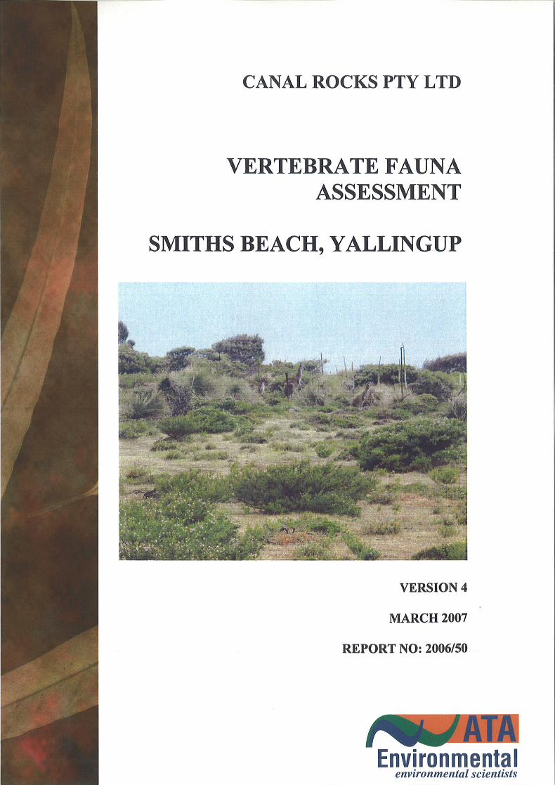
1. INTRODUCTION 1.1 Background Canal Rocks Pty Ltd is planning to develop part of Sussex Location 413 in the Shire of Busselton for tourist and residential purposes. Sussex Location 413 comprises approximately 40ha and is located adjacent to Smiths Beach (Figure 1). The proposed development comprises 25.1ha on the eastern two-thirds of Location 413 (the study area). The remainder of the study area will remain undeveloped. Sussex Location 413 is located at Smiths Beach between Yallingup and Canal Rocks on the south-west coast of Western Australia (Figure 1). The study area is situated within the Shire of Busselton. The eastern portion of the study area is zoned ‘Tourist and Additional Use – Residential’ under the Shire's District Town Planning Scheme (DTPS) No. 20 with the western third zoned ‘Recreation Reserve’ under DTPS No. 20. Immediately adjacent on the north-eastern side of the study area is the former Smiths Beach caravan park which is currently being redeveloped for chalet accommodation. To the south, and upslope of the study area is part of the Leeuwin-Naturaliste National Park that incorporates Canal Rocks. The National Park also includes land to the north-east of the study area including Smiths Beach and the Torpedo Rocks scenic lookout. To the immediate east is a tourist development (Chandler’s Chalets) and cleared rural land. Additional rural land backs the National Park further to the south. A Draft Development Guide Plan (DGP) has been prepared for the proposed development of a limited portion of Sussex Location 413. This document is currently in the process of review with the Shire of Busselton to resolve a range of issues. The Draft DGP will be advertised for public comment following successful resolution of these issues (Canal Rocks Pty Ltd 2005). Management recommendations and conclusions made in this report are based on the degree of habitat disturbance and modification necessary to develop that portion of the study area that is proposed to be developed as described in the Draft DGP document. 1.2 Purpose and Scope ATA Environmental was commissioned by Canal Rocks Pty Ltd to undertake a Level 2 vertebrate fauna assessment and to make recommendations on fauna related issues that should be addressed during the development of this study area. The fauna survey was undertaken in accordance with the Environmental Protection Authority (EPA) Position Statement No. 3 Terrestrial Biological Surveys as an Element of Biodiversity Protection (EPA, 2002) and Guidance for Assessment of Environmental Factors: Terrestrial Fauna Surveys for Environmental Impact Assessment in Western Australia, No. 56 (EPA, 2004). These Statements require a Level 2 fauna assessment for developments with impacts that are assessed as either ‘moderate’ or ‘high’ in the bioregion of the proposed project area. A Level 2 assessment involves undertaking either a detailed or comprehensive on-site fauna survey in addition to a desktop study. Environmental variables that contribute to ‘moderate’ or ‘high’ impacts are the size of the area (e.g. 1ha-10ha is moderate, and > 10ha is high), potential for rare or range restricted fauna in the area, whether the area contains habitat of ecological or conservation significance, whether the area serves as an ecological refuge for fauna species or the area supports populations of statutory protected species (e.g. those listed under JAMBA/CAMBA treaties). On this basis, the EPA Guidance Statement No. 56 required a Level 2 assessment be undertaken.
_____________________________________________________________________________ CRP-2003-001-0FAU_005_st_V4: Vertebrate Fauna Assessment - Smiths Beach, Yallingup 1 Version 4: 30 March 2007
ATA Environmental _____________________________________________________________________
This Level 2 fauna assessment was designed to supplement work completed in autumn 2001 by ecologia Environmental Consultants and to provide information regarding temporal variations in faunal assemblages in the region. This report includes: • a review of the Western Australian Museum on-line database (FaunaBase) to identify
potential vertebrate fauna in the area; a search of the Department of Environment and Conservation (previously Department of Conservation and Land Management’s) Threatened and Priority Species database to identify potential scheduled and threatened species in the region; • a search of the Commonwealth’s on-line database to identify fauna species of national
environmental significance that are protected under the Environment Protection and Biodiversity Conservation Act 1999 potentially occurring in the area;
• a review of the published and unpublished literature that ATA Environmental could
access to provide a list of fauna that have potential to occur in the region; • discussion on the potential impacts of the development on the fauna and fauna habitat;
and • management recommendations to minimise the potential impacts on the fauna. 1.3 Climate The Leeuwin Naturaliste coast experiences a Mediterranean climate with warm to hot, dry summers and mild, wet winters. High-pressure cells dominate climatic patterns during summer and the passage of cold fronts and associated low-pressure cells dominate during winter. Strong sea breezes dominate during late November to early March. The mean maximum temperature generally occurs in February and varies between 23°C at Cape Leeuwin and 25.6°C at Cape Naturaliste. Rainfall averages are 833mm at Cape Naturaliste and 994mm at Cape Leeuwin. Approximately 60% of the annual rainfall is received between May and August (Department of Conservation & Land Management 1987). Much of the study area can be exposed to strong winds during winter storms. 1.4 Topography Sussex Location 413 has two major landform components: a) a ridgeline in the western sector that extends seaward in a north-westerly direction; and b) a gently sloping eastern section that rises to the south away from the beach. The
ridgeline forms a slightly raised headland with elevations up to 58mAHD. The highest point of Sussex Location 413 is located midway along the southern boundary of the study area having an elevation of 60mAHD. The eastern half of the study area slopes downwards to the north towards the beach to a level of 4mAHD. The general slope is moderate with a 1 in 7 gradient. At the base of this slope is a low-lying area. A dunal ridge, rising up to 18mAHD in places, separates this low-lying area from the beach. Further west the dunal ridge decreases in height to sea level.
_____________________________________________________________________________ CRP-2003-001-0FAU_005_st_V4: Vertebrate Fauna Assessment - Smiths Beach, Yallingup 2 Version 4: 30 March 2007
ATA Environmental _____________________________________________________________________
Located to the south and upslope of Sussex Location 413 the Leeuwin-Naturaliste National Park rises from 60mAHD to a maximum elevation of more than 125mAHD. 1.5 Geology and Soils The geology of Sussex Location 413 is described in the Yallingup Sheet of the Environmental Geology Map Series produced by the Geological Survey of Western Australia (Leonard, 1991). Generally, the geology consists of Quaternary sand overlying Archaean gneiss with minor outcrops of Tamala Limestone in places. The sand is white to pale and olive yellow, medium to coarse grained, sub-angular and moderately sorted and is comprised principally of quartz. Gneiss outcrops occur on the study area especially in the western and north-western sectors. These areas have a very thin veneer of soil in places. 1.6 Surface and Groundwater No wetlands are mapped as occurring on the property according to the Wetland Atlas mapping of Hill et al. (1996) or the Department of Environment wetland mapping depicted on the Western Australian Land Information Service webstudy area. An old farm dam built by the previous owners is present within the proposed development area, in the northern part of the property adjacent to the former caravan park. This dam is approximately 10m in diameter at its widest point and approximately 1m deep. Discussions with the previous owners have determined that the depression in which the dam is located was man-made, having been excavated in 1962 to provide water for livestock. The dam is set in granitic bedrock and very little soil is present either in the dam or immediately adjacent. Dryland vegetation occurs around its fringes. It is probable that it receives water by the seepage of rainwater along the interface between soil and bedrock. The Gulgunyup Brook, a seasonally flowing stream, is located approximately 200m to the north-east of the study area at its closest point. The Brook flows in a north-westerly direction past the study area before meandering to the north-east prior to discharging into Smiths Beach. 1.7 Native Terrestrial Vegetation At the broad scale the vegetation on Sussex Location 413 is situated within the Boranup System of the Drummond Sub-District within the Darling District of the South-West Botanical Province (Beard, 1981). At the 1:100 000 scale of mapping used by Beard (1981) only two vegetation units were mapped for the study area: Acacia Shrubland (a31Sc) and Low Woodland: Agonis flexuosa (agLi). The area of vegetation mapped as Acacia Shrubland is approximately 27ha whilst the area of Low Woodland: Agonis flexuosa is approximately 13ha. The regional vegetation has also been mapped by Smith (1973). According to this study the vegetation on Sussex Location 413 is mapped as Low Heath with some Melaleuca huegelii Closed Scrub and Agonis flexuosa (Peppermint) Low Open Forest.
_____________________________________________________________________________ CRP-2003-001-0FAU_005_st_V4: Vertebrate Fauna Assessment - Smiths Beach, Yallingup 3 Version 4: 30 March 2007
ATA Environmental _____________________________________________________________________
ATA Environmental (2006) has undertaken a detailed survey of the vegetation types occurring within the study area. Seventeen vegetation types were identified and mapped Figure 2). Vegetation Occurring on Outcropping Granite Soils The granulite rock of the Leeuwin Block is exposed along the western coastal section of the site with a few small surface rocks also occurring on the eastern side next to Smiths Beach Road. The vegetation associated with the rocky soils in this area consists of a Low Heath up to 1.0m high dominated by Kunzea ciliata with other shrub species present or absent in varying density within the Kunzea ciliata vegetation. The recognisable vegetation associations in this area are: KcHt - Kunzea ciliata/Hakea trifurcata Low Closed Heath This is the dominant vegetation type on the exposed granite soils in the western part of the location. Kunzea ciliata is by far the most dominant shrub species up to 1m-1.2m high, with Hakea trifurcata also common but in lower densities. Spyridium globulosum is common but overall is less abundant than the other two species. In places Eutaxia myrtifolia is also dominant. The main shrub species present in this association is Dodonaea ceratocarpa with other common species being Pimelea ferruginea, Calothamnus sanguineus and Dryandra bipinnatifida. (Quadrat SB1 and H3) KcMl - Kunzea ciliata/Melaleuca lanceolata Low Closed Heath This vegetation association is similar to the KcHt unit but contains Melaleuca lanceolata as a common species up to 1.2m high. The association occurs on the western edge of the lot and extends into the adjoining foreshore reserve to the west. DcPf - Dodonaea ceratocarpa/Pimelea ferruginea Low Open Heath This vegetation association occurs on the eastern side of the main KcHt association in the lower slopes of the site. There are some small granite boulders at the surface and generally the depth of soil is very shallow but more prevalent between the outcropping areas of granite than the KcHt vegetation. Common species in this association include Darwinia citriodora, Hibbertia hypericoides, occasionally Xanthorhoea preissei, X. brunonis and also scattered Kunzea ciliata shrubs. Vegetation Occurring on Shallow Granite Soils (<1.5m) To the east of the outcropping granite soils, the granite bedrock gradually decreases in the soil profile to be greater than 2.5m deep. The vegetation types change gradually with increasing soil depth over granite. The vegetation in this area has also been affected by previous clearing and grazing. An area previously mapped as Cleared by ATA Environmental is regenerating with native species, although possibly not to the original natural vegetation type present prior to clearing. An area of shallow granite soils also occurs in the eastern part of the site adjacent to Smiths Beach Road. HhXp Hibbertia hypericoides/ Xanthorrhoea preissii Low Shrubland
_____________________________________________________________________________ CRP-2003-001-0FAU_005_st_V4: Vertebrate Fauna Assessment - Smiths Beach, Yallingup 4 Version 4: 30 March 2007
ATA Environmental _____________________________________________________________________
This is a small area that has been degraded in the lower part of the site to the east of the main north-south firebreak that runs through the middle of the property. The vegetation is low, 0.2m-0.3m high, and contains other native shrubs such as Muehlenbeckia adpressa, Dryandra lindleyana and Phyllanthus calycinus and weed species Erodium botrys, Hypochaeris glabra and Poa annua. The area appears to be grazed heavily by kangaroos, maintaining the low and weedy nature of the area. The soil type is an orange brown sand over granite at around 1.5m depth. AsHh - Acacia saligna/Hibbertia hypericoides Open Heath This vegetation association also occurs in the central lower slopes of the site where the soil is greater than 1.5m deep. The area is dominated by reasonably dense Acacia saligna shrubs up to 1m-1.2m high which were probably planted to stabilise a degraded site. Some native shrub species occur in the understorey including Hibbertia hypericoides, Phyllanthus calycinus, Dryandra lindleyana, Hakea prostrata, Xanthorrhoea preissii and the fern Cheilanthes austrotenuifolia. Dominant weed species include Erodium botrys, Hypochaeris glabra and Poa annua. This vegetation type is probably the same as the HhXp association except with dense Acacia saligna planted and established on the site. DcXpHh - Dodonaea ceratocarpa/Xanthorrhoea preissii/ Hibbertia hypericoides Low Open
Heath This is a common vegetation association occurring on shallow granite soils on the central lower slopes where the granite is around 0.5m-1.0m deep. Common species in this association are Hibbertia hypericoides, Dryandra lindleyana, Cheilanthes austrotenuifolia in places and Hypocaheris glabra the most common weed species. KcLaFn - Kunzea ciliata Low Shrubland over Lepidosperma angustatum/Ficinia nodosa
Open Sedgeland This is a small vegetation association occurring in the northwestern corner of the site adjacent to the bituminised cul-de-sac. The association is different from the other shallow granite associations in having sedge species (Lepidosperma angustatum, Ficinia nodosa) common together with more typical shallow granite species such as Dodonaea ceratocarpa, Pimelea ferruginea and Dryandra lindleyana. The Kunzea ciliata shrubs are sparse (<10% cover), reflecting the depth of sand over granite. The association contains other coastal species not present elsewhere on the site but common in the narrow foreshore reserve to the north, such as Olearia axillaris, Pelargonium capitatum* and Rhagodia baccata. XpXbHh - Xanthorrhoea preissii/Xanthorrhoea brunonis/Hibbertia hypericoides Low
Shrubland to Low Open Heath This vegetation association extends from the lower slopes to the mid slopes of the site on the eastern side of the outcropping granite vegetation types. Investigations into depth of soil show that this vegetation occurs on soils that are 0.2m-1.0m deep over granite. The vegetation shows a high degree of disturbance in the past with evidence of regeneration occurring presently. The dominant species is Xanthorrhoea preissii to 1m high with Xanthorrhoea brunonis also common throughout. Hibbertia hypericoides 0.2m-0.3m high is the main shrub species regenerating in this area, together with Phyllanthus calycinus, Dryandra lindleyana and in places Dodoanaea ceratocarpa. Some Kunzea ciliata shrubs occur scattered in the area, however no outcropping granite is present. The areas of Kunzea ciliata probably represent isolated areas of shallower granite than the remainder of this mapped unit.
_____________________________________________________________________________ CRP-2003-001-0FAU_005_st_V4: Vertebrate Fauna Assessment - Smiths Beach, Yallingup 5 Version 4: 30 March 2007
ATA Environmental _____________________________________________________________________
NfCcM - Nuytsia florbunda/Corymbia calophylla/Melaleuca lanceolata Low Open Woodland mixed with Hibbertia hypericoides Low Open Heath
This vegetation association occurs on the mid-slope to the east of the outcropping granite on the soils around 1m-1.5m deep over bedrock. The vegetation structure is diverse with small stands of W.A. Christmas Tree (Nuytsia florbunda), stunted Marri (Corymbia calophylla) and Rottnest Island Tea-tree (Melaleuca lanceolata) either mixed together or as individual species. The stands are about 1.5m-2m high. Between the dense stands of stunted trees is a Low Open Heath dominated by Hibbertia hypericoides and Phyllanthus calycinus and an assortment of other shrub species that are common in patches but not dominant overall, including Melaleuca systena, Kunzea ciliata, Xanthorrhoea preissii and X. brunonis. EmCcAf - Eucalytpus marginata/ Corymbia calophylla/ Agonis flexuosa Low Open
Woodland over Dodonaea ceratocarpa/ Hibbertia hypericoides Low Open Heath
The mid to upper slopes in the eastern section of the site contains a Jarrah/Marri/Peppermint (Eucalyptus marginata/Corymbia calophylla/Agonis flexuosa) Low Woodland to Low Open Forest on grey to brown sands. The distribution of Jarrah and Marri trees is uneven with dense stands in some areas, while in others there are few trees. The low shrub layer between the scattered trees consists more of a low heath dominated by Calothamnus sanguineus, Dodonaea ceratocarpa, Darwinia citriodora and other low shrubs (Quadrat SB6). Vegetation Occurring on Shallow Sand over Limestone Soils A large area of shallow sand over limestone occurs on the upper western slopes inland and uphill from the outcropping granite soils. These soils are generally creamy-yellow to creamy-brown sands overlying Tamala Limestone which outcrops at the surface as small rocks rather than as a massive limestone sheet. These upper slopes support a Closed Scrub formation up to 2.5m tall with an almost complete, closed canopy cover. The dominant species are Melaleuca huegelii, Spyridium globulosum and Acacia rostellifera in varying degrees of dominance with Melaleuca lanceolata also common. ArMhSg - Acacia rostellifera/ Melaleuca huegelii/ Spyridium globulosum Closed Heath to
Closed Scrub This is the main vegetation association occurring on the shallow limestone soils. The tree canopy is mostly dense, up to 2.5m high, resulting in an open and sparse understorey. Hakea oleifolia is also common up to 2m high particularly towards the southern boundary of this association. Typical understorey species include Hibbertia racemosa, Leucopogon parviflorus, Melaleuca systena, Trachymene pilosa, Diplolaena dampieri, Conostylis aculeata and Galium murale. This vegetation type is the main vegetation in the abutting National Park to the south extending (Quadrat SB3). SgMhDd - Spyridium globulosum/Melaleuca huegelii High Shrubland over Dodonaea
ceratocarpa Low Open Heath This vegetation association occurs at the interface between the ArMhSg association and the granite heath vegetation. As a result, there are species common to both shallow granite and shallow limestone soils. The tree canopy of Spyridium globulosum and Melaleuca huegelii is more open than the ArMhSg unit and allows a Low Open Heath to grow between the low trees. The main species comprising the Low Open Heath are Dodonaea ceratocarpa, Melaleuca systena, Diplolaena dampieri,Guichenotia ledifolia and Olearia axillaris (Quadr at H1).
_____________________________________________________________________________ CRP-2003-001-0FAU_005_st_V4: Vertebrate Fauna Assessment - Smiths Beach, Yallingup 6 Version 4: 30 March 2007
ATA Environmental _____________________________________________________________________
MhMl Melaleuca huegelii/Melaleuca lanceolata Closed Scrub over Melaleuca systena Low Open Shrubland This is a transitional vegetation type between the ArMhSg unit and the Ml unit near the south-west corner of the property. The dense tree canopy is up to 2.5m high with only a sparse understorey of Melaleuca systena as well as Diplolaena dampieri, Acacia rostellifera, Trachymene pilosa and *Galium murale (Quadrat H2). Ml - Melaleuca lanceolata Low Closed Forest Stands of Melaleuca lanceolata Low Closed Forest occur on limestone soils on the lower slopes in the south-west corner of the site. Other species common in this vegetation type include Spyridium globulosum, Hakea oleifolia, Dianella brevicaulis, Guichenotia ledifolia, Leucopogon parviflorus and Hibbertia cuneiformis. This vegetation association extends into the National Park to the south along the coastline (Quadrat SB4). Vegetation Occurring on Deep Sandy Soils (>1.5m) The eastern half of the property mostly contains deep sandy soils greater than 1.5m deep and often greater than 2.5m deep. A small area of sands greater than 1.5m deep also occurs in the western section, west of the central north-south aligned firebreak. The vegetation in the deeper sandy soils is more uniform in composition than the shallower soils on granite and limestone with three vegetation types occurring from west to east across the property. These vegetation associations are: AhHh - Allocasuarina humilis/Hibbertia hypericoides Low Open Heath The westernmost vegetation that occurs on sands greater than 1.5m deep occur to the east of the exposed granite soils on the mid to lower slopes. This area supports a Low Closed Heath vegetation type dominated by Allocasuarina humilis and Hibbertia hypericoides 0.6m-1m high. Other common shrubs include. Melaleuca systena and Olearia axillaris, Dryandra lindleyana, Hakea prostrata and Xanthorrhoea preissii. The boundary of this vegetation unit corresponds reasonably closely with the prominent central firebreak that runs through the site from north to south. Further information about the identity of this vegetation type is discussed in Section 5.2.3 (Quadrat SB2). BaAf - Banksia attenuata/ Agonis flexuosa Low Woodland The mid-slopes in the central portion of the site contain a Banksia attenuata/Agonis flexuosa (Peppermint) Low Woodland on deep grey-brown sands. The association contains an open tree canopy up to 4m tall over a low shrub layer. The understorey is moderately diverse and contains common shrubs Melaleuca systena, Hibbertia hypericoides and Macrozamia riedlei. The open tree canopy and shrub layer allows a greater number of ephemeral species to occur including several weeds such as Quinettia urvillei, Anagallis arvensis, Oxalis corniculata and Hypochaeris glabra (Quadrat SB5). Af - Agonis flexuosa Low Open Forest The deep sandy soils in the eastern half of the site contains a dense stand of Native Peppermint trees (Agonis flexuosa) from the lower slopes to the upper slopes on the site. The Peppermint trees are 5m-6m high and quite dense, resulting in a very open and sparse understorey. The understorey predominantly contains ephemeral species such as Stylidium adnatum, Chamaescilla corymbosa, Cheilanthes austrotenuifolia, Anagallis arvensis and Lotus corniculatus but also contains some common shrubs including Hibbertia
_____________________________________________________________________________ CRP-2003-001-0FAU_005_st_V4: Vertebrate Fauna Assessment - Smiths Beach, Yallingup 7 Version 4: 30 March 2007
ATA Environmental _____________________________________________________________________
hypericoides and Phyllanthus calycinus. Bridal Creeper (Asparagus asparagoides) is prevalent in the Peppermint trees particularly along the southern boundary of its extent. The Peppermint association extends into the National Park to the south as well as across Smiths Beach Road to the south-east (Quadrat SB7).
_____________________________________________________________________________ CRP-2003-001-0FAU_005_st_V4: Vertebrate Fauna Assessment - Smiths Beach, Yallingup 8 Version 4: 30 March 2007
ATA Environmental _____________________________________________________________________
2. METHODOLOGY 2.1 Database Searches A desktop search of the Western Australian Museum (WAM) database (FaunaBase) was used to develop a list of potential bird, reptile, mammal and amphibian species potentially found in the general area. The search area was bounded by latitude 33.43o–33.98o S, and longitude 114.9o–115.32 E. Marine species (e.g. seals and whales) and predominantly marine and freshwater species (e.g. petrels, albatrosses, pelicans, cormorants, darters, sea turtles) presented in the search of FaunaBase along with obvious exotics, have not been considered as the proposed development does not include a marine or freshwater habitat. This large search area was used as there were limited data in FaunaBase for the specific study area and the habitats represented within the study area are similar to those in the quadrant described by the latitudes and longitudes selected. Other more general texts were also used to provide supplementary information including Tyler et al. (2000) for frogs; Storr et al. (1983, 1990, 1999, 2002) for reptiles; Johnstone and Storr (1998; 2004) and Storr and Johnstone (2003) for birds; and Strahan (2000) for mammals. In addition, a number of published and unpublished reports for fauna surveys on the Swan Coastal Plain and southwest have been used to provide a regional context for the small vertebrate assemblages sampled in the study area. Collectively these sources of information were used to create lists of species expected to utilise the study area. It should be noted that these lists include species that have been recorded in the general region but are vagrants, and are generally not found in the study area because of a lack of suitable habitat (e.g. water birds). Vagrants can be recorded almost anywhere. In addition, because FaunaBase is a historic record it can include species that are now known to be locally extinct. FaunaBase records numerous species as being caught in a location, when they are actually specimens that have been held in captivity in the area (e.g. Perth Zoo or private collection) or have been transported to the area. Most of these species have been deleted from the list of species likely to be found at Smiths Beach. Many of the bird, mammal, reptile and amphibian species have specific habitat requirements that may be present in the general area but not in the specific study area. Also, the ecology of many of these species is often not well understood and it can sometimes be difficult to indicate those species whose specific habitat requirements are not present in the study area. As a consequence some species will be included in the list produced from these database searches but will not be present in the actual study area. A search of the Department of Environment and Conservation (DEC) Threatened Fauna database (33.58333oS / 114.9167oE – 33.75oS / 115.0833oE) was undertaken to identify potential scheduled and threatened species in the region. A search of the Commonwealth Environment Protection and Biodiversity Conservation (EPBC) Act 1999 online database was also undertaken for the area 33.50’ to 33.80’S, and longitude 114.85’ to 115.1’E to identify species of conservation interest to the Commonwealth Government.
_____________________________________________________________________________ CRP-2003-001-0FAU_005_st_V4: Vertebrate Fauna Assessment - Smiths Beach, Yallingup 9 Version 4: 30 March 2007
ATA Environmental _____________________________________________________________________
2.2 Regional Data Western Australia supports 53 biogeographical subregions. The Smiths Beach development study area is within the Warren IBRA sub-region (Hearn et al., 2002). The Warren IBRA extends from Yallingup through to almost Albany and encompasses all of the south coast region. No systematic fauna surveys (vertebrate or invertebrate) have been conducted across the bioregion although some areas have preliminary survey data for a range of taxa. The Warren IBRA area has been identified as a significant area of relict taxa and their habitat, in particular for invertebrates (Hearn et al., 2002). There has been limited comprehensive survey worked conducted in the Yallingup region. To prepare a composite list of species that might be found in the area and species preferred habitats, the following literature was reviewed: ATA Environmental (2003). Lot 1000 Barnes Avenue, Australind, Flora and Fauna Survey,
Unpublished report for Marist Brothers; ATA Environmental (1998). Vertebrate Fauna Dalyellup Beach Estate Shire of Capel,
Unpublished report for Homeswest/Home Building Society and Satterley Real Estate; ATA Environmental (2004). Environmental Assessment Ambergate North Structure Plan,
Unpublished report for R Walker; ATA Environmental (2005). Lot 1001 Mardo Avenue, Australind, Environmental Assessment,
Unpublished report for Marist Brothers; Bamford, M.R. and A.R. (2003) Fauna Assessment, Lot 50 Eagle Crescent, Eagle Bay.
Unpublished report for BSD Consultants. Birds Australia (2002). Hooded Plover Management Plan (2002-2012) Western Australia.
Western Australian Bird Notes, Supplement No. 7. ecologia Environmental Consultants (2001a). Part Lot 211 Barnes Avenue, Australind Fauna
Assessment Survey, Unpublished report for Marist Brothers; ecologia Environmental Consultants (2001b). Location 413 Smiths Beach Fauna Assessment,
Unpublished report for ATA Environmental; Gilberts Potoroo – Australia’s Most Endangered Mammal Survey 2003/2004. Halpern Glick Maunsell (1994). Bunbury-Augusta Road Busselton Bypass Consultative
Environmental Review, Report prepared for Main Roads Western Australia; Harewood, G. (2005). Fauna Survey, Eagle Bay, Rural Residential Estate. Unpublished report
to Cardno BSD. How, R.A., Dell, J. and Humphreys, W.F. (1987). The Ground Vertebrate Fauna of Coastal
Areas between Busselton and Albany, Western Australia, Records of the Western Australian Museum 13(4), 553-574.
The DEC (formerly CALM – Department of Conservation and Land Management) has also conducted some brief trapping surveys as part of the Western Shield Program at Boranup and Yelverton. This unpublished information has also been reviewed. _____________________________________________________________________________ CRP-2003-001-0FAU_005_st_V4: Vertebrate Fauna Assessment - Smiths Beach, Yallingup 10 Version 4: 30 March 2007
ATA Environmental _____________________________________________________________________
Most of these reports provide general lists of predicted species to be found in the region. Only the reports by How et al. (1987), ATA Environmental (1998; 2005), ecologia Environmental Consultants (2001a, b) and Harewood (2005) provide actual trapping data. It is acknowledged that some of these data are to the north of Yallingup and may include habitat types not present at Smiths Beach. ecoloia Environmental Consultants (2001b) have previously conducted a vertebrate fauna survey of Sussex Location 413 Smiths Beach in April 2001. The survey results were limited by the survey’s timing. Within south-western Western Australia, animal activity tends to be greatest during the late spring / summer period. The ecologia Environmental Consultants survey was conducted during autumn when vertebrate groups are less active. Taxonomy and nomenclature for fauna species used in this report are mostly those used in FaunaBase which presumably follows Aplin and Smith (2001) for amphibians and reptiles, How et al. (2001) for mammals, (Johnstone, 2001) and Johnstone and Storr (1998, 2004) for birds. Where data have been referred to in the appendices, ATA Environmental has presumed that the identification and nomenclature were correct at the time of printing these reports. ATA Environmental has not verified any of these listed species with the Western Australian Museum (WAM). 2.3 Trapping A ten day fauna trapping program undertaken between 29 November 2005 and 9 December 2005 was conducted in the five habitat types that ecologia Environmental Consultants previously determined to be present on study area (ecologia Environmental Consultants, 2001b). All fauna surveys were conducted under a licence issued by the then Department of Conservation and Land Management (# SF 5181). The five fauna habitat types present within the study area are: • Site 1- Banksia attenuata Woodland; • Site 2 - Open Coastal Heath; • Site 3 - Peppermint/ Eucalypt Woodland; • Site 4 - Closed Coastal Scrub; and • Site 5 - Closed Coastal Heath. A series of trapping arrays were set up within the different habitat types across the study area. The allocation of trapping effort reflected the relative abundance of each habitat type on the overall study area. Each trapping array consisted of one 150mm diameter stormwater pipe pit-trap (500mm deep), one 20L bucket pit-trap and two-pairs of funnel traps (4) located along a 10m drift fence (300mm high) and 2 Elliott traps. The Elliott traps were placed within 5m of the drift fence. Sites 1, 2, 4 and 5 consisted of 15 arrays and site 3 consisted of 20 arrays. In addition, 12 cage traps were located at each site. All trapping arrays were spread approximately 20m apart. The location of each trap site is shown in Figure 3. Plates 1–5 show habitat types. Table 1 shows the trapping effort conducted for each site. Sites 1 and 2 were open for 10 nights, and sites 3, 4, and 5 open for nine nights. A total of 6564 trap-nights were conducted between 29 November and 9 December 2005.
_____________________________________________________________________________ CRP-2003-001-0FAU_005_st_V4: Vertebrate Fauna Assessment - Smiths Beach, Yallingup 11 Version 4: 30 March 2007

ATA Environmental _____________________________________________________________________
TABLE 1 NUMBER OF TRAP NIGHTS PER TRAPPING SITE CONDUCTED AT SMITHS
BEACH
Trap type Site Pit-trap nights Funnel-trap nights Elliott trap nights Cage trap nights
1 300 600 300 120 2 300 600 300 120 3 360 720 360 108 4 270 540 270 108 5 270 540 270 108
TOTAL 1500 3000 1500 564 2.4 Avifauna Surveys Avifauna surveys were conducted from sunrise between 2 December 2005 and 8 December 2005 for a minimum of four person hours each day (28 person hours total) and opportunistically throughout the whole survey period between 29 November and 9 December. The order of avifauna survey was rotated among sites to minimize activity period bias. All birds were identified by their call or direct observation. Additional avifauna surveys were conducted on dusk on four evenings for approximately four person hours each evening (16 person hours total). These were designed to target bird species that may be more active in the early evenings than during the day or sun rise. 2.5 Spot-lighting Survey Spot-lighting targets a particular suite of fauna, that often do not readily get caught by other means (such as nocturnal reptiles and mammals (e.g. pythons, rabbits)), and provides useful supplementary data to the trapping program. Large, predominantly nocturnal mammals (e.g. foxes, kangaroos, cats, etc) are also observed during these searches. Spot-lighting was conducted on four evenings (2, 3, 5 and 6 December). Spot-lighting was conducted from a slow moving vehicle (~ 5 km/hr) using a high powered hand-held spot-light with diffuse red light cover. In addition, areas that could not be surveyed from the vehicle were surveyed using head torches. Each survey lasted approximately 3hrs-4hrs and included various sections of the study area and surrounding habitat. All trapping sites were investigated over the four night survey period. Given the size of the study area, it was not possible to cover the entire study area as well as the surrounding Leeuwin-Naturaliste National Park bushland each evening. A daytime search for Western Ringtail Possum dreys was initially undertaken and when located were numbered and recorded by GPS. Dreys were classified into one of four types: 1) Dense, well-made ball or slightly elongate form with a distinct entrance hole. In this
type of drey the possum is completely enclosed. 2) Dense, well-made cup-shape nest with some material overtop, but not fully enclosed. 3) Dense, well-made cup-shape nest open at the top. The possum sits deep inside the cup
of the drey and may not be visible from the ground.
_____________________________________________________________________________ CRP-2003-001-0FAU_005_st_V4: Vertebrate Fauna Assessment - Smiths Beach, Yallingup 12 Version 4: 30 March 2007
ATA Environmental _____________________________________________________________________
4) Platform of twigs, often in a tree or branch fork, with no more than a shallow depression where the possum rests.
Additional information recorded for each potential drey included: • the vegetation species in which the drey is located; • the height of the vegetation in which the drey is located; • height of the drey above the ground; • comments on condition of the drey; and presence of possum(s). Additional spotlighting of the study area and broader region was conducted between 16 January 2006 and 22 January 2006. Counts of Western Ringtail Possums were not conducted during this period. 2.6 Bat Surveys and Non-Systematic Searches Night surveys of bat species active in the study area were undertaken using an Anabat II recorder during the spot-lighting surveys. The Anabat II recorder was set up in fly ways within each habitat type and left for approximately 45 minutes per habitat type. A total of 225 minutes of recordings were made. Hand searching using rakes, digging out holes and opportunistic sightings of reptiles, mammals and amphibians in the project areas were recorded. ATA Environmental is of the opinion that non-systematic searches are of limited value in locating additional trappable species if sufficient trapping effort is employed. It is however, useful for recording species that are less frequently caught via standard trapping methodologies (e.g. large mammals, arboreal species). Nine person hours of searching effort (in addition to spot-lighting and avifauna surveys) was conducted in each habitat type. Additional opportunistic searching of the study area and broader region was conducted between 16 January 2006 and 22 January 2006. The amount of search effort varied in each habitat varied, however, at least 1.5 person hours was conducted in each habitat type. 2.7 Local Knowledge Locals, particularly those with an interest in the natural environment (e.g. CALM rangers, wildlife carers), can provide useful information about the fauna in the area. As a consequence, an effort was made to talk with knowledgeable locals about the fauna in the study area. Local DEC staff were contacted to seek out information on survey reports, or species records for the study and adjacent areas. 2.8 Survey Staff Dr Scott Thompson (ATA Environmental) coordinated the fauna survey with assistance from Cale Alexander, Edward Swinhoe and Chris Clemente. Analyses of digital Anabat recordings were made by Bob Bullen. The report was written by Dr Thompson who has considerable experience (>8 years) in undertaking fauna surveys in various areas of Western Australia.
_____________________________________________________________________________ CRP-2003-001-0FAU_005_st_V4: Vertebrate Fauna Assessment - Smiths Beach, Yallingup 13 Version 4: 30 March 2007
ATA Environmental _____________________________________________________________________
Review comments provided by fauna consultants Dr Graham Thompson (Terrestrial Ecosystems Environmental Consultants) and Gary Connell (ecologia Environmental Consultants) have been incorporated into the report. 2.9 Vuchering Specimens Prior to the field survey, Dr Ric How from the WAM was contacted to determine if there were any species in the region that they would required as vouchered specimens. A number of individuals were vouchered with the WAM to confirm identifications (Appendix 1). All individuals were temporarily held in calico bags and delivered live to the Museum. Where specimens were dead and still in good condition they were frozen and passed onto the Museum. Brad Maryan lodged the specimens in the WAM collections and provided register numbers (Appendix 1). 2.10 Limitations The vertebrate survey at Smiths Beach was conducted over ten days during November 2005 and December 2005. The trapping effort varied among study areas due to the time taken to dig in pit-traps and lay out Elliott, cage and funnel traps. The trapping arrays where located in each of the habitat types and the allocation of trapping effort reflected the relative abundance of habitat type. Conclusions and management recommendations about the vertebrate faunal diversity have been made based on the results from this survey, data from other surveys and from unpublished fauna survey reports for the region. Trapping data have been assessed in a regional context using information from FaunaBase and the available literature. It is acknowledged that multiple surveys conducted in different seasons, repeated over several years are necessary to cater for temporal variations in the faunal assemblage however in this circumstance it is ATA Environmental’s view that adequate data have been collected to assess the potential impact of the proposed development on the terrestrial fauna. The EPA recently has accepted a single survey in September, when the weather was much less favourable, for a similar number of habitats using less trapping effort at Eagle Bay as being adequate (correspondence from EPA 20/2/2006). Different trap types sample the small vertebrate assemblage differently (Thompson et al. 2005). Unlike many of the earlier terrestrial fauna surveys, this trapping program used funnel traps which resulted in a more complete survey of the area. Large reptiles and mammals are infrequently caught in the traps used however their size is such they are more likely to be seen than many smaller cryptic species. Most burrowing frog species are typically only surface active after rains (Thompson, et al. 2003b). Frogs were caught and observed during the survey as there was some light rain on a couple of evenings. Based on the database search results, frog species potentially caught in the area are not considered likely to be of significant conservation concern. The weather was fine and warm for a part of the survey period enabling most predicted species of reptile and mammal to be sufficiently active to be caught in traps. The trapping results are therefore not likely to be limited by daily weather conditions, as the days were suitable for trapping reptiles and small mammals. Spotlighting for Western Ringtail Possums and other nocturnal fauna was limited by drizzling rain or windy conditions on some evenings. Although the entire study area including some
_____________________________________________________________________________ CRP-2003-001-0FAU_005_st_V4: Vertebrate Fauna Assessment - Smiths Beach, Yallingup 14 Version 4: 30 March 2007
ATA Environmental _____________________________________________________________________
_____________________________________________________________________________ CRP-2003-001-0FAU_005_st_V4: Vertebrate Fauna Assessment - Smiths Beach, Yallingup 15 Version 4: 30 March 2007
surrounding areas were surveyed over the four night survey period, it was not possible to cover the whole of the study area and surrounding habitats each evening. This is a limitation as consistent night survey effort and repeated observations are often necessary to make reliable estimates of Western Ringtail Possum numbers and their distribution. Minor disturbances were made to trapping lines by people walking around and inspecting the study area. These disturbances are not considered to have made any impact on the fauna recorded. This report and the previous work undertaken by ecologia Environmental Consultants only dealt with the vertebrate fauna on study area. No invertebrates including short-range endemic invertebrates were collected or analysed as part of this assessment. The karst assessment of Location 413 found no significant karst features and no indicators of concealed karst features. Therefore, it was not considered necessary to sample for subterranean invertebrates, which are restricted to karst landforms. This survey was undertaken in accordance with a Level 2 assessment as suggested in the Environmental Protection Authority’s (EPA) Position Statement No. 3 Terrestrial Biological Surveys as an Element of Biodiversity Protection (2002) and Guidance for Assessment of Environmental Factors: Terrestrial Fauna Surveys for Environmental Impact Assessment in Western Australia, No. 56 (2004). The EPA’s Guidance for Assessment of Environmental Factors: Terrestrial Fauna Surveys for Environmental Impact Assessment in Western Australia, No. 56 (2004) suggests that fauna surveys may be limited by many variables (Table 2). Limitations associated with each of these variables are assessed in Table 2.
ATA Environmental ___________________________________________________________________________________________________________________
TABLE 2 FAUNA SURVEY LIMITATIONS AND CONSTRAINTS
Possible limitations
Constraint (yes/no);
significant, moderate or
negligible
Comment
Competency and experience of the consultant carrying out the survey
No The lead scientist has appropriate training, experience and mentoring in vertebrate fauna identification and surveys. Other members of the survey team are also qualified and experienced.
Scope No Database reviews, a variety of trapping techniques, opportunistic sightings, digital recording and hand foraging techniques were used to characterise the faunal assemblage.
Proportion of fauna identified, recorded and/or collected
No More individuals were trapped in this assessment and additional species recorded for the region than during previous surveys indicating that adequate trapping was conducted. A complete inventory of vertebrate species present would only be achieved by undertaking multiple surveys repeated over multiple seasons and multiple years.
Sources of information Moderate Limited vertebrate fauna information was available using the Western Australian Museum FaunaBase, and published and unpublished reports of surveys conducted in the region.
Proportion of the task achieved No
The conservation value of the area has been demonstrated by this survey and results from other surveys conducted in the region. It is unlikely that further survey work would substantially increase the species richness for reptiles or mammals in the area. Further surveys may increase the bird species list for the study area.
Timing/weather/season/ cycle
Overall – No Nocturnal fauna -
moderate
The timing of the survey was in accordance with GS 56. Surveying at other times of the year may have resulted in additional species or a slightly different assemblage, however, is unlikely to make a significant difference to our interpretation of the conservation significance of the site. Spotlighting results are limited due to evening weather conditions.
Disturbances which affected results of the survey Negligible Minor disturbances took place during the survey, however, they are unlikely to effect the results or conclusions.
Intensity of survey effort No The intensity of trapping was adequate as indicated by species accumulation curves and comparison with other surveys previously conducted in the region. The trapping effort significantly exceeded that of other similar surveys previously conducted in the region and those recently approved by the EPA.
Completeness No Trapping was conducted in each of the major habitat types. Resources No Adequate resources were available. Remoteness and/or access problems No There were no access or remoteness issues.
____________________________________________________________________________________________________________________________________ CRP-2003-001-0FAU_005_st_V4: Vertebrate Fauna Assessment - Smiths Beach, Yallingup 16 Version 4: 30 March 2007
ATA Environmental ___________________________________________________________________________________________________________________
Possible limitations
Constraint (yes/no);
significant, moderate or
negligible
Comment
Availability of contextual information on the region Moderate WA Museum fauna database, Department of Conservation and Land Management Threatened and Priority species
lists, multiple surveys in region, consultant’s personal experience.
NOTE: Negligible – less than 20%; Moderate – 20-60%; significant – greater than 60%
____________________________________________________________________________________________________________________________________ CRP-2003-001-0FAU_005_st_V4: Vertebrate Fauna Assessment - Smiths Beach, Yallingup 17 Version 4: 30 March 2007
ATA Environmental __________________________________________________________________________
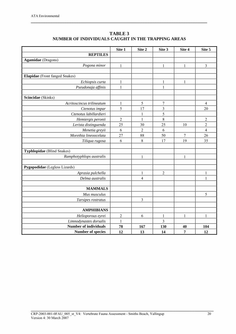
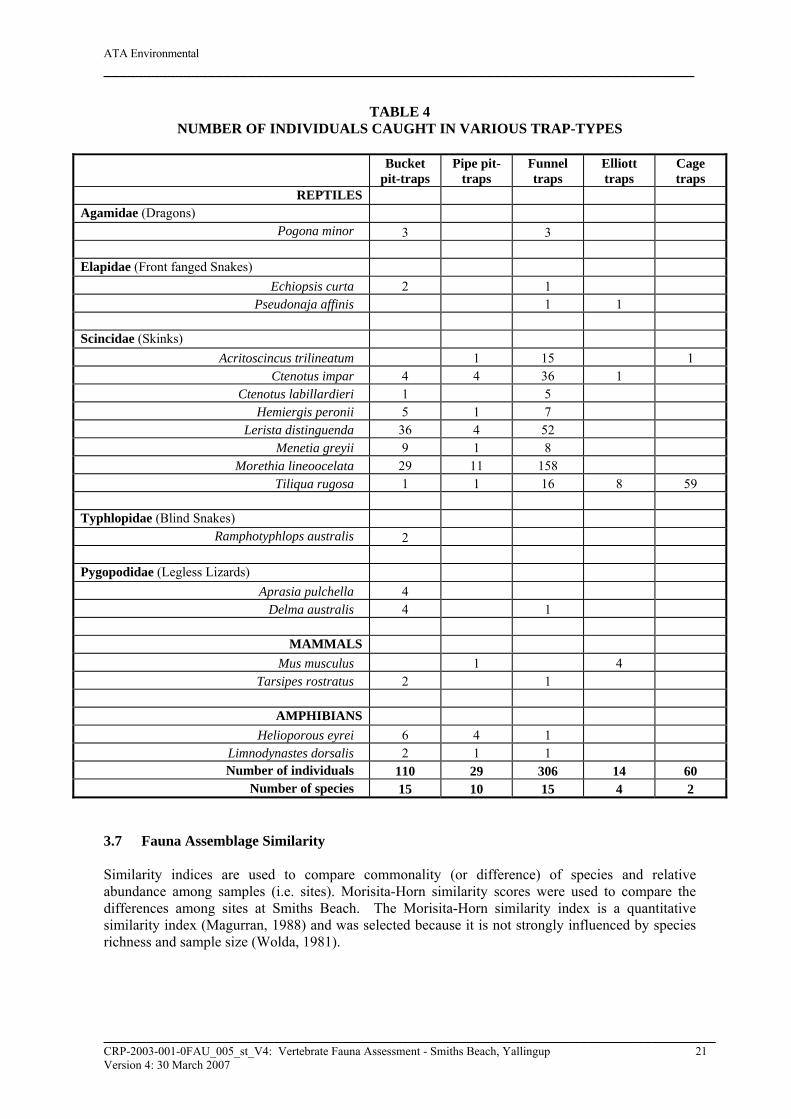
3. RESULTS 3.1 Overall Eighteen species and 519 individual terrestrial vertebrates were trapped over the ten day period. An additional 86 individuals and nine trappable species were observed as part of opportunistic searches or spotlighting. Additional species, including Egernia kingii and E. napoleonis were observed just outside of the study area. These two species are common in the granite rocks to the north west of the study area, however, they were not observed within the study area as no similar habitat is available. 3.2 Nocturnal Searches Nocturnal searches indicated a high number of rabbits and Western Grey Kangaroos in the study area. Limited bat activity was observed, however, two echolocation calls from Chalinolobus morio (Chocolate wattled bat) were recorded. Three Helioporous eyrei and one Christinus marmoratus were the only herpetofauna observed. Although only two foxes and one cat were observed spotlighting, multiple sets of tracks were observed regularly in the mornings indicating that these species were active throughout the area. Western Ringtail Possums are addressed in section 3.12 below. 3.3 Avifauna Bird species sighted within the vicinity of the study area are listed in Appendix 2. It should be noted that the Indian Ocean and associated coastline is adjacent to the west and north of the study area. Birds that frequent the sea and beach occasionally fly over the study area but do not actively forage in this area. Species presented in the search of FaunaBase and in other reports for the region have been included in the appendices. It is acknowledged that some of these species are unlikely to use the study area because of a lack of suitable habitat. A list of 165 species could potentially found in the general locality, however, not all of these species are expected to be observed, forage or nest in the general area. There are always going to be vagrants present in an area because of unusual weather (e.g. flooding, storms). Of these 165 species, 30 species and 1038 individuals were observed in the vicinity of one of the five trapping study areas. A number of bird species have been reported in the general region that was not recorded in FaunaBase for the search area. This is to be expected as species lists for the region are compiled over many years and many of the species listed have seasonal shifts in foraging and breeding study areas. 3.4 Reptiles Reptile species caught at Smiths Beach during the November/December 2005 survey are listed in Tables 3 and 4 and Appendix 2. Fourteen species of reptiles were caught during the field survey. Three hundred and three of the 496 individuals recorded from captures were caught in funnel traps, 92 in bucket pit-traps, 23 in pipe pit-traps, 60 in cage traps and 10 in Elliott traps (Table 4). Species in FaunaBase likely to be caught in the region are listed in Appendix 2 along with reptile species reported as being caught in the region in similar habitats during other fauna surveys.
______________________________________________________________________________________ CRP-2003-001-0FAU_005_st_V4: Vertebrate Fauna Assessment - Smiths Beach, Yallingup 18 Version 4: 30 March 2007
ATA Environmental __________________________________________________________________________
Christinus marmoratus and Echiopsis coronatus were not trapped and one individual of each was observed opportunistically. 3.5 Mammals Larger mammal species (e.g. kangaroos and rabbits) are unlikely to be caught in pit, funnel, Elliott or cage traps, but their scratchings, burrows and scats provide evidence of their presence in an area. Spotlighting at night is also a useful method of detecting the presence of many of these species. Mammals caught during the November/December 2005 survey and in the vicinity of the five trapping sites are shown in Tables 3 and 4, and Appendix 2. Two species of mammals were caught, House Mice (Mus musculus) and Honey Possums (Tarsipes rostratus). Numerous rabbits, two foxes and three cats were sighted in the night searches. ATA Environmental recorded two echolocation calls from Chalinolobus morio (Chocolate Wattled Bat) in the study area. Western Grey Kangaroos are plentiful on study area and were regularly seen during spotlighting and early in the mornings. Western Ringtail Possums and Brushtail Possums were also recorded each evening. The location of the five Brushtail Possums observed is shown in Figure 4. Descriptions of Western Ringtail Possums and their dreys are provided in Tables 8 and 9. During additional spotlighting and opportunistic investigations in January 2006, a Brush-tailed Phascogale and Western Pygmy Possum were recorded on the study area. 3.6 Amphibians Amphibian species caught at Smiths Beach during the November/December 2005 survey are listed in Tables 3 and 4, and Appendix 2. Two species of amphibians (Heleiporus eyrei and Limnodynastes dorsalis) were caught during the field survey. All frogs trapped were in pit-traps (buckets and pipes) or funnel traps (Table 4). Although, not trapped, Litoria adelaidensis and Litoria moorei were common around the old farm dam. The farm dam constructed in 1962 by the previous owners is located in the northern part of the study area adjacent to the former caravan park. The dam is approximately 10m in diameter at its widest point and approximately 1m deep. Species in FaunaBase likely to be caught in the region are listed in Appendix 2 along with species reported as being caught in the region during other surveys.
______________________________________________________________________________________ CRP-2003-001-0FAU_005_st_V4: Vertebrate Fauna Assessment - Smiths Beach, Yallingup 19 Version 4: 30 March 2007
ATA Environmental __________________________________________________________________________
TABLE 3 NUMBER OF INDIVIDUALS CAUGHT IN THE TRAPPING AREAS
Site 1 Site 2 Site 3 Site 4 Site 5
REPTILES Agamidae (Dragons) Pogona minor 1 1 1 3 Elapidae (Front fanged Snakes) Echiopsis curta 1 1 1 Pseudonaja affinis 1 1 Scincidae (Skinks) Acritoscincus trilineatum 1 5 7 4 Ctenotus impar 5 17 3 20 Ctenotus labillardieri 1 5 Hemiergis peronii 2 1 8 2 Lerista distinguenda 25 30 25 10 2 Menetia greyii 6 2 6 4 Morethia lineoocelata 27 88 50 7 26 Tiliqua rugosa 6 8 17 19 35 Typhlopidae (Blind Snakes) Ramphotyphlops australis 1 1 Pygopodidae (Legless Lizards) Aprasia pulchella 1 2 1 Delma australis 4 1
MAMMALS Mus musculus 5 Tarsipes rostratus 3
AMPHIBIANS Helioporous eyrei 2 6 1 1 1 Limnodynastes dorsalis 1 3 Number of individuals 78 167 130 40 104 Number of species 12 13 14 7 12
______________________________________________________________________________________ CRP-2003-001-0FAU_005_st_V4: Vertebrate Fauna Assessment - Smiths Beach, Yallingup 20 Version 4: 30 March 2007
ATA Environmental __________________________________________________________________________
TABLE 4 NUMBER OF INDIVIDUALS CAUGHT IN VARIOUS TRAP-TYPES
Bucket pit-traps
Pipe pit-traps
Funnel traps
Elliott traps
Cage traps
REPTILES Agamidae (Dragons) Pogona minor 3 3 Elapidae (Front fanged Snakes) Echiopsis curta 2 1 Pseudonaja affinis 1 1 Scincidae (Skinks) Acritoscincus trilineatum 1 15 1 Ctenotus impar 4 4 36 1 Ctenotus labillardieri 1 5 Hemiergis peronii 5 1 7 Lerista distinguenda 36 4 52 Menetia greyii 9 1 8 Morethia lineoocelata 29 11 158 Tiliqua rugosa 1 1 16 8 59 Typhlopidae (Blind Snakes) Ramphotyphlops australis 2 Pygopodidae (Legless Lizards) Aprasia pulchella 4 Delma australis 4 1
MAMMALS Mus musculus 1 4 Tarsipes rostratus 2 1
AMPHIBIANS Helioporous eyrei 6 4 1 Limnodynastes dorsalis 2 1 1 Number of individuals 110 29 306 14 60 Number of species 15 10 15 4 2
3.7 Fauna Assemblage Similarity Similarity indices are used to compare commonality (or difference) of species and relative abundance among samples (i.e. sites). Morisita-Horn similarity scores were used to compare the differences among sites at Smiths Beach. The Morisita-Horn similarity index is a quantitative similarity index (Magurran, 1988) and was selected because it is not strongly influenced by species richness and sample size (Wolda, 1981).
______________________________________________________________________________________ CRP-2003-001-0FAU_005_st_V4: Vertebrate Fauna Assessment - Smiths Beach, Yallingup 21 Version 4: 30 March 2007
ATA Environmental __________________________________________________________________________
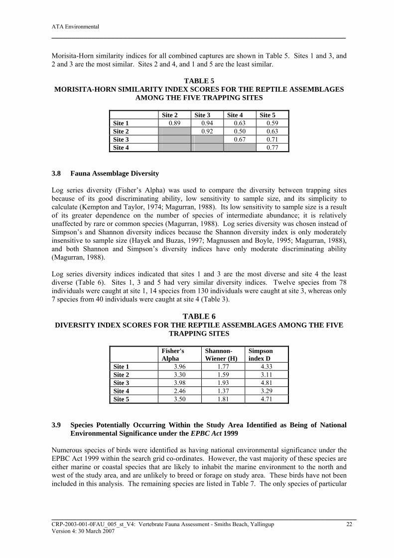
Morisita-Horn similarity indices for all combined captures are shown in Table 5. Sites 1 and 3, and 2 and 3 are the most similar. Sites 2 and 4, and 1 and 5 are the least similar.
TABLE 5 MORISITA-HORN SIMILARITY INDEX SCORES FOR THE REPTILE ASSEMBLAGES
AMONG THE FIVE TRAPPING SITES
Site 2 Site 3 Site 4 Site 5 Site 1 0.89 0.94 0.63 0.59 Site 2 0.92 0.50 0.63 Site 3 0.67 0.71 Site 4 0.77
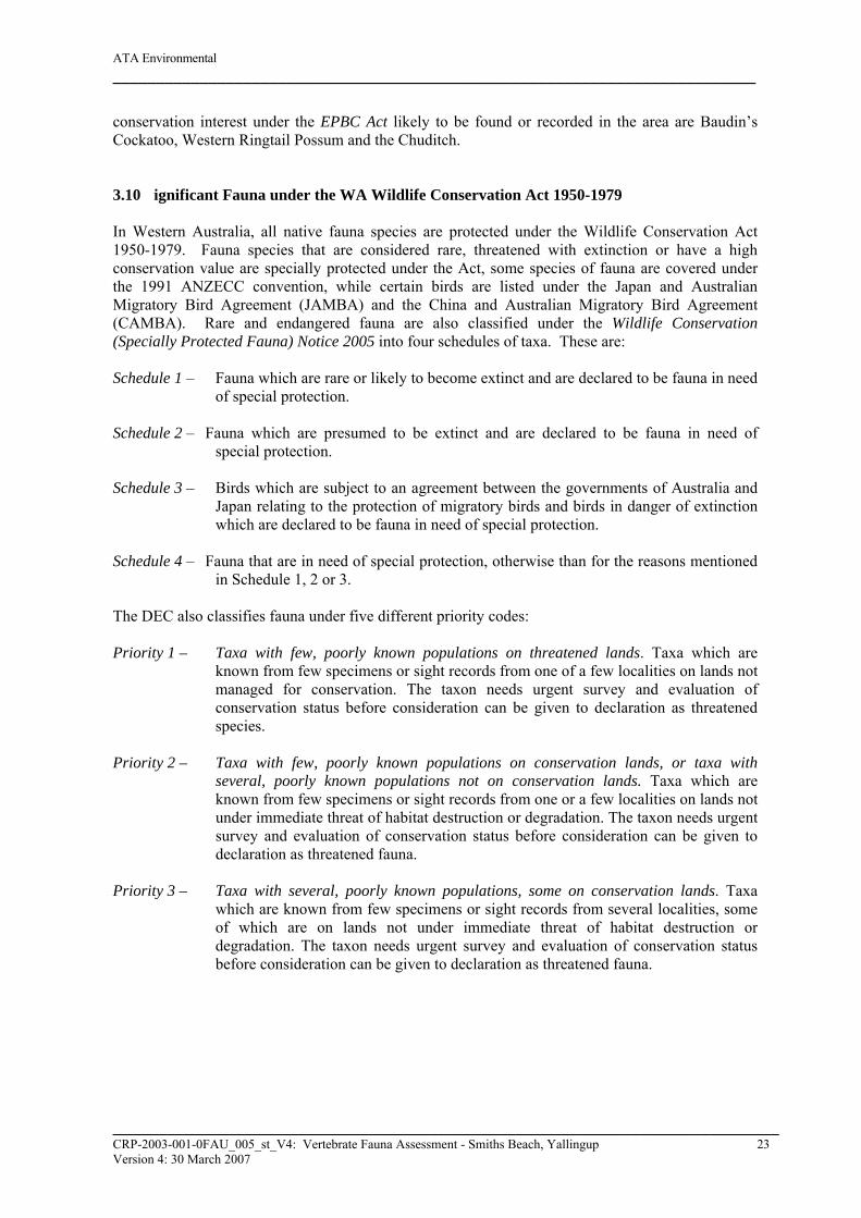
3.8 Fauna Assemblage Diversity Log series diversity (Fisher’s Alpha) was used to compare the diversity between trapping sites because of its good discriminating ability, low sensitivity to sample size, and its simplicity to calculate (Kempton and Taylor, 1974; Magurran, 1988). Its low sensitivity to sample size is a result of its greater dependence on the number of species of intermediate abundance; it is relatively unaffected by rare or common species (Magurran, 1988). Log series diversity was chosen instead of Simpson’s and Shannon diversity indices because the Shannon diversity index is only moderately insensitive to sample size (Hayek and Buzas, 1997; Magnussen and Boyle, 1995; Magurran, 1988), and both Shannon and Simpson’s diversity indices have only moderate discriminating ability (Magurran, 1988). Log series diversity indices indicated that sites 1 and 3 are the most diverse and site 4 the least diverse (Table 6). Sites 1, 3 and 5 had very similar diversity indices. Twelve species from 78 individuals were caught at site 1, 14 species from 130 individuals were caught at site 3, whereas only 7 species from 40 individuals were caught at site 4 (Table 3).
TABLE 6 DIVERSITY INDEX SCORES FOR THE REPTILE ASSEMBLAGES AMONG THE FIVE
TRAPPING SITES
Fisher's Alpha
Shannon-Wiener (H)
Simpson index D
Site 1 3.96 1.77 4.33 Site 2 3.30 1.59 3.11 Site 3 3.98 1.93 4.81 Site 4 2.46 1.37 3.29 Site 5 3.50 1.81 4.71
3.9 Species Potentially Occurring Within the Study Area Identified as Being of National
Environmental Significance under the EPBC Act 1999 Numerous species of birds were identified as having national environmental significance under the EPBC Act 1999 within the search grid co-ordinates. However, the vast majority of these species are either marine or coastal species that are likely to inhabit the marine environment to the north and west of the study area, and are unlikely to breed or forage on study area. These birds have not been included in this analysis. The remaining species are listed in Table 7. The only species of particular
______________________________________________________________________________________ CRP-2003-001-0FAU_005_st_V4: Vertebrate Fauna Assessment - Smiths Beach, Yallingup 22 Version 4: 30 March 2007
ATA Environmental __________________________________________________________________________
conservation interest under the EPBC Act likely to be found or recorded in the area are Baudin’s Cockatoo, Western Ringtail Possum and the Chuditch. 3.10 ignificant Fauna under the WA Wildlife Conservation Act 1950-1979 In Western Australia, all native fauna species are protected under the Wildlife Conservation Act 1950-1979. Fauna species that are considered rare, threatened with extinction or have a high conservation value are specially protected under the Act, some species of fauna are covered under the 1991 ANZECC convention, while certain birds are listed under the Japan and Australian Migratory Bird Agreement (JAMBA) and the China and Australian Migratory Bird Agreement (CAMBA). Rare and endangered fauna are also classified under the Wildlife Conservation (Specially Protected Fauna) Notice 2005 into four schedules of taxa. These are: Schedule 1 – Fauna which are rare or likely to become extinct and are declared to be fauna in need
of special protection. Schedule 2 – Fauna which are presumed to be extinct and are declared to be fauna in need of
special protection. Schedule 3 – Birds which are subject to an agreement between the governments of Australia and
Japan relating to the protection of migratory birds and birds in danger of extinction which are declared to be fauna in need of special protection.
Schedule 4 – Fauna that are in need of special protection, otherwise than for the reasons mentioned
in Schedule 1, 2 or 3. The DEC also classifies fauna under five different priority codes:
Priority 1 – Taxa with few, poorly known populations on threatened lands. Taxa which are
known from few specimens or sight records from one of a few localities on lands not managed for conservation. The taxon needs urgent survey and evaluation of conservation status before consideration can be given to declaration as threatened species.
Priority 2 – Taxa with few, poorly known populations on conservation lands, or taxa with
several, poorly known populations not on conservation lands. Taxa which are known from few specimens or sight records from one or a few localities on lands not under immediate threat of habitat destruction or degradation. The taxon needs urgent survey and evaluation of conservation status before consideration can be given to declaration as threatened fauna.
Priority 3 – Taxa with several, poorly known populations, some on conservation lands. Taxa
which are known from few specimens or sight records from several localities, some of which are on lands not under immediate threat of habitat destruction or degradation. The taxon needs urgent survey and evaluation of conservation status before consideration can be given to declaration as threatened fauna.
______________________________________________________________________________________ CRP-2003-001-0FAU_005_st_V4: Vertebrate Fauna Assessment - Smiths Beach, Yallingup 23 Version 4: 30 March 2007
ATA Environmental __________________________________________________________________________
Priority 4 and 5 – Taxa in need of monitoring. Taxa which are considered to have been adequately surveyed or for which sufficient knowledge is available and which are considered not currently threatened or in need of special protection, but could if present circumstances change. These taxa are usually represented on conservation lands. Taxa which are declining significantly but are not yet threatened.
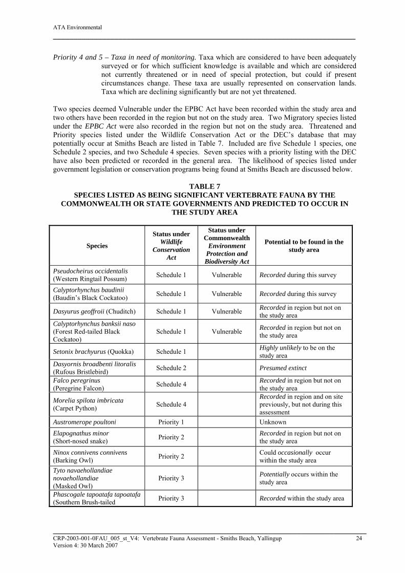
Two species deemed Vulnerable under the EPBC Act have been recorded within the study area and two others have been recorded in the region but not on the study area. Two Migratory species listed under the EPBC Act were also recorded in the region but not on the study area. Threatened and Priority species listed under the Wildlife Conservation Act or the DEC’s database that may potentially occur at Smiths Beach are listed in Table 7. Included are five Schedule 1 species, one Schedule 2 species, and two Schedule 4 species. Seven species with a priority listing with the DEC have also been predicted or recorded in the general area. The likelihood of species listed under government legislation or conservation programs being found at Smiths Beach are discussed below.
TABLE 7 SPECIES LISTED AS BEING SIGNIFICANT VERTEBRATE FAUNA BY THE
COMMONWEALTH OR STATE GOVERNMENTS AND PREDICTED TO OCCUR IN THE STUDY AREA
Species
Status under Wildlife
Conservation Act
Status under Commonwealth
Environment Protection and Biodiversity Act
Potential to be found in the study area
Pseudocheirus occidentalis (Western Ringtail Possum) Schedule 1 Vulnerable Recorded during this survey
Calyptorhynchus baudinii (Baudin’s Black Cockatoo) Schedule 1 Vulnerable Recorded during this survey
Dasyurus geoffroii (Chuditch) Schedule 1 Vulnerable Recorded in region but not on the study area
Calyptorhynchus banksii naso (Forest Red-tailed Black Cockatoo)
Schedule 1 Vulnerable Recorded in region but not on the study area
Setonix brachyurus (Quokka) Schedule 1 Highly unlikely to be on the study area
Dasyornis broadbenti litoralis (Rufous Bristlebird) Schedule 2 Presumed extinct
Falco peregrinus (Peregrine Falcon) Schedule 4 Recorded in region but not on
the study area
Morelia spilota imbricata (Carpet Python) Schedule 4
Recorded in region and on site previously, but not during this assessment
Austromerope poultoni Priority 1 Unknown
Elapognathus minor (Short-nosed snake) Priority 2 Recorded in region but not on
the study area
Ninox connivens connivens (Barking Owl) Priority 2 Could occasionally occur
within the study area Tyto navaehollandiae novaehollandiae (Masked Owl)
Priority 3 Potentially occurs within the study area
Phascogale tapoatafa tapoatafa (Southern Brush-tailed Priority 3 Recorded within the study area
______________________________________________________________________________________ CRP-2003-001-0FAU_005_st_V4: Vertebrate Fauna Assessment - Smiths Beach, Yallingup 24 Version 4: 30 March 2007
ATA Environmental __________________________________________________________________________
Species
Status under Wildlife
Conservation Act
Status under Commonwealth
Environment Protection and Biodiversity Act
Potential to be found in the study area
Phascogale)
Macropus irma (Western Brush Wallaby) Priority 4 Recorded in region but not on
the study area
Ctenotus delli (Dell’s Skink) Priority 4 Recorded in region but not on the study area
Isoodon obesulus fusciventer (Southern Brown Bandicoot) Priority 5 Recorded in region but not on
the study area Falsistrellus mackenziei (Western False Pipistrelle) Priority 4 Potentially occurs within the
study area
Haliaeetus leucogaster (White-bellied Sea Eagle) Migratory
Unlikely to rely on the study area for survival although regionally present
Merops ornatus (Rainbow Bee-eater) Migratory
Unlikely to rely on the study area for survival although regionally present
3.11 Likelihood of Significant Fauna Occurring in the Study Area The following is a brief description of the preferred habitat of species listed in Table 7 and an assessment of the likelihood of these species being found on the study area. Baudin’s Black-Cockatoo (Calyptorhynchus baudinii) – This species is most common in the far
south-west of Western Australia where it breeds in the hollows of Karri (E. diversicolor), Marri (C. calophylla) and Wandoo (E. wandoo). It is known to breed from the southern forests north to Collie and east to near Kojonup. Baudin’s Black-Cockatoo is typically found in vagrant flocks and utilises the taller, more open Jarrah and Marri woodlands, where it feeds mainly on Marri seeds and various Proteaceous species.
Baudin’s Black-Cockatoos were recorded feeding on Marri and Banksia within the study area and within the surrounding Leeuwin-Naturaliste National Park. ecologia Environmental Consultants also recorded these Cockatoos on the study area in April 2001. There are no trees on-site that would provide tree hollows of suitable diameter or height for breeding purposes. No breeding Cockatoos were recorded during this assessment.
Chuditch or Western Quoll (Dasyurus geoffroii) – Formally known from over 70% of Australia,
the Chuditch now has a patchy distribution throughout the Jarrah forest and mixed Karri/Marri/Jarrah forest of south-west WA. Their habitat is described by Strahan (2000) as sclerophyll forest or dried woodland and mallee shrubland. They den in hollow logs and burrows and have also been recorded in tree hollows and cavities (www.calm.wa.gov.au/plants_animals/pdf_files/ sp_chuditch.pdf). A search of FaunaBase indicated that they have been caught in the general vicinity, however they are generally not found in the coastal dunes or abutting forests so they are unlikely to be in the area. The DEC has recorded Chuditch at Yallingup in 1985 and 1986.
Although, not recorded on study area by ecologia Environmental Consultants (2001) or ATA Environmental’s (2005) assessments, the Chuditch potentially inhabits the woodlands
______________________________________________________________________________________ CRP-2003-001-0FAU_005_st_V4: Vertebrate Fauna Assessment - Smiths Beach, Yallingup 25 Version 4: 30 March 2007
ATA Environmental __________________________________________________________________________
both in the study and in adjacent areas as there are appropriate size and quality habitat available.
Forest Red-tailed Black-Cockatoo (Calptorhynchus banksii naso) – Forest Red-tailed Black-
Cockatoos frequent the humid to subhumid south-west feeding on a variety of Eucalyptus species, from Gingin in the north, Albany in the south and west to Cape Leeuwin and Bunbury. Nesting occurs in hollows with a depth of 1-5m predominately in Marri (C. calophylla), Jarrah (E. marginata) and Karri (E. diversicolor). Forest Red-tailed Black-Cockatoos were formerly common but are now uncommon and patchily distributed.
Although, not recorded in the DEC’s Threatened fauna database search, or on-site during ecologia Environmental Consultants (2001) or ATA Environmental’s (2005) assessments, the Forest Red-tailed Black-Cockatoo may utilise the study area for feeding purposes as suitable feeding habitat is present.
Quokka (Setonix brachyurus) - Once very common in areas such as the Swan Coastal Plain near Perth and Gingin, Quokkas are now uncommon on the mainland and confined to isolated pockets within the south-west corner of WA. Densely vegetated areas around swamps or streams are preferred. There have been no recorded sightings of the Quokka in the region since 1933.
The Quokka is highly unlikely to occur on the study area.
Rufous Bristlebird (Dasyornis broadbenti litorlis) – Presumed extinct, this species favoured low coastal heaths, in the lower west coast near Capes Naturaliste and Mentelle. The last confirmed sightings were in 1906 (Johnstone and Storr, 2004). The Rufous Bristlebird is extinct and therefore is highly unlikely to occur on the study area.
Peregrine Falcon (Falco peregrinus) – This species is uncommon, although widespread throughout much of Australia, excluding the extremely dry areas and has a wide and patchy distribution. It shows a habitat preference for areas near cliffs along coastlines, rivers and ranges and within woodlands along watercourses and around lakes.
The Peregrine Falcon is possibly an infrequent visitor to the study area.
Carpet Python (Morelia spilota imbricata) – The South-west Carpet Python is a large snake found across the south-west of Western Australia, north to Geraldton and Yalgoo, and east to Kalgoorlie, Fraser Range and Eyre. They inhabit forest, heath, or wetland areas and shelter in hollow logs or in branches of large trees. Carpet Pythons are often found in colonies, particularly when breeding in spring. This species is widespread within the southwest, but is not in high density across its distribution. ATA Environmental has multiple anecdotal reports of them being caught on study area and in the surrounding area (DEC staff, amateur herpetologists). ATA Environmental has also sighted them south of Smiths Beach around Gracetown.
The Carpet Python is known to inhabit the study area and is expected to utilise all existing habitat types on the study area.
Austromerope poultoni – This species of scorpion fly is associated with forest litter and appears to
be active after rainy periods. Little else is known of its biology and habitat requirements.
______________________________________________________________________________________ CRP-2003-001-0FAU_005_st_V4: Vertebrate Fauna Assessment - Smiths Beach, Yallingup 26 Version 4: 30 March 2007
ATA Environmental __________________________________________________________________________
Given the lack of knowledge on this species, it is unknown whether this species occurs on the study area.
Short-nosed snake (Elapognathus minor) – This species inhabits the humid coastal plains of the deep southwest, north to Busselton and east to Two Peoples Bay. This species is at the northern limits of its range. This species is unlikely to inhabit the study area due to its habitat preference and distribution.
Barking Owl (southwest population; Ninox connivens connivens) – This species inhabits forest and woodland and is becoming increasingly rare in the south-west. It preys on invertebrates and small mammals. It was recorded at Cape Naturaliste in 1995 and Dunsborough in 1996.
Barking Owls could occasionally occur within the study area.
Masked Owl (Tyto novaehollandiae) – Little information is available on the Masked Owl. It is
distributed from Yanchep east to Yealering, south to Gnowangerup and Albany and occasionally seen north to Geraldton. This species inhabits forests and woodlands, and nests in tree hollows. It is locally common around Karridale and Manjimup, but is generally uncommon elsewhere.
Although there are no hollow trees or branches present that would be suitable for nesting, Masked Owls could occasionally occur within the study area.
Southern Brush-tailed Phascogale (Phascogale tapoatafa tapoatafa) – The present range of this species is believed to have been reduced to 50% of its former range and it is now known from Perth and south to Albany, west of Albany Highway. It occurs at high densities in the Perup/Kingston area, Collie River valley, and near Margaret River and Busselton. This arboreal marsupial has been observed in dry sclerophyll forests and open woodland that contain hollow-bearing trees but a sparse ground cover. One individual was recorded in the area during spotlighting in January 2006 in dense thicket on limestone soils along the mid-southern boundary of the study area. Dense thickets are atypical of Brush-tailed Phascogales and it is presumed that this individual was a transient in this vegetation type.
Western Brush Wallaby (Macropus irma) – This species was very common in the early days of settlement however its range has been seriously reduced and fragmented due to clearing for agriculture and there is a significant decline in abundance within most remaining habitat. It is now distributed across the south-west of WA from north of Kalbarri to Cape Arid. The optimum habitat is open forest or woodland, particularly favouring open, seasonally wet flats with low grasses and open scrubby thickets.
Although no Western Brush Wallabies were observed during the assessments they are potentially found in the study area as the habitat is dense and large enough to sustain a population. Dell’s Skink (Ctenotus delli) – The main distribution of this skink is within the Darlington/Mundaring Weir area to near Collie. Isolated records are also found in the south west including three individuals in the Meelup Regional Park (Hart, Simpson and Associates, 1995).
______________________________________________________________________________________ CRP-2003-001-0FAU_005_st_V4: Vertebrate Fauna Assessment - Smiths Beach, Yallingup 27 Version 4: 30 March 2007
ATA Environmental __________________________________________________________________________
Given that similar habitat is found in the Yallingup region, Dell’s Skinks could possibly occur within the study area, but it is considered unlikely.
Quenda or Southern Brown Bandicoot (Isoodon obesulus fusciventer) – Quenda preferred habitat
is dense scrub and undergrowth. They will often feed in adjacent forest and woodland and in areas of pasture and crop land lying close to dense cover. This species has been recorded in the vicinity in FaunaBase. Quenda have been reported from the region in 2002.
Although no scats and scratchings were observed, the Quenda may be present in the more densely vegetated shrubby areas on the study area.
Western False Pipistrelle (Falsistrellus mackenziei) – This bat species lives in hollows in old trees, branches and stumps. It is normally found in colonies of 5 to 30 bats. Western False Pipistrelles are vulnerable to loss of roosting study areas in tree hollows and loss of feeding grounds by forestry activities, clearing for agriculture and housing. They live mainly in wet sclerophyll forests of Karri, Jarrah and Tuart eucalypts.
The Western False Pipistrelles are unlikely to occur within the study area as there are limited hollows present on the study area.
White-bellied Sea Eagle (Haliaeetus leucogaster) – White-bellied Sea Eagles are most commonly
found around the coastline however, they have been reported many kilometres inland.
The White-bellied Sea Eagle may fly over the study area, however, they are unlikely to rely on the study area for feeding or roosting. Rainbow Bee-eater (Merops ornatus) – The Rainbow Bee-eater is a migratory bird that arrives in the south-west of WA in late September – early October and nests in a burrow dug in the ground. It is found in a wide variety of sandy habitats on the Swan Coastal Plain and south west. This species is listed as a Migratory species under the EPBC Act. There is limited potential for the Rainbow Bee-eater to rely on the study area due to hard substrate and limited potential for nesting.
Of the species listed under Commonwealth and State government legislation requiring special protection due to their vulnerability, Baudin’s Black Cockatoo and the Western Ringtail Possum were recorded on-site. No significant trees containing hollows suitable for breeding Cockatoos were recorded within the study area, however, there are many available in the surrounding Leeuwin-Naturaliste National Park. Baudin’s Cockatoos were observed feeding on the vegetation within the study area and surrounding the area most days. They were observed in both the Banksia and Marri vegetation. Although they utilise the area for feeding they have a range of alternative feeding and roosting areas in the region, including Leeuwin-Naturaliste National Park.
______________________________________________________________________________________ CRP-2003-001-0FAU_005_st_V4: Vertebrate Fauna Assessment - Smiths Beach, Yallingup 28 Version 4: 30 March 2007
ATA Environmental __________________________________________________________________________
3.12 Western Ringtail Possum Survey A number of Western Ringtail Possums were identified as actively utilising Smiths Beach and the surrounding habitats. The Western Ringtail Possum is listed as a Schedule 1 species (‘Fauna that is rare or likely to become extinct’) under the Western Australian Wildlife Conservation Act 1950, and as ‘Vulnerable’ under the Commonwealth EPBC Act 1999. It is also listed as ‘Vulnerable’ in the IUCN Red List of Threatened Species. The Western Ringtail Possum is closely associated with stands of Native Peppermint trees (Agonis flexuosa), which is the dominant overstorey species remaining in the eastern half of the study area. The Western Ringtail Possum also inhabits the suburban areas of Busselton and Dunsborough often in highly modified urban environments in remnant Peppermint trees. Western Ringtail Possums are nocturnal and usually shelter by day in dreys (bird-like nests) or tree hollows. The dreys are typically located in the crown of Peppermint trees, but may be constructed in other tree species, including Melaleuca, Banksia, Marri and Jarrah trees. Where the vegetation is not suitable to make dreys or where hollows are common, tree hollows may also be utilised as rest study areas by Western Ringtail Possums. Western Ringtail Possums are territorial and have defined, overlapping home ranges of 0.5-1.5ha that extend to about 60m from the nearest drey tree. There may be a number of dreys within one home range. The leaves of Peppermint trees are the primary food source of the species, but individuals in residential areas may feed on garden plants, fruit and vegetables in compost heaps. 3.13 Western Ringtail Possum Dreys A total of 50 possum dreys were located on study area during the daylight searches in November/December 2005. In addition 50 dreys were located in native vegetation adjacent to the study area in the surrounding habitats in the Leeuwin-Naturaliste National Park. Locations and descriptions of each of the dreys are provided in Table 8 and 9 and their locations shown on Figure 4. On Sussex Location 413, dreys were recorded in Peppermints (9), Melaleucas (2), Marris (6), Banksias (2), Hakea oleifolia (6), on the ground (1) and Spyridium globulosum (24). The dreys were generally located in the Peppermint/Eucalypt Woodland. In the habitat adjacent to Sussex Location 413, dreys were recorded in Peppermints (12), Banksias (14), Hakea oleifolia (6), and Spyridium globulosum (18).
TABLE 8 DREY AND HOLLOW LOCATIONS AND DESCRIPTIVE COMMENTS FOR DREYS
FOUND ON SUSSEX LOCATION 413
Drey numbers Location Comment
1 S33°39.801' E115°00.858' Drey type 2; 4.5 m high in a Peppermint 2 S33°39.803' E115°00.848' Drey type 1; 3m high in a Peppermint 3 S33°39.827' E115°00.831' Drey type 2; 3.5m high in a Spyridium globulosum 4 S33°39.853' E115°00.853' Drey type 4; 5m high in a Spyridium globulosum 5 S33°39.803' E115°00.882' Drey type 1; 7m high in a Hakea oleifolia 6 S33°39.803' E115°00.866' Drey type 4; 4m high in a Spyridium globulosum 7 S33°39.816' E115°00.878' Drey type 3; 4.5m high in a Hakea oleifolia
______________________________________________________________________________________ CRP-2003-001-0FAU_005_st_V4: Vertebrate Fauna Assessment - Smiths Beach, Yallingup 29 Version 4: 30 March 2007

ATA Environmental __________________________________________________________________________
Drey numbers Location Comment
8 S33°39.911' E115°00.866' Drey type 2; 8m high in a Peppermint 9 S33°39.881' E115°00.863' Drey type 1; 7m high in a Spyridium globulosum
10 S33°39.877' E115°00.858' Drey type 1; 9m high in a Peppermint 11 S33°39.898' E115°00.832' Drey type 3; 2.5m high in a Melaleuca 12 S33°39.892' E115°00.806' Drey type 3; 5m high in a Hakea oleifolia 13 S33°39.847' E115°00.805' Drey type 1; 3m high in a Spyridium globulosum 15 S33°39.810' E115°00.796' Drey type 2; 5m high in a Spyridium globulosum 16 S33°39.807' E115°00.811' Drey type 2; 4m high in a Spyridium globulosum 17 S33°39.804' E115°00.828' Drey type 1; 4m high in a Spyridium globulosum 18 S33°39.793' E115°00.831' Drey type 1; 3m high in a Spyridium globulosum 19 S33°39.788' E115°00.829' Drey type 1; 5m high in a Spyridium globulosum 20 S33°39.768' E115°00.817' Drey type 2; 2m high in a Peppermint 21 S33°39.761' E115°00.801' Drey type 1; 8m high in a Peppermint 22 S33°39.763' E115°00.792' Drey type 1; 9m high in a Peppermint 23 S33°39.779' E115°00.796' Drey type 4; 4m high in a Hakea oleifolia 24 S33°39.783' E115°00.816' Drey type 2; 3m high in a Spyridium globulosum 25 S33°39.804' E115°00.844' Drey type 2; 4.5m high in a Peppermint 26 S33°39.847' E115°00.793' Drey type 1; 4m high in a Spyridium globulosum 27 S33°39.880' E115°00.857' Drey type 2; 5m high in a Marri 28 S33°39.823' E115°00.848' Drey type 2; 3m high in a Spyridium globulosum 29 S33°39.781' E115°00.783' Drey type 1; 3m high in a Spyridium globulosum 30 S33°39.801' E115°00.793' Drey type 2; 5m high in a Spyridium globulosum 31 S33°39.777' E115°00.780' Drey type 3; 3m high in a Spyridium globulosum 32 S33°39.769' E115°00.771' Drey type 4; 5m high in a Marri 33 S33°39.782' E115°00.757' Drey type 2; 5m high in a Banksia 34 S33°39.787' E115°00.766' Drey type 1; 4m high in a Marri 35 S33°39.794' E115°00.777' Drey type 2; 4m high in a Marri 36 S33°39.798' E115°00.780' Drey type 1; 3m high in a Spyridium globulosum 37 S33°39.794' E115°00.791' Drey type 2; 3m high in a Spyridium globulosum 38 S33°39.813' E115°00.807' Drey type 4; 3m high in a Spyridium globulosum 39 S33°39.836' E115°00.803' Drey type 1; 3m high in a Spyridium globulosum 42 S33°39.891' E115°00.738' Drey type 1; 5m high in a Melaleuca 43 S33°39.875' E115°00.735' Drey type 1; 7m high in a Hakea oleifolia 44 S33°39.846' E115°00.670' Drey type 4; 8m high in a Marri 45 S33°39.823' E115°00.733' Drey type 3; 3m high in a Spyridium globulosum 46 S33°39.797' E115°00.744' Drey type 1; 6m high in a Banksia 47 S33°39.786' E115°00.745' Drey type 3; 4m high in a Peppermint 48 S33°39.783' E115°00.753' Drey type 3; 3m high in a Marri 49 S33°39.813' E115°00.777' Drey type 2; 3m high in a Spyridium globulosum 50 S33°39.816' E115°00.777' Drey type 2; m high in a fallen from tree and on ground 51 S33°39.820' E115°00.778' Drey type 2; 3m high in a Spyridium globulosum 52 S33°39.829' E115°00.787' Drey type 3; 3m high in a Spyridium globulosum
______________________________________________________________________________________ CRP-2003-001-0FAU_005_st_V4: Vertebrate Fauna Assessment - Smiths Beach, Yallingup 30 Version 4: 30 March 2007
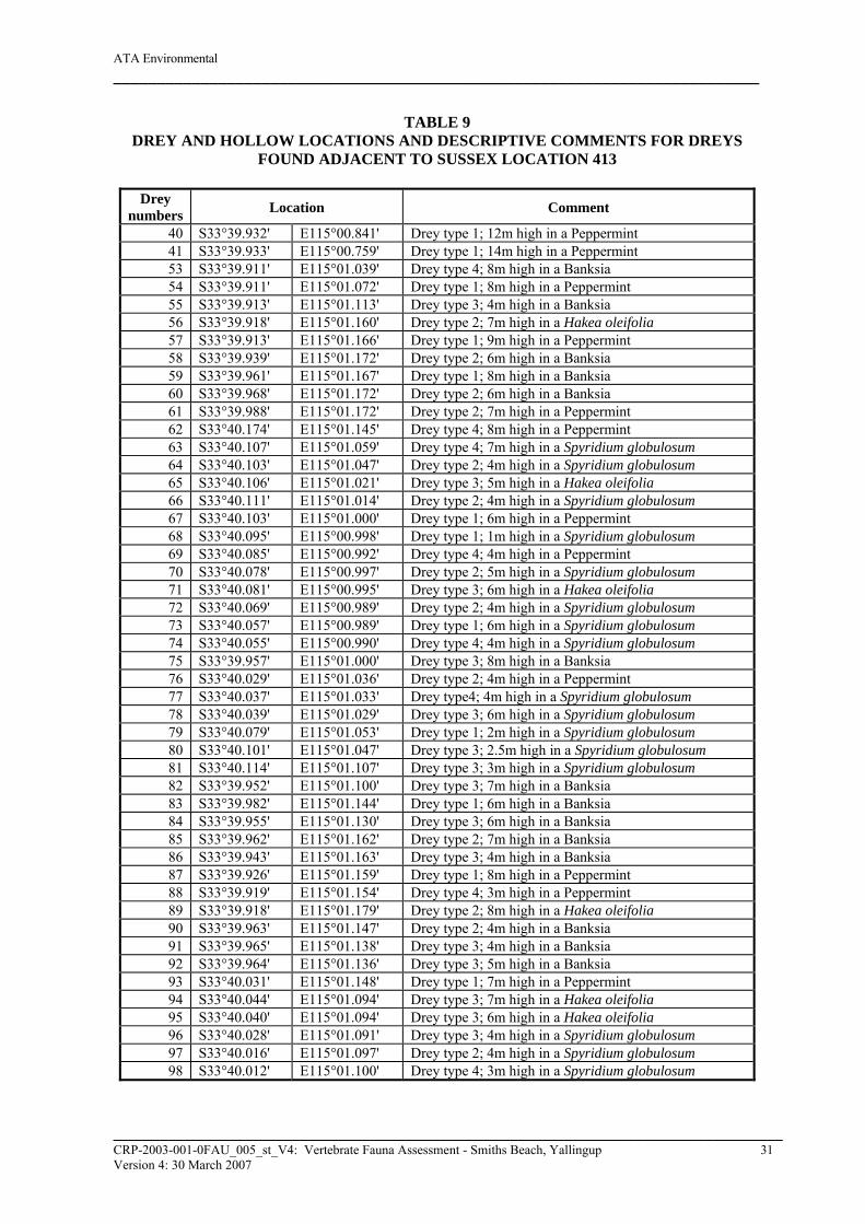
ATA Environmental __________________________________________________________________________
TABLE 9 DREY AND HOLLOW LOCATIONS AND DESCRIPTIVE COMMENTS FOR DREYS
FOUND ADJACENT TO SUSSEX LOCATION 413
Drey numbers Location Comment
40 S33°39.932' E115°00.841' Drey type 1; 12m high in a Peppermint 41 S33°39.933' E115°00.759' Drey type 1; 14m high in a Peppermint 53 S33°39.911' E115°01.039' Drey type 4; 8m high in a Banksia 54 S33°39.911' E115°01.072' Drey type 1; 8m high in a Peppermint 55 S33°39.913' E115°01.113' Drey type 3; 4m high in a Banksia 56 S33°39.918' E115°01.160' Drey type 2; 7m high in a Hakea oleifolia 57 S33°39.913' E115°01.166' Drey type 1; 9m high in a Peppermint 58 S33°39.939' E115°01.172' Drey type 2; 6m high in a Banksia 59 S33°39.961' E115°01.167' Drey type 1; 8m high in a Banksia 60 S33°39.968' E115°01.172' Drey type 2; 6m high in a Banksia 61 S33°39.988' E115°01.172' Drey type 2; 7m high in a Peppermint 62 S33°40.174' E115°01.145' Drey type 4; 8m high in a Peppermint 63 S33°40.107' E115°01.059' Drey type 4; 7m high in a Spyridium globulosum 64 S33°40.103' E115°01.047' Drey type 2; 4m high in a Spyridium globulosum 65 S33°40.106' E115°01.021' Drey type 3; 5m high in a Hakea oleifolia 66 S33°40.111' E115°01.014' Drey type 2; 4m high in a Spyridium globulosum 67 S33°40.103' E115°01.000' Drey type 1; 6m high in a Peppermint 68 S33°40.095' E115°00.998' Drey type 1; 1m high in a Spyridium globulosum 69 S33°40.085' E115°00.992' Drey type 4; 4m high in a Peppermint 70 S33°40.078' E115°00.997' Drey type 2; 5m high in a Spyridium globulosum 71 S33°40.081' E115°00.995' Drey type 3; 6m high in a Hakea oleifolia 72 S33°40.069' E115°00.989' Drey type 2; 4m high in a Spyridium globulosum 73 S33°40.057' E115°00.989' Drey type 1; 6m high in a Spyridium globulosum 74 S33°40.055' E115°00.990' Drey type 4; 4m high in a Spyridium globulosum 75 S33°39.957' E115°01.000' Drey type 3; 8m high in a Banksia 76 S33°40.029' E115°01.036' Drey type 2; 4m high in a Peppermint 77 S33°40.037' E115°01.033' Drey type4; 4m high in a Spyridium globulosum 78 S33°40.039' E115°01.029' Drey type 3; 6m high in a Spyridium globulosum 79 S33°40.079' E115°01.053' Drey type 1; 2m high in a Spyridium globulosum 80 S33°40.101' E115°01.047' Drey type 3; 2.5m high in a Spyridium globulosum 81 S33°40.114' E115°01.107' Drey type 3; 3m high in a Spyridium globulosum 82 S33°39.952' E115°01.100' Drey type 3; 7m high in a Banksia 83 S33°39.982' E115°01.144' Drey type 1; 6m high in a Banksia 84 S33°39.955' E115°01.130' Drey type 3; 6m high in a Banksia 85 S33°39.962' E115°01.162' Drey type 2; 7m high in a Banksia 86 S33°39.943' E115°01.163' Drey type 3; 4m high in a Banksia 87 S33°39.926' E115°01.159' Drey type 1; 8m high in a Peppermint 88 S33°39.919' E115°01.154' Drey type 4; 3m high in a Peppermint 89 S33°39.918' E115°01.179' Drey type 2; 8m high in a Hakea oleifolia 90 S33°39.963' E115°01.147' Drey type 2; 4m high in a Banksia 91 S33°39.965' E115°01.138' Drey type 3; 4m high in a Banksia 92 S33°39.964' E115°01.136' Drey type 3; 5m high in a Banksia 93 S33°40.031' E115°01.148' Drey type 1; 7m high in a Peppermint 94 S33°40.044' E115°01.094' Drey type 3; 7m high in a Hakea oleifolia 95 S33°40.040' E115°01.094' Drey type 3; 6m high in a Hakea oleifolia 96 S33°40.028' E115°01.091' Drey type 3; 4m high in a Spyridium globulosum 97 S33°40.016' E115°01.097' Drey type 2; 4m high in a Spyridium globulosum 98 S33°40.012' E115°01.100' Drey type 4; 3m high in a Spyridium globulosum
______________________________________________________________________________________ CRP-2003-001-0FAU_005_st_V4: Vertebrate Fauna Assessment - Smiths Beach, Yallingup 31 Version 4: 30 March 2007
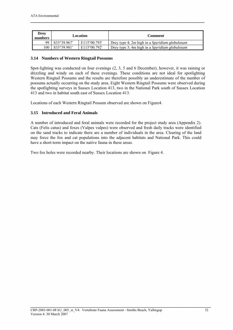
ATA Environmental __________________________________________________________________________
Drey numbers Location Comment
99 S33°39.967' E115°00.793' Drey type 4; 2m high in a Spyridium globulosum 100 S33°39.981' E115°00.792' Drey type 3; 4m high in a Spyridium globulosum
3.14 Numbers of Western Ringtail Possums Spot-lighting was conducted on four evenings (2, 3, 5 and 6 December), however, it was raining or drizzling and windy on each of these evenings. These conditions are not ideal for spotlighting Western Ringtail Possums and the results are therefore possibly an underestimate of the number of possums actually occurring on the study area. Eight Western Ringtail Possums were observed during the spotlighting surveys in Sussex Location 413, two in the National Park south of Sussex Location 413 and two in habitat south east of Sussex Location 413. Locations of each Western Ringtail Possum observed are shown on Figure4. 3.15 Introduced and Feral Animals A number of introduced and feral animals were recorded for the project study area (Appendix 2). Cats (Felis catus) and foxes (Vulpes vulpes) were observed and fresh daily tracks were identified on the sand tracks to indicate there are a number of individuals in the area. Clearing of the land may force the fox and cat populations into the adjacent habitats and National Park. This could have a short-term impact on the native fauna in these areas. Two fox holes were recorded nearby. Their locations are shown on Figure 4.
______________________________________________________________________________________ CRP-2003-001-0FAU_005_st_V4: Vertebrate Fauna Assessment - Smiths Beach, Yallingup 32 Version 4: 30 March 2007
ATA Environmental __________________________________________________________________________
4. DISCUSSION 4.1 Survey Adequacy 4.1.1 Species Accumulation Curves There are numerous statistical tools available to estimate species richness. Species accumulation curves are the most often cited (e.g. How and Cooper, 2002; How and Dell, 2004; McKenzie, Rolfe et al. 2000; Thompson, et al. 2003b) indicator of the adequacy of a fauna survey effort to inventory a particular area in Western Australia and are regularly used in the literature as a method of assessing the adequacy of survey effort to inventory a study area (Colwell and Coddington, 1994; Hayek and Buzas, 1997; Moreno and Halffter, 2000; Soberón and Llorente, 1993). Species accumulation curves, or collectors’ curves, plot the cumulative number of species discovered within a defined sampling area with increasing levels of survey effort thereby providing a measure of species inventory efficacy and completeness, and can be used for comparison among surveys based upon standardised sampling protocols surveys of remnant vegetation in the metropolitan area of the Swan Coastal Plain indicated that many reptiles will survive in remnant plots of vegetation surrounded by residential development. The draft Development Guide Plan for the Smiths Beach study areas indicates that much of the remnant habitat will be preserved. Given that limited habitat will be cleared as part of the development and the fact that similar habitat is available in the adjacent areas (i.e. Leeuwin-Naturaliste National Park), and that the clearing will progressively occur over a long time span (up to 10 years), ATA Environmental believes that there will be limited impact on herpetofauna in the region. 4.2.3 Mammals ATA Environmental trapped two species of mammal (House Mouse and Honey Possum) and opportunistically recorded an additional four species of native mammal (Western Pygmy Possum, Southern Brushtail-Phascogale, Western Ringtail Possum and Brushtail Possum). ecologia Environmental Consultants (2001b), trapped 14 Brushtail Possums, one House Mouse and one Bush Rat. ecologia Environmental Consultants (2001b) and ATA Environmental both observed, rabbits, cats, dogs and foxes across the study area and surrounding areas. ATA only recorded one species of bat (Chocolate Wattled Bat Chalinolobus morio), whereas ecologia Environmental Consultants (2001b) recorded four species (Western Freetail Bat; Mormopterus planiceps, White-striped Mastiff-bat; Tadarida australis, Goulds Wattled Bat; C. gouldii and Southern Forest Bat; Vespedelus regulus). No bats were recorded by Harewood (2005). ecologia Environmental Consultants (2001b) did not observe any Western Ringtail Possums or dreys during a total of 3 person hours of spotlighting across the study area. Very high numbers of Western Grey Kangaroos were observed on study area. This is possibly due to the well watered lawns of Chandlers Beach Resort which is adjacent to Sussex Location 413. Kangaroos feed on the freshly cut lawns during the evenings and move into the protected and shaded areas during the days. Clearing some of the vegetation in the area has the potential to impact on the two mammal species of significant conservation interest to the Western Australian and Commonwealth Governments (Western Ringtail Possum and Southern Brush-tailed Phascogale). However, retention of a large proportion of Peppermint trees and Eucalypt trees within the development, together with the strong ability of Western Ringtail Possums to survive in well-treed urban areas, the development should not result in an adverse impact on the local possum population. The Phascogale was found in limestone
______________________________________________________________________________________ CRP-2003-001-0FAU_005_st_V4: Vertebrate Fauna Assessment - Smiths Beach, Yallingup 33 Version 4: 30 March 2007
ATA Environmental __________________________________________________________________________
thicket vegetation. This is atypical of its normal habitat and ATA Environmental presumes that this individual was therefore a transient on site and not part of a resident population. For other mammal species on the study area, they will either move or perish during the vegetation clearing process. Large mammals such as the Western Grey Kangaroo will initially flee to adjacent areas during construction. Similar suitable habitat for kangaroos is available in the adjacent National Park. The extent to which small mammals (e.g. Pygmy and Honey Possums) survive will depend on whether they survive the initial clearing of vegetation. Giv that similar habitat providing their nectar/pollen feeding requirements is available in the adjacent areas (i.e. Leeuwin-Naturaliste National Park), that limited habitat will be cleared as part of the development, and that the clearing will progressively occur over a long time span (up to 10 years), ATA Environmental contends that there will be limited impact on mammal faunal assemblage in the region. 4.3 Discussion of Western Ringtail Possums Jones et al. (1994a) recorded a ratio of two dreys per Ringtail Possum at Abba River, where numerous tree hollows were also being used, and three dreys per Ringtail Possum at the Locke Estate in Busselton. Similar ratios have been found by ATA Environmental in the Busselton and Dunsborough regions. The ratio of dreys per Possum at Smiths Beach (6.25 dreys per Possum) and National Park south east of Smiths Beach (15 dreys per Possum) is far higher than those recorded by Jones (1994a). Although there was an abundance of dreys in the area, Western Ringtail Possums were still observed sitting in the tree canopies during the day. No tree hollows suitable for diurnal resting spots were present at Smiths Beach. Jones et al. (1994b) recorded densities of between 2.5-4.5 Ringtail Possums per hectare at the Abba River and the Locke Estate, Busselton. Previous density estimates for Ringtail Possums in the Busselton area range from 0.5-1.5 Ringtail Possums per hectare in degraded Peppermint woodland adjoining the Broadwater Nature Reserve, to 5.0 Ringtail Possums per hectare in very good condition Peppermint woodland with a dense understorey dominated by Sword Sedge, Basket Bush (Spyridium globulosum) and Australian Bluebells (Billardiera heterophylla), however few Brushtail Possums were recorded at these study areas (Elscot and Bamford, unpublished data) At Abba River, Brushtail Possums accounted for half of all records while none were recorded at the Locke Estate in Busselton (Jones et al. 1994b). In the Busselton area, Jones et al. (1994b) recorded average home range sizes of ≤1.0ha, with Ringtail Possums occupying defined but overlapping home ranges. At Abba River, adult females were observed to use approximately four tree hollows within home ranges of less than 0.5ha (Jones et al. 1994b). Similar ratios of Western Ringtail Possums per hectare have been found by ATA Environmental in the Busselton and Dunsborough regions. Smiths Beach had approximately 0.2 Western Ringtail Possums per hectare. This, however, may be a low estimate due to the suboptimal weather experienced during the November/December spotlighting assessment. Western Ringtail Possums were observed in ‘pairs’ and in one case a ‘triplet’ which is typical of other assessments completed in the Busselton and Dunsborough area at the same time in 2005. The Western Ringtail Possums were located throughout the areas of the study area containing dreys.
______________________________________________________________________________________ CRP-2003-001-0FAU_005_st_V4: Vertebrate Fauna Assessment - Smiths Beach, Yallingup 34 Version 4: 30 March 2007
ATA Environmental __________________________________________________________________________
4.4 Assemblages with Ecological Significance The EPA’s Position Statement No 3, Terrestrial Biological Surveys as an Element of Biodiversity Protection and Guidance Statement No. 56, Guidance for the Assessment of Environmental Factors; Terrestrial Fauna Surveys for Environmental Impact Assessment in Western Australia indicate that field survey data should be used to assess the impact of the development on species and ecosystems. Thompson et al. (2003a) described the pit-trappable reptile assemblages for biotopes and heterogenous habitats for numerous semi-arid, arid and mesic study areas in Australia. Typically, heterogenous study areas have between 27 and 50 species, larger areas have higher species richness. Undisturbed semi-arid and mesic biotopes generally have between 17 and 35 reptile species (How 1998; Thompson et al. 2003a). The Bold Park coastal dunes contained a relatively high number of skinks (12), fewer elapids (6) and less geckoes (2), pygopods (2), agamids (2), blind snakes (1) and varanids (1) (How, 1989). ATA Environmental recorded a similar assemblage structure at Australind, however, fewer skink and dragon species (seven skinks, one elapid, one blind snake and one gecko species). Even though the species richness was lower at Smiths Beach than Bold Park, the assemblage was not dissimilar to that recorded by How (1989) for Bold Park, ATA Environmental (2004) for Australind and ecologia Environmental Consultants (2001b) at Smiths Beach (Appendix 2). There are no characteristics of the reptile assemblage or the species recorded on this study area to indicate that the assemblage has particular conservation significance in the region. The records of Morelia spilota imbricata in the region are important, given the development pressure in the region. For small mammal species, study areas with heterogenous habitat types typically have up to 15 trappable small terrestrial species and six to eight species of bats (McKenzie et al. 2000), and larger more habitat diverse study areas can have a higher diversity (How and Cooper 2002). For biotopes or habitats that are less diverse, the number of small trappable mammal species is generally between five and eight (Masters 1993, How and Cooper 2000, unpublished data for the Goldfields). The species richness for small mammals at the Smiths Beach is less than is generally found in other semi-mesic or coastal habitats in WA, however, similar to that recorded at Australind (ATA Environmental 2004 and ecologia Environmental Consultants 2001a) and at Smiths Beach (ecologia Environmental Consultants b; Appendix 2). There were a number of cats and foxes present in the area. This was expected as they are present in similar habitats elsewhere on the south coast. Other than the Western Ringtail Possum and Southern Brush-tailed Phascogale, there are no characteristics of the mammal assemblage or the species recorded on study area to indicate that the mammal assemblage has particular conservation significance in the region. It is particularly difficult to quantify bird assemblages at a study area as there are appreciable temporal variations driven by seasonal effects, specific rain events, droughts, etc. The bird assemblage recorded at Smiths Beach in November/December 2005 was similar to that recorded by ecologia Environmental Consultants in April (2001b) and desktop predictions from known distributions. Baudin’s Black Cockatoos were recorded feeding in the shrublands and Banksia woodlands. Alternative habitat suitable for feeding is available adjacent to Smiths Beach and widespread in the region. No trees suitable for breeding were located on study area or in adjacent habitats.
______________________________________________________________________________________ CRP-2003-001-0FAU_005_st_V4: Vertebrate Fauna Assessment - Smiths Beach, Yallingup 35 Version 4: 30 March 2007

ATA Environmental __________________________________________________________________________
4.5 Biodiversity Value The EPA Position Statement No. 3 indicates an ecological assessment of a study area must consider its biodiversity value at the genetic, species and ecosystem levels; and its ecological functional value at the ecosystem level (EPA 2002). It is ATA Environmental’s view that species of mammals, reptiles, birds and amphibians present or likely to visit the study area would also be present or visit other similarly vegetated areas in the region. Species of conservation interest have been addressed above. The presence of the Western Ringtail Possum, Southern Brush-tailed Phascogale and Baudin’s Black Cockatoo and possibly the Carpet Python are an important consideration for the proposed development. A fauna management plan detailing techniques to minimise potential impacts on these species is recommended to be developed for the proposed development. It is not possible to assess the biodiversity value at a genetic level based on the information available.
______________________________________________________________________________________ CRP-2003-001-0FAU_005_st_V4: Vertebrate Fauna Assessment - Smiths Beach, Yallingup 36 Version 4: 30 March 2007
ATA Environmental __________________________________________________________________________
5. SUMMARY AND CONCLUSION ATA Environmental undertook a comprehensive Level 2 fauna assessment of Smiths Beach in November/December 2005. This survey was designed to complement a vertebrate fauna survey conducted by ecologia Environmental Consultants in April 2001. ATA Environmental believes that sufficient information has been gathered to assess the potential impact of the proposed development on the terrestrial fauna and the impacted ecosystems and can see no justification for additional trapping surveys to be undertaken in the study area. The draft Development Guide Plan would result in the retention of around 15ha of native vegetation in its existing natural condition. This area comprises the granite heathland, Melaleuca lanceolata/ Melaleuca huegelii Closed Heath and some Melaleuca huegelii Closed Scrub vegetation on the western portion of the study area. The development of the eastern two-thirds will result in the clearing of some Banksia, Peppermint and eucalypt woodland in order to construct roads, buildings, houses, carparks, landscaped public open space and drainage areas. However, the design enables the retention of trees within the development, particularly the residential and public open space areas. Quantification of the area of vegetation or number of trees likely to remain in the development is not possible until detailed earthworks design and placement of building envelopes on a plan are fully designed. The faunal assemblage that is present and which will potentially be impacted on during the earthworks required to enable development of part of the study area is unlikely to be different to that found in similar habitat located in the vicinity of the study area and elsewhere in the region, particularly the Leeuwin-Naturaliste National Park which abuts the study area to the south and south east. On this basis, it can be concluded that the study area does not contain habitat of high ecological significance from a faunal perspective or contains faunal assemblages that are ecologically significant. Four species of conservation interest listed under the Wildlife Conservation Act 1950 (Western Ringtail Possum, Brush-tailed Phascogale, Baudin’s Cockatoo and the Carpet Python) have been recorded on study area. In addition, the Chuditch, Forest Red-tailed Cockatoo, Western Brush Wallaby, Peregrine Falcon and Southern Brown Bandicoot, have been recorded in the region but not in previous surveys at Smiths Beach. Anecdotal reports and a search of FaunaBase indicated that Chuditch have been caught in the general vicinity, however, they were not recorded in the trapping surveys undertaken by Harewood (2005), ecologia Environmental Consultants (2001b) or ATA Environmental in 2005. ATA Environmental’s assessment is that the clearing of vegetation within the study area is unlikely to have a significant affect on this species given that it has not been recorded on study area and that there is significant alternative habitat located adjacent to the study area which is protected as National Park. Of the species listed for the area under the EPBC Act 1999 only Baudin’s Black Cockatoo and the Western Ringtail Possum were recorded on study area. Baudin’s Black Cockatoos were recorded feeding on study area and nearby surrounding vegetation. No significant trees containing hollows suitable for breeding were recorded on study area however there are many available in Leeuwin-Naturaliste National Park. Western Ringtail Possums were recorded on-site and in nearby vegetation during November/December 2005, however the species was not recorded by ecologia Environmental Consultants in April 2001. The Western Ringtail Possum is classified as Vulnerable under the EPBC Act 1999, and the proposed clearing of some of the vegetation within the study area may
______________________________________________________________________________________ CRP-2003-001-0FAU_005_st_V4: Vertebrate Fauna Assessment - Smiths Beach, Yallingup 37 Version 4: 30 March 2007

ATA Environmental __________________________________________________________________________
result in a limited loss of habitat and foraging sites for this species. Based on the Draft DGP that will guide the proposed development, significant areas of suitable habitat for Ringtail Possums will be retained on-site. In addition, Western Ringtail Possums are known to adapt to well-treed urban areas in the Busselton and Dunsborough area and are considered highly likely to remain within the proposed development of the study area. There are also alternative habitats in the local area and region in general containing similar quality possum habitat that are protected under conservation or government programs. The proposed clearing of habitat is likely to result in a loss of some of the sedentary species however more mobile species are expected to move to bushland areas proposed to be retained within the development or to adjacent areas that have habitat of similar or better quality. Based on the information accessed in this assessment, and taking into account the quantity of similar habitat located in the vicinity of the study areas to be cleared, this loss of common species is not considered to be significant to the biodiversity of the region. Nevertheless, the developer will prepare a Fauna Management Plan that will include a requirement to relocate as many sedentary animals as possible out of areas to be cleared prior to clearing. The Management Plan will also determine the most appropriate time to clear to avoid impacts on nesting birds. In conclusion, the fauna assemblage on Location 413 is similar to other fauna within the region, particularly the Leeuwin-Naturaliste National Park which abuts the study area. While there are species of significance that use the trees within the study area frequently or occasionally, the retention of trees within the development as well as the location of similar trees on National Park to the south and south-east of the study area, will reduce the impact of clearing for development. Together with the retention of 15ha of native vegetation on the western portion, and a commitment to relocate any sedentary animals prior to necessary clearing, it is considered that the proposed development would not have a significant impact on any fauna species on the site.
______________________________________________________________________________________ CRP-2003-001-0FAU_005_st_V4: Vertebrate Fauna Assessment - Smiths Beach, Yallingup 38 Version 4: 30 March 2007
ATA Environmental __________________________________________________________________________
REFERENCES Aplin, K.P. and Smith, L.A. (2001). Checklist of the frogs and reptiles of. Western Australia. Rec.
W.A. Mus. Suppl. 63: 51-74. ATA Environmental (1998). Vertebrate Fauna Dalyellup Beach Estate Shire of Capel. Unpublished
report prepared for Homeswest/Home Building Society and Satterley Real Estate. ATA Environmental (2003). Lot 1000 Barnes Avenue, Australind, Flora and Fauna Survey.
Unpublished Report prepared for The Marist Brothers. ATA Environmental (2004). Environmental Assessment Ambergate North Structure Plan.
Unpublished Report prepared for R Walker. ATA Environmental (2005). Lot 1001 Mardo Avenue, Australind, Environmental Assessment.
Unpublished report prepared for The Marist Brothers. ATA Environmental (2006). Sussex Location 413 Yallingup, Smiths Beach - Flora And Vegetation
Survey. Unpublished report prepared for Canal Rocks Pty Ltd. Bamford, M.R. and A.R. (2003). Fauna Assessment, Lot 50 Eagle Crescent, Eagle Bay. Unpublished
report for BSD Consultants. Beard, J.S. (1981). The Vegetation Survey of Western Australia; Swan. Explanatory Notes to Sheet
7; 1:100,000 Series. University of Western Australia. Bennett Environmental Consulting (2001). Vegetation Survey of Sussex Location 413 Yallingup.
Unpublished report prepared for ATA Environmental. Canal Rocks Pty Ltd (2005). ‘Draft’ Development Guide Plan Sussex Location 413 Yallingup.
August 2005. Chapman, A. and Kitchener, D.J. (1977). II Mammals of Cockleshell Gully Reserve and Adjacent
Areas, Records of the Western Australian Museum, Supplement No 4, 15-35. Colwell, R.K., and Coddington, J.A. (1994). Estimating Terrestrial Biodiversity Through
Extrapolation. Phil. Trans. R. Soc. lond. B. 345, 101-118. Diaz-Frances, E. and Soberon, J. (2005). Statistical Estimation and Model Selection of Species-
accumulation Functions. Conservation Biology 19, 567-573. ecologia Environmental Consultants (2001a). Part Lot 211 Barnes Avenue, Australind Fauna
Assessment Survey. Unpublished report for Marist Brothers; ecologia Environmental Consultants (2001b). Location 413 Smiths Beach Fauna Assessment.
Unpublished report for ATA Environmental. Environmental Protection Authority (2002). Terrestrial Biological Surveys as an Element of
Biodiversity Protection: Position Statement No. 3. Environment Protection Authority, Perth, Western Australia.
______________________________________________________________________________________ CRP-2003-001-0FAU_005_st_V4: Vertebrate Fauna Assessment - Smiths Beach, Yallingup 39 Version 4: 30 March 2007
ATA Environmental __________________________________________________________________________
Environmental Protection Authority (2004). Guidance for the Assessment of Environmental Factors. Terrestrial Fauna Surveys for Environmental Impact Assessment in Western Australia No. 56. Environmental Protection Authority, Perth.
Halpern Glick Maunsell (1994). Bunbury-Augusta Road Busselton Bypass Consultative
Environmental Review. Report prepared for Main Roads Western Australia; Harewood, G. (2005). Fauna Survey, Eagle Bay, Rural Residential Estate. Unpublished report to
Cardno BSD. Hart, Simpson and Associates Pty Ltd (1995). Meelup Regional Park, Dunsborough Fauna Survey.
Prepared for the Shire of Busselton. Hayek, L.C. and Buzas, M.A. (1997b). Surveying natural populations. New York: Columbia
University Press. Hearn, R., Williams, K and Comer, S. (2002). Warren (WAR – Warren) cited in McKenzie, N.L.,
May, J.E. and McKenna, S., (2003) Bioregional Summary of the 2002 Biodiversity Audit for Western Australia, Department of Conservation and Land Management, Perth.
Hill, A.L., Semeniuk, C.A., Semeniuk, V. and Del Marco, A. (1996). Wetlands of the Swan Coastal
Plain. Volume 2: Wetland Mapping, Classification and Evaluation - Wetland Atlas. Prepared for the Water and Rivers Commission and the Department of Environmental Protection, Perth, Western Australia.
Hopkins, A.J.M. (1996). Conservation status of vegetation types throughout Western Australia:
Final Report. Australian Nature Conservation Agency National Reserves Systems Co-operative Program. Department of Conservation and Land Management and Department of Agriculture, Western Australia.
How, R.A. (1998). Long-term Sampling of a Herpetofaunal Assemblage on an Isolated Urban
Bushland Remnant, Bold Park, Perth. Journal of the Royal Society of Western Australia 81, 143-148.
How, R.A. and Cooper, N.K. (2002). Terrestrial Small Mammals of the Abydos Plain in the North-
eastern Pilbara, Western Australia. Journal of the Royal Society of Western Australia 85, 71-82.
How, R.A. and Dell, J. (2004). Reptile Assemblage of the Abydos Plain, North-eastern Pilbara,
Western Australia. Journal of the Royal Society of Western Australia 87, 85-95. How, R.A. and Dell, J. (2000). Ground Vertebrate Fauna of Perth's Vegetation Remnants: Impact of
170 years of Urbanization. Pacific Conservation Biology 6, 198-217. How R.A., Harvey, M.S., Dell, J, and Waldock, J.M. (1996). Ground Fauna of the Urban Bushland
Remnants in Perth, Report to the Australian Heritage Commission NEP Grant N93/04. Unpublished report, Perth.
How, R.A., Dell, J. and Humphreys, W.F. (1987). The Ground Vertebrate Fauna of Coastal Areas
between Busselton and Albany, Western Australia, Records of the Western Australian Museum 13(4), 553-574.
______________________________________________________________________________________ CRP-2003-001-0FAU_005_st_V4: Vertebrate Fauna Assessment - Smiths Beach, Yallingup 40 Version 4: 30 March 2007
ATA Environmental __________________________________________________________________________
Johnstone, R. (2001). Checklist of the birds of Western Australia. Records of the Western Australian Museum, Supplement No. 63, 75-90.
Johstone, R.E. and Storr, G.M. (1998). Handbook of Western Australian Birds: Volume 1 – Non-
Passerines (Emu to Dollarbird). Western Australian Museum, Perth. Johnstone, R.E. and Storr, G.M. (2004). Handbook of Western Australian Birds: Volume 2 –
Passerines (Blue-winged Pitta to Goldfinch). Western Australian Museum, Perth. Keating, C. and Trudgen, M. (1986). A Flora and Vegetation Survey of the Coastal Strip from
Forrest Beach - Cape Naturaliste - Woodlands. Prepared for the Department of Conservation and Environment, Western Australia.
Kempton, R.A. and Taylor, J.A. (1974). Log-series and Log-normal Parameters as Diversity
Determinants for the Lepidoptera. Journal of Animal Ecology, 43, 381-399. Leonard, E.L. (1991). Yallingup Sheet 1930 IV and Part Sheet 1830 I, 1:50,000 Environmental
Geology Series. Geological Survey of Western Australia. Magnussen, S. and Boyle, T.J.B. (1995). Estimating Sample Size for Inference about the Shannon-
Weaver and the Simpson Indices of Species Diversity. Forest Ecology and Management, 78, 71-84.
Magurran, A.E. (1988). Ecological Diversity and its Measurement. New Jersey, Princeton: Princeton
University Press. Masters, P. (1993). The Effects of Fire-driven Succession and Rainfall on Small Mammals in
Spinifex Grasslands at Uluru National Park, Northern Territory. Wildlife Research 20:803-813.
Mattiske Consulting Pty Ltd and Havel Land Consultants (1998). Regional Forest Agreement
Vegetation Complexes: Busselton to Augusta, Western Australia 1:250,000. Prepared for Environment Australia and Department of Conservation and Land Management, Western Australia.
Moreno, C.E. and Halffter, G. (2000). Assessing the Completeness of Bat Biodiversity Inventories
using Species Accumulation Curves. Journal of Applied Ecology 37, 149-158. Smith, F.G. (1973). Vegetation Map of Busselton and Augusta. Western Australian Department of
Agriculture. Soberón J. and Llorente J. (1993). The Use of Species Accumulation Functions for the Prediction of
Species Richness. Conservation Biology 7, 480-488. Storr, G.M. and Johnstone R.E. (1988). Birds of the Swan Coastal Plain and Adjacent Seas and
Islands. Records of the Western Australian Museum, Supplement, No 28. Storr, G.M., and Johnstone, R.E. (2003). A Field Guide to the Birds of Western Australia. Western
Australian Museum, Perth. Storr, G.M., Smith, L.A. and Johnstone, R.E. (1983). Lizards of Western Australia. II. Dragons and
Monitors. W.A. Museum, Perth.
______________________________________________________________________________________ CRP-2003-001-0FAU_005_st_V4: Vertebrate Fauna Assessment - Smiths Beach, Yallingup 41 Version 4: 30 March 2007
ATA Environmental __________________________________________________________________________
Storr, G.M., Smith, L.A. and Johnstone, R.E. (1990). Lizards of Western Australia. III. Geckoes and
Pygopodids. W.A. Museum, Perth. Storr, G.M., Smith, L.A. and Johnstone, R.E. (1999). Lizards of Western Australia. I. Skinks. 2nd
edition. W.A. Museum, Perth. Storr, G.M., Smith, L.A. and Johnstone, R.E. (2002). Snakes of Western Australia. W.A. Museum,
Perth. Strahan, R. (2000). The Mammals of Australia, Reed, Sydney. Thompson, G.G., Thompson, S.A., Withers, P.C. and Pianka, E.R. (2003a). Diversity and
Abundance of Pit-trapped Reptiles of Arid and Mesic Habitats in Australia: Biodiversity for Environmental Impact Assessments. Pacific Conservation Biology 9:120-35.
Thompson, G.G., Withers, P.C., Pianka, E.R. and Thompson, S.A. (2003b). Assessing Biodiversity
with Species Accumulation Curves; Inventories of Small Reptiles by Pit-trapping in Western Australia. Austral Ecology 28, 361-383.
Thompson, S. A., and Thompson, G.G. (2005). Temporal Variation in Reptile Assemblages in the
Goldfields of Western Australia. Journal of the Royal Society of Western Australia 88:25-36 Thompson, S.A., Thompson, G.G., and Withers, P.C. (2005). Influence of Pit-trap Type on the
Interpretation of Fauna Diversity. Wildlife Research 32:131-173. Tyler, M.J., Smith, L.A. and Johnstone, R.E. (2000). Frogs of Western Australia. 2nd edition.
Western Australian Museum, Perth. (WAPC) Western Australian Planning Commission (2003). Statement of Planning Policy No. 6.1:
Leeuwin-Naturaliste Ridge Policy. Amendment No. 1. Western Australian Planning Commission, Perth.
Wolda, H. (1981). Similarity Indices, Sample Size and Diversity. Oecologia, 50, 296-302.
______________________________________________________________________________________ CRP-2003-001-0FAU_005_st_V4: Vertebrate Fauna Assessment - Smiths Beach, Yallingup 42 Version 4: 30 March 2007

PLATES

Plate 1 Banksia attenuata Woodland with occasional Marri (Corymbia calophylla)
Plate 2 Open Coastal Heath containing Allocasuarina humilis, Melaleuca acerosa and
Oleana axillaris
CRP-2003-001-0FAU_005_st_V4_plates
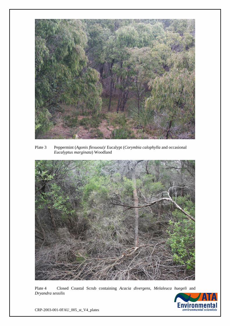
Plate 3 Peppermint (Agonis flexuosa)/ Eucalypt (Corymbia calophylla and occasional
Eucalyptus marginata) Woodland
Plate 4 Closed Coastal Scrub containing Acacia divergens, Melaleuca huegeli and Dryandra sessilis
CRP-2003-001-0FAU_005_st_V4_plates
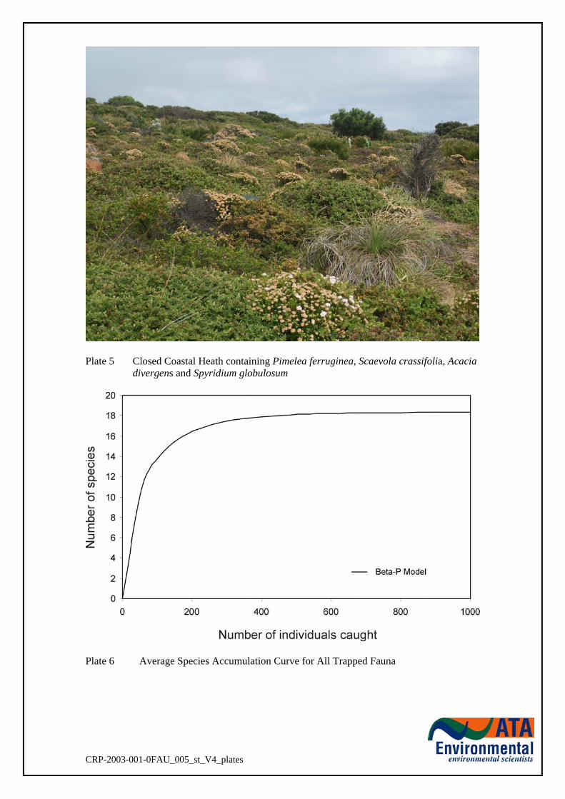
Plate 5 Closed Coastal Heath containing Pimelea ferruginea, Scaevola crassifolia, Acacia
divergens and Spyridium globulosum
Plate 6 Average Species Accumulation Curve for All Trapped Fauna
CRP-2003-001-0FAU_005_st_V4_plates
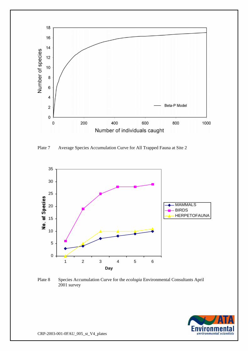
Plate 7 Average Species Accumulation Curve for All Trapped Fauna at Site 2 Plate 8 Species Accumulation Curve for the ecologia Environmental Consultants April
2001 survey
CRP-2003-001-0FAU_005_st_V4_plates
0
5
10
15
20
25
30
35
1 2 3 4 5 6Day
MAMMALSBIRDSHERPETOFAUNA

FIGURES

Dunsborough
BUSSELTON
0 10
FIGURE 1
0 20
Mon
11
Sep
06
PR
INT
ED
:
environmental scientistsEnvironmental
ATA
kilometres
Cape Mentelle
Cape Freycinet
AugustaFlinders Bay
HIGHWAY
Cav
es
Roa
d
Cowaramup
BlackwoodRiver
MargaretRiver
VASSE
LOCALITY MAP
PERTH
Kalgoorlie
Port Hedland
Geraldton
WESTERNAUSTRALIA
MargaretRiver
Cape Naturaliste
Sue
s
Geographe Bay
CapeLeeuwin
5 15
CapeHamelin
Hamelin Bay
Cape Clairault
INDIAN OCEAN
Road
ELL
WAY
HIGH
CowaramupBay
HardyInlet
REGIONAL LOCATION
HIG
HW
AY
Cav
es
BU
SS
Margaret River
Karridale
MANBROCKadR
o
Witchcliffe
Shire ofShire ofCapelCapel
Shire of BusseltonShire of Busselton
Shire ofShire ofAugusta-Augusta-
Margaret RiverMargaret River
Shire of NannupShire of Nannup
Subject LandYallingupYallingup
CR
P-2
003-
001/
26_5
0f1.
dgn
D
AT
UM
: MG
A
D
RA
WN
: TE
23-
2-06
C
HE
CK
ED
: BW
23-
2-06
SCALE 1 : 400 000 @ A4
VERTEBRATE FAUNA ASSESSMENTSMITHS BEACH, YALLINGUP
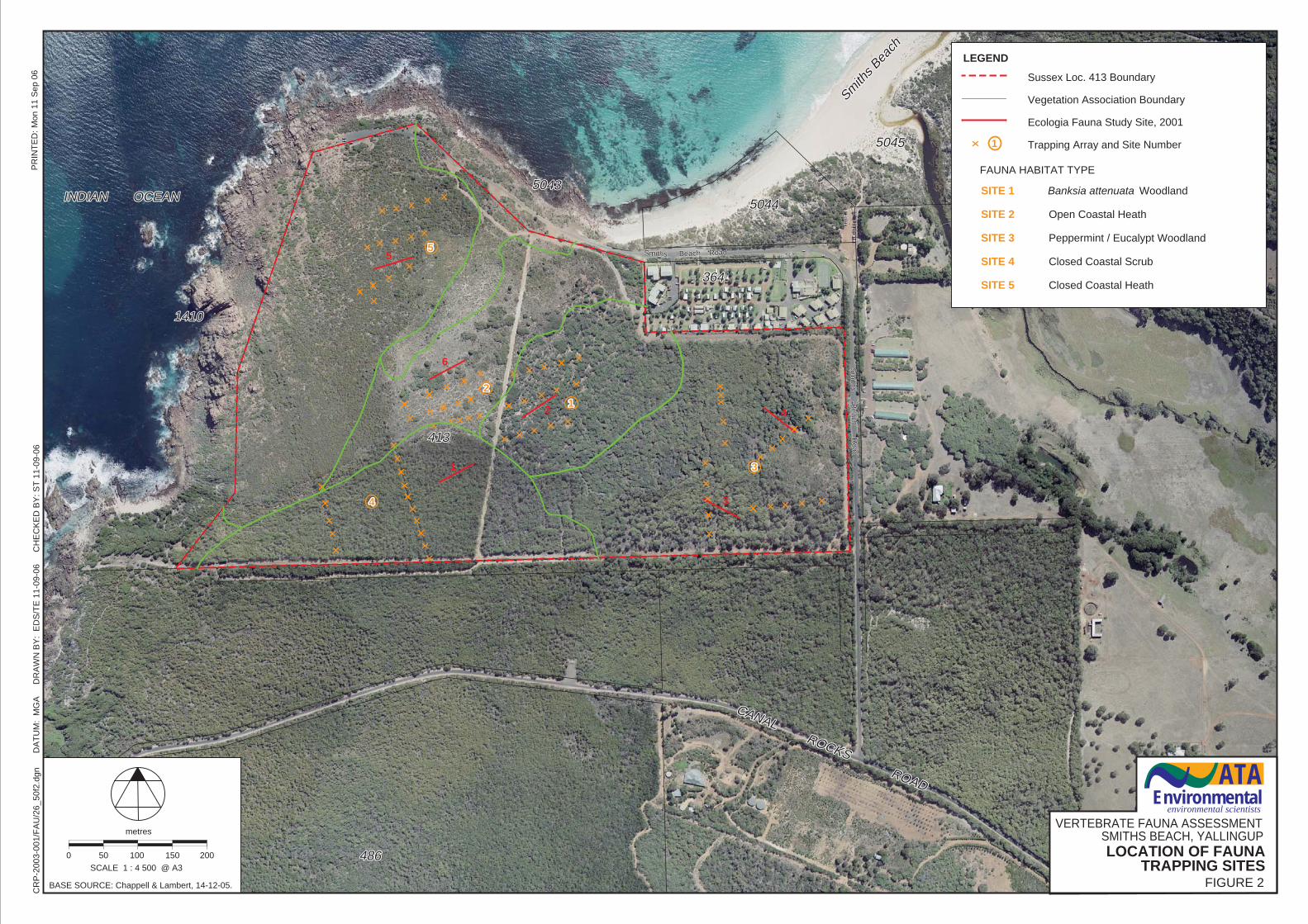
Smith
s Bea
ch
Smith
s Bea
ch
50455045
50445044
364364
50435043
413413
14101410
INDIAN OCEANINDIAN OCEAN
486486
ROADROAD
1
2
3
4
5
6
CR
P-2
003-
001/
FA
U/2
6_50
f2.d
gn
D
AT
UM
: M
GA
D
RA
WN
BY
: E
DS
/TE
11-
09-0
6
CH
EC
KE
D B
Y: S
T 1
1-09
-06
LEGEND
33
1122
55
44
Beach RoadBeach RoadSmithsSmiths
Sm
iths Beach R
oadS
miths B
each Road
CANAL ROCKS
CANAL ROCKS
Mon
11
Sep
06
PR
INT
ED
:
BASE SOURCE: Chappell & Lambert, 14-12-05.
11
Sussex Loc. 413 Boundary Vegetation Association Boundary Ecologia Fauna Study Site, 2001 Trapping Array and Site Number
0 50
metres
200100 150
SCALE 1 : 4 500 @ A3
environmental scientistsEnvironmental
ATA
VERTEBRATE FAUNA ASSESSMENTSMITHS BEACH, YALLINGUPLOCATION OF FAUNA
TRAPPING SITESFIGURE 2
SITE 1 Banksia attenuata Woodland SITE 2 Open Coastal Heath SITE 3 Peppermint / Eucalypt Woodland SITE 4 Closed Coastal Scrub SITE 5 Closed Coastal Heath
FAUNA HABITAT TYPE
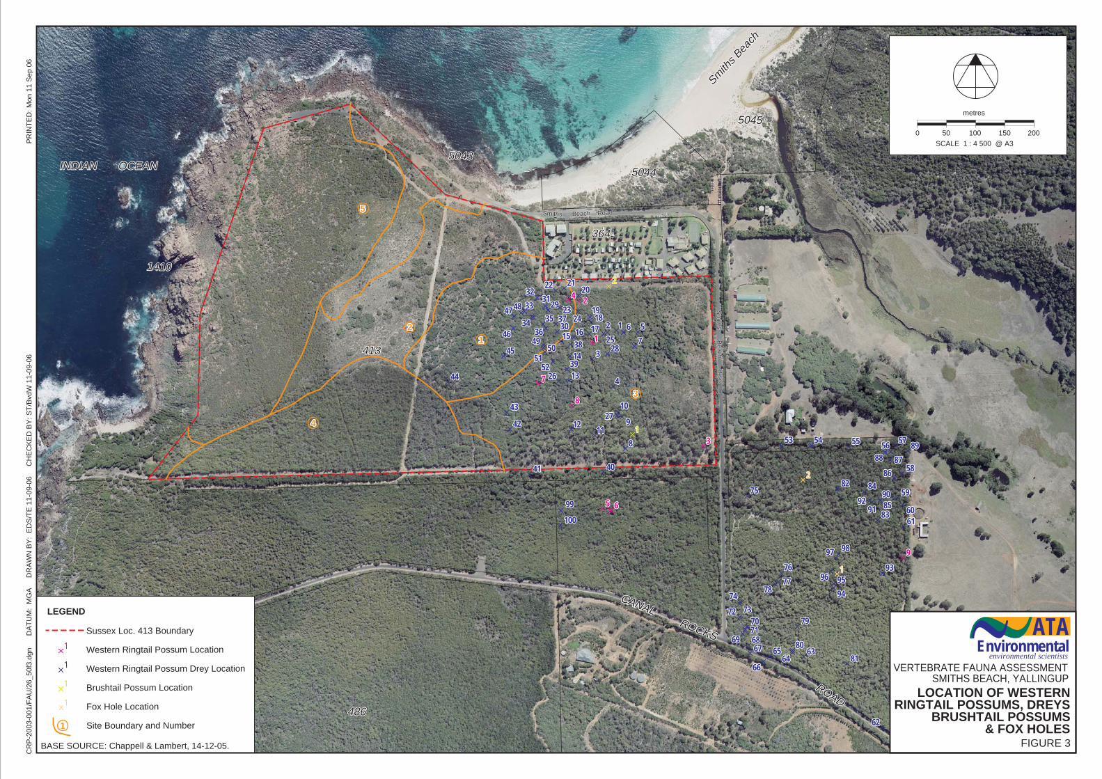
Smith
s Bea
ch
Smith
s Bea
ch
50455045
50445044
364364
50435043
413413
14101410
INDIAN OCEANINDIAN OCEAN
486486
ROAD
ROAD
Beach RoadBeach RoadSmithsSmiths
Sm
iths Beach R
oadS
miths B
each Road
CANAL ROCKS
CANAL ROCKS
BASE SOURCE: Chappell & Lambert, 14-12-05.
Mon
11
Sep
06
PR
INT
ED
:
FIGURE 3
VERTEBRATE FAUNA ASSESSMENTSMITHS BEACH, YALLINGUP
environmental scientistsEnvironmental
ATA
LOCATION OF WESTERNRINGTAIL POSSUMS, DREYS
BRUSHTAIL POSSUMS& FOX HOLES
LEGEND
11
11
11
11
0 50
metres
200100 150
SCALE 1 : 4 500 @ A3
555
44
2211
33
11
Sussex Loc. 413 Boundary Western Ringtail Possum Location Western Ringtail Possum Drey Location Brushtail Possum Location Fox Hole Location Site Boundary and Number
CR
P-2
003-
001/
FA
U/2
6_50
f3.d
gn
D
AT
UM
: M
GA
D
RA
WN
BY
: E
DS
/TE
11-
09-0
6
CH
EC
KE
D B
Y: S
T/B
vdW
11-
09-0
6
1122
33
44
5566
77
88
99
1010
11111212
1313
1414
1515 1616 17171818
1919
202021212222
23232424
2525
2626
2727
2828
2929
3030
31313232
3333
3434 3535
3636
3737
3838
3939
40404141
4242
4343
4444
4545
4646
47474848
49495050
51515252
5353 5454 5555 5656 5757
5858
5959
60606161
6262
63636464
6565
6666
676768686969
70707171
7272 7373
7474
7575
7676
77777878
7979
8080
8181
8282
8383
8484
8585
8686
878788888989
9090
91919292
9393
9494
95959696
9797 9898
9999
100100
11
22
11
22
11
22
33
44
55 66
77
88
99
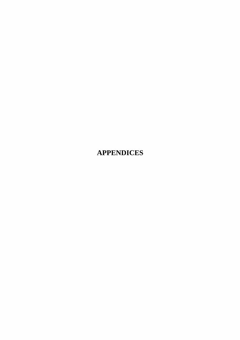
APPENDICES
APPENDIX 1
DETAILS OF VOUCHERED SPECIMENS FOR WESTERN AUSTRALIAN MUSEUM
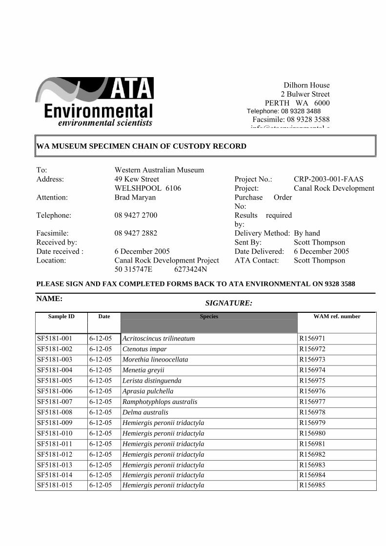
WA MUSEUM SPECIMEN CHAIN OF CUSTODY RECORD
To: Western Australian Museum Address: 49 Kew Street Project No.: CRP-2003-001-FAAS WELSHPOOL 6106 Project: Canal Rock DevelopmentAttention: Brad Maryan Purchase Order
No: Telephone: 08 9427 2700 Results required
by: Facsimile: 08 9427 2882 Delivery Method: By hand Received by: Sent By: Scott Thompson Date received : 6 December 2005 Date Delivered: 6 December 2005 Location: Canal Rock Development Project ATA Contact: Scott Thompson 50 315747E 6273424N
PLEASE SIGN AND FAX COMPLETED FORMS BACK TO ATA ENVIRONMENTAL ON 9328 3588
NAME: SIGNATURE:
Sample ID Date Species WAM ref. number
SF5181-001 6-12-05 Acritoscincus trilineatum R156971 SF5181-002 6-12-05 Ctenotus impar R156972 SF5181-003 6-12-05 Morethia lineoocellata R156973 SF5181-004 6-12-05 Menetia greyii R156974 SF5181-005 6-12-05 Lerista distinguenda R156975 SF5181-006 6-12-05 Aprasia pulchella R156976 SF5181-007 6-12-05 Ramphotyphlops australis R156977 SF5181-008 6-12-05 Delma australis R156978 SF5181-009 6-12-05 Hemiergis peronii tridactyla R156979 SF5181-010 6-12-05 Hemiergis peronii tridactyla R156980 SF5181-011 6-12-05 Hemiergis peronii tridactyla R156981 SF5181-012 6-12-05 Hemiergis peronii tridactyla R156982 SF5181-013 6-12-05 Hemiergis peronii tridactyla R156983 SF5181-014 6-12-05 Hemiergis peronii tridactyla R156984 SF5181-015 6-12-05 Hemiergis peronii tridactyla R156985
Dilhorn House 2 Bulwer Street
PERTH WA 6000 Telephone: 08 9328 3488
Facsimile: 08 9328 3588 info@ataenvironmental c
APPENDIX 2
SPECIES CAUGHT AND POTENTIALLY OCCURRING WITHIN THE PROJECT AREAS
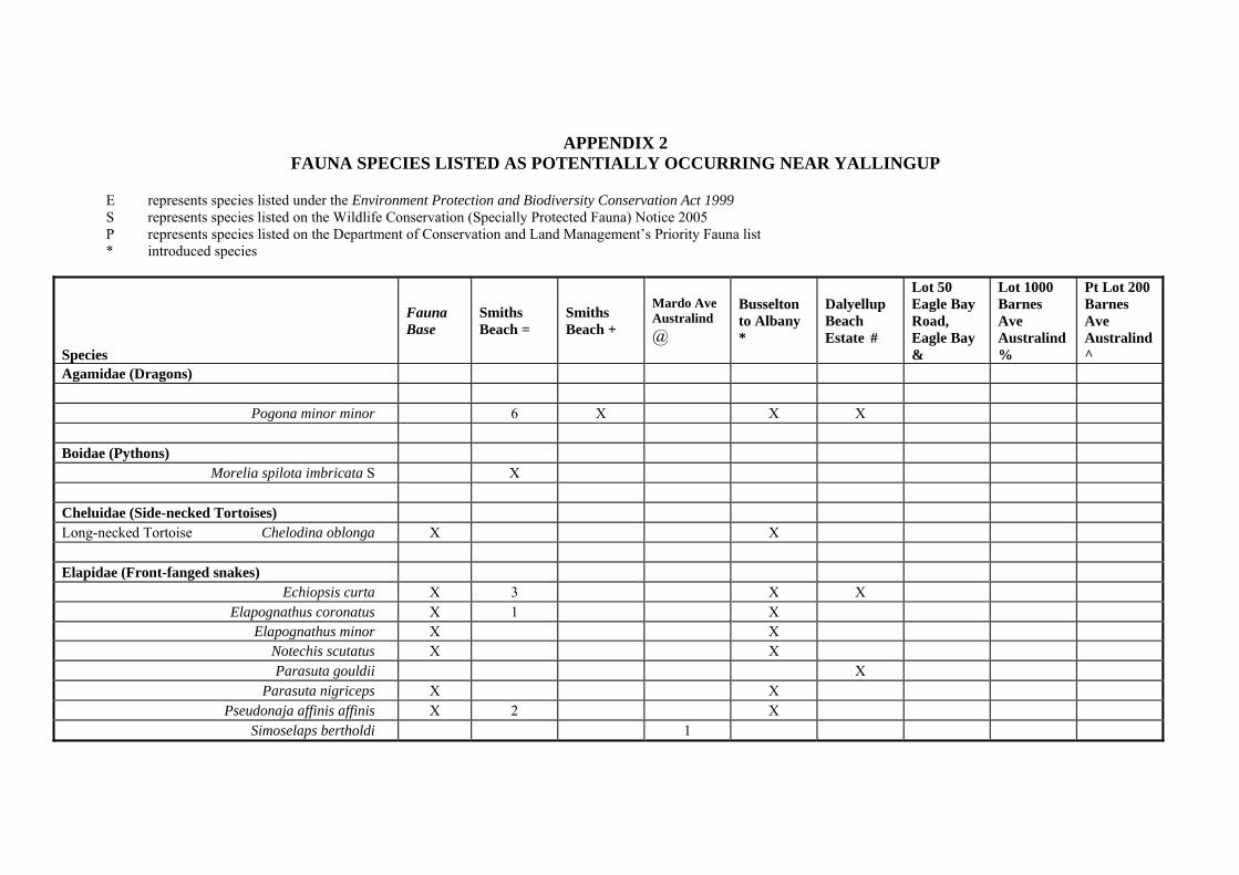
APPENDIX 2 FAUNA SPECIES LISTED AS POTENTIALLY OCCURRING NEAR YALLINGUP
E represents species listed under the Environment Protection and Biodiversity Conservation Act 1999 S represents species listed on the Wildlife Conservation (Specially Protected Fauna) Notice 2005 P represents species listed on the Department of Conservation and Land Management’s Priority Fauna list * introduced species
Species
Fauna Base
Smiths Beach =
Smiths Beach +
Mardo Ave Australind @
Busselton to Albany *
Dalyellup Beach Estate #
Lot 50 Eagle Bay Road, Eagle Bay &
Lot 1000 Barnes Ave Australind %
Pt Lot 200 Barnes Ave Australind ^
Agamidae (Dragons) Pogona minor minor 6 X X X Boidae (Pythons) Morelia spilota imbricata S X Cheluidae (Side-necked Tortoises) Long-necked Tortoise Chelodina oblonga X X Elapidae (Front-fanged snakes) Echiopsis curta X 3 X X Elapognathus coronatus X 1 X Elapognathus minor X X Notechis scutatus X X Parasuta gouldii X Parasuta nigriceps X X Pseudonaja affinis affinis X 2 X Simoselaps bertholdi 1
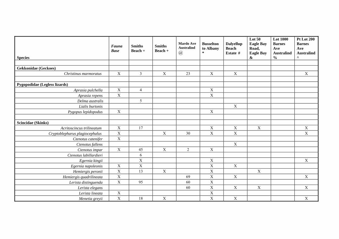
Species
Fauna Base
Smiths Beach =
Smiths Beach +
Mardo Ave Australind @
Busselton to Albany *
Dalyellup Beach Estate #
Lot 50 Eagle Bay Road, Eagle Bay &
Lot 1000 Barnes Ave Australind %
Pt Lot 200 Barnes Ave Australind ^
Gekkonidae (Geckoes) Christinus marmoratus X 3 X 23 X X X Pygopodidae (Legless lizards) Aprasia pulchella X 4 X Apra repens sia X X
Delma australis 5 Lialis burtonis X Pygopus lepidopodus X X Scincidae (Skinks) Acritoscincus trilineatum X 17 X X X X Cryptoblepharus plagiocephalus X X 30 X X X Ctenotus catenifer X Ctenotus fallens X Ctenotus impar X 45 X 2 X Ctenotus labillardieri 6 Egernia kingii X X X Egernia napoleonis X X X X Hemiergi peronii s X 13 X X X Hemiergis quadrilineata X 69 X X X Lerista distinguenda X 95 60 X Lerista elegans 60 X X X X Lerista lineata X X Menetia greyii X 18 X X X X
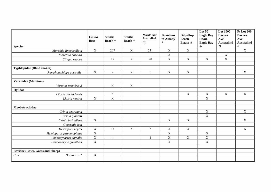
Species
Fauna Base
Smiths Beach =
Smiths Beach +
Mardo Ave Australind @
Busselton to Albany *
Dalyellup Beach Estate #
Lot 50 Eagle Bay Road, Eagle Bay &
Lot 1000 Barnes Ave Australind %
Pt Lot 200 Barnes Ave Australind ^
Morethia lineoocellata X 207 X 231 X X X Morethia obscura X X Tiliqua rugosa 89 X 20 X X X X Typhlopidae (Blind snakes) Ramphotyphlops austra lis X 2 X 5 X X X Varanidae (Monitors) Varanus rosenbergi X X Hylidae Litoria adelaidensis X X X X X Litori moorei a X X X Myobatrachidae Crinia georgiana X X Crinia glauerti X Crinia insignifera X X X X Geocrinia leai Heleioporu eyrei s X 13 X 3 X X X Heleioporus psammophilus X X X Limnodynastes dorsalis X 4 1 X X X Pseudophryne guentheri X X X Bovidae (Cows, Goats and Sheep) Cow Bos taurus * X
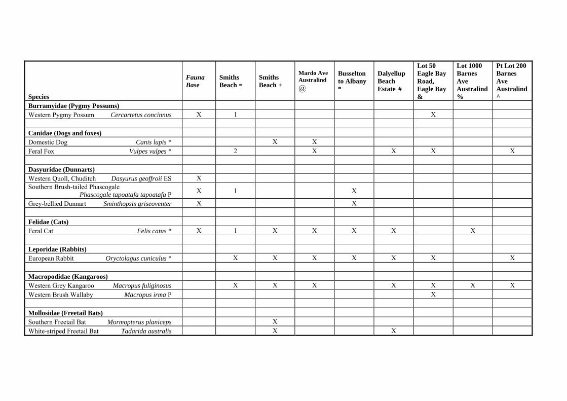
Species
Fauna Base
Smiths Beach =
Smiths Beach +
Mardo Ave Australind @
Busselton to Albany *
Dalyellup Beach Estate #
Lot 50 Eagle Bay Road, Eagle Bay &
Lot 1000 Barnes Ave Australind %
Pt Lot 200 Barnes Ave Australind ^
Burramyidae (Pygmy Possums) Western Pygmy Possum Cercartetus concinnus X 1 X Canidae (Dogs and foxes) Domestic Dog Canis lupis * X X Feral Fox Vulpes vulpes * 2 X X X X Dasyuridae (Dunnarts) Western Quoll, Chuditch Dasyurus geoffroii ES X Southern Brush-tailed Phascogale Phascogale tapoatafa tapoatafa P X 1 X
Grey-bellied Dunnart Sminthopsis griseoventer X X Felidae (Cats) Feral Cat Felis catus * X 1 X X X X X Leporidae (Rabbits) European Rabbit Oryctolagus cuniculus * X X X X X X X Macropodidae (Kangaroos) Western Grey Kangaroo Macropus fuliginosus X X X X X X X Western Brush Wallaby Macropus irma P X Mollosidae (Freetail Bats) Southern Freetail Bat Mormopterus planiceps X White-striped Freetail Bat Tadarida australis X X
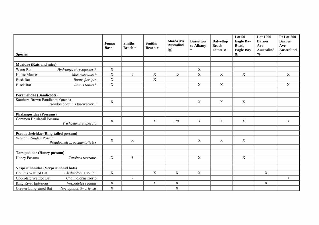
Species
Fauna Base
Smiths Beach =
Smiths Beach +
Mardo Ave Australind @
Busselton to Albany *
Dalyellup Beach Estate #
Lot 50 Eagle Bay Road, Eagle Bay &
Lot 1000 Barnes Ave Australind %
Pt Lot 200 Barnes Ave Australind ^
Muridae (Rats and mice) Water Rat Hydromys chrysogaster P X X House Mouse Mus musculus * X 5 X 15 X X X X Bush Rat Rattus fuscipes X X Black Rat Rattus rattus * X X X X Peramelidae (Bandicoots) Southern Brown Bandicoot, Quenda Isoodon obesulus fusciventer P X X X X
Phalangeridae (Possums) Common Brush-tail Possum Trichosurus vulpecula X X 29 X X X X
Pseudocheiridae (Ring-tailed possum) Western Ringtail Possum Pseudocheirus occidentalis ES X X X X X
Tarsipedidae (Honey possum) Honey Possum Tarsipes rostratus X 3 X X Vespertilionidae (Verpertilionid bats) Gould’s Wattled Bat Chalinolobus gouldii X X X X X Chocolate Wattled Bat Chalinolobus morio 2 X King River Eptesicus Vespadelus regulus X X X X Greater Long-eared Bat Nyctophilus timoriensis X X
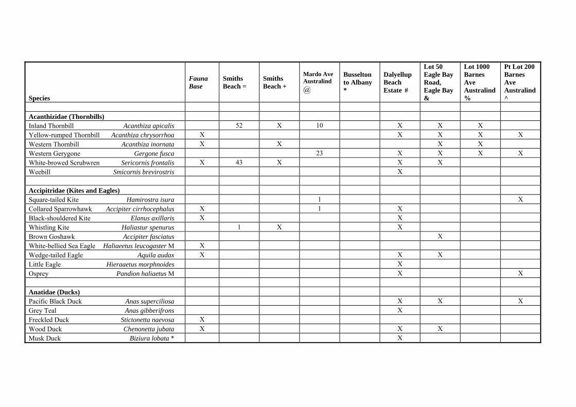
Species
Fauna Base
Smiths Beach =
Smiths Beach +
Mardo Ave Australind @
Busselton to Albany *
Dalyellup Beach Estate #
Lot 50 Eagle Bay Road, Eagle Bay &
Lot 1000 Barnes Ave Australind %
Pt Lot 200 Barnes Ave Australind ^
Acanthizidae (Thornbills) Inland Thornbill Acanthiza apicalis 52 X 10 X X X Yellow-rumped Thornbill Acanthiza chrysorrhoa X X X X X Western Thornbill Acanthiza inornata X X X X Western Gerygone Gergone fusca 23 X X X X White-browed Scrubwren Sericornis frontalis X 43 X X X Weebill Smicornis brevirostris X Accipitridae (Kites and Eagles) Square-tailed Kite Hamirostra isura 1 X Collared Sparrowhawk Accipiter cirrhocephalus X 1 X Black-shouldered Kite Elanus axillaris X X Whistling Kite Haliastur spenurus 1 X X Brown Goshawk Accipiter fasciatus X White-bellied Sea Eagle Haliaeetus leucogaster M X Wedge-tailed Eagle Aquila audax X X X Little Eagle Hieraaetus morphnoides X Osprey Pandion haliaetus M X X Anatidae (Ducks) Pacific Black Duck Anas superciliosa X X X Grey Teal Anas gibberifrons X Freckled Duck Stictonetta naevosa X Wood Duck Chenonetta jubata X X X Musk Duck Biziura lobata * X
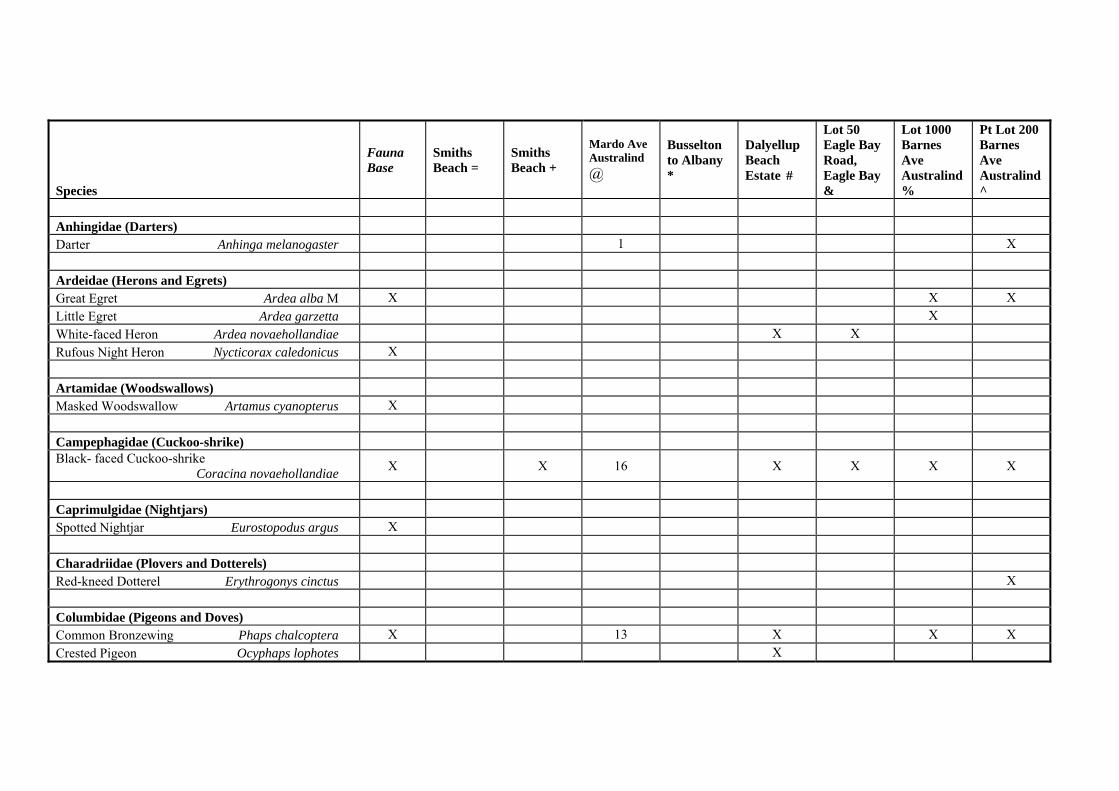
Species
Fauna Base
Smiths Beach =
Smiths Beach +
Mardo Ave Australind @
Busselton to Albany *
Dalyellup Beach Estate #
Lot 50 Eagle Bay Road, Eagle Bay &
Lot 1000 Barnes Ave Australind %
Pt Lot 200 Barnes Ave Australind ^
Anhingidae (Darters) Darter Anhinga melanogaster 1 X Ardeidae (Herons and Egrets) Great Egret Ardea alba M X X X Little Egret Ardea garzetta X White-faced Heron Ardea novaehollandiae X X Rufous Night Heron Nycticorax caledonicus X Artamidae (Woodswallows) Masked Woodswallow Artamus cyanopterus X Campephagidae (Cuckoo-shrike) Black- faced Cuckoo-shrike Coracina novaehollandiae X X 16 X X X X
Caprimulgidae (Nightjars) Spotted Nightjar Eurostopodus argus X Charadriidae (Plovers and Dotterels) Red-kneed Dotterel Erythrogonys cinctus X Columbidae (Pigeons and Doves) Common Bronzewing Phaps chalcoptera X 13 X X X Crested Pigeon Ocyphaps lophotes X

Species
Fauna Base
Smiths Beach =
Smiths Beach +
Mardo Ave Australind @
Busselton to Albany *
Dalyellup Beach Estate #
Lot 50 Eagle Bay Road, Eagle Bay &
Lot 1000 Barnes Ave Australind %
Pt Lot 200 Barnes Ave Australind ^
Brush Bronzewing Phaps elegans X 26 X Feral Pigeon Columbia livia* X Laughing Turtle-dove Streptopelia senegalensis * X Corvidae (Crows and Ravens) Australian Raven Corvus coronoides 59 X 33 X X X X Cracticidae (Butcherbirds and Magpies) Australian Magpie Cracticus tibicen X 58 X 34 X X X X Grey Butcherbird Cracticus torquatus X X 30 X X Pied Butcherbird Cracticus nigrogularis X 9 X Cuculidae (Cuckoos) Horsfield’s Bronze Cuckoo Chrysococcyx basalis X Shining Bronze Cuckoo Chrysococcyx lucidus X Fan-tailed Cuckoo Cuculus pyrrhophanus X Dicruridae (Flycatchers) Grey Fantail Rhipidura fuliginosa 43 X 25 X X X X Willy Wagtail Rhipidura leucophrys 39 X X Restless Flycatcher Myiagra inquieta X Magpie-lark Grallina cyanoleuca 1 X X Falconidae (Falcons) Australian Hobby Falco longipennis X X Brown Falcon Falco berigora 1
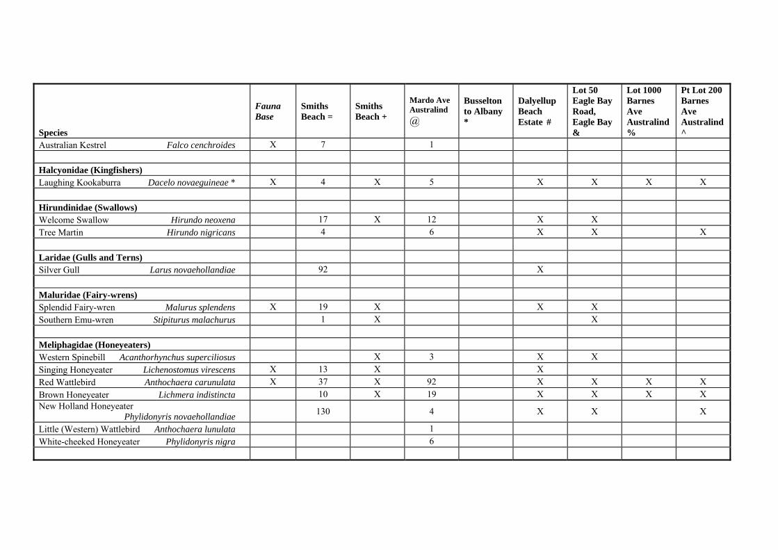
Species
Fauna Base
Smiths Beach =
Smiths Beach +
Mardo Ave Australind @
Busselton to Albany *
Dalyellup Beach Estate #
Lot 50 Eagle Bay Road, Eagle Bay &
Lot 1000 Barnes Ave Australind %
Pt Lot 200 Barnes Ave Australind ^
Australian Kestrel Falco cenchroides X 7 1 Halcyonidae (Kingfishers) Laughing Kookaburra Dacelo novaeguineae * X 4 X 5 X X X X Hirundinidae (Swallows) Welcome Swallow Hirundo neoxena 17 X 12 X X Tree Martin Hirundo nigricans 4 6 X X X Laridae (Gulls and Terns) Silver Gull Larus novaehollandiae 92 X Maluridae (Fairy-wrens) Splendid Fairy-wren Malurus splendens X 19 X X X Southern Emu-wren Stipiturus malachurus 1 X X Meliphagidae (Honeyeaters) Western Spinebill Acanthorhynchus superciliosus X 3 X X Singing Honeyeater Lichenostomus virescens X 13 X X Red Wattlebird Anthochaera carunulata X 37 X 92 X X X X Brown Honeyeater Lichmera indistincta 10 X 19 X X X X New Holland Honeyeater Phylidonyris novaehollandiae 130 4 X X X
Little (Western) Wattlebird Anthochaera lunulata 1 White-cheeked Honeyeater Phylidonyris nigra 6
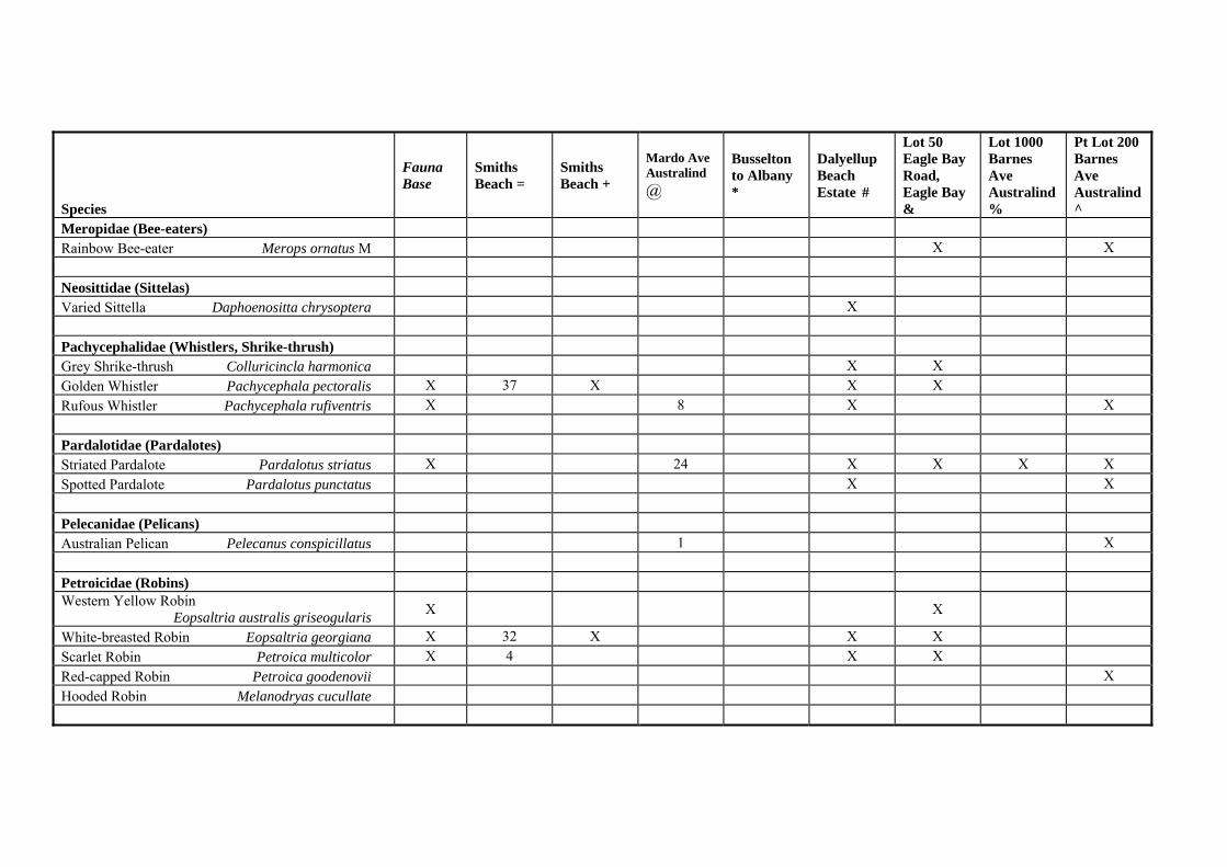
Species
Fauna Base
Smiths Beach =
Smiths Beach +
Mardo Ave Australind @
Busselton to Albany *
Dalyellup Beach Estate #
Lot 50 Eagle Bay Road, Eagle Bay &
Lot 1000 Barnes Ave Australind %
Pt Lot 200 Barnes Ave Australind ^
Meropidae (Bee-eaters) Rainbow Bee-eater Merops ornatus M X X Neosittidae (Sittelas) Varied Sittella Daphoenositta chrysoptera X Pachycephalidae (Whistlers, Shrike-thrush) Grey Shrike-thrush Colluricincla harmonica X X Golden Whistler Pachycephala pectoralis X 37 X X X Rufous Whistler Pachycephala rufiventris X 8 X X Pardalotidae (Pardalotes) Striated Pardalote Pardalotus striatus X 24 X X X X Spotted Pardalote Pardalotus punctatus X X Pelecanidae (Pelicans) Australian Pelican Pelecanus conspicillatus 1 X Petroicidae (Robins) Western Yellow Robin Eopsaltria australis griseogularis X X
White-breasted Robin Eopsaltria georgiana X 32 X X X Scarlet Robin Petroica multicolor X 4 X X Red-capped Robin Petroica goodenovii X Hooded Robin Melanodryas cucullate

Species
Fauna Base
Smiths Beach =
Smiths Beach +
Mardo Ave Australind @
Busselton to Albany *
Dalyellup Beach Estate #
Lot 50 Eagle Bay Road, Eagle Bay &
Lot 1000 Barnes Ave Australind %
Pt Lot 200 Barnes Ave Australind ^
Phalacrocoracidae (Cormorants) Little Pied Cormorant Phalacrocorax melanoleucos X X Little Black Cormorant Phalacrocorax sulcirostris X Pied Cormorant Phalacrocorax varius X X Podargidae (Frogmouths) Tawny Frogmouth Podargus strigoides X X X Podicipedidae (Grebes) Australasian Grebe Tachybaptus novaehollandiae X Hoary-headed Grebe Poliocephalus poliocephalus X Psittacidae (Parrots and lorikeets) Galah Cacatua roseicapilla 182 X 6 X Forest Red-tailed Black-Cockatoo Calyptorhynchus banksii naso S
X
Baudin’s Black-Cockatoo Calyptorhynchus baudinii ES X 63 X X
Carnaby’s Black-Cockatoo Calyptorhynchus latirostris ES X
Purple-crowned Lorikeet Glossopsitta porphyrocephala X 53
Elegant Parrot Neophema elegans 5 X X Western Rosella Platycercus icterotis X 2 X X Red-capped Parrot Platycercus spurious X X 34 X X X X Australian Ringneck Platycercus zonarius semitorquatus X 24 X 123 X X X X
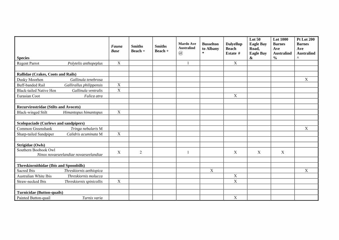
Species
Fauna Base
Smiths Beach =
Smiths Beach +
Mardo Ave Australind @
Busselton to Albany *
Dalyellup Beach Estate #
Lot 50 Eagle Bay Road, Eagle Bay &
Lot 1000 Barnes Ave Australind %
Pt Lot 200 Barnes Ave Australind ^
Regent Parrot Polytelis anthopeplus X 1 X Rallidae (Crakes, Coots and Rails) Dusky Moorhen Gallinula tenebrosa X Buff-banded Rail Gallirallus philippensis X Black-tailed Native Hen Gallinula ventralis X Eurasian Coot Fulica atra X Recurvirostridae (Stilts and Avocets) Black-winged Stilt Himantopus himantopus X Scolopaciade (Curlews and sandpipers) Common Greenshank Tringa nebularis M X Sharp-tailed Sandpiper Calidris acuminata M X Strigidae (Owls) Southern Boobook Owl Ninox novaeseelandiae novaeseelandiae X 2 1 X X X
Threskiornithidae (Ibis and Spoonbills) Sacred Ibis Threskiornis aethiopica X X Australian White Ibis Threskiornis molucca X Straw-necked Ibis Threskiornis spinicollis X X Turnicidae (Button-quails) Painted Button-quail Turnix varia X

Species
Fauna Base
Smiths Beach =
Smiths Beach +
Mardo Ave Australind @
Busselton to Albany *
Dalyellup Beach Estate #
Lot 50 Eagle Bay Road, Eagle Bay &
Lot 1000 Barnes Ave Australind %
Pt Lot 200 Barnes Ave Australind ^
Tytonidae (Owls) Barn Owl Tyto alba delicatula X Masked Owl X Tyto novaehollandiae novaehollandiae P
Zosteropidae (Silver-eyes) Silvereye Zosterops lateralis X 23 X 43 X X X X
X Indicates that the species was mentioned in species list but it was not identified how many specimens were recorded. = ATA Environmental (2006) Location 413 Smiths Beach Fauna Assessment Survey, Unpublished report for Canal Rocks Properties. @ ATA Environmental (2005) Lot 1001 Mardo Avenue, Australind, Environmental Assessment, Unpublished report for Marist Brothers, Report Number: 2005/56. * How, R.A., Dell, J. and Humphreys, W.F. (1987) The Ground Vertebrate Fauna of Coastal Areas between Busselton and Albany, Western Australia, Records
of the Western Australian Museum 13, 553-574. / Halpern Glick Maunsell (1994) Bunbury – Augusta Road Busselton Bypass Consultative Environmental Review, Report for Main Roads Western Australia. # ATA Environmental (1998) Vertebrate Fauna Dalyellup Beach Estate Shire of Capel, Unpublished report for Homeswest/Home Building Society and Satterley
Real Estate. & Harewood, G. (2005) Fauna Survey, Eagle Bay, Rural Residential Estate. Unpublished report to Cardno BSD. % ATA Environmental (2003) Lot 1000 Barnes Avenue, Australind Flora and Fauna Survey, Unpublished report for Marist Brothers, Report Number: 2003/24. ^ ecologia Environmental Consultants (2001) Part Lot 211 Barnes Avenue, Australind Fauna Assessment Survey, Unpublished report for Marist Brothers. + ecologia Environmental Consultants (2001) Location 413 Smiths Beach Fauna Assessment Survey, Unpublished report for ATA Environmental.