Embed Size (px)
Citation preview
KIN Mining NL ACN 150 597 541 342 Scarborough Beach Road, Osborne Park WA 6017
www.kinmining.com.au
ASX Code: KIN
Board of Directors
Terry Grammer
Chairman
Trevor Dixon
Managing Director
Fritz Fitton
Technical Director
Joe Graziano
Non-Executive Director &
Company Secretary
Contact Details
Post
PO Box 565
Mount Hawthorn
Western Australia 6915
Office
342 Scarborough Beach Road
Osborne Park
Western Australia 6017
Phone
08 9242 2227
Fax
08 9242 1277
Website
www.kinmining.com.au
Shares on Issue:
46,614,690 (KIN)
Options on Issue:
19,362,512 at $0.30
Expiring 31 January 2015
ASX: KIN
Page 1 of 11
Interpretation of IP Surveys
28 November 2014
High Priority Drill Targets Identified at Leonora Gold Project
Following Interpretation of IP Surveys at Perseverance and Kurrajong
Results demonstrate substantial exploration upside at the recently acquired Leonora Gold Project with
initial review of historical data revealing significant drill targets in close proximity to existing resources
Highlights
Perseverance
Several chargeable anomalies coincident with a resistive host rock identified from a
2013 IP survey, which successfully mapped the resistivity and chargeability distribution.
These anomalies may indicate the presence of disseminated pyrite and associated gold
mineralisation.
Excellent correlation with geological interpretation highlighting a sedimentary unit as a
priority exploration target which has previously undergone limited exploration.
Further follow-up targets identified displaying isolated high resistivity, with several
other chargeable anomalies also identified.
Kurrajong
Two strong chargeability, low resistivity anomalies identified along with numerous
isolated moderately chargeable, high resistivity features.
Kin Mining NL (ASX: KIN) is pleased to advise that it has identified numerous priority drill targets
at its recently acquired Leonora Gold Project (LGP) in WA from a review of existing data,
confirming the significant exploration upside and growth potential of the LGP outside of the
current extensive gold resource inventory.
Kin recently completed the acquisition of the LGP and has embarked on an aggressive
evaluation and development program, including conversion of the extensive JORC Mineral
Resource inventory to JORC 2012 compliance and a review of existing historical exploration
data.
The Company has recently completed an assessment and interpretation of the results of the
Induced Polarisation (IP) survey conducted by the previous owner, Navigator Resources, in
2013. This has resulted in the identification of multiple IP anomalies along both the
Perseverance and Kurrajong trends.
For
per
sona
l use
onl
y
Page 2 of 11
ASX Code: KIN
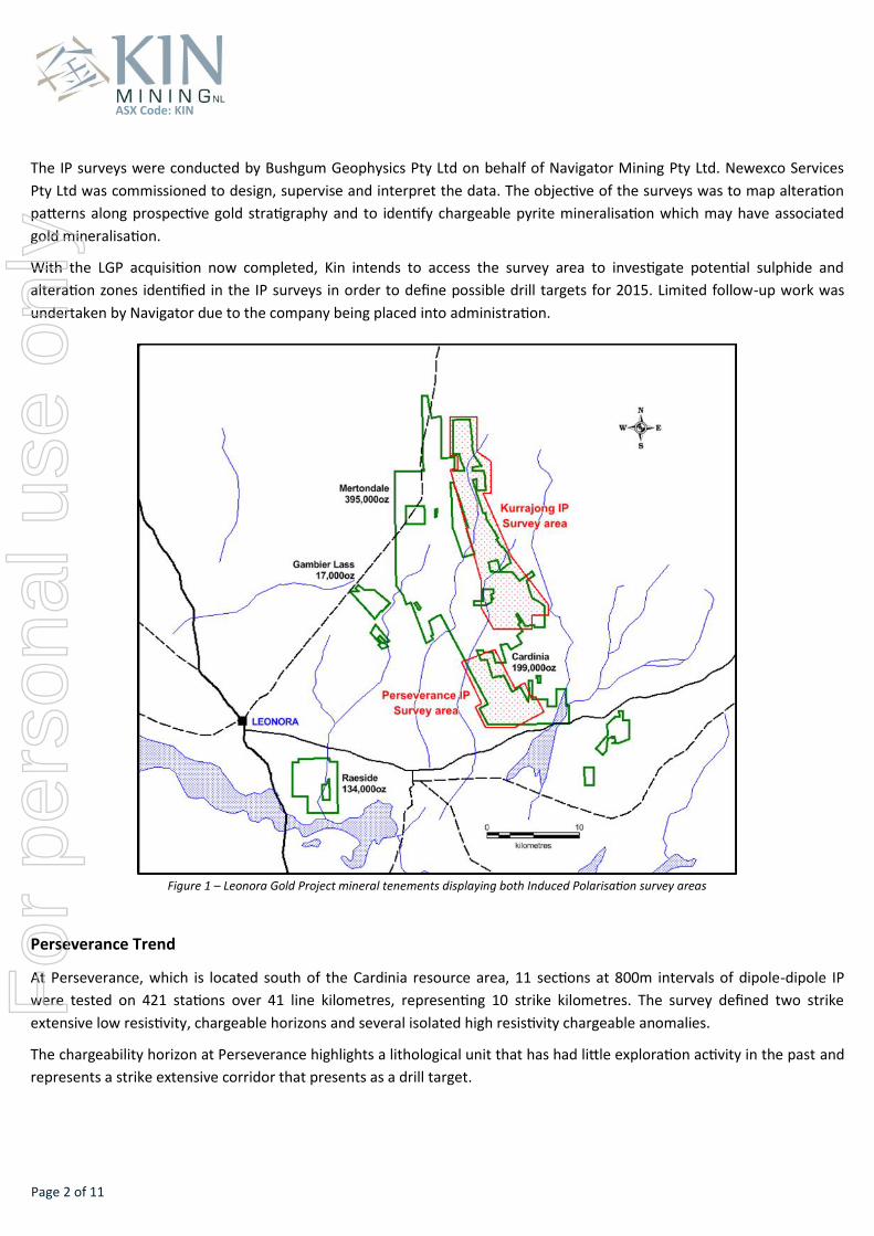
The IP surveys were conducted by Bushgum Geophysics Pty Ltd on behalf of Navigator Mining Pty Ltd. Newexco Services
Pty Ltd was commissioned to design, supervise and interpret the data. The objective of the surveys was to map alteration
patterns along prospective gold stratigraphy and to identify chargeable pyrite mineralisation which may have associated
gold mineralisation.
With the LGP acquisition now completed, Kin intends to access the survey area to investigate potential sulphide and
alteration zones identified in the IP surveys in order to define possible drill targets for 2015. Limited follow-up work was
undertaken by Navigator due to the company being placed into administration.
Perseverance Trend
At Perseverance, which is located south of the Cardinia resource area, 11 sections at 800m intervals of dipole-dipole IP
were tested on 421 stations over 41 line kilometres, representing 10 strike kilometres. The survey defined two strike
extensive low resistivity, chargeable horizons and several isolated high resistivity chargeable anomalies.
The chargeability horizon at Perseverance highlights a lithological unit that has had little exploration activity in the past and
represents a strike extensive corridor that presents as a drill target.
Figure 1 – Leonora Gold Project mineral tenements displaying both Induced Polarisation survey areas
For
per
sona
l use
onl
y
Page 3 of 11
ASX Code: KIN
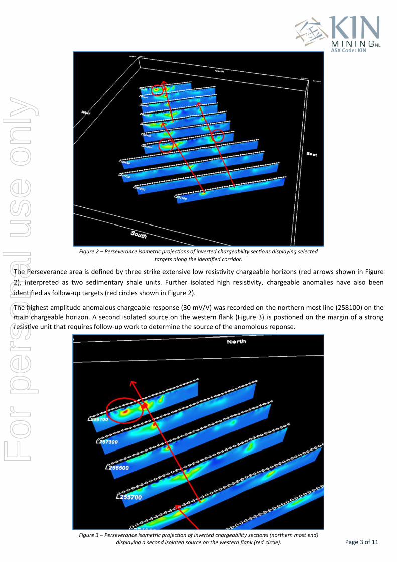
Figure 2 – Perseverance isometric projections of inverted chargeability sections displaying selected
targets along the identified corridor.
The Perseverance area is defined by three strike extensive low resistivity chargeable horizons (red arrows shown in Figure
2), interpreted as two sedimentary shale units. Further isolated high resistivity, chargeable anomalies have also been
identified as follow-up targets (red circles shown in Figure 2).
The highest amplitude anomalous chargeable response (30 mV/V) was recorded on the northern most line (258100) on the
main chargeable horizon. A second isolated source on the western flank (Figure 3) is postioned on the margin of a strong
resistive unit that requires follow-up work to determine the source of the anomolous reponse.
Figure 3 – Perseverance isometric projection of inverted chargeability sections (northern most end) displaying a second isolated source on the western flank (red circle).
For
per
sona
l use
onl
y
Page 4 of 11
ASX Code: KIN
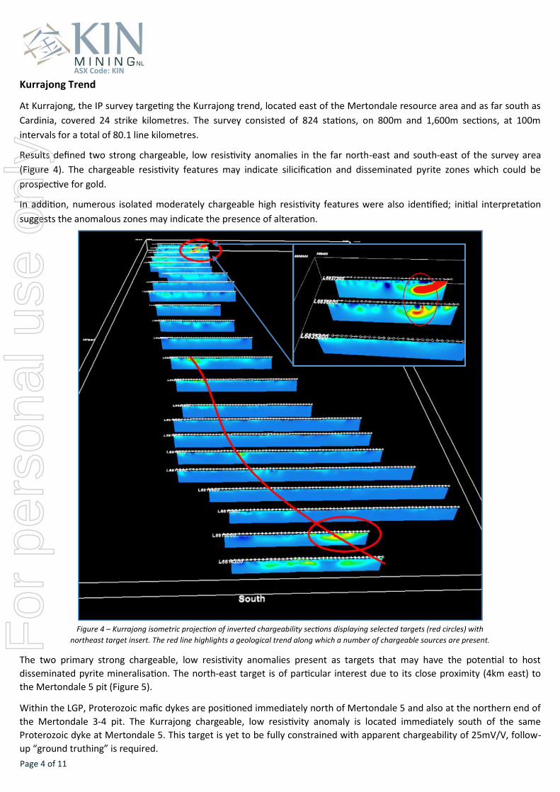
Figure 4 – Kurrajong isometric projection of inverted chargeability sections displaying selected targets (red circles) with
northeast target insert. The red line highlights a geological trend along which a number of chargeable sources are present.
Kurrajong Trend
At Kurrajong, the IP survey targeting the Kurrajong trend, located east of the Mertondale resource area and as far south as
Cardinia, covered 24 strike kilometres. The survey consisted of 824 stations, on 800m and 1,600m sections, at 100m
intervals for a total of 80.1 line kilometres.
Results defined two strong chargeable, low resistivity anomalies in the far north-east and south-east of the survey area
(Figure 4). The chargeable resistivity features may indicate silicification and disseminated pyrite zones which could be
prospective for gold.
In addition, numerous isolated moderately chargeable high resistivity features were also identified; initial interpretation
suggests the anomalous zones may indicate the presence of alteration.
The two primary strong chargeable, low resistivity anomalies present as targets that may have the potential to host
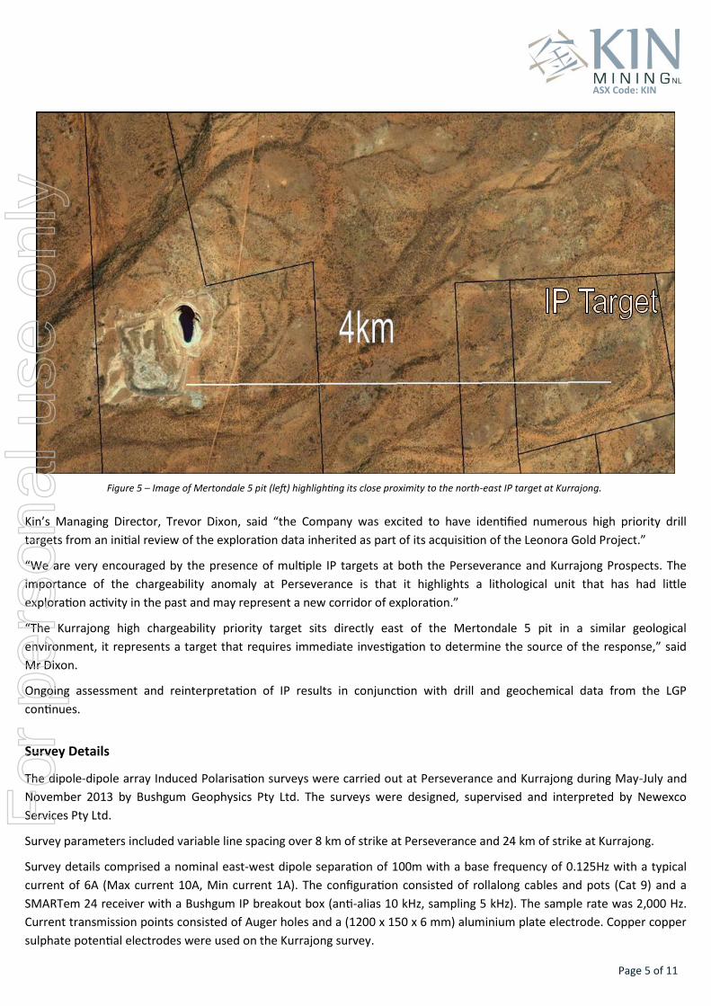
disseminated pyrite mineralisation. The north-east target is of particular interest due to its close proximity (4km east) to
the Mertondale 5 pit (Figure 5).
Within the LGP, Proterozoic mafic dykes are positioned immediately north of Mertondale 5 and also at the northern end of
the Mertondale 3-4 pit. The Kurrajong chargeable, low resistivity anomaly is located immediately south of the same
Proterozoic dyke at Mertondale 5. This target is yet to be fully constrained with apparent chargeability of 25mV/V, follow-
up “ground truthing” is required.
For
per
sona
l use
onl
y
Page 5 of 11
ASX Code: KIN
Figure 5 – Image of Mertondale 5 pit (left) highlighting its close proximity to the north-east IP target at Kurrajong.
Kin’s Managing Director, Trevor Dixon, said “the Company was excited to have identified numerous high priority drill
targets from an initial review of the exploration data inherited as part of its acquisition of the Leonora Gold Project.”
“We are very encouraged by the presence of multiple IP targets at both the Perseverance and Kurrajong Prospects. The
importance of the chargeability anomaly at Perseverance is that it highlights a lithological unit that has had little
exploration activity in the past and may represent a new corridor of exploration.”
“The Kurrajong high chargeability priority target sits directly east of the Mertondale 5 pit in a similar geological
environment, it represents a target that requires immediate investigation to determine the source of the response,” said
Mr Dixon.
Ongoing assessment and reinterpretation of IP results in conjunction with drill and geochemical data from the LGP
continues.
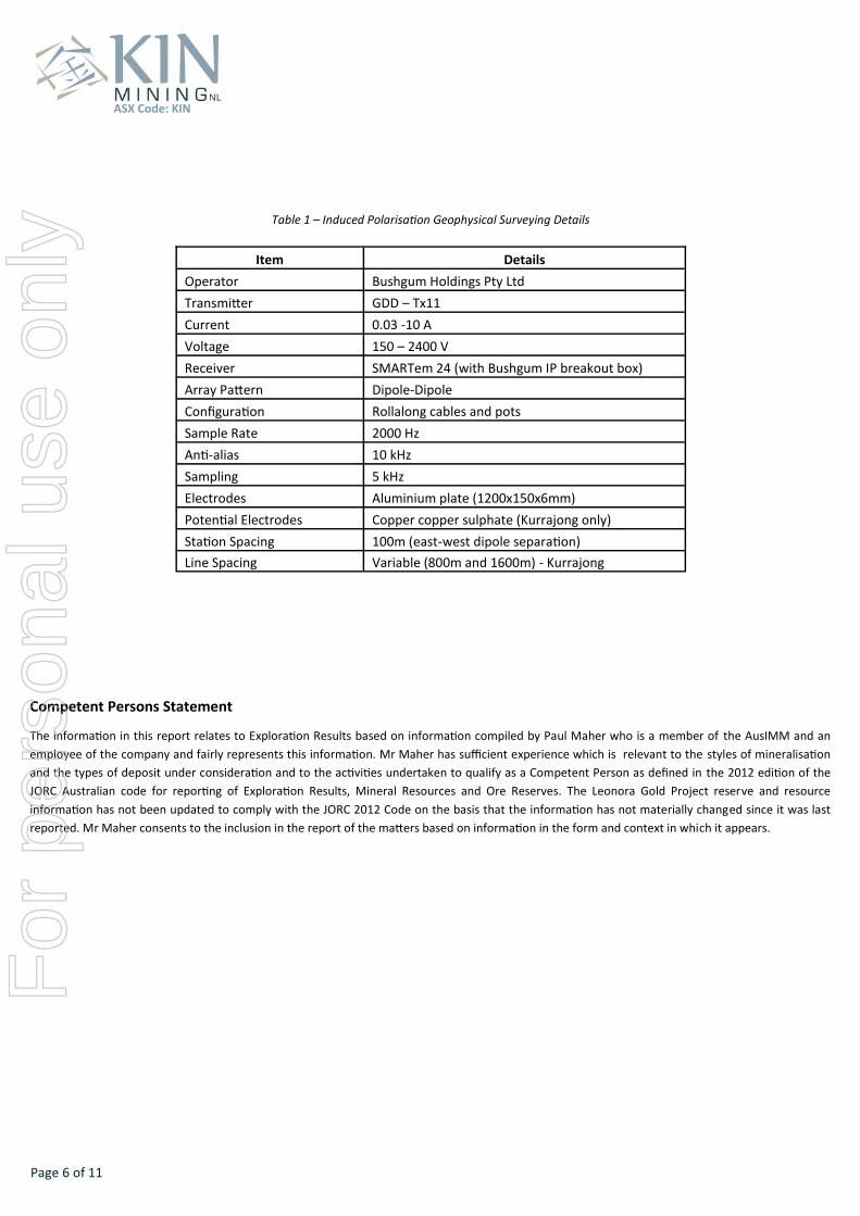
Survey Details
The dipole-dipole array Induced Polarisation surveys were carried out at Perseverance and Kurrajong during May-July and
November 2013 by Bushgum Geophysics Pty Ltd. The surveys were designed, supervised and interpreted by Newexco
Services Pty Ltd.
Survey parameters included variable line spacing over 8 km of strike at Perseverance and 24 km of strike at Kurrajong.
Survey details comprised a nominal east-west dipole separation of 100m with a base frequency of 0.125Hz with a typical
current of 6A (Max current 10A, Min current 1A). The configuration consisted of rollalong cables and pots (Cat 9) and a
SMARTem 24 receiver with a Bushgum IP breakout box (anti-alias 10 kHz, sampling 5 kHz). The sample rate was 2,000 Hz.
Current transmission points consisted of Auger holes and a (1200 x 150 x 6 mm) aluminium plate electrode. Copper copper
sulphate potential electrodes were used on the Kurrajong survey.
For
per
sona
l use
onl
y
Page 6 of 11
ASX Code: KIN
Table 1 – Induced Polarisation Geophysical Surveying Details
Item Details
Operator Bushgum Holdings Pty Ltd
Transmitter GDD – Tx11
Current 0.03 -10 A
Voltage 150 – 2400 V
Receiver SMARTem 24 (with Bushgum IP breakout box)
Array Pattern Dipole-Dipole
Configuration Rollalong cables and pots
Sample Rate 2000 Hz
Anti-alias 10 kHz
Sampling 5 kHz
Electrodes Aluminium plate (1200x150x6mm)
Potential Electrodes Copper copper sulphate (Kurrajong only)
Station Spacing 100m (east-west dipole separation)
Line Spacing Variable (800m and 1600m) - Kurrajong
Competent Persons Statement
The information in this report relates to Exploration Results based on information compiled by Paul Maher who is a member of the AusIMM and an
employee of the company and fairly represents this information. Mr Maher has sufficient experience which is relevant to the styles of mineralisation
and the types of deposit under consideration and to the activities undertaken to qualify as a Competent Person as defined in the 2012 edition of the
JORC Australian code for reporting of Exploration Results, Mineral Resources and Ore Reserves. The Leonora Gold Project reserve and resource
information has not been updated to comply with the JORC 2012 Code on the basis that the information has not materially changed since it was last
reported. Mr Maher consents to the inclusion in the report of the matters based on information in the form and context in which it appears.
For
per
sona
l use
onl
y
Page 7 of 11
ASX Code: KIN
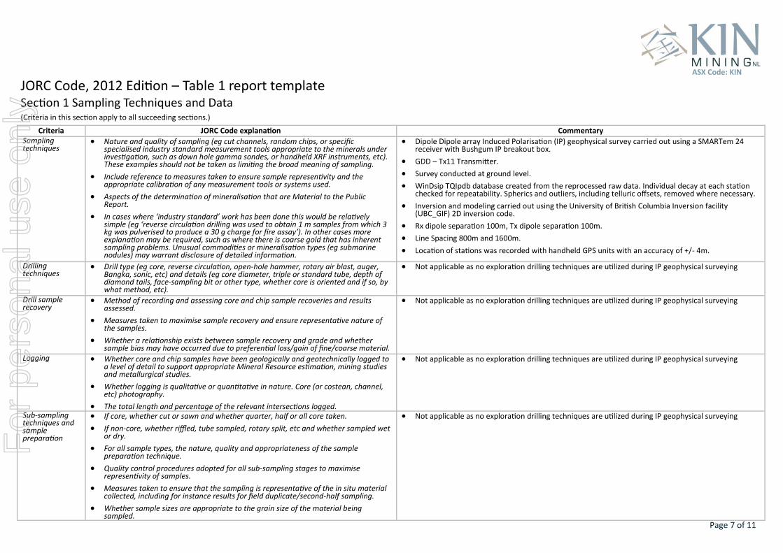
JORC Code, 2012 Edition – Table 1 report template Section 1 Sampling Techniques and Data (Criteria in this section apply to all succeeding sections.)
Criteria JORC Code explanation Commentary Sampling techniques
Nature and quality of sampling (eg cut channels, random chips, or specific specialised industry standard measurement tools appropriate to the minerals under investigation, such as down hole gamma sondes, or handheld XRF instruments, etc). These examples should not be taken as limiting the broad meaning of sampling.
Include reference to measures taken to ensure sample representivity and the appropriate calibration of any measurement tools or systems used.
Aspects of the determination of mineralisation that are Material to the Public Report.
In cases where ‘industry standard’ work has been done this would be relatively simple (eg ‘reverse circulation drilling was used to obtain 1 m samples from which 3 kg was pulverised to produce a 30 g charge for fire assay’). In other cases more explanation may be required, such as where there is coarse gold that has inherent sampling problems. Unusual commodities or mineralisation types (eg submarine nodules) may warrant disclosure of detailed information.
Dipole Dipole array Induced Polarisation (IP) geophysical survey carried out using a SMARTem 24 receiver with Bushgum IP breakout box.
GDD – Tx11 Transmitter.
Survey conducted at ground level.
WinDsip TQIpdb database created from the reprocessed raw data. Individual decay at each station checked for repeatability. Spherics and outliers, including telluric offsets, removed where necessary.
Inversion and modeling carried out using the University of British Columbia Inversion facility (UBC_GIF) 2D inversion code.
Rx dipole separation 100m, Tx dipole separation 100m.
Line Spacing 800m and 1600m.
Location of stations was recorded with handheld GPS units with an accuracy of +/- 4m.
Drilling techniques
Drill type (eg core, reverse circulation, open-hole hammer, rotary air blast, auger, Bangka, sonic, etc) and details (eg core diameter, triple or standard tube, depth of diamond tails, face-sampling bit or other type, whether core is oriented and if so, by what method, etc).
Not applicable as no exploration drilling techniques are utilized during IP geophysical surveying
Drill sample recovery
Method of recording and assessing core and chip sample recoveries and results assessed.
Measures taken to maximise sample recovery and ensure representative nature of the samples.
Whether a relationship exists between sample recovery and grade and whether sample bias may have occurred due to preferential loss/gain of fine/coarse material.
Not applicable as no exploration drilling techniques are utilized during IP geophysical surveying
Logging Whether core and chip samples have been geologically and geotechnically logged to a level of detail to support appropriate Mineral Resource estimation, mining studies and metallurgical studies.
Whether logging is qualitative or quantitative in nature. Core (or costean, channel, etc) photography.
The total length and percentage of the relevant intersections logged.
Not applicable as no exploration drilling techniques are utilized during IP geophysical surveying
Sub-sampling techniques and sample preparation
If core, whether cut or sawn and whether quarter, half or all core taken.
If non-core, whether riffled, tube sampled, rotary split, etc and whether sampled wet or dry.
For all sample types, the nature, quality and appropriateness of the sample preparation technique.
Quality control procedures adopted for all sub-sampling stages to maximise representivity of samples.
Measures taken to ensure that the sampling is representative of the in situ material collected, including for instance results for field duplicate/second-half sampling.
Whether sample sizes are appropriate to the grain size of the material being sampled.
Not applicable as no exploration drilling techniques are utilized during IP geophysical surveying
For
per
sona
l use
onl
y
Page 8 of 11
ASX Code: KIN
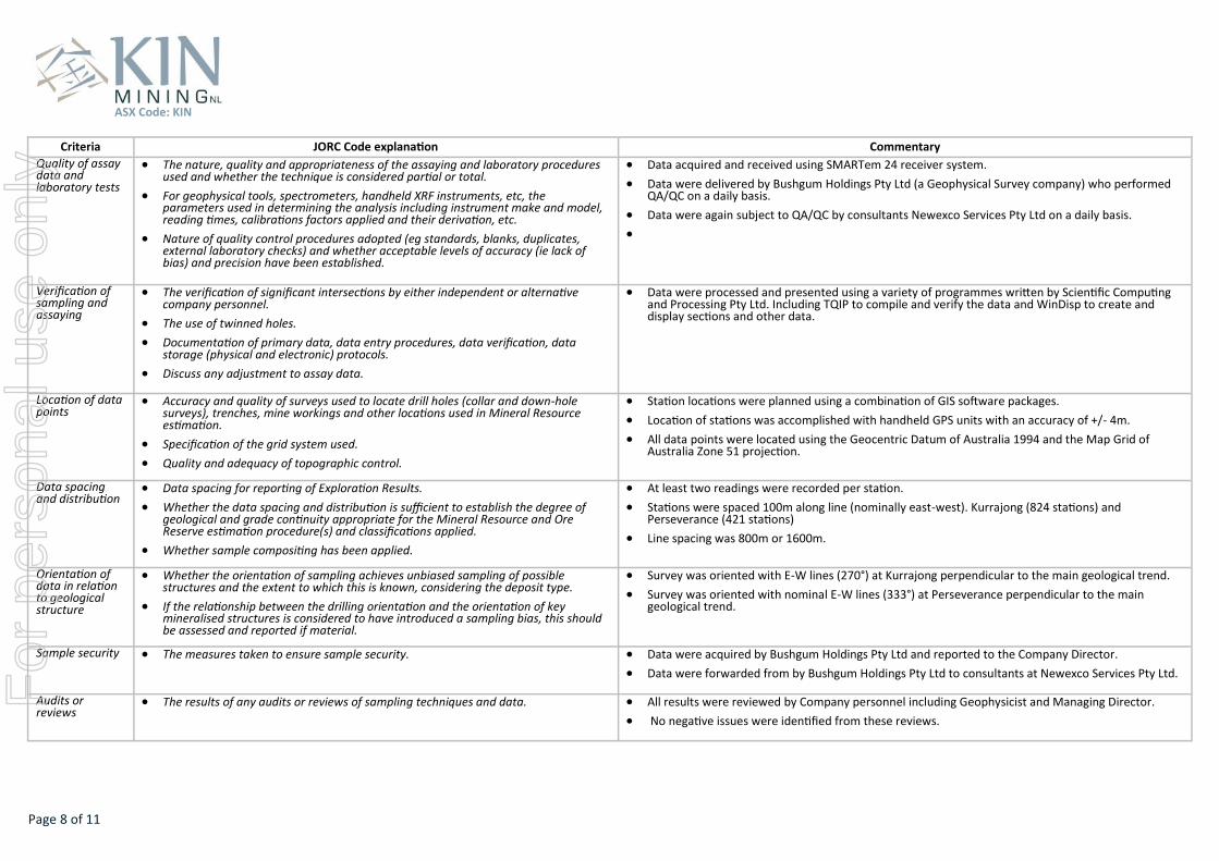
Criteria JORC Code explanation Commentary
Quality of assay data and laboratory tests
The nature, quality and appropriateness of the assaying and laboratory procedures used and whether the technique is considered partial or total.
For geophysical tools, spectrometers, handheld XRF instruments, etc, the parameters used in determining the analysis including instrument make and model, reading times, calibrations factors applied and their derivation, etc.
Nature of quality control procedures adopted (eg standards, blanks, duplicates, external laboratory checks) and whether acceptable levels of accuracy (ie lack of bias) and precision have been established.
Data acquired and received using SMARTem 24 receiver system.
Data were delivered by Bushgum Holdings Pty Ltd (a Geophysical Survey company) who performed QA/QC on a daily basis.
Data were again subject to QA/QC by consultants Newexco Services Pty Ltd on a daily basis.
Verification of sampling and assaying
The verification of significant intersections by either independent or alternative company personnel.
The use of twinned holes.
Documentation of primary data, data entry procedures, data verification, data storage (physical and electronic) protocols.
Discuss any adjustment to assay data.
Data were processed and presented using a variety of programmes written by Scientific Computing and Processing Pty Ltd. Including TQIP to compile and verify the data and WinDisp to create and display sections and other data.
Location of data points
Accuracy and quality of surveys used to locate drill holes (collar and down-hole surveys), trenches, mine workings and other locations used in Mineral Resource estimation.
Specification of the grid system used.
Quality and adequacy of topographic control.
Station locations were planned using a combination of GIS software packages.
Location of stations was accomplished with handheld GPS units with an accuracy of +/- 4m.
All data points were located using the Geocentric Datum of Australia 1994 and the Map Grid of Australia Zone 51 projection.
Data spacing and distribution
Data spacing for reporting of Exploration Results.
Whether the data spacing and distribution is sufficient to establish the degree of geological and grade continuity appropriate for the Mineral Resource and Ore Reserve estimation procedure(s) and classifications applied.
Whether sample compositing has been applied.
At least two readings were recorded per station.
Stations were spaced 100m along line (nominally east-west). Kurrajong (824 stations) and Perseverance (421 stations)
Line spacing was 800m or 1600m.
Orientation of data in relation to geological structure
Whether the orientation of sampling achieves unbiased sampling of possible structures and the extent to which this is known, considering the deposit type.
If the relationship between the drilling orientation and the orientation of key mineralised structures is considered to have introduced a sampling bias, this should be assessed and reported if material.
Survey was oriented with E-W lines (270°) at Kurrajong perpendicular to the main geological trend.
Survey was oriented with nominal E-W lines (333°) at Perseverance perpendicular to the main geological trend.
Sample security The measures taken to ensure sample security. Data were acquired by Bushgum Holdings Pty Ltd and reported to the Company Director.
Data were forwarded from by Bushgum Holdings Pty Ltd to consultants at Newexco Services Pty Ltd.
Audits or reviews
The results of any audits or reviews of sampling techniques and data. All results were reviewed by Company personnel including Geophysicist and Managing Director.
No negative issues were identified from these reviews.
For
per
sona
l use
onl
y
Page 9 of 11
ASX Code: KIN
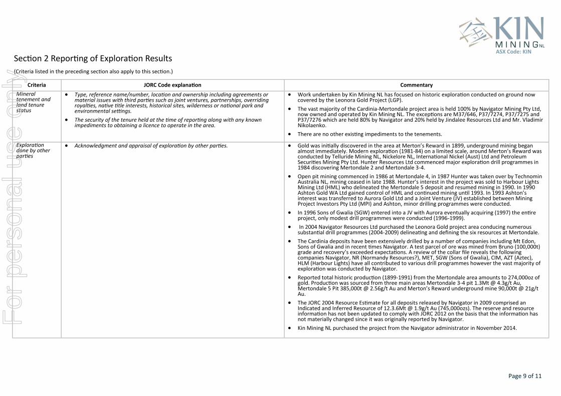
Section 2 Reporting of Exploration Results
(Criteria listed in the preceding section also apply to this section.)
Criteria JORC Code explanation Commentary
Mineral tenement and land tenure status
Type, reference name/number, location and ownership including agreements or material issues with third parties such as joint ventures, partnerships, overriding royalties, native title interests, historical sites, wilderness or national park and environmental settings.
The security of the tenure held at the time of reporting along with any known impediments to obtaining a licence to operate in the area.
Work undertaken by Kin Mining NL has focused on historic exploration conducted on ground now covered by the Leonora Gold Project (LGP).
The vast majority of the Cardinia-Mertondale project area is held 100% by Navigator Mining Pty Ltd, now owned and operated by Kin Mining NL. The exceptions are M37/646, P37/7274, P37/7275 and P37/7276 which are held 80% by Navigator and 20% held by Jindalee Resources Ltd and Mr. Vladimir Nikolaenko.
There are no other existing impediments to the tenements.
Exploration done by other parties
Acknowledgment and appraisal of exploration by other parties. Gold was initially discovered in the area at Merton’s Reward in 1899, underground mining began almost immediately. Modern exploration (1981-84) on a limited scale, around Merton’s Reward was conducted by Telluride Mining NL, Nickelore NL, International Nickel (Aust) Ltd and Petroleum Securities Mining Pty Ltd. Hunter Resources Ltd commenced major exploration drill programmes in 1984 discovering Mertondale 2 and Mertondale 3-4.
Open pit mining commenced in 1986 at Mertondale 4, in 1987 Hunter was taken over by Technomin Australia NL, mining ceased in late 1988. Hunter’s interest in the project was sold to Harbour Lights Mining Ltd (HML) who delineated the Mertondale 5 deposit and resumed mining in 1990. In 1990 Ashton Gold WA Ltd gained control of HML and continued mining until 1993. In 1993 Ashton’s interest was transferred to Aurora Gold Ltd and a Joint Venture (JV) established between Mining Project Investors Pty Ltd (MPI) and Ashton, minor drilling programmes were conducted.
In 1996 Sons of Gwalia (SGW) entered into a JV with Aurora eventually acquiring (1997) the entire project, only modest drill programmes were conducted (1996-1999).
In 2004 Navigator Resources Ltd purchased the Leonora Gold project area conducing numerous substantial drill programmes (2004-2009) delineating and defining the six resources at Mertondale.
The Cardinia deposits have been extensively drilled by a number of companies including Mt Edon, Sons of Gwalia and in recent times Navigator. A test parcel of ore was mined from Bruno (100,000t) grade and recovery’s exceeded expectations. A review of the collar file reveals the following companies Navigator, NR (Normandy Resources?), MET, SGW (Sons of Gwalia), CIM, AZT (Aztec), HLM (Harbour Lights) have all contributed to various drill programmes however the vast majority of exploration was conducted by Navigator.
Reported total historic production (1899-1991) from the Mertondale area amounts to 274,000oz of gold. Production was sourced from three main areas Mertondale 3-4 pit 1.3Mt @ 4.3g/t Au, Mertondale 5 Pit 385,000t @ 2.56g/t Au and Merton’s Reward underground mine 90,000t @ 21g/t Au.
The JORC 2004 Resource Estimate for all deposits released by Navigator in 2009 comprised an Indicated and Inferred Resource of 12.3.6Mt @ 1.9g/t Au (745,000ozs). The reserve and resource information has not been updated to comply with JORC 2012 on the basis that the information has not materially changed since it was originally reported by Navigator.
Kin Mining NL purchased the project from the Navigator administrator in November 2014.
For
per
sona
l use
onl
y
Page 10 of 11
ASX Code: KIN
Criteria JORC Code explanation Commentary
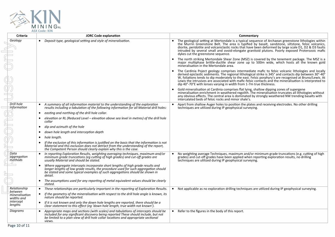
Geology Deposit type, geological setting and style of mineralisation. The geological setting at Mertondale is a typical sequence of Archaean greenstone lithologies within the Murrin Greenstone Belt. The area is typified by basalt, sandstone, siltstone, felsic volcanics, diorite, peridotite and volcaniclastic rocks that have been deformed by large scale D1, D2 & D3 faults intruded by several small and ovoid-elongate granitoid plutons. Poorly exposed Proterozoic mafic dykes cut the greenstone sequence.
The north striking Mertondale Shear Zone (MSZ) is covered by the tenement package. The MSZ is a major multiphase brittle-ductile shear zone up to 500m wide, which hosts all the known gold mineralisation in the Mertondale area.
The Cardinia Poject geology comprises intermediate mafic to felsic volcanic lithologies and locally derived epiclastic sediments. The regional lithological strike is 345° and contacts dip between 30°-40°W, foliations tends to dip moderately to the east. Felsic porphyry’s are recognised at Bruno/Lewis. At Lewis the intrusives are associated with mafic-felsic contacts and the mineralisation is interpreted to dip 40°-70°E with lenses varying in width from 1-7m true thickness.
Gold mineralisation at Cardinia comprises flat lying, shallow dipping zones of supergene mineralisation enrichment in weathered regolith. The mineralisation truncates all lithologies without any obvious effects. The central area is dominated by strongly weathered NW trending basalts with intercalated beds of felsic rocks and minor shale’s.
Drill hole Information
A summary of all information material to the understanding of the exploration results including a tabulation of the following information for all Material drill holes:
easting and northing of the drill hole collar.
elevation or RL (Reduced Level – elevation above sea level in metres) of the drill hole collar
dip and azimuth of the hole
down hole length and interception depth
hole length.
If the exclusion of this information is justified on the basis that the information is not Material and this exclusion does not detract from the understanding of the report, the Competent Person should clearly explain why this is the case.
Apart from shallow Auger holes to position the plates and receiving electrodes. No other drilling techniques are utilized during IP geophysical surveying.
Data aggregation methods
In reporting Exploration Results, weighting averaging techniques, maximum and/or minimum grade truncations (eg cutting of high grades) and cut-off grades are usually Material and should be stated.
Where aggregate intercepts incorporate short lengths of high grade results and longer lengths of low grade results, the procedure used for such aggregation should be stated and some typical examples of such aggregations should be shown in detail.
The assumptions used for any reporting of metal equivalent values should be clearly stated.
No weighting average Techniques, maximum and/or minimum grade truncations (e.g. cutting of high grades) and cut-off grades have been applied when reporting exploration results, no drilling techniques are utilized during IP geophysical surveying.
Relationship between mineralisation widths and intercept lengths
These relationships are particularly important in the reporting of Exploration Results.
If the geometry of the mineralisation with respect to the drill hole angle is known, its nature should be reported.
If it is not known and only the down hole lengths are reported, there should be a clear statement to this effect (eg ‘down hole length, true width not known’).
Not applicable as no exploration drilling techniques are utilized during IP geophysical surveying.
Diagrams Appropriate maps and sections (with scales) and tabulations of intercepts should be included for any significant discovery being reported These should include, but not be limited to a plan view of drill hole collar locations and appropriate sectional views.
Refer to the figures in the body of this report.
For
per
sona
l use
onl
y
Page 11 of 11
ASX Code: KIN
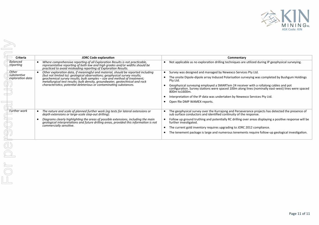
Criteria JORC Code explanation Commentary Balanced reporting
Where comprehensive reporting of all Exploration Results is not practicable, representative reporting of both low and high grades and/or widths should be practiced to avoid misleading reporting of Exploration Results.
Not applicable as no exploration drilling techniques are utilized during IP geophysical surveying.
Other substantive exploration data
Other exploration data, if meaningful and material, should be reported including (but not limited to): geological observations; geophysical survey results; geochemical survey results; bulk samples – size and method of treatment; metallurgical test results; bulk density, groundwater, geotechnical and rock characteristics; potential deleterious or contaminating substances.
Survey was designed and managed by Newexco Services Pty Ltd.
The onsite Dipole-dipole array Induced Polarisation surveying was completed by Bushgum Holdings Pty Ltd.
Geophysical surveying employed a SMARTem 24 receiver with a rollalong cables and pot configuration. Survey stations were spaced 100m along lines (nominally east-west) lines were spaced 800m to1600m.
Interpretation of the IP data was undertaken by Newexco Services Pty Ltd.
Open file DMP WAMEX reports.
Further work The nature and scale of planned further work (eg tests for lateral extensions or depth extensions or large-scale step-out drilling).
Diagrams clearly highlighting the areas of possible extensions, including the main geological interpretations and future drilling areas, provided this information is not commercially sensitive.
The geophysical survey over the Kurrajong and Perseverance projects has detected the presence of sub surface conductors and identified continuity of the response.
Follow up ground truthing and potentially RC drilling over areas displaying a positive response will be further investigated.
The current gold inventory requires upgrading to JORC 2012 compliance.
The tenement package is large and numerous tenements require follow-up geological investigation.
For
per
sona
l use
onl
y

![$= X &DSWDLQ E ^&^ / v À ] ] } v o µ P î î v t î ï · K o ] À ] D Ì Ì v } · î ï ^^ U î î ì î î ] v } ] · ò î U ^^ î ì î î : } v D D Z } v · ñ K µ ( ] o](https://img.pdfslide.us/doc/110x75/5fd89c25f3a0516e76322c26/-x-dswdlq-e-v-v-o-p-v-t-k-o-d-oe.jpg)


![} v } u ] Z À ] } ( } ] Ç · 2018. 11. 28. · s Z ' î ì í í î ì í î î ì í ï î ì í ð î ì í ñ î ì í ò z î ì í í î ì í î î ì í ï î ì í ð î](https://img.pdfslide.us/doc/110x75/601e1b37d8b1f16a0800f14a/-v-u-z-2018-11-28-s-z-.jpg)