Embed Size (px)
Citation preview

ASX Announcement and Media Release
5 May 2017
GOLD MINERALISATION EXTENSION LIKELY AT KALAMAZOO’S W.A.
GOLD PROJECT
Eight (8) holes completed of a planned 15 hole 2,000 metre program
Results1 received for first batch of Mixy drilling:
o 3 metres of 2.48 g/t Au from 87 metres in hole 17KZRC001
o 7 metres of 2.99 g/t Au from 70 metres in hole 17KZRC003
o 6 metres of 6.38 g/t Au from 52 metres in hole 17KZRC005
including 1 metre of 27.8 g/t Au from 52 metres
o 10 metres of 3.73 g/t Au from 68 metres in hole 17KZRC006
including 1 metre of 19.61 g/t Au from 69 metres
Gold mineralisation likely to extend 150 metres to the east of Mixy in oxide
zone and is open to depth
Results indicate that shallow historic drilling, in some cases vertical, may have
easily missed a Mixy style quartz lode
Results pending for four holes and three deeper holes to be completed
First Right agreed with Minjar Gold via an Ore Purchase Agreement for any
future Mixy and A-Zone gold ore processing
1 Refer to Table 1 Mixy RC Drilling - Significant Results
For
per
sona
l use
onl
y

Emerging gold-copper exploration company, Kalamazoo Resources Limited (ASX: KZR) (“Kalamazoo”), today announced a likely gold mineralisation extension at its flagship gold project in Western Australia.
Kalamazoo is progressing a 2,000 metre Reverse Circulation (RC) drilling program on the
Mixy project (“Mixy”), which forms part of its flagship Snake Well Gold Project (Figure 1),
located about 450km north of Perth in the Mid-West region.
This current drilling is part of an overall works program, outlined in Kalamazoo’s Prospectus2 aimed at testing extensions of the near surface and deeper gold mineralised zones at Mixy, the site of the successful Mixy trial pit completed in early 2016. The trial produced 4,459 ozs of gold as processed through the Minjar Gold Plant, under an Ore Tolling Agreement2. Results for the first eight RC drill holes designed to test for extensions of the Mixy quartz vein lode(s) over 250 metres to the east of the Mixy trial open pit, and at relatively shallow depths down to 60 vertical metres, from surface to oxidized material (Figures 2 to 5) have now been received.
Figure 1: Location of A-Zone and Mixy Project areas
Note: The tenement outline has since been modified to reflect two new tenement applications E59/2240 and
E59/2239 and one relinquished tenement, E59/2200, since the Prospectus was issued in October 2016.
2 Refer to the Independent Geologists Report in Section 5 of the KZR Prospectus, October 2016
For
per
sona
l use
onl
y

Figure 2: Mixy Project Drill Collar Location Plan and Cross Section Locations
The results are from one metre samples taken over a target interval in each hole. Significant results (>0.5 g/t Au, maximum of two metres of internal dilution included) are listed in Table 1. Sub-samples were analyzed by fire assay for gold, with further details provided in Table 2. Results are pending for composite samples - taken over four metres intervals - in the hanging wall and footwall to the main lode, in order, to test for possible parallel lodes. The results from holes 17KZRC003 to 17KZRC005 and 17KZRC006 (cross sections A-B and C-D, Figures 3 and 4 respectively) indicate that the main Mixy lode extends for a possible 150 metres east of the existing trial pit. Holes 17KZRC007 and 17KZRC008, a further 100 metres to the east, did not intersect significant mineralisation (Figure 5).
For
per
sona
l use
onl
y

Figure 3: Cross Section A-B Drill Results
(Intersections are down hole lengths of >0.5 g/t Au, and include a maximum of 2m at <0.5 g/t Au)
(Note: Selective historical drill hole intercepts, RASW187, 93RAWR137 and 94RWR246, refer to the
Independent Geologist’s Report in Section 5 of the Prospectus, October 2016.)
Of note, drill holes 17KZRC004 to 17KZRC006 intersected good gold mineralisation, despite historical drilling failing to indicate any mineralisation (Figure 3). This may be due to the vertical angle of some of the historical drilling or the style of drilling and, in some cases, open hole Rotary Air Blast (RAB) style which may not be an optimal method for testing very high grade, sub vertical and high nugget style gold zones, such as Mixy. Consequently, Kalamazoo plans to review the historical drilling results throughout the Snake Well Gold Project area to assess if past drilling may not have properly tested gold potential, particularly in oxidized zones. Results are pending for the next four holes (17KZRC009 to 17KZRC012), while three more holes remain to be drilled to complete this program. Once the full set of drilling results is available and interpreted, Kalamazoo will determine the next steps at the Mixy project. F
or p
erso
nal u
se o
nly

Figure 4: Cross Section C-D Drill Results
(Intersections are down hole lengths of >0.5 g/t Au, and include a maximum of 2m at <0.5 g/t Au)
For
per
sona
l use
onl
y

Figure 5: Mixy Longitudinal (looking north) First Batch Drilling Results and Location of Results Pending and
Remaining Holes to Be Drilled
Refer to Independent Geologist’s Report by Ravensgate in Section 5 of the Company’s Prospectus, October
2016
Kalamazoo Resources confirms that it is not aware of any new information or data that materially affects the information included in the previous market announcement/s referred to and in the case of exploration results and mineral resources, that all material assumptions and technical parameters underpinning the estimates continue to apply and have not materially changed.
For
per
sona
l use
onl
y

New Ore Purchase Agreement for Treatment of Mixy and A-Zone Ore via Minjar Gold Plant In May 2013 - prior to its ASX listing - Kalamazoo undertook a conceptual mining study of the Mixy Lode to gather information regarding the optimum way to accurately estimate gold grade. The positive result from this study enabled Kalamazoo to sign a Mining Agreement with a third party to mine approximately 4,400 ounces of near-surface ore from the Mixy Lode. An Ore Processing Agreement (Agreement) was reached with Minjar Gold Pty Ltd (Minjar), whose plant is located 220km to the south-east of Mixy. Under the terms of the Agreement Minjar would pay 25% of the notional project cash flow to Kalamazoo on commencement of mining, followed by an additional 40% at the commencement of trucking, a further 10% at commencement of processing and the final 25% at the conclusion of the project. This arrangement effectively paid for the project. The Mixy trial open pit commenced in October 2015 and continued for nine weeks with a final pit depth of 35m below surface. The high grade ore and resample ore was hauled over 200km to the Minjar mill for processing. The final mill reconciliation3 for the mill feed was 20,320 tonnes of ore at a grade of 6.83 g/t Au for a total of 4,459 ounces generating $2.2m free cashflow for Kalamazoo and Minjar. The mill recovery averaged 98.1% despite the Minjar plant not having a gravity gold recovery circuit. Kalamazoo advises that it has now reached agreement with Minjar that provides Minjar with a first right to treat any further ore from the Mixy Lode and/or the A-Zone deposit, at the Minjar plant, on terms to be agreed. This new Ore Purchase Agreement replaces the Ore Sales and Purchase Agreement dated 31 January 2017.4 Kalamazoo will also commence studies to assess the base metal potential contained within the Snake Well Gold Project area, notably at Conquistador (Zinc) and deeper (fresh) portions of the A-Zone (copper and zinc).
The Board of Kalamazoo is pleased with progress to date at Mixy and will keep
shareholders updated in relation to further development and exploration programs at its
Snake Well Gold Project, when they are available.
3 Refer to the Independent Geologists Report in Section 5 of the KZR Prospectus, October 2016
4 See ASX Release dated 31 January 2017
For
per
sona
l use
onl
y

Competent Persons Statement
The information in this release that relates to the exploration results of the Company is based on information compiled by Mr Lance Govey, a competent person who is a Member of The Australasian Institute of Mining and Metallurgy. Mr Govey is an employee of BinEx Consulting who is engaged as the Exploration Manager for the Company. Mr Govey has sufficient experience which is relevant to the style of mineralisation and type of deposit under consideration and to the activity which he is undertaking to qualify as a Competent Person as defined in the 2012 Edition of the ‘Australasian Code for Reporting of Exploration results, Mineral Resources and Ore Reserves’. Mr Govey consents to the inclusion in this document of the matters based on his information in the form and context in which it appears.
For additional and detailed information, including the JORC 2012 Minerals Resource Estimates for the Snake Well Project, please refer to the Independent Geologist’s Report prepared by Ravensgate Mining Industry Consultants in Section 5 of the Company’s Prospectus dated 3 October 2016 and Supplementary Prospectus, dated 14 November 2016.
Forward Looking Statements
Statements regarding Kalamazoo’s plans with respect to its mineral properties and programmes are forward-looking statements. There can be no assurance that Kalamazoo’s plans for development of its mineral properties will proceed as currently expected. There can also be no assurance that Kalamazoo will be able to confirm the presence of additional mineral resources/reserves, that any mineralisation will prove to be economic or that a mine will successfully be developed on any of Kalamazoo’s mineral properties. The performance of Kalamazoo may be influenced by a number of factors which are outside the control of the Company and its Directors, staff and contractors. Some of the information above is extracted from the Kalamazoo Prospectus, dated 3
rd October 2016 and is
available to view on the company website at www.kzr.com.au. The company confirms that it is not aware of any new information or data that materially affects the information included in the original market announcement and, in the case of Exploration Results or estimates of Mineral Resources, that all material assumptions and technical parameters underpinning the results and estimates in the relevant market announcement continue to apply and have not materially changed. The company confirms that the form and context in which the Competent Person’s findings are presented have not been materially modified from the original market announcement. About Snake Well Project
Kalamazoo’s flagship gold asset is the Snake Well Project, which is located 450km north of Perth in the Mid-
West region. It consists of five granted mining leases, one granted exploration licence and two exploration
licence applications. The Snake Well Project covers Archaean rocks over an area of approximately 263km2
and a 45km prospective strike length of the Tallering greenstone belt, in the western portion of the Murchison
Domain that hosts a number of significant mineral deposits including Golden Grove (Cu-Zn), Big Bell (Au),
Cue (Au), Deflector (Cu-Au) and Mt Magnet (Au).
For further information, please contact:
Mr. Peter Benjamin
Managing Director
Kalamazoo Resources Limited
+61 8 9481 8188
For
per
sona
l use
onl
y
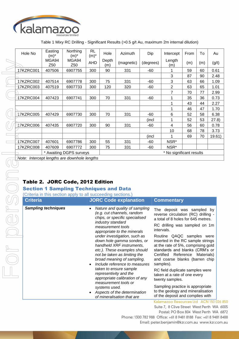
Table 1 Mixy RC Drilling - Significant Results (>0.5 g/t Au, maximum 2m internal dilution)
Table 2. JORC Code, 2012 Edition
Section 1 Sampling Techniques and Data
(Criteria in this section apply to all succeeding sections.)
Criteria JORC Code explanation Commentary
Sampling techniques Nature and quality of sampling (e.g. cut channels, random chips, or specific specialised industry standard measurement tools appropriate to the minerals under investigation, such as down hole gamma sondes, or handheld XRF instruments, etc.). These examples should not be taken as limiting the broad meaning of sampling.
Include reference to measures taken to ensure sample representivity and the appropriate calibration of any measurement tools or systems used.
Aspects of the determination of mineralisation that are
The deposit was sampled by reverse circulation (RC) drilling - a total of 8 holes for 645 metres.
RC drilling was sampled on 1m intervals.
Routine QAQC samples were inserted in the RC sample strings at the rate of 5%, comprising gold standards and blanks (CRM’s or Certified Reference Materials) and coarse blanks (barren chip samples).
RC field duplicate samples were taken at a rate of one every twenty samples.
Sampling practice is appropriate to the geology and mineralisation of the deposit and complies with
Hole No Easting
(m)* Northing
(m)* RL
(m)* Hole Azimuth Dip Intercept From To Au
MGA94
Z50 MGA94
Z50 AHD
Depth (m)
(magnetic) (degrees) Length
(m) (m) (m) (g/t)
17KZRC001 407506 6907755 300 90 331 -60 1 59 60 0.61
3 87 90 2.48
17KZRC002 407514 6907778 300 75 331 -60 3 63 66 1.09
17KZRC003 407519 6907733 300 120 320 -60 2 63 65 1.01
7 70 77 2.99
17KZRC004 407423 6907741 300 70 331 -60 1 35 36 0.73
1 43 44 2.27
1 46 47 1.70
17KZRC005 407429 6907730 300 70 331 -60 6 52 58 6.38
(incl 1 52 53 27.8)
17KZRC006 407435 6907720 300 90 331 -60 4 56 60 0.78
10 68 78 3.73
(incl 1 69 70 19.61)
17KZRC007 407601 6907786 300 55 331 -60 NSR*
17KZRC008 407609 6907772 300 75 331 -60 NSR*
* Awaiting DGPS surveys * No significant results
Note: Intercept lengths are downhole lengths
For
per
sona
l use
onl
y

Criteria JORC Code explanation Commentary
Material to the Public Report.
In cases where ‘industry standard’ work has been done this would be relatively simple (e.g. ‘reverse circulation drilling was used to obtain 1 m samples from which 3 kg was pulverised to produce a 30 g charge for fire assay’). In other cases more explanation may be required, such as where there is coarse gold that has inherent sampling problems. Unusual commodities or mineralisation types (e.g. submarine nodules) may warrant disclosure of detailed information.
industry best practice.
Historical holes within the drilling area were also reverse circulation (RC) drilling.
Drilling techniques Drill type (e.g. core, reverse circulation, open-hole hammer, rotary air blast, auger, Bangka, sonic, etc.) and details (e.g. core diameter, triple or standard tube, depth of diamond tails, face-sampling bit or other type, whether core is oriented and if so, by what method, etc.).
RC drilling was conducted with a modern track mounted drill rig utilising high pressure and high volume compressed air and a 140mm (5.5”) diameter face sampling percussion hammer.
Drill sample recovery Method of recording and assessing core and chip sample recoveries and results assessed.
Measures taken to maximise sample recovery and ensure representative nature of the samples.
Whether a relationship exists between sample recovery and grade and whether sample bias may have occurred due to preferential loss/gain of fine/coarse material.
RC sample recovery and sample condition (dry, moist or wet) was visually logged on the original drill logs and transferred to the digital drill hole database. Most samples were logged as dry with good recovery.
Logging Whether core and chip samples have been geologically and geotechnically logged to a level of detail to support appropriate Mineral Resource estimation, mining studies and metallurgical studies.
Whether logging is qualitative or quantitative in nature. Core
All RC chips were geologically logged. Lithology, veining, oxidation and weathering are recorded in the geology table of the drill hole database.
RC logging is qualitative and descriptive in nature.
Representative chip samples for every metre drilled are stored for
For
per
sona
l use
onl
y

Criteria JORC Code explanation Commentary
(or costean, channel, etc.) photography.
The total length and percentage of the relevant intersections logged.
reference.
Sub-sampling techniques and sample preparation
If core, whether cut or sawn and whether quarter, half or all core taken.
If non-core, whether riffled, tube sampled, rotary split, etc. and whether sampled wet or dry.
For all sample types, the nature, quality and appropriateness of the sample preparation technique.
Quality control procedures adopted for all sub-sampling stages to maximise representivity of samples.
Measures taken to ensure that the sampling is representative of the in situ material collected, including for instance results for field duplicate/second-half sampling.
Whether sample sizes are appropriate to the grain size of the material being sampled.
RC samples were sub-sampled using a rig mounted cone splitter to produce original and duplicate split samples of approximately 3kg weight, a standard industry practice. The duplicate splits were taken over a downhole zone estimated to contain the target mineralisation.
The splitter was routinely cleaned at the end of each drill rod (6m) or as needed if damp material clung to the splitter.
Duplicate samples were collected when splitting RC samples to assess the sampling precision.
Sample size assessment was not conducted but used sampling size typical for WA gold deposits.
Quality of assay data and laboratory tests
The nature, quality and appropriateness of the assaying and laboratory procedures used and whether the technique is considered partial or total.
For geophysical tools, spectrometers, handheld XRF instruments, etc., the parameters used in determining the analysis including instrument make and model, reading times, calibrations factors applied and their derivation, etc.
Nature of quality control procedures adopted (e.g. standards, blanks, duplicates, external laboratory checks) and whether acceptable levels of accuracy (i.e. lack of bias) and precision have been established.
RC samples were prepared and assayed at NATA accredited MinAnalytical Laboratory Services Pty Ltd in Perth.
RC samples were weighed, dried, and pulverized in total to nominal 85% passing 75 micron and a 50g pulp sub sample assayed for gold by fire assay with an AAS finish.
In addition to the Company QAQC samples included within the batches the laboratory includes its own CRM’s, blanks and duplicates with every batch.
For
per
sona
l use
onl
y

Criteria JORC Code explanation Commentary
Verification of sampling and assaying
The verification of significant intersections by either independent or alternative company personnel.
The use of twinned holes.
Documentation of primary data, data entry procedures, data verification, data storage (physical and electronic) protocols.
Discuss any adjustment to assay data.
Intersection assays were documented by a professional contractor to Kalamazoo Resources Ltd and independently verified by an experienced professional Exploration Manager at Kalamazoo Resources
All assay data were received in electronic format from MinAnalytical, checked and verified by Kalamazoo Resources Ltd.
No assay adjustment was applied.
Location of data points Accuracy and quality of surveys used to locate drill holes (collar and down-hole surveys), trenches, mine workings and other locations used in Mineral Resource estimation.
Specification of the grid system used.
Quality and adequacy of topographic control.
All drill hole collars were initially pegged using RTK differential GPS and will be re-surveyed post drilling, to x-y accuracy of 2cm and height (z) to +/- 10cm (relative to AHD).
All collar location data is in UTM grid (MGA94 Zone 50).
Collars were measured relative to two local control stations installed by Goldfields Technical Services in 2015.
Data spacing and distribution Data spacing for reporting of Exploration Results.
Whether the data spacing and distribution is sufficient to establish the degree of geological and grade continuity appropriate for the Mineral Resource and Ore Reserve estimation procedure(s) and classifications applied.
Whether sample compositing has been applied.
Holes are spaced at irregular intervals to infill historical drilling.
Current reporting is for progressive exploration results and not for Mineral Resource estimation.
Sample compositing over 4m intervals has been applied in zones expected to be barren, however results for these samples have not yet been received.
Orientation of data in relation to geological structure
Whether the orientation of sampling achieves unbiased sampling of possible structures and the extent to which this is known, considering the deposit type.
If the relationship between the drilling orientation and the orientation of key mineralised structures is considered to have introduced a sampling
Drill lines are oriented approximately at right angles to the currently interpreted strike of known mineralisation.
No bias is considered to have been introduced by the existing sampling orientation. F
or p
erso
nal u
se o
nly

Criteria JORC Code explanation Commentary
bias, this should be assessed and reported if material.
Sample security The measures taken to ensure sample security.
Samples were secured in closed polyweave sacks and bulka-bags for direct delivery via a registered transport company to the laboratory.
Audits or reviews The results of any audits or reviews of sampling techniques and data.
No external audits or reviews have been completed on behalf of Kalamazoo Resources Limited.
Section 2 Reporting of Exploration Results
Criteria JORC Code explanation Commentary
Mineral tenement and land tenure status
Type, reference name/number, location and ownership including agreements or material issues with third parties such as joint ventures, partnerships, overriding royalties, native title interests, historical sites, wilderness or national park and environmental settings.
The security of the tenure held at the time of reporting along with any known impediments to obtaining a licence to operate in the area.
Results reported are from the Mixy Prospect, located within M59/565, a granted mining lease within the Snake Well Project area, owned 100% by Kalamazoo Resources Limited.
M59/565 is in good standing and subject to completion of all normal pre-mining permitting requirements no impediment is forseen to obtaining a licence to operate.
Exploration done by other parties
Acknowledgment and appraisal of exploration by other parties.
Historical exploration of the Mixy Prospect was undertaken by Roebuck Resources, CRA Exploration and Giralia Resources.
Geology Deposit type, geological setting and style of mineralisation.
Mixy is a quartz lode hosted Archean gold deposit located within the Tallering Greenstone Belt of the western Murchison Province.
Drill hole Information
A summary of all information material to the understanding of the exploration results including a tabulation of the following information for all Material drill holes: o easting and northing of the drill hole
collar o elevation or RL (Reduced Level –
elevation above sea level in metres) of the drill hole collar
o dip and azimuth of the hole o down hole length and interception
depth o hole length.
If the exclusion of this information is justified on the basis that the information
All requisite drill hole information is tabulated elsewhere in this release.
For
per
sona
l use
onl
y

Criteria JORC Code explanation Commentary
is not Material and this exclusion does not detract from the understanding of the report, the Competent Person should clearly explain why this is the case.
Data aggregation methods
In reporting Exploration Results, weighting averaging techniques, maximum and/or minimum grade truncations (e.g. cutting of high grades) and cut-off grades are usually Material and should be stated.
Where aggregate intercepts incorporate short lengths of high grade results and longer lengths of low grade results, the procedure used for such aggregation should be stated and some typical examples of such aggregations should be shown in detail.
The assumptions used for any reporting of metal equivalent values should be clearly stated.
Drill hole intersections are reported above a lower cut-off grade of 0.5 g/t Au and no upper cut-off grade has been applied. Up to two metres of internal dilution have been included.
No metal equivalent reporting has been applied.
Relationship between mineralisation widths and intercept lengths
These relationships are particularly important in the reporting of Exploration Results.
If the geometry of the mineralisation with respect to the drill hole angle is known, its nature should be reported.
If it is not known and only the down hole lengths are reported, there should be a clear statement to this effect (e.g. ‘down hole length, true width not known’).
Interpretation of mineralised shapes is at an early stage and until more data is available and 3D modelling is completed only down hole lengths are reported. True widths are unknown.
Diagrams Appropriate maps and sections (with scales) and tabulations of intercepts should be included for any significant discovery being reported These should include, but not be limited to a plan view of drill hole collar locations and appropriate sectional views.
Included elsewhere in this release.
Balanced reporting
Where comprehensive reporting of all Exploration Results is not practicable, representative reporting of both low and high grades and/or widths should be practiced to avoid misleading reporting of Exploration Results.
All results above 1m at 0.5 g/t Au lower cut have been reported.
Other substantive exploration data
Other exploration data, if meaningful and material, should be reported including (but not limited to): geological observations; geophysical survey results; geochemical survey results; bulk samples – size and method of treatment; metallurgical test results; bulk density, groundwater, geotechnical and rock characteristics; potential deleterious or contaminating substances.
None to report with this release.
For
per
sona
l use
onl
y

Criteria JORC Code explanation Commentary
Further work The nature and scale of planned further work (e.g. tests for lateral extensions or depth extensions or large-scale step-out drilling).
Diagrams clearly highlighting the areas of possible extensions, including the main geological interpretations and future drilling areas, provided this information is not commercially sensitive.
Further drilling will be planned to infill the area subject of this program, and dependent on the results received for the balance of this program.
For
per
sona
l use
onl
y