Embed Size (px)
Citation preview
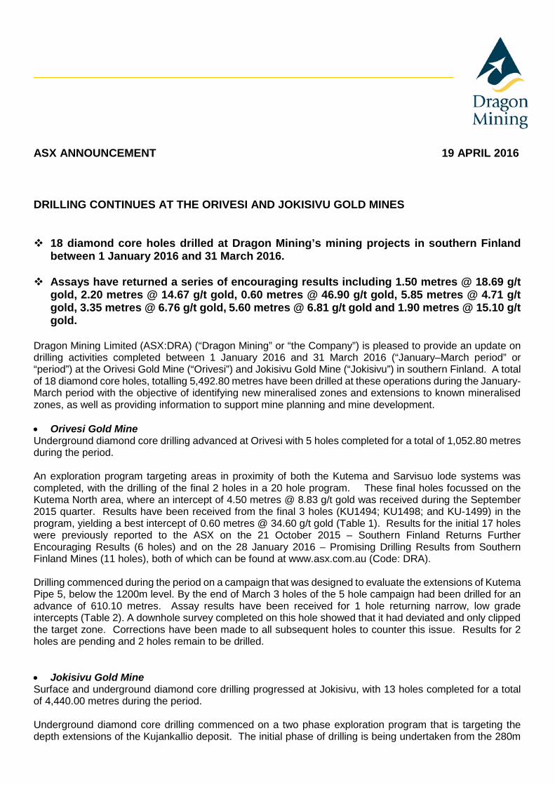
ASX ANNOUNCEMENT 19 APRIL 2016 DRILLING CONTINUES AT THE ORIVESI AND JOKISIVU GOLD MINES 18 diamond core holes drilled at Dragon Mining’s mining projects in southern Finland
between 1 January 2016 and 31 March 2016. Assays have returned a series of encouraging results including 1.50 metres @ 18.69 g/t
gold, 2.20 metres @ 14.67 g/t gold, 0.60 metres @ 46.90 g/t gold, 5.85 metres @ 4.71 g/t gold, 3.35 metres @ 6.76 g/t gold, 5.60 metres @ 6.81 g/t gold and 1.90 metres @ 15.10 g/t gold.
Dragon Mining Limited (ASX:DRA) (“Dragon Mining” or “the Company”) is pleased to provide an update on drilling activities completed between 1 January 2016 and 31 March 2016 (“January–March period” or “period”) at the Orivesi Gold Mine (“Orivesi”) and Jokisivu Gold Mine (“Jokisivu”) in southern Finland. A total of 18 diamond core holes, totalling 5,492.80 metres have been drilled at these operations during the January-March period with the objective of identifying new mineralised zones and extensions to known mineralised zones, as well as providing information to support mine planning and mine development. • Orivesi Gold Mine Underground diamond core drilling advanced at Orivesi with 5 holes completed for a total of 1,052.80 metres during the period. An exploration program targeting areas in proximity of both the Kutema and Sarvisuo lode systems was completed, with the drilling of the final 2 holes in a 20 hole program. These final holes focussed on the Kutema North area, where an intercept of 4.50 metres @ 8.83 g/t gold was received during the September 2015 quarter. Results have been received from the final 3 holes (KU1494; KU1498; and KU-1499) in the program, yielding a best intercept of 0.60 metres @ 34.60 g/t gold (Table 1). Results for the initial 17 holes were previously reported to the ASX on the 21 October 2015 – Southern Finland Returns Further Encouraging Results (6 holes) and on the 28 January 2016 – Promising Drilling Results from Southern Finland Mines (11 holes), both of which can be found at www.asx.com.au (Code: DRA). Drilling commenced during the period on a campaign that was designed to evaluate the extensions of Kutema Pipe 5, below the 1200m level. By the end of March 3 holes of the 5 hole campaign had been drilled for an advance of 610.10 metres. Assay results have been received for 1 hole returning narrow, low grade intercepts (Table 2). A downhole survey completed on this hole showed that it had deviated and only clipped the target zone. Corrections have been made to all subsequent holes to counter this issue. Results for 2 holes are pending and 2 holes remain to be drilled. • Jokisivu Gold Mine Surface and underground diamond core drilling progressed at Jokisivu, with 13 holes completed for a total of 4,440.00 metres during the period. Underground diamond core drilling commenced on a two phase exploration program that is targeting the depth extensions of the Kujankallio deposit. The initial phase of drilling is being undertaken from the 280m
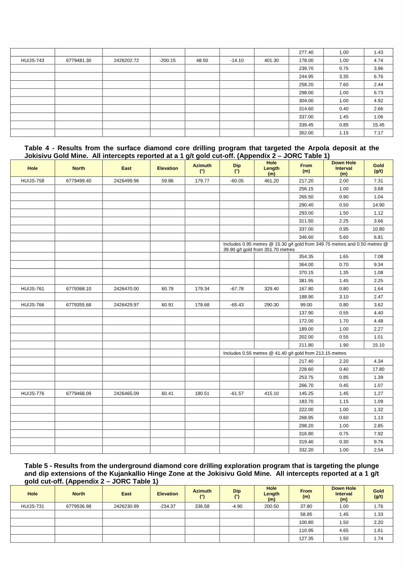
level, comprising 10 drill holes. The 9 hole second phase will be undertaken from the 350m level. By the end of March 4 holes had been drilled for 1,439.90 metres. Results have been received from 3 holes returning better intercepts of 5.85 metres @ 4.71 g/t gold, 3.35 metres @ 6.76 g/t gold and 7.66 metres @ 2.44 g/t gold (Table 3). Results from 1 hole are pending and 6 holes remain to be drilled to complete the initial phase of the program. A program of diamond core drilling from the surface commenced during the January-March period targeting the Arpola deposit. Nine holes of the 27 hole program had been completed by the end of March for 3,000.10 metres. Assay results have been received from three full holes and one part hole returning better intercepts including 2.00 metres @ 7.31 g/t gold, 1.65 metres @ 7.08 g/t gold, 2.20 metres @ 4.34 g/t gold, 5.60 metres @ 6.81 g/t gold and 1.90 metres @ 15.10 g/t gold (Table 4). Results are pending from one part hole and 5 complete holes and 18 holes remain to be drilled to complete the program. During the January-March period assay results were also received for the final 5 holes of an 8 hole exploration program that was drilled during the December 2015 quarter targeting the plunge and dip extensions of the Kujankallio Hinge Zone. The final 5 holes yielded a series of intercepts that can be readily added to the Main Zone or Hinge Zone resource models. Better results received include 1.50 metres @ 18.69 g/t gold, 0.65 metres @ 49.90 g/t gold, 5.90 metres @ 2.52 g/t gold, 4.20 metres @ 3.87 g/t gold, 1.60 metres @ 8.47 g/t gold and 2.20 metres @ 14.67 g/t gold (Table 5). Results for the initial 3 holes were previously released to the ASX on the 28 January 2016 – Promising Drilling Results from Southern Finland Mines, which can be found at www.asx.com.au (Code: DRA). For and on behalf of Dragon Mining Limited
Competent Persons Statement The information in this report that relates to Exploration Results previously unreleased is based on and fairly represents information and supporting documentation compiled by Mr. Neale Edwards BSc (Hons), a Fellow of the Australian Institute of Geoscientists who is a full time employee of the company and has sufficient experience which is relevant to the style of mineralisation and type of deposit under consideration and to the activity which he is undertaking to qualify as Competent Person as defined in the 2012 Edition of the Australasian Code of Reporting for Exploration Results, Mineral Resources and Ore Reserves. Mr. Neale Edwards has provided written consent for the inclusion in the announcement of the matters based on his information in the form and context in which it appears. The information in this report that relates to Exploration Results previously released to the ASX on the 21 October 2015 – Southern Finland Returns Further Encouraging Results and 28 January 2016 – Promising Drilling Results from Southern Finland Mines. These releases can be found at www.asx.com.au (Code:DRA). These releases fairly represent information and supporting documentation that was compiled by Mr. Neale Edwards BSc (Hons), a Fellow of the Australian Institute of Geoscientists, who is a full time employee of the company and has sufficient experience which is relevant to the style of mineralisation and type of deposit under consideration and to the activity which he is undertaking to qualify as Competent Persons as defined in the 2012 Edition of the Australasian Code of Reporting for Exploration Results, Mineral Resources and Ore Reserves. Written consent was previously provided by Mr. Neale Edwards for the releases dated the 21 October 2015 and 28 January 2016. Mr. Neale Edwards BSc (Hons), a Fellow of the Australian Institute of Geoscientists, confirms that the form and context in which the Exploration Results are presented in this report have not been materially modified from the releases dated 21 October 2015 and 28 January 2016. Mr. Neale Edwards has provided written consent approving the inclusion of the Exploration Results in the report in the form and context in which they appear.
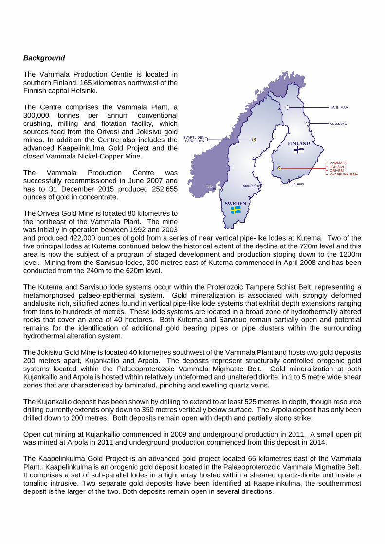
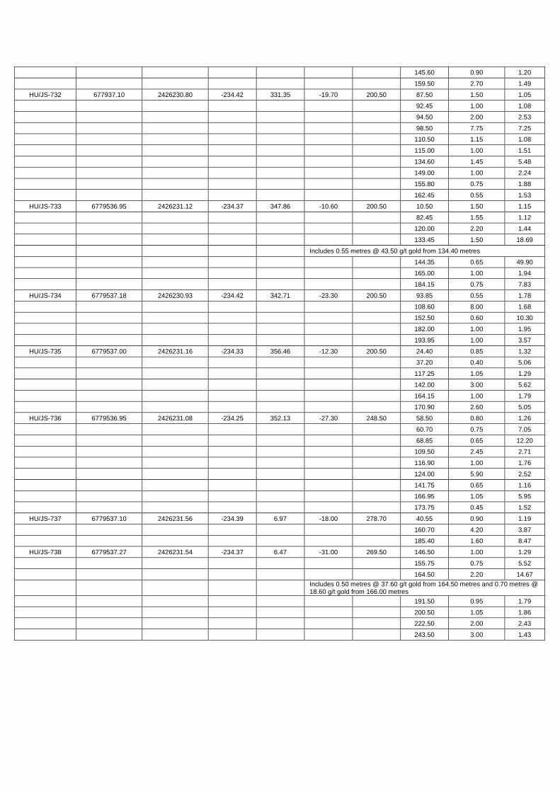
Background The Vammala Production Centre is located in southern Finland, 165 kilometres northwest of the Finnish capital Helsinki. The Centre comprises the Vammala Plant, a 300,000 tonnes per annum conventional crushing, milling and flotation facility, which sources feed from the Orivesi and Jokisivu gold mines. In addition the Centre also includes the advanced Kaapelinkulma Gold Project and the closed Vammala Nickel-Copper Mine. The Vammala Production Centre was successfully recommissioned in June 2007 and has to 31 December 2015 produced 252,655 ounces of gold in concentrate. The Orivesi Gold Mine is located 80 kilometres to the northeast of the Vammala Plant. The mine was initially in operation between 1992 and 2003 and produced 422,000 ounces of gold from a series of near vertical pipe-like lodes at Kutema. Two of the five principal lodes at Kutema continued below the historical extent of the decline at the 720m level and this area is now the subject of a program of staged development and production stoping down to the 1200m level. Mining from the Sarvisuo lodes, 300 metres east of Kutema commenced in April 2008 and has been conducted from the 240m to the 620m level. The Kutema and Sarvisuo lode systems occur within the Proterozoic Tampere Schist Belt, representing a metamorphosed palaeo-epithermal system. Gold mineralization is associated with strongly deformed andalusite rich, silicified zones found in vertical pipe-like lode systems that exhibit depth extensions ranging from tens to hundreds of metres. These lode systems are located in a broad zone of hydrothermally altered rocks that cover an area of 40 hectares. Both Kutema and Sarvisuo remain partially open and potential remains for the identification of additional gold bearing pipes or pipe clusters within the surrounding hydrothermal alteration system. The Jokisivu Gold Mine is located 40 kilometres southwest of the Vammala Plant and hosts two gold deposits 200 metres apart, Kujankallio and Arpola. The deposits represent structurally controlled orogenic gold systems located within the Palaeoproterozoic Vammala Migmatite Belt. Gold mineralization at both Kujankallio and Arpola is hosted within relatively undeformed and unaltered diorite, in 1 to 5 metre wide shear zones that are characterised by laminated, pinching and swelling quartz veins. The Kujankallio deposit has been shown by drilling to extend to at least 525 metres in depth, though resource drilling currently extends only down to 350 metres vertically below surface. The Arpola deposit has only been drilled down to 200 metres. Both deposits remain open with depth and partially along strike. Open cut mining at Kujankallio commenced in 2009 and underground production in 2011. A small open pit was mined at Arpola in 2011 and underground production commenced from this deposit in 2014. The Kaapelinkulma Gold Project is an advanced gold project located 65 kilometres east of the Vammala Plant. Kaapelinkulma is an orogenic gold deposit located in the Palaeoproterozoic Vammala Migmatite Belt. It comprises a set of sub-parallel lodes in a tight array hosted within a sheared quartz-diorite unit inside a tonalitic intrusive. Two separate gold deposits have been identified at Kaapelinkulma, the southernmost deposit is the larger of the two. Both deposits remain open in several directions.
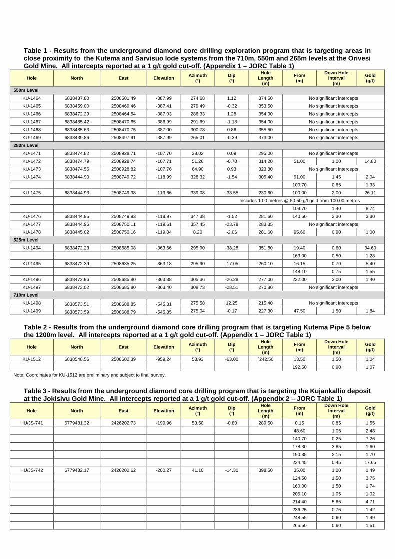
Table 1 - Results from the underground diamond core drilling exploration program that is targeting areas in close proximity to the Kutema and Sarvisuo lode systems from the 710m, 550m and 265m levels at the Orivesi Gold Mine. All intercepts reported at a 1 g/t gold cut-off. (Appendix 1 – JORC Table 1)
Hole North East Elevation Azimuth (°)
Dip (°)
Hole Length
(m) From (m)
Down Hole Interval
(m) Gold (g/t)
550m Level KU-1464 6838437.80 2508501.49 -387.99 274.68 1.12 374.50 No significant intercepts KU-1465 6838459.00 2508469.46 -387.41 279.49 -0.32 353.50 No significant intercepts
KU-1466 6838472.29 2508464.54 -387.03 286.33 1.28 354.00 No significant intercepts
KU-1467 6838485.42 2508470.65 -386.99 291.69 -1.18 354.00 No significant intercepts
KU-1468 6838485.63 2508470.75 -387.00 300.78 0.86 355.50 No significant intercepts KU-1469 6838439.86 2508497.91 -387.99 265.01 -0.39 373.00 No significant intercepts
280m Level KU-1471 6838474.82 2508928.71 -107.70 38.02 0.09 295.00 No significant intercepts
KU-1472 6838474.79 2508928.74 -107.71 51.26 -0.70 314.20 51.00 1.00 14.80 KU-1473 6838474.55 2508928.82 -107.76 64.90 0.93 323.80 No significant intercepts
KU-1474 6838444.90 2508749.72 -118.99 328.32 -1.54 305.40 91.00 1.45 2.04
100.70 0.65 1.33
KU-1475 6838444.93 2508749.98 -119.66 339.08 -33.55 230.60 100.00 2.00 26.11 Includes 1.00 metres @ 50.50 g/t gold from 100.00 metres
109.70 1.40 8.74
KU-1476 6838444.95 2508749.93 -118.97 347.38 -1.52 281.60 140.50 3.30 3.30
KU-1477 6838444.96 2508750.11 -119.61 357.45 -23.78 283.35 No significant intercepts KU-1478 6838445.02 2508750.16 -119.04 8.20 -2.06 281.60 95.60 0.90 1.00
525m Level KU-1494 6838472.23 2508685.08 -363.66 295.90 -38.28 351.80 19.40 0.60 34.60
163.00 0.50 1.28 KU-1495 6838472.39 2508685.25 -363.18 295.90 -17.05 260.10 16.15 0.70 5.40
148.10 0.75 1.55
KU-1496 6838472.96 2508685.80 -363.38 305.36 -26.28 277.00 232.00 2.00 1.40
KU-1497 6838473.02 2508685.80 -363.40 308.73 -28.51 270.80 No significant intercepts 710m Level
KU-1498 6838573.51 2508688.85 -545.31 275.58 12.25 215.40 No significant intercepts
KU-1499 6838573.59 2508688.79 -545.85 275.04 -0.17 227.30 47.50 1.50 1.84
Table 2 - Results from the underground diamond core drilling program that is targeting Kutema Pipe 5 below the 1200m level. All intercepts reported at a 1 g/t gold cut-off. (Appendix 1 – JORC Table 1)
Hole North East Elevation Azimuth (°)
Dip (°)
Hole Length
(m) From (m)
Down Hole Interval
(m) Gold (g/t)
KU-1512 6838548.56 2508602.39 -959.24 53.93 -63.00 `242.50 13.50 1.50 1.04
192.50 0.90 1.07
Note: Coordinates for KU-1512 are preliminary and subject to final survey.
Table 3 - Results from the underground diamond core drilling program that is targeting the Kujankallio deposit at the Jokisivu Gold Mine. All intercepts reported at a 1 g/t gold cut-off. (Appendix 2 – JORC Table 1)
Hole North East Elevation Azimuth (°)
Dip (°)
Hole Length
(m) From (m)
Down Hole Interval
(m) Gold (g/t)
HU/JS-741 6779481.32 2426202.73 -199.96 53.50 -0.80 289.50 0.15 0.85 1.55
48.60 1.05 2.48 140.70 0.25 7.26
178.30 3.85 1.60
190.35 2.15 1.70
224.45 0.45 17.65 HU/JS-742 6779482.17 2426202.62 -200.27 41.10 -14.30 398.50 35.00 1.00 1.49
124.50 1.50 3.75
160.00 1.50 1.74
205.10 1.05 1.02 214.40 5.85 4.71
236.25 0.75 1.42
248.55 0.60 1.49
265.50 0.60 1.51
277.40 1.00 1.43
HU/JS-743 6779481.30 2426202.72 -200.15 48.50 -14.10 401.30 178.00 1.00 4.74 239.70 0.75 3.96
244.95 3.35 6.76
258.20 7.60 2.44
298.00 1.00 6.73 304.00 1.00 4.92
314.60 0.40 2.66
337.00 1.45 1.06
339.45 0.85 15.45 352.00 1.15 7.17
Table 4 - Results from the surface diamond core drilling program that targeted the Arpola deposit at the Jokisivu Gold Mine. All intercepts reported at a 1 g/t gold cut-off. (Appendix 2 – JORC Table 1)
Hole North East Elevation Azimuth (°)
Dip (°)
Hole Length
(m) From (m)
Down Hole Interval
(m) Gold (g/t)
HU/JS-758 6779499.40 2426499.96 59.86 179.77 -60.05 461.20 217.20 2.00 7.31 256.15 1.00 3.68
265.50 0.90 1.04
290.40 0.50 14.90
293.00 1.50 1.12 311.50 2.25 3.66
337.00 0.95 10.80
346.60 5.60 6.81
Includes 0.95 metres @ 15.30 g/t gold from 349.75 metres and 0.50 metres @ 39.90 g/t gold from 351.70 metres
354.35 1.65 7.08
364.00 0.70 9.34 370.15 1.35 1.08
381.95 1.45 2.25
HU/JS-761 6779368.10 2426470.00 60.79 179.34 -67.78 329.40 167.80 0.80 1.64
188.90 3.10 2.47 HU/JS-766 6779355.68 2426429.97 60.91 178.68 -65.43 290.30 99.00 0.80 3.62
137.90 0.55 4.40
172.00 1.70 4.48
189.00 1.00 2.27 202.00 0.55 1.01
211.80 1.90 15.10
Includes 0.55 metres @ 41.40 g/t gold from 213.15 metres
217.40 2.20 4.34 228.60 0.40 17.80
253.75 0.85 1.39
266.70 0.45 1.07
HU/JS-776 6779468.09 2426465.09 60.41 180.51 -61.57 415.10 145.25 1.45 1.27 183.70 1.15 1.09
222.00 1.00 1.32
268.95 0.60 1.13
298.20 1.00 2.85 316.80 0.75 7.92
319.40 0.30 9.76
332.20 1.00 2.54
Table 5 - Results from the underground diamond core drilling exploration program that is targeting the plunge and dip extensions of the Kujankallio Hinge Zone at the Jokisivu Gold Mine. All intercepts reported at a 1 g/t gold cut-off. (Appendix 2 – JORC Table 1)
Hole North East Elevation Azimuth (°)
Dip (°)
Hole Length
(m) From (m)
Down Hole Interval
(m) Gold (g/t)
HU/JS-731 6779536.98 2426230.99 -234.37 336.58 -4.90 200.50 37.80 1.00 1.76 58.85 1.45 1.33
100.80 1.50 2.20
110.95 4.65 1.61
127.35 1.50 1.74
145.60 0.90 1.20
159.50 2.70 1.49 HU/JS-732 677937.10 2426230.80 -234.42 331.35 -19.70 200.50 87.50 1.50 1.05
92.45 1.00 1.08
94.50 2.00 2.53
98.50 7.75 7.25 110.50 1.15 1.08
115.00 1.00 1.51
134.60 1.45 5.48
149.00 1.00 2.24 155.80 0.75 1.88
162.45 0.55 1.53
HU/JS-733 6779536.95 2426231.12 -234.37 347.86 -10.60 200.50 10.50 1.50 1.15
82.45 1.55 1.12 120.00 2.20 1.44
133.45 1.50 18.69
Includes 0.55 metres @ 43.50 g/t gold from 134.40 metres
144.35 0.65 49.90 165.00 1.00 1.94
184.15 0.75 7.83
HU/JS-734 6779537.18 2426230.93 -234.42 342.71 -23.30 200.50 93.85 0.55 1.78
108.60 8.00 1.68 152.50 0.60 10.30
182.00 1.00 1.95
193.95 1.00 3.57
HU/JS-735 6779537.00 2426231.16 -234.33 356.46 -12.30 200.50 24.40 0.85 1.32 37.20 0.40 5.06
117.25 1.05 1.29
142.00 3.00 5.62
164.15 1.00 1.79 170.90 2.60 5.05
HU/JS-736 6779536.95 2426231.08 -234.25 352.13 -27.30 248.50 58.50 0.80 1.26
60.70 0.75 7.05
68.85 0.65 12.20 109.50 2.45 2.71
116.90 1.00 1.76
124.00 5.90 2.52
141.75 0.65 1.16 166.95 1.05 5.95
173.75 0.45 1.52
HU/JS-737 6779537.10 2426231.56 -234.39 6.97 -18.00 278.70 40.55 0.90 1.19
160.70 4.20 3.87 185.40 1.60 8.47
HU/JS-738 6779537.27 2426231.54 -234.37 6.47 -31.00 269.50 146.50 1.00 1.29
155.75 0.75 5.52
164.50 2.20 14.67
Includes 0.50 metres @ 37.60 g/t gold from 164.50 metres and 0.70 metres @ 18.60 g/t gold from 166.00 metres
191.50 0.95 1.79
200.50 1.05 1.86 222.50 2.00 2.43
243.50 3.00 1.43
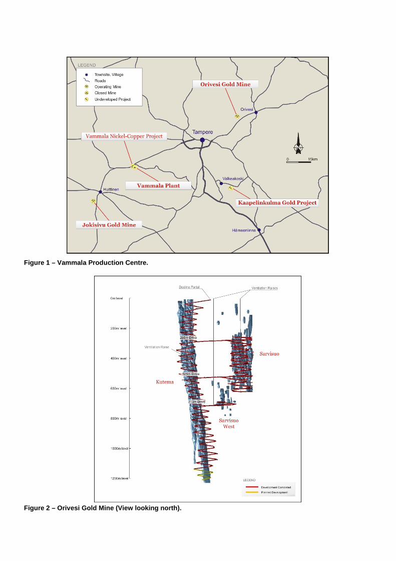
Figure 1 – Vammala Production Centre. Figure 2 – Orivesi Gold Mine (View looking north).
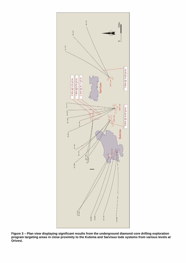
Figure 3 – Plan view displaying significant results from the underground diamond core drilling exploration program targeting areas in close proximity to the Kutema and Sarvisuo lode systems from various levels at Orivesi.
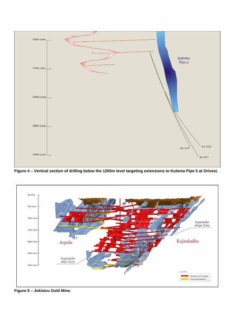
Figure 4 – Vertical section of drilling below the 1200m level targeting extensions to Kutema Pipe 5 at Orivesi. Figure 5 – Jokisivu Gold Mine.
Figure 6 – Significant results from the underground diamond core drilling program that is targeting the extensions of the Kujankallio deposit at Jokisivu. Figure 7 – Diamond core hole plan of recent drilling completed over the Arpola deposit at Jokisivu.
Figure 8 – Significant results from the underground diamond core drilling exploration program that targeted the plunge and dip extensions of the Kujankallio Hinge Zone at Jokisivu.
Appendix 1 JORC Code Table 1 - Orivesi Drilling Programs
Section 1 - Sampling Techniques and Data (Criteria in this Section apply to all succeeding sections) Criteria Explanat ion Commentary Sampling Techniques Nature and quality of
sampling (eg cut channels, random chips, or specific specialised industry standard measurement tools appropriate to the minerals under investigation, such as down hole gamma sondes, or handheld XRF instruments, etc). These examples should not be taken as limiting the broad meaning of sampling.
The Kutema and Sarvisuo lode systems have been sampled by a series of underground and surface diamond core drill holes and underground production holes (sludge). In the reported programs, Dragon Mining has completed 5 WL-56 (39mm) diamond core drill holes for an advance of 1,052.80 metres. These holes are part of a 20 hole exploration program that is targeting areas in close proximity of both the Kutema and Sarvisuo lode systems and a 5 hole exploration program that is evaluating the depth extensions of Kutema Pipe 5 below the 1200m level. Diamond drill holes were drilled at variable spacing’s. Drill holes were surveyed on the local mine grid.
Include reference to measures taken to ensure sample representivity and the appropriate calibration of any measurement tools or system used.
The majority of drill holes are underground drill holes and orientated predominantly to an azimuth of grid north and drilled at various angles in a ‘fan’ array to optimally intersect the sub-vertical orientation of the mineralised trends. Drill hole collar co-ordinates are accurately surveyed by qualified mine surveyors and tied into the local mine grid using a Leica TCRP 1205 R300 Total Station. Deviation surveys are completed on all drill holes using a Maxibor II device. All drill core is geologically and geotechnically logged, photographed and mineralised zones sampled with lithological control. Sampling and QAQC protocols are as per industry best applicable practice.
Aspects of the determination of mineralisation that are Material to the Public Report. In cases where ‘industry standard’ work has been done this would be relatively simple (eg ‘reverse circulation drilling was used to obtain 1 m samples from which 3 kg was pulverised to produce a 30 g charge for fire assay’). In other cases more explanation may be required, such as where there is coarse gold that has inherent sampling problems. Unusual commodities or mineralisation types (eg submarine nodules) may warrant disclosure of detailed information.
Drilling at Orivesi has been conducted by Lohja Oy, Outokumpu and Dragon Mining. Diamond core drilling by Lohja and Outokumpu used 45mm diameter core (T56) with sampling at varying intervals based on geological boundaries. Lohja used mainly VTT Laboratory in Finland for assaying. In 1992-2003 (Outokumpu), sample preparation and analysis were undertaken at the local independent laboratory (GAL and later VTT) in the town of Outokumpu using Fire-Assay with AAS or ICP finish. Diamond core drilling by Dragon Mining used 39mm, 40.7mm and 50mm core diameter (WL-56, BQTK and NQ2) with sampling and analysis as described above for Outokumpu drilling. In June 2008, the independent sample preparation laboratory in the town of Outokumpu became part of ALS Chemex laboratories.

Section 1 - Sampling Techniques and Data (Criteria in this Section apply to all succeeding sections) Criteria Explanat ion Commentary Drilling Techniques Drill type (eg core, reverse
circulation, open-hole hammer, rotary air blast, auger, Bangka, sonic, etc) and details (eg core diameter, triple or standard tube, depth of diamond tails, face-sampling bit or other type, whether core is oriented and if so, by what method, etc).
All drilling in the recent campaigns was completed by WL-56 (39mm) diamond core methods. Core is collected with a standard tube. Core is not orientated and hole deviation surveys are completed on all drill holes using a Maxibor II device.
Drill Sample Recovery Method of recording and assessing core and chip sample recoveries and results assessed.
Diamond core was reconstructed into continuous runs with depths checked against core blocks. Core loss observations were noted by geologists during the logging process. All information is recorded in the database.
Measures taken to maximise sample recovery and ensure representative nature of the samples.
Recoveries from diamond core were recorded in the supplied database, with an average core recovery of >99%. Lost core was also routinely recorded. Drilling is undertaken in primary rock material. All drilling is planned to avoid existing underground development. An experienced underground drilling contract group is engaged to undertake the program of work. Drilling contractors are supervised and routinely monitored by company personnel.
Whether a relationship exists between sample recovery and grade and whether sample bias may have occurred due to preferential loss/gain of fine/coarse material.
No relationship was noted between sample recovery and grade. The mineralised zones have predominantly been intersected by diamond core with generally good core recoveries. The consistency of the mineralised intervals suggests sampling bias due to material loss or gain is not an issue.
Logging Whether core and chip samples have been geologically and geotechnically logged to a level of detail to support appropriate Mineral Resource estimation, mining studies and metallurgical studies.
All holes were logged by company geologists to a high level of detail that will support Mineral Resource estimation and mining studies. Diamond holes were logged for recovery, RQD, number and type of defects. The database contains tables with information recorded for alpha/beta angles, dips, azimuths, and true dips. Specific indicator minerals and the amount and type of ore textures and ore minerals were also recorded within separate tables.
Whether logging is qualitative or quantitative in nature. Core (or costean, channel, etc) photography.
Drill samples were logged for lithology, rock type, colour, mineralisation, alteration, and texture. Logging is a mix of qualitative and quantitative observations. It has been standard practice that all diamond core be routinely photographed.
The total length and percentage of the relevant intersections logged.
All holes were logged in full.
Sub-sampling Techniques and Sample Preparation
If cut, whether cut or sawn and whether quarter, half or all core taken.
Primarily full core samples of select zones are collected for analysis.
Section 1 - Sampling Techniques and Data (Criteria in this Section apply to all succeeding sections) Criteria Explanat ion Commentary
If non-core, whether riffled, tube sampled, rotary split, etc and whether sampled wet or dry.
Not applicable. All drilling is completed by diamond core methods.
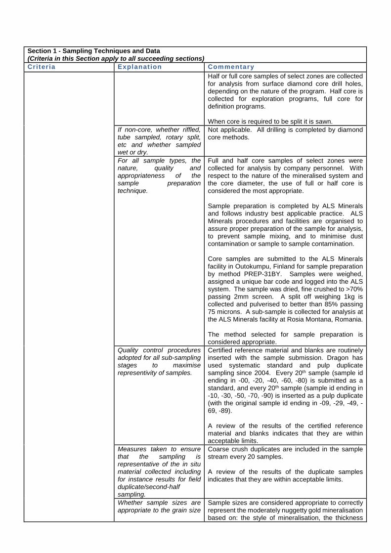
For all sample types, the nature, quality and appropriateness of the sample preparation technique.
Full core samples of select zones are primarily collected for analysis by company personnel. In some cases, core is cut in half or quarter using a core saw with half or quarter core is sent for analysis. Sampling of diamond core uses industry standard techniques. Core sampling was undertaken at intervals from 0.3m to 2.5m based on geological boundaries with the average sample length being around 1.5m. Whole core was generally sent for analysis, although some half core sampling has been carried out at various times. With respect to the nature of the mineralised system and the core diameter, the use of full core is considered appropriate. Sample preparation is completed by ALS Minerals and follows industry best applicable practice. ALS Minerals procedures and facilities are organised to assure proper preparation of the sample for analysis, to prevent sample mixing, and to minimise dust contamination or sample to sample contamination. Core samples are submitted to the ALS Minerals facility in Outokumpu, Finland for sample preparation by method PREP-31BY. Samples were weighed, assigned a unique bar code and logged into the ALS system. The sample was dried, fine crushed to >70% passing 2mm screen. A split off weighing 1kg is collected and pulverised to better than 85% passing 75 microns. A sub-sample is collected for analysis at the ALS Minerals facility at Rosia Montana, Romania. The method selected for sample preparation is considered appropriate.
Quality control procedures adopted for all sub-sampling stages to maximise representivity of samples.
Certified reference material and blanks are routinely inserted with the sample submission. Dragon Mining has used systematic standard and pulp duplicate sampling since 2004. Every 20th sample (sample id ending in -00, -20, -40, -60, -80) is submitted as a standard, and every 20th sample (sample id ending in -10, -30, -50, -70, -90) is inserted as a pulp duplicate (with the original sample id ending in -09, -29, -49, -69, -89). A review of the results of the certified reference material and blanks indicates that they are within acceptable limits.
Measures taken to ensure that the sampling is representative of the in situ material collected including for instance results for field duplicate/second-half sampling.
Coarse crush duplicates are included in the sample stream every 20 samples. A review of the results of the duplicate samples indicates that they are within acceptable limits.
Section 1 - Sampling Techniques and Data (Criteria in this Section apply to all succeeding sections) Criteria Explanat ion Commentary
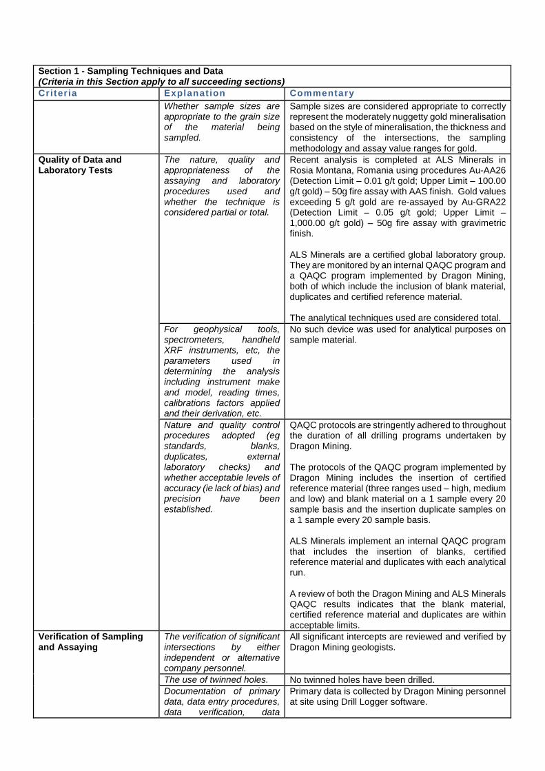
Whether sample sizes are appropriate to the grain size of the material being sampled.
Sample sizes are considered appropriate to correctly represent the moderately nuggetty gold mineralisation based on the style of mineralisation, the thickness and consistency of the intersections, the sampling methodology and assay value ranges for gold.
Quality of Data and Laboratory Tests
The nature, quality and appropriateness of the assaying and laboratory procedures used and whether the technique is considered partial or total.
Recent analysis is completed at ALS Minerals in Rosia Montana, Romania using procedures Au-AA26 (Detection Limit – 0.01 g/t gold; Upper Limit – 100.00 g/t gold) – 50g fire assay with AAS finish. Gold values exceeding 5 g/t gold are re-assayed by Au-GRA22 (Detection Limit – 0.05 g/t gold; Upper Limit – 1,000.00 g/t gold) – 50g fire assay with gravimetric finish. ALS Minerals are a certified global laboratory group. They are monitored by an internal QAQC program and a QAQC program implemented by Dragon Mining, both of which include the inclusion of blank material, duplicates and certified reference material. The analytical techniques used are considered total.
For geophysical tools, spectrometers, handheld XRF instruments, etc, the parameters used in determining the analysis including instrument make and model, reading times, calibrations factors applied and their derivation, etc.
No such device was used for analytical purposes on sample material.
Nature and quality control procedures adopted (eg standards, blanks, duplicates, external laboratory checks) and whether acceptable levels of accuracy (ie lack of bias) and precision have been established.
QAQC protocols are stringently adhered to throughout the duration of all drilling programs undertaken by Dragon Mining. The protocols of the QAQC program implemented by Dragon Mining includes the insertion of certified reference material (three ranges used – high, medium and low) and blank material on a 1 sample every 20 sample basis and the insertion duplicate samples on a 1 sample every 20 sample basis. ALS Minerals implement an internal QAQC program that includes the insertion of blanks, certified reference material and duplicates with each analytical run. A review of both the Dragon Mining and ALS Minerals QAQC results indicates that the blank material, certified reference material and duplicates are within acceptable limits.
Verification of Sampling and Assaying
The verification of significant intersections by either independent or alternative company personnel.
All significant intercepts are reviewed and verified by Dragon Mining geologists.
The use of twinned holes. No twinned holes have been drilled. Documentation of primary data, data entry procedures, data verification, data
Primary data is collected by Dragon Mining personnel at site using Drill Logger software.
Section 1 - Sampling Techniques and Data (Criteria in this Section apply to all succeeding sections) Criteria Explanat ion Commentary
storage (physical and electronic) protocols.
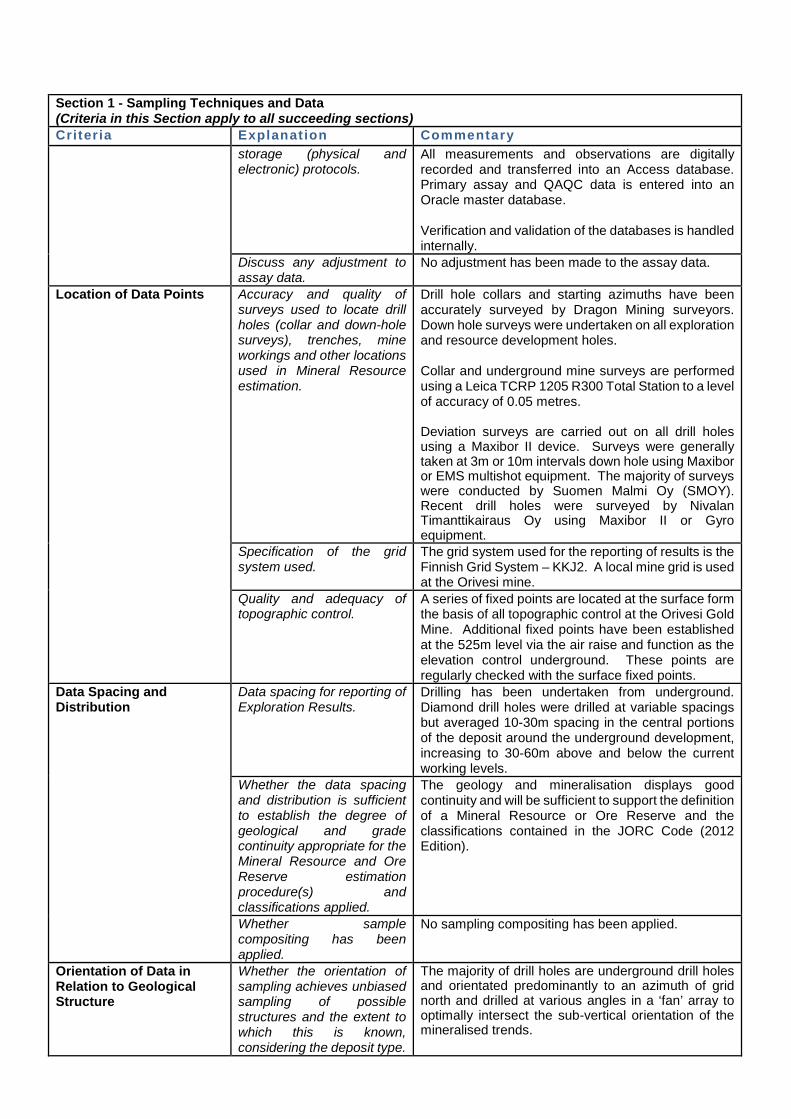
All measurements and observations are digitally recorded and transferred into an Access database. Primary assay and QAQC data is entered into an Oracle master database. Verification and validation of the databases is handled internally.
Discuss any adjustment to assay data.
No adjustment has been made to the assay data.
Location of Data Points Accuracy and quality of surveys used to locate drill holes (collar and down-hole surveys), trenches, mine workings and other locations used in Mineral Resource estimation.
Drill hole collars and starting azimuths have been accurately surveyed by Dragon Mining surveyors. Down hole surveys were undertaken on all exploration and resource development holes. Collar and underground mine surveys are performed using a Leica TCRP 1205 R300 Total Station to a level of accuracy of 0.05 metres. Deviation surveys are carried out on all drill holes using a Maxibor II device. Surveys were generally taken at 3m or 10m intervals down hole using Maxibor or EMS multishot equipment. The majority of surveys were conducted by Suomen Malmi Oy (SMOY). Recent drill holes were surveyed by Nivalan Timanttikairaus Oy using Maxibor II or Gyro equipment.
Specification of the grid system used.
The grid system used for the reporting of results is the Finnish Grid System – KKJ2. A local mine grid is used at the Orivesi mine.
Quality and adequacy of topographic control.
A series of fixed points are located at the surface form the basis of all topographic control at the Orivesi Gold Mine. Additional fixed points have been established at the 525m level via the air raise and function as the elevation control underground. These points are regularly checked with the surface fixed points.
Data Spacing and Distribution
Data spacing for reporting of Exploration Results.
Drilling has been undertaken from underground. Diamond drill holes were drilled at variable spacings but averaged 10-30m spacing in the central portions of the deposit around the underground development, increasing to 30-60m above and below the current working levels.
Whether the data spacing and distribution is sufficient to establish the degree of geological and grade continuity appropriate for the Mineral Resource and Ore Reserve estimation procedure(s) and classifications applied.
The geology and mineralisation displays good continuity and will be sufficient to support the definition of a Mineral Resource or Ore Reserve and the classifications contained in the JORC Code (2012 Edition).
Whether sample compositing has been applied.
No sampling compositing has been applied.
Orientation of Data in Relation to Geological Structure
Whether the orientation of sampling achieves unbiased sampling of possible structures and the extent to which this is known, considering the deposit type.
The majority of drill holes are underground drill holes and orientated predominantly to an azimuth of grid north and drilled at various angles in a ‘fan’ array to optimally intersect the sub-vertical orientation of the mineralised trends.
Section 1 - Sampling Techniques and Data (Criteria in this Section apply to all succeeding sections) Criteria Explanat ion Commentary
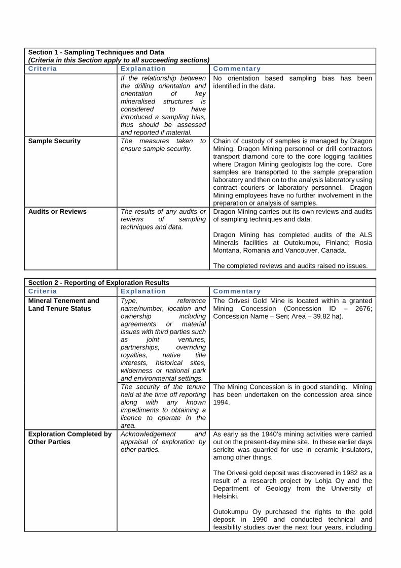
If the relationship between the drilling orientation and orientation of key mineralised structures is considered to have introduced a sampling bias, thus should be assessed and reported if material.
No orientation based sampling bias has been identified in the data.
Sample Security The measures taken to ensure sample security.
Chain of custody of samples is managed by Dragon Mining. Dragon Mining personnel or drill contractors transport diamond core to the core logging facilities where Dragon Mining geologists log the core. Core samples are transported to the sample preparation laboratory and then on to the analysis laboratory using contract couriers or laboratory personnel. Dragon Mining employees have no further involvement in the preparation or analysis of samples.
Audits or Reviews The results of any audits or reviews of sampling techniques and data.
Dragon Mining carries out its own reviews and audits of sampling techniques and data. Dragon Mining has completed audits of the ALS Minerals facilities at Outokumpu, Finland; Rosia Montana, Romania and Vancouver, Canada. The completed reviews and audits raised no issues.
Section 2 - Reporting of Exploration Results Criter ia Explanat ion Commentary Mineral Tenement and Land Tenure Status
Type, reference name/number, location and ownership including agreements or material issues with third parties such as joint ventures, partnerships, overriding royalties, native title interests, historical sites, wilderness or national park and environmental settings.
The Orivesi Gold Mine is located within a granted Mining Concession (Concession ID – 2676; Concession Name – Seri; Area – 39.82 ha).
The security of the tenure held at the time off reporting along with any known impediments to obtaining a licence to operate in the area.
The Mining Concession is in good standing. Mining has been undertaken on the concession area since 1994.
Exploration Completed by Other Parties
Acknowledgement and appraisal of exploration by other parties.
As early as the 1940’s mining activities were carried out on the present-day mine site. In these earlier days sericite was quarried for use in ceramic insulators, among other things. The Orivesi gold deposit was discovered in 1982 as a result of a research project by Lohja Oy and the Department of Geology from the University of Helsinki. Outokumpu Oy purchased the rights to the gold deposit in 1990 and conducted technical and feasibility studies over the next four years, including
Section 2 - Reporting of Exploration Results Criter ia Explanat ion Commentary
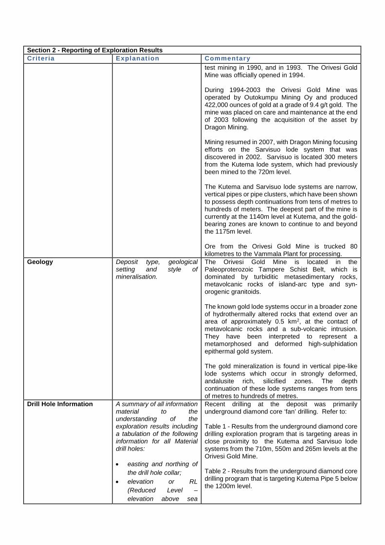
test mining in 1990, and in 1993. The Orivesi Gold Mine was officially opened in 1994. During 1994-2003 the Orivesi Gold Mine was operated by Outokumpu Mining Oy and produced 422,000 ounces of gold at a grade of 9.4 g/t gold. The mine was placed on care and maintenance at the end of 2003 following the acquisition of the asset by Dragon Mining. Mining resumed in 2007, with Dragon Mining focusing efforts on the Sarvisuo lode system that was discovered in 2002. Sarvisuo is located 300 meters from the Kutema lode system, which had previously been mined to the 720m level. The Kutema and Sarvisuo lode systems are narrow, vertical pipes or pipe clusters, which have been shown to possess depth continuations from tens of metres to hundreds of meters. The deepest part of the mine is currently at the 1140m level at Kutema, and the gold-bearing zones are known to continue to and beyond the 1175m level. Ore from the Orivesi Gold Mine is trucked 80 kilometres to the Vammala Plant for processing.
Geology Deposit type, geological setting and style of mineralisation.
The Orivesi Gold Mine is located in the Paleoproterozoic Tampere Schist Belt, which is dominated by turbiditic metasedimentary rocks, metavolcanic rocks of island-arc type and syn-orogenic granitoids. The known gold lode systems occur in a broader zone of hydrothermally altered rocks that extend over an area of approximately 0.5 km2, at the contact of metavolcanic rocks and a sub-volcanic intrusion. They have been interpreted to represent a metamorphosed and deformed high-sulphidation epithermal gold system. The gold mineralization is found in vertical pipe-like lode systems which occur in strongly deformed, andalusite rich, silicified zones. The depth continuation of these lode systems ranges from tens of metres to hundreds of metres.
Drill Hole Information A summary of all information material to the understanding of the exploration results including a tabulation of the following information for all Material drill holes: • easting and northing of
the drill hole collar; • elevation or RL
(Reduced Level – elevation above sea
Recent drilling at the deposit was primarily underground diamond core ‘fan’ drilling. Refer to: Table 1 - Results from the underground diamond core drilling exploration program that is targeting areas in close proximity to the Kutema and Sarvisuo lode systems from the 710m, 550m and 265m levels at the Orivesi Gold Mine. Table 2 - Results from the underground diamond core drilling program that is targeting Kutema Pipe 5 below the 1200m level.
Section 2 - Reporting of Exploration Results Criter ia Explanat ion Commentary
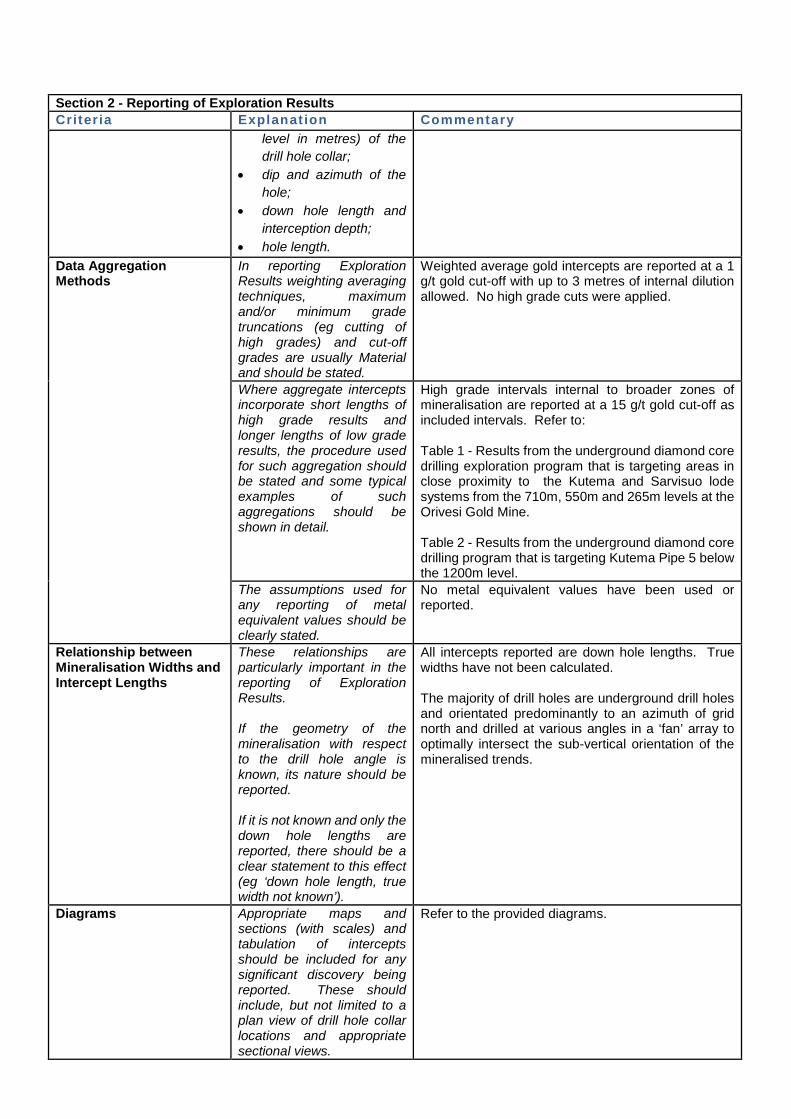
level in metres) of the drill hole collar;
• dip and azimuth of the hole;
• down hole length and interception depth;
• hole length. Data Aggregation Methods
In reporting Exploration Results weighting averaging techniques, maximum and/or minimum grade truncations (eg cutting of high grades) and cut-off grades are usually Material and should be stated.
Weighted average gold intercepts are reported at a 1 g/t gold cut-off with up to 3 metres of internal dilution allowed. No high grade cuts were applied.
Where aggregate intercepts incorporate short lengths of high grade results and longer lengths of low grade results, the procedure used for such aggregation should be stated and some typical examples of such aggregations should be shown in detail.
High grade intervals internal to broader zones of mineralisation are reported at a 15 g/t gold cut-off as included intervals. Refer to: Table 1 - Results from the underground diamond core drilling exploration program that is targeting areas in close proximity to the Kutema and Sarvisuo lode systems from the 710m, 550m and 265m levels at the Orivesi Gold Mine. Table 2 - Results from the underground diamond core drilling program that is targeting Kutema Pipe 5 below the 1200m level.
The assumptions used for any reporting of metal equivalent values should be clearly stated.
No metal equivalent values have been used or reported.
Relationship between Mineralisation Widths and Intercept Lengths
These relationships are particularly important in the reporting of Exploration Results. If the geometry of the mineralisation with respect to the drill hole angle is known, its nature should be reported. If it is not known and only the down hole lengths are reported, there should be a clear statement to this effect (eg ‘down hole length, true width not known’).
All intercepts reported are down hole lengths. True widths have not been calculated. The majority of drill holes are underground drill holes and orientated predominantly to an azimuth of grid north and drilled at various angles in a ‘fan’ array to optimally intersect the sub-vertical orientation of the mineralised trends.
Diagrams Appropriate maps and sections (with scales) and tabulation of intercepts should be included for any significant discovery being reported. These should include, but not limited to a plan view of drill hole collar locations and appropriate sectional views.
Refer to the provided diagrams.
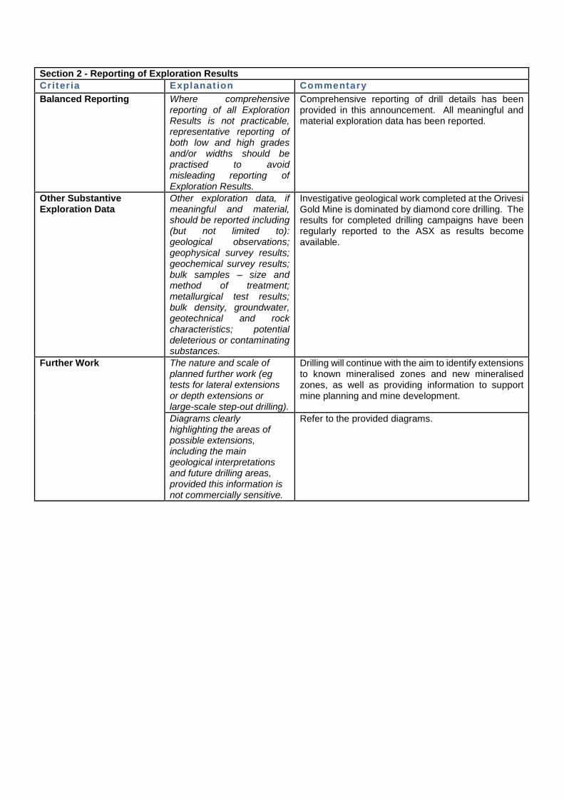
Section 2 - Reporting of Exploration Results Criter ia Explanat ion Commentary Balanced Reporting Where comprehensive
reporting of all Exploration Results is not practicable, representative reporting of both low and high grades and/or widths should be practised to avoid misleading reporting of Exploration Results.
Comprehensive reporting of drill details has been provided in this announcement. All meaningful and material exploration data has been reported.
Other Substantive Exploration Data
Other exploration data, if meaningful and material, should be reported including (but not limited to): geological observations; geophysical survey results; geochemical survey results; bulk samples – size and method of treatment; metallurgical test results; bulk density, groundwater, geotechnical and rock characteristics; potential deleterious or contaminating substances.
Investigative geological work completed at the Orivesi Gold Mine is dominated by diamond core drilling. The results for completed drilling campaigns have been regularly reported to the ASX as results become available.
Further Work The nature and scale of planned further work (eg tests for lateral extensions or depth extensions or large-scale step-out drilling).
Drilling will continue with the aim to identify extensions to known mineralised zones and new mineralised zones, as well as providing information to support mine planning and mine development.
Diagrams clearly highlighting the areas of possible extensions, including the main geological interpretations and future drilling areas, provided this information is not commercially sensitive.
Refer to the provided diagrams.
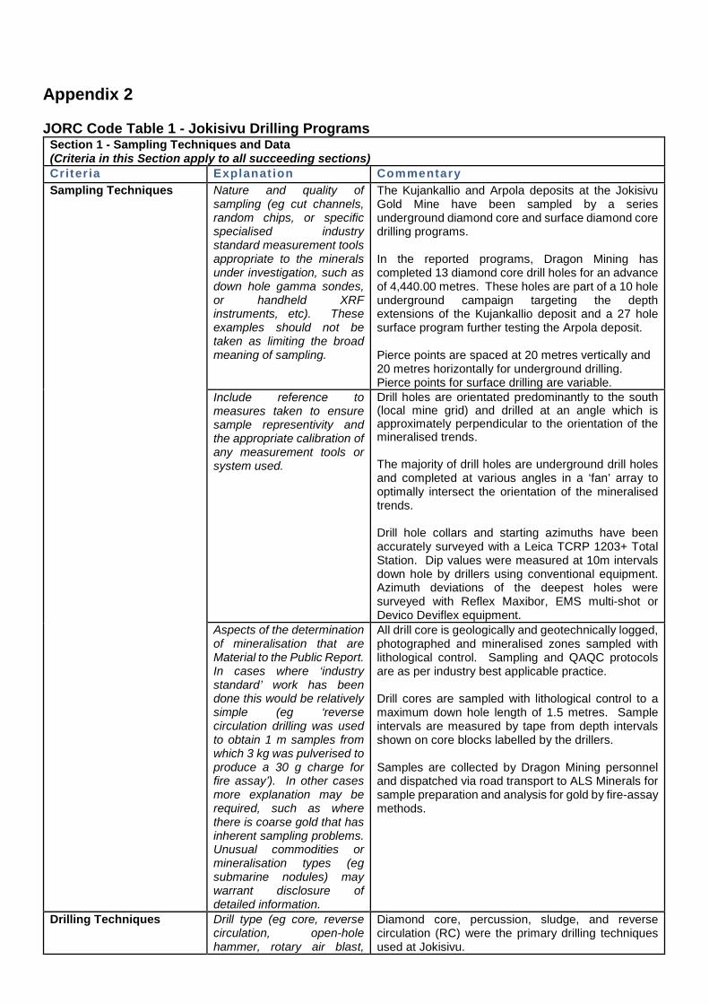
Appendix 2 JORC Code Table 1 - Jokisivu Drilling Programs
Section 1 - Sampling Techniques and Data (Criteria in this Section apply to all succeeding sections) Criteria Explanat ion Commentary Sampling Techniques Nature and quality of
sampling (eg cut channels, random chips, or specific specialised industry standard measurement tools appropriate to the minerals under investigation, such as down hole gamma sondes, or handheld XRF instruments, etc). These examples should not be taken as limiting the broad meaning of sampling.
The Kujankallio and Arpola deposits at the Jokisivu Gold Mine have been sampled by a series underground diamond core and surface diamond core drilling programs. In the reported programs, Dragon Mining has completed 13 diamond core drill holes for an advance of 4,440.00 metres. These holes are part of a 10 hole underground campaign targeting the depth extensions of the Kujankallio deposit and a 27 hole surface program further testing the Arpola deposit. Pierce points are spaced at 20 metres vertically and 20 metres horizontally for underground drilling. Pierce points for surface drilling are variable.
Include reference to measures taken to ensure sample representivity and the appropriate calibration of any measurement tools or system used.
Drill holes are orientated predominantly to the south (local mine grid) and drilled at an angle which is approximately perpendicular to the orientation of the mineralised trends. The majority of drill holes are underground drill holes and completed at various angles in a ‘fan’ array to optimally intersect the orientation of the mineralised trends. Drill hole collars and starting azimuths have been accurately surveyed with a Leica TCRP 1203+ Total Station. Dip values were measured at 10m intervals down hole by drillers using conventional equipment. Azimuth deviations of the deepest holes were surveyed with Reflex Maxibor, EMS multi-shot or Devico Deviflex equipment.
Aspects of the determination of mineralisation that are Material to the Public Report. In cases where ‘industry standard’ work has been done this would be relatively simple (eg ‘reverse circulation drilling was used to obtain 1 m samples from which 3 kg was pulverised to produce a 30 g charge for fire assay’). In other cases more explanation may be required, such as where there is coarse gold that has inherent sampling problems. Unusual commodities or mineralisation types (eg submarine nodules) may warrant disclosure of detailed information.
All drill core is geologically and geotechnically logged, photographed and mineralised zones sampled with lithological control. Sampling and QAQC protocols are as per industry best applicable practice. Drill cores are sampled with lithological control to a maximum down hole length of 1.5 metres. Sample intervals are measured by tape from depth intervals shown on core blocks labelled by the drillers. Samples are collected by Dragon Mining personnel and dispatched via road transport to ALS Minerals for sample preparation and analysis for gold by fire-assay methods.
Drilling Techniques Drill type (eg core, reverse circulation, open-hole hammer, rotary air blast,
Diamond core, percussion, sludge, and reverse circulation (RC) were the primary drilling techniques used at Jokisivu.
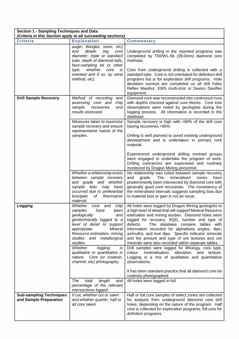
Section 1 - Sampling Techniques and Data (Criteria in this Section apply to all succeeding sections) Criteria Explanat ion Commentary
auger, Bangka, sonic, etc) and details (eg core diameter, triple or standard tube, depth of diamond tails, face-sampling bit or other type, whether core is oriented and if so, by what method, etc).
Underground drilling in the reported programs was completed by T56/WL-56 (39.0mm) diamond core methods. Core from underground drilling is collected with a standard tube. Core is not orientated for definition drill programs but is for exploration drill programs. Hole deviation surveys are completed on all drill holes Reflex Maxibor, EMS multi-shot or Devico Deviflex equipment. .
Drill Sample Recovery Method of recording and assessing core and chip sample recoveries and results assessed.
Diamond core was reconstructed into continuous runs with depths checked against core blocks. Core loss observations were noted by geologists during the logging process. All information is recorded in the database.
Measures taken to maximise sample recovery and ensure representative nature of the samples.
Sample recovery is high with >90% of the drill core having recoveries >95%. Drilling is well planned to avoid existing underground development and is undertaken in primary rock material. Experienced underground drilling contract groups were engaged to undertake the program of work. Drilling contractors are supervised and routinely monitored by Dragon Mining personnel.
Whether a relationship exists between sample recovery and grade and whether sample bias may have occurred due to preferential loss/gain of fine/coarse material.
No relationship was noted between sample recovery and grade. The mineralised zones have predominantly been intersected by diamond core with generally good core recoveries. The consistency of the mineralised intervals suggests sampling bias due to material loss or gain is not an issue.
Logging Whether core and chip samples have been geologically and geotechnically logged to a level of detail to support appropriate Mineral Resource estimation, mining studies and metallurgical studies.
All holes were logged by Dragon Mining geologists to a high level of detail that will support Mineral Resource estimation and mining studies. Diamond holes were logged for recovery, RQD, number and type of defects. The database contains tables with information recorded for alpha/beta angles, dips, azimuths, and true dips. Specific indicator minerals and the amount and type of ore textures and ore minerals were also recorded within separate tables.
Whether logging is qualitative or quantitative in nature. Core (or costean, channel, etc) photography.
Drill samples were logged for lithology, rock type, colour, mineralisation, alteration, and texture. Logging is a mix of qualitative and quantitative observations. It has been standard practice that all diamond core be routinely photographed.
The total length and percentage of the relevant intersections logged.
All holes were logged in full.
Sub-sampling Techniques and Sample Preparation
If cut, whether cut or sawn and whether quarter, half or all core taken.
Half or full core samples of select zones are collected for analysis from underground diamond core drill holes, depending on the nature of the program. Half core is collected for exploration programs, full core for definition programs.
Section 1 - Sampling Techniques and Data (Criteria in this Section apply to all succeeding sections) Criteria Explanat ion Commentary
Half or full core samples of select zones are collected for analysis from surface diamond core drill holes, depending on the nature of the program. Half core is collected for exploration programs, full core for definition programs. When core is required to be split it is sawn.
If non-core, whether riffled, tube sampled, rotary split, etc and whether sampled wet or dry.
Not applicable. All drilling is completed by diamond core methods.
For all sample types, the nature, quality and appropriateness of the sample preparation technique.
Full and half core samples of select zones were collected for analysis by company personnel. With respect to the nature of the mineralised system and the core diameter, the use of full or half core is considered the most appropriate. Sample preparation is completed by ALS Minerals and follows industry best applicable practice. ALS Minerals procedures and facilities are organised to assure proper preparation of the sample for analysis, to prevent sample mixing, and to minimise dust contamination or sample to sample contamination. Core samples are submitted to the ALS Minerals facility in Outokumpu, Finland for sample preparation by method PREP-31BY. Samples were weighed, assigned a unique bar code and logged into the ALS system. The sample was dried, fine crushed to >70% passing 2mm screen. A split off weighing 1kg is collected and pulverised to better than 85% passing 75 microns. A sub-sample is collected for analysis at the ALS Minerals facility at Rosia Montana, Romania. The method selected for sample preparation is considered appropriate.
Quality control procedures adopted for all sub-sampling stages to maximise representivity of samples.
Certified reference material and blanks are routinely inserted with the sample submission. Dragon has used systematic standard and pulp duplicate sampling since 2004. Every 20th sample (sample id ending in -00, -20, -40, -60, -80) is submitted as a standard, and every 20th sample (sample id ending in -10, -30, -50, -70, -90) is inserted as a pulp duplicate (with the original sample id ending in -09, -29, -49, -69, -89). A review of the results of the certified reference material and blanks indicates that they are within acceptable limits.
Measures taken to ensure that the sampling is representative of the in situ material collected including for instance results for field duplicate/second-half sampling.
Coarse crush duplicates are included in the sample stream every 20 samples. A review of the results of the duplicate samples indicates that they are within acceptable limits.
Whether sample sizes are appropriate to the grain size
Sample sizes are considered appropriate to correctly represent the moderately nuggetty gold mineralisation based on: the style of mineralisation, the thickness
Section 1 - Sampling Techniques and Data (Criteria in this Section apply to all succeeding sections) Criteria Explanat ion Commentary
of the material being sampled.
and consistency of the intersections, the sampling methodology and assay value ranges for gold.
Quality of Data and Laboratory Tests
The nature, quality and appropriateness of the assaying and laboratory procedures used and whether the technique is considered partial or total.
Analysis is completed at ALS Minerals in Rosia Montana, Romania using procedures Au-AA25 (Detection Limit – 0.01 g/t gold; Upper Limit – 100.00 g/t gold) – 30g fire assay with AAS finish. Gold values exceeding 3 g/t gold are re-assayed by Au-GRA21 (Detection Limit – 0.05 g/t gold; Upper Limit – 1,000.00 g/t gold) – 30g fire assay with gravimetric finish. ALS Minerals are a certified global laboratory group. They are monitored by an internal QAQC program and a QAQC program implemented by Dragon Mining, both of which include the inclusion of blank material, duplicates and certified reference material. The analytical techniques used are considered total.
For geophysical tools, spectrometers, handheld XRF instruments, etc, the parameters used in determining the analysis including instrument make and model, reading times, calibrations factors applied and their derivation, etc.
No such device was used for analytical purposes on sample material collected.
Nature and quality control procedures adopted (eg standards, blanks, duplicates, external laboratory checks) and whether acceptable levels of accuracy (ie lack of bias) and precision have been established.
QAQC protocols are stringently adhered to throughout the duration of all drilling programs undertaken by Dragon Mining. The protocols of the QAQC program implemented by Dragon Mining includes the insertion of certified reference material (three ranges used – high, medium and low) and blank material on a 1 sample every 20 sample basis and the insertion duplicate samples on a 1 sample every 20 sample basis. ALS Minerals implement an internal QAQC program that includes the insertion of blanks, certified reference material and duplicates with each analytical run. A review of both the Dragon Mining and ALS Minerals QAQC results indicates that the blank material, certified reference material and duplicates are within acceptable limits.
Verification of Sampling and Assaying
The verification of significant intersections by either independent or alternative company personnel.
All significant intercepts are reviewed and verified by Dragon Mining geologists.
The use of twinned holes. No twinned holes have been drilled. Documentation of primary data, data entry procedures, data verification, data storage (physical and electronic) protocols.
Primary data is collected by Dragon Mining personnel at the site using Drill Logger software. Primary assay data is received direct from the laboratory in digital format.
Section 1 - Sampling Techniques and Data (Criteria in this Section apply to all succeeding sections) Criteria Explanat ion Commentary
All measurements and observations are digitally recorded and transferred into an Access database. Primary assay and QAQC data is entered into an Oracle master database. Verification and validation of the databases is handled internally.
Discuss any adjustment to assay data.
No adjustment has been made to the assay data.
Location of Data Points Accuracy and quality of surveys used to locate drill holes (collar and down-hole surveys), trenches, mine workings and other locations used in Mineral Resource estimation.
Drill hole collars and starting azimuths have been accurately surveyed by various contract surveyors. Down hole surveys were undertaken on all exploration and resource development holes. Collars and underground mine surveys are performed using a Leica TCRP 1203+ Total Station to a level of accuracy of 0.05 metres. Down hole surveys are carried out on all drill holes using a Maxibor II, EMS multi-shot or Devico Deviflex device. Down hole dip values were recorded at 10m intervals.
Specification of the grid system used.
The grid system used for the reporting of results is the Finnish Grid System – KKJ2. A local mine grid is used at the Jokisivu mine. The local grid system is parallel to National Grid System, and equivalence of systems as follows (examples of coordinate values): NorthingNat 6,779,500.00 = NorthingLoc 9,500.00, EastingNat 2,425,800.00 = EastingLoc 5,800.00, ElevationNat 80.00 = ElevationLoc 0.00. NorthingLoc = NorthingNat – 6,770,000m EastingLoc = EastingNat – 2,420,000m ElevationLoc = ElevationNat – 80m
Quality and adequacy of topographic control.
A series of fixed points are located at the surface form the basis of all topographic control at the Jokisivu Gold Mine. Additional fixed points have been established along the underground development and function as the elevation control underground.
Data Spacing and Distribution
Data spacing for reporting of Exploration Results.
Underground drilling has been undertaken in a fan array type pattern. Pierce points are usually spaced nominally at 20 metres vertically and 20 metres horizontally. Surface drilling is completed on a nominal grid base. Pierce points are variable.
Whether the data spacing and distribution is sufficient to establish the degree of geological and grade continuity appropriate for the Mineral Resource and Ore Reserve estimation procedure(s) and classifications applied.
The geology and mineralisation displays satisfactory continuity in both geology and grade from hole to hole and will be sufficient to support the definition of a Mineral Resource or Ore Reserve and the classifications contained in the JORC Code (2012 Edition).
Whether sample compositing has been applied.
No sampling compositing has been applied.
Section 1 - Sampling Techniques and Data (Criteria in this Section apply to all succeeding sections) Criteria Explanat ion Commentary Orientation of Data in Relation to Geological Structure
Whether the orientation of sampling achieves unbiased sampling of possible structures and the extent to which this is known, considering the deposit type.
Drill holes are orientated predominantly to the south (local mine grid) and drilled at an angle which is approximately perpendicular to the orientation of the mineralised trends. The majority of drill holes are underground drill holes and completed at various angles in a ‘fan’ array to optimally intersect the orientation of the mineralised trends.
If the relationship between the drilling orientation and orientation of key mineralised structures is considered to have introduced a sampling bias, thus should be assessed and reported if material.
No orientation based sampling bias has been identified in the data.
Sample Security The measures taken to ensure sample security.
Chain of custody of samples is managed by Dragon Mining. Dragon Mining personnel or drill contractors transport diamond core to the core logging facilities where Dragon Mining geologists log the core. Core samples are transported to the sample preparation laboratory and then on to the analysis laboratory using contract couriers or laboratory personnel. Dragon Mining employees have no further involvement in the preparation or analysis of samples.
Audits or Reviews The results of any audits or reviews of sampling techniques and data.
Dragon Mining undertakes its own reviews and audits of sampling techniques and data. Dragon Mining has completed audits of the ALS Minerals facilities at Outokumpu, Finland; Rosia Montana, Romania and Vancouver, Canada. The completed reviews and audits raised no issues.
Section 2 - Reporting of Exploration Results Criter ia Explanat ion Commentary Mineral Tenement and Land Tenure Status
Type, reference name/number, location and ownership including agreements or material issues with third parties such as joint ventures, partnerships, overriding royalties, native title interests, historical sites, wilderness or national park and environmental settings.
The Jokisivu Gold Mine is located within a granted Mining Concession (Concession ID – 7244; Concession Name – Jokisivu; Area – 48.57 ha).
The security of the tenure held at the time off reporting along with any known impediments to obtaining a licence to operate in the area.
The Mining Concession is in good standing and no impediments to operating exist.
Exploration Completed by Other Parties
Acknowledgement and appraisal of exploration by other parties.
The first indication of gold mineralization in the Jokisivu area was obtained in 1964, when a local youth sent a gold-bearing boulder to an ore prospecting competition.
Section 2 - Reporting of Exploration Results Criter ia Explanat ion Commentary
Outokumpu Oy began exploring the area in 1985 and continued until 2003, when Dragon Mining acquired the Project. Dragon Mining advanced the project over the ensuing years, undertaking extensive drilling and completing mining studies to enable production to commence in 2009. Production from the Jokisivu Gold Mine commenced with open-pit mining of the near surface portion of the Kujankallio deposit in September 2009. The open pit has a span of 300 metres and attained a maximum depth of 45 metres. The near surface portion of the Arpola deposit was also mined by open-pit methods in 2011. The Arpola open-pit spanned a distance of 130 meters and was 30 meters deep. The Arpola open-pit has subsequently been re-filled with waste rock. Underground development of the Kujankallio deposit commenced in September 2010 access achieved through a decline portal located at the eastern most end of the Kujankallio open pit. Underground production from the Arpola deposit commenced in 2014.
Geology Deposit type, geological setting and style of mineralisation.
The Jokisivu Gold Mine is located in the Paleoproterozoic Vammala Migmatite Belt, which is dominated by tonalitic and granodioritic gneisses, micagneiss, migmatites, intermediate and mafic metamorphosed volcanic rocks as well as felsic and mafic plutonic rocks. Gold mineralisation is hosted within a sheared and quartz-veined diorite unit surrounded by mica gneiss. The Kujankallio deposit consists of several gold-bearing lodes, having a total length of at least 350 metres. The lodes strike northeast, primarily dipping 50 degrees to the southwest. The nearby Arpola deposit consists of several east-west trending gold lodes that extend over length of 150 metres. The Arpola lodes strike northeast and dip 50 degrees to the southwest. Both deposits represent structurally controlled gold systems.
Drill Hole Information A summary of all information material to the understanding of the exploration results including a tabulation of the following information for all Material drill holes: • easting and northing of
the drill hole collar; • elevation or RL
(Reduced Level – elevation above sea
Refer to the drill results in: Table 4 - Results from the underground diamond core drilling program that is targeting the Kujankallio deposit at the Jokisivu Gold Mine. Table 5 - Results from the surface diamond core drilling program that targeted the Arpola deposit at the Jokisivu Gold Mine. Table 3 - Results from the underground diamond core drilling exploration program that is targeting the plunge and dip extensions of the Kujankallio Hinge Zone at the Jokisivu Gold Mine.
Section 2 - Reporting of Exploration Results Criter ia Explanat ion Commentary
level in metres) of the drill hole collar;
• dip and azimuth of the hole;
• down hole length and interception depth;
• hole length. Data Aggregation Methods
In reporting Exploration Results weighting averaging techniques, maximum and/or minimum grade truncations (eg cutting of high grades) and cut-off grades are usually Material and should be stated.
Weighted average gold intercepts are reported at a 1 g/t gold cut-off with up to 2 metres of internal dilution allowed. No high grade cuts were applied.
Where aggregate intercepts incorporate short lengths of high grade results and longer lengths of low grade results, the procedure used for such aggregation should be stated and some typical examples of such aggregations should be shown in detail.
High grade intervals internal to broader zones of mineralisation are reported at a 15 g/t gold cut-off as included intervals. Refer to: Table 3 - Results from the underground diamond core drilling program that is targeting the Kujankallio deposit at the Jokisivu Gold Mine. Table 4 - Results from the surface diamond core drilling program that targeted the Arpola deposit at the Jokisivu Gold Mine. Table 5 - Results from the underground diamond core drilling exploration program that is targeting the plunge and dip extensions of the Kujankallio Hinge Zone at the Jokisivu Gold Mine.
The assumptions used for any reporting of metal equivalent values should be clearly stated.
No metal equivalent values have been used or reported.
Relationship between Mineralisation Widths and Intercept Lengths
These relationships are particularly important in the reporting of Exploration Results. If the geometry of the mineralisation with respect to the drill hole angle is known, its nature should be reported. If it is not known and only the down hole lengths are reported, there should be a clear statement to this effect (eg ‘down hole length, true width not known’).
All intercepts reported are down hole lengths. True widths have not been calculated.
At Arpola the drill holes were orientated predominantly to an azimuth of 180° (local mine grid) and angled to an average dip of approximately -50° which is approximately perpendicular to the orientation of the mineralised trends. The narrow mineralised zones strike at approximately 280° (local grid) and are variably dipping between 45° and 65° to the north (local grid). At Kujankallio the majority of drill holes were orientated predominantly to an azimuth of 198° (local mine grid) and angled to an average dip of approximately -60° which is approximately perpendicular to the orientation of the mineralised trends. The main Kujankallio lode strikes at approximately 280° (local grid) and dips at 40° to the north (local grid). Lodes within the ‘hinge zone’ strike approximately at 160° to 205° and dip to the east (local grid) at approximately 45°. Four lodes to the north-west strike at 015° and dip at 45° to the east.
Section 2 - Reporting of Exploration Results Criter ia Explanat ion Commentary Diagrams Appropriate maps and
sections (with scales) and tabulation of intercepts should be included for any significant discovery being reported. These should include, but not limited to a plan view of drill hole collar locations and appropriate sectional views.
Refer to provided diagrams.
Balanced Reporting Where comprehensive reporting of all Exploration Results is not practicable, representative reporting of both low and high grades and/or widths should be practised to avoid misleading reporting of Exploration Results.
Comprehensive reporting of drill details has been provided in this report. All meaningful and material exploration data has been reported.
Other Substantive Exploration Data
Other exploration data, if meaningful and material, should be reported including (but not limited to): geological observations; geophysical survey results; geochemical survey results; bulk samples – size and method of treatment; metallurgical test results; bulk density, groundwater, geotechnical and rock characteristics; potential deleterious or contaminating substances.
Investigative geological work completed at the Jokisivu Gold Mine is dominated by diamond core drilling. The results for completed drilling campaigns have been regularly reported to the ASX as results become available.
Further Work The nature and scale of planned further work (eg tests for lateral extensions or depth extensions or large-scale step-out drilling).
Drilling will continue with the aim to identify extensions to known mineralised zones and new mineralised zones, as well as providing information to support mine planning and development.
Diagrams clearly highlighting the areas of possible extensions, including the main geological interpretations and future drilling areas, provided this information is not commercially sensitive.
Refer to provided diagrams.