Embed Size (px)
Citation preview

ASX Announcement 18 October 2018
Group Resources Update
Highlights
• Group Mineral Resource Total now sits at 152.5Mt @ 8.5% for 13Mt of contained Graphite (Montepuez and Balama Central Projects).
• Montepuez Project Contained Graphite in the Mineral Resources grows by ~20% to 9.66Mt from the January 2017 estimate.
• Mineral Resources for Buffalo Deposit at Montepuez increased by 3.9mt to 42.6Mt, with a grade increase of 1.6% TGC to 9.5% TGC at a 2.5% TGC cut off.
• Buffalo Measured and Indicated Mineral Resources increased from 18.5Mt at 8.6% TGC to 22Mt at 10.0% TGC
• Mineral Resources for Elephant deposit at Montepuez increased by 14% to 76.9Mt at 7.3% TGC (see 16 July 2018 ASX announcement)
• Increased Mineral Resources expected to support an Updated Mine Plan for Montepuez targeting a circa +12% TGC feed grade to the Process Plant1.
1. See Montepuez Value Engineering Study Announcement “Restructure of Montepuez Graphite Project will revolutionise its economics” dated 18th October 2017
Battery Minerals Limited (ASX: BAT) is pleased to advise that its infill drilling programme at the Buffalo deposit within the Montepuez Project in Mozambique has both increased our resource base and confidence levels.
Detailed drilling and ongoing mining and metallurgical studies have also delivered an estimate for Buffalo with over 60% of the 42.6Mt in the Measured and Indicated Resource category. The Company is also pleased to announce an increase in the total resource grade from 7.9% TGC to 9.5% TGC at a 2.5% TGC cut off.
“The team have achieved a step change in the quantity and quality of our resource base. The increase in confidence in the overall Mineral Resources will be fed into the various mining studies and we look forward to the results.” Mr Flanagan said.
With 2018 seeing updates to Elephant, Buffalo and Balama Central Mineral Resources, we are pleased to report Group Mineral Resource Total of 152.2Mt at 8.5% TGC for 13.03Mt of contained Graphite.
These updated Mineral Resource estimates form the basis of the Montepuez Graphite project implementation mine plan and the Balama Central Feasibility Study mine plan, currently being prepared by Snowden. We look forward to reporting these results in early November 2018.
The updated Mineral Resource was estimated by independent mining consultants; Ashmore Advisory Pty Ltd (“Ashmore”).
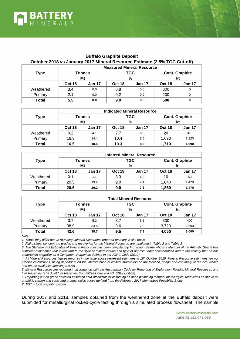
Buffalo Graphite Deposit
October 2018 vs January 2017 Mineral Resource Estimate (2.5% TGC Cut-off)
Measured Mineral Resource
Type Tonnes TGC Cont. Graphite
Mt % kt
Oct 18 Jan 17 Oct 18 Jan 17 Oct 18 Jan 17
Weathered 3.4 0.0 8.8 0.0 300 0
Primary 2.1 0.0 9.2 0.0 200 0
Total 5.5 0.0 9.0 0.0 500 0
Indicated Mineral Resource
Type Tonnes TGC Cont. Graphite
Mt % kt
Oct 18 Jan 17 Oct 18 Jan 17 Oct 18 Jan 17
Weathered 0.2 4.1 7.7 8.8 20 370
Primary 16.3 14.4 10.4 8.5 1,690 1,220
Total 16.5 18.5 10.3 8.6 1,710 1,590
Inferred Mineral Resource
Type Tonnes TGC Cont. Graphite
Mt % kt
Oct 18 Jan 17 Oct 18 Jan 17 Oct 18 Jan 17
Weathered 0.1 1.1 8.3 5.8 10 50
Primary 20.5 19.2 9.0 7.4 1,840 1,420
Total 20.6 20.2 9.0 7.3 1,850 1,470
Total Mineral Resource
Type Tonnes TGC Cont. Graphite
Mt % kt
Oct 18 Jan 17 Oct 18 Jan 17 Oct 18 Jan 17
Weathered 3.7 5.2 8.7 8.1 330 400
Primary 38.9 33.5 9.6 7.9 3,720 2,600
Total 42.6 38.7 9.5 7.9 4,050 3,000
Note: 1. Totals may differ due to rounding, Mineral Resources reported on a dry in-situ basis. 2. Flake sizes, concentrate grades and recoveries for the Mineral Resource are tabulated in Table 2 and Table 3. 3. The Statement of Estimates of Mineral Resources has been compiled by Mr. Shaun Searle who is a Member of the AIG. Mr. Searle has sufficient experience that is relevant to the style of mineralisation and type of deposit under consideration and to the activity that he has undertaken to qualify as a Competent Person as defined in the JORC Code (2012). 4. All Mineral Resources figures reported in the table above represent estimates at 18th October 2018. Mineral Resource estimates are not precise calculations, being dependent on the interpretation of limited information on the location, shape and continuity of the occurrence and on the available sampling results. 5. Mineral Resources are reported in accordance with the Australasian Code for Reporting of Exploration Results, Mineral Resources and Ore Reserves (The Joint Ore Reserves Committee Code – JORC 2012 Edition). 6. Reporting cut-off grade selected based on acut-off calculator assuming an open pit mining method, metallurgical recoveries as above for graphitic carbon and costs and product sales prices derived from the February 2017 Montepuez Feasibility Study. 7. TGC = total graphitic carbon
During 2017 and 2018, samples obtained from the weathered zone at the Buffalo deposit were submitted for metallurgical locked-cycle testing through a simulated process flowsheet. The sample

descriptions, flake distribution of product, concentrate grades and metallurgical recoveries are shown below.
Overall, high concentrate grades >96% TGC can be achieved for the weathered material type at almost 90% recovery. Further work is planned to refine the Buffalo primary flake size classification in the future.
Buffalo Weathered Simulated Product Flake Size Classification
Sieve Size (µm) % in Interval Cumulative %
>300 6.27 6.27
180-300 2.79 9.06
150-180 14.27 23.33
106-150 14.64 37.97
74-106 13.78 51.74
45-74 23.45 75.19
<45 24.81 100.00
Concentrate TGC% Met Rec %
97.0 89.3
Buffalo Primary Flake Size Classification
Sieve Size (µm) % in Interval Cumulative %
>300 9.3 9.3
180-300 20.1 29.4
106-180 30.7 60.1
38-106 39.9 100.0
Concentrate TGC% Met Rec %
96.0 76.9
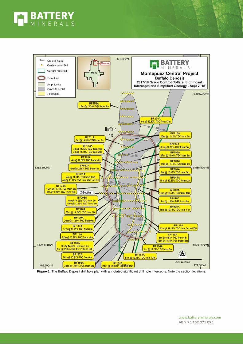
Figure 1: The Buffalo Deposit drill hole plan with annotated significant drill hole intercepts. Note the section locations.
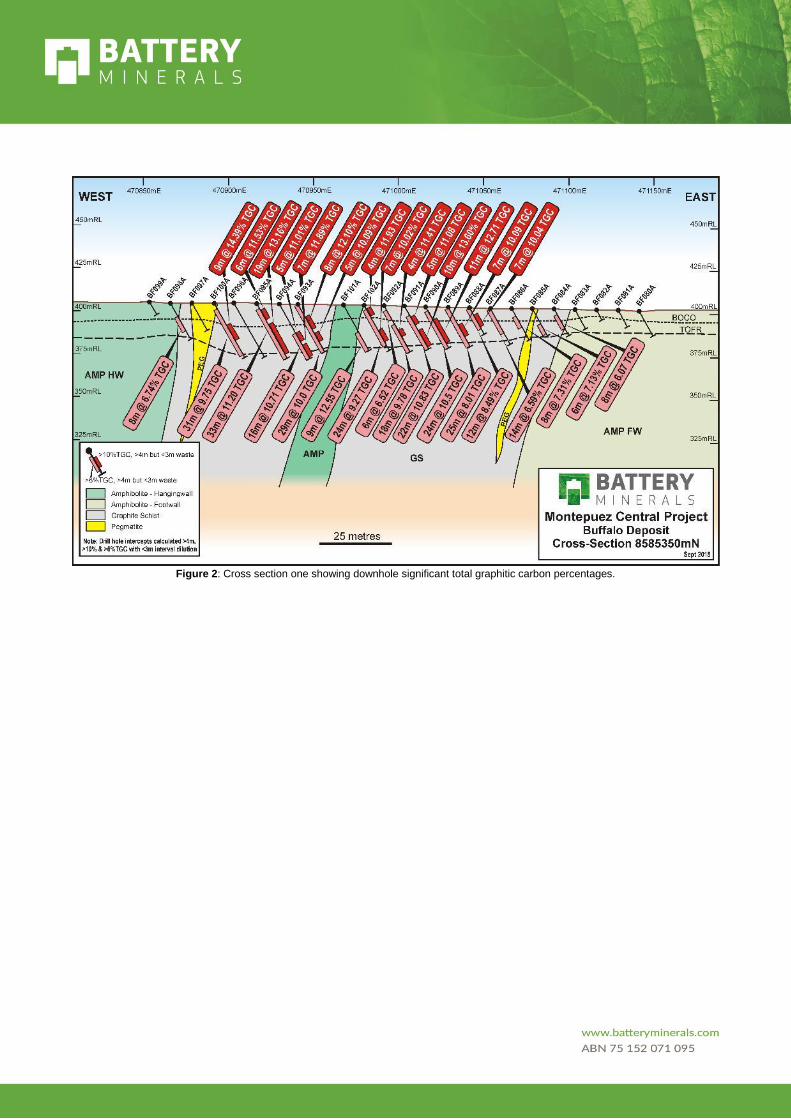
Figure 2: Cross section one showing downhole significant total graphitic carbon percentages.
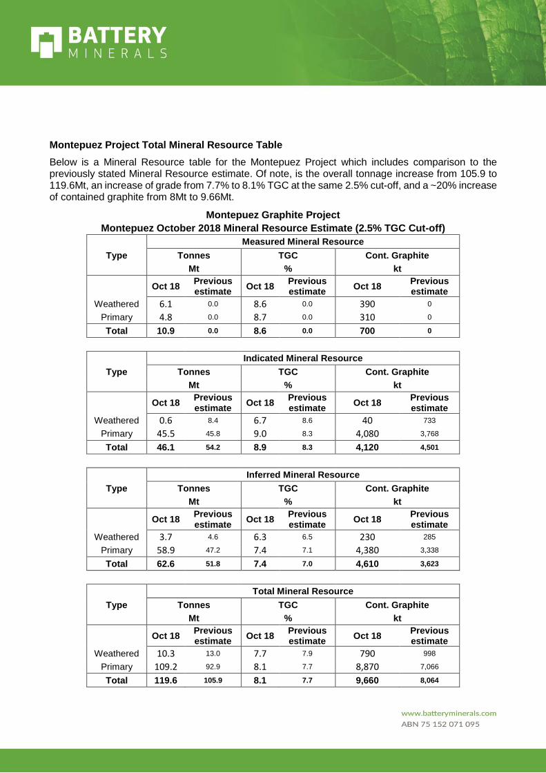
Montepuez Project Total Mineral Resource Table
Below is a Mineral Resource table for the Montepuez Project which includes comparison to the previously stated Mineral Resource estimate. Of note, is the overall tonnage increase from 105.9 to 119.6Mt, an increase of grade from 7.7% to 8.1% TGC at the same 2.5% cut-off, and a ~20% increase of contained graphite from 8Mt to 9.66Mt.
Montepuez Graphite Project
Montepuez October 2018 Mineral Resource Estimate (2.5% TGC Cut-off) Measured Mineral Resource
Type Tonnes TGC Cont. Graphite Mt % kt
Oct 18 Previous estimate
Oct 18 Previous estimate
Oct 18 Previous estimate
Weathered 6.1 0.0 8.6 0.0 390 0
Primary 4.8 0.0 8.7 0.0 310 0
Total 10.9 0.0 8.6 0.0 700 0
Indicated Mineral Resource
Type Tonnes TGC Cont. Graphite Mt % kt
Oct 18 Previous estimate
Oct 18 Previous estimate
Oct 18 Previous estimate
Weathered 0.6 8.4 6.7 8.6 40 733
Primary 45.5 45.8 9.0 8.3 4,080 3,768
Total 46.1 54.2 8.9 8.3 4,120 4,501
Inferred Mineral Resource
Type Tonnes TGC Cont. Graphite Mt % kt
Oct 18 Previous estimate
Oct 18 Previous estimate
Oct 18 Previous estimate
Weathered 3.7 4.6 6.3 6.5 230 285
Primary 58.9 47.2 7.4 7.1 4,380 3,338
Total 62.6 51.8 7.4 7.0 4,610 3,623
Total Mineral Resource
Type Tonnes TGC Cont. Graphite Mt % kt
Oct 18 Previous estimate
Oct 18 Previous estimate
Oct 18 Previous estimate
Weathered 10.3 13.0 7.7 7.9 790 998
Primary 109.2 92.9 8.1 7.7 8,870 7,066
Total 119.6 105.9 8.1 7.7 9,660 8,064
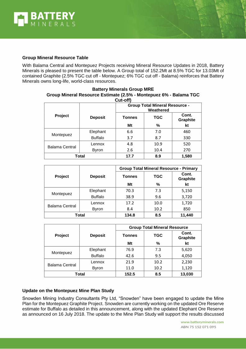
Group Mineral Resource Table
With Balama Central and Montepuez Projects receiving Mineral Resource Updates in 2018, Battery Minerals is pleased to present the table below. A Group total of 152.2Mt at 8.5% TGC for 13.03Mt of contained Graphite (2.5% TGC cut off - Montepuez; 6% TGC cut off - Balama) reinforces that Battery Minerals owns long-life, world-class resources.
Battery Minerals Group MRE
Group Mineral Resource Estimate (2.5% - Montepuez 6% - Balama TGC Cut-off)
Project
Group Total Mineral Resource - Weathered
Deposit Tonnes TGC Cont.
Graphite Mt % kt
Montepuez Elephant 6.6 7.0 460
Buffalo 3.7 8.7 330
Balama Central Lennox 4.8 10.9 520
Byron 2.6 10.4 270
Total 17.7 8.9 1,580
Project
Group Total Mineral Resource - Primary
Deposit Tonnes TGC Cont.
Graphite Mt % kt
Montepuez Elephant 70.3 7.3 5,150
Buffalo 38.9 9.6 3,720
Balama Central Lennox 17.2 10.0 1,720
Byron 8.4 10.2 850
Total 134.8 8.5 11,440
Project
Group Total Mineral Resource
Deposit Tonnes TGC Cont.
Graphite Mt % kt
Montepuez Elephant 76.9 7.3 5,620
Buffalo 42.6 9.5 4,050
Balama Central Lennox 21.9 10.2 2,230
Byron 11.0 10.2 1,120
Total 152.5 8.5 13,030
Update on the Montepuez Mine Plan Study
Snowden Mining Industry Consultants Pty Ltd, “Snowden” have been engaged to update the Mine Plan for the Montepuez Graphite Project. Snowden are currently working on the updated Ore Reserve estimate for Buffalo as detailed in this announcement, along with the updated Elephant Ore Reserve as announced on 16 July 2018. The update to the Mine Plan Study will support the results discussed

in the Montepuez Value Engineering Study Announcement “Restructure of Montepuez Graphite Project will revolutionise its economics” dated 18th October 2017. The updated Mine Plan is expected to be released in late October 2018.
Background Information on Battery Minerals
Battery Minerals Limited (“Battery Minerals”) is an ASX listed Australian company with two world-class graphite deposits in Mozambique, being Montepuez and Balama Central. Battery Minerals has produced high quality graphite flake concentrate at multiple laboratories. Subject to completing project financing, Battery Minerals intends to commence graphite flake concentrate production from its Montepuez Graphite Project at rates of 45,000 to 50,000tpa at an average flake concentrate grade of 96.7% TGC.
In December 2017 and January 2018, Battery Minerals signed four binding offtake agreements for up to 41,000tpa of graphite concentrate, representing over 80% of Montepuez’s forecast annual production. The Mozambican Government has granted Battery Minerals a Mining Licence and accepted the Company’s EIA for the Montepuez Graphite Project.
As Battery Minerals executes subsequent expansions, it expects production to grow to over 100,000 tonnes per annum graphite flake concentrate from its Montepuez Graphite Project.
Battery Minerals has also announced a scoping study on its Balama Central project, which comprises a Stage 1 production rate of 55,000tpa (B1) and Stage 2 rate of an additional ~55,000tpa (B2) for an aggregate of 110,000tpa from Balama. A final feasibility study is underway on Balama Central.
Combined with Montepuez and subject to continued positive economic, social and technical investigations, Balama Central provides scope for self-funded growth from a ~50,000tpa production-rate to more than 200,000tpa. (See ASX announcements dated 1st March 2018 and 29 March 2018 for full details, Scoping Study Cautionary Statement and Competent Persons statement on the Balama Central Graphite Project Scoping Study and Balama Central Resource Upgrade. All material assumptions underpinning the production target (as disclosed in these previous announcements) continue to apply and have not materially changed).

Investor Enquiries: Media Enquiries:
David Flanagan Managing Director, Battery Minerals Limited Tel: +61 8 6148 1000 Email: [email protected]
Paul Armstrong Read Corporate Tel: +61 8 9388 1474 Email: [email protected]
Tony Walsh Company Secretary, Battery Minerals Limited Tel: +61 408 289 476
Contact Details (Australian Office):
Ground Floor
10 Ord Street
West Perth, WA 6005
Australia
Competent Person’s Statement The Statement of Estimates of Mineral Resources has been compiled by Mr. Shaun Searle who is a Member of the AIG. Mr. Searle has sufficient experience that is relevant to the style of mineralisation and type of deposit under consideration and to the activity that he has undertaken to qualify as a Competent Person as defined in the JORC Code (2012). Mr Searle is a director of Ashmore Advisory Pty Ltd; an independent consultant to Battery Minerals Limited. Mr Searle consents to the inclusion in the report of the matters based on his information in the form and context in which it appears.
Important Notice This ASX Announcement does not constitute an offer to acquire or sell or a solicitation of an offer to sell or purchase any securities in any jurisdiction. In particular, this ASX Announcement does not constitute an offer, solicitation or sale to any U.S. person or in the United States or any state or jurisdiction in which such an offer, tender offer, solicitation or sale would be unlawful. The securities referred to herein have not been and will not be registered under the United States Securities Act of 1933, as amended (the “Securities Act”), and neither such securities nor any interest or participation therein may not be offered, or sold, pledged or otherwise transferred, directly or indirectly, in the United States or to any U.S. person absent registration or an available exemption from, or a transaction not subject to, registration under the United States Securities Act of 1933.
Forward Looking Statements Statements and material contained in this document, particularly those regarding possible or assumed future performance, resources or potential growth of Battery Minerals Limited, industry growth or other trend projections are, or may be, forward looking statements. Such statements relate to future events and expectations and, as such, involve known and unknown risks and uncertainties. Such forecasts and information are not a guarantee of future performance and involve unknown risk and uncertainties, as well as other factors, many of which are beyond the control of Battery Minerals Limited. Information in this presentation has already been reported to the ASX. All references to future production and production & shipping targets and port access made in relation to Battery Minerals are subject to the completion of all necessary feasibility studies, permit applications, construction, financing arrangements, port access and execution of infrastructure-related agreements. Where such a reference is made, it should be read subject to this paragraph and in conjunction with further information about the Mineral Resources and Ore Reserves, as well as the relevant competent persons' statements.

Figure 7: Montepuez Graphite Project location plan also showing location of the Battery Minerals Balama Graphite Project.
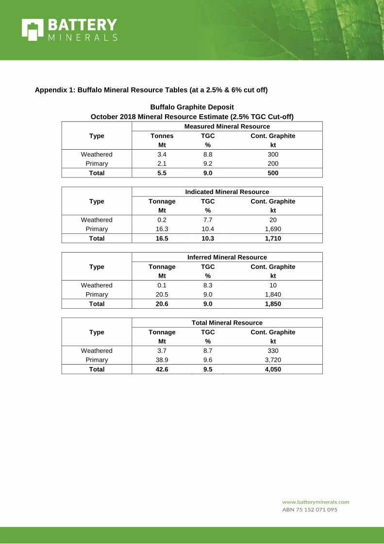
Appendix 1: Buffalo Mineral Resource Tables (at a 2.5% & 6% cut off)
Buffalo Graphite Deposit
October 2018 Mineral Resource Estimate (2.5% TGC Cut-off)
Measured Mineral Resource
Type Tonnes TGC Cont. Graphite
Mt % kt
Weathered 3.4 8.8 300
Primary 2.1 9.2 200
Total 5.5 9.0 500
Indicated Mineral Resource
Type Tonnage TGC Cont. Graphite
Mt % kt
Weathered 0.2 7.7 20
Primary 16.3 10.4 1,690
Total 16.5 10.3 1,710
Inferred Mineral Resource
Type Tonnage TGC Cont. Graphite
Mt % kt
Weathered 0.1 8.3 10
Primary 20.5 9.0 1,840
Total 20.6 9.0 1,850
Total Mineral Resource
Type Tonnage TGC Cont. Graphite
Mt % kt
Weathered 3.7 8.7 330
Primary 38.9 9.6 3,720
Total 42.6 9.5 4,050

Buffalo Graphite Deposit
October 2018 Mineral Resource Estimate (6% TGC Cut-off)
Measured Mineral Resource
Type Tonnes TGC Cont. Graphite
Mt % kt
Weathered 3.2 9.0 290
Primary 2.1 9.3 190
Total 5.3 9.1 480
Indicated Mineral Resource
Type Tonnage TGC Cont. Graphite
Mt % kt
Weathered 0.2 8.2 20
Primary 16.2 10.4 1,680
Total 16.4 10.4 1,700
Inferred Mineral Resource
Type Tonnage TGC Cont. Graphite
Mt % kt
Weathered 0.1 8.6 10
Primary 18.3 9.5 1,740
Total 18.4 9.5 1,740
Total Mineral Resource
Type Tonnage TGC Cont. Graphite
Mt % kt
Weathered 3.5 9.0 310
Primary 36.6 9.9 3,610
Total 40.1 9.8 3,920
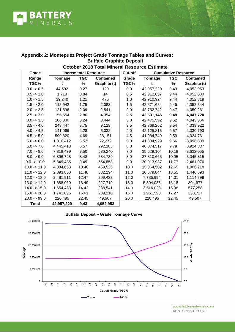
Appendix 2: Montepuez Project Grade Tonnage Tables and Curves:
Buffalo Graphite Deposit
October 2018 Total Mineral Resource Estimate
Grade Incremental Resource Cut-off Cumulative Resource
Range Tonnage TGC Contained Grade Tonnage TGC Contained
TGC% t % Graphite (t) TGC% t % Graphite (t)
0.0 -> 0.5 44,592 0.27 120 0.0 42,957,229 9.43 4,052,953
0.5 -> 1.0 1,713 0.84 14 0.5 42,912,637 9.44 4,052,833
1.0 -> 1.5 39,240 1.21 475 1.0 42,910,924 9.44 4,052,819
1.5 -> 2.0 118,942 1.75 2,083 1.5 42,871,684 9.45 4,052,344
2.0 -> 2.5 121,596 2.09 2,541 2.0 42,752,742 9.47 4,050,261
2.5 -> 3.0 155,554 2.80 4,354 2.5 42,631,146 9.49 4,047,720
3.0 -> 3.5 106,330 3.24 3,444 3.0 42,475,592 9.52 4,043,366
3.5 -> 4.0 243,447 3.75 9,129 3.5 42,369,262 9.54 4,039,922
4.0 -> 4.5 141,066 4.28 6,032 4.0 42,125,815 9.57 4,030,793
4.5 -> 5.0 599,820 4.69 28,151 4.5 41,984,749 9.59 4,024,761
5.0 -> 6.0 1,310,412 5.52 72,272 5.0 41,384,929 9.66 3,996,609
6.0 -> 7.0 4,445,413 6.57 292,283 6.0 40,074,517 9.79 3,924,337
7.0 -> 8.0 7,818,439 7.50 586,240 7.0 35,629,104 10.19 3,632,055
8.0 -> 9.0 6,896,728 8.48 584,739 8.0 27,810,665 10.95 3,045,815
9.0 -> 10.0 5,849,435 9.49 554,858 9.0 20,913,937 11.77 2,461,076
10.0 -> 11.0 4,384,658 10.48 459,525 10.0 15,064,502 12.65 1,906,218
11.0 -> 12.0 2,893,850 11.48 332,294 11.0 10,679,844 13.55 1,446,693
12.0 -> 13.0 2,481,911 12.47 309,422 12.0 7,785,994 14.31 1,114,399
13.0 -> 14.0 1,688,060 13.49 227,719 13.0 5,304,083 15.18 804,977
14.0 -> 15.0 1,654,433 14.42 238,541 14.0 3,616,023 15.96 577,258
15.0 -> 20.0 1,741,095 16.61 289,210 15.0 1,961,590 17.27 338,717
20.0 -> 99.0 220,495 22.45 49,507 20.0 220,495 22.45 49,507
Total 42,957,229 9.43 4,052,953
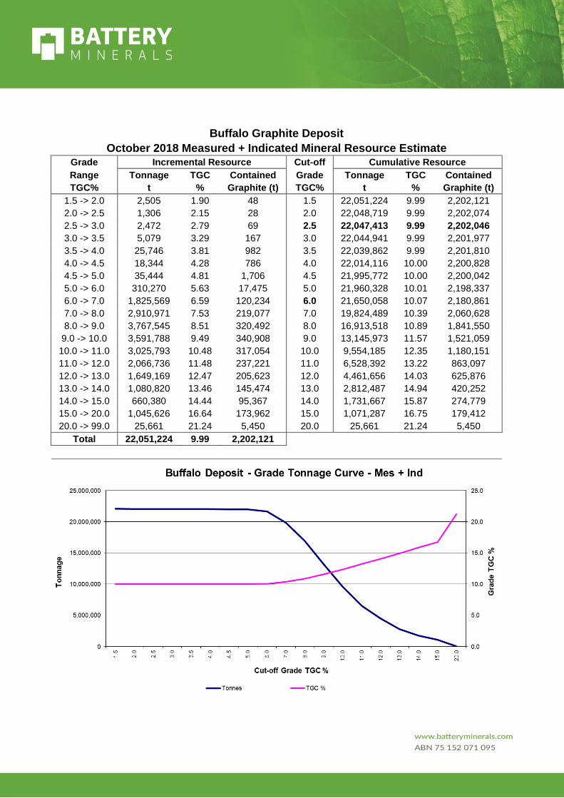
Buffalo Graphite Deposit
October 2018 Measured + Indicated Mineral Resource Estimate
Grade Incremental Resource Cut-off Cumulative Resource
Range Tonnage TGC Contained Grade Tonnage TGC Contained
TGC% t % Graphite (t) TGC% t % Graphite (t)
1.5 -> 2.0 2,505 1.90 48 1.5 22,051,224 9.99 2,202,121
2.0 -> 2.5 1,306 2.15 28 2.0 22,048,719 9.99 2,202,074
2.5 -> 3.0 2,472 2.79 69 2.5 22,047,413 9.99 2,202,046
3.0 -> 3.5 5,079 3.29 167 3.0 22,044,941 9.99 2,201,977
3.5 -> 4.0 25,746 3.81 982 3.5 22,039,862 9.99 2,201,810
4.0 -> 4.5 18,344 4.28 786 4.0 22,014,116 10.00 2,200,828
4.5 -> 5.0 35,444 4.81 1,706 4.5 21,995,772 10.00 2,200,042
5.0 -> 6.0 310,270 5.63 17,475 5.0 21,960,328 10.01 2,198,337
6.0 -> 7.0 1,825,569 6.59 120,234 6.0 21,650,058 10.07 2,180,861
7.0 -> 8.0 2,910,971 7.53 219,077 7.0 19,824,489 10.39 2,060,628
8.0 -> 9.0 3,767,545 8.51 320,492 8.0 16,913,518 10.89 1,841,550
9.0 -> 10.0 3,591,788 9.49 340,908 9.0 13,145,973 11.57 1,521,059
10.0 -> 11.0 3,025,793 10.48 317,054 10.0 9,554,185 12.35 1,180,151
11.0 -> 12.0 2,066,736 11.48 237,221 11.0 6,528,392 13.22 863,097
12.0 -> 13.0 1,649,169 12.47 205,623 12.0 4,461,656 14.03 625,876
13.0 -> 14.0 1,080,820 13.46 145,474 13.0 2,812,487 14.94 420,252
14.0 -> 15.0 660,380 14.44 95,367 14.0 1,731,667 15.87 274,779
15.0 -> 20.0 1,045,626 16.64 173,962 15.0 1,071,287 16.75 179,412
20.0 -> 99.0 25,661 21.24 5,450 20.0 25,661 21.24 5,450
Total 22,051,224 9.99 2,202,121

Appendix 3: Table 1 of JORC Code JORC Code, 2012 Edition Table 1 Appendix 3 to Announcement: Buffalo Resource Update Section 1 Sampling Techniques and Data
Criteria JORC Code explanation Commentary
Sampling
techniques • Nature and quality of sampling (e.g. cut channels,
random chips, or specific specialised industry
standard measurement tools appropriate to the
minerals under investigation, such as down hole
gamma sondes, or handheld XRF instruments, etc).
These examples should not be taken as limiting the
broad meaning of sampling.
• Include reference to measures taken to ensure
sample representivity and the appropriate
calibration of any measurement tools or systems
used.
• Aspects of the determination of mineralisation that
are Material to the Public Report. In cases where
‘industry standard’ work has been done this would
be relatively simple (e.g. ‘reverse circulation
drilling was used to obtain 1 m samples from which
3 kg was pulverised to produce a 30 g charge for
fire assay’). In other cases more explanation may
be required, such as where there is coarse gold that
has inherent sampling problems. Unusual
commodities or mineralisation types (e.g.
submarine nodules) may warrant disclosure of
detailed information.
The entire RC hole was sampled and assayed at
1m intervals.
Internal logging procedures and processes ensure
that sample representivity is maintained
throughout the entire process.
During logging, a visual estimation of graphite
content is used to base the lithology, along with
other indicator minerals. However, all samples
were collected at a nominal 2 to 3kg size and
submitted for analysis via the LECO analyser.
Drilling
techniques • Drill type (e.g. core, reverse circulation, open-hole
hammer, rotary air blast, auger, Bangka, sonic,
etc) and details (e.g. core diameter, triple or
standard tube, depth of diamond tails, face-
sampling bit or other type, whether core is oriented
and if so, by what method, etc).
The RC drilling was undertaken using a SHRAM RC
rig with Metzke rig mounted cone splitter. A nominal
4.5 inch blade bit was used to achieve drilling
penetration instead of a normal hammer bit. The entire
RC hole was sampled and assayed at 1m intervals.
Drill sample
recovery • Method of recording and assessing core and chip
sample recoveries and results assessed.
• Measures taken to maximise sample recovery and
ensure representative nature of the samples.
• Whether a relationship exists between sample
recovery and grade and whether sample bias may
have occurred due to preferential loss/gain of
fine/coarse material.
Sieved RC chip samples were collected and geologically logged and grade estimates (Visual Graphite Estimates).
The driller was instructed and supervised to ensure that maximum sample recovery is to be obtained, issues were reported immediately and remedial action taken to find a solution in difficult drilling conditions.
The RC samples were assessed for moisture and weight at the rig with data recorded in the database.
No bias was observed between sample size and grade determined.
Logging • Whether core and chip samples have been
geologically and geotechnically logged to a level of
detail to support appropriate Mineral Resource
estimation, mining studies and metallurgical
studies.
• Whether logging is qualitative or quantitative in
nature. Core (or costean, channel, etc)
Drill holes were logged by trained and experienced geologists and the level of detail would support a Mineral Resource estimation and subsequent classification.

Criteria JORC Code explanation Commentary
photography.
• The total length and percentage of the relevant
intersections logged.
Geological logging of all drill cuttings included; weathering, lithology, colour, mineralogy, mineralisation and visual graphite estimates.
All data is initially captured on paper logging sheets and transferred to locked excel format tables for validation and is then loaded into the parent access database. All diamond drill core has been photographed and archived, firstly after mark-up and secondly after sampling. The logging and reporting of visual graphite percentages on preliminary logs is semi-quantitative and not absolute.
Sub-sampling
techniques and
sample
preparation
• If core, whether cut or sawn and whether quarter,
half or all core taken.
• If non-core, whether riffled, tube sampled, rotary
split, etc and whether sampled wet or dry.
• For all sample types, the nature, quality and
appropriateness of the sample preparation
technique.
• Quality control procedures adopted for all sub-
sampling stages to maximise representivity of
samples.
• Measures taken to ensure that the sampling is
representative of the in situ material collected,
including for instance results for field
duplicate/second-half sampling.
• Whether sample sizes are appropriate to the grain
size of the material being sampled.
All samples were drilled dry and split through the
cone splitter with a duplicate sample
collected at the drill rig.
The sampling undertaken to date is appropriate for
grade control purposes and geological interpretation.
Samples were submitted to the ALS Minerals facility
in Johannesburg, South Africa for sample preparation
and analysis. Samples were weighed, assigned a
unique bar code and logged into the ALS system. The
entire sample was oven dried at 105˚ and crushed to -
2mm. A 300g sub-sample of the crushed material was
then pulverised to better than 85% passing -75µm
using a LM5 pulveriser. The pulverised sample was
split with multiple feed in a Jones riffle splitter until a
100-200g sub-sample was obtained.
Quality of assay
data and
laboratory tests
• The nature, quality and appropriateness of the
assaying and laboratory procedures used and
whether the technique is considered partial or
total.
• For geophysical tools, spectrometers, handheld
XRF instruments, etc, the parameters used in
determining the analysis including instrument
make and model, reading times, calibrations
factors applied and their derivation, etc.
• Nature of quality control procedures adopted (e.g.
standards, blanks, duplicates, external laboratory
checks) and whether acceptable levels of accuracy
(i.e. lack of bias) and precision have been
established.
Loss on Ignition (LOI) has been determined between
105° and 1,050°C. Results are reported on a dry
sample basis.
Analysis includes Total Graphitic Carbon by LECO.
The detection limits and precision for the Total
Graphitic Carbon (TGC) analysis are considered
adequate for resource estimation.
All laboratory batch QC measures are checked for bias
before final entry in the database, no bias has been
identified in the results received.
The CRM TGC values range between 4-24%. The
blank samples comprise 1-2kg of dolomitic marble
quarried from a location 50km east of the Elephant
Central project.
Six CRM’s (GGC001, GGC003, GGC004, GGC005,
GGC006 and GGC010) were used to monitor
graphitic carbon.
Verification of
sampling and
assaying
• The verification of significant intersections by
either independent or alternative company
personnel.
• The use of twinned holes.
• Documentation of primary data, data entry
procedures, data verification, data storage
(physical and electronic) protocols.
Significant intersections were visually field verified
and inspected by Jason Livingstone during his visits in
2018.
No twinned drill holes have been drilled on the project
to date however no sampling bias is believed to exist
due to quality triple tube core recovery. Q-Q analysis

Criteria JORC Code explanation Commentary
• Discuss any adjustment to assay data. of the RC versus DD drilling indicates that there is no
discernible bias between the two drill methods.
Location of data
points • Accuracy and quality of surveys used to locate drill
holes (collar and down-hole surveys), trenches,
mine workings and other locations used in Mineral
Resource estimation.
• Specification of the grid system used.
• Quality and adequacy of topographic control.
All spatial data across the Project was collected in
WGS84 UTM Zone 37 South datum.
Planned drill holes were surveyed using Garmin 62s
GPS devices which typically have a ±5m error in the
project area.
Final collar locations were surveyed by
GEOSURVEY utilising a differential GPS system
with 0.02cm accuracy.
Fresh satellite capture (30cm panchromatic standard 2A WorldView-3 stero orthoimagery) was used to produce a 0.5m contour digital survey model. Drill hole collars were used as control points in producing the digital contours.
Data spacing
and distribution • Data spacing for reporting of Exploration Results.
• Whether the data spacing and distribution is
sufficient to establish the degree of geological and
grade continuity appropriate for the Mineral
Resource and Ore Reserve estimation procedure(s)
and classifications applied.
• Whether sample compositing has been applied.
BAT’s graphite prospects adopt drill line spacing on 400m and 200m spaced lines with 50m hole spacing on section. Additional grade control spaced drilling has been conducted within the weathered portions of the deposit at 50m by 12.5m spacings. This drill hole spacing is believed appropriate in which to assist in classifying Mineral Resources.
Orientation of
data in relation
to geological
structure
• Whether the orientation of sampling achieves
unbiased sampling of possible structures and the
extent to which this is known, considering the
deposit type.
• If the relationship between the drilling orientation
and the orientation of key mineralised structures is
considered to have introduced a sampling bias, this
should be assessed and reported if material.
Reconnaissance geological mapping and pitting was conducted prior to drilling the prospect in 2015. Mapping and pitting identified the regional stratigraphic southwest-northeast trend and moderate (-50°-70° towards northwest) dipping rocks. Drill orientation was designed accordingly to limit potential bias.
The drilling is considered to have no significant sampling bias relative to geological structure orientation.
Sample security • The measures taken to ensure sample security. The samples are stored in the company’s field base
until laboratory dispatch. Samples are shipped by
courier to ALS – Johannesburg, South Africa for
sample preparation and analysis.
Any visible signs of tampering are reported by the
laboratory and none have been reported to date.
Audits or
reviews • The results of any audits or reviews of sampling
techniques and data.
Shaun Searle of RPM reviewed drilling and sampling procedures during the 2015 site visit and found that procedures and practices conform to industry standards

Section 2 Reporting of Exploration Results
Criteria JORC Code explanation Commentary
Mineral tenement and land
tenure status • Type, reference name/number, location and
ownership including agreements or material
issues with third parties such as joint
ventures, partnerships, overriding royalties,
native title interests, historical sites,
wilderness or national park and
environmental settings.
• The security of the tenure held at the time of
reporting along with any known impediments
to obtaining a license to operate in the area.
The Montepuez Project 8770C Mining License comprises an area covering 3,666.88ha and is held 100% by Battery Minerals Limited (Metals of Africa Limited prior to December 2016) via a locally owned subsidiary Suni Resources SA.
The Montepuez Project contains the Elephant, Buffalo and Lion deposits however resource and reserve estimations were limited to Elephant and Buffalo during the DFS.
All statutory approvals have been acquired to conduct development activities and the Company has established a good working relationship with the government departments of Mozambique and continues to build its relationship with the local community.
The company is not aware of any impediments relating to the licenses or area.
The Company has completed its field
investigations as part of the Environmental
Impact Assessment which has subsequently
been approved by the regulatory body of
Mozambique.
The reference to Exploration Results in this
announcement are activities that will contribute
towards the estimation of a mineral resources
and in turn a reserve determination and
feasibility studies, let alone potential or actual
mining activities. However, in accordance with
Mozambican Law, whilst Battery Minerals via
Suni Resources, hold the mining rights over the
8770C tenure for Graphite and Vanadium,
“Exploration Results” by definition of the JORC
2012 Code are being discussed, however the
work performed and reported is in support of
the scheduled mining and processing operations
planned for the 8770C Mining Licence.
Exploration done by other
parties • Acknowledgment and appraisal of
exploration by other parties.
The Project area has been mapped at 1:250,000 scale as part of a nation-wide geological study prepared by a consortium funded by the Nordic Development Fund. The project area has also been flown with regionally spaced airborne geophysics (magnetics and radiometrics) as part of a post war government investment initiative.

There is no record of past direct exploration activities on the license that BAT has knowledge of.
A portion of the Montepuez Project was flown
with VTEM by a neighbouring license holder
and BAT flew its own survey in 2015.
Geology • Deposit type, geological setting and style of
mineralisation.
The deposits were discovered after drill testing a series of coincident VTEM conductors and prospective stratigraphy with mapped graphitic outcrop occurrences.
The 8770C license occurs on the Xixano Complex and traverse the tectonic contacts between the Nairoto, Xixano and Montepuez Complexes. The Xixano Complex includes a variety of metasupracrustal rocks enveloping predominantly mafic igneous rocks and granulites that form the core of a regional north-northeast to south-southwest-trending synform. The paragneisses include mica gneiss and schist, quartzfeldspar gneiss, metasandstone, quartzite and marble.
The metamorphic grade in the paragneiss is dominantly amphibolite facies, although granulite facies rocks occur locally in the region. The oldest dated rock in the Xixano Complex is a weakly deformed meta-rhyolite which is interlayed in the meta-supracrustal rocks and which gives a reliable extrusion age of 818 +/- 10 Ma.
Graphite-bearing mica schist and gneiss are found in different tectonic complexes in the Cabo Delgado Province of Mozambique.
Local geology comprises dolerite, meta-sediments, amphibolites, psammite with graphitic metasediments and graphitic schists.
At Elephant deposit the metamorphic banding and foliation strike about 005° and the GSQF dips moderately steep west.
At Buffalo the deformation strained zone of GSQF, psammite and amphibolite exhibit brittle and brittle-ductile structures that intersect each other, the deformation zone is where graphite mineralisation is located and part of a regional metamorphic and deformation event.
The Montepuez deposits are disseminated with graphite dispersed within gneiss. The graphite forms as a result of high grade metamorphism of organic carbonaceous matter, the protolith in which the graphite has

formed may have been globular carbon, composite flakes, homogenous flakes or crystalline graphite.
Drill hole information • A summary of all information material to the
under-standing of the exploration results
including a tabulation of the following
information for all Material drill holes:
• easting and northing of the drill hole
collar
• elevation or RL (Reduced Level –
elevation above sea level in metres) of the
drill hole collar
• dip and azimuth of the hole
• down hole length and interception depth
• hole length
• If the exclusion of this information is justified
on the basis that the information is not
Material and this exclusion does not detract
from the understanding of the report, the
Competent Person should clearly explain why
this is the case.
All exploration results have previously been reported by MTA/ BAT between 2015 and 2018.
All drill hole information has been included in
Appendix 2 of this report. No drill hole
information has been excluded.
Data aggregation methods • In reporting Exploration Results, weighting
averaging techniques, maximum and/or
minimum grade truncations (e.g. cutting of
high grades) and cut-off grades are usually
Material and should be stated.
• Where aggregate intercepts incorporate
short lengths of high grade results and
longer lengths of low grade results, the
procedure used for such aggregation should
be stated and some typical examples of such
aggregations should be shown in detail.
• The assumptions used for any reporting of
metal equivalent values should be clearly
stated.
Drill hole intercepts are calculated using two sets of parameters:
The first to highlight the higher grading intercepts are zones greater than 4 metres down hole that are greater than 10% TGC but overall, include no more than 3 metres of continuous less than 10% TGC material.
The second to highlight the previously stated MRE cut off of 6% grading intercepts are zones greater than 4 metres down hole that are greater than 6% TGC but overall, include no more than 3 metres of continuous less than 6% TGC material. However, this is only used in the cross section to illustrate continuity.
Metal equivalent values have not been used.
Relationship between
mineralisation widths and
intercept lengths
• These relationships are particularly important in the reporting of Exploration Results.
• If the geometry of the mineralisation with respect to the drill hole angle is known, its nature should be reported.
• If it is not known and only the down hole lengths are reported, there should be a clear statement to this effect (e.g. ‘down hole length, true width not known’).
The geology at Elephant is less structurally complex than Buffalo and comprises a moderately steep westerly graphitic schist package bound by amphibolite and notable psammite in the southern portion of the
orebody.
Diagrams • Appropriate maps and sections (with scales)
and tabulations of intercepts should be
included for any significant discovery being
reported. These should include, but not be
limited to a plan view of drill hole collar
locations and appropriate sectional views.
Relevant diagrams have been included within the main body of text
Section 3 Estimation and Reporting of Mineral Resources
Criteria JORC Code explanation Commentary
Database
integrity • Measures taken to ensure that data has not been
corrupted by, for example, transcription or keying
errors, between its initial collection and its use for
Mineral Resource estimation purposes.
• Data validation procedures used.
Geological and field data is collected using customised Excel logging sheets on tablet computers. The data is verified by company geologists before the data is imported into an Access database.
Ashmore performed initial data audits in Surpac. Ashmore checked collar coordinates, hole depths, hole dips, assay data overlaps and duplicate records. Minor errors were found, documented and amended.
Site visits • Comment on any site visits undertaken by the
Competent Person and the outcome of those visits.
• If no site visits have been undertaken indicate why
this is the case.
A site visit was conducted by, Shaun Searle of Ashmore during June 2015. Shaun inspected the deposit area, drill core, outcrop and the core logging and sampling facility.
Balanced Reporting • Accuracy and quality of surveys used to
locate drill holes (collar and down-hole
surveys), trenches, mine workings and other
locations used in Mineral Resource
estimation.
• Where comprehensive reporting of all
Exploration Results is not practicable,
representative reporting of both low and high
grades and/or widths should be practiced to
avoid misleading reporting of Exploration
Results.
The report is believed to include all representative and relevant information and is believed to be comprehensive.
Other substantive
exploration data • Other exploration data, if meaningful and
material, should be reported including (but
not limited to): geological observations;
geophysical survey results; geochemical
survey results; bulk samples - size and method
of treatment; metallurgical test results; bulk
density, groundwater, geotechnical and rock
characteristics; potential deleterious or
contaminating substances.
Regional airborne geophysical (magnetics, radiometrics), DEM and regional geological mapping was used to assist mapping interpretation and drill hole targeting.
Subsequent to mapping, VTEM data was acquired and contributed to the surface geology interpretation.
Metallurgical sample was sourced from surface
trenches as well as drill core sample selected
from fresh and oxidised horizons dispersed over
the Elephant and Buffalo orebodies.
Metallurgical samples were selected by
lithology and TGC%. The samples are
considered representative of the orebody.
Further work • The nature and scale of planned further work
(e.g. tests for lateral extensions or depth
extensions or large- scale step-out drilling).
• Diagrams clearly highlighting the areas of
possible extensions, including the main
geological interpretations and future drilling
areas, provided this information is not
commercially sensitive.
Further drilling to increase the size and/or confidence in the Mineral Resource will be conducted.
Further metallurgical, geotechnical and hydrogeological drilling is planned.

Criteria JORC Code explanation Commentary
During this time, notes and photos were taken. Discussions were held with site personnel regarding drilling and sampling procedures. No major issues were encountered.
Geological
interpretation • Confidence in (or conversely, the uncertainty of)
the geological interpretation of the mineral
deposit.
• Nature of the data used and of any assumptions
made.
• The effect, if any, of alternative interpretations on
Mineral Resource estimation.
• The use of geology in guiding and controlling
Mineral Resource estimation.
• The factors affecting continuity both of grade and
geology.
The confidence in the geological interpretation is considered to be good and is based on visual confirmation in outcrop. Geochemistry and geological logging has been used to assist identification of lithology and mineralisation.
The Mineralisation at the Buffalo deposit has been structurally thickened by local parasitic folding and is considered to be structurally complex; with an overall synclinal structure. Infill drilling has supported and refined the model and the current interpretation is considered robust. Outcrops of mineralisation and host rocks confirm the geometry of the mineralisation. Infill drilling has confirmed geological and grade continuity.
Dimensions • The extent and variability of the Mineral Resource
expressed as length (along strike or otherwise),
plan width, and depth below surface to the upper
and lower limits of the Mineral Resource.
The Buffalo Mineral Resource area extends over a north-south strike length of 900m (from 8,585,065mN – 8,585,965mN), has a maximum width of 295m (470,855mE – 471,150mE) and includes the 280m vertical interval from 410mRL to 130mRL.
Estimation and
modelling
techniques
• The nature and appropriateness of the estimation
technique(s) applied and key assumptions,
including treatment of extreme grade values,
domaining, interpolation parameters and
maximum distance of extrapolation from data
points. If a computer assisted estimation method
was chosen include a description of computer
software and parameters used.
• The availability of check estimates, previous
estimates and/or mine production records and
whether the Mineral Resource estimate takes
appropriate account of such data.
• The assumptions made regarding recovery of by-
products.
• Estimation of deleterious elements or other non-
grade variables of economic significance (e.g.
sulphur for acid mine drainage characterisation).
• In the case of block model interpolation, the block
size in relation to the average sample spacing and
the search employed.
• Any assumptions behind modelling of selective
mining units.
• Any assumptions about correlation between
variables.
• Description of how the geological interpretation
was used to control the resource estimates.
• Discussion of basis for using or not using grade
cutting or capping.
• The process of validation, the checking process
used, the comparison of model data to drill hole
Using parameters derived from modelled variograms, Ordinary Kriging (OK) was used to estimate average block grades in three passes using Surpac software. Linear grade estimation was deemed suitable for the Buffalo Mineral Resource due to the geological controls on mineralisation.
Maximum extrapolation of wireframes from drilling was 100m along strike and 50m down-dip. This was half drill hole spacing in this region of the Project. Maximum extrapolation was generally half drill hole spacing.
Reconciliation could not be conducted due to the absence of mining.
No recovery of by-products is anticipated.
In addition to graphitic carbon (TGC), V2O5, S, TiO2 and LOI were interpolated into the block model. Flake size was not estimated into the block model but was averaged for characterisation of the Mineral Resource.
The parent block dimensions used were 25m NS by 5m EW by 2.5m vertical with sub-cells of 3.125m by 1.25m by 1.25m. The parent block size was selected on the basis of kriging neighbourhood analysis, while dimensions in other directions were selected to provide sufficient resolution to the

Criteria JORC Code explanation Commentary
data, and use of reconciliation data if available. block model in the across-strike and down-dip direction.
An orientated ‘ellipsoid’ search was used to select data and adjusted to account for the variations in lode orientations, however all other parameters were taken from the variography derived from Domain 1. Three passes were used for each domain. For the domains with grade control spaced drilling, the first pass had a range of 50m, with a minimum of six samples. For the second pass, the range was extended to 200m, with a minimum of six samples. For the final pass, the range was extended to 400m, with a minimum of four samples. For all other domains, the first pass had a range of 200m, with a minimum of six samples. For the second pass, the range was extended to 400m, with a minimum of four samples. For the final pass, the range was extended to 600m, with a minimum of two samples. A maximum of 16 samples was used for all three passes.
No assumptions were made on selective mining units.
TGC had a strong positive correlation with V2O5 and LOI. V2O5 and LOI also had a strong positive correlation. Remaining pairs had no correlations or weak negative correlations.
The estimate was constrained by geology outlines based on logged geology, with some consideration of TGC grade. The main mineralised unit (denoted ‘gs’ in the lithology attribute) consisted of logged GSQF, GS1 and GS2 lithologies. Internal, lower grade zones were also domained where amphibolite was logged (denoted ‘amp’ in the lithology attribute). The country rock is amphibolite and is waste material. TGC, V2O5, S, LOI and TiO2 grades were estimated into the ‘gs’ and ‘amp’ blocks, although only the ‘gs’ material was classified as Mineral Resource. Geological logging was used to create weathering wireframes.
In addition, the raw assays for the Deposit were imported into Supervisor software to assist with determining an appropriate wireframe cut-off grade. Breaks were noted at 2% and 2.5% TGC, therefore a lower wireframe cut-off of 2.5% TGC was selected as a lower grade cut-off for wireframing. A minimum down-hole length of 4m was used with no edge dilution and some zones of internal dilution were included to maintain continuity of the wireframes. The wireframes were applied as hard boundaries in the estimate.
Statistical analysis was carried out on data from six mineralised domains and eight waste domains.
Criteria JORC Code explanation Commentary
After analysis, it was determined that no top-cuts were required.
Validation of the model included detailed comparison of composite grades and block grades by northing and elevation. Validation plots showed good correlation between the composite grades and the block model grades.
Moisture • Whether the tonnages are estimated on a dry basis
or with natural moisture, and the method of
determination of the moisture content.
Tonnages and grades were estimated on a dry in situ basis.
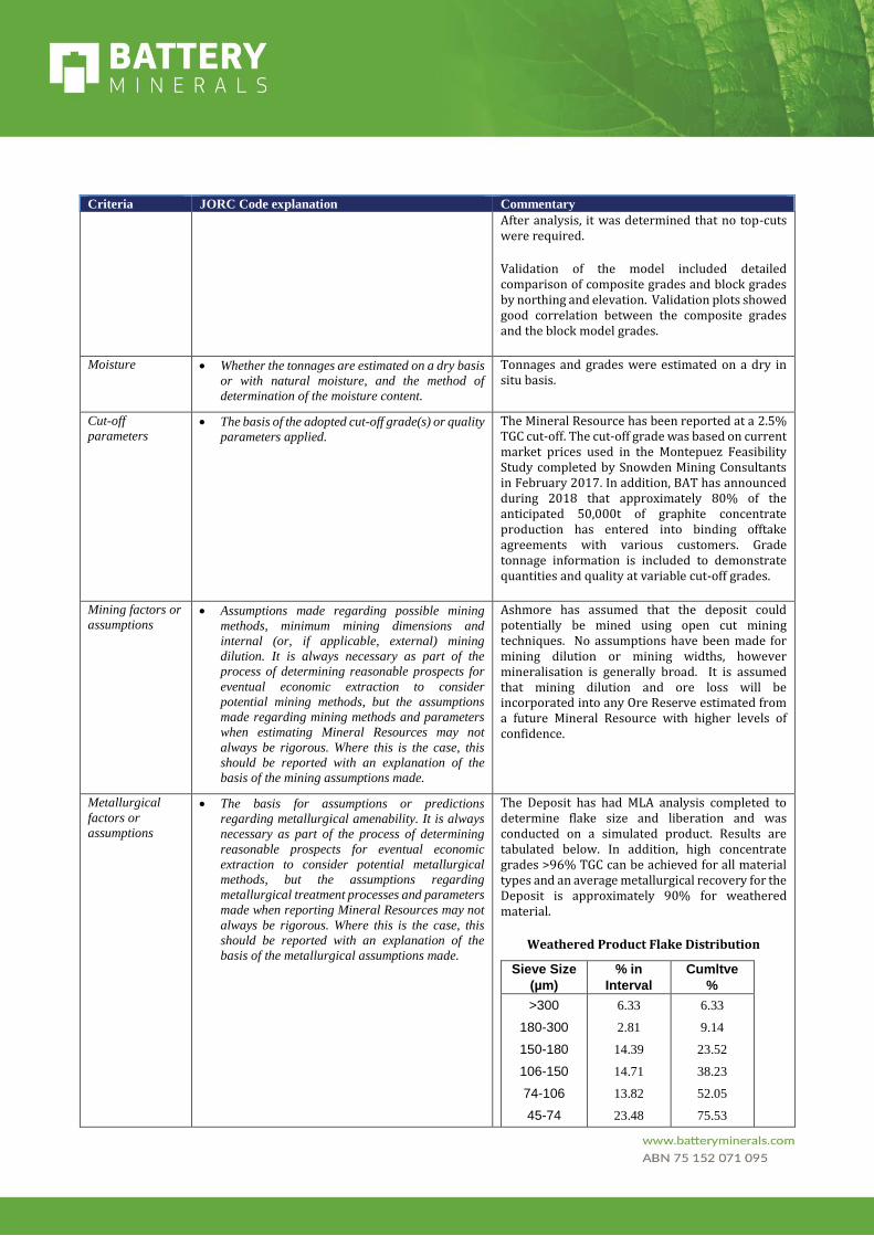
Cut-off
parameters • The basis of the adopted cut-off grade(s) or quality
parameters applied.
The Mineral Resource has been reported at a 2.5% TGC cut-off. The cut-off grade was based on current market prices used in the Montepuez Feasibility Study completed by Snowden Mining Consultants in February 2017. In addition, BAT has announced during 2018 that approximately 80% of the anticipated 50,000t of graphite concentrate production has entered into binding offtake agreements with various customers. Grade tonnage information is included to demonstrate quantities and quality at variable cut-off grades.
Mining factors or
assumptions • Assumptions made regarding possible mining
methods, minimum mining dimensions and
internal (or, if applicable, external) mining
dilution. It is always necessary as part of the
process of determining reasonable prospects for
eventual economic extraction to consider
potential mining methods, but the assumptions
made regarding mining methods and parameters
when estimating Mineral Resources may not
always be rigorous. Where this is the case, this
should be reported with an explanation of the
basis of the mining assumptions made.
Ashmore has assumed that the deposit could potentially be mined using open cut mining techniques. No assumptions have been made for mining dilution or mining widths, however mineralisation is generally broad. It is assumed that mining dilution and ore loss will be incorporated into any Ore Reserve estimated from a future Mineral Resource with higher levels of confidence.
Metallurgical
factors or
assumptions
• The basis for assumptions or predictions
regarding metallurgical amenability. It is always
necessary as part of the process of determining
reasonable prospects for eventual economic
extraction to consider potential metallurgical
methods, but the assumptions regarding
metallurgical treatment processes and parameters
made when reporting Mineral Resources may not
always be rigorous. Where this is the case, this
should be reported with an explanation of the
basis of the metallurgical assumptions made.
The Deposit has had MLA analysis completed to determine flake size and liberation and was conducted on a simulated product. Results are tabulated below. In addition, high concentrate grades >96% TGC can be achieved for all material types and an average metallurgical recovery for the Deposit is approximately 90% for weathered material.
Weathered Product Flake Distribution
Sieve Size
(µm)
% in
Interval
Cumltve
%
>300 6.33 6.33
180-300 2.81 9.14
150-180 14.39 23.52
106-150 14.71 38.23
74-106 13.82 52.05
45-74 23.48 75.53

Criteria JORC Code explanation Commentary
<45 24.47 100.00
Environmental
factors or
assumptions
• Assumptions made regarding possible waste and
process residue disposal options. It is always
necessary as part of the process of determining
reasonable prospects for eventual economic
extraction to consider the potential environmental
impacts of the mining and processing operation.
While at this stage the determination of potential
environmental impacts, particularly for a
greenfields project, may not always be well
advanced, the status of early consideration of
these potential environmental impacts should be
reported. Where these aspects have not been
considered this should be reported with an
explanation of the environmental assumptions
made.
No assumptions have been made regarding environmental factors. BAT will work to mitigate environmental impacts as a result of any future mining or mineral processing.
Bulk density • Whether assumed or determined. If assumed, the
basis for the assumptions. If determined, the
method used, whether wet or dry, the frequency of
the measurements, the nature, size and
representativeness of the samples.
• The bulk density for bulk material must have been
measured by methods that adequately account for
void spaces (vugs, porosity, etc), moisture and
differences between rock and alteration zones
within the deposit.
• Discuss assumptions for bulk density estimates
used in the evaluation process of the different
materials.
Various bulk densities have been assigned in the block model based on weathering and mineralisation. These densities were determined after averaging the density measurements obtained from diamond core.
Bulk density was measured using the water immersion technique. Moisture is accounted for in the measuring process. A total of 1,484 bulk density measurements were obtained from core drilled at the Project.
It is assumed that the bulk density will have little variation within the separate material types across the breadth of the project area.
Classification • The basis for the classification of the Mineral
Resources into varying confidence categories.
• Whether appropriate account has been taken of all
relevant factors (ie relative confidence in
tonnage/grade estimations, reliability of input
data, confidence in continuity of geology and
metal values, quality, quantity and distribution of
the data).
• Whether the result appropriately reflects the
Competent Person’s view of the deposit.
The Mineral Resource estimate is reported here in compliance with the 2012 Edition of the ‘Australasian Code for Reporting of Exploration Results, Mineral Resources and Ore Reserves’ by the Joint Ore Reserves Committee (JORC). The Mineral Resource was classified as Measured, Indicated and Inferred Mineral Resource based on data quality, sample spacing, and lode continuity. The Measured Mineral Resource was defined in areas of close spaced RC and DD drilling of 50m by 12.5m and confined to material above the top of fresh rock. The Indicated Mineral Resource was defined within areas of close spaced diamond drilling of less than 200m by 50m, and where the continuity and predictability of the lode positions was good. The Inferred Mineral Resource was assigned to areas where drill hole spacing was greater than 200m by 50m, where small isolated pods of mineralisation occur outside the main mineralised zones, and to geologically complex zones.
The input data is comprehensive in its coverage of the mineralisation and does not favour or misrepresent in-situ mineralisation. The definition of mineralised zones is based on high level

Criteria JORC Code explanation Commentary
geological understanding producing a robust model of mineralised domains. Validation of the block model shows good correlation of the input data to the estimated grades.
The Mineral Resource estimate appropriately reflects the view of the Competent Person.
Audits or reviews • The results of any audits or reviews of Mineral
Resource estimates.
Internal audits have been completed by Ashmore which verified the technical inputs, methodology, parameters and results of the estimate.
Discussion of
relative accuracy/
confidence
• Where appropriate a statement of the relative
accuracy and confidence level in the Mineral
Resource estimate using an approach or
procedure deemed appropriate by the Competent
Person. For example, the application of statistical
or geostatistical procedures to quantify the
relative accuracy of the resource within stated
confidence limits, or, if such an approach is not
deemed appropriate, a qualitative discussion of
the factors that could affect the relative accuracy
and confidence of the estimate.
• The statement should specify whether it relates to
global or local estimates, and, if local, state the
relevant tonnages, which should be relevant to
technical and economic evaluation.
Documentation should include assumptions made
and the procedures used.
• These statements of relative accuracy and
confidence of the estimate should be compared
with production data, where available.
The lode geometry and continuity has been adequately interpreted to reflect the applied level of Measured, Indicated and Inferred Mineral Resource. The data quality is good and the drill holes have detailed logs produced by qualified geologists. A recognised laboratory has been used for all analyses.
The Mineral Resource statement relates to global estimates of tonnes and grade.
Reconciliation could not be conducted as no mining has occurred at the deposit.
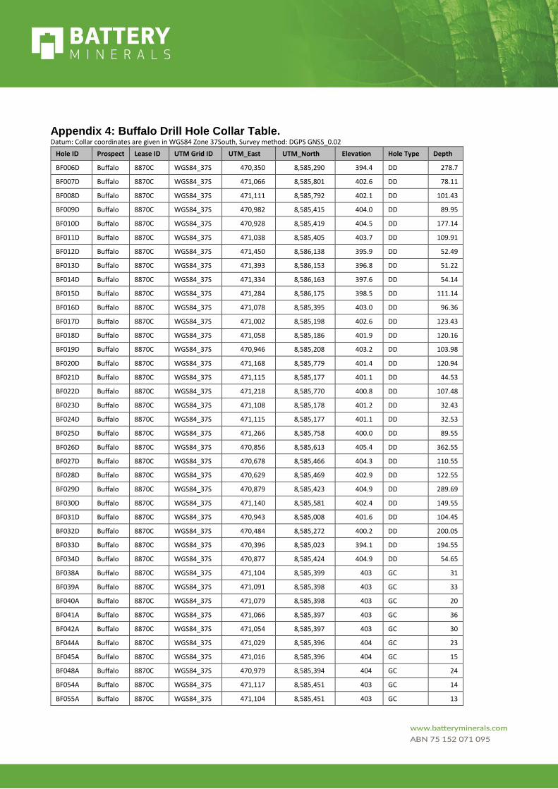
Appendix 4: Buffalo Drill Hole Collar Table. Datum: Collar coordinates are given in WGS84 Zone 37South, Survey method: DGPS GNSS_0.02
Hole ID Prospect Lease ID UTM Grid ID UTM_East UTM_North Elevation Hole Type Depth
BF006D Buffalo 8870C WGS84_37S 470,350 8,585,290 394.4 DD 278.7
BF007D Buffalo 8870C WGS84_37S 471,066 8,585,801 402.6 DD 78.11
BF008D Buffalo 8870C WGS84_37S 471,111 8,585,792 402.1 DD 101.43
BF009D Buffalo 8870C WGS84_37S 470,982 8,585,415 404.0 DD 89.95
BF010D Buffalo 8870C WGS84_37S 470,928 8,585,419 404.5 DD 177.14
BF011D Buffalo 8870C WGS84_37S 471,038 8,585,405 403.7 DD 109.91
BF012D Buffalo 8870C WGS84_37S 471,450 8,586,138 395.9 DD 52.49
BF013D Buffalo 8870C WGS84_37S 471,393 8,586,153 396.8 DD 51.22
BF014D Buffalo 8870C WGS84_37S 471,334 8,586,163 397.6 DD 54.14
BF015D Buffalo 8870C WGS84_37S 471,284 8,586,175 398.5 DD 111.14
BF016D Buffalo 8870C WGS84_37S 471,078 8,585,395 403.0 DD 96.36
BF017D Buffalo 8870C WGS84_37S 471,002 8,585,198 402.6 DD 123.43
BF018D Buffalo 8870C WGS84_37S 471,058 8,585,186 401.9 DD 120.16
BF019D Buffalo 8870C WGS84_37S 470,946 8,585,208 403.2 DD 103.98
BF020D Buffalo 8870C WGS84_37S 471,168 8,585,779 401.4 DD 120.94
BF021D Buffalo 8870C WGS84_37S 471,115 8,585,177 401.1 DD 44.53
BF022D Buffalo 8870C WGS84_37S 471,218 8,585,770 400.8 DD 107.48
BF023D Buffalo 8870C WGS84_37S 471,108 8,585,178 401.2 DD 32.43
BF024D Buffalo 8870C WGS84_37S 471,115 8,585,177 401.1 DD 32.53
BF025D Buffalo 8870C WGS84_37S 471,266 8,585,758 400.0 DD 89.55
BF026D Buffalo 8870C WGS84_37S 470,856 8,585,613 405.4 DD 362.55
BF027D Buffalo 8870C WGS84_37S 470,678 8,585,466 404.3 DD 110.55
BF028D Buffalo 8870C WGS84_37S 470,629 8,585,469 402.9 DD 122.55
BF029D Buffalo 8870C WGS84_37S 470,879 8,585,423 404.9 DD 289.69
BF030D Buffalo 8870C WGS84_37S 471,140 8,585,581 402.4 DD 149.55
BF031D Buffalo 8870C WGS84_37S 470,943 8,585,008 401.6 DD 104.45
BF032D Buffalo 8870C WGS84_37S 470,484 8,585,272 400.2 DD 200.05
BF033D Buffalo 8870C WGS84_37S 470,396 8,585,023 394.1 DD 194.55
BF034D Buffalo 8870C WGS84_37S 470,877 8,585,424 404.9 DD 54.65
BF038A Buffalo 8870C WGS84_37S 471,104 8,585,399 403 GC 31
BF039A Buffalo 8870C WGS84_37S 471,091 8,585,398 403 GC 33
BF040A Buffalo 8870C WGS84_37S 471,079 8,585,398 403 GC 20
BF041A Buffalo 8870C WGS84_37S 471,066 8,585,397 403 GC 36
BF042A Buffalo 8870C WGS84_37S 471,054 8,585,397 403 GC 30
BF044A Buffalo 8870C WGS84_37S 471,029 8,585,396 404 GC 23
BF045A Buffalo 8870C WGS84_37S 471,016 8,585,396 404 GC 15
BF048A Buffalo 8870C WGS84_37S 470,979 8,585,394 404 GC 24
BF054A Buffalo 8870C WGS84_37S 471,117 8,585,451 403 GC 14
BF055A Buffalo 8870C WGS84_37S 471,104 8,585,451 403 GC 13

Hole ID Prospect Lease ID UTM Grid ID UTM_East UTM_North Elevation Hole Type Depth
BF058A Buffalo 8870C WGS84_37S 471,067 8,585,450 403 GC 28
BF059A Buffalo 8870C WGS84_37S 471,054 8,585,450 404 GC 18
BF062A Buffalo 8870C WGS84_37S 471,004 8,585,450 404 GC 13
BF071A Buffalo 8870C WGS84_37S 470,891 8,585,447 405 GC 30
BF076A Buffalo 8870C WGS84_37S 470,904 8,585,391 405 GC 27
BF078A Buffalo 8870C WGS84_37S 470,879 8,585,391 405 GC 24
BF079A Buffalo 8870C WGS84_37S 470,867 8,585,390 405 GC 26
BF088A Buffalo 8870C WGS84_37S 471,042 8,585,346 403 GC 18
BF089A Buffalo 8870C WGS84_37S 471,029 8,585,346 403 GC 26
BF090A Buffalo 8870C WGS84_37S 471,016 8,585,347 404 GC 27
BF091A Buffalo 8870C WGS84_37S 471,004 8,585,346 404 GC 28
BF092A Buffalo 8870C WGS84_37S 470,992 8,585,344 404 GC 31
BF093A Buffalo 8870C WGS84_37S 470,941 8,585,345 404 GC 31
BF094A Buffalo 8870C WGS84_37S 470,930 8,585,345 404 GC 36
BF095A Buffalo 8870C WGS84_37S 470,917 8,585,345 404 GC 36
BF100A Buffalo 8870C WGS84_37S 470,892 8,585,347 405 GC 36
BF102A Buffalo 8870C WGS84_37S 470,980 8,585,346 404 GC 30
BF111A Buffalo 8870C WGS84_37S 471,053 8,585,298 403 GC 30
BF112A Buffalo 8870C WGS84_37S 471,040 8,585,298 403 GC 30
BF113A Buffalo 8870C WGS84_37S 471,027 8,585,298 403 GC 36
BF114A Buffalo 8870C WGS84_37S 471,015 8,585,298 403 GC 18
BF115A Buffalo 8870C WGS84_37S 470,990 8,585,297 403 GC 36
BF116A Buffalo 8870C WGS84_37S 471,003 8,585,294 403 GC 36
BF117A Buffalo 8870C WGS84_37S 470,978 8,585,296 404 GC 36
BF118A Buffalo 8870C WGS84_37S 470,966 8,585,296 404 GC 36
BF119A Buffalo 8870C WGS84_37S 470,953 8,585,295 404 GC 31
BF120A Buffalo 8870C WGS84_37S 470,941 8,585,295 404 GC 36
BF125A Buffalo 8870C WGS84_37S 471,091 8,585,249 402 GC 30
BF126A Buffalo 8870C WGS84_37S 471,078 8,585,248 402 GC 36
BF127A Buffalo 8870C WGS84_37S 471,066 8,585,248 402 GC 36
BF129A Buffalo 8870C WGS84_37S 471,028 8,585,248 403 GC 18
BF130A Buffalo 8870C WGS84_37S 471,015 8,585,248 403 GC 18
BF131A Buffalo 8870C WGS84_37S 471,002 8,585,247 403 GC 13
BF132A Buffalo 8870C WGS84_37S 470,991 8,585,247 403 GC 23
BF134A Buffalo 8870C WGS84_37S 470,965 8,585,247 403 GC 24
BF138A Buffalo 8870C WGS84_37S 471,118 8,585,199 401 GC 29
BF139A Buffalo 8870C WGS84_37S 471,106 8,585,199 401 GC 34
BF140A Buffalo 8870C WGS84_37S 471,092 8,585,199 401 GC 36
BF144A Buffalo 8870C WGS84_37S 471,044 8,585,199 402 GC 18
BF152A Buffalo 8870C WGS84_37S 471,016 8,585,210 403 GC 18
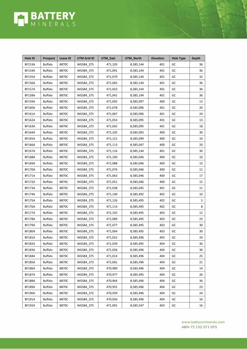
Hole ID Prospect Lease ID UTM Grid ID UTM_East UTM_North Elevation Hole Type Depth
BF153A Buffalo 8870C WGS84_37S 471,103 8,585,144 401 GC 36
BF154A Buffalo 8870C WGS84_37S 471,091 8,585,144 401 GC 36
BF155A Buffalo 8870C WGS84_37S 471,079 8,585,144 401 GC 32
BF156A Buffalo 8870C WGS84_37S 471,065 8,585,144 401 GC 36
BF157A Buffalo 8870C WGS84_37S 471,053 8,585,144 401 GC 36
BF158A Buffalo 8870C WGS84_37S 471,041 8,585,144 401 GC 36
BF159A Buffalo 8870C WGS84_37S 471,092 8,585,097 400 GC 13
BF160A Buffalo 8870C WGS84_37S 471,078 8,585,096 401 GC 20
BF161A Buffalo 8870C WGS84_37S 471,067 8,585,096 401 GC 24
BF162A Buffalo 8870C WGS84_37S 471,054 8,585,095 401 GC 13
BF163A Buffalo 8870C WGS84_37S 471,042 8,585,095 401 GC 18
BF164A Buffalo 8870C WGS84_37S 471,105 8,585,093 400 GC 30
BF165A Buffalo 8870C WGS84_37S 471,121 8,585,099 400 GC 10
BF166A Buffalo 8870C WGS84_37S 471,113 8,585,047 400 GC 20
BF167A Buffalo 8870C WGS84_37S 471,116 8,585,144 401 GC 30
BF168A Buffalo 8870C WGS84_37S 471,100 8,585,046 400 GC 10
BF169A Buffalo 8870C WGS84_37S 471,088 8,585,046 400 GC 15
BF170A Buffalo 8870C WGS84_37S 471,076 8,585,046 400 GC 11
BF171A Buffalo 8870C WGS84_37S 471,063 8,585,046 400 GC 17
BF172A Buffalo 8870C WGS84_37S 471,051 8,585,046 400 GC 15
BF173A Buffalo 8870C WGS84_37S 471,038 8,585,045 401 GC 11
BF174A Buffalo 8870C WGS84_37S 471,140 8,585,492 402 GC 10
BF175A Buffalo 8870C WGS84_37S 471,126 8,585,495 402 GC 5
BF176A Buffalo 8870C WGS84_37S 471,114 8,585,495 402 GC 8
BF177A Buffalo 8870C WGS84_37S 471,102 8,585,495 403 GC 12
BF178A Buffalo 8870C WGS84_37S 471,089 8,585,495 403 GC 23
BF179A Buffalo 8870C WGS84_37S 471,077 8,585,495 403 GC 30
BF180A Buffalo 8870C WGS84_37S 471,064 8,585,495 403 GC 30
BF181A Buffalo 8870C WGS84_37S 471,052 8,585,496 403 GC 24
BF182A Buffalo 8870C WGS84_37S 471,039 8,585,495 404 GC 36
BF183A Buffalo 8870C WGS84_37S 471,026 8,585,496 404 GC 36
BF184A Buffalo 8870C WGS84_37S 471,014 8,585,496 404 GC 25
BF185A Buffalo 8870C WGS84_37S 471,001 8,585,496 404 GC 21
BF186A Buffalo 8870C WGS84_37S 470,989 8,585,496 404 GC 14
BF187A Buffalo 8870C WGS84_37S 470,977 8,585,495 404 GC 26
BF188A Buffalo 8870C WGS84_37S 470,964 8,585,496 404 GC 36
BF189A Buffalo 8870C WGS84_37S 470,952 8,585,496 404 GC 23
BF190A Buffalo 8870C WGS84_37S 470,939 8,585,496 404 GC 24
BF191A Buffalo 8870C WGS84_37S 470,926 8,585,496 404 GC 16
BF192A Buffalo 8870C WGS84_37S 471,091 8,585,547 403 GC 16

Hole ID Prospect Lease ID UTM Grid ID UTM_East UTM_North Elevation Hole Type Depth
BF193A Buffalo 8870C WGS84_37S 471,079 8,585,547 403 GC 28
BF194A Buffalo 8870C WGS84_37S 471,066 8,585,547 403 GC 24
BF195A Buffalo 8870C WGS84_37S 471,053 8,585,547 403 GC 36
BF196A Buffalo 8870C WGS84_37S 471,041 8,585,547 404 GC 36
BF197A Buffalo 8870C WGS84_37S 471,028 8,585,548 404 GC 36
BF198A Buffalo 8870C WGS84_37S 471,016 8,585,548 404 GC 36
BF199A Buffalo 8870C WGS84_37S 471,003 8,585,548 404 GC 19
BF200A Buffalo 8870C WGS84_37S 470,991 8,585,548 404 GC 16
BF201A Buffalo 8870C WGS84_37S 470,978 8,585,548 404 GC 31
BF202A Buffalo 8870C WGS84_37S 470,965 8,585,548 404 GC 14
BF203A Buffalo 8870C WGS84_37S 470,954 8,585,546 404 GC 14
BF204A Buffalo 8870C WGS84_37S 471,028 8,585,596 404 GC 30
BF205A Buffalo 8870C WGS84_37S 471,016 8,585,596 404 GC 30
BF206A Buffalo 8870C WGS84_37S 471,003 8,585,596 404 GC 9
BF207A Buffalo 8870C WGS84_37S 470,991 8,585,596 404 GC 23
BF208A Buffalo 8870C WGS84_37S 470,978 8,585,596 404 GC 16
BF209A Buffalo 8870C WGS84_37S 471,068 8,585,645 403 GC 26
BF210A Buffalo 8870C WGS84_37S 471,055 8,585,645 403 GC 17
BF211A Buffalo 8870C WGS84_37S 471,043 8,585,645 403 GC 16
BF212A Buffalo 8870C WGS84_37S 471,030 8,585,645 404 GC 16
BF213A Buffalo 8870C WGS84_37S 471,018 8,585,645 404 GC 15
BF214A Buffalo 8870C WGS84_37S 471,006 8,585,645 404 GC 26
BF215A Buffalo 8870C WGS84_37S 470,993 8,585,645 404 GC 17
BF216A Buffalo 8870C WGS84_37S 471,064 8,585,695 403 GC 7
BF217A Buffalo 8870C WGS84_37S 471,052 8,585,695 403 GC 24
BF218A Buffalo 8870C WGS84_37S 471,040 8,585,696 403 GC 24
BF219A Buffalo 8870C WGS84_37S 471,027 8,585,695 403 GC 27
BF220A Buffalo 8870C WGS84_37S 471,015 8,585,696 404 GC 16
BF221A Buffalo 8870C WGS84_37S 470,989 8,585,696 404 GC 14
BF222A Buffalo 8870C WGS84_37S 470,977 8,585,696 404 GC 12
BF223A Buffalo 8870C WGS84_37S 471,065 8,585,745 403 GC 8
BF224A Buffalo 8870C WGS84_37S 471,052 8,585,745 403 GC 6
BF225A Buffalo 8870C WGS84_37S 471,039 8,585,745 403 GC 17
BF226A Buffalo 8870C WGS84_37S 471,027 8,585,745 403 GC 8
BF227A Buffalo 8870C WGS84_37S 471,015 8,585,745 403 GC 16
BF228A Buffalo 8870C WGS84_37S 471,002 8,585,745 403 GC 20
BF229A Buffalo 8870C WGS84_37S 470,990 8,585,745 404 GC 23
BF230A Buffalo 8870C WGS84_37S 470,977 8,585,745 404 GC 15
BF231A Buffalo 8870C WGS84_37S 471,063 8,585,796 402 GC 13
BF232A Buffalo 8870C WGS84_37S 471,050 8,585,796 403 GC 9
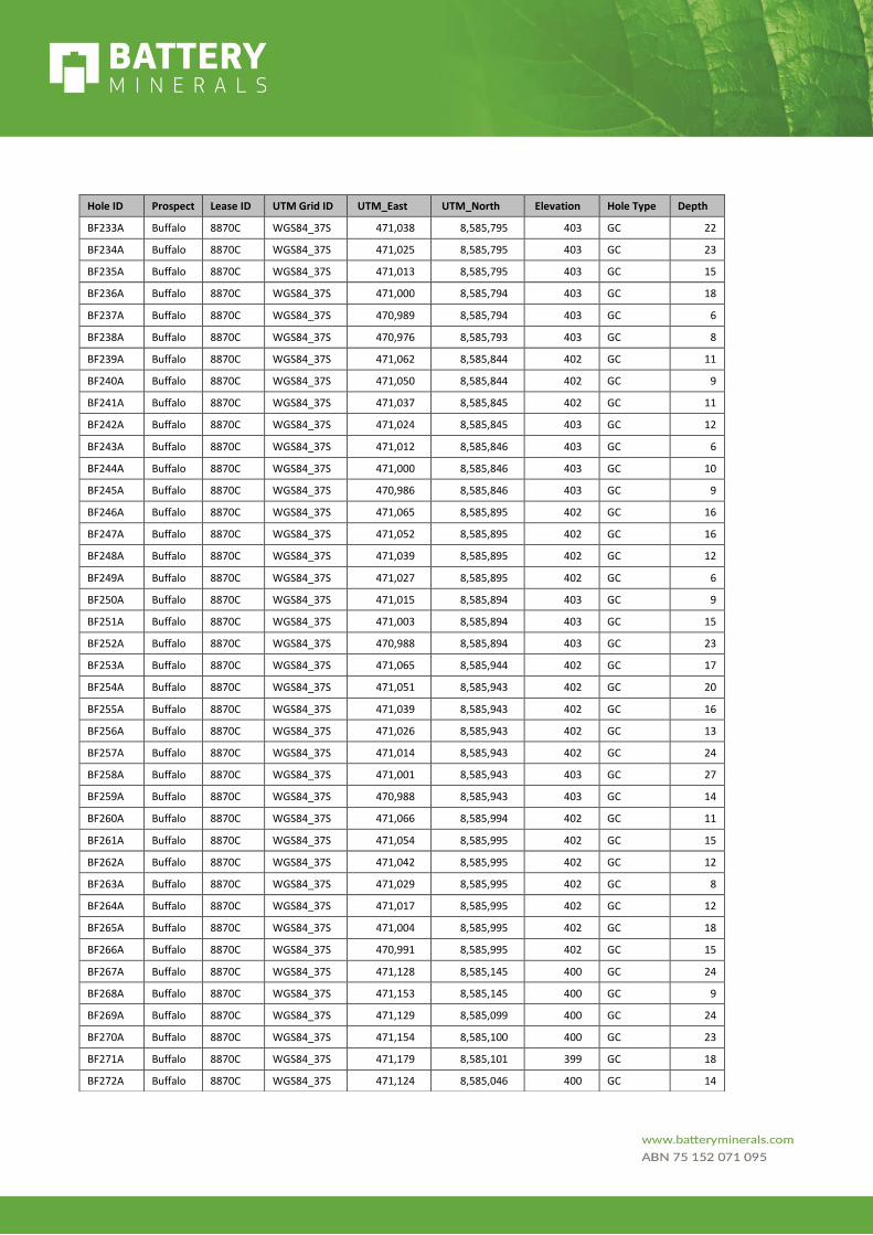
Hole ID Prospect Lease ID UTM Grid ID UTM_East UTM_North Elevation Hole Type Depth
BF233A Buffalo 8870C WGS84_37S 471,038 8,585,795 403 GC 22
BF234A Buffalo 8870C WGS84_37S 471,025 8,585,795 403 GC 23
BF235A Buffalo 8870C WGS84_37S 471,013 8,585,795 403 GC 15
BF236A Buffalo 8870C WGS84_37S 471,000 8,585,794 403 GC 18
BF237A Buffalo 8870C WGS84_37S 470,989 8,585,794 403 GC 6
BF238A Buffalo 8870C WGS84_37S 470,976 8,585,793 403 GC 8
BF239A Buffalo 8870C WGS84_37S 471,062 8,585,844 402 GC 11
BF240A Buffalo 8870C WGS84_37S 471,050 8,585,844 402 GC 9
BF241A Buffalo 8870C WGS84_37S 471,037 8,585,845 402 GC 11
BF242A Buffalo 8870C WGS84_37S 471,024 8,585,845 403 GC 12
BF243A Buffalo 8870C WGS84_37S 471,012 8,585,846 403 GC 6
BF244A Buffalo 8870C WGS84_37S 471,000 8,585,846 403 GC 10
BF245A Buffalo 8870C WGS84_37S 470,986 8,585,846 403 GC 9
BF246A Buffalo 8870C WGS84_37S 471,065 8,585,895 402 GC 16
BF247A Buffalo 8870C WGS84_37S 471,052 8,585,895 402 GC 16
BF248A Buffalo 8870C WGS84_37S 471,039 8,585,895 402 GC 12
BF249A Buffalo 8870C WGS84_37S 471,027 8,585,895 402 GC 6
BF250A Buffalo 8870C WGS84_37S 471,015 8,585,894 403 GC 9
BF251A Buffalo 8870C WGS84_37S 471,003 8,585,894 403 GC 15
BF252A Buffalo 8870C WGS84_37S 470,988 8,585,894 403 GC 23
BF253A Buffalo 8870C WGS84_37S 471,065 8,585,944 402 GC 17
BF254A Buffalo 8870C WGS84_37S 471,051 8,585,943 402 GC 20
BF255A Buffalo 8870C WGS84_37S 471,039 8,585,943 402 GC 16
BF256A Buffalo 8870C WGS84_37S 471,026 8,585,943 402 GC 13
BF257A Buffalo 8870C WGS84_37S 471,014 8,585,943 402 GC 24
BF258A Buffalo 8870C WGS84_37S 471,001 8,585,943 403 GC 27
BF259A Buffalo 8870C WGS84_37S 470,988 8,585,943 403 GC 14
BF260A Buffalo 8870C WGS84_37S 471,066 8,585,994 402 GC 11
BF261A Buffalo 8870C WGS84_37S 471,054 8,585,995 402 GC 15
BF262A Buffalo 8870C WGS84_37S 471,042 8,585,995 402 GC 12
BF263A Buffalo 8870C WGS84_37S 471,029 8,585,995 402 GC 8
BF264A Buffalo 8870C WGS84_37S 471,017 8,585,995 402 GC 12
BF265A Buffalo 8870C WGS84_37S 471,004 8,585,995 402 GC 18
BF266A Buffalo 8870C WGS84_37S 470,991 8,585,995 402 GC 15
BF267A Buffalo 8870C WGS84_37S 471,128 8,585,145 400 GC 24
BF268A Buffalo 8870C WGS84_37S 471,153 8,585,145 400 GC 9
BF269A Buffalo 8870C WGS84_37S 471,129 8,585,099 400 GC 24
BF270A Buffalo 8870C WGS84_37S 471,154 8,585,100 400 GC 23
BF271A Buffalo 8870C WGS84_37S 471,179 8,585,101 399 GC 18
BF272A Buffalo 8870C WGS84_37S 471,124 8,585,046 400 GC 14

Hole ID Prospect Lease ID UTM Grid ID UTM_East UTM_North Elevation Hole Type Depth
BF273A Buffalo 8870C WGS84_37S 471,149 8,585,047 399 GC 12
BFGT01 Buffalo 8870C WGS84_37S 470,970 8,585,497 404.5 DD 149.65
BFGT02 Buffalo 8870C WGS84_37S 471,071 8,585,503 403.5 DD 140.65
BFGT03 Buffalo 8870C WGS84_37S 471,004 8,585,296 403.6 DD 119.65
BFGT04 Buffalo 8870C WGS84_37S 471,102 8,585,305 402.2 DD 119.65
MN0004D Buffalo 8870C WGS84_37S 470,758 8,585,607 405.2 DD 190.59
MN0007D Buffalo 8870C WGS84_37S 470,980 8,585,601 404.3 DD 179.59
MN0014D Buffalo 8870C WGS84_37S 470,857 8,585,612 405.5 DD 71.59
MN0017D Buffalo 8870C WGS84_37S 471,038 8,585,599 403.9 DD 38.37
MN0018D Buffalo 8870C WGS84_37S 471,037 8,585,599 403.9 DD 141.08
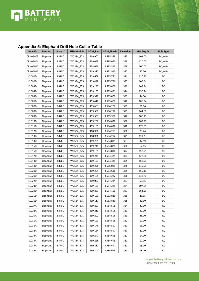
Appendix 5: Elephant Drill Hole Collar Table Hole ID Prospect Lease ID UTM Grid ID UTM_East UTM_North Elevation Max Depth Hole Type
CESWS003 Elephant 8870C WGS84_37S 469,907 8,585,358 383 102.00 RC_WBH
CESWS004 Elephant 8870C WGS84_37S 469,049 8,585,090 369 120.00 RC_WBH
CESWS010 Elephant 8870C WGS84_37S 468,043 8,583,313 369 100.00 RC_WBH
CESWS011 Elephant 8870C WGS84_37S 469,315 8,582,910 375 90.00 RC_WBH
EL001D Elephant 8870C WGS84_37S 469,658 8,585,781 391 116.80 DD
EL002D Elephant 8870C WGS84_37S 469,448 8,585,796 385 105.54 DD
EL003D Elephant 8870C WGS84_37S 469,282 8,585,000 380 102.34 DD
EL004D Elephant 8870C WGS84_37S 469,167 8,585,451 374 156.24 DD
EL005D Elephant 8870C WGS84_37S 469,328 8,585,000 383 44.54 DD
EL006D Elephant 8870C WGS84_37S 469,412 8,585,407 378 186.54 DD
EL007D Elephant 8870C WGS84_37S 469,453 8,586,208 389 71.66 DD
EL008D Elephant 8870C WGS84_37S 469,350 8,586,216 391 164.66 DD
EL009D Elephant 8870C WGS84_37S 469,501 8,585,387 376 106.13 DD
EL010D Elephant 8870C WGS84_37S 469,206 8,584,627 382 169.79 DD
EL011D Elephant 8870C WGS84_37S 469,165 8,584,636 378 176.65 DD
EL012D Elephant 8870C WGS84_37S 468,990 8,584,253 380 83.46 DD
EL013D Elephant 8870C WGS84_37S 468,936 8,584,272 379 111.23 DD
EL014D Elephant 8870C WGS84_37S 469,291 8,584,839 383 32.19 DD
EL015D Elephant 8870C WGS84_37S 469,248 8,584,828 380 62.65 DD
EL016D Elephant 8870C WGS84_37S 469,185 8,584,830 377 158.55 DD
EL017D Elephant 8870C WGS84_37S 469,241 8,584,425 387 128.60 DD
EL018D Elephant 8870C WGS84_37S 469,193 8,584,425 385 158.55 DD
EL019D Elephant 8870C WGS84_37S 469,238 8,585,025 378 140.55 DD
EL020D Elephant 8870C WGS84_37S 469,254 8,584,618 385 155.40 DD
EL021D Elephant 8870C WGS84_37S 469,185 8,584,222 386 138.70 DD
EL022D Elephant 8870C WGS84_37S 469,087 8,584,234 383 50.55 DD
EL023D Elephant 8870C WGS84_37S 469,139 8,584,225 384 107.65 DD
EL024D Elephant 8870C WGS84_37S 469,239 8,584,196 387 164.55 DD
EL025D Elephant 8870C WGS84_37S 469,169 8,583,830 386 45.55 DD
EL026D Elephant 8870C WGS84_37S 469,117 8,583,830 385 21.60 DD
EL027A Elephant 8870C WGS84_37S 469,227 8,584,595 384 37.00 RC
EL028A Elephant 8870C WGS84_37S 469,213 8,584,596 383 37.00 RC
EL029A Elephant 8870C WGS84_37S 469,202 8,584,596 383 25.00 RC
EL030A Elephant 8870C WGS84_37S 469,190 8,584,596 382 12.00 RC
EL031A Elephant 8870C WGS84_37S 469,176 8,584,597 381 15.00 RC
EL032A Elephant 8870C WGS84_37S 469,164 8,584,597 380 20.00 RC
EL033A Elephant 8870C WGS84_37S 469,240 8,584,695 382 14.00 RC
EL034A Elephant 8870C WGS84_37S 469,228 8,584,695 381 12.00 RC
EL035A Elephant 8870C WGS84_37S 469,217 8,584,697 381 15.00 RC
EL036A Elephant 8870C WGS84_37S 469,200 8,584,695 380 18.00 RC

EL037A Elephant 8870C WGS84_37S 469,190 8,584,695 380 10.00 RC
EL038A Elephant 8870C WGS84_37S 469,178 8,584,694 379 18.00 RC
EL039A Elephant 8870C WGS84_37S 469,165 8,584,694 379 14.00 RC
EL040A Elephant 8870C WGS84_37S 469,153 8,584,693 378 18.00 RC
EL041A Elephant 8870C WGS84_37S 469,229 8,584,544 385 14.00 RC
EL042A Elephant 8870C WGS84_37S 469,217 8,584,546 384 15.00 RC
EL043A Elephant 8870C WGS84_37S 469,204 8,584,546 384 24.00 RC
EL044A Elephant 8870C WGS84_37S 469,192 8,584,547 383 15.00 RC
EL045A Elephant 8870C WGS84_37S 469,180 8,584,548 382 21.00 RC
EL046A Elephant 8870C WGS84_37S 469,167 8,584,552 381 8.00 RC
EL047A Elephant 8870C WGS84_37S 469,155 8,584,553 380 18.00 RC
EL048A Elephant 8870C WGS84_37S 469,241 8,584,495 386 14.00 RC
EL049A Elephant 8870C WGS84_37S 469,228 8,584,494 385 22.00 RC
EL050A Elephant 8870C WGS84_37S 469,216 8,584,494 385 18.00 RC
EL051A Elephant 8870C WGS84_37S 469,204 8,584,494 384 15.00 RC
EL052A Elephant 8870C WGS84_37S 469,191 8,584,493 384 30.00 RC
EL053A Elephant 8870C WGS84_37S 469,179 8,584,492 384 24.00 RC
EL054A Elephant 8870C WGS84_37S 469,166 8,584,492 383 20.00 RC
EL055A Elephant 8870C WGS84_37S 469,154 8,584,491 382 23.00 RC
EL056A Elephant 8870C WGS84_37S 469,142 8,584,491 381 19.00 RC
EL057A Elephant 8870C WGS84_37S 469,279 8,584,400 388 12.00 RC
EL058A Elephant 8870C WGS84_37S 469,268 8,584,399 387 22.00 RC
EL059A Elephant 8870C WGS84_37S 469,256 8,584,399 387 21.00 RC
EL060A Elephant 8870C WGS84_37S 469,243 8,584,399 387 16.00 RC
EL061A Elephant 8870C WGS84_37S 469,231 8,584,398 386 18.00 RC
EL062A Elephant 8870C WGS84_37S 469,218 8,584,398 386 9.00 RC
EL063A Elephant 8870C WGS84_37S 469,205 8,584,397 386 18.00 RC
EL064A Elephant 8870C WGS84_37S 469,193 8,584,397 385 26.00 RC
EL065A Elephant 8870C WGS84_37S 469,181 8,584,397 385 24.00 RC
EL066A Elephant 8870C WGS84_37S 469,168 8,584,397 385 30.00 RC
EL067A Elephant 8870C WGS84_37S 469,156 8,584,396 384 16.00 RC
EL068A Elephant 8870C WGS84_37S 469,143 8,584,396 384 18.00 RC
EL069A Elephant 8870C WGS84_37S 469,130 8,584,396 384 12.00 RC
EL070A Elephant 8870C WGS84_37S 469,294 8,584,347 389 18.00 RC
EL071A Elephant 8870C WGS84_37S 469,281 8,584,347 388 36.00 RC
EL072A Elephant 8870C WGS84_37S 469,268 8,584,347 388 30.00 RC
EL073A Elephant 8870C WGS84_37S 469,256 8,584,349 388 34.00 RC
EL074A Elephant 8870C WGS84_37S 469,243 8,584,347 387 30.00 RC
EL075A Elephant 8870C WGS84_37S 469,230 8,584,346 387 11.00 RC
EL076A Elephant 8870C WGS84_37S 469,218 8,584,346 387 18.00 RC
EL077A Elephant 8870C WGS84_37S 469,205 8,584,346 386 24.00 RC
EL078A Elephant 8870C WGS84_37S 469,192 8,584,346 386 24.00 RC

EL079A Elephant 8870C WGS84_37S 469,180 8,584,343 385 24.00 RC
EL080A Elephant 8870C WGS84_37S 469,168 8,584,346 385 21.00 RC
EL081A Elephant 8870C WGS84_37S 469,155 8,584,346 385 20.00 RC
EL082A Elephant 8870C WGS84_37S 469,143 8,584,346 384 23.00 RC
EL083A Elephant 8870C WGS84_37S 469,130 8,584,343 384 6.00 RC
EL084A Elephant 8870C WGS84_37S 469,256 8,584,452 387 27.00 RC
EL085A Elephant 8870C WGS84_37S 469,244 8,584,452 386 10.00 RC
EL086A Elephant 8870C WGS84_37S 469,232 8,584,451 386 16.00 RC
EL087A Elephant 8870C WGS84_37S 469,219 8,584,450 386 24.00 RC
EL088A Elephant 8870C WGS84_37S 469,206 8,584,448 385 24.00 RC
EL089A Elephant 8870C WGS84_37S 469,194 8,584,447 384 26.00 RC
EL090A Elephant 8870C WGS84_37S 469,181 8,584,447 384 29.00 RC
EL091A Elephant 8870C WGS84_37S 469,170 8,584,446 384 26.00 RC
EL092A Elephant 8870C WGS84_37S 469,157 8,584,446 383 16.00 RC
EL093A Elephant 8870C WGS84_37S 469,145 8,584,445 382 15.00 RC
EL094A Elephant 8870C WGS84_37S 469,132 8,584,445 381 23.00 RC
EL095A Elephant 8870C WGS84_37S 469,290 8,584,293 389 17.00 RC
EL096A Elephant 8870C WGS84_37S 469,278 8,584,293 388 24.00 RC
EL097A Elephant 8870C WGS84_37S 469,266 8,584,293 388 16.00 RC
EL098A Elephant 8870C WGS84_37S 469,253 8,584,293 388 11.00 RC
EL099A Elephant 8870C WGS84_37S 469,241 8,584,294 387 23.00 RC
EL100A Elephant 8870C WGS84_37S 469,228 8,584,294 387 10.00 RC
EL101A Elephant 8870C WGS84_37S 469,215 8,584,294 387 23.00 RC
EL102A Elephant 8870C WGS84_37S 469,203 8,584,295 386 21.00 RC
EL103A Elephant 8870C WGS84_37S 469,190 8,584,295 386 17.00 RC
EL104A Elephant 8870C WGS84_37S 469,178 8,584,295 385 12.00 RC
EL105A Elephant 8870C WGS84_37S 469,166 8,584,295 385 11.00 RC
EL106A Elephant 8870C WGS84_37S 469,153 8,584,294 385 16.00 RC
EL107A Elephant 8870C WGS84_37S 469,141 8,584,294 384 18.00 RC
EL108A Elephant 8870C WGS84_37S 469,128 8,584,294 384 8.00 RC
EL109A Elephant 8870C WGS84_37S 469,291 8,584,242 389 30.00 RC
EL110A Elephant 8870C WGS84_37S 469,279 8,584,242 388 24.00 RC
EL111A Elephant 8870C WGS84_37S 469,266 8,584,242 388 22.00 RC
EL112A Elephant 8870C WGS84_37S 469,254 8,584,242 388 17.00 RC
EL113A Elephant 8870C WGS84_37S 469,241 8,584,241 387 17.00 RC
EL114A Elephant 8870C WGS84_37S 469,229 8,584,241 387 26.00 RC
EL115A Elephant 8870C WGS84_37S 469,217 8,584,241 387 26.00 RC
EL116A Elephant 8870C WGS84_37S 469,204 8,584,241 386 16.00 RC
EL117A Elephant 8870C WGS84_37S 469,192 8,584,241 386 12.00 RC
EL118A Elephant 8870C WGS84_37S 469,179 8,584,240 385 26.00 RC
EL119A Elephant 8870C WGS84_37S 469,167 8,584,240 385 30.00 RC
EL120A Elephant 8870C WGS84_37S 469,297 8,584,197 388 30.00 RC

EL121A Elephant 8870C WGS84_37S 469,269 8,584,194 388 12.00 RC
EL122A Elephant 8870C WGS84_37S 469,256 8,584,194 388 7.00 RC
EL123A Elephant 8870C WGS84_37S 469,244 8,584,193 387 21.00 RC
EL124A Elephant 8870C WGS84_37S 469,231 8,584,197 387 16.00 RC
EL125A Elephant 8870C WGS84_37S 469,219 8,584,193 387 14.00 RC
EL126A Elephant 8870C WGS84_37S 469,206 8,584,193 386 36.00 RC
EL127A Elephant 8870C WGS84_37S 469,194 8,584,193 386 17.00 RC
EL128A Elephant 8870C WGS84_37S 469,182 8,584,193 385 24.00 RC
EL129A Elephant 8870C WGS84_37S 469,156 8,584,193 385 18.00 RC
EL130A Elephant 8870C WGS84_37S 469,144 8,584,193 384 28.00 RC
EL131A Elephant 8870C WGS84_37S 469,131 8,584,193 384 30.00 RC
EL132A Elephant 8870C WGS84_37S 469,169 8,584,193 385 21.00 RC
EL133A Elephant 8870C WGS84_37S 469,154 8,584,240 385 21.00 RC
EL134A Elephant 8870C WGS84_37S 469,142 8,584,240 384 24.00 RC
EL135A Elephant 8870C WGS84_37S 469,129 8,584,240 384 12.00 RC
EL136A Elephant 8870C WGS84_37S 469,291 8,584,146 388 30.00 RC
EL137A Elephant 8870C WGS84_37S 469,278 8,584,146 388 28.00 RC
EL138A Elephant 8870C WGS84_37S 469,266 8,584,146 388 30.00 RC
EL139A Elephant 8870C WGS84_37S 469,253 8,584,146 387 28.00 RC
EL140A Elephant 8870C WGS84_37S 469,241 8,584,145 387 30.00 RC
EL141A Elephant 8870C WGS84_37S 469,228 8,584,145 387 21.00 RC
EL142A Elephant 8870C WGS84_37S 469,216 8,584,145 386 36.00 RC
EL143A Elephant 8870C WGS84_37S 469,203 8,584,144 386 36.00 RC
EL144A Elephant 8870C WGS84_37S 469,190 8,584,143 386 24.00 RC
EL145A Elephant 8870C WGS84_37S 469,165 8,584,144 385 24.00 RC
EL146A Elephant 8870C WGS84_37S 469,178 8,584,144 385 24.00 RC
EL147A Elephant 8870C WGS84_37S 469,153 8,584,143 384 24.00 RC
EL148A Elephant 8870C WGS84_37S 469,141 8,584,143 384 22.00 RC
EL149A Elephant 8870C WGS84_37S 469,128 8,584,143 384 18.00 RC
EL150A Elephant 8870C WGS84_37S 469,303 8,584,095 388 32.00 RC
EL151A Elephant 8870C WGS84_37S 469,291 8,584,095 388 30.00 RC
EL152A Elephant 8870C WGS84_37S 469,278 8,584,095 388 23.00 RC
EL153A Elephant 8870C WGS84_37S 469,266 8,584,095 387 30.00 RC
EL154A Elephant 8870C WGS84_37S 469,253 8,584,095 387 24.00 RC
EL155A Elephant 8870C WGS84_37S 469,241 8,584,095 387 23.00 RC
EL156A Elephant 8870C WGS84_37S 469,263 8,584,747 382 5.00 RC
EL157A Elephant 8870C WGS84_37S 469,250 8,584,747 382 11.00 RC
EL158A Elephant 8870C WGS84_37S 469,239 8,584,748 381 15.00 RC
EL159A Elephant 8870C WGS84_37S 469,226 8,584,748 380 21.00 RC
EL160A Elephant 8870C WGS84_37S 469,213 8,584,748 380 24.00 RC
EL161A Elephant 8870C WGS84_37S 469,201 8,584,748 379 6.00 RC
EL162A Elephant 8870C WGS84_37S 469,188 8,584,748 378 24.00 RC
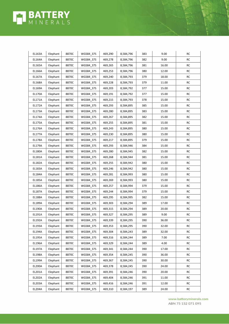
EL163A Elephant 8870C WGS84_37S 469,290 8,584,796 383 9.00 RC
EL164A Elephant 8870C WGS84_37S 469,278 8,584,796 382 9.00 RC
EL165A Elephant 8870C WGS84_37S 469,265 8,584,796 381 16.00 RC
EL166A Elephant 8870C WGS84_37S 469,253 8,584,796 380 12.00 RC
EL167A Elephant 8870C WGS84_37S 469,240 8,584,793 379 18.00 RC
EL168A Elephant 8870C WGS84_37S 469,228 8,584,793 379 11.00 RC
EL169A Elephant 8870C WGS84_37S 469,203 8,584,792 377 15.00 RC
EL170A Elephant 8870C WGS84_37S 469,191 8,584,792 377 15.00 RC
EL171A Elephant 8870C WGS84_37S 469,215 8,584,793 378 15.00 RC
EL172A Elephant 8870C WGS84_37S 469,293 8,584,895 385 15.00 RC
EL173A Elephant 8870C WGS84_37S 469,280 8,584,895 383 15.00 RC
EL174A Elephant 8870C WGS84_37S 469,267 8,584,895 382 15.00 RC
EL175A Elephant 8870C WGS84_37S 469,255 8,584,895 381 15.00 RC
EL176A Elephant 8870C WGS84_37S 469,243 8,584,895 380 15.00 RC
EL177A Elephant 8870C WGS84_37S 469,230 8,584,895 380 15.00 RC
EL178A Elephant 8870C WGS84_37S 469,217 8,584,895 379 15.00 RC
EL179A Elephant 8870C WGS84_37S 469,293 8,584,946 384 15.00 RC
EL180A Elephant 8870C WGS84_37S 469,280 8,584,945 382 15.00 RC
EL181A Elephant 8870C WGS84_37S 469,268 8,584,944 381 15.00 RC
EL182A Elephant 8870C WGS84_37S 469,255 8,584,942 380 15.00 RC
EL183A Elephant 8870C WGS84_37S 469,246 8,584,942 380 15.00 RC
EL184A Elephant 8870C WGS84_37S 469,281 8,584,993 380 15.00 RC
EL185A Elephant 8870C WGS84_37S 469,269 8,584,993 380 15.00 RC
EL186A Elephant 8870C WGS84_37S 469,257 8,584,994 379 15.00 RC
EL187A Elephant 8870C WGS84_37S 469,244 8,584,994 379 15.00 RC
EL188A Elephant 8870C WGS84_37S 469,295 8,584,995 382 15.00 RC
EL189A Elephant 8870C WGS84_37S 469,303 8,584,294 389 17.00 RC
EL190A Elephant 8870C WGS84_37S 469,315 8,584,294 389 20.00 RC
EL191A Elephant 8870C WGS84_37S 469,327 8,584,295 389 9.00 RC
EL192A Elephant 8870C WGS84_37S 469,339 8,584,295 390 36.00 RC
EL193A Elephant 8870C WGS84_37S 469,353 8,584,295 390 32.00 RC
EL194A Elephant 8870C WGS84_37S 469,304 8,584,243 389 32.00 RC
EL195A Elephant 8870C WGS84_37S 469,316 8,584,244 389 7.00 RC
EL196A Elephant 8870C WGS84_37S 469,329 8,584,244 389 4.00 RC
EL197A Elephant 8870C WGS84_37S 469,341 8,584,244 390 17.00 RC
EL198A Elephant 8870C WGS84_37S 469,354 8,584,245 390 36.00 RC
EL199A Elephant 8870C WGS84_37S 469,367 8,584,245 390 30.00 RC
EL200A Elephant 8870C WGS84_37S 469,378 8,584,245 390 24.00 RC
EL201A Elephant 8870C WGS84_37S 469,391 8,584,246 390 20.00 RC
EL202A Elephant 8870C WGS84_37S 469,404 8,584,246 391 11.00 RC
EL203A Elephant 8870C WGS84_37S 469,416 8,584,246 391 12.00 RC
EL204A Elephant 8870C WGS84_37S 469,310 8,584,197 389 24.00 RC
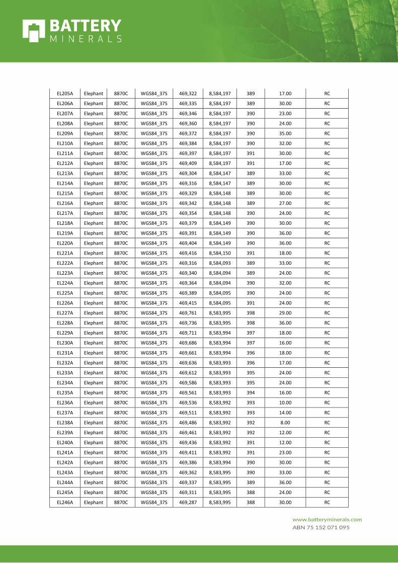
EL205A Elephant 8870C WGS84_37S 469,322 8,584,197 389 17.00 RC
EL206A Elephant 8870C WGS84_37S 469,335 8,584,197 389 30.00 RC
EL207A Elephant 8870C WGS84_37S 469,346 8,584,197 390 23.00 RC
EL208A Elephant 8870C WGS84_37S 469,360 8,584,197 390 24.00 RC
EL209A Elephant 8870C WGS84_37S 469,372 8,584,197 390 35.00 RC
EL210A Elephant 8870C WGS84_37S 469,384 8,584,197 390 32.00 RC
EL211A Elephant 8870C WGS84_37S 469,397 8,584,197 391 30.00 RC
EL212A Elephant 8870C WGS84_37S 469,409 8,584,197 391 17.00 RC
EL213A Elephant 8870C WGS84_37S 469,304 8,584,147 389 33.00 RC
EL214A Elephant 8870C WGS84_37S 469,316 8,584,147 389 30.00 RC
EL215A Elephant 8870C WGS84_37S 469,329 8,584,148 389 30.00 RC
EL216A Elephant 8870C WGS84_37S 469,342 8,584,148 389 27.00 RC
EL217A Elephant 8870C WGS84_37S 469,354 8,584,148 390 24.00 RC
EL218A Elephant 8870C WGS84_37S 469,379 8,584,149 390 30.00 RC
EL219A Elephant 8870C WGS84_37S 469,391 8,584,149 390 36.00 RC
EL220A Elephant 8870C WGS84_37S 469,404 8,584,149 390 36.00 RC
EL221A Elephant 8870C WGS84_37S 469,416 8,584,150 391 18.00 RC
EL222A Elephant 8870C WGS84_37S 469,316 8,584,093 389 33.00 RC
EL223A Elephant 8870C WGS84_37S 469,340 8,584,094 389 24.00 RC
EL224A Elephant 8870C WGS84_37S 469,364 8,584,094 390 32.00 RC
EL225A Elephant 8870C WGS84_37S 469,389 8,584,095 390 24.00 RC
EL226A Elephant 8870C WGS84_37S 469,415 8,584,095 391 24.00 RC
EL227A Elephant 8870C WGS84_37S 469,761 8,583,995 398 29.00 RC
EL228A Elephant 8870C WGS84_37S 469,736 8,583,995 398 36.00 RC
EL229A Elephant 8870C WGS84_37S 469,711 8,583,994 397 18.00 RC
EL230A Elephant 8870C WGS84_37S 469,686 8,583,994 397 16.00 RC
EL231A Elephant 8870C WGS84_37S 469,661 8,583,994 396 18.00 RC
EL232A Elephant 8870C WGS84_37S 469,636 8,583,993 396 17.00 RC
EL233A Elephant 8870C WGS84_37S 469,612 8,583,993 395 24.00 RC
EL234A Elephant 8870C WGS84_37S 469,586 8,583,993 395 24.00 RC
EL235A Elephant 8870C WGS84_37S 469,561 8,583,993 394 16.00 RC
EL236A Elephant 8870C WGS84_37S 469,536 8,583,992 393 10.00 RC
EL237A Elephant 8870C WGS84_37S 469,511 8,583,992 393 14.00 RC
EL238A Elephant 8870C WGS84_37S 469,486 8,583,992 392 8.00 RC
EL239A Elephant 8870C WGS84_37S 469,461 8,583,992 392 12.00 RC
EL240A Elephant 8870C WGS84_37S 469,436 8,583,992 391 12.00 RC
EL241A Elephant 8870C WGS84_37S 469,411 8,583,992 391 23.00 RC
EL242A Elephant 8870C WGS84_37S 469,386 8,583,994 390 30.00 RC
EL243A Elephant 8870C WGS84_37S 469,362 8,583,995 390 33.00 RC
EL244A Elephant 8870C WGS84_37S 469,337 8,583,995 389 36.00 RC
EL245A Elephant 8870C WGS84_37S 469,311 8,583,995 388 24.00 RC
EL246A Elephant 8870C WGS84_37S 469,287 8,583,995 388 30.00 RC
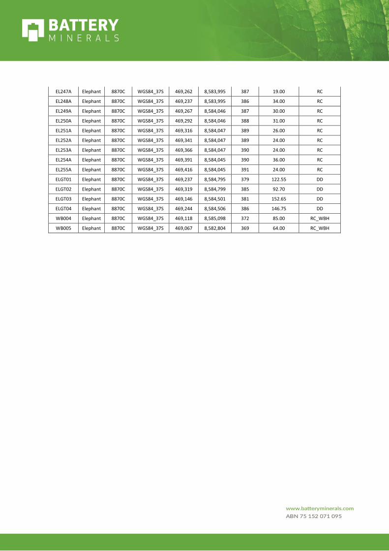
EL247A Elephant 8870C WGS84_37S 469,262 8,583,995 387 19.00 RC
EL248A Elephant 8870C WGS84_37S 469,237 8,583,995 386 34.00 RC
EL249A Elephant 8870C WGS84_37S 469,267 8,584,046 387 30.00 RC
EL250A Elephant 8870C WGS84_37S 469,292 8,584,046 388 31.00 RC
EL251A Elephant 8870C WGS84_37S 469,316 8,584,047 389 26.00 RC
EL252A Elephant 8870C WGS84_37S 469,341 8,584,047 389 24.00 RC
EL253A Elephant 8870C WGS84_37S 469,366 8,584,047 390 24.00 RC
EL254A Elephant 8870C WGS84_37S 469,391 8,584,045 390 36.00 RC
EL255A Elephant 8870C WGS84_37S 469,416 8,584,045 391 24.00 RC
ELGT01 Elephant 8870C WGS84_37S 469,237 8,584,795 379 122.55 DD
ELGT02 Elephant 8870C WGS84_37S 469,319 8,584,799 385 92.70 DD
ELGT03 Elephant 8870C WGS84_37S 469,146 8,584,501 381 152.65 DD
ELGT04 Elephant 8870C WGS84_37S 469,244 8,584,506 386 146.75 DD
WB004 Elephant 8870C WGS84_37S 469,118 8,585,098 372 85.00 RC_WBH
WB005 Elephant 8870C WGS84_37S 469,067 8,582,804 369 64.00 RC_WBH