Embed Size (px)
Citation preview

AD-AI05 729 EROMAN ANTHONY ASSOCIATES ROCHESTER NY FIG 13/13NATIONAL DAM SAFETY PRORAM. BURT DAM (INVENTORY N7UMBR N.Y. 74--ETC(U)AUG 81 R J FARRELL DACWSI-81-C-0017
UNCLASSIFIED NL
2 fllfflllffllffoIInIIIINhunMMmmhhhhmhhMlMIhhEMEhIEIBOElmhIhhhhhhhmImlIMmIImIIIIl/M/mm/EhhhlIIIIIIIIIIIIII

I LAKE ONTARIO BASI
BURT DAM
[ NIAGARA COUNTY, NEW YORKIi INVENTORY Ne. N.Y, 745
PHASE I IM~PffION RJP1 R TNATIONAL DAM SAFETY PROGRAM
[
[ 2 MEW YOM DISTRICT, COWPS oF NIN S
DTICU i . ELECTE
j- "".. -.,1 OCT 19 1981 j I!AUGST 198*1 cT'"a
DISTRIBUTION STATEMENT A .
Appzoved fox publia xeleo.aNe
I Distribution Unlimited

______REPOU TDOCMETATION P,\CE PE~AD IN STRUCT CON4S_______ ____1-_1_os FORM COM PLS-Mft- F 0R4
1. CEPORT rIU:aH 2. GOVT AcceSSsioN No. 3 c. TcArA.u) =
4. TITLE (am4 S..beUlI) .5. "TYP! OP RtPOT PEfnoO COVE[EO
Phase I Inspection'Report Phase I IrLspection RoportBurt Dam National Dam Safety PrograaLake Ontario Basin, Niagara County, NY S. PRFORONGORO. MFUORT I'OU48iF
Inventory No. 7457. AUTNOp(..) * ''A.OiGAN I3'4)
ROBERT J. FARRELL DACW51-.81-C-0017. IRORMING ORGANIlZATION NAMZ ANDO ,,MORES,1. PROGRAN& LE'LE P EoTR. TASK
S. P~tMIGO~AMIATOM ~e~AHOAO~tES *AREA, dcORK UMT HU263XRS
* Erdman ,Anthony, Associates;I 942 An res.Sriet.P~0o 9589"-oches er, sNew OrP 1 6 0 P9"
11. COnLTROAI.NG OFPIC MANZ AND AODRESS R.PORT DV
Department of the'Army .27 August 1981
26 Federal Plaza New York.District, Cofe L. NuMB'_oa s:
New York, New York 1028714. MONITORING AGENCY NAME 6 ADCRESS(MiIteront from Can'roMItnOthn ) IS- SECU;I-e M.%-%Dpartment of the Army26 Federal Plaza New York District, CofE UNCL-ASSIFIEDNew York, ,NY 10237 5.. DECLASSI;ICATIONIDOO.GRAOI.
1. DISTRIBUTION STAT-14N T (of 0I1. i CHOoE1
Approved for public ralease; Distribution unlir2ited-
17. VI3TRIaUTIO. STA'MM,ENT (of the aZ,311,,l ent.,ed In Bo*.c 20, It flf!.r,?Tir.., RpeJrq
* . -.. -
*t I. SUPPLE.MINTARY MOTZ.-
.................. .............. " ................................. ..............
13 Z WMS(Cnb40o evrod& It necssar and8 Identify by block ntaftart ajn*)Damn SafetyNational Dam Safety Program . .Burt Dam "'-
Visual Inspection. Niagara Countyydrlogy, St rctural Stability Lake Ontario'.Basn .-
varp Ar r_-vC&=-fvf It rm - .,o,4 id-Wfl by block mLob..)
This repoct p- ;-idea infor'.ation and analysis on tfa p-., conditlax oE thedam as of the r.2iort date. Information and analysi3arZ O4 t visual.inspection of the dam by the perfo:.t' . organizati~a.
Examination of available documents and a visual inspection of the dam did notreveal conditions which constitute an immediate hazard to human life and property.However, the dam has some deficiencies which require further investigation andremedial action.
DD......"" - "-- .... M t. "-.".. o - --.. .is
L .. .. . . ... . .... .. .- l i - . . - ' 1I -+ i, ,

- Sr-.CURtTY CLAI.SIHCATIC19 or THIS IPAGt(Wn bDtq l~nfod) _______________________
not The hydrologic/hydraulic analysis performed indicates that the spillway does
not have sufficient capacity to discharge the peak outflow from one-half the ProbableMaximum Flood (PMF). However, spillway discharges occurring during large stormevents will cause water surface elevations in the downstream hazard area to riseto flood levels. A dam failure resulting from overtopping would not significantly increasethe hazard to loss of life from that which would exist just prior to an overtoppingfailure. Therefore, the spillway is assessed as inadequate.
Since the structural stability analysis performed by the dam's designer couldnot be located, an analysis was performed as part of this Phase I Investigation. Itindicated that the sliding and overturning factors of safety, for normal operatingconditions, are less than the recommended minimum values. In addition, the damis located in Seismic Zone 3, and there is no record of a suitable seismic analysisbeing performed. Therefore, an additional investigation by a qualified registeredprofessional engineer to evaluate the normal and seismic stability of the dam isrecommended.
The investigation should be completed within 12 months of notification tothe owner, and remedial actions resulting from the investigation completed in thesubsequent 12 months.
The following remedial measures should be performed within I year of
notification to owner:
- Replace the missing floor grating on the bridge across the spillway.
- Paint the bridge across the spillway.
- Install hand rails the full length of the dam crest.
- Repair the gate hoist controlling the reservoir drain gate.
- Install fencing at the east abutment and post warning signs at bothabutments to discourage treaspassers.Clean debris and vegetation from areas atop the downstream face ofdam and from both abutments.
Implement a program of diligent and periodic maintenance includingbut not limited to: operation and lubrication of the reservoir drain, patchingspalled and eroded concrete areas, and clearing debris and trash fromtrash racks, and from upstream slopes.
Develop a formal written downstream warning system to alert the appropriateofficials and residents in the event of an emergency.
- Develop and maintain a program of biannual technical inspections.• o. -. o
SECUITY CLA-.IICAf|OH Of THIUi PAfMlI .' 1', .l Ilt*id)
: _ " _ I X I WI

*1 'I
I I;zAccession For
! TiC TAB I LAKE ONTARIO BASINUnannounced
Bv ________; .istribut ion/ .
AvAi'lTbility CodesBURTA..-I1 and/or .URT DAM
'AL't Special
SNIAGARA COUNTY, NEW YORKI INVENTORY No. N.Y. 745
PHASE I INSPECTIONRER[ 6 NATIONAL DAM SAFETY PROGRAM.
Burt Dam (Inventory Number . 745)--Lake Ontario Basin Niagara County,[ New York. Phase ? Inspection Report
0 DTIC
.DACW5.-81-C-. OCT 19 1981
IAus8i D
NE YRK DISTRICT, CORPS OF ENGINEERS
1 AUGUST 1981J APPROVED FOR PUIBLIC RELEASE;
DISTRIBUTION UNLIMITED
* 10 10 19

PREFACE
This report is prepared under guidance contained in the Recommended GuidelinesI for Safety Inspection of Dams for Phase I Investigations. Copies of these guidelines
may be obtained from the Office of Chief of Engineers, Washington, D.C. 20314.The purpose of a Phase I Investigation is to identify expeditiously those damswhich may pose hazards to human life or property. The assessment of the generalcondition of the dam is based upon available data and visual inspections. Detailedinvestigation and analyses involving topographic mapping, subsurface investigations,testing, and detailed computational evaluations are beyond the scope of a PhaseI Investigation; however, the investigation is intended to identify any need forsuch studies.
In reviewing this report, it should be realized that the reported condition ofthe dam is based on observations of field conditions at the time of inspection
I along with data available to the inspection team. In cases where the reservoirwas lowered or drained prior to inspection, such action, while improving theIstability and safety of the dam, removes the normal load on the structure andmay obscure certain conditions which might otherwise be detectable if inspectedunder the normal operating environment of the structure.
It is important to note that the condition of a dam depends on numerous andconstantly changing internal and external conditions, and is evolutionary innature. It would be incorrect to assume that the present condition of the damwill continue to represent the condition of the dam at some point in the future.Only through frequent inspections can unsafe conditions be detected and onlythrough continued care and maintenance can these conditions be preventedor corrected.
Phase I Inspections are not intended to provide detailed hydrologic and hydraulicanalyses. In accordance with the established Guidelines, the Spillway Test Floodis based on the estimated "Probable Maximum Flood" for the region (greatestreasonably possible storm runoff), or fractions thereof. Because of the magnitudeand rarity of such a storm event a finding that a spillway will not pass the TestFlood should not be interpreted as necessarily posing a highly inadequate condition.The Test Flood provides a measure of relative spillway capacity and serves
7 as an aid in determining the need for more detailed hydrologic and hydraulicstudies, considering the size of the dam, its general condition and the downstream
damage potential.

I' TABLE OF CONTENTS
PAGE
OVERVIEW PHOTO
LOCATION MAP
SECTION I PROJECT INFORMATION
1.1 General1-1.2 Description1-1.3 Pertinent Data 1-3
SECTION 2 ENGINEERING DATA
2.1 Geology 2-12.2 Subsurface Investigation 2-12.3 Design Records 2-12.4 Construction Records 2-12.5 Operation Records 2-12.6 Evaluation of Data 2-1
SECTION 3 VISUAL INSPECTION
3.1 Findings 3-13.2 Evaluation of Observations 3-1
SECTION 4 OPERATION AND MAINTENANCE PROCEDURES
4.1 Procedures 4-14.2 Maintenance of Dam4-4.3 Warning System in Effect 4-14.4 Evaluation 4-1
SECTION 5 HYDRAULIC/HYDROLOGIC
5.1 Drainage Area Characteristics .5-15.2 Design Data 5-15.3 Analysis Criteria5-5.4 Reservoir Capacity 5-15.5 Experience Data 5-25.6 Overtopping Potential 5-25.7 Analysis of Downstream Impacts 5-2
115.8 Evaluation 5-2

[ TABLE OF CONTENTS - con't.
1.[ PAGE
SECTION 6 STRUCTURAL STABILITY
6.1 Visual Operations 6-16.2 Design and Construction Data 6-16.3 Operating Records 6-1. 6.4 Post Construction Changes 6-16.5 Seismic Stability 6-16.6 Structural Stability Analysis 6-1
SECTION 7 ASSESSMENT, RECOMMENDATIONSAND REMEDIAL MEASURES
1 7.1 Assessment 7-17.2 Recommended Measures 7-1
I APPENDICES
APPENDIX A INSPECTION CHECKLIST A-I
APPENDIX B ENGINEERING DATA B-I
APPENDIX C PHOTOGRAPHS C-I
I APPENDIX D HYDRAULIC/HYDROLOGIC COMPUTATIONS D-I
APPENDIX E REFERENCES E-I
APPENDIX F STABILITY ANALYSIS F-I
APPENDIX G PREVIOUS INSPECTIONREPORTS/AVAILABLE DOCUMENTS G- I
Ii
iII
I -"

I PHASE I INSPECTION REPORT
NATIONAL DAM SAFETY PROGRAM
Name of Dam: Burt Dam
State Located: New York
County Located: Niagara
Stream: Eighteenmile Creek
0Basin: Lake Ontario
Date of Inspection: May 19, 1981
ASSESSMENT
Examination of available documents and a visual inspection of the dam did notreveal conditions which constitute an immediate hazard to human life and property.However, the dam has some deficiencies which require further investigation andremedial action.
The hydrologic/hydraulic analysis performed indicates that the spillway doesnot have sufficient capacity to discharge the peak outflow from one-half the ProbableMaximum Flood (PM F). However, spillway discharges occurring during large storm
I events will cause water surface elevations in the downstream hazard area to riseto flood levels. A dam failure resulting from overtopping would not significantly increasethe hazard to loss of life from that which would exist just prior to an overtopping
failure. Therefore, the spillway is assessed as inadequate.
Since the structural stability analysis performed by the dam's designer couldnot be located, an analysis was performed as part of this Phase I Investigation. It
indicated that the sliding and overturning factors of safety, for normal operatingconditions, are less than the recommended minimum values. In addition, the damis located in Seismic Zone 3, and there is no record of a suitable seismic analysisbeing performed. Therefore, an additional investigation by a qualified registeredprofessional engineer to evaluate the normal and seismic stability of the dam is[ recommended.
The investigation should be completed within 12 months of notification tothe owner, and remedial actions resulting from the investigation completed in theI! subsequent 12 months.
.1

The following remedial measures should be performed within 1 year of[ notification to owner:
- Replace the missing floor grating on the bridge across the spillway.
L Paint the bridge across the spillway.- Install hand rails the full length of the dam crest.I- Repair the gate hoist controlling the reservoir drain gate.- Install fencing at the east abutment and post warning signs at both
abutments to discourage treaspassers.- Clean debris and vegetation from areas atop the downstream face of
dam and from both abutments.
- Implement a program of diligent and periodic maintenance includingbut not limited to: operation and lubrication of the reservoir drain, patchingspalled and eroded concrete areas, and clearing debris and trash fromtrash racks, and from upstream slopes.
- Develop a formal written downstream warning system to alert the appropriate
officials and residents in the event of an emergency.
- Develop and maintain a program of biannual technical inspections.
Robert J. Farrell, P.E.New York No. 55983
Approved by:
Date: K7
IfU

~Ti~ Burt Dam
IIIIIIIII
*
II
OVERVIEW
I [I
'I 4
UKU

I- --------
I ~ ~ke '-
It KScle V.00'

U I
PHASE I INSPECTION REPORTNATIONAL DAM SAFETY PROGRAM
BURT DAMI.D. NO. NY 745
D.E.C. NO. 15C-272LAKE ONTARIO BASIN '
NIAGARA COUNTY, NEW YORK
SECTION I - PROJECT INFORMATION
1.1 GENERAL
a. Authority
The Phase I inspection reported herein was authorized bythe Department of the Army, New York District, Corps of Engineers,to fulfill the requirements of the National Dam Inspection Act, PublicLaw 92-367, dated 8 August 1972.
b. Purpose of Inspection
This inspection was conduted to evaluate the existing conditionsof the dam, to identify deficiencies and hazardous conditions, to determineif these deficiencies constitute hazards to life and property, and to recommendremedial measures where required.
1.2 DESCRIPTION OF THE PROJECT
a. Description of Dam and Appurtenances
Burt Dam is an unreinforced concrete gravity dam with an ogeespillway located near the west abutment. It is approximately 328 ft. longand has a maximum height of 54.5 ft. The crest width of the dam is 5 ft.The upstream face of the dam is vertical. The downstream face is verticalfor the top 7.5 ft. below which the face slopes at approximately I ft.vertical to .77 ft. horizontal.
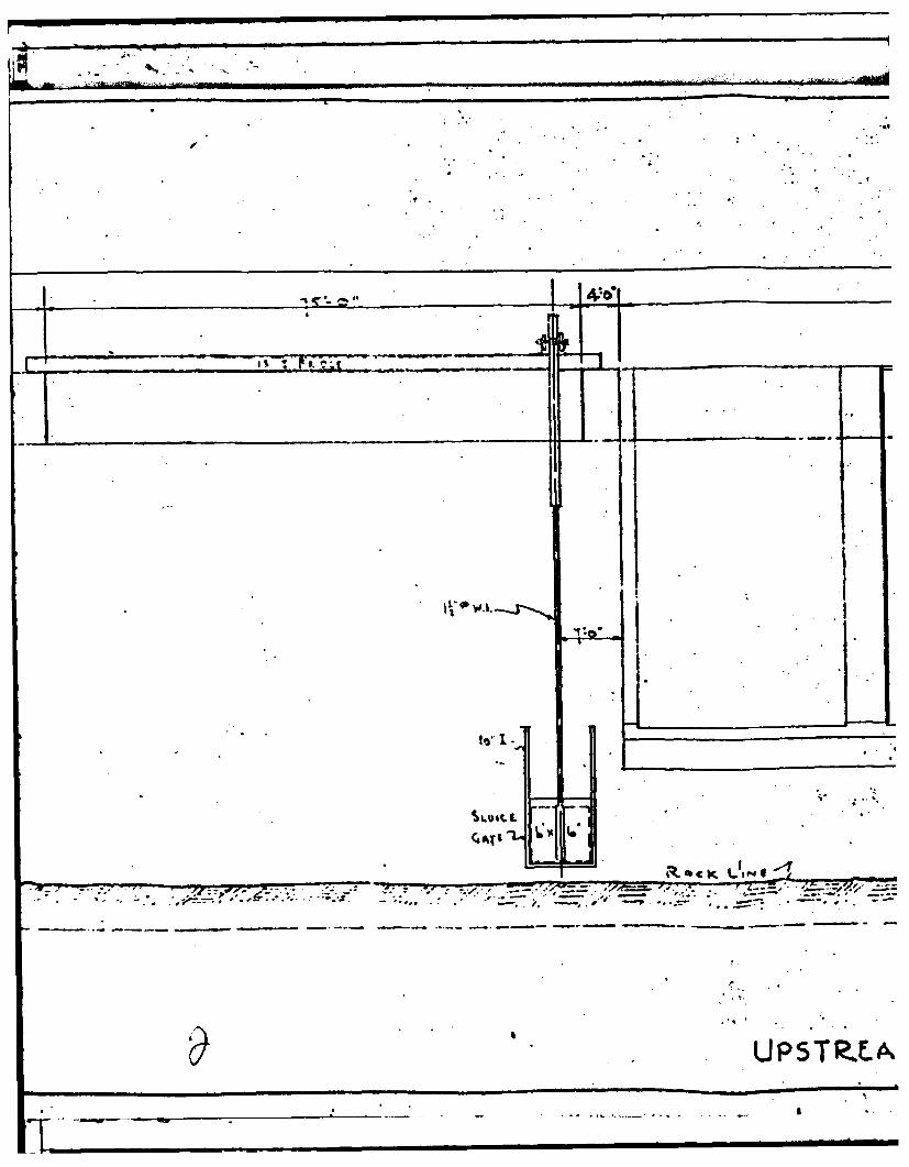
The principal ogee spillway is 75 ft. wide and 7.5 ft. deep. The reservoirdrain consists of a 6 ft. conduit running through the east end of the spillwaysection. It is operated by a vertical lift sluice gate with a gate hoist positionedon the walkway above the spillway.
The dam contains three penstocks. According to the design calculationstwo measure 9 f t. by 14 f t. while the third is I If t, by 18 f t. The penstocks,located near the center of the dam, at one time carried flow to the turbinesin the powerhouse on the downstream face of the dam. The flow into thepenstocks was controlled by two vertical lift sluice gates per penstock.
b. Location
The dam is located on Eighteenmile Creek approximately 0.2 milessouth of Burt, New York. The dam is approximately 1.5 miles south ofthe intersection of N.Y.S. Route 18 and 78.
C. Size Classification
The dam is 54.5 ft. high and the reservoir has a storage cpityof 2447 acre-ft. The dam is classified as "INTER MEDIA TE11 insz40to 100 ft. in height).
d. Hazard Classification
The hazard classification for this dam is HIGH because of the potentialfor loss of life and property 2.0 miles downstream in the event of damfailure.
e. Ownership
Burt Dam is owned by the Olcott Harbor Board of Trade, a localassociation of businessmen. No address or telephone is listed for thisorganization. An application for converting the dam to power generationis pending with the Federal Energy Regulatory Commission by:
J. W. CompanyJeffery Moon, President55 Union PlaceManchester, Connecticut 06040Tele: (207) 775-5401
f. Purpose of Dam
Burt Dam was originally constructed for hydroelectric powerj generation. It presently serves no useful purpose.
g. Design and Construction Historyj The dam was designed and ccnstructed by McCarthy Brothers
and Ford of Buffalo, New York in 1924. The original owner was Lockportand Newfane Power and Water Supply Co.; it was later sold to NiagaraMohawk Power Co. "As-built" dam drawings were obtained from the NewYork State Department of Environmental Conservation, Albany, NewYork.
h. Normal Operating Procedure
No regular procedure of operating the sluice gates at the[ dam presently exists. Normal flows pass over the ogee spillway.
1 1-2

Ii!
1.3 PERTINENT DATAa. Drainage Area 77.4 sq. milesb. Discharge at Damsite
Maximum known flood at Damsite UnknownRecent maximum discharge (from high water mark) 1867 cfsPrincipal Spillway
Maximum Pool 6116 cfsTotal Spillway Capacity at Maximum
Pool Elevation 6116 cfs
c. Elevation (U.S.G.S. Datum)
Top of Dam 304.5 ft.Maximum Pool 304.5 ft.Normal Pool 297.0 ft.Principal Spillway Crest 297.0 ft.
d. Reservoir
Length of Normal Pool 1050 ft.Length of Maximum Pool 1300 ft.
e. StorageNormal Pool 1488 acre-ft.Maximum Pool 2447 acre-ft.
f. Reservoir SurfaceNormal Pool 95 acresMaximum Pool 149 acres
g. Dam
Type Concrete GravityLength 328! ft.Maximum Height 54.5f ft.Top Width 5 ft.Side Slopes (V:H)
Upstream VerticalDownstream Vertical to
IV:0.77H'I ___________
h. Reservoir DrainType ConduitIi Dimensions 6 ft. x 6 ft.Closure Vertical lift
sluice gateInvert Elevation 252 ft.
i. Principal SpillwayType Concrete Ogee
I Base Width 75 ft.Height 7.5 ft.Side Slopes VerticalLocation Near west abutment
1-3/i

SECTION 2 - ENGINEERING DATA
1 2.1 GEOLOGY
* The stratigraphy in northern Niagara County consists of relatively undeformed* flat-lying sedimentary rocks of upper Ordovician age (450-425 million years ago).* The bedrock formation is red bedded, massive shales with some interbedded silt-
stones and silty dolomites of the Queenston Shale Formation. The shale rock isgenerally moderately soft, and tends to break down rapidly upon exposure. TheI siltstones and silty dolomites are generally moderately hard and tend to resist
5. weathering. The rock forms a homocline which dips southward to southwestwardat approximately 40 feet per mile. Only minor folding and faulting are found in
I the region with no major or active faults known to exist in the area.
The Village of Olcott and the Burt Dam are in a region classified as Zone3 seismicity, as shown on Figure No. I of the Recommended Guidelines for SafetyII Inspection of Dams.
Glaciations of the area was extensive. During the glacial period (PleistoceneEopch), spanning about 1.5 million years, the area was over-ridden many timesF by a thick continental ice sheet moving southward over the region, from Quebecand Ontario, eroding the rock and changing drainage patterns. Soil deposits leftby the glacier include lake silt, sand and clayey silts deposited as off-shore deposits
of primitive lakes of the Lake Iroquois stage in the Ontario basin.
2.2 SUBSURFACE INVESTIGATION
No subsurface investigations could be located for the dam.
J 2.3 DESIGN RECORDS
The records available for the project consist of 4 contract drawings whichshow plans, sections and details of the dam and powerhouse, the original "applicationI for Construction of a Dam", and several sheets of correspondence, some of whichdiscuss the selected design discharge.
2.4 CONSTRUCTION RECORDS
The only construction records available consist of correspondenceI between the dam's designer and various public agencies.2.5 OPERATION RECORD
I - An effort to locate the operation record was unsuccessful.
2.6 EVALUATION OF DATA
Ii The information presented was obtained primarily from NYSDEC files andappears adequate and reliable for Phase I inspection and evaluation.
[i 2-1

SECTION 3 - VISUAL INSPECTION
3.1 FINDINGS
a. GeneralA visual inspection of Burt Dam was made on May 19, 1981. The weather
was sunny, and the temperature was in the mid-seventies. The reservoirlevel at the time of the inspection was at elevation 297.5 MSL, 6 in. abovethe spillway crest.
b. Foundation
* Foundation rock is generally competent and lightly weatheredfrom the left abutment downstream. There is a horizontal clay seam (1/4in. to 1/2 in. thick) approximately 6 ft. above the tailwater surface. Water
'4 exits this seam as a minor weep of approximately 2 GPM for its entire length.Scree covers the slope at the right abutment. Downstream of the dam (150ft. to 200 ft.) is an outcrop of red, thin to medium bedded shale, which ismoderately weathered. Slaking shale has been deposited downslope.
C. _ Da
The dam is generally in good condition. However, several deficienciesand areas of deterioration were noted. These include:
1. Significant areas of eroded and spalled concrete were observedalong the entire crest of the dam, as well as along both spillway sidewalls.In addition, cracks, significant spalls and effervescent stains were observedon the downstream face of the dam; although it was completely dryat the time of the inspection.
2. The gate hoist controlling the reservoir drain sluice gate is inoperative.The electric motor has been removed, and the electrical wiring hasbeen disconnected and abandonded.
3. The wood stairs at the east abutment are seriously deteriorated.
4. Water seepage was observed along the west side of the west spillway
sidewall.5. Trees and vegetation were observed at both abutmentsand atop the downstream face of the dam.
3.2 EVALUATION OF OBSERVATIONS
Visual observations made during the course of the inspection did not indicateany serious problems which would adversely affect the adequacy of the dam. Thefollowing is a summary of the problem areas encountered, in order of importance,V with the appropriate recommended action:
3-1

1. The missing floor grating on the bridge across the spillway
I should be replaced. The entire bridge should be painted.
2. Handrails should be installed the full length of the dam crest.
4 3. The stairs at the east abutment should be repaired orreplaced.4. The gate hoist controlling the reservoir drain sluice gate should be
L made operational. The gate should be exercised and lubricated annually.
5. The reservoir should be lowered below the spillway crest so that thespillway and downstream toe of the dam can be inspected.
6. Fencing should be installed at the east abutment and warning signsposted at both abutments to discourage trespassers.
7. The concrete cracks and spalls should be monitored.
8. Some debris has collected near the crest of the principal spillway. This
debris should be removed on an annual basis.
3-2-

4.1 SECTION 4 - OPERATION AND MAINTENANCE PROCEDURES
41PROCEDURES
* I No written operation and maintenance procedures exist for the project.The normal operation of the project consists of allowing water to flow over thespillway section of the dam. It appears that the reservoir drain has not been usedin many years.
4.2 MAINTENANCE OF DAMThe dam's owner, the Olcott Harbor Board of Trade, practices a policy of
deferred maintenance.
4.3 WARNING SYSTEM IN EFFECT
No warning system is in ef fect or in preparation.
4.4 EVALUATION
The dam and appurtenances have not been maintained in satisfactorycondition as noted in "Section 3: Visual Inspection".
4-

d ..0 • , .&
SECTION 5- HYDRAULIC/HYDROLOGIC
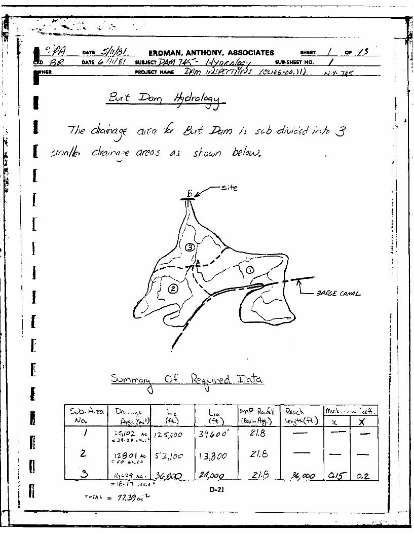
5.1 DRAINAGE AREA CHARACTERISTICS
Burt Dam is located on Eighteenmile Creek in the Lake Ontario basin, and hasa drainage area of 77.4 square miles. The dam is situated approximately 1200 ft. southof Burt, New York in the Town of Newfane. The topography of the watershed is gentlynorthward sloping farmlands, with orchards and woodland.
5.2 DESIGN DATA
Burt Dam was constructed for the purpose of hydroelectric power generation,although power is not currently being generated. According to the application forconstruction of the dam, dated April 24, 1924, the design flow for the dam was 5,940cfs (144 cfs/acre). This figure was computed by assuming a peak flow of 64 cfs/sq. mi.over an 85 square mile drainage basin plus 500 cfs overflow from the New York StateBarge Canal. The combined discharges from the spillway, penstocks, and sluice gateof 5953 cfs produces a design high water of 302.0 ft. (MSL). The ogee spillway controlcross section is 75 ft. wide with a crest elevation of 297.0 ft. (MSL). The dam crestelevation is 304.5 ft. (MSL).
5.3 ANALYSIS CRITERIA
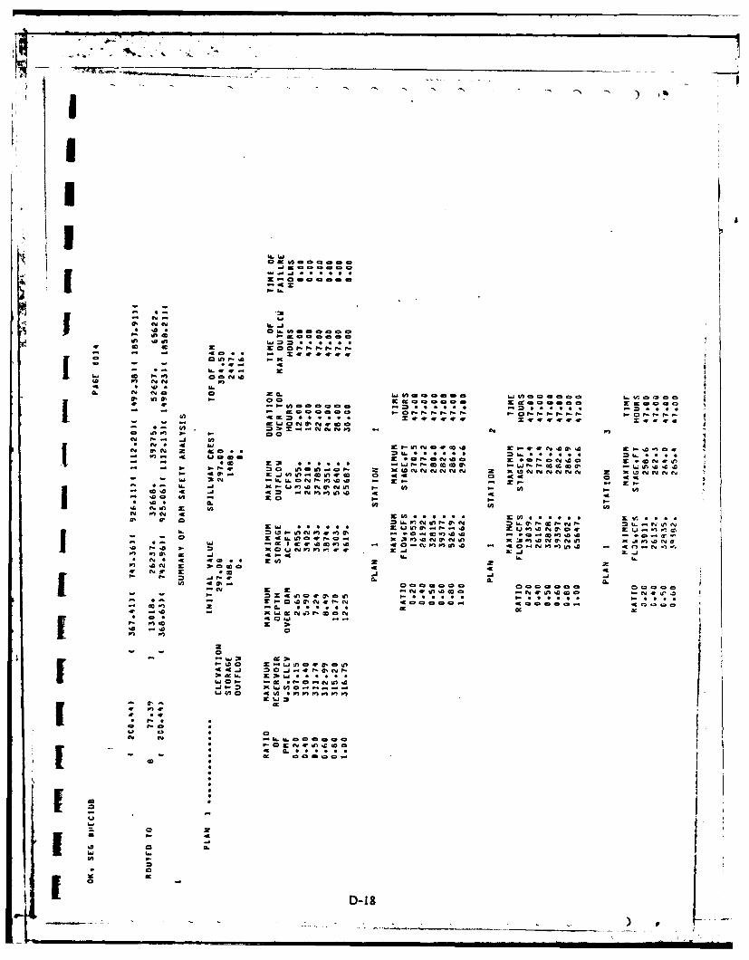
The analysis of the spillway capacity of the dam and the storage of the reservoirwas performed using the Corps of Engineers HEC-1 Dam Safety Version computermodel. The unit hydrograph was defined by the Snyder Synthetic Unit Hydrographmethod. The drainage area for Burt Dam was divided into three smaller drainageareas: Eighteenmile Creek, East Branch Eighteenmile Creek, and the West BranchEighteenmile Creek; and routed downstream by means of the Muskingam routing procedure.The three penstocks and the reservoir drain gate are inoperable and were excludedas factors in the hydraulic analysis as were the tailwater effects of Lake Ontario.The Probable Maximum Precipitation (PMP) was 21.8 in. (24 hours 200 sq. miles) fromHydrometerological Report #33 in accordance with the Recommended Guidelinesof the Corps of Engineers. The dam is 54.5 ft. high and impounds approximately 2447acre-ft. at the top of the dam. The dam is classified as a HIGH hazard and INTERMEDIATEin size, according to the Recommended Guidelines of the Corps of Engineers. Thespillway design flood is the Probable Maximum Flood (PMF). The floods selected foranalysis were 20, 40, 50, 60, 80 and 100% of the PMF flows. The PMF inflow of 65,495 Icfs was routed through the reservoir and the peak outflow was determined to be 65,687cfs. The peak PMF elevation is 316.8 ft. (MSL) or 12.3 ft. above the top of dam. Themaximum elevation for one half the PMF is 311.7 ft. (MSL) or 7.2 ft. above the topof the dam. The inflow and outflow for one half the PMF are 32,748 cfs and 32,785cfs, respectively.
5.4 RESERVOIR CAPACITY
areThe reservoir capacities at the crest of the spillway and at the top of the damare 1488 acre-ft. and 2447 acre-ft., respectively. Surcharge storage between thespillway crest and the top of the dam is equivalent to 0.23 in. of runoff from thedrainage area.
5-1
IS - n j

r7
5.5 EXPERIENCE DATA
There are no flood records for the dam site. However, during the field investigationevidence of recent high water was observed at elevation 300.4 ft. (MSL). This reservoir
elevation corresponds to a peak outflow of 1867 cf s.
5.6 OVERTOPPING POTENTIAL
The maximum capacity of the spillway is 6116 cfs which is less than the PMFpeak outflow of 65,687 cfs. The dam is overtopped by the PMF, the peak elevationbeing 12.3 ft. above the top of the dam. The dam is also overtopped by half the PMF,the peak elevation being 7.2 ft. above the top of the dam. The dam will be overtoppedby floods greater than 10% of the PMF.
5.7 ANALYSIS OF DOWNSTREAM IMPACTS
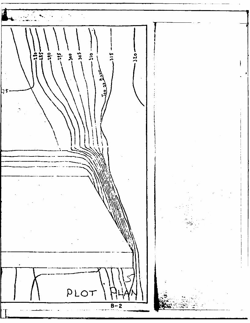
During the field investigation, dwellings and highways located downstream ofthe dam were identified and referenced to the channel invert. The cross section locationsused in the downstream channel routing are shown on Page D-2, Appendix D. Theimpacts of the PMF on dwellings located downstream of the dam are shown in Table5. 1. For the purposes of this analysis, a danger of loss of life was assumed to existif the computed PMF water surface was above the first floor elevation of a structure.This situation occurs at a substantial number of structures (Locations 7 & 8) as wellas some small roads being overtopped at Location 8. The potential danger of lossof life and economic damage is substantial enough to warrant classification as a HIGH
5.8 EVALUATION
The spillway of Burt Dam will safely pass only 10% of the PMF without overtopping.The spillway, therefore, is assessed as inadequate.
ETL 1110-2-234, Section 5, gives the basis for determining whether or not aspillway should be classified as seriously inadequate. The results of this investigationindicates that there would not be a significant increase in the hazard to loss of lifedownstream from the dam from that which would exist just before overtopping failure.This is illustrated by the elevation - discharge relationship shown in Figure 5. 1. Theincrease in flow above elevation 304.5 ft. (MSL) does not appear to be significant,therefore the spillway is assessed as inadequate. Potential problems include:
a) The danger of loss of life and economic damage in the harbor area(Locations 7 & 8) downstream of the dam for floods in the 1/2 PMF toPMF range.
5-2

£0
X IN
4- -
4-- E 4.
u a a a a
-j
N0
00 tic* 0 ~ 0~N N
0..0
00
-C E
00
Go WN .* Ub'
%,6 ..e 0 0 0
r% '.00

3 19. . . . . . .. . . . . .. . . . .
317 . . . .
S317. . . . .
.LU . .. .. ...
315
313
.~UR DAM ... (.Y.75
P3S11AM ISETINRPRLu . . RATING. CURVE
DAE JUY .98 FIUR 5.1. . . . .

SECTION 6 - STRUCTURAL STABILITY
6.1 VISUAL OBSERVATIONS
Visual observations did not detect any settlement, displacement, tiltingor distress of the dam of appurtenant structures with the reservoir at its presentlevel. There are no adverse conditions which would affect the stability of thedam at the present time.
6.2 DESIGN AND CONSTRUCTION DATA
No information could be located regarding the structural stability of thedam.
6.3 OPERATING RECORD
No operating records coujld be located for the structure. The sluice gatefor draining the reservoir cannot be operated in its present condition.
6.4 POST-CONSTRUCTION CHANGES
There have been no post-construction changes to the dam. However, twoof the three turbines have been removed, and the powerhouse has been abandoned.
6.5 SEISMIC STABILITY
The dam is located in Seismic Zone 3 and, in accordance with the recommendedPhase I guidelines, a seismic stability analysis is warranted. This should be accomplishedby a qualified registered professional engineer and should be made a part ofthe record for this dam.
6.6 STRUCTURAL STABILITY ANALYSIS
A structural stability analysis was conducted for the typical dam crosssection. The results of the analysis are as follows:
Case Description of Loading Conditions
1 Normal Operating Conditions, reservoir at elevation 297.0 MSL,full uplift, no tailwater.
2 Same as Case 1 plus 10 kips/L.F. ice load.
3 Water at 1/2 PMF elevation 311.53 MSL, uplift as in case 1, talwaterat elevation 280.7 MSL
Ii -

4k. .
Factor of Safety Location of Resultant Factor of SafetyCase Overturning From Toe Sliding
1 1.54 13.8 1.082 1.33 9.82 .963 .95 -3.10 .62
I The location of the middle third of the dam foundation is 13.67 ft. to 27.33ft. from the toe. A factor of safety of 1.5 for overturning, a resultant locationwithin the middle third of the foundation, and a factor of safety of 3.0 for slidingis considered to be adequate by the Corps of Engineers guidelines. Therefore,it is recommended that an in-depth investigation of the structural stabilityof the dam be conducted. That investigation should include the following items:
11. The reservoir level should be lowered below the spillway crest elevationto permit an inspection of the ogee spillway and the rock at the toe ofthe dam.
2. The actual magnitude and distribution of hydrostatic uplift pressures
I under the dam should be determined by installing and monitoring piezometers.3. Core samples of the dam and foundation rock should be taken todetermine in-situ material properties.
6-2-

SECTION 7 - ASSESSMENT/RECOMMENDATIONS
7.1 ASSESSMENT
a. Safety
The Phase I Inspection of the Burt Dam did not reveal conditionswhich constitute an immediate hazard to the human life and propertyof the downstream residents.
h From the available data the total spillway capacity is capable ofdischarging 10% of the PMF before overtopping of the dam occurs. Thisspillway is, therefore, judged to be inadequate.
The structural stability analysis performed as part of this investigatione indicates the dam has safety factors against overturning and sliding below
those recommended by the Corps of Engineers Guidelines.
b. Adequacy of Information
The information reviewed for this Phase I inspection is consideredadequate.
C. Need for Additional InvestigationThe following investigation is required to be performed by a
qualified registered professional engineer:
1. Investigate the normal and seismic stability of the damand spillway.
d. Urgency
All recommended investigations should be completed within 12 monthsof notification to owner, and remedial actions resulting from these investigationscompleted in the subsequent 12 months. The remedial measures or actionslisted below should be completed within one year from notification toowner.
7.2 RECOMMENDED REMEDIAL MEASURES
1. Implement those remedial measures or actions resulting from theaforementioned investigation.
2. Replace the missing floor grating on the bridge across the spillway.V 3. Paint the bridge across the spillway.I
7-1

4. Install handrails the full length of the dam crest.
5. Repair the gate hoist controlling the reservoir drain gate.
6. Install fencing at the east abutment and post warning signs at bothabutments to discourage trespassers.
7. Clear debris and vegetation from areas atop the downstream faceof dam and from bath abutments.
S. Implement a program of diligent and periodic maintenance includingbut not limited to: operation and lubrication of the reservoir drain,patching spalled and eroded concrete areas, and clearing debris
4 and trash from trash racks and from upstream slopes;
9. Develop a formal written downstream warning system to alert theappropriate officials and residents in the event of an emergency.
10. Develop and maintain a program of biannual technical inspections.
r -

If
II *
K
~I
APPENDIX A I
V2rSUAL INSPECTION CI-IECKLIST4
II1[III
*1I A-I
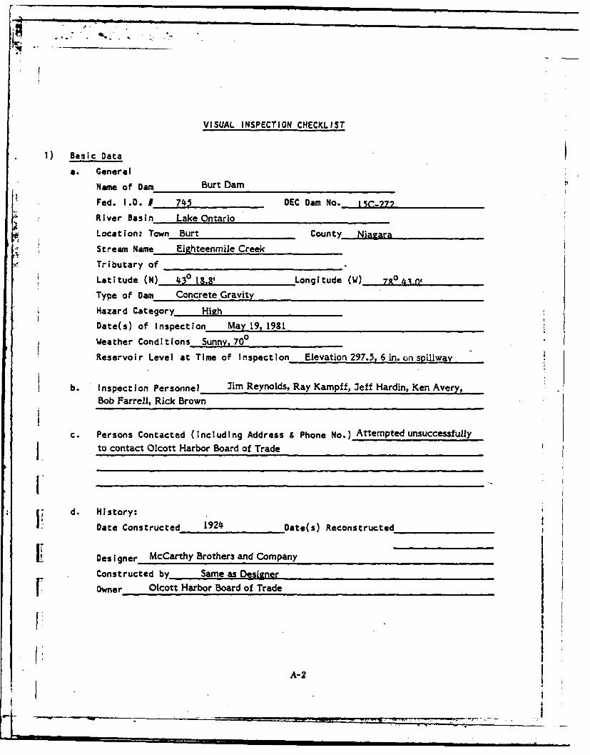
VISUAL INSPECTION CHECKLIST
1) Basic Data
a. General
Name of Dam Burt Dam
Fed. I.D. 1 745 DEC Dam No._ 15C-.77
River Basin Lake Ontario
Location: Town Burt County Nia2ara
Stream Name Eighteenmile Creek
Tributary of
Latitude (N) 430 18.81' Longitude (W) 790 .n,
Type of Dam Concrete Gravity
Hazard Category High
Date(s) of Inspection May 19, 19810Weather Conditions Sunny,70
Reservoir Level at Time of Inspection Elevation 297.5, 6 in. on spillway
b. Inspection Personnel Jim Reynolds, Ray Kampff, Jeff Hardin, Ken Avery,Bob Farrell, Rick Brown
c. Persons Contacted (including Address & Phone No.) Attempted unsuccessfully
to contact Olcott Harbor Board of Trade
Id. History:
Date Constructed 1924 Date(s) Reconstructed
I: Designer McCarthy Brothers and Company
Constructed by Same as Designer
[ Owner Olcott Harbor Board of Trade
I:I
A-2
"Ro

q) Embankment Not applicable
a. Characteristics
(1) Embankment Material__________________________
(2) Cutoff Type________________________________
(3) Impervious Core_____________________________
.0 (4) Internal Drainage System_______________________
I~~~5 M iscellaneous___________________________
b. Crest
(1) Vertical Alignment___________________________________
(2) Horizontal Alignment_______________________
(3) Surface Cracks______________________________
(4) Miscellaneous__________________________
C. Upstream Slope
(1) Slope (Estimate) (V:H)____________________________
I ~(2) Undesirable Growth or Debris, Animal Burrows_______________
()Sloughing, Subsidence or Depressions___________________
A-3

(4i) Slope Protection___________________________
j ~(5) Surface Cracks or Movement at Toe____________________
d. Downstream Slope
(1) Slope (Estimate - V:H)__________________________
(2) Undesirable Growth or Debris, Animal Burrows_______________
(3) Sloughing, Subsidence, or Depressions___________________
(4) Surface Cracks or Movement at Toe_____________________
(5) -Seepage__________________________________
- ~(6) External Drainage System (Ditches, Trenches, Blanket)__________
(7) Condition Around Outlet Structure____________________
(8) Seepage Beyond Toe____________________________
e. Abutments - Embankment Contact
(1) Erosion at Contact____________________________
(2) Seepage Along Contact___________________________
A-4

I) Drainage System
(a) Description of System None noted
(b) Condition of System
I (c) Discharge from Drainage Systzn
.)~ Instrumentation (lomumentation/Surveys, Observation Wells, Weirs, Piczometers,
etc.) None noted
1
i ) Reservoir
a. Slopes. lenerally good condition
b. Sedimentation Could not be observed
I c. Unusual Conditions Which Affect Dam None
-) Area Downstream of Dam
a. Downstream Hazard (No. of homes, highways, etc) Many structures In Olcott,
See Table 5.1 for Summary of Downstream Impacts.
b. Seepage, unusual growth Many trees in and along channel
[C. Evidence of movement beyond toe of Dam None noted
d. Conditions of Downstream Channel Rock strewn, stable
A-5

- - n ;I _ • i
Ii
Spillway(s) (including Discharge Conveyance Channel)
Spillway could not be inspected because of flow over it
a. General Side walls are spalled
b. Condition of Service Spillway Good based on what could be seen
C. Condition of Auxiliary Spillway Not applicable
d. Condition of Discharge Conveyance Channel__
Reservoir Drain/Outlet6' x 6' penetration thru
Type: Pipe Conduit Other pWway
Material: Concrete Metal Other
S!ze: 6' x 6' Length Approx 40'
Invert Elevations: Entrance 252ft. Exit 252 ft.
Physical Condition (Describe): Unobservable XMaterial:
Joints: Alignment
Structural Integrity:
Hydraulic Capability:
Means of Control: Gate X Valve Uncontrolled
Operation: Operable Inoperable X Other
Present Condition (Describe):__ _
A-6

-- I I I
4, Structuralj a. Concrete Surfaces Spalling significant on crest, spillway sidewalls and downstream face
b. Structural Cracking Minor
IC c. Movement- Horizontal ; Vertical Alignment (Settlement) None observed
*Id. Junctions with Abutments or Embankments Could not inspectI
e. Drains -Foundation, Joint, Face None
If. Water Passages, Conduits, Sluices Could not inspect reservoir drain water passage
f. g. Seepage or Leakage Seepage observed along west side of west spillway side wall.May be ground water.
h. Joints - Construction, etc. Effervesance observed along same construction joints.No leakage.
It i. Foundation On rock. Could not inspect near dam due to high water.
J. Abutments Covered with earth, trees and vegetation
k. Control Gates Inoperative
1. Approach & Outlet Channels Not applicable
A-7

I pi
rIm. Energy Dissipators (Plunge Pool,etc) None
n. Intake Structures Not applicable
o. Stability Good. No problems observed
p. Miscellaneous
10) -Appurtenant Structures (Power House,- Lock, Gatchouse, Other)
a. Description and Condition Power House abandoned but in good condition
A-8
I,,
II

* ~-' a
- ~*,
A
APPENDIX B
4
ENGINEERING DATA
II:11
Ii
'.11
I ___ ______ ________
B-

Ia
.1i
1* 4
IO
1.. .... 0......I

7.
rr77 r.:' M- F 60.I
M7. ..
Slo . S4

* . *. . . . V
S .p. 5';
* . 5. . . .5,. 3
8,.
5 , . . . S -
* . . . .. .
- . 4 C
a - .5 - . .5. .3
- . ........
* .. -
* . 5 5. -.
C .
.* S., ,. *1 -- S
4-
SI I
* . S
S . 55 . . - 3.
(5. -~N* *.* -~ . ~ *5' . - -. 5
______ I..ul4~b*t'I) . * \i...~ r~, .- *.. . '-p
I LI - -
* I. -'*'* I'4
S . .
LIV ttO~ 0 5 ~ . , *SZ:* . 5***5 . ..; .' S.
7..CLIv. 3
~Ta~
5t*~* -'-. . S *'
- . - - - S - 5*5~*~5*. ~ -.-------.-- 5--- *

i|- ii i,
.E." :...: ,. .., : , Os..0 , \
• .. , o • . . 'it-- e
, * . .J -- * ,.' : .....
* . . *
* .5. °
* :Ij.II
.. r 0e 0.
.0
P LO-0
B-

- i
117 "_ __'___.
S-, ,- -- =-- -."
.-- , , I '- I - '- ..
K .. "
:! /i SPI>,L LWAY SECTIONVa -,
ii __ 4*'J
AND _. ..... A
~ L 1 _____________________
UPTIA
OT*

I..
p 0. L. rxN
# . .-. .
_ _ _ _ _ _ _. ...... .~4
P___ AMI ELr -, )0t

; IV
... : .~ E. ,.v o
So .N ROKOt50RcCE
14'~
* -.
4:V ..
* .* .. 7T 7.,
*fA SECXION

A@ I
M-^tH -e-a 4. Fa v. o
~R'~L Ph NhA DA m
rlyOTECAI 0O-ftDVEO MpLO Ki R4 EFAEO JI . -lLIPL-CO
ptrE .2.a Ci 5 0
Do ^vIc AJ i4I(~d iO ~ ~io A
* - ltvaO 4"13.3 z~b
Ii' I
II
II
APPEN DIX C
I 4.
PHOTOGRAPHS
III
4I.

IMz
I -J
I -ad
.. 00
IO
I _R
Wow4,l

IIII
II1 1. Upstream impoundment
IIIr
*
I
I 'III
III
I2. Downstream channel
I (~5~ 9 __________
I1--' -- -

WvF'
III
A
I
II
II
I 3. Stairs at east abutment
II
IIIII
4. Abandoned powerhouse
II
Li C-3 ____________

- . 4
______________ ...-- .
UA
4,
II
-j~ '~
I5. Sluice gate mechanism for penstocks
III
II
I UI I
4
I6. Bridge across spiliway. Note missing grating.
.1 _____________ II
C-4 _______ I

7. Dontemfc fdm eres btet
- .-5

-~
III
$1
II1 9. SpilIway
*1I
iIII
1 10. Abandoned powerho~e
C-6

11. Wetfc fws plwywll oewtrtikigd w
12. West face of west spilway wall. Note wae trcklingedow
face of da7
Iiimwg

*1-
-~ 4
I~I.1
I~ I
II APPENDIX D
I HYDRAULIC AND HYDROLOGIC COMPUTATIONS
IIIII
II
IIII
I V

I.I
APPENDIX D
J PAGE
Cross Section Location Plan D-2
I HEC-I Dam Safety Version Computer Program-Input D-3
HEC-I Dam Safety Version Computer Program-Output D-5
Supporting Calculations
I Hydrology D-21
0 Spillway Hydraulics D-29
I * Downstream Channel Routing D-32
Checklist for Hydrologic and Hydraulic Engineering Data D- 34
I
I
II
iI D-.I
i

Scae:1l0,
Ligh To

K4 In I. In- --
I-AX- 3
z z0
Kc z
4 0 - C 1 ~ CUs = - i on i f C
CLU 01- 2 O lt C
U. 49 -C9i
tF -9 040f a o c L".) 0 0C-N C. m n a- C N i
P. 2 . 0 C-4) Nl y
W -- -9 - ! n?6A4 0 U) -U L. 0* t -, W) 0 .4
-9 .21 6. 0 IL 4z K) W) W,* CU)a 0, -9 aA 16. C e..-
U w-l M C, C 6 a4
a P. P. I o 2 Cot-oa
I0 I0 a.N 0 Ci 6AU
10 02' 4 0 .4 a, of teCL GO) ,L U: 0: P. N w w a
ILI It a fi K W4 -
~4 03 0 !2 0 0 008.l U. IL Ur 0. C- NW) -W) I -
0 IL IL w *N -CiO C * .0* & i 4W 4I - a
6D NN 0I ka 3* U. W) ~ - *ifiZ .9 l-N IX 4110 W I a
aa
W_ -A 60 P- u- 0 '- w '

.4.
C-1' 11,.
Lnb ndO1iV 10I
InN 4C yC
vC0C Dt 2Nc ~ c Yc
CC 1. .0 C., -in4N0f n W)C tf N n Yf N C4 N
- = a 0 a w , a aaLA ft 4 N %A W 0n- NIn Y a~ W
CL 4.n Wn 9 iA 0 0 9 0 n in a wa o
ac a. CL -. &
x a W% 42 C4 in4 )W I i ,l
aC Nb 0C w Nin NaCD0-r%
N 0 I a w on at a m o 0?
CA ac aa at a0 at a I -
inI a e a a r ai aC C a t
*u~W ati Q4 v ~ CeCP~ ir
2- 1" 3".1 ... CON x pa 1-. xtn P.. 31N b.. 3CC V. 3e
- -C4C N 0 C i C.C O~n U Q~ C ~ .C N-4i
Ow4i~nV."l in-CN CN i ~ i

- -'- 4 in
jLj
I- I*U a
* X
-c u
a 4
C i D.3 wiala
j v3 a.
cc cc o- Ix I-'c%ro xa o lIl6i K ~XX X XX =.
u. a~ ccW a-a zIz 45 r, a, ac w a o : o
S.- X~i~ x- a-
P. v. v.P .3 -D-c 6
wi x a U
a 6 agia-2 a
Li-iu. i- . 0Z w w 9
to a zt - w o-. o* $- " Pmnzao~a.Cz=====Zo-
n
I aaCaOOOCOO ata ag6
0 0 egargagoaAaaa o- .. It
~~~~ aZi 3.ZZZ Z Z in~a (A.
31 ~ m. IWOa vi. ccJiw~~ 3 a c
4. ILa
~..~c~o~eOam-O o o n,
Li CU ai
a~~~0 a -w .w-me a. -z w. ea X
*0 2 ai 4 Cc, x x
i-p 4
- C4

0-
IL*I
do 41 I a 0,m.6A 4
C, 0 0
to -jf
444
w --6 t d
-A ac -I
41 de *9C4-
0 i~ 0 4 mA N~fl t -4.1
a de 0o a - ,
1-. CD cc 40 ft eP2N0- .a
4-
1- 41: 14 0. -Cl -
o-0 C z9 "9 9 ca A - m
29 0 09 zU IL9
0- Q 4r n c M d .I
Cm m- - I A 4 CcV c-rn UV 0 j om2~0 4
W 1-0 &"0C
1-0 V) C. I
CC M 41 *9 * A IL a. Co
-~~~ F- 1L.~fN-N 01
lo0 4z m -C 0 C0I
ON .. J
cc 9- 1: N: NO W) c C z . 1
cc a. C U) 40 4 0 X
IL M I. * C. - -. * 9 * I- on
0
~~~~~~e op1 449 .j 2 U -C 110 4
4U eg 0P 20 inU ev C CU I- C4 a.
EU~o on a- V)a.C 26 6
0.0 4m j 0 .
40t
c 3o or ona00
.0-1 a.' em9 4 * 40 .
4 I-mD90 - 4 -II41- ~6 1.4 4013,fNN~
U
I ~ ~~ ~~ ini O2
0.1
444
4041* *0
MW 404D-6

a..a
-M 9
j - 49
Zj 40 a9
cu 4 9l P-a 0 AL 4 a be. 9wcc 9 .4 cc- xJ 0
H z In c 96 -- 4 :C4 rm P - 4Y 4L a l
-C 0- CLj~9
ja bl C4 x C4 2 -
0. 0j LJ 99 2 L -
-9 La 2,uCL cc 0.
-4 C 4
0 1
z -9 B . x41 u4 W~ 0 ba 00 pC
ft~ 41 . p-Cz 4.u 14 - - 4
9 IL 4
9. W -*lIJ a~a 9 i 49 X b.9 W3 CL h
0- P- IC- IC4 20 4 4II~~~V 40 w 1 4
00W- 1; hi a LA
9~b CL9hi9 0
It 0
4D r %a 9 994p I:
La @04 9- a 0- 0
96 011UI 0
D-7 41 9 9-

-Pwe
W 4rm 6-0 NCf
4jO 40
o2 *u0 C.U)z C0U0
ft C2 u0 If ca I& f
t- -:0
oe 14 9Fmc 0aCa LIr
ac.
4*1 d o C 0 a. D C i
-9 a-
LI -C6-C
wl 0. 4 Cac~ 42 x. b - ! V
14 J INC 4a70 ID Z N. 1" C I) " *
IC 1-4C
IA .9 1 2
-0 00d 4 4 4If. 0 CL
4 0 ,9 'a 4.2J 11J a6J91
- w V4
-6 00 a
4 yCO . 0 -
CL f- C t
1 -~ I t C Ch. . 247.z 7 - - = .7
z 6 C.) . C 4 04 3
j . Ide 0 7 07 .x
L. z.L C: C!LIW 3
W- =Q Cy4-0
11 If C LL I L 3cQ
Q.a 40 29' 0 l 09
II co k..4 j a .cz u
is- I to
44I- 4Li 06
C 4 40 W- W .I2nwPM 9
499 in0f 0q IT41
LI LI
to 000 1-
C
0 Gn 9jftat
000
fe In
0 D-9

II
61 40 61'4
4r IV
&0 0-- ( D (L'm0 o C0 K "' I* . I Js-Li ado j4 co.
- F-CC
AL C,.IN.C
M0 CY N ft 6 -
In 00 4c GnCLo .n K cr C%.aF
Fto 0 0.0~- :w z co0 0. F-C4
In 29 = " -i0 IN,
V, fo V) i - 0
- 2 40 C',C.0 4
0 040 I* .r j . W
6(n 144 U, C, U, ml~0cm co co th W) w W 61 w 6a 44p I( 02 2 2 61 0 U
IIN ~ 0 0 04 00 u
6-1
0f Q0 03. 00 it -A a4 : : , :
c 2 m m 2
- 4 P. a0. j j j jL C
w cc f0 C -j 0 Fis6 6 0 N a- a0 '0
ka -4:9 :9 :9 x w :a 642 A - lC - 4 40 61
IL CL L aL 4. CLz
D-9 222 S-
U * 4 U - F a a a a a a-F-

Irme em4 cmr W) Upa
*9 c . 'a
0, ~ Cl rm r[i meN, 4flr P- U op 0I.I 4
I" 'A- 1 0 4
a It
4l 0
on * . w) P. *0 *j c W m.
Ina, I 0 4
w a.
n t * 0 u -
.j.. w
~ ar toP 'P PI- a, 994£0
wi * 9 . 9 9 9L Zc ca0
00 Cr ~ r- t 0 .
m)9 n a0 00 0I- Z. 9 0)r: ftP) 9 .. # . z
o. In '4o 1. gW
0 ca0Nin: 0 A
000 00 W -A O l N1
I) l
%* In 00 'a
44 on4 . K
40, 0 ~t K 2
I ~~ D-10 -

I4 I[~ ~~4 44- v- 'In'9
do a , * p . orP 40 a el m 4o 10Ww
I.. wl I.. na~
17 7~ p.0 1N a. c
u, = 4 -*J ..aa a.o pw a, - t
PP 04 PiNul
P-In I-.
6-j op. Iva w' tV'I aN lowd
cm ew 49** *100 -r p. 0 .. .
lo
W -Po -pv ;. S. a
x -m
op. .ma m a9
mc a co. m a~~
0 aa4 '
43 4cL r
C: in f a ccw-a. mn -Ap CC W ) 3.0 a In
-m w. 4M -c 61 6j A- N
9N Nie -lo %a- a
4r v cca
42 4a jJ 9D
'r7 op "c. a'. o. 6J0 PI)
W) ko*0 n n0l Waa n 4a0W
* .. J~~~~A .a op .jK za u a i0
* a cl Z c: ja
0 a a maa- 9 K U a c
Ii4 m: 9 I9J 41r 02I 9
*D Inv Ica a, 62 .Jmz
UN0
m~~~~~ Ia 4N 4 i . P9no~ a
D-1 I

em in cm P)a A w
a. .. 'a .. . .I i i 410 7-a 4m0CO
C 0W - V) VC In4ce'a a e'0 )C 'a
C: I, * **.
to- - '~- n
Fe F IFe Pi.
iLi inc iDe wE
ew em cm w-0 c
C~
* m. a . . . . C )
W... N4.
= cc c a. a5, aL
a-L
,a . U'a0 La 0-C w w"o
*9 IC 1 C em N
mm~~C .oe Ce-4 - '.
o-n 7-UW) 7n 110V W e.
P.V In r- 1 0 L W -1 2: 61N ) ., a.mQ ma V) W. =.i. .. -C:
ON -aC -w w I. W) a. IncU) 4 ' W c
ca 2 0 c0 )C
W.0~~~~~V alW0a 0WV n 'U
.07.~ ~~~ 47 a E UO UC~~~~~~ C4 0 ) . - a7
on i..U CPI U)i j0 (ANV%a In P- %aO W .Ii 0
r C7 ft 7 z WO 01
ma' wnV of f-~ -C i.
N4 0." 2: 0: 2 mN N . . ) w C ;I 0
11 el '0, '0 V0 7: 0
11 10D ID #a $a '0
AdI 2-j 1
J~~~~~C I J K K £ K K KS4 -
ii. C C C C .1D0.12

-. ~~ -. -W-. -, '
r- 4 4r- W)40 00
em n n
fyA a0. OF- 4"r.0 0 N
I . C4 cm**ew. tv n = -W Sii F- S
inA clo on OFwl 1- -N 0
F0 .00 Ay 'mC et N
- 2 0 0 -a . ' -
C. CU 0N 'a n f
NC. 4N
.00 ae In %M c C wC Do, ) ft0 o
F- -A - ) NO 2 N
20) 0 Nil)4
F- n 0 sO )
0)0 F-....j
le 'a 2-.110'~~~ _j F - e .0) F2 ~
02 a) 0c -c 'A c: gIN n-* * 0 0 Z00 24 0
NV)~ ~~~ 20 O 2J 4* I.10 i)- 04 VN.110~ ~~~~~~~~ kN0 nU 2 .. - ~ C Cl (l) 02 4
ol. . .i F- x w * l
F-~~c 85 0.0 a. F-N 0) N C '
NN 00 0 .17 4 N. .
c4 04 00 aA vh w cs 5 -C'a 0l Ln (AC 0. F-(A- '5
6U N 0)
24) ~~ ~ V c:4 A JO0 5.0.1 a. N-) v) f-C ) 04 C .w
c. v - l. I)
eyF aD4 &. $A. vi v0 v).f (A I fF- F-l - - N I- F- - 0
-. . .. o - 0 *
W0 0 1 F- 0 U~ C
I 0400I 0 0 ' . . )~02 a. x C v 3L K.(V jF ft00* L c 00 S 2 F .
D-1

W 11'.n hi( P
ax * c i n w u-P
a em c, e -
'Ic ua* , **
a -- - ' = 9
P.. - C4It V) .~ I :. o'a NyP
0.3 -
an in y P, ax in- m 'nU m
IIam
Nb x. m a 1, a N
-A M
In7. Inc4- Fni In..
W= A.o0 inP to*~v
- w,4
o L0 xi. x c- Ow. N y NNf u
IL Iooo (D . am : I
o z c a c. v)aN 6AK C cc % a =fl 20 se ft em *P o -r e:
)- 4 W . Lo * y P. r. . *I, 04 0J .J C- C 4D Dc
0u v) .0 -n - P -
0~~~P Zo 0 i-aam W WPO
Lo 0. v) C C~ .. . .i-i a am --~~. z Ii ema ~Iia
V~~~~~~ N 4CS or o ~
U 610a N N
j. W6A cC 4I p a a
cpI .8 cu
.80 .. 1
4 2 2 2 P. 4y as
IP M6, -. . W------vv

-A mm m Nm
W 4r
*l * . . .
*~ W) V- W
Cl w
*~0 4w N . eI- P
* - - -4
IL I .. CIO ft; 4CD I0 Nm. CY 0W
rnw cr c 0. '4
a ~ C x
p- m C.C
cc WOO P-.- _A 2l W) P W)rac ,, 4.5 C 6 to ey * .. *
C; 4W - 00 nW .a A~4 In ee
* . A z.J .. C4 l 'U'a U N 'n 9%w j.0 'aP P' 4 U P. W
CL 0*z I .m e .. NW NP
61 -1P ..~ .6 4 *4 4 -N*Q p-5 4.i 1. 40 a-04
.0 24- F0 C- C4 r nU4-12 -Wn C. wna N
V, ua (Az2Y
V) N: C oU 4Y * - -O Cen en en en en C Or .a a
10 " no 4p N
1"A 1, 1. 1.0* P*~1 4 .4 4
611
%D w p-a i an-w
L" P- F -A 4P i- %D 4r
onP 40 WII cu 4
-
4r .- . . 1. . r-
eu 0,'a CI ey 'n D
W* f VW N WWI "g w-,o vi Ca*,'I P2US C N
*I up n W
a fa0 W, wa W, w a
-C 1. 4
4' InI P-. In W. k"C
f- to C4LI cun tot.aa . W ~ cc
eL Wa CD C C cal i
ta a *-
-C b-o ua ey N
0 0. C, a n- ato'~ l- C* r496 9 in in a m In 0 c C0
2-~~~N dcWw YC4 %0 C4 j
V3 a WI
-J CL Q- =N NNW.a ,sa aC a'm
2a' C- era 6Cayl* 0 In4IJW a,. - Ia ftI* 4r o4 1 ,0 P.
4D 'n . cm~ a, W3 ata a. P0. -* Zc4C
Ln I CY - m
6J -n PC UNN aCi NN In n'!: Ln I: :: 2 In 2Wtvw
U' I Cn -- a-=e v
LJCC 21 cyc C 4a,4
z ca w .. ...... *114
CaPz -. W -AN PIn onW in N-1 1O 'aa N WI NY N
WI WI AD ts la C. * c
I we am cc .a . . . . .
le It M a X.C U.WI PWIIn = I WI = =6 =IC =aN N I I W
%%j 0a WC ,a
06 WI I T-
K S 4 .. j 4 .J a a. Da.16
-. 5 . . .l

V: -r -'A 't 0, -. -4- ' 1' CO W'
61 oV- r4 - - f do W 4 d* ID W4 -n Ca C &*1 a .0 Uan 4r W. *n 1- 4r !: 4* 4* 4 .
IL W u On W~ go~ 41r aW @0 Wa 4 N N c' ca a, - co, w N C -44" 61 FA u'a .'.4n a- W %0 L a ,'en n 0a Ina CC n W e In u,% 0 en
m 00 31 'a, in en a ar 4a a a a- 0 - - - - - - - -
c - = - -, a, -: W -1 1, 0 -1.0 -1 -A
U1 61a 0-s * n *1 Z ** L* V, o* * . o *
* ~ ~ ~ C tic 00 to * ) * o go In * - 44 0 44 .4 , d*
co W cnWb 6 .0 n c a in% c ccc oo wa, -nm r*r 'A WW 6 - .e - -
0,a~n 40 * 40 in * n * * * n 4 .*n--a4w1.1* em. -Go - - - - 'CID, r - -I- a 0 .0 P-a P'SN CMa Nin .. c-4 .0 P-N w)a ew .N w'f n
ac z .9l W-* .- . ) W s. . a, a-v N a '. Wv @# WNF.000 N* a. 0 '. 0 . ,S . 4, n ~ . ~
~~4 00.0 - N. a.a!. a a : -
. a" ? -- -N NW N W WSN AsN Wn W5( W5( a, N a N inP- Wen W4 C r 4r in .0 N a. a', a' r' W' 0 N 1,, 14
-C e.)e ev 0 ko - Y P- I- F- F- -
A1 0# en- N a' 0' Cy I ) O C N ua L7*MI r:.. a c,.4 I-N It 0 W., 41. 00, NP- 0- W 4 . ) ,
C6 a 9' -
0324
;a 44 (4* o, a, a,* Cr a'n a' c* O n a 0 - a
in .f mW Fn .4, *a W. W# a. 1 44 4. .
.0 V0 0 e en on -a ) 0 0 P. r- M C' r .
a *Y
*~~- 0u Fn -W 1 4 N 4 n .
6A L 1 1 61z L
:40C- I0
e4 - '- - ' h ' ) ,
fa cm K 0 0-a a .. IL
4 U K a a aa anP: P:
I-rw o lbwl w
0, 0
31 31 o yK Y f y0 e Yr-~~~ g 0
tm wbWNt
w U)
N in. m V
*~~I Wb .KUU:.l0NI Z. .- NO "a, I- UW) inf D a .0 NW V f 4) Lm 4
, fa IA -KOU
* - I C4~fCV.f - 4 ON ))flf 4O.9~ ) f. - 4 M~ N0: ccqa ccNI 4 xV) -~ a41.4lb l
N * 4 4 . * KU a 2b
F. C.P-~K ~ c a0 0 0 00 0 C
NCf4f~ ft''a a-N ~ .ZCin e~j 14 4r 1.I90L O N f N4 0 0 .4 0a
- a.~ -a. .D-1**

b- 4t I ' .c
Ir : I1- *InI --cA4 :r o4 ;wIA4 nw lw
wl l %A o D 6 InLo n t 0 a 4 w n I InL:N1yX( 4f yNNN Nx( y4 uc ye w yf yc tQcc - Ixo x-
Bus 4m fnm a mL(4 m m m-mam m ~ m a
mo 1 Z .4m m K~m mm 1g Ina mm 40 P P . mn m 6z P w
1! "o rf ItKr r I nI oo 4 t1Zc~ c,10
Km K0 ft w)JWP in *#ilP N *?fat ::N Q K: omQCJ
I D*6A e-K- e7-InInI
W. -5~6-5usa~ nI
I~~~~~~~~~~~~- 9.Kn... Kn*C* K **t Kn*** Ln

II
I!
ow Nev s
e W$ol-
0 ~e w
lo I.0 ; i
00
.. 00.0
400-
1)A I r ERDMAN, ANTHONY, ASSOCIATES sHEE.T /OP /LDj39 DATE r./,K sJuaJscT 17PAM 4S //b6A SUEP-SHMf NO./
01 IL/''c&/ 1
-s-i
IA
2 ))
-. "b Ava U4 L k PA
A--
1- e , S - c /
D-21I~ ~ roA 7--~ (Ad.

f . :I DATE ERDMANf ANTHONY, ASSOCIATES SW6 OF
Dw,~ ATES/o susjscT)?1/-/ 727'S-Z:c' e, sU&JHESr NO.
OWNER PRtOJECT NAME t, r- 1 6 0 0, ' 1)
1,
I ~F eo 10ri' I Fr.
~~3j~ZV) I 'rIA A roA1-~4 6E L I O
L Lr:- vr L2-7 )o
~.C)IQIc27, :Z 14Z c.~C E r. r o 1A T- o~r )~!JC
I'1 A - iA o ri )e I L l- r--.e ---G V-
Lc LC'~ I=-A 1
D-22

~.L.~.DATS ERDMAN, ANTHONY, ASSOCIATES Sw6ET 3 OhAV~eJA/WISUE-SHURT NO. 3
owNERt PROJSCT NAME Ajr' t4~~i)
IF
ILCe L)Pr1 .mWV7-1t
L L , t'r~ja mz-t i- A MAO O M Xr--Aa vt. V eA. '7 ?0
x ~ zooc .I)O4. P', C
' LO C 10 9 r J.
WI LG E- VOOO /I
MAPLeSMM x 3,0
LcA b--kw,,c zr- 2- 6X O D-2.400

Y\ DATE S '- ERMN ANHONY, ASSOCIATES sWEE.T OF /ID R4 DATE su@JET :2,4A' 7,/S SUs-SWEET NO.
OWNER PROJECT NArmE Ap i'c'7" (~O1
-:~t1Air f~ .5Ksy.VE,'f' LA'Z
rp L
L~~~l I-- 4!Foc S
IT
4I sas
D-24

SY j~*~DATE ERDMAN, ANTHONY, ASSOCIATES SMEET 5OF
IKOY_ DATE SUJC74/7 4 411 26 /,L, SUB-SWEET NO.
I ERPROJECT NAMS 4-4 40/;,- - ./
S~I
1I2 o = _- __-_ - V "L/
L g A e- o S
o-3
7 U + . 31
. - - r == 24000 /V/ -er -s=
I I I -. 5
S - 0> 3 S± 0- b r
I U6D-25

*1
'.pDATE /.~Z ERDMAN, ANTHONY, ASSOCIATES SHEET of:/*Ko DJ4 ATE /~e SUBJECT ]2i/ - > /I SUE-SHEET NO.
OWNER PROJGCT NAM )/a1iGL D4"",~1j Ajj-:4s
0 o
A.4 z /-3.J
7 1.414
Ai ~
j k- 0- 146 L-9
I~ ~ ' 19 ~<. ( j
[ I-2J

.4-2
Y J. K. DATE r ERDMAN, ANTHONY, ASSOCIATES SHSEET OOF
KD jV~t DATE susJEcT ~ Z< ve ~/ SBSIS O
OWNER PROJECT NAME --
II
i ,t Aeh4 A -as
( A = 2S-2 + /2-OI--3 73.
.. , .-
K - t .- 3i'~o3 = d~ rz. e x,'1
I /
-c 3 ono . NT O ASOIATES
/
I ,4-o.4- 03
! 4
I o.- 7
I ________ I.. "f NINHOY ASSOCIATESSET

.ERDMAN, ANTHONY, ASSOCIATES S66T OF
, AT - su.JGCr P ;4&R- / 4 co/o suDsasT No.
OWNER PROJECT NAME .~, 7't, ~/6d~iAV7'
"IC EI¢ -T'-/1rV14Lut OF k
1 6 01 2-
II0 'oeS4 5375
IIIIIIII
I)
III
I D2
I!- - - -

DATE ERDMAN, ANTHONY, ASSOCIATES SHEET / .DAT .l/(SUIJECT DATE SUI4I.IT NO.
, //4- "s- :
OWNER PwrOJcT NmEG 'Z / />f ./
I
7 i-I I ,
ua I'
. ,1
5 -7._ -__ " !L -' ,k2 -,/ < -"-_,-/
/ 0 9. ,//
2- -73
- '7.7 1, ,"
- 2
I _ . . /# 1 k
t . ...:i7 7-< - '
.:L. / 4 > .
I- /70i.0 '74/(,,
i '' K1 0 z. ' 2. $,s .7 q
I '-'I "<&.i' i
I D-29

"1144 4,
PY k DATEQ 7 ERDMAN, ANTHONY, ASSOCIATES smrrT le) OF /KO DATE 6"'1SUsirCT s .Y A,. /vAA : ue-SHEET NO.
OWNER PROJECT NAMS C'77, / 1 , 1 >
_K
Fv,
-J j4-4
D-3-

-~I7 AT ~I/7RMN, ANTHONY, ASSOCIATES SHT//o -RKO , DATE 4/5Aiuucr4i'- 42-//& susmr No.
II
D--

- DATE -, ERDMAN, ANTHONY, ASSOCIATES SH66T / OF
~3O ~ DATG 3I SUIJICT Lv 4 ' G suD-SwEiT NO.
OWNER PROJECTNAME iAEC- .LZ. OANI
INIz -
1~ 4~
--4
e-c L P irv ''.4v -L;Z CV 6.
j 2c1 46. b Z4 ,
I' 0~~ CC) 0 ~ 1. -32 7 2 ~ ~ ~ ~J

By 3 P - DATE 3 - I2 wa ERDMAN, ANTHONY, ASSOCIATES SmET /5 OF /i
, DATE /SUCT AM 74-S . SU0-S212T NO. Z-
&riftC NAMEa mms . Q DAfri 0r~r~ 1 0 - IO I
I SOL , o -- ,b O .00 ;. -''' 7 . ( -r ,A ,. - 2.,4 .4, 6 c - z z i ,
I
I 0L c -C-) . o - 2 4 -A
. 6 -- A l 0°. '- - .
II
C
4I 4'"' > t T . 2 7 b~ O 2Z 23 - 2 ,4 . 1 ! 5 ' 3 2 -( 2 7 - 2 )
D-3
4r-3

'I 1. - ..
CHECK LIST FOR DAMS £I HYDROLOGIC AND HYDRAULICEN~GINEERING DATA
I ~AREA-CAPACITY DATA:y 45I Elevation-, Surface Area Storage Capacity
(ft.) (acres) (acre-ft.)
1) Top of Damn ___ _ 41 2 4
2) Design High Water J0Z A(Hex. Design Pol ______ --"---'0 -41
3) Auxiliary Spillway
4) pool Level withIlashboards A114 -- _
5) Service Spillway
Cresty~es 9_?ev0 4P1on
DISCHARGESVolume(cf a)I
1) Average Daily I12) spillway @ Maximum High Water //
- 3) Spillway @ Design High Water =2
4)Spillway @ Auxiliary Spillway Crest Elevation &Sf ) Low Level Outlet (edite4 rv 0ro
*6) Total (of all facilities) G Maximum High Water
1 ~ ~7) aximum Known Flood (ObS5v,/eCI Mk aeq-
8) At Time of Inspection 250)
-D--

I -. - a
U.L
C .T: . ELEVATIOI: ,.USgO4. 5-CREST: EEAINI[
Type, e'od rt-'o' 44iWi dth: _____________ ___Length_ _____
Spillover.,_....
1Location 0 7 01--71-(,0/~
SPILLWAY:
SERVICE AUXILIARY
I Z97Z0 ~Elevation ______________
j (o~icr~'af± Type __________
.. ___ _ _____ o__ _ .. v.,,o ,,Width _
Type of Contfol
Uncontrolled
Controlled:
_ _ _ _ __ Type ___(Flashboards; gate)
Number _
Size/Length _
Invert Material ....
Anticipated Lengthof operating service
__ -,______ _________Chute Length ..... . ...
a _Height Between Spillway Crest& Approach Channel Invert
(Weir Flow)
IDSI _ _ _ _
- -I.°*-' *

HYDRMTUI fl OLI ALI CAGES:
Type /1/lowv
I Location: .. _,
Records:
H ~~Dat _ _ _ _ _ _ _ _ _
UI Max. Reading -
I FLOOD WATER CONTROL SYSTEM:
Warning System: A /A.6 ,,
Method of Controlled Releases (mechanisms):
II.
IiAo
1 It .... ... ,....
II

S 4
IRAINAGE AREA: li. owl*
AIHIAGE BASIN RUNOFF CHA CTERISTICS:
LRaInd Us Type: A414 0461410 "
I Terrain -Relief:_______________________Surface - Soil: Afx' a /,C/
Runoff Potential (existing or planned extensive alterations to existing(surface or subsurface conditions)
'I
Potential Sedimentation problem areas (natural or man-made; -present or future)
I.Potent.al .Backwater problem areas for levels at maximum storage capacity
including surcharge storage: ....
I
I Dikes - Floodwalls (overflow & non-overflow ) - Low reaches along theReservoir perimeter:-
I "'Location: A,.4
Elevation:
Reservoir:
Length Q Maximum Pool- Z C. 2 - (ies)
Length of Shoreline Qe Spillway Crest)_ ________ (Ililes)
II ..
I ,D-37I: : :III

- .~
III
I A
II
II1 APPENDIX E
I REFERENCES
I -p
II
[.
I)
III IIIII

..
~_4k
I
APPENDIX EIIREFERENCES
1) U.S. Department of Commerce, Technical Paper No. 40, Rainfall* Frequency Atlas of the United States, May, 1961.
2) F.M. Henderson, Open Channel Flow, Macmillian Publishing Co., Inc.,1966.
3) H.W. King and E.F. Brater, Handbook of Hydraulics, 5th Edition,McGraw-Hill, 1963.
4) T. W. Lambe and R.V. Whitman, Soil Mechanics, John Wiley and Sons,1969.
5) W.D. Thornbury, Principles of Geomorphology, John Wiley and Sons,1969.
6) University of the State of New York, Geology of New York, EducationLeaflet 20, Reprinted 1973.
7) Cornell University Agriculture Experiment Station (compiled by M.G.Cline and R.L. Marshall), General Soil Map of New York State and Soilsof New York Landscapes , Information Bulletin 119, 1977.
8) U.S. Department of Commerce, Hydrometeorological Report No. 33,Seasonal Variation of the Probable Maximum Precipitation East of the105th Meridian for Areas From 10 to 1000 Square Miles and Durationsof 6, 12, 24, and 48 hours, April 1956.
9) U.S. Department of the Army, Engineering Manual 1110-2-1411,
Standard Project Flood Determinations, March 1952.
10) U.S. Army Corps of Engineers, The Hydrologic Engineering Center, Flood
Hydrograph Package (HEC-1) Users Manual for Dam Safety Investigations,!1 September, 1978.
IEII E- I
,I1
'i

4
I'U
IIIII
APPENDIX F
II STABILITY ANALYSIS
IIII
II'
F-i

AT5 g ERDMAN, ANTHONY, ASSOCIATES 6wrlT 0OP
DATE ' - - ilT r -
It ;
di// P A F ) ;c
I OL V
<Z W w
c: --z
I F-2_ _ _ _ _ _ _ _ _ _ _ _

AD-AI05 729 ERDMAN ANT0OONY ASSOCIATES AOC ERN / 31NATIONAL DAM SAFETY PROGRAN OURT :AM (INVENTORY NUMBER N.Y. 7N-ETC(U)AUG 81 R J FARRELL DACW51-81-C-O017
UNCLASSIFIED NLfllfllflflflflflll
11111I1

ByDATE I .- ~ ERDMAN, ANTHONY, ASSOCIATES SWGET -,or
DATm 6 s' u "i LEC ** '.U A ais SU4ls4UT NO.OWn POJBCT NAfM 6 Lr D.~ P" h~A.
we,1-,t 0-2 CO~,c fete -VI/C 0ov'C.
, o Oz 56,, x 140 1
3.0 X- 3. 0 9 . x 3 1 S,3
" 0 y 'A~. 't 6,17 IL
t9 3' 0. q6~
gesj/rrit(1 2 c~ii~'roe) /
I Wocter For'ce pworco ot, u gtre4. Fa ce
ii17 03.~ - Z S. 0) .?2 41
Casc 3 RIC rv
Vc 'e F or c c wr e s o o w v5reo: Fac.
~~~~ Pr1 ,, L F C,
PSI'~"s pt e
I t. _ _ _ _ _ _ __o_ _ _q _At_ _ _
F-3

4. -- I n -
By__H | 01" t DAT 6 - *- ERDMAN, ANTHONY, ASSOCIATES Sudr 3 of -:
iCKA S /, SUIJCaT $ 6,'., ,,_-Su- J.$ NO.
oWNE / / PROJECT NAME c,"G+ O.,-. - PNhAse .r ,:. e,,,
i H.,o :tot; 'yp!,.'2!" Forc &
-IFLi ~'A ~~vi 60,1 /1
3 , ,,
c. se C o.0. 1 sO) Xr/0 .O 06;'9 (3Ii -3 ?.-7) 9o'Y/ ,X 601
3 (P9,-x Af.. 0o,-€+ 30.?3Ife'ulto-,it (Ir?' roe) 3 0._,1 I K q/ . 3o, f3 ,1,/r
30.-~r'v'/,. 3 c'
II
r-Z !e A
W..
i Iece -;€
i ¢r=l, = 4*.I. 3
Z H s. = 'f.,i,,, - 6o~,, t2 .. + I? 2. .0 -/ *lt x g =";f'
I f
__ __ __ __ _ __s,,.~
'II e: ".A,-"I A 3.,*t' 0,,6 " .7I
' .'9s D'.6
_ :LydjLt 9 311.60 F-4
............................................. .............. ................. '. - ...

so D T ERDMAN, ANTHONY, ASSOCIATES SwasT OF
CAI OAT iwwJC 'to4, A MNENO
14.6 ~~* x z97 ?r
1117,.. /y ?1
1 -- 5
0 -~ I
-~G-1
It

v~~I.. '~ DAN INSPECTION REPORT/fC ± L(By visual Inspection)
iver Basin Town C nty Hazard Cas &Ipetor
-~Typ of Construction ~ *~Ue
A3. Earth v/Copcrate Spilvy w . r~ E ater -pp -'
Earth v/Drop Inlet Pip Ef _ .o---
Earth v/Stone, or Rtiprap, Spiliviay Recreation - Q High DensityConcretes Q3 Fish and Wildlifestone Q3 Farm Pond
* ) Timber **0 No Apparent Use-Abandoned
U Other 0____________ Flood Control
O0ther____________
td.iatd impoundment SiLze.? Acres,~istimat ad Height Of Dan above Streambed F_ t.
* . .; Condition of Sp~illway
Service satisfactor Auxiliary satisfactory
n ned of repair or maintenance - Q In need of repair or maintenance
- - ~Condit ion of Non-Overflow Section ~ " /16 Satisfactory . Q In need of repair .or maintenance.
IExplain:Condition of mechanical Eauivment. .
~JSatisfactory 7 3 In need of repair or mintenance
Siltation 0 Hg o
Ramarks: C f #f44M# - A M,44 Awu*eT r ,Ze
Evaluation tFrios visual iseto)13 Re!r*E Id. beyond normalmt . No defects observed beyond normal =int..,
G-2

T/rmo - Masr.I AO
-.- STATE OP NECW YORK; rv OIIN
IlL a.:- ~ .DIEPARTMENT OF STATE ENGINEE mMM6 ~iiVWinTRN DVIION:::,~
)oe~a.'&' ghteen IsROO4ESIM.~:T,; -
Cie CreekL, t Burt, ,.. *
1.; 7 ~r' -. . . .
Uu.. ....A
'5_. Referring to* theooatrztlo of the, oonco.te powerdam on Eighteen Lila creek*at'Burt,'N. Y., I have twice
* istdth it- ne naugust 13th, when a part of theI:founiation was ready f~or inspection, and again on.August 28th,
Swhen the Contractors were red o ou ocee
* A the time of, my first visit a portion 5heest>jCend' of the dam bad been ezoavated and the trenches In-the rook
soft red sandstone, which tends-to disintegrate on exposure*
iJ Lower down the rook is considerably.-higher and appears. *to be quiteIfree Xrom seams, I suggeste& that* a narrow trench be cut backinto the side. of-the rockycliff 5s8a to key the'dam more Se-~curely into the side. -On my- second* visit a section about% '
40-feet-long at the east end, of,'the &am bad been prepared for .. '.
concreting, and the key that- h ad suggested on my former visitbad been.dug.- The rock. foundation was In very good shape toreceive the. concretes. *-:~;
The* company is to.*notifym mwhen, another ieotionof he Toundation will be _ready'and when l am so notified I
very'.. t.....Yours,
J.-
.. .. .. .. .. ..h- J..LorrionZgne.
A I.~ ~ S4.
fit -7 -
.. M~j.&~l G-3

MG i'CAR1M-Bnos9.& FORD,-.
737* Wi1GALHlY MQAW MIRS~
75 7 Wa* .a..y-
-t6 -ii,
.. ~~ .7% .
I rA R M~cKimD~t fState Ragineer&Suvyr-*Alay New Yorkc
ISubject 'Dam #272 W Ontario- SurtU.- Lockport & Newfane Water & Supply Co.
1Dear Sir:' .
"th* further reterence to our telephone conversation today.-*After talking with -you, I received your letter and find thatIthe old print or Drawing 1330-E was sent You instead of thervised print. I am accordingly attaching t-wo prints ofrevsedDrawing 1330-3 showing the revised-section of the~ Daa~thru the power house.:
Also a~n attaching two prints of drawing 1332-E showing revisedSsection of thie spillway with steel re-inforcing as you suggest.
With reference to the application, advise that our pen stockswill at all times be capable Of accommodating a flow of notless than 2141 CP'S. As a matter of fact they will accommodate*a stUAk greater flow of water,
EOn the basis of the application which you have and the revisedIpzrnts enclosed herewith, can You not let us have Immediateapproval of this Dam and oblige
e -. ery truly yours-,
1. 7MCCARTHY*BROS & P0
Engineer'ing Manager,
Not:. -fi:prnt being saunder separate covers. . !
L~ - ~ G-4

3 - - 5-70 WUS? MOHAWK 8Y.
- "(~'~ i~ ~DuwwAZo. N.Y. .
B ~ ~ ~ Apu±it251924 7 V ~
-. 4. -v
iArnoldHf Chapman# Deputy'.tat.EngineerTelephone Building. .' ~> ~ -
- Albany -. : NY -)~,
':':Attention Ur A R McKim.Subjec t Lockcport & Newfane Power & Water Supply Co.I -- : '*~ --. Damn 2721 Ontario, Burt.
'Gentlemen:." . ~-
* With further reference to the -'conference which I had with Mr.McKimon the 22nd instant regarding ;the application of the Lockcport and
* Newfane Power & Water Supply Co for the erection of a damn on* Eighteen Mile Creek at Burt N Y, I have revised the application andplans in accordance with the'agreement reached at this conferenceand. am- forwarding hrwt.~-.
* EXHIBIT A - Application-for the'-construction of the dam.THis supercedes the previous application which was sent you.
EXHIBIT B Three prints of revised drawing 1330-E showingIower douse plan and cross-section.
IEXHIBIT C Threej~rints of SK 1019 showing graphically therorces in the dam, and three prints of Dwg 1332- E showing the dam.
You will note that we are providing for a maximum flow-in accordanceIwith- your letter of the 16th Instant. WIe point out that this flowIs l.2times the normal flow of this stream and 5 times the greatestIknown flood and we believe that the maximum runoff which- is beingcalculated is very much In excess of anything that it is necessaryto provide for. However, in view of the fact that we have met your
-conditions, we would ask that you let us have your .atprova3. of the*revised plans at the earliest posbedate. .-
;4orkIc s already under way at the site of the dam And I appreciateIvery much Ur McKim's promise to crue the revised application immedinte*attention and wish to thank him for courtesies extended to me While in
Albany. In replying kindly address your comunications to me andIoblige-V.
truly o
,
* Kav Prker-B A *
1 1J
1 1 1 1 1 1E
1 1 1EG-5
~~~~~ W 1w--
- -- -

-4
-. .. STATN OF NZW YORK. ,,-~*
DEPAaRMKEIT 0OF.~. *
Z nd .3q,
97~~p~iatonfor the Construction orReconstruction-of aDam.;-Application is hereby made to the State Engineer, Albany, N. Y., in compliance with thle provisiona of Chapter
I LXVotta.Comslidated ZAvd and Chajit 4t. Laws of- zgzr, Section 22 as ameaded, for the' approval of spedifica-'~~.130-3 &,.1332-B and Sheet #3 State Engineers
I al of.Eighteen Mile Creek 1919 ReportVol.. ite Western N Y. _Water Coo
herewith submnitted for the jf a darn located aq. stated bqlow. All pr~vision of law will be corn-
5 plied with in the erection of tepooe an~nad1 opeetw~bt-plcto
I -rh.dar na be ~ Eighteen Mile Gej-owng into....kie g0ntari2 the
t of OWf.fl -'na-- -Countyof oLLia~.'
an 250 ft south of HighwayBrid e at RtNYighMJ0__ ' t
- .'s. i~nane d addreasof the owner L QY.O(rt & I Irt &rnaa~Si
3.. The dami-wllbe used f 0 1 .~jgi'ti2 a 13* idlp
-.-- 4. Wianypart'ofth damn bebilt 46n oi iks pond Sood any State I ands?.N
I-h ~ Jbwa~shed ale the po dad draidnkiitothq pond to be formed thereby i' 85
- ~ '*'*~,-.-square =ilea. _.t..-
6.IM~oposled dat will have. a pond are axt the spilicrust elevation oL:ZLare
end wil itppound. 17.0-00 cifet.of water. - - . e* .-I. * . ffqjwes atft~ ita hr fte~n . * 1 feet vertically above the spillcrat,
and everywher ese the shore will be. at lenat... 2. feet above the spmlcres L .
j '.... 1000- 12p0v.-.'*, L: 'The mazium known dow of the strea- at-the damn site. Was...........cubic feet per* seodou......
I aiurofaerooadA.~No so DoS eibilIt - o~er L919
x 2..The * ntualmterial of the bed'on which the pcoposed dam will resg is (clay, sand, pave!. boulders graniWe
do alte,,2106041,e. ietp..-. ...-
G-6

Thematrii o tthtgh dbaetk. wit t tn~s P na a the spifcrtst eleva.-"Vf'ata aiapsloe of 3.4 A1.vertical toa loothrizor taon-theonga line of the damn
* thidamm at th-:s e11evation .~-extends. fo aaiahihtoL -
bana ir1spla a *tp.uopreJstihs oa ot
.4! * . . -
ofxpmtriel of~~wtr bandk ir- st
~ layrainalaneperpediculr tothe btizd ital 6 ocres * .* te ~ -- * C
"*,'12.7 F -*2
X,~% _hz6.~j .r thA an 2ou Ifam orlie whasures? NO
- '~ .~z7. arn. Th spliwa ofthe bov proose dar, wll b. . ' fet l n nd h dcerection wates
- ~e -. 2. a P" pepniaa o h -tu
J.. . . . . .. . . . . . . . . .. the topim s oftf6 1
th Alre.th an Potous width oreteidb .~ A~~Z: *. _______~-boeheci1~. rd-har~~wdho~...f5t
hetop'of17Whs~z Te illwa '7f tes abv topsdda'Mb 7 I~ ~L hawwil b aso orflod i~ he inid dimeer ndthboto ll thewaer
an. hav a t wit of frt. plete
longth sorM theq strea, widthe _ _ _
~a~tesoL.....I. adtkL inch..est isde deteralndebto DwM be3-Thr wMr~ bn also~rus foropai~ byoo aV, loctio
the*q cmlte ofirotg rnsi trpiaef theprpodentrutioeato h wil -b rettoe if
Zapv~. Bchdwlg proposd ha attemw giigte At shwI tuhe nam oftetwnadc1tihcthck Th.doutes side
Quaragl lug others map) should thed andt foatto ofprose
*~,i?...ahe'lcatimbe by.S aeoooationa
~~um..bdow& tinm in therWmiclton the rodwa abucurve t~sam f d whi gieinge they hp
-p-
'N 4*in b&- b"a'gvigth hont-.2u

IkeI
3W~
I> the height and the width of stream openings; and jot'any emibankmnents or steep slopes that any Ilood could pass~L~
'~Over.. Also indica e the. character and use- in .ofthe'ground below the dam.=~.1.
ThtComplete wrig, drwnghould f l tedimensions neceultsory oor theof the structure. and all'the information "44e fqrelow under;,'.Sketcheq. There may be attached to thepRliY.
aywienreports, cll ations, inVestigation or opinon thamyadi hwn h data and inetho- used
'phtided Stake t scal~e Lo cbr 4 dffueftosesto a teh ighenst ont ich i heheigt anrth
from he suface fthefoundtionte botom w
P mae aakf hche sectinh to o stic ed at the higcio haerss ancdoo theapngvgis
id~tthcns and material, and show the abutmen or wash will at'the end of the spillway, giving its heights,:.an wthid=CMeMark sh section Wthcaptal letter. -Also sketch a plan; show thq above section y thi7tp
l0=es giving the =ark and- the length..of e .~hrtmg by their horizontal dimensions; the abutments by their '7
top idt an toplenthsfromtheupsremface of the spillorest; and outline the apron. Also sketch anelevai
of oeachend Of the dam with across ectionof thebanks,inthedepth andwidth excavated into the bans.
am~EzvATixssJ ls give the elevations, if possible from the Mead Sea Level, of at least two permanent
Bench Marks; of the spillcet for any existing dam on the proposed."dam site, at the middle and at the ends of the
$ pill: of the spilcrest for the above proposed dam; and of the spillcrest of any adjacent dams.
23. &3czs.When SOiM~ructed,.sn samples of the tuaterials to be used in the construction of tepro-.,:7- a,
psddt.using, shipping tags which will be furnishedTor sand, one-hialf a cubic foot is desired (exclusive of-anystn * oer. ji inch in s*epie the pints andt ~ettubic inche if
24..IrNsneTIoN. State hoW inspection is to be provided for during 'constctoRl...I'f _3 ~ioba Profess ona gnesjiesd In the State of New York.
*5.E. .7 7
27P!Wa#rzR SuPpny. Are the waters impounded by the above dam to be used for a public water sizpply?..NO....Haa an application under_ the provisionsof Article IX of the Conservation Law for'such use been made to the Water
Control Commission Alay ..N.
* *<J: * . *~~. ~~ ~ :A
.. ~ ~ .. ** -. ~ a . .
' . ,,. * ,
Zd;, 7"b~'--
G-8. ~ 9
1q

liaximum flow to be provi~"o codn oSae4l-4
j 85 sq Miles drainage o..X64 CPSletri.aximum amount from Canal a per agreement- V ' -
with the State of Now York.> Total:,:- ~ ~ oa 5-~,.~ 940 CF
In. respect to Item A we suibmit that this figure. is very much in exes of Ra -floods* which we 'have ever experienced on 18 Mile Creek,-going back*2 ears. -tnder chapter 428 Laws? of.1918.the ,State Engineer-made acaieul survey of:* this *stream,' 'see pp 227-241 ofa1919 Report and calculated ;,that.307 acres of~bottom land wouldibeflooded if- the floW.was increased'to1§0 CpS.*_ as a matter of -experienqae all this land ha..not. been.f looded a.
TVabove 7flow ill'be pro 44d'fr;'As -follows '(See, Dwg.. 1332-E).~.J'2-Ponsttcs 91'x CPS~ ~... r4 .1
j1*6x61 submerged sluice gat4"(h 50')*-'74,F.
C h0.85 x36 ~64.4z5 x'' 50 ~
Sillwy .7 lto'ng 5' max. depth of water217CP
SpiliWa Dischiarge, -Calculation....
3.3. 75b '*5 2970 and
eaiu levationunder-the'above flood-condition with *;ft of waterthspiliway would be 302. -It will be further noted that the water
caanot-lwash' around' the ends 'of.* the *damn or* overf low' the, banks: and that noraewould be done if the non-overflow section should be'over-,topped-lch latter cqondition we consider impossible as the maximum 'flow being
provided fozt 1e 12 times the- normal:flow of the-stream and .5.times theSeatest known .floods.on thisstream. Careful tests and reqcqrds of. other-dro-electric plants "on'this.stramshow, fo' thde"pastB -8 years that the
-Canal. water. 'i b.I 375 -.CPSi ".,'
'J'.-.Natura ranoff , .' 75- 125 CPS
.*' :Total Flow. 800 CPS'
Teabmv infoazdon is cotect to the bet of my kowledge and belkef
-4'dleport New York .- **
~ : ~ '"'*tckport & Newfane Power & Water Su pp7 Cc
A~'l 41924 - na. r
w -Mob. -4 90- -, ..'a If -- -N
n 9. 4 ... a A . ~ ~ ____
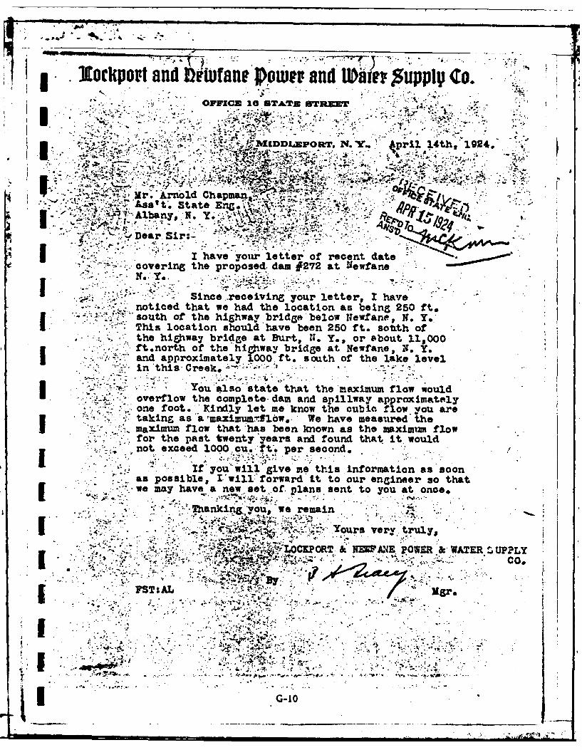
lructpoI and1 rwane ~Omer and Wi up CooSOFFICE 16 STATE STREE .. ",
Api 14h 19, 4
4'~~Mr. Arnfold Chapman j'-"
-z ..
**
* I have your letter of recent datezcovering the proposed.. dam IF272 at Newfane
I. 7Since receiving your letter, I havenoticed that we had the location as being 250 ft.so uth of the highway bridge below Newf ane,. N. Y,I - This location should have been 250 ft. sotith ofthe highway bridge at Brurt, 11. Y., or about 11,000
* ft~north of the highway bridge at Newfane, X. Y,3 and approximately 1000; ft. south of the lake levelin 'this -Creek, ~'- ~- . .
You ailso "state that the maximum flow wouldI overflow the complete-dam and spillway approximatelyone foot. 'Kindly let me know the cubic flow. you aretaking as "a mazimumf1jbw&. We have measured theI maximum flow that'has been known as the maxium flowfor the past twenty'years and found that It would,not exceed 1000 cu.'ft'. per second.
.-2o~ii"Sv meti nomto.sso
as possible, I'will:'forward'it to our engineer so that
if emay have anew se~fpassent toyou at onceo
n';.; .. ours very~tuyKP NESANE. OWER & _
FSTsAL .. "Mgr.
:.2
G-1

A
IL -L tIT -5X &.*
r..T)Z4 0 ..t ,.1 1".. , , ' " ,t
k4 0 r raeaia4_ 0~oIeC... ,r J ~ gaN~~8 '~~~
0*4N
- .:Applicatio forth Cnuto ir, Rconstruction of a Dam:.I 'iSatb-ni~erbymade to fth StattE-tngG . A . . in oipliance, with the provisions of Chapte
* LW ltctthe CO siad ti m an' d Chapter 6471o' 2gu Section 22 'a2 aMened for the apprOVal Of specift-
I hereitIh-mahmitted for te.. .d= locted :as stated'below.Il pwtAuu~o la.ilbcm iewitL n the erection of the Lrp.ddrn . -
the town
I A.,Z~~i~ Q . i ... ~ ?, ,1 .-
2. 3* Th am~r an drus of the owner i.olp~tR XMZA"^~ Pwne &_gt3 ~ ~ ~ ~ ~ ~ ~ ~ ~ ~~~t~ .. N'..'r r:b~~i.2- .~i~~~,~KdIMopozt NY.i-. The dam= will be used Xo.~l±onfa~~c.ae £~L~
4. Wilany part of the darnbe built pa oritjon4foda ~tate Ls 6 11 s. .The.watqrshed at'th proposed dam draining into the pond to be formed thereby i-- 8St.. . *,-.: - .. , .:: . , .. t* -! ~ ~
The ropsed da ill hae a pond ame a pilreat elevation of 'L2.' cr- n wLill impound 1'72L O n CO fe o atr
1.Telowest part of the natural shae ft epond' Is fvert diqfy abov th illcrut,Iand eOwwhr ls h shore will he at las 20A '___ fdAbove th. spilauL.-.
L. The maxi mum known Bow of the sbum at fte da Sate .i2A bhfeet per seond on......* . stimate, norcrd .
g~ ~ Aj ems =W~tay ig o ieoxt n ,*dnu, ed r othe proprt could be casdby any possible
hbve (4aC avl. pin~~wulrn~uhic04 4 sn;n, oldu
M W p a a *ae r , t h b e d * a ip i * *t e o k l r % S c n
G-lVam~ ~ :. .: 4

-.i.The material of the right bank inthe d Oft with the current, 1:[@ tone; at th splcri "I"
1%% UMa this materialbas hoiona ton thoe cete &AU~ tof thes.s ~ h~ daun.a
ft Ibicac.at this elevtion ____n h o uaeetnsfra9etclhht 3 0 &gzs
V14 . 99%, '!' ,- '', .. 2-1
,nnsThj material othlet 0ank hasi*ZO a top' slope- aL.La e -to a ot hoiatZl'V
!Mand a hih~L&.de:,Stateo the1 in. to thehadesp snawtebngscctthrcteoh e and. tha ifirsp
9i. - - ..
~~9T11 INt 9 .
44,,
will4 Y Ileghtb I -j19. If. 9*9* b i h
e~f~z -&=inohavloe ra tp widter~o..,t d;ad' a the- efw etd by foot horizontalto
the sea=-.^"* 1W ~.*99*
~~~WA=* Th:. Te wl e aso f loo ishre 'ie.......m dia5eter and the otm le..e.....rs
fetbe hao thelet ans&c rgt4Afe iei the clea by ic t*.eeA J hah ndteboethel
at5 e4.fe belowA-fttbv the spiflorest have a~ to'it
t-M The ill belo the proosd dam her willb narnbil L cnrt
ISKJC~ fet lo~.4S~etwid andLatJet.tik The downstream side of the arnwill, have a thickms
* c...etfor a width O 2.Jt;-e'DtI:on D)wg 3.332'J.39o..~-
-so.A PeAM. Each aIctofoa uiofadr ersftinhgti b accotopansed by aL location
=9na andcomplete woriking drawig of the proposed structure. Each drawing should have a title giigthepat
ab~~!own, the nam of the town and b th do iei lctdad h u f h we wdo
-X: MW loato na L.S OUW o other map) should show the exact'location of the propoeed
dem%~ buildings below the damn which might be damaxged by any faiure of the damn; of rostds 4acent to cc hvsmng .
i" Cth swm blowthedam, giving the lowest elevation of the roadway above the stream bed and giving the "Mhape,'
449C~~~h~~ajthewidtdtk ~~~~7 ofuemoe;g;adr n maljmt r te lpsta nyfotcl erv
~,.~.-i~# .p *. - .G'-129 -'9. 9

The complate working giveced anf the Z W2 Z2ion -etemauaios"o hes! and all theadf blwkehm!lTeeaye tcedote
any e Vports, calclatons itivestigations oropinions ta a i nsoigtedf n
~omniimora~srutre, fplan have not been m@4s on thoeij ct~!L sket& tosiealm; at the highest point;- showing tbheih.te
of~te~~n. rfernceto te silcrest. the~e ezh of tescin n h~~ matida of which the section is to' be. AMAcq. secto.wt aaiultw uosec apa r.
Sshow. the above sections by their top lines;.giving ttw mArk and the ent of each; h by e openmginbthefrhorta(., ....-- .
d;-4sio--*AVAthebutments bytheir top width and top. lengths from the upstresm fage of the splulrut andve.
' - -,
,.d-,-- the deaio fthe topi refenc to the spi--cm-.
u.B=uva1zoma Also. give the eetions, if possible hi the Mea= Sea revel, of at least two pemanet Bench
Kaft ofthmspillrest for any existing dam on the proposed dam site, at the -Ml and at both ends of the spill;
m~estfortafo te aovropoeda.~ ~U-pzx Whns-ntrce;
s~. amas Whe soinstructed, snsals ofthe -aterials to, be used i the construction of the proposed
rr damn using shipping tap whic will bo fish._% :o sn one-hl ui oti dsrd o eet three insand feethe naturalbed tuztcubicnches -- - --
* - . .ROL
_24- hmmx.-StAbw inpcis to lie pmovided for oigconstruion~I'- npcin by a. Pz'ofessionar'Enineee licensed in the State o f New York*"
25 A WAMM SUMPL. Aet.wtr mo'e by the above damn &o' be use& for a public, water. sipplyP . .Ha an applicationunz~er the provisions of Article* X"o itie'8Fn~srtion Law for suchuse. bee d tolthe Water: Control, Commiss0.nj Albany, X. 7 ?
aA-
'4.~V $ io *L q
4.~~ .1j..~~ - ., - ..%4Aa4f ;.
-Y4 *i.P 1 %\ ^V -t4 -
-* miVA am 7. 7 **
44

- ~s%.. 77-
.,~ .. ) . ~ 1 4W~~za~'e a(L!.i . ~L.! *A
4~,r a *'&.-**. .~ L *Ii L~ri~ C7 .1
'"C-,,.
V44SO~l s~okd er he mttoz'of temiu tox of-.
by, - som ofthe; plant~ offjcIa.jj; Lao port who. have bad. ezorence-* Iwitthiitswea~tr'~~h~ iqaz', hat 8030 CP ha een. considered.h -7*
to .- ~ :lood n)* ~ ol:ocI. ths.. pautt is, yeaaa i ; LdI te- '4errC eer rs.6Z4.ibm" aftboe Tijo&Sn -was, bn.' th tth -in er M;u
showirthe1nd wich i4llbe!'tlooded, If.- 1000, CPS- Is -ptdown-ti*,MUXW-UU '-kt07i* tios'that O'er" have obtalned,,-
4rek -' oX.sd atchs~en., .
imes..Jik b .*,."sj o ln. . - ha.befHode it. thee ~, *.'
The spillway i ,proposied.1I. ompplo *.to.' take. care. of. more .than 1000 CP'S* k ith lieh tuz'bvh6 gkieF6lo d "and "in addition to'that, thees is.5the, sluice gqAte w#c#h can-also. be, used. . It.%must'-be kept !4 ~z~87that pv6ticaily an. of th~q water coming down this Creek is12 -*Idischarged from the Canal and that the streAm- 1s short" %the dreAnamethere In: small snd 1I I relatively not subject. to floods to, anythIng
likerth~~*te~eta a tresm'dold be- 1Tits entire volIdmewTam
-See' Colume I page 227 of Report of Now York" State Twnearid *
.3urvePyor-(1929)' on *Survey of rhi~hteen. Mile. Creek .- notema.; .
nnb-' ~ M.1 .1 10r! ., _
**we qb a ~ .*
' Tbs Amov bifnmacb ON a Gote b"a al my
-SX
4 .
.--14

I ATE
ILMEI