Embed Size (px)
Citation preview
10/03/2011
Assimilation of GlobSnowData in HIRLAM
Suleiman Mostamandy Kalle EerolaLaura RontuKatya Kourzeneva

Contents
• Introduction
• Snow from satellites
• Globsnow
• Other satellites
• The current study
• Experiment design
• Preliminary results
• Concluding remarks and plans
• SNAPS
28.01.11 2
Why snow
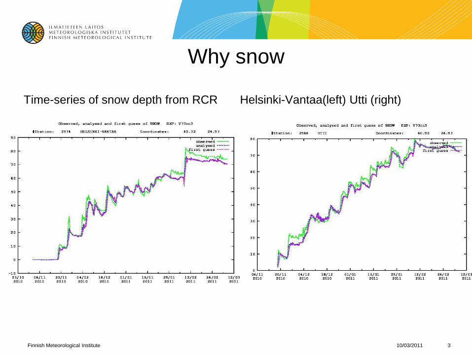
Time-series of snow depth from RCR Helsinki-Vantaa(left) Utti (right)
10/03/2011Finnish Meteorological Institute 3

Snow analysis is by no means a trivial task!
Snow edge is difficult to analyze
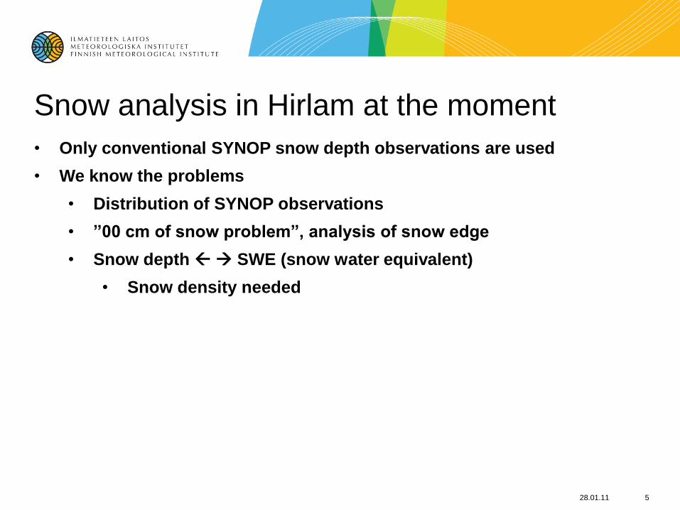
Snow analysis in Hirlam at the moment
• Only conventional SYNOP snow depth observations are used
• We know the problems
• Distribution of SYNOP observations
• ”00 cm of snow problem”, analysis of snow edge
• Snow depth SWE (snow water equivalent)
• Snow density needed
28.01.11 5

Snow from satellites
• Globsnow
• Other satellites
10/03/2011Finnish Meteorological Institute 6
ESA GlobSnow (2008 –2011)
10/03/2011Finnish Meteorological Institute 7
•Production of new global snow extent (SE) and snow water equivalent (SWE)
climate data records, with a demonstration of a near-real-time processing
capability.
•Consortium led by the Finnish Meteorological Institute (FMI) with
collaborators: ENVEO IT (Austria), GAMMA Remote Sensing (Switzerland),
Norwegian Computing Center (NR), Finnish Environment Institute (SYKE),
Environment Canada and Norut (Norway).
•Project details including technical reports and newsletters available at
globsnow.fmi.fi. or www.globsnow.info

10/03/2011Finnish Meteorological Institute 8
30 year ECV/FCDR time-series on snow conditions
of Northern Hemisphere (ESA-GlobSnow – led by FMI)
• Spaceborne passive microwaveradiometer data combined withground-based synop observations
• 25km spatial resolution
• Uncertainty for each grid cell
• Temporal coverage 1979-2010
• Demonstration of NRT (near-real-time) service on-going
• www.globsnow.info
• Reference: Pulliainen J. 2006. Mapping of snow water equivalent and snow depth in boreal and sub-arctic zones by assimilating space-borne microwave radiometer data and ground-based observations. Remote Sensing of Environment, Vol. 101, pp 257-269.)

Main features for SWE:
• The snow water equivalent product will be based on the combination of satellite-based microwave radiometer and ground-based weather station data (Synop-observations).
• The long term SWE data set will span the years 1978 – 2010
• The snow cover maps are produced as daily, weekly and monthly composites
• Nimbus-7 SMMR, DMSP SSM/I and Aqua AMSR-E are the main data sources, SSM/I for 1987 - 2002, AMSR-E for 2002-2010
• Non-mountainous areas of Northern Hemisphere are covered
• The SWE maps will be generated using in a 25km spatial resolution
• Demonstration of an operational near-real time SWE mapping service was initiated on October 2010
10/03/2011Finnish Meteorological Institute 9

Main features for SE:
• The long term SE data set will be generated for the years 1995 – 2010
• The snow cover maps are produced as daily, weekly and monthly composites
• ESA ERS-2 ATSR-2 and Envisat AATSR data are the main employed data sources
• Areas with seasonal snow cover on both Northern and Southern Hemispheres are covered
• The SE maps will be generate in a 0.01 degree (approx. 1km) spatial resolution
• Demonstration of an operational near-real time SE mapping service will be conducted out at a later stage of the project
10/03/2011Finnish Meteorological Institute 10

More details important for us• Normally the data of previous day is ready around midnight
• If conflict with satellite and Synop information, more weight to Synop
• In autumn and early winter the quality is worse (snow appearing and disappearing)
• SE and SWE are based on different instrument, clouds problem to SE
• In the future SE and SWE are combined
• Development this year and operational already perhaps next year
• Globsnow Newsletter published 3-4 times a year
• SWE on ”mountains” not very good (”mountains” based on slopes, plateau is not ”mountain”)
• In longer perspective FMI GlobSnow (non-mountainous) and Turkish data (over mountains) will be combined in HydroSAF project, but it is possible to use only the no-mountains data (mask)
• The file with coordinates will be created as an ascii file for easier use
10/03/2011Finnish Meteorological Institute 11

Most recent Globsnow map (20110309)
10/03/2011Finnish Meteorological Institute 12

10/03/2011Finnish Meteorological Institute 13
GlobSnow SE - Northern Hemisphere (monthly)
March 2003
February 2003
January 2003January 2003

10/03/2011Finnish Meteorological Institute 14
Optical SE – Iceland (AATSR monthly -> MODIS?)
March 2003
February 2003
January 2003

Other satellite data
• LandSaf file for the previous day are available about 3 am via Eumetcast, one product per day
• Comparison of IMN and LandSAF: an accepted paper by Niilo Siljamo and Otto Hyvärinen. Kalle has a copy of it (pdf)
• In IMN the priority in manual checking is in North America sometimes European side is not checked
• LandSAF is more fresh data, INM can contain older information
• LandSAF has only binary data (snow – no snow – unclassified) while GlobSnow has the fractional snow cover (percentage), to produce them GlobCover physiographydatabase is used
• LansSAF data is better in Central Europe (angle of the geostationary satellite), but similar product from polar orbiting satellite is coming (next year?)
• Resolution in Central Europe ~ 5 km
• SYKE (Finnish Environmental Administration) data
• only available on the Baltic Sea area and only melting period
• Same algorithm as in HydroSAF data , MODIS data
• not very useful for us10/03/2011Finnish Meteorological Institute 15

The current studyUse of satellite data in HIRLAM data assimilation
• Globsnow (to improve data coverage)
• Downloading GlobSnow SWE data from FTP/HTTP server (http://www.globsnow.info)
• Converting data from HDF to ASCII (specob format)
• Converting SWE to snow depth using constant snow density, as done while producing Globsnow data
Using the HIRLAM 7.3 with new surface scheme• More sensitive to snow analysis than the old scheme
Three experiments were run:
1. Reference: only synop
2. The Globsnow and Synop observations are included
3. Only Globsnow without Synop observation
No independent snow observations to verify against
• Differences in the analysis
• Changes in the forecast (t2m etc.)
• Verify the forecasts28.01.11 16

Design of the experiments
• Hirlam version
• Latest 7.3 version
• New surface scheme (”newsnow”)
• Resolution 0.15 deg., 60 levels
• 3DVAR
• Time
• 15.Oct – 24.Dec 2009
• 15. Mar – 15. Apr (30 Mar) 2010
• Globsnow observations
• Use them when available, some days with missing Globsnow file
• If exist, use the same file for every cycle of the day
• for winter 2010 -2011 they are available near real time
28.01.11 17

Different data scenarios
• Reference: only SYNOP observations
• Globsnow data in addition to the reference
• Globsnow data without SYNOP data
• Globsnow data using HIRLAM orography
• Original resolution of the Globsnow data: ~25km
• In the current study thinning of data to 75 km done (technical aspect)
28.01.11 18

Preliminary results
• The analysis of the results has just started only first impressions and findings can be shown
• Results only for the autumn/early winter 2009 (more problematic season)
10/03/2011Finnish Meteorological Institute 19

10/03/2011Finnish Meteorological Institute 20

Blue: 0.01 … 1
Light blue: 1 … 3
Green: 3 .. 5
Orange: 5 .. 10
Red: > 10
10/03/2011Finnish Meteorological Institute 21

Compare of Synop and Globsnow data
10/03/2011Finnish Meteorological Institute 22
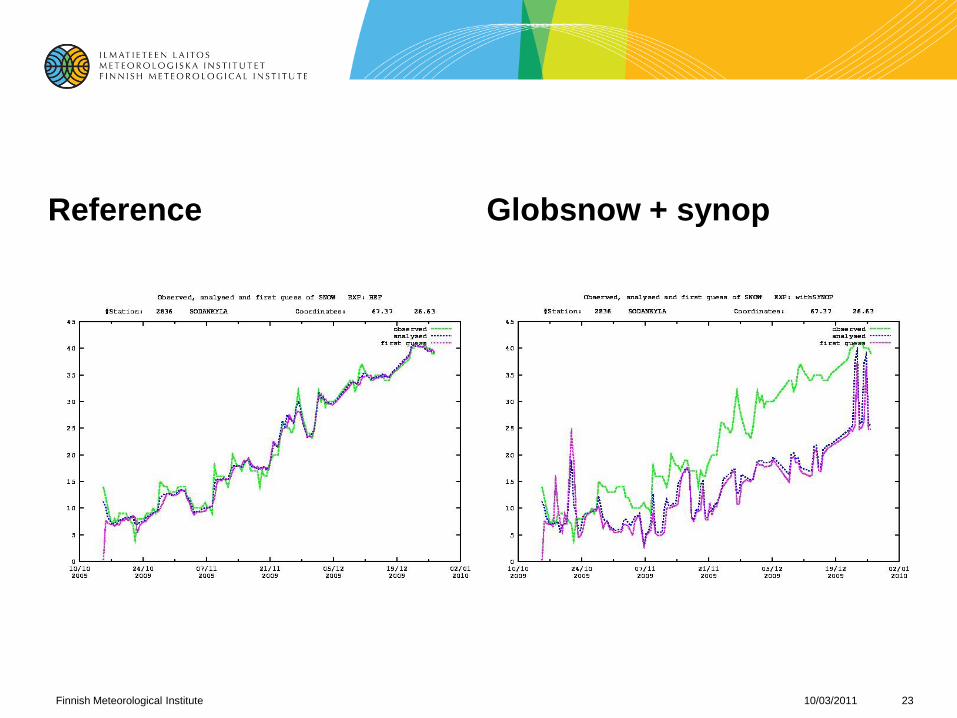
Reference Globsnow + synop
10/03/2011Finnish Meteorological Institute 23

10/03/2011Finnish Meteorological Institute 24

Preliminary conclusions and plans
• Technically the system is working: data from Globsnow to Span
• The autumn experiment has been preliminary examined
• The snow extent is reasonable in Globsnow
• Underestimating the snow depth in some areas
• Conversion from SWE to depth?
• Problems in Globsnow data in autumn?
• Peaks in analysis when Globsnow data missing
• analyse directly SWE, convert Synop to SWE
• Problem in data quality check close to eastern boundary
• So thinning of data to 25 km should be tried
• More careful analysis of autumn period and analysis of spring period
• Can other data (IMN) be used for verification?
• Use of same Globsnow data in all daily cycles: should it be used only once?
10/03/2011Finnish Meteorological Institute 25
26
FMI expertise in snow mapping
- contribution to SNAPS
Kari Luojus, Jouni Pulliainen, Petteri Ahonen, Riika Autio
10/03/2011Finnish Meteorological Institute 27
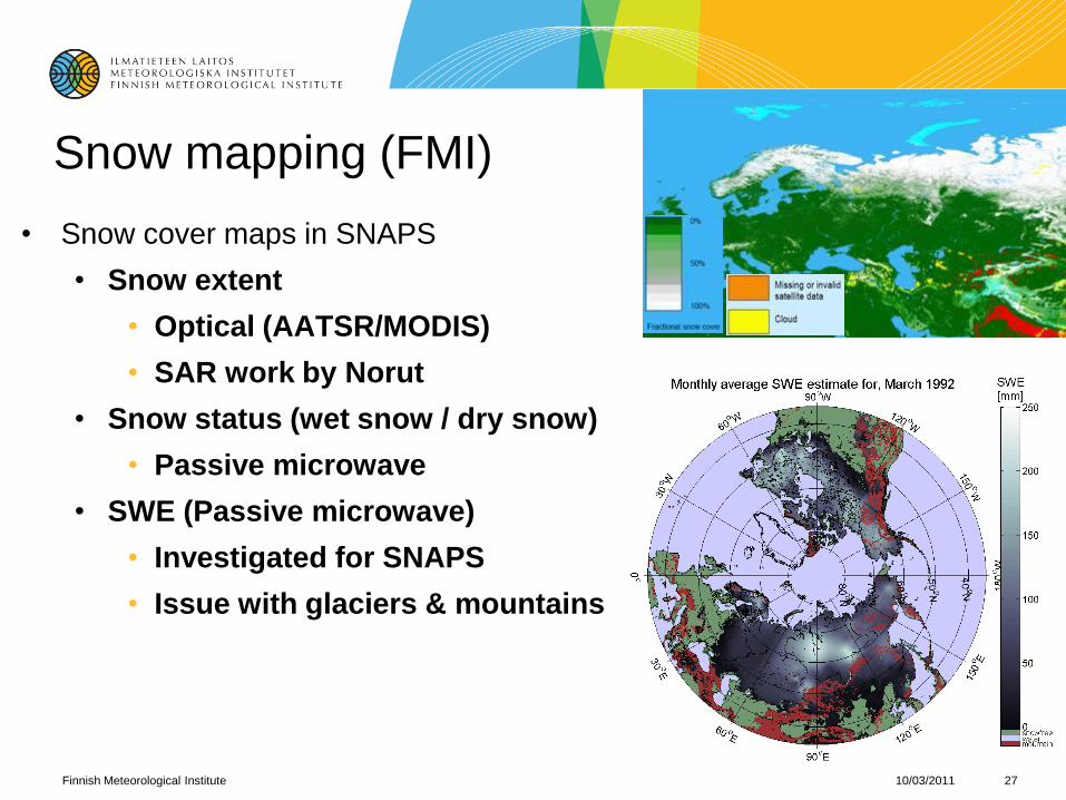
Snow mapping (FMI)
• Snow cover maps in SNAPS
• Snow extent
• Optical (AATSR/MODIS)
• SAR work by Norut
• Snow status (wet snow / dry snow)
• Passive microwave
• SWE (Passive microwave)
• Investigated for SNAPS
• Issue with glaciers & mountains

10/03/2011Finnish Meteorological Institute 28
FMI objectives in SNAPS
• Snow cover maps
• Near-real time snow cover maps updated shortly after satellite data has been received
• Snowdrift forecasts
• Pilot system based on visibility sensors compared to radar data
• Special case road snowdrift, observed from pilot road weather station
• History of snow cover
• FMI data archives exploited, special case Sodankylä dense data
• Avalanche forecasts for specific areas.
• Supporting role, as avalanches not occurring in Finland

29
HIRLAM and HARMONIE
- possible FMI contribution to
SNAPS snow mapping
Laura Rontu, Kalle Eerola,
Suleiman Mostamandy, Ekaterina Kurzeneva
Richard Essery (University of Edinburgh)
30
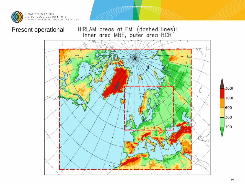
Present operational

HIRLAM = High Resolution Limited Area Model
- Operational NWP in 9 European countries- Used for research over any domain over the globe- Contains atmospheric and surface data assimilationand weather forecast model, including snow assimilation and parametrizations
- Maintained and developed by the international HIRLAM programme http://hirlam.org
- Close cooperation with the international ALADIN programme > HARMONIE NWP framework
We suggest for SNAPS
To provide SNAPS withkilometer-scale gridded snow depth/water equivalent maps based on HIRLAM/HARMONIE data assimilation
To provide dedicated stand-alone snow data-assimilationsystem (by the Edinburgh university) withatmospheric forcing data including temperature, humidity,wind, snowfall, downwelling radiation fluxes
To obtain this, we suggest to

33
To set up two NWP experiment domains with a 2.5 km horizontal resolution: Iceland and North of Scandinavia
To perform data-assimilation + forecast experimentsover these domains during agreed test periods with assimilation of- conventional SYNOP observations on snow depth,- satellite snow water equivalent from Globsnow - available local snow depth/density measurements
To work in cooperation with the partners inIcelandic Meteorological Office andEuropean Space Agency projects Globsnow, CoSDAS and North Hydrology
10/03/2011
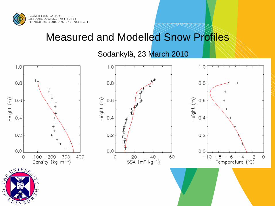
Measured and Modelled Snow Profiles
Sodankylä, 23 March 2010
10/03/2011Finnish Meteorological Institute 35
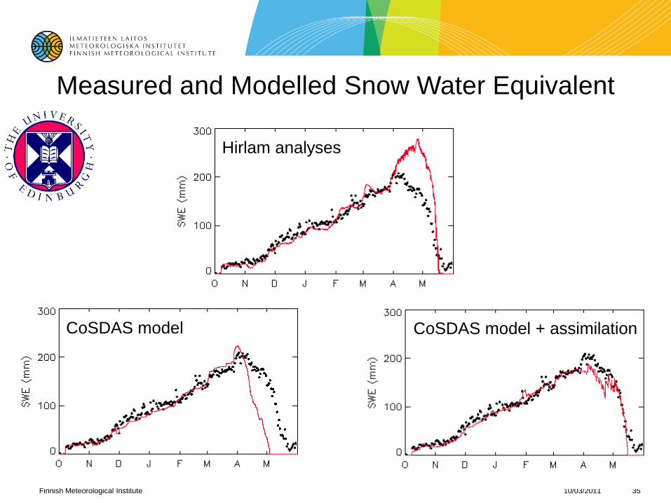
Measured and Modelled Snow Water Equivalent
Hirlam analyses
CoSDAS model CoSDAS model + assimilation