Embed Size (px)
Citation preview

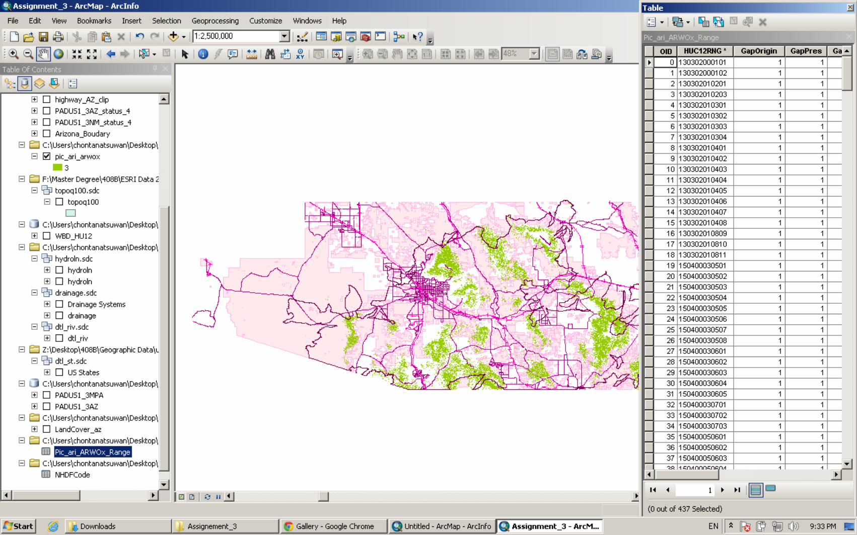
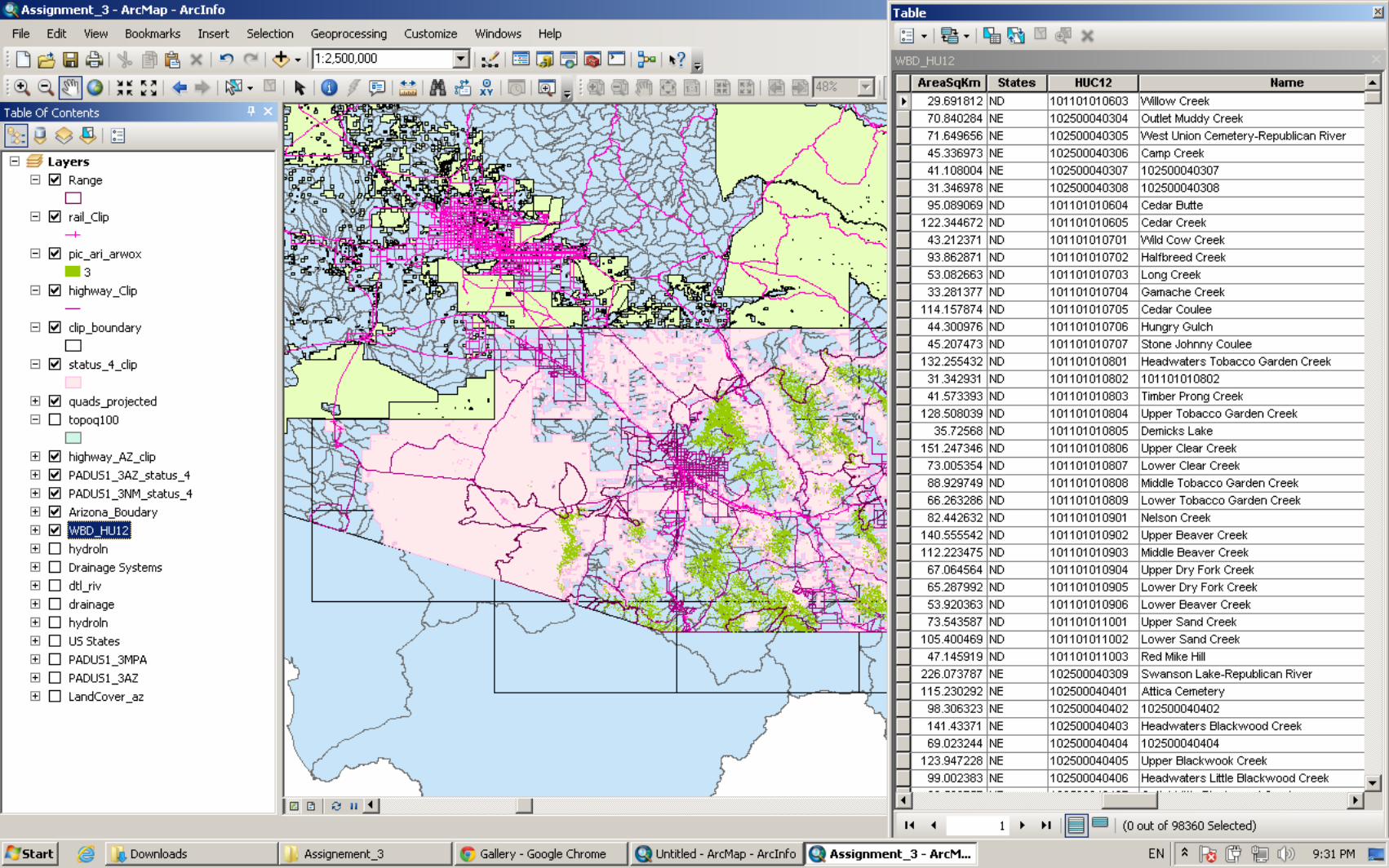
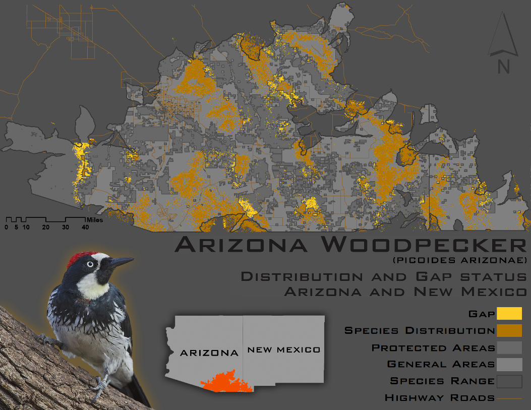
! “A#Gap#Analysis#consists#of#mapping#three#data#layers#—#land#cover,#predicted#distributions#of#vertebrate#species,#and#a#stewardship#layer.#This#data#is#then#assessed#to#determine#how#much#of#a#target#species’#(plant#or#animal)#habitat#is#in#conserved#areas.#From#this#assessment,#planning#decisions#can#be#made#about#whether#further#protection#is#merited.”!As!the!statement!said,!the!question!of!this!research!are!how!much!species,!Arizona!Woodpecker,!would!be!conserved!in!the!protected!areas!and!what!kinds!of!land!covers!are!Arizona!Woodpecker’s!habitats!by!overlapping!two!data.! The!mapping!process!started!with!acquiring!and!preparing!the!data.!In!this!analysis,!species!data!and!modeling!were!Airstly!chosen!to!assess!possible!area!that!existed!in!online!databases!and!local!hard!disks.!Land!cover,!the!second!needed!data,!was!downloaded!then!followed!by!Protected!Areas!data.!Two!Protected!Areas!data!of!two!states!were!used.!Moreover,!Hydrologic!Unit!Codes!data!(HUCs)!with!12!digits,!Drainage!data,!Transportations!data,!Topoquads!data!and!State!Boundaries!data!were!downloaded!and!used!as!additional!data.!Afterward,!all!data!were!imported!to!ArcMap!to!minimize!unwanted!data,!to!reduce!size!of!data.!Additionally,!the!selected!areas!were!chosen!by!using!state!boundaries!in!the!Airst!step!and!then!using!topoquads!to!create!a!clip!boundary.!Some!attributes!of!the!data!were!queried!and/or!selected!for!specifying!areas!by!joining!with!other!tables!in!order!to!scope!a!possible!data.!HUCs!and!Species!Range!were!combined!by!joining!12!digits’!Aield;!Protected!Areas’!table!was!queried!and!acquired!merely!Status!4!(There!are!no!known!public!or!private!institutional!mandates!or!legally!recognized!easements!or!deed!restrictions!held!by!the!managing!entity!to!prevent!conversion!of!natural!habitat!types!to!anthropogenic!habitat!types).!! After!obtaining!prepared!data,!dissolve!Species!Range!using!Dissolve!Tool!to!combine!into!a!single!shape!since!needing!an!edge!of!species!range!including!species!distributions.!Due!to!two!Protected!Areas!(Arizona!and!New!Mexico)!are!needed,!Merge!Tool!merged!them!to!a!single!layer.!To!answer!how!many!species,!Arizona!Woodpecker,!would!be!conserved!in!the!protected!areas,!the!tool!namely!Extraction!by!mask!was!selected.!This!tool!could!extract!species!that!are!looked!alike!a!surface!of!protected!areas!and!cut!off!unWrelevant!data!on!target!areas,!whereas!other!tools!could!not.! The!consequences!of!this!analysis!are!Species!Distribution,!which!is!in!a!Protected!Areas!found!apart!in!Protected!Areas!sporadically.!The!massive!area!is!the!biggest!protected!area.!Mostly,!Arizona!Woodpecker!can!be!found!nearby!forest!or!woodland!areas.!Some!of!them!can!be!found!nearby!temperate!Alooded!and!swamp!
Assignment)3):)Conducting)a)Gap)Analysis
forest!areas.!However,!the!species!is!rarely!found!along!the!highways!and!railroads!or!even!in!the!urban!areas!located!in!or!nearby!the!protected!areas.!Arizona!Woodpecker!can!be!found!in!New!Mexico!State,!as!well.!From!the!graphics!assessment,!it!was!found!that!likely!less!than!30%!of!all!Species!Distribution!has!been!conserved.! To!sum!up,!this!analysis!revealed!that!Arizona!Woodpecker!has!not!been!conserved!as!well!as!it!has!to!be.!It!might!be!due!to!the!fact!that!most!of!them!have!their!habitats!out!of!the!protected!areas.!In!my!point!of!view,!expansion!of!more!conserved!areas!and!limiting!the!expansion!of!urban!areas!would!yield!high!percentage!of!the!conserved!species.
!
Assignment)3):)Conducting)a)Gap)Analysis