Embed Size (px)
Citation preview

ASSESSMENT REPORT ON
DIAMOND DRILLING, GEOCHEMICAL & GEOLOGICAL WORK ON THE FOLLOWING CLAIMS
TR 4 . . . . . 4960(91 (9) (9)
TR 5 . . . . . 4961 TR 8 . . . . . 4964
PART OF THE TR #l GROUP
located
80 KM NORTH-NORTHWEST OF STEWART, BRITISH COLUMBIA
SKEENA MINING DIVISION
56 degrees 35 minutes latitude 130 degrees 09 minutes longitude
N.T.S. 104B/9E
PROJECT PERIOD: Aug. 16 - Sept. 29, 1987
ON BEHALF OF TEUTON RESOURCES CORP.
VANCOUVER, B.C. ': 5~ :r, *r ; '5' 5 3
i ij::; ;; 1987
I
REPORT BY
D. Cremonese. P. Eng. 200-675 W. Hastings
Vancouver, B.C.
Date: Dec. 28, 1987
1
TABLE OF CONTENTS
1. INTRODUCTION
A. Property, Location, Access and Phys;ography B. Status of Property C. History D. References E. Summary of Work Done
2. TECHNICAL DATA AND INTERPRETATION
A. B. C.
D.
E.
Regional Geology Property Geology/Mineralogy Geochemistry
a. Introduction b. Rock Geochem Samples c. Silt Geochem Samples
Diamond Drilling a. Introduction b. Core Geochemistry
Conclusions
APPENDICES
I Work Cost Statement II Certificate
III Assay Certificates IV Drill Logs
ILLUSTRATIONS
Fig. 1 Location Map Fig. 2 Claims Map
Map No. 1 Geochem Sample Locations (TR 4, 5 and 8 claims)
Map No. 2 Rock and Silt Geochemistry: Au (ppbl and Ag (ppml values (TR 4. 5 and 8 claims)
Map No. 3 Konkin Gold Zone (Showing Sur- face sample, trench and drill hole locations; Au/Ag values; rock types) (TR 4, 5 and 8 claims)
Page
2
2 2
12 12 13
Report Body Report Body
Map Pocket
Map Pocket
Map Pocket
1. INTRODUCTION
A. Property, Location, Access and Physiography
The property is located about 80 km north-northwest of Stewart, British Columbia. Nearest road is the Cassiar-Stewart Highway about 17 km to the east. Access is presently limited to helicopter, either from the base at Stewart or at Bob Quinn Lake (during the 1987 program helicopter service was provided by Vancouver Island Helicopters directly from the Catear Resources' base camp about 1 km north of Brucejack Lake. The recent completion of a temporary road from a barge terminal on Boaser Lake into the Sulphurets gold-silver prospect near Brucejack Lake has provided yet another alternative means of access
The claims cover an area of rugged, mountainous terrain at the head of the Treaty Creek Glacier. Elevations vary from approximately 1350m to 2000m. Vegetation in the area is limited to low-lying shrubs, mountain grasses and heather.
The best rock exposure occurs where glacial retreat has been most pronounced. These exposures are interspersed with areas covered by glacial debris and moraine. Although slopes are steep, well over half of the exposed areas can be accessed by foot without the help of mountaineering equipment.
Climate is severe, particularly at higher elevations. Heavy snowfalls in winter and rain in the .short summer working season are typical of the Stewart area. Inclement weather conditions and reliance on helicopter transport make this a high cost area to explore for minerals.
B. Status of Property
Relevant claim information is summarized below:
Name Record No. No. of Units Anniversary Date
TR 4 4960(9) 18 Sept. 30, 1987 TR 5 4961(9) 20 Sept. 30, 1987 TR 8 4964(g) 8 Sept. 30, 1987
Claim locations are shown on Fig. 2 after government N.T.S. map 104B/9E. The claims are owned by Teuton Resources Corp. of Vancouver, British Columbia.
C. History
Two, brief isolated accounts in the B.C. Department of Mines Annual Reports mention that the Consolidated Mining and Smelting


3
Company of Canada Ltd. (now Cominco) explored a large mineralized zone, parts of which are now covered by the TR 5 claim, during 1929 and 1930. Although Consolidated located 57 surveyed Crown-grant mineral claims in the area, exploration ended abruptly in 1931 and the claims were abandoned. Results of their exploration efforts were not published.
It is also reported that several prospecting syndicates explored the general Treaty Creek area during the 1950'S (Ref. 1). In 1953, prospectors Charles Knipple and Tim Williams reported a small silver sulfide vein south of the Treaty Claim. Large boulders of tetrahedrite were also reported on the ice surface (source remains unlocated). Further work in 1967 ostensibly located a significant magnetic anomaly at the junction of Treaty Creek and South Treaty Glaciers.
This, and further work in the area appears to have con- centrated on the highly visible alteration zones to the north and east of the TR 4, 5 & 8 claims (covered by other claims in the TR series). It appears that very little work, if any, has been carried out previously on the nunatak controlled by the TR 8 and TR 9 claims. Because this exposure lies on trend with the prolific gold-silver deposits now being explored at the Sulphur- ets property (just to the south), it became a priority target for investigation during the 1987 work program.
D. References
1.
2.
3.
4.
5.
6.
7.
GROVE, E.W., P.ENG., PH.D. (19831: Private Report for Teuton Resources Corp. on the Treaty Claim.
GROVE, E.W. (1982): Unuk River, Salmon River, Anyox Map Areas. Ministry of Energy, Mines and Petroleum Resources, B.C.
GROVE, E.W. (1971): Bulletin 58, Geology and Mineral Deposits of the Stewart Area. B.C.M.E.M.P.R.
ANNUAL REPORTS, MINISTER OF MINES, B.C.: 1929 -- p. c102; 1930 -- p. AllO.
BRITISH COLUMBIA MINER (19281: "Portland Canal Notes" by W.R. Hull, p. 36, December 1, 1928.
KRUCHKOWSKI, E.R. (19811: Geological Report Treaty Claim -- Bowser-Unuk Project, NTS 104B/9E, for E & B Explorations Ltd.
CREMONESE, P.ENG. (19841: Assessment Report on Prospecting Work on the Electrum 1 and Electrum 6 Claims, NTS 104B/9E, On File with the B.C.M.E.M.P.R.

4
8. CREHONESE, P.ENG. (1985): Assessment Report on Geological and Geochemical Work on the Treaty Claim, NTS 104B/9E. On File with the B.C.M.E.M.P.R.
9. CREMONESE. P.ENG. (Feb., 1987): Assessment Report on Geochemical Work on the Treaty h TR 2 claims, NTS 104B/9E, On File with the B.C.M.E.M.P.R.
E. Summary of Work Done.
In the first phase of exploration. a silt and rock geochemi- cal survey was conducted over the claims by E.R. Kruchkowski Consultants of Calgary, Alberta. Kruchkowski Consultants used the Catear Resources camp on the Gold Wedge Fraction (about 1 km north of Brucejack Lake) as a staging ground for reconnaissance exploration programs mounted for several resource companies in the area. Vancouver Island Helicopters also provided flight services directly from the Catear camp, a circumstance which cut costs considerably (in previous years, helicopter service was provided either directly from Stewart, or from the Granduc air strip).
A complete field camp complete with generator was mobilized by helicopter from the Catear base camp to a moraine flat in the southwest corner of the Treaty claim on Aug. 16, 1987. Crew consisted of four men, working daily in parties of two. Party leaders were Ken Konkin, geologist, and Gordon Sinden, geol.- technologist--two old hands in the Stewart area. Field super- vision was the responsibility of E.R. Kruchkowski, P.Geol. The author also visited the claims area to monitor progress.
Personnel and samples were demobilized by helicopter on Aug. 24, 1987.
Thirty-eight rock geochemical samples and 3 silt samples were collected during the survey. The silt samples and 36 of the rock samples were analysed for gold and silver by standard AA techniques; 2 of the rock samples were analysed for gold by AA and for 29 elements by I.C.P. (Inductively Coupled Argon Plasma). Certain of the geochemical traverses were assisted by helicopter drop-offs and pick-ups in order to maximize amount of ground coverable from a single field camp.
[Author's note: certain of the costs included in the Work Cost Statement (Appendix I) have been prorated because work on an adjacent group, the "TR #2 Group", proceeded at the same time. Based on an estimation of division of effort, 25% of these shared costs have been allocated to the claims forming the subject of this report (TR #1 Croup), 75% to those claims in the TR #2 Group.1

5
Extremely high gold aSSayS from the first phase samples quickly led to an expanded second phase of exploration spanning the period Sept. 7 to Sept. 29, 1987. This included minor rock geochemical sampling, blast trenching, helicopter pad construc- tion, drill pad construction, mobilization by helicopter of a diamond drill, ancillary equipment, camp and supplies, etc., and drilling of a hole 61.1 meters in length land sampling/analysis of drill core). The second phase was beset by difficulties: ex- tremely severe weather conditions confounded attempts to mobilize the drill and supplies; to make matters worse the under-powered drill rig supplied by the contractor could not handle the hard skarn formation encountered in Hole 87-l. As a result, costs were sharply higher than originally estimated.
Additional gold (AA) and 30 element I.C.P. assays were performed on 41 drill core samples and 9 rock geochemical samples.
Contractor for the drill program was D. W. Coates Enterpri- ses Ltd. of Delta, B.C. Geologist Ken Konkin of Kruchkowski Consultants monitored the drill program and logged and sampled the core.
2. TECHNICAL DATA AND INTERPRETATION
A. Regional Geology
The following capsule description of the geology in the Treaty Glacier vicinity has been excerpted from a private report (Ref. 1) by E.W. Grove. Ph.D., P.Eng.:
"The contact between thick Upper Jurassic Nass Formation sediments and the underlying Lower Jurassic Unuk River Formation volcanic assemblage lies along the toe of Treaty Creek Glacier and Treaty Creek. In this area the Nass Formation (old Bowser Assemblage1 comprises cyclically banded dark siltstone beds generally from 0.3 to 2 meters thick intercalated within grey- wacke beds one to six m thick which form up to 75 per cent of the north dipping, complexly folded sequence in this area. This sequence unconformably overlies middle Lower Jurassic thinly banded siltstones (east of South Treaty Glacier), volcanic conglomerates, volcanic bteccias, mixed chetty volcanic breccias, volcanic sandstones, andesitic flows, and minor rhyo-dacite flows. Thin siltstone and sandstone members intercalated within the dominantly epiclastic volcanic sequence provides evidence for the complexly folded nature of the country rocks in this area. Augite porphyry sills are found throughout this sequence and are well exposed along both flanks of the Treaty Creek Glacier.
All the country rocks in the area exhibit evidence of folding. The main feature in the Lower Jurassic sequence is a

6
northeasterly trending anticlinal warp. This is overlain unconformably by the tightly folded northeasterly dipping Upper Jurassic sedimentary sequence.
The country rocks in this area have been cut by numerous steep northeast trending faults which show left hand offsets of from several tens of meters to 150 meters, or right hand motion of a few tens of meters.
No major plutons have yet been uncovered in the area, but various small granitic to dioritic dikes cut across the Lower Jurassic sequence."
B. Property GeologyD4ineralogy
Rocks observed during traverses by the geochemical sampling crew on the northwest slopes overlooking the upper reaches of the Treaty Glacier (TR~8, 5 claims) include: weak to moderately altered, crystal-lithic andesite tuffs. intensely altered crystal-lithic andesite tuffs (sericite schist), dolomite, limestone, quartzite, pillow lavas, red, purple, green volcanic breccias and porphyritc flows (minor chert).
Coarse native gold was discovered in 1987 associated with extremely vuggy. oxidized (limonitic) quartz and calcite veining (pods?) within a skarned, silicified and dolomitic crystal-lith- ic tuff host: the "Konkin Gold Zone" (see Map No. 3). The auriferous quartz and calcite injection was accompanied by pyrite and chalcopyrite mineralization characterized by intense limon- ite, azurite and malachite oxidation.
The extremely vuggy gold zone is about 1.2 meters wide and has been traced for a little less than 3 meters on surface. A second zone of chalcopyrite-bearing. highly auriferous mineraliz- ation located 30 meters to the northeast may be a related feature. Further geological observations were rendered imposs- ible because of an earlier than expected snowfall which blanketed the ground by mid-September.
The near vertical quartz calcite vein system exposed in the gold pit (see Map No. 3) appears to plunge northerly into the steep glaciated valley wall. Because this structure was not inte~rsected in drill core, it is hypothesized that it may be cigar shaped (pod-like). The skarn assemblage in the vicinity of the gold pit consists of a silicified dolomite/lithic-crystal tuff host with magnetite, calcite, chlorite, diopside, chalcopy- rite, pyrite, specular hematite, epidote, trace sphalerite, malachite, azurite, and limonite.
Other mineralization encountered during the geochemical survey traverses includes sedex type pyrite seams, quartz veining
7
and quartz-sericite-pyrite alteration. Rough outlines of rock outcrops as observed in the field have been set out in Map No. 1. Locations are necessarily approximate and have been compiled from altimeter readings and notes/maps made in the field by reference to air photos.
C. Geochemistry
a. Introduction
Reconnaissance expeditions were undertaken daily during the first phase from a a well-equipped field camp located in the southwest corner of the Treaty claim. Individual parties of two investigated areas of interest on the TR 4, 5 and 8 claims. Access was directly by foot or by helicopter drop-off and pick-up. Rock and silt geochemical samples were taken to assess local mineral content.
Sample locations are shown in Map No. 1; gold values in ppb and silver values in ppm are shown in Map No. 2.
One of the first areas to be investigated, on the TR 8 claim, resulted in the discovery of an exposure of skarn-type mineralization. Subsequent receipt of assays showed extraordin- arily high values in gold. This area is now referred to as the "Xonkin Gold Zone" after its locater, geologist Ken Konkin. Relevant information is shown on Map; No. 3.
b. Rock Geochem Samples
An unusually high amount of the rock samples taken during the 1987 survey can be classed as anomalous based on a regional "rule-of-thumb" [by reference to similar reconnaissance surveys performed in the general area) that states values in excess of 200 ppb gold or 5 ppm silver merit additional investigation.
Sample values and sample descriptions are catalogued below according to somewhat loosely defined areas of interest.
b.l-Konkin Gold Zone
Samples XK 206-210, the "discovery samples", were taken by geologist Ken Konkin during the first day of fieldwork on the TR 8 claim. Sample notes are reproduced below:
KK 206 -4.76 m chip; skarn assemblage, 25-30% coarse grained, blebby masses of chalcopyrite, 15-20s masses of coarse grained pyrite, in silicified limestone.
Assay : gold-22,500 ppb silver-102.5 ppm
8
KK 207 --2.3 m chip; oxidized, massive pyrite (2D-25%), seams up to . 3m wide, limonitic skarn assemblage.
Assay : gold-6,700 ppb silver-17.2 ppm
Assay:
KK 208 --1.2 m chip; limestone, silicified skarn assemblage, 5-7% coarse grained pyrite.
gold-3,600 ppb silver-7.0 ppm
KK 209 --1.2 m extremely limonit
Assay: gold-3,600 ppb silver-4.4 ppm
KK 210 --1.2 m chip; oxidized zone, 80% limonite, 5% azurit malachite, 5% coarse grained pyrite and chalcopyrite, garnet .
chip; massive pyrite seams, 15-20 cm wide, ic.
Assay: gold-890,600 ppb silver-267.4 ppm Check fire assay: gold-30.092 ox/ton silver-S.62 ox/ton
e and trace
On Sept. 7, 1987, the author flew into the TR 8 claim with Ed Kruchkowski, P. Geol., to determine the source of the high values obtained in the samples noted above [Note: visible gold was not observed during the initial sampling by Ken Konkinl. Hand trenching of the XX-210 sample area unearthed several spectacular rock specimens containing abundant fine to coarse gold.
Further work, Sept. 9-10, 1987, resulted in an extension of the high-grade values in an area located approximately 30 meters to the northeast (see Map No. 3). Sample notes from geologist Ken Konkin's fieldbook follow:
KK-290 --1.8 m chip; dolomite skarn; 15-20% coarse-grained, disseminated pyrite, 5-10% disseminated coarse-grained chalcopy- rite, 7-10% calcite veinlet sweats.
Assay: gold-2590 ppb silver-8.6 ppm
KK-291 --1.2 m chip; dolomite skarn, sample centered on 45 cm wide massive pyrite seam; 3-5% chalcopyrite, minor malachite and azurlte, intensly limonitic and hematitic.
Assay: gold-77400 ppb silver-48.4 ppm
KK-292 --2.3 m chip; severely oxidized skarn. Same as KK-290
Assay: gold-3040 ppb silver-6.4 ppm
KK-293 --Same as KK-291; 1.0 m wide chip over 2.0 m zone (1.0 m

9
is covered by overburden and glacial moraine)
Assay: gold-3860 ppb silver-19.8 ppm
KK-294 --I.4 m chip; centered on massive pyrite seam; intense limonite oxidation; quartzitec?).
A blast trench was put in to open up the discovery area on Sept. 10, 1987. At the northern end of the trench, Ken Konkin took the following sample:
Assay: gold-36200 ppb silver-14.5 ppm
KK-295 --1.2 m chip in Gold Pit; 90% limonite, 10% quartz crystals; coarse-grained native gold, l-2% fine-grained pyrite; extremely vuggy.
Assay: gold-336400 ppb silver-120.7 ppm
b.2--Sericite Schist Zone
Samples IX-211 to KK-215 were taken from sericite schists exposed approximately 120 to 200 m northwest of the Konkin Gold Zone. Sample notes follow:
KK-211 --2.0 m chip; limonite oxidation; silicified, leached andesite tuff, 5-7% ghost pyrite, weak sericite schist
Assay: gold-23700 ppb silver+.8 ppm
KK-212 --2.0 m chip; same as KK-211
Assay: gold-3500 ppb silver-2.6 ppm
KK-213 --2.1 m chip; sericite schist, trace to 1% f ine-grained pyrite, 2-3% coarse-grained pyrite ghosts. Schistosity poorly developed.
Rssay: gold-224 ppb silver-O.4 ppm
KK-214 --0.9 m chip; same as KK-213
Assay: gold-1000 ppb silver-O.9 ppm
KK-215 --1.1 m chip; same as KK-213
Assay: gold-230 ppb silver-O.5 ppm
b.3--Dolomite Zones
The KK-216 to KK-227 series investigates two outcrops
10
featuring dolomite and minor quartzite/sandstone, located 250 m and 500 m northeast of the Konkin Gold Zone (see Map No. 3). Gold values range from 400 to 2400 ppb. Sample notes follow:
KK-216 --0.9 m chip; medium to dark grey dolomite. Sample centered on 223% disseminated blebs of chalcopyrite, 5-108 calcite veinlets Cl-3mm); 35-40% green chert
Assay: gold-700 ppb silver-Z.4 ppm
KK-217 --2.7 m chip; same as KK 216
Assay: gold-1000 ppb silver-3.0 ppm
KK-218 --grab; outcrop of severely sheared and crushed rock, jarositic, sericite schist; very fine-grained. disseminated pyrite, leached.
Assay: gold-2000 ppb silver-8.1 ppm
KK-219 --0.6 m chip; same as KK-218
Assay: gold-400 ppb silver-2.2 ppm
KK-220 --1.2 m chip; jarositic, leached, intense sericite alteration, blocky siliceous host; 2-3% fine-grained, dissemin- ated pyrite.
Assay: gold-700 ppb silver-2.4 ppm
KK-221 --1.2 m chip; same as KK-220
Assay: gold-500 ppb silver-l.1 ppm
KK-222 -- 1.2 m chip; centered on massive, coarse-grained pyrite pod dimensions lm by 2m: intensely sheared.
Assay : gold-640 ppb silver-3.8 ppm
KK-223 -- 1.4 m chip; from pyrite rich layer in quartzite. 5-10% disseminated coarse-grained pyrite plus minor 5% 3-5 cm wide pyrite seams.
Assay: gold-1600 ppb silver-3.2 ppm
KK-224 -- 1.5 m chip; massive decomposed coarse-grained pyrite
Assay: gold-2400 ppb silver-19.4 ppm
KK-225 --1.2 m chip; massive pyrite layers (60%) in dolomite (25-3-%I; quartz stockwork 110%) containing 3-5% galena. Quartz intrudes pyrite seam.
11
Assay: gold-1400 ppb silver-67.2 ppm
M-226 --Select grab; from quartz stockwork sample KK-225
Assay: gold-1980 ppb silver-113.9 ppm
KK-227 --1.2 m chip; sheared, siliceous dolomite; sample centered on 2-3s coarse-grained pyrite seam.
Assay: gold-600 ppb
b.4--Tetrahedrite Vein
silver--5.2 ppm
A small quartz vein mineralized with tetrahedrite, maximum width 0.3m, was discovered in the northeast corner of the TR 8 claim by Dan Aldrick, geologist with the B.C. Department of Mines. Two samples (grab?), DA 1 and DA 2, were analysed and returned, respectively: gold-6230 ppb, silver-355; gold-5675 ppb, silver 395.1 ppm. Samples taken from altered andesites in the vicinity, TR 91-93, did not register appreciable gold values.
b.5--Northern Section of TR 5 Claim
A number of reconnaissance rock geochem samples were also taken from the slopes overlooking the Treaty Glacier in the northern part of the TR 5 claim. Mineralized float boulders were located close to the ice in a lateral moraine. General trend of the boulders was estimated at 60 degrees azimuth. The boulders featured quartz-calcite veinlets in an argillitic host (possibly a brecciated vein) carrying 3-5 % galena and pyrite. Samples KK-232 to KK-234 showed gold values ranging from 104 to 420 ppb and silver values from 13.8 to 362.0 ppm.
Only one in-place rock geochem sample from this part of the survey showed anomalous values. Notes for Sample KK-230 follow:
KK-230 --1.1 m chip; sericite schist; excessive limonite, minor jarosite. No visible sulfides.
Assay: Gold-920 ppb Silver-O.3 ppm
c. Silt Geochemical Samples
Three silt geochemical samples were taken during the survey. Stream sediments were collected by sifting to minus 80 mesh in the field. The resulting fine silt was then carefully washed into a standard kraft bag and sent off for analysis by atomic absorption (sample size + 500 gm). These samples returned background values in gold and silver, only.

12
D. Diamond Drilling
a. Introduction
After viewing the Konkin Gold Zone on Sept. 7, 1987. E.R. Kruchkowski recommended that a series of short holes be drilled to test depth continuity of the Konkin Gold Zone. Shortly thereafter a contract was let with D. W. Coates Enter- prises; at that time their rig was in the process of finishing a large program on Catear Resources' Gold Wedge Fraction.
A three week spell of bad weather began shortly before scheduled mobilization. The rig and attendant equipment/supplies were transported at great expense by various helicopters into the Konkin Gold Zone drillsite. Costly weather-related delays plagued the mobilization and interfered with attempts to supply the drill program with replacement materials and parts.
It was then revealed that the drill rig, which had performed well enough on the sericite schists at the Gold Wedge Fraction, was not equal to the hard skarn at the Konkin Gold Zone. Drilling advanced very slowly and Was marked by an unusual consumption of materials because of caving in the hole. Due to bad ground conditions there was no circulation of water. Two storms during the period Sept. 23-29 almost led to a mutiny of the drill crew (camp was blown away by a heavy gust of wind]. Costs were approximately two to three times higher than expected.
Drill Hole 87-1 was completed on Sept. 29, 1987 reaching a depth of 61.1 m. A plan view of the drill hole is shown on Map No. 3. Bearing of the hole was 65 degrees, dip minus 46 degrees, elevation approximately 1530 m, s/*s - aq f&c)
[Note: Two further holes were drilled after the anniversary date of the claims, Sept. 30, 1987. For this reason, data on these holes and costs associated with these holes (including demobilization) have not been incorporated into this report.],
b. Core geochemistry
Drill core was flown out of the property and logged by geologist Ken Konkin in a warehouse in Stewart rented by Teuton Resources Corp. Extreme weather conditions and lack of permanent building facilities at the drillsite necessitated this move. [The core will be returned to the site in the 1987 field season after construction of a suitable shack in a location free from slides.1
The core was split in the warehouse yielding 41 samples averaging approximately 1.5 m of core per sample. These samples were shipped to Acme Analytical Laboratories and assayed for

13
gold values by routine atomic absorption methods. All of the core was sampled,
Rock type encountered from 1.8 meters (end of casing) to 61.1 meters (end of hole) can be classed generally as skarned volcanics. More specifically, rock observed in core consisted of weak to strongly skarned, silicified and dolomitic crystal-lithic tuffs. Skarn mineralization consisted of diopside. epidote, specular hematite, calcite, and chlorite; sulphide minerals predominantly pyrite with trace chalcopyrite. Minor quartz-cal- cite veinlets, vugs and limonite were in evidence along fracture planes and shears. More detailed information is contained in the drill logs appended to this report by K. Konkin of E.R. Ktuchkow- ski Consulting Ltd. (Appendix IVI.
Highest gold value obtained in the core was from sample #26227 representing the interval from 41.2m to 43.0m (1.8 m). This returned 1820 ppb gold or 0.053 oz/ton gold.
A review of the drill logs (see Appendix) and assay data shows a rough correlation between gold values and pyrite con- tent. It also appears that the massive, coarse-grained pyrite is associated with the higher gold values.
Because of the limited data set, it was not possible to define statistically threshold and anomalous levels for gold content. It is noteworthy, however, that 18 of the 41 samples (about 44%) returned values in excess of 200 ppb. Gold values above 200 ppb are generally considered anomalous in the Stewart region.
Significantly, the native gold-bearing, limonitic zone exposed on surface in the gold pit was not encountered by Hole 87-1, nor Was the abundant chalcopyrite (+ azurite/malachitel mineralization associated with it.
E. Conclusions
A routine rock/silt geochemical survey resulted in the discovery of a high-grade gold mineral occurrence on the TR 8 claim. Follow-up surface work isolated another highly auriferous occurrence about 30 m distant in a similar geological setting. Encouraging values, ranging from weakly to highly anomalous in gold, were also obtained in a suite of samples taken up to 600 m from the discovery point. An early snowfall unfortunately precluded a more comprehensive surface investigation in 1987.
Diamond drilling to test for a downward extension of the coarse gold-bearing mineralization exposed in the Gold Pit in the Konkin Gold Zone was unsuccessful in this regard. It is possible that this extension was intersected but not recovered in drill

14
c*re : critical sections of the core, particularly those parts containing massive sulfides (pyrite), showed very poor recovery-- as low as 10%. Another proposed explanation is that the gold pit mineralization has a cigar-like structure, making it tricky to intersect with only a few holes.
It is instructive to note however that the hole did encount- er substantial intervals containing anomalous gold values (above 200 ppbl. Since the surface high-grade showings appear to be bracketed by zones of lower-grade to anomalous values, it may be that the hole passed to one side of a hypothesized downward projection of the gold pit mineralization.
In any event, so little is known about this occurrence it seems premature to make elaborate conjectures. Much more surface work should be undertaken to determine limits and attitude of the auriferous zone(s). Surface trenching across the complete width of the known skarn exposures should be undertaken at regular intervals. This should also include removal of overburden in intervening areas. Detailed sampling and geological mapping, possibly with some bulk sampling of the high-grade zones, should follow.
Results from the reconnaissance geochemical program also suggest that the TR 5- TR 8 alteration zones may be similar to, or an extension of, the broad alteration zones characterized by unusually high background gold values on Newhawk-Granduc's Sulphurets gold-silver property, adjoining the TR#l Group to the south. Potential for large tonnage, lower grade bodies as well as low tonnage, high grade bodies is indicated. A rock geochem survey should be undertaken to cover outcrops exposed on the nunatak extending southwest-northeast along the TR 9, 8 and5 claims. Average grid density should be 25 meters, tightened up in promising areas. Anomalies should be trenched and mapped.
Some follow-up work is also warranted for the float boulders and the anomalous sericite schist sample discovered on the TR 5 claim.
Respectfully submitted:
D. Cremonese, P.Eng. December 28, 1987

15
APPENDIX I -- WORK COST STATEMENT
A. Period Auc. 16-24 Rock and silt aeochemical sampling and minor seoloav
Field Personnel: K. Konkin, Geologist -- Aug. 17,18,19
3 days I! $220/day I. Hayton, Assistant -- Aug. 17,18,19
3 days @ S165/day
$ 660
495
Field Supervision: E.R. Kruchkowski. Geologist 25%** of 1 day @ $330/day 83
Helicopter -- Vancouver Island Hel. (Catear Base) Mob/demob camp & pesonnel, crew drop-offs/pick-ups
2.5 hrs. @ $571.50 $1429 4.4 hrs. @ $508.75
25%** of %E **prorate with work going on simultaneously on
adjacent TR #2 Group
1005
Food -- 6 man-days I?! $25/man-day 150
Camp equipment rental (generator, radios, tents etc.) 25% of 9 man-days @ $30/man-day 68
Supplies (plywood and 2 by 4s for tent frames, plastic sample bags, gasoline, diesel etc.
25% of $240 60
Sample transport 25% of $200 50
Assays -- Acme Analytical Geochem Au, I.C.P. and rock sample preparation
2 fJ $13.25/sample Geochem Au & Ag, and rock sample preparation
36 @ $9.50 Geochem Au & Ag. and silt sample preparation
3 @ $ $7.25
26
342
22
Share of Project Support Costs: Personnel: mob/demob (Calgary-Catear), Catear base camp set-up Supplies, transportation, equipment rental, truck rental, radio, wood frames, helicopter mob/demob, accommodation, etc.
25% of estimated $1000 250
Sub-total . . . . . . . . . $ 3211
16
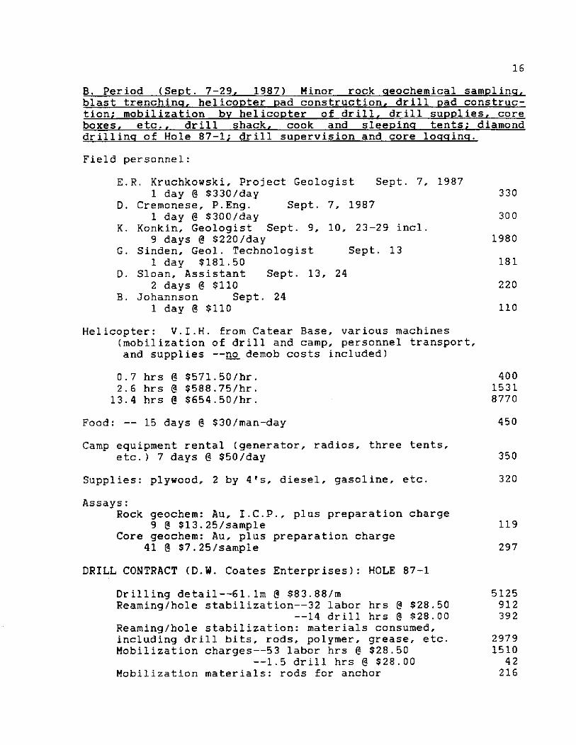
8. Period (Sept. 7-29, 19871 Minor rock aeochemical samplinq, blast trenchina, helicoDter Dad construction, drill pad construc- tion; mobilization bv helicopter of drill, drill supnlies, core boxes, etc.. drill shack, cook and sleeuina tents; diamond drillinq of Hole 87-l; drill supervision and core loaaina.
Field personnel:
E.R. Kruchkowski. Project Geologist Sept. 7, 1987 1 day 8 $330/day
D. Cremonese, P.Eng. Sept. 7, 1987 1 day @ $300/day
K. Konkin. Geologist Sept. 9. 10. 23-29 incl. 9 days @ $220/day
G. Sinden, Geol. Technologist Sept. 13 1 day $181.50
D. Sloan, Assistant Sept. 13, 24 2 days @ $110
B. Johannson Sept. 24 1 day @ $110
330
300
1980
181
220
110
Helicopter: V.I.H. from Catear Base, various machines (mobilization of drill and camp, personnel transport, and supplies --no demob costs included)
0.7 hi-s @ $571.50/hr. 2.6 hrs @ $588.75/hr.
13.4 hrs @ $654.50/hr.
400 1531 8770
Food: -- 15 days @ $30/man-day
Camp equipment rental (generator, radios, three tents. etc.) 7 days @ $50/day
450
350
Supplies: plywood, 2 by 4's, diesel, gasoline, etc. 320
Assays: Rock geochem: Au, I.C.P., plus preparation charge
9 @ $13.25/sample Core geochem: Au. plus preparation charge
41 @ $7.25/sample
119
297
DRILL CONTRACT (D.W. Coates Enterprises): HOLE 87-l
Drilling detail--6l.lm @ $83.88/m 5125 Reaming/hole stabilization--32 labor hrs @ $28.50 912
--14 drill hrs 8 $28.00 392 Reaming/hole stabilization: materials consumed, including drill bits, rods, polymer, grease, etc. Mobilization charges--53 labor hrs @ $28.50
--1.5 drill hrs @ $28.00 Mobilization materials: rods for anchor
2979 1510
42 216
Maintaining water lines: 4 labor hrs @ $28.50 Realign drill/set-up: 5.5 labor hrs @ $28.50 Core boxes Standby rate (waiting for helicopter)
27 labor Crew batching Camp work and
C. Report Costs
hrs @ $27.5 bonus : 6 days @ $200/day repairs: 8 labor hrs @ $28.50
Sub-Total . . . . . . . . .
17
114 157
85
742 1200
228
$ 29060
Report and map preparation, compilation and research 0. Cremonese, p.Eng.. 2 days @ $300/day 600
Draughting -- F. Chong 308 Word Processor - 5 hrs. @ $25/hr. 125 Copies, report, jackets, maps, etc. 70
Sub-Total .........I s 1103
GRAND TOTAL.......... $33.374
Work filed per Statement of Exploration and Development dated Sept. 30, 1987 . . . . . . . . . . $19,200
Extra [To be added to PAC account of Teuton Resources Corp. if possible]** . . . . ...*.. $14,174
**Not requested at time of filing of Statement because of lack of complete information re costs.
18
I. Dim M. Cremonese, do hereby certify that:
1.
2.
3.
4.
5.
6.
I am a mineral property consultant with an office at Suite ZOO-675 W. Hastings, Vancouver, B.C.
I am a graduate of the University of British Columbia (B.A.Sc. in metallurgical engineering, 1972, and L.L.B., 1979).
I am a Professional Engineer registered with the Association of Professional Engineers of the Province of British Columbia as a resident member, #13876.
I have practiced my profession since 1979
This report is based upon work carried out on the TR 4. 5. and 8 mineral claims, Skeena Mining Division in August and September of 1987. Reference to field notes and maps made by geologist Ken Konkin and geol. technologist G. Sinden is acknowledged. I have full confidence in the abilities of all samplers used in the 1987 geochemical program (K. Konkin and G. Sinden have well over 5 years experience each in the Stewart area alone) and am satisfied that all samples were taken properly and with care.
I am a principal of Teuton Resources Corp., owner of the TR 4, 5, and 8 claims: this report Was prepared solely for satisfying assessment work requirements in accordance with government regulations.
APPENDIX II - CERTIFICATE
Dated at Vancouver, B.C. this 28th day of December, 1987.
D. Cremonese. P.Eng.

19
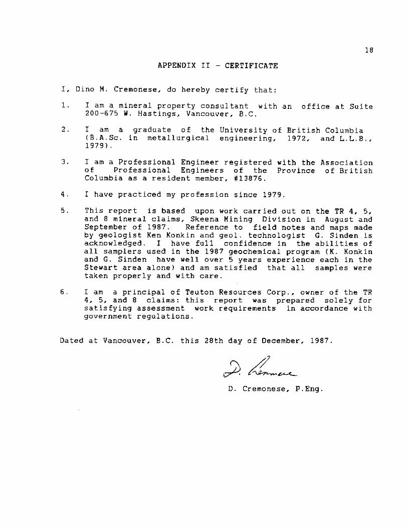
APPENDIX III
ASSAY CERTIFICATES

(m+lE ANALYTICAL L!2sOR~TdRT&a DFlTE RECEIVED! 052 E. HASTINGS ST. VFINCOUVER B.C. V6A 1Rb PHONE 253-3158 DFITv4 LINE 251-1011 DPTE REPORT MAILED:
GEOCHEMICAL :I CP ANALYS IS
,500 6RRN SANPLE IS DIGESTED YITH 3111 3-1-Z HCL-HNWQD AT 95 DE6.C FOR ONE HOUR RND IS OllUTED TO 10 NL NITH NATER. THIS LEhCH I5 PARTIRL FOR NW FE CA P CA CR 116 BR TI B Y AND LINITED FOR WA AND K, RU DETECIION LIMIT BY ICP I5 3 PPN. - SRNPLE IYPEI PI-S ROCK PI-3 SOIL AU* RNRLYSI! BY Ad CRON IO BRAN BANPLE,
4SSRYEH: . j+
DEAN TOYE, CERTIFIED B.C. WSAYER
TEUTON RESOURCES F~ i i e H Et:7.-:7biYi6 iF3qe j
$;ApjpL.f:fi ii ri fW*
FPM PPij
9 ,. .-_ .., *
I .U ,
I .̂ 44&a . . ,..-I
. 'L. I ,_,..,I

.1 S\ STD C/AIJ-R 7.5 5 1 ij
ACME ANALYTICAL LABORATORIES LTD. R52 E
DFITE RECEIVED HASTINGS, VANCOUVER B.C.
I: (6&l) 253-3158 COMPUTER LINE: 251-1011 DfiTE REFORTS


ACME i+NEILYTICAL LABORATDRTES LTD. DFlTE RECEIVEDI OCT 10 1987 852 E. HCISTINQB ST. VRNCCUVER B.C. v4a 1Rb PHONE ~604~233-3158 FFlX (&04)253-171&DATE REPORT MAILED1 .Q&
P ,,
csEaCHBMICfiL TCP mNCSLYsIs
- SMPLE ml core MM WV8fS LV AA FRDll 10 BUM WE,
ABBAYERI . . DEAN TOYE, CERTIFIED B.C. fiBSAYER
TEUTON R SOURCES CORP. File Y W-4771 Page 1
.
SAMPLE44 AU* PPb
2620 1 25 26202 61 26203 9 ---I. 26204 29 26205 88
26206 25 26207 11 26208 49 262OY 580 2hZ10 420
26211 215 26212 92 26213 645 26214 128 26215 146
26216 485 26217 220 26218 111 26219 64 26220 96
26221 81 26222 156 26223 169 26224 102 26225 03
26226 146 26227 1820 26228 610 26229 520 26230 i68
26231 121 26232 255 26233 350 26234 32 26235 230
26236 485
.

OCT 13 ‘87 14:29 FiCME LABS 553 Pa2
TEUTOW REBllURCW CORP. IFILE II 87-4771 Page 2
SCIMF’L.E% Nur
PPb
26237 3 1. cl 24238 61 Cl 2623’9 270 26240 520 2c124 I 690

20
APPENDIX IV
DRILL LOGS
PA' 1 of 4
E.R. KRUCHKOWSKI CONSULTING
PROPERTY TREATY #l GROUP DATE STARTED 26 Sept/87 FINISHED 29 Sept/87
DRILL HOLE T-87-l DEPTH 61.1 m DIP -46O BEARING 65'
ASSAYS 5/2E.’ &Q a.c.
IN GOLD INTERVAL METERS SAMPLE fi IN PPB DESCRIPTION --
1.8 1.8 Casing; overburden
l.B- 61.1 Skarn assemblage; altered lithic-xtl. andesite tuff, moderately siliceous dolomitic skarn assemblage
Ii s arned volcanics), med.-dk. green & pale - med. green - ., mod-strong rhodochrosite and (hem. ?) along fault
planes, skarn consists of diopside, epidole, specular hem.atite, calcite, chlorite, and pyrite chalco- pyrite as sulphide mineralization. Minor quartz-calcite (qtz-cal) veinlets, mod-intense vugs and limonite oxidation (lim. ox.) along fract. planes and shears.
1.8- 4.3 26201
4.3- 5.9 26202
5.9- 6.9 26203
6.9- 8.8 26204
8.8- 10.4 26205
10.4- 11.6 26206
11.6- 13.2 26207
13.2- 14.9 26208
14.9- 16.5 26209
25
62
9
29
88
25
11
49
580
-50% recovery, graveled blocky core, intense chl- epidote and rhodochrosite (hem. ?), weak-mod skarn alt. Tr. 1% v.f.g. diss. py.
95% recovery, strong skarn, 2-3% f.g.-c.g. diss. py.
95% recovery, strong skarn, 2-3% f.g.-c.g. diss. py.
95% recovery, strong skarn, 2-3% f.g.-c.g. diss. py.
95% recovery, strong skarn, 2-3% f.g.-c.g. diss. py.
Mod.-strong skarn, 2-3% f.g.-c.g. diss. py.
Well fract. weak skarn, fractured core.
Weakly skarned, ep-chl alt, lith-xtl tuff, Tr. f.g. Py.
Weakly skarned, ep-chl alt, lith-xtl tuff, Tr. f.g. Py.
E.R. KRUCHKOWSKI CONSULTING
PROPERTY TREATY #l GROUP
DRILL HOLE T-87-l
DATE STARTED 26 Sept/87 FINISHED 29 Sept/87
DEPTH 61.1 m DIP -46* BEARING 65*
INTERVAL METERS
16.5- 18.0
SAMPLE J&
ASSAYS GOLD IN -- IN PPB --
26210 420
18.0- 19.8 26211 215
19.8- 21.0 26212 92
21.0- 21.6 26213 645
21.6- 24.1 26214 128
24.1- 25.6 26215 146
25.6- 26.8 26216 485
26.8- 30.2 26217 220
30.2- 31.4
31.4- 33.3
26218
26219
111
64
32.6- 33.3 96
PAGE f 4
DESCRIPTION
Weakly skarned, ep-chl alt., lith-xtl tuff, Tr. f.g. Py.
Mod.. skarn l-2% f.g.-c.g. diss. Py. Strong calcite @ 19.23-19.26.
Weak skarn, chalcopyrite + chl. alt. lith-xtl tuff, Tr. f.g. Py.
50% recovery 5-7% f.g.-c.g. diss. py, weak-mod skarn.
50% recovery, 5-7% f.g.-c.g. diss. Py., weak-mod skarn.
80% recovery, 3-5% f.g.-c.g. diss. Py. weak-mod skarn.
7-10% recovery, 7-10% f.g.-c.g. diss. Py. weak-mod skarn.
Oxidized zone; intense limonite oxidation (lim. ox.), 7- :ss Py + 1% c.p.
Mod. dolomite skarn, 3-5% f.g.-c.g. Py + 1% Cp.
Mod. dolomite -Cal. skarn, I-2% f.g.-c.g. Py 4 1% cp.
Shattered core, gouge 9 108 & 109, lo-15% diss. py.
10%

PAG' 1of4
E.R. KRUCHKOWSKI CONSULTING
PROPERTY TREATY #l GROUP
& HOLE T-87-l
DATE STARTED 26 Sept/87 FINISHED 29 Sept/87
DEPTH 61.1 m DIP -46O BEARING 65'
INTERVAL METERS SAMPLE JI&
50.0- 52.0 26232
52.0- 52.6 26233
52.6- 53.0 26234
53.0- 55.0 26235
55.0- 55.8 26236
55.8- 56.7 26237
56.7- 57.3 26238
57.3-58.8 26239
58.8- 60.3 26240
60.3- 61.1 26241
ASSAYS GOLD IN
PPB IN
255
350
32
230
685
310
610
270
520
640
DESCRIPTION
Strong, silicified cal skarn; 3-5% f.g.-c.g. diss. Py.
1 cm qtz. veinlet, intense limonite oxidation (lim. ox.), 5-7 % c.g. diss. Py.
Strong silicified cal skarn 2-3% f.g.-c.g. diss Py.
Strong silicified cal skarn, 3-5% f.g.-c.g. diss. Py.
Strong silicified cal skarn, 2-3% f.g.-c.g. diss Py.
Strong silicified cal skarn, 2-3 f.g.-c.g. diss. Py.
Strong silicified cal skarn, 15-20% f.g.-c.g. Diss. Py.
Strong silicified cal skarn 3-54: f.g-c.g. Diss. Py.
Strong silicified cal skarn, 3-5X: f.g.-c.g. Diss. Py.
75% recovery, 25-30% f.g.- c.g. Diss. Py.

E.R. KRUCHKOWSKI CONSULTING
PROPERTY TREATY #l GROUP
DRILL HOLE T-87-l
PAGL of 4
DATE STARTED 26 Sept./87 FINISHED 29 Sept/87
DEPTH 61.1 m DIP -46' BEARING 65'
INTERVAL METERS SAMPLE NO.
33.3- 34.7 26221
ASSAYS GOLD IN IN PPB
81
34.7- 36.3 26222 156
36.3- 38.1 26223 169
38.1- 39.3 26224 102
39.3- 40.5 26225 83
40.5- 41.2 26226 146
41.2- 43.0 26227 1820
43.0- 45.4
45.4- 46.9
26228 610 10% recovery 20-25% diss. f.g.-c.g. Py.
26239 520
46.9- 48.5 26230 168
48.5- 50.0 26231 121
DESCRIPTION
Med-strong silicified skarn, 7-lo%, f.g-c.g. diss. Py.
Mod.. skarn, 5-7% f.g.-c.g. diss. f.g.-c.g. diss. Py.
Mod. dol-cal skarn, 2-38 f.g.-c.g. diss. Py.
Mod. dol-cal skarn, 3-5% f.g.-c.g. diss. Py.
Mod. dol-cal skarn, 3-58 f.g.-c.g. diss. Py.
Mod.-strong dol-cal skarn, lo-15% f.g.-c.g., diss. Py., limonite oxidation (lim. ox.).
60% recovery, 30-35X: diss. interstitial c.g. Py.
90% recovery, shattered core, blocky dol- cal skarn, 5% Py.
90% recovery, shattered core, blocky dol- cal skarn 5% Py.
100% reovery, block core, strong dol- cal skarn, 3-5% Py.