Embed Size (px)
Citation preview
Procedia Earth and Planetary Science 12 ( 2015 ) 20 – 30
1878-5220 © 2015 The Authors. Published by Elsevier B.V. This is an open access article under the CC BY-NC-ND license (http://creativecommons.org/licenses/by-nc-nd/4.0/).Peer-review under responsibility of the Scientific Committee of ISEDM 2013doi: 10.1016/j.proeps.2015.03.007
Available online at www.sciencedirect.com
ScienceDirect
ISEDM 2013
3rd International Symposium on Earthquake and Disaster Mitigation
Assessment on the characteristics and the damping performance of coastal forests in Pangandaran after the 2006 Java Tsunami
Semeidi Husrin1* , Jaya Kelvin2, Aprizon Putra1, Joko Prihantono3, Yudhi Cara4, Aditya Hani5
1 Research Institue for Coastal Resources and Vulnerability, Ministry of Marine Affairs and Fisheries
Jl. Raya Padang- Painan Km 16 Padang 25245, Sumatera Barat, INDONESIA 2Faculty of Fisheries and Marine Sciences, Universiy of Padjadjaran Jl. Raya Bandung Sumedang Km 21, Jatinangor 40600, INDONESIA
3Research Centre for Coastal and Marine Resources, Ministry of Marine Affairs and Fisheries Jl. Pasir Putih I Lantai 3, Ancol Timur, Jakarta Utara 14430 – DKI Jakarta, INDONESIA
4Geological Agency, Ministry of Energy and Mineral Resources Jl. Diponegoro 57, Bandung 40122, Jawa Barat, INDONESIA
5Forestry Research Institute, Ministry of Forestry Jl. Raya Ciamis-Banjar Km 4 Ciamis 46201, Jawa Barat, INDONESIA
Abstract
The use of coastal forests as natural tsunami barrier has long been the source of controversies due to inconclusive understanding on the damping performance and contradictory field findings from the last tsunami events. After experiencing hundreds of casualties and severe destruction on the infrastructures due to the 2006 South Java Tsunami, the coastline of Pangandaran district in West Java was replanted by coastal forest vegetation to mitigate future tsunami as well as improving the quality of the environment. The design of coastal forests along the coastline of Pangandaran adopted divide-and-rule strategy concept. Considering their physical and biological aspects as well as the ability to withstand hydraulic forces. This concept requires different species at different locations perpendicular to the coastline with staggered formations in order to provide optimum damping performance of the coastal forests. Unfortunately, this concept has never been quantified or hydraulically tested against extreme cases like tsunami. The paper will present the characteristics and the latest conditions of coastal forests in Pangandaran including the problems and the challenge of this mitigation system in the last five years. Moreover, damping performance of the coastal forests was also investigated by means of Nonlinear Shallow Water Equation Model to quantify the contribution of coastal forest and other existing environmental aspects such as the bathymetry and the topography to the total tsunami attenuation. Based on the obtained wave transmission, the simulation analysis shows that the
21 Semeidi Husrin et al. / Procedia Earth and Planetary Science 12 ( 2015 ) 20 – 30
characteristics of bathymetry and topography along the coastline play significant role in reducing the impact of tsunami compared to the coastal forests. © 2014 The Authors. Published by Elsevier B.V. Peer-review under responsibility of the Scientific Committee of ISEDM 2013
Keywords: Pangandaran; tsunami; coastal forest; mitigation; damping performance
* Corresponding author. Tel.: +6262751751458; fax: 6262751751458. E-mail address: [email protected], [email protected]
1. Background
Coastal forests have been considered by many parties as one of mitigation measures against tsunamis. Japan has long started the use of coastal forest as one of tsunami protection measures e.g. along the coastline of Sendai. 1 was among the first who published quantitatively on the relationships of tsunami heights and coastal forest vegetation characteristics (e.g. trunk diameter and tree height) based on the data from the five largest historical tsunami events in Japan. Based on field observations, experienced damage, and satellite images of the last tsunami events, some reports have apparently shown significant role of coastal forest in reducing the impact of tsunamis2,3. Others supported those findings based on semi-analytical and empirical approaches through experiments with both physical and numerical models4,5,6,7. The 2011 Japan Tsunami, however, have provided us completely different facts where many coastal forest were completely destroyed by the extreme tsunami. Moreover, previous tsunami events such as the 2009 Chilean Tsunami and the 2010 Mentawai Tsunami have also revealed evidence of the inability of coastal forest against the impact of extreme tsunami. Thus, some have concluded that coastal forest were not always protective and the final conclusion on the effectiveness of coastal forest as coastal tsunami barrier still cannot be drawn8,9,10. The large uncertainties associated with tsunami onshore propagation, the effect of complex bathymetry and topography, and vegetation behaviours against tsunami force illustrate some of the poorly understood aspects. Based on the analysis of physical model using parameterized tree models, 11 concluded that the foreshore topography and bathymetry characteristics play significant role in reducing the impact of tsunami. Additionally, coastal forests will hardly provide protection for large tsunami reaching the canopy of the tree or beyond due to structural stability problems (i.e. uprooted or broken trunks).
After the 2004 Aceh tsunami, coastal forests has been implemented extensively for tsunami mitigation measures in several areas in Indonesians islands, mostly in Java and Sumatera. The latest “greenbelt project” sponsored by the Ministry of Marine Affairs and Fisheries have planted coastal pine tress (Casuarina Equisetifolia) along the coastal area of Pesisir Selatan Regency, West Sumatera Province12. Though the effectiveness of coastal forest for tsunami mitigation measures is still in discussions, coastal forest has been considered as the most favourable due to other additional functions such as for environmental improvement of the coastal area. Pangandaran district in West Java Province suffered heavy destruction due to the 2006 South Java Tsunami and killed hundreds of people. Tsunami run-up heights were measured up to 15.7 m and the inundation distance reached hundreds of metres13. Immediately after the event, the central government and local institutions launched a replantation project of coastal area along Pangandaran. Different species were planted and arranged in different configuration to provide short of protections against tsunami flow. Therefore, this paper describes the characteristics of coastal forests along the coastline of Pangandaran for the purpose of tsunami mitigation measures. The objective of the current study will focus on the analysis of tsunami attenuation by coastal forest
© 2015 The Authors. Published by Elsevier B.V. This is an open access article under the CC BY-NC-ND license (http://creativecommons.org/licenses/by-nc-nd/4.0/).Peer-review under responsibility of the Scientific Committee of ISEDM 2013
22 Semeidi Husrin et al. / Procedia Earth and Planetary Science 12 ( 2015 ) 20 – 30
and by other environmental features (topography and bathymetry) by reproducing the 2006 South Java Tsunami numerically (Nonlinear Shallow Water Equation Model) using the latest available data.
2. Methodology
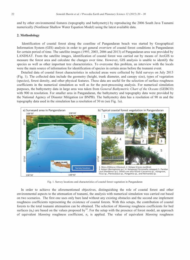
Identification of coastal forest along the coastline of Pangandaran beach was started by Geographical Information System (GIS) analysis in order to get general overview of coastal forest conditions in Pangandaran for certain period of time. The satellite images (1993, 2003, 2006 and 2013) of Pangandaran area was provided by LANDSAT. From the satellite images, identification of coastal forest was carried out by means of ArcGIS to measure the forest area and calculate the changes over time. However, GIS analysis is unable to identify the species as well as other important tree characteristics. To overcome this problem, an interview with the locals were the main source of information for identification of species in certain areas before the tsunami event.
Detailed data of coastal forest characteristics in selected areas were collected by field surveys on July 2013 (Fig. 1). The collected data include the geometry (height, trunk diameter, and canopy size), types of vegetation (species), forest density, and other physical features. These data are useful for the selection of surface roughness coefficients in the numerical simulation as well as for the post-processing analysis. For numerical simulation purposes, the bathymetry data in large area was taken from General Bathymetric Chart of the Oceans (GEBCO) with 900 m resolution. For smaller area in Pangandaran, the bathymetry and topography data were provided by the National Agency of Disaster Mitigation (or BNPB). The bathymetry data has a resolution of 90 m and the topography data used in the simulation has a resolution of 30 m (see Fig. 1a).
108o30’ 108o40’
07o 5
0’07
o 40’
108o30’ 108o40’
07o 5
0’07
o 40’
Survey location
a) Surveyed area in Pangandaran b) Typical coastal forest vegetation in Pangandaran
1. Waru (Hibiscus tiliaceus), 2. Kelapa (Cocos nucifera)3. Keben (Baringtonia sp.), 4. Ketapang (Terminalia catappa) 5. Pandan Laut (Pandanus sp.). Others are also found: Casuarina sp., mangrove, Ficus sp., Pterocarpus sp., Pongamia sp., and Hernandia sp.
1
2 34
5
Fig. 1. Survey locations and characteristics of coastal forest vegetation in Pangandaran
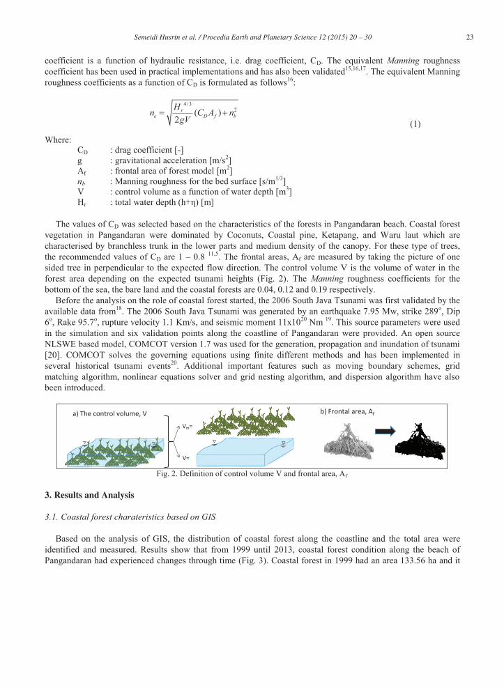
In order to achieve the aforementioned objectives, distinguishing the role of coastal forest and other environmental aspects to the attenuation of tsunami, the analysis with numerical simulation was carried out based on two scenarios. The first one uses only bare land without any existing obstacles and the second one implement roughness coefficients representing the existence of coastal forests. With this setups, the contribution of coastal forests to the total tsunami attenuation can be obtained. The selection of Manning roughness coefficients for bed surfaces (nb) are based on the values proposed by14. For the setup with the presence of forest model, an approach of equivalent Manning roughness coefficient, ne is applied. The value of equivalent Manning roughness
23 Semeidi Husrin et al. / Procedia Earth and Planetary Science 12 ( 2015 ) 20 – 30
coefficient is a function of hydraulic resistance, i.e. drag coefficient, CD. The equivalent Manning roughness coefficient has been used in practical implementations and has also been validated15,16,17. The equivalent Manning roughness coefficients as a function of CD is formulated as follows16:
4/3
2( )2
re D f b
Hn C A ngV (1)
Where: CD : drag coefficient [-] g : gravitational acceleration [m/s2] Af : frontal area of forest model [m2] nb : Manning roughness for the bed surface [s/m1/3] V : control volume as a function of water depth [m3] Hr : total water depth (h+η) [m]
The values of CD was selected based on the characteristics of the forests in Pangandaran beach. Coastal forest
vegetation in Pangandaran were dominated by Coconuts, Coastal pine, Ketapang, and Waru laut which are characterised by branchless trunk in the lower parts and medium density of the canopy. For these type of trees, the recommended values of CD are 1 – 0.8 11,5. The frontal areas, Af are measured by taking the picture of one sided tree in perpendicular to the expected flow direction. The control volume V is the volume of water in the forest area depending on the expected tsunami heights (Fig. 2). The Manning roughness coefficients for the bottom of the sea, the bare land and the coastal forests are 0.04, 0.12 and 0.19 respectively.
Before the analysis on the role of coastal forest started, the 2006 South Java Tsunami was first validated by the available data from18. The 2006 South Java Tsunami was generated by an earthquake 7.95 Mw, strike 289o, Dip 6o, Rake 95.7o, rupture velocity 1.1 Km/s, and seismic moment 11x1020 Nm 19. This source parameters were used in the simulation and six validation points along the coastline of Pangandaran were provided. An open source NLSWE based model, COMCOT version 1.7 was used for the generation, propagation and inundation of tsunami [20]. COMCOT solves the governing equations using finite different methods and has been implemented in several historical tsunami events20. Additional important features such as moving boundary schemes, grid matching algorithm, nonlinear equations solver and grid nesting algorithm, and dispersion algorithm have also been introduced.
b) Implementation of submerged volume ratio (Vm/V) in the field: Vm=
V=
b) Frontal area, Afa) The control volume, V
Fig. 2. Definition of control volume V and frontal area, Af
3. Results and Analysis
3.1. Coastal forest charateristics based on GIS
Based on the analysis of GIS, the distribution of coastal forest along the coastline and the total area were identified and measured. Results show that from 1999 until 2013, coastal forest condition along the beach of Pangandaran had experienced changes through time (Fig. 3). Coastal forest in 1999 had an area 133.56 ha and it
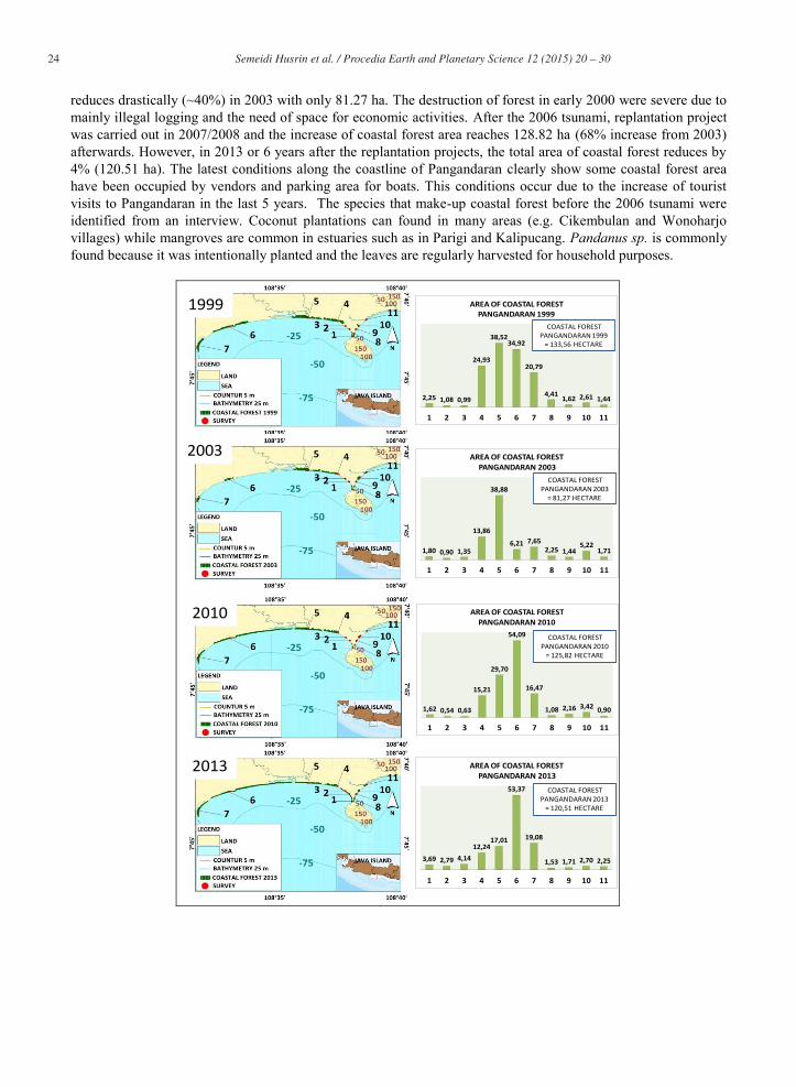
24 Semeidi Husrin et al. / Procedia Earth and Planetary Science 12 ( 2015 ) 20 – 30
reduces drastically (~40%) in 2003 with only 81.27 ha. The destruction of forest in early 2000 were severe due to mainly illegal logging and the need of space for economic activities. After the 2006 tsunami, replantation project was carried out in 2007/2008 and the increase of coastal forest area reaches 128.82 ha (68% increase from 2003) afterwards. However, in 2013 or 6 years after the replantation projects, the total area of coastal forest reduces by 4% (120.51 ha). The latest conditions along the coastline of Pangandaran clearly show some coastal forest area have been occupied by vendors and parking area for boats. This conditions occur due to the increase of tourist visits to Pangandaran in the last 5 years. The species that make-up coastal forest before the 2006 tsunami were identified from an interview. Coconut plantations can found in many areas (e.g. Cikembulan and Wonoharjo villages) while mangroves are common in estuaries such as in Parigi and Kalipucang. Pandanus sp. is commonly found because it was intentionally planted and the leaves are regularly harvested for household purposes.
2,25 1,08 0,99
24,93
38,5234,92
20,79
4,411,62 2,61 1,44
1 2 3 4 5 6 7 8 9 10 11
AREA OF COASTAL FOREST PANGANDARAN 1999
COASTAL FOREST PANGANDARAN 1999
= 133,56 HECTARE
1,80 0,90 1,35
13,86
38,88
6,21 7,652,25 1,44
5,221,71
1 2 3 4 5 6 7 8 9 10 11
AREA OF COASTAL FORESTPANGANDARAN 2003
COASTAL FOREST PANGANDARAN 2003
= 81,27 HECTARE
1,62 0,54 0,63
15,21
29,70
54,09
16,47
1,08 2,16 3,42 0,90
1 2 3 4 5 6 7 8 9 10 11
AREA OF COASTAL FOREST PANGANDARAN 2010
COASTAL FOREST PANGANDARAN 2010
= 125,82 HECTARE
3,69 2,79 4,1412,24
17,01
53,37
19,08
1,53 1,71 2,70 2,25
1 2 3 4 5 6 7 8 9 10 11
AREA OF COASTAL FORESTPANGANDARAN 2013
COASTAL FOREST PANGANDARAN 2013
= 120,51 HECTARE
1999
2003
2010
2013
25 Semeidi Husrin et al. / Procedia Earth and Planetary Science 12 ( 2015 ) 20 – 30
Fig. 3. Coastal forest conditions in Pangandaran based on GIS analysis
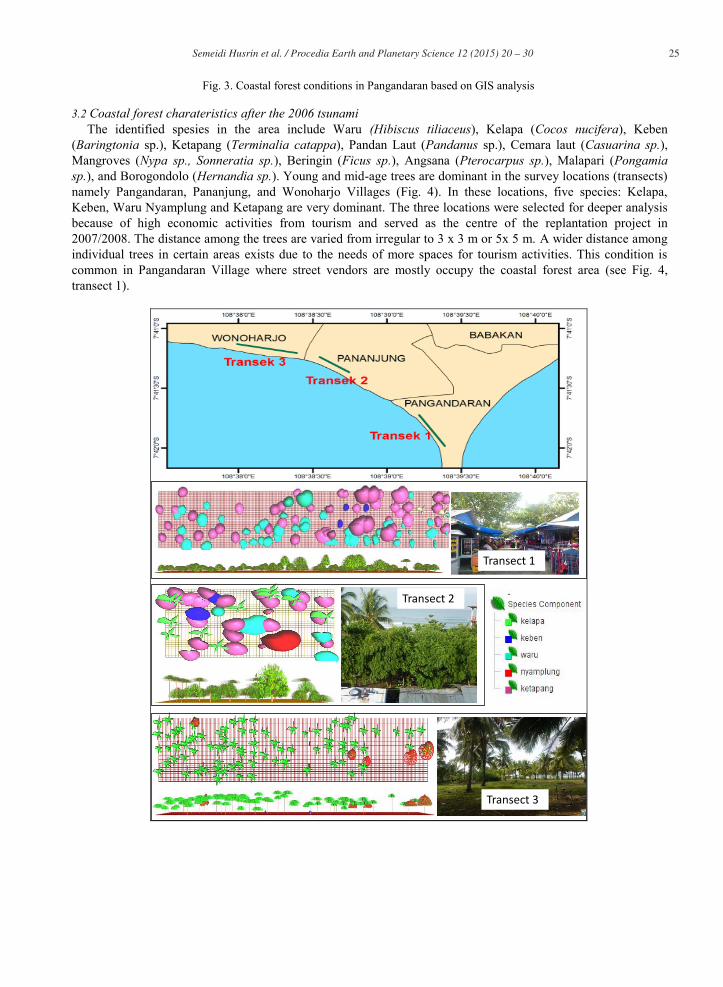
3.2 Coastal forest charateristics after the 2006 tsunami The identified spesies in the area include Waru (Hibiscus tiliaceus), Kelapa (Cocos nucifera), Keben
(Baringtonia sp.), Ketapang (Terminalia catappa), Pandan Laut (Pandanus sp.), Cemara laut (Casuarina sp.), Mangroves (Nypa sp., Sonneratia sp.), Beringin (Ficus sp.), Angsana (Pterocarpus sp.), Malapari (Pongamia sp.), and Borogondolo (Hernandia sp.). Young and mid-age trees are dominant in the survey locations (transects) namely Pangandaran, Pananjung, and Wonoharjo Villages (Fig. 4). In these locations, five species: Kelapa, Keben, Waru Nyamplung and Ketapang are very dominant. The three locations were selected for deeper analysis because of high economic activities from tourism and served as the centre of the replantation project in 2007/2008. The distance among the trees are varied from irregular to 3 x 3 m or 5x 5 m. A wider distance among individual trees in certain areas exists due to the needs of more spaces for tourism activities. This condition is common in Pangandaran Village where street vendors are mostly occupy the coastal forest area (see Fig. 4, transect 1).
Transect 1
Transect 2
Transect 3
26 Semeidi Husrin et al. / Procedia Earth and Planetary Science 12 ( 2015 ) 20 – 30
Fig. 4. Coastal forest conditions in Pangandaran based on field survey in 2013
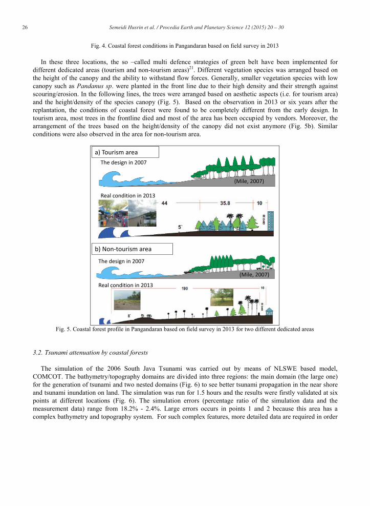
In these three locations, the so –called multi defence strategies of green belt have been implemented for different dedicated areas (tourism and non-tourism areas)21. Different vegetation species was arranged based on the height of the canopy and the ability to withstand flow forces. Generally, smaller vegetation species with low canopy such as Pandanus sp. were planted in the front line due to their high density and their strength against scouring/erosion. In the following lines, the trees were arranged based on aesthetic aspects (i.e. for tourism area) and the height/density of the species canopy (Fig. 5). Based on the observation in 2013 or six years after the replantation, the conditions of coastal forest were found to be completely different from the early design. In tourism area, most trees in the frontline died and most of the area has been occupied by vendors. Moreover, the arrangement of the trees based on the height/density of the canopy did not exist anymore (Fig. 5b). Similar conditions were also observed in the area for non-tourism area.
The design in 2007
Real condition in 2013
The design in 2007
Real condition in 2013
a) Tourism area
b) Non-tourism area
(Mile, 2007)
(Mile, 2007)
Fig. 5. Coastal forest profile in Pangandaran based on field survey in 2013 for two different dedicated areas
3.2. Tsunami attenuation by coastal forests
The simulation of the 2006 South Java Tsunami was carried out by means of NLSWE based model, COMCOT. The bathymetry/topography domains are divided into three regions: the main domain (the large one) for the generation of tsunami and two nested domains (Fig. 6) to see better tsunami propagation in the near shore and tsunami inundation on land. The simulation was run for 1.5 hours and the results were firstly validated at six points at different locations (Fig. 6). The simulation errors (percentage ratio of the simulation data and the measurement data) range from 18.2% - 2.4%. Large errors occurs in points 1 and 2 because this area has a complex bathymetry and topography system. For such complex features, more detailed data are required in order
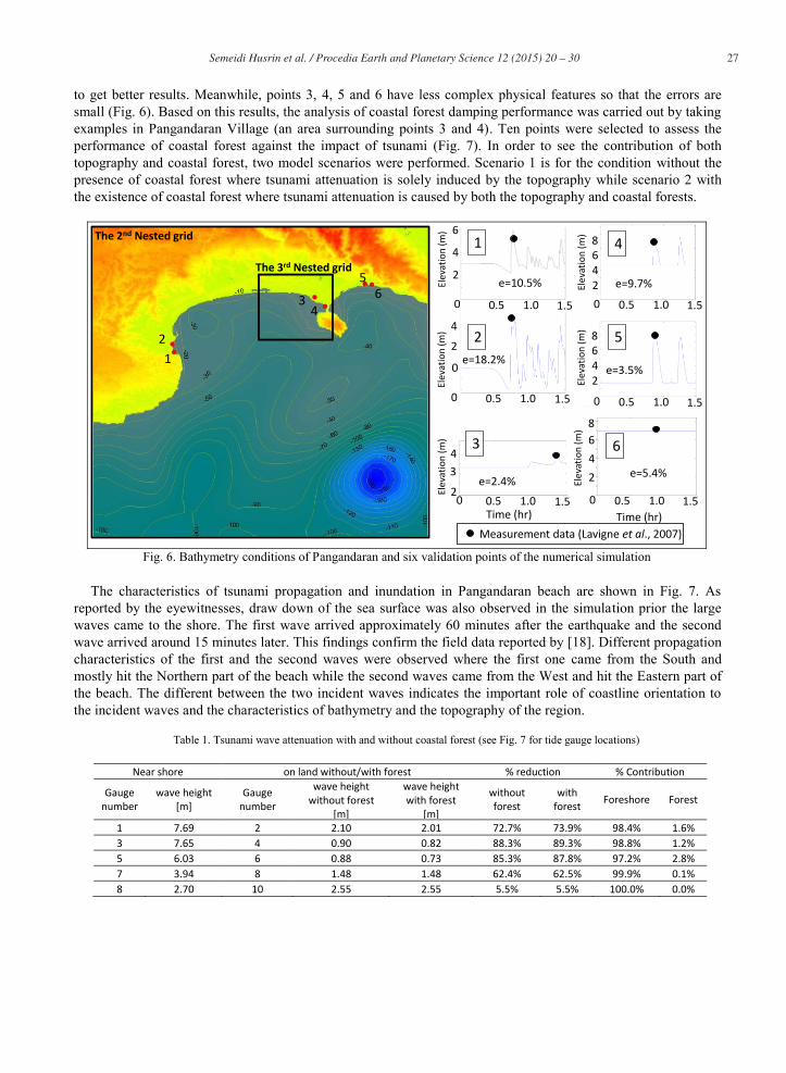
27 Semeidi Husrin et al. / Procedia Earth and Planetary Science 12 ( 2015 ) 20 – 30
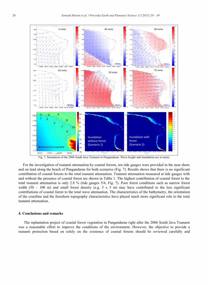
to get better results. Meanwhile, points 3, 4, 5 and 6 have less complex physical features so that the errors are small (Fig. 6). Based on this results, the analysis of coastal forest damping performance was carried out by taking examples in Pangandaran Village (an area surrounding points 3 and 4). Ten points were selected to assess the performance of coastal forest against the impact of tsunami (Fig. 7). In order to see the contribution of both topography and coastal forest, two model scenarios were performed. Scenario 1 is for the condition without the presence of coastal forest where tsunami attenuation is solely induced by the topography while scenario 2 with the existence of coastal forest where tsunami attenuation is caused by both the topography and coastal forests.
12
34
56
6
4
2
Elev
atio
n (m
)
0.5 1.0 1.50
Elev
atio
n (m
) 4
2
0
0.5 1.0 1.50
0.5 1.0 1.50
43
2Elev
atio
n (m
)
864
Elev
atio
n (m
)
20.5 1.0 1.50
864
Elev
atio
n (m
)
2
0.5 1.0 1.50
864
Elev
atio
n (m
)
2
0 0.5 1.0 1.50Time (hr) Time (hr)
1
2
3
4
5
6
e=10.5%
e=18.2%
e=2.4%
e=9.7%
e=3.5%
e=5.4%
Measurement data (Lavigne et al., 2007)
The 3rd Nested grid
The 2nd Nested grid
Fig. 6. Bathymetry conditions of Pangandaran and six validation points of the numerical simulation
The characteristics of tsunami propagation and inundation in Pangandaran beach are shown in Fig. 7. As
reported by the eyewitnesses, draw down of the sea surface was also observed in the simulation prior the large waves came to the shore. The first wave arrived approximately 60 minutes after the earthquake and the second wave arrived around 15 minutes later. This findings confirm the field data reported by [18]. Different propagation characteristics of the first and the second waves were observed where the first one came from the South and mostly hit the Northern part of the beach while the second waves came from the West and hit the Eastern part of the beach. The different between the two incident waves indicates the important role of coastline orientation to the incident waves and the characteristics of bathymetry and the topography of the region.
Table 1. Tsunami wave attenuation with and without coastal forest (see Fig. 7 for tide gauge locations)
Near shore on land without/with forest % reduction % Contribution
Gauge number
wave height [m]
Gauge number
wave height without forest
[m]
wave height with forest
[m]
without forest
with forest Foreshore Forest
1 7.69 2 2.10 2.01 72.7% 73.9% 98.4% 1.6% 3 7.65 4 0.90 0.82 88.3% 89.3% 98.8% 1.2% 5 6.03 6 0.88 0.73 85.3% 87.8% 97.2% 2.8% 7 3.94 8 1.48 1.48 62.4% 62.5% 99.9% 0.1% 8 2.70 10 2.55 2.55 5.5% 5.5% 100.0% 0.0%
28 Semeidi Husrin et al. / Procedia Earth and Planetary Science 12 ( 2015 ) 20 – 30
Bathymetry/topography
Inundation without forest(Scenario 1)
Inundation with forest (Scenario 2)
1 35
4 6
7
8
2
109
5 mnts
20 mnts
45 mnts
50 mnts
60 mnts
75 mnts
Fig. 7. Simulation of the 2006 South Java Tsunami in Pangandaran. Wave height and inundation are in metre
For the investigation of tsunami attenuation by coastal forests, ten tide gauges were provided in the near shore
and on land along the beach of Pangandaran for both scenarios (Fig. 7). Results shows that there is no significant contribution of coastal forests to the total tsunami attenuation. Tsunami attenuation measured at tide gauges with and without the presence of coastal forest are shown in Table 1. The highest contribution of coastal forest to the total tsunami attenuation is only 2.8 % (tide gauges 5/6, Fig. 7). Poor forest conditions such as narrow forest width (50 – 100 m) and small forest density (e.g. 5 x 5 m) may have contributed to the less significant contributions of coastal forest to the total wave attenuation. The characteristics of the bathymetry, the orientation of the coastline and the foreshore topography characteristics have played much more significant role to the total tsunami attenuation.
4. Conclusions and remarks
The replantation project of coastal forest vegetation in Pangandaran right after the 2006 South Java Tsunami was a reasonable effort to improve the conditions of the environment. However, the objective to provide a tsunami protection based on solely on the existence of coastal forests should be reviewed carefully and
29 Semeidi Husrin et al. / Procedia Earth and Planetary Science 12 ( 2015 ) 20 – 30
systematically, particmileularly the limitations should be clearly addressed. Data and preliminary studies in this paper showed that the new coastal forests along the Pangandaran beach may not provide any protection due to hydraulically unreliable, insufficient design as well as poor maintenance conditions. Aside from that, coastal forests ultimately have provided better coastal environmental conditions, erosion protection system from wind waves, and increased economic activities of the communities.
Acknowledgements
The research was funded by the Ministry of Marine Affairs and Fisheries fiscal year 2013 (DIPA 2013). We would like to thank Dr. Widjo Kongko from BPDP-BPPT for providing us the data and valuable advice. The contribution of all members in the research group of LPSDKP is also acknowledged.
References
1. Shuto, N., (1987). The effectiveness and limit of tsunami control forests, Coastal Engineering in Japan 30: pp.143-153. 2. Dahdouh-Guebas, F., L.P. Jayatissa, D. Di Nitto, J.O. Bosire, D. Lo Seen & N. Koedam, (2005). How effective were mangroves as a
defence against the recent tsunami ?, Current Biology 15(12): pp. 443-447. 3. Kathiresan & Rajendran, (2005). Coastal mangrove forests mitigated tsunami, Estuarine, Coastal and Shelf Science 65 (2005), pp. 601–
606. 4. Harada, K., and Imamura, F., (2000). Experimental study on the resistance by mangrove under the unsteady flow, In: Proceedings of the
1st congress of the Asian and Pacific Coastal Engineering, Dalian, pp 975–984. 5. Imai, K.; Matsutomi, H., (2005). Fluid force on vegetation due to the tsunami flow on sand spit, K. Satake (ed.), Tsunamis: Case Studies
& Recent Developments, pp. 293-304. 6. Latief, H., & Hadi, S., (2006). Protection from Tsunamis, Coastal Protection in the Aftermath of the Indian Ocean Tsunami’: What role
for forests and trees, Proceedings of the regional technical workshop, FAO, Khao Lak, Thailand. 7. Yanagisawa, H., Koshimura, S., Miyagi, T., and Imamura, F (2011). Tsunami damage reduction performance of a mangrove forest in
Banda Aceh, Indonesia inferred from field data and a numerical model, J. Geophys.Res., 115, C06032, doi:10.1029/2009JC005587 (http://dx.doi.org/10.1029/2009JC005587).
8. ECOS (2010). Coastal ‘bioshields’ no defence against tsunamis, ECOS, CSIRO Publishing,http://www.ecosmagazine.com/?paper=EC153p7a.
9. Kerr, AM., Baird, AH., Campbell, SJ. (2006). Comments on ‘‘Coastal mangrove forests mitigated tsunami by K. Kathiresan and N. Rajendran [Estuar. Coast. Shelf Sci. 65 (2005) 601e606], Estuarin’, Coastal and Shelf Science 67 (2006) pp. 539-541.
10. Wolansky, E. (2006). Thematic paper: Synthesis of the protective functions of coastal forests and trees against natural hazards, Coastal protection in the aftermath of the Indian Ocean tsunami, FAO Regional Office for Asia and the Pacific.
11. Husrin, S. (2013). The attenuation of solitary wave and wave trains by coastal forests, PhD Thesis, TU Braunschweig, Germany. 12. Antara, (2013).Pessel dapat bantuan mitigasi tsunami, AntaraNews, link: http://www.antarasumbar.com/berita/kab-pesisir-
selatan/d/15/316544/pessel-dapat-bantuan-mitigasi-tsunami.html, accssed date: 12 December 2013. 13. BMKG (2006). Survey tsunami pantai selatan jawa, Laporan tim survey BMKG, Jakarta. 14. Chow, V. T. (1959). Open channel hydraulics, McGraw-Hill Publishing Company, New York
(http://www.fsl.orst.edu/geowater/FX3/help/8_Hydraulic_Reference/Mannings_n_Tables.htm, accessed on November 2012). 15. Teh, S.Y., Koh, HL., Liu P.L-F., Ismail, A.I.M., Lee, H.L. (2009). Analytical and numerical simulation of tsunami mitigation by
mangrove in Penang, Malaysia, Journal of Asian Earth Sciences, 36(2009) pp. 38–46, doi:10.1016/j.jseaes.2008.09.007. 16. Yanagisawa, H., Koshimura, S., Goto, K., Miyagi,T., Imamura, F., Ruangrassamee, A. & Tanavud, C., (2009). The reduction effects of
mangrove forest on a tsunami based on field surveys at Pakarang Cape, Thailand and numerical analysis, Estuarine, Coastal and Self Sciences 81 (2009) pp. 27–37.
17. Kongko, W., (2004): ’Study On Tsunami Energy Dissipation In Mangrove Forest’, Master Thesis Report, Iwate University, Japan. 18. Lavigne, F., Gomes, C., Giffo, M., Wassmer, P., Hoebreck, C., Mardiatno, D., Prioyono, J., & Paris R., (2007). Field Observation of the
17 July 2006 Tsunami in Java, Natural Hazards and Earth Systems Sciences, 7: 177-183.
19. Ji, Chen. 2006. A Comparison Study of 2006 Java Earthquake and Other Tsunami Earthquakes. Poster. 2006 AGU Fall Meeting, S21A- 0125.
20. Wang, X. (2009). User Manual for Comcot Version 1.7 (First Draft), http://ceeserver.cee.cornell.edu/pll-group/comcot_down.htm.
30 Semeidi Husrin et al. / Procedia Earth and Planetary Science 12 ( 2015 ) 20 – 30
21. Mile, YM (2007). The Development of CoastalSpecies for Rehabilitation and Protection Coastal Regions After Ttsunami, INFO TEKNIS Vol. 5 no. 2, September 2007, Balai Besar Penelitian Bioteknologi dan Pemuliaan Tanaman Hutan (In Indonesian).
22. Kongko, W. (2012). South Java Tsunami Model Using Highly Resolved Data and Probable Tsunamigenic Sources, PhD-Dissertation, Leibniz Universität Hannover, Franzius-Institut für Wasserbau und Küsteningenieurwesen.