Embed Size (px)
Citation preview
Wyre Forest District Local Development Framework
Assessment of Potential Sites
for Gypsies, Travellers and Travelling Showpeople
August 2011
Wyre Forest District: Assessment of potential sites for Gypsies, Travellers and Travelling Showpeople
Final Report - August 2011 1
Contents Page 1. Introduction and Background 2 2. Methodology 4 3. Site Requirements 9 4. Site Criteria 22 5. Site Assessment 26 6. Capacity 31 7. Policy and delivery issues 32 8. Recommendations 41 Appendix 1: District site map Appendix 2: Stage 1 Site assessment matrix Appendix 3: Stage 2 Rejected sites Appendix 4: Shortlisted sites and sites for further investigation Appendix 5: Design templates
Wyre Forest District: Assessment of potential sites for Gypsies, Travellers and Travelling Showpeople
Final Report - August 2011 2
1 Introduction and Background
Introduction
1.1 Wyre Forest District Council has appointed Baker Associates to undertake an assessment of potential sites for Gypsies, Travellers and Travelling Showpeople.
1.2 The purposes of the Assessment are to:
• Undertake an independent assessment of potential sites for Gypsies, Travellers and Travelling Showpeople;
• Objectively identify suitable sites; • Develop a series of recommendations as to how the Council should develop
policies within the Site Allocations and Policies DPD. 1.3 The results of the Assessment will inform the development of relevant policies for
inclusion within the Wyre Forest Site Allocations and Policies DPD and the identification of suitable sites to meet needs and requirements.
Background
1.4 Gypsies and Travellers have lived in Britain for at least 500 years and probably
longer. For the purposes of the planning system, Gypsies and Travellers means
Persons of nomadic habit of life whatever their race or origin, including such persons who on grounds only of their own or their family’s or dependants’ educational or health needs or old age have ceased to travel temporarily or permanently, but excluding members of an organised group of Travelling Showpeople or circus people travelling together as such (Circular 01/06)
1.5 Many Gypsies and Travellers continue to pursue an active itinerant lifestyle and are
generally self employed people. However, increasingly communities are becoming more settled.
1.6 Gypsies and Travellers are not a uniform homogeneous community, but rather a
group of communities which share some features but have their own histories and traditions. Even within each main group there is fragmentation between different families which emphasises the lack of a cohesive community and the need to avoid over generalisations. However, the main cultural groups include:
(1) Romany Gypsies (2) Irish Travellers (3) New Travellers
Wyre Forest District: Assessment of potential sites for Gypsies, Travellers and Travelling Showpeople
Final Report - August 2011 3
1.7 Romany Gypsies and Irish Travellers are recognised in law as distinct ethnic groups
and are legally protected from discrimination under the Race Relations Acts. 1.8 Travelling Showpeople have traditionally been involved in holding fairs and circuses
for many hundreds of years. For the purposes of the planning system, Travelling Showpeople means
Members of a group organised for the purposes of holding fairs, circuses or shows (whether or not travelling together as such). This includes such persons who on the grounds of their family’s or dependant’s more localized pattern of trading, educational or health needs or old age have ceased to travel temporarily or permanently, but excludes Gypsies and Travellers as defined in ODPM Circular 01./2006 (Circular 04/2007)
1.9 The Government published two new Circulars in 2006 and 2007 to address future
accommodation needs of Gypsies, Travellers and Travelling Showpeople because the previous planning policy arrangements had failed to deliver adequate sites to meet identified needs over the previous 10 years.
1.10 Local planning authorities are currently required to identify and allocate sufficient
sites to meet the needs of these groups within their LDF. 1.11 In April 2011 the Government published a consultation on “Planning for traveller
sites” which proposes the introduction of a new Planning Policy Statement to replace the current Circulars. However, the Government’s objective remains for local planning authorities to meet need through the identification of land for sites.
1.12 The main purpose of this Assessment has been to identify a shortlist of potential
sites for Gypsies, Travellers and Travelling Showpeople to meet future needs which Wyre Forest District Council can now consider further through the statutory planning process.
Wyre Forest District: Assessment of potential sites for Gypsies, Travellers and Travelling Showpeople
Final Report - August 2011 4
2 Methodology 2.1 This section sets out in detail the methodology we have followed to deliver the
outputs sought from the Assessment. 2.2 Stages 1 to 3 involved an inception meeting and gathering relevant information
regarding issues and needs in order to establish at stage 4 the site assessment criteria.
2.3 Following this work, stages 5 to 7 involved identifying a shortlist of potential sites
through site survey and through the application of assessment criteria. 2.4 Stage 8 involved the generation of potential policy options and stage 9 involved the
development of specific recommendations to take forward the sites into the Site Allocations and Policies DPD.
Stage 1 Inception Meeting 2.5 The first stage involved discussing and agreeing with the Council a proposed
project plan for the Assessment at the Inception Meeting. This involved setting out the management arrangements, including the role of the project team and the consultants, the resources for the project, including budget and staffing levels and the work programme and project milestones.
2.6 At the Inception meeting we explored the issues relating to the Assessment and
gained initial views from the project team on the scope and contents of the agreed outputs. We discussed in particular:
• A detailed methodology for the Assessment to ensure a seamless transition
from evidence base research to policy and proposal generation and evaluation
• The scope and nature of the relevant policy issues and initial views on the contents of potential policies
• Key stakeholders and appropriate engagement techniques • Ideas regarding initial site assessment criteria • Relevant site constraints and opportunities • Sources of information and relevant contacts
Stage 2 Information gathering
2.7 We gathered, reviewed and assessed all policy, guidance and site based
information relevant to the Assessment. This included:
Wyre Forest District: Assessment of potential sites for Gypsies, Travellers and Travelling Showpeople
Final Report - August 2011 5
• National, regional and local planning policy • South Housing Market Area Gypsy and Traveller Accommodation
Assessment (2008) • Wyre Forest District Council and Worcestershire County Council land
ownership • List of authorised sites in Wyre Forest District with permanent and temporary
planning permissions • List of unauthorised encampments in Wyre Forest District • Wyre Forest District Caravan Count data
2.8 In addition, we reviewed other site based information such as the Strategic Housing
Land Availability Assessment (SHLAA) May 2009 and SHLAA Update April 2010, planning applications and appeals together with other site records, registers and databases.
2.9 Physical constraints and policy designations were identified together with studies
and other information which would assist in site selection, such as landscape character and sensitivity studies, settlement facility and accessibility data.
2.10 Ordnance Survey mapping is a key element to any site survey work and provides
the base for all assessment and presentation. Wyre Forest District Council provided a GIS base for the study area and available designation and constraint data in the form of GIS map layers. We mapped all possible sites using GIS software and linked this to our sites database.
2.11 Baker Associates has developed a unique database capable of storing all site
details and assessment criteria, linked to GIS generated site maps. The database has been designed to be easy to use and easily updatable so that the Council can actively monitor the progress of identified sites and can add new sites as they come forward.
Stage 3 Understanding needs and requirements
2.12 A key part of the Assessment was gaining a thorough understanding of the site
requirements of Gypsies, Travellers and Travelling Showpeople. We achieved this through:
• Reviewing the site requirements identified through survey work carried out
during the South Housing Market Gypsy and Traveller Accommodation Assessment
• Undertaking consultation with the settled community and the travelling
communities and their representatives
Wyre Forest District: Assessment of potential sites for Gypsies, Travellers and Travelling Showpeople
Final Report - August 2011 6
• Reviewing the policy and guidance for the selection of suitable sites set out
in national circulars and guidance and good practice from other authorities and Gypsy, Traveller and Travelling Showpeople support groups
2.13 Consultation with the travelling communities took place through discussions with
Gypsies and Travelling Showpeople who have been identified as having local accommodation requirements and with a local agent.
2.14 We also carried out discussions with relevant County Council and District Council
officers involved in the management of sites and in the development management process to determine their experiences of addressing the needs of Gypsies, Travellers and Travelling Showpeople.
2.15 We wanted to understand legitimate, planning-related concerns expressed by the
settled community in order to ensure that these views could inform the development of suitable site criteria. We contacted relevant town and parish councils with experience of Gypsy, Traveller and/or Travelling Showpeople related planning issues in the area and captured their views.
Stage 4 Identifying site assessment criteria
2.16 We identified a series of site criteria for assessing potential sites, based upon:
• Current national policy and emerging policy on Gypsy, Traveller and Travelling Showpeople site provision
• The spatial strategy and key policies within the adopted Wyre Forest Core Strategy (2010)
• Government Guidance “Designing Gypsy and Traveller Sites” • The views of Gypsies, Travellers and Travelling Showpeople as expressed in
accommodation assessments and through consultation • The views of the settled community established through informal consultation
with parish councils • Best practice and other guidance from other councils and from support
groups
Stage 5 Identifying potential sites 2.17 Potential sites for site assessment were established from a review of information
relating to: • Existing sites including unauthorised sites and those subject to temporary
permission
Wyre Forest District: Assessment of potential sites for Gypsies, Travellers and Travelling Showpeople
Final Report - August 2011 7
• Potential for expansion of existing sites • Public sector land • Land promoted to the SHLAA • Other land identified through consultation
2.18 All sites identified from these sources were mapped onto GIS and entered into the
sites database.
Stage 6 Initial site screening 2.19 An initial desk based assessment using the agreed criteria identified those sites
subject to clear cut policy or physical constraints which mean’t that they would not be suitable for further consideration. Sites which were subject to these constraints were rejected. In terms of availability, sites that were currently in an alternative use with no evidence or obvious prospect of being made available by the owner were also rejected.
2.20 A recommendation was made as to whether or not each site should go forward into
Stage 7 for detailed assessment. These recommendations were discussed with the Council and an agreed list of sites proceeded to the next stage.
Stage 7 Detailed site assessment
2.21 Site surveys were undertaken by the consultant team, working in groups of 2. We
recorded site details and surroundings using a standard proforma. Photographs of all sites were taken to aid in site identification.
2.22 We assessed the suitability, availability and achievability of these sites in detail. 2.23 In terms of suitability we assessed each site against the agreed criteria which were
broadly grouped into policy requirements, physical constraints and potential impacts.
2.24 In terms of likely availability, we contacted the identified landowners wherever
possible to gain an understanding of availability and potential constraints to release. 2.25 In terms of achievability, we assessed the likely economic viability of delivering the
site taking into account cost factors (site preparation, infrastructure costs, etc) and whether the value of potential alternative uses of the site makes its delivery unlikely.
2.26 All sites which were considered suitable, available and achievable were subject to
an initial broad assessment of the capacity of the site in terms of the number of pitches or plots which could be provided on site.
Wyre Forest District: Assessment of potential sites for Gypsies, Travellers and Travelling Showpeople
Final Report - August 2011 8
Stage 8 Investigation policy and delivery issues
2.27 We explored with the Council and with other stakeholders a number of policy and
delivery related issues which related to the final site recommendations and potential policy options for the DPD. These related to:
• The distribution of sites relative to the adopted spatial strategy and identified
needs; • Providing a range of sites for different Gypsy and Traveller communities; • Meeting affordable pitch needs; • The split between private and public provision; • Meeting the need for a range of site sizes; • Providing a pool of sites to meet potential future needs (beyond 5 years); • Phasing of sites to ensure the availability of sites through the next 5 years
and beyond to 2026. 2.28 We developed 5 broad delivery models which could be applied to the shortlisted
sites to ensure that the identified sites are demonstrably deliverable. This will be essential when developing site allocations for the DPD.
2.29 We explored the availability of public funding sources such as Homes Bonus and
Government grant funding for the future delivery of sites. Stage 9 Recommendations
2.30 We developed specific recommendations for the Council to take forward the
shortlisted sites and sites worthy of further investigation for consideration through the Site Allocations and Policies DPD.
2.31 The recommendations identified:
• the most suitable, available and achievable sites to meet immediate needs; • a range of site options for meeting future needs; • phasing, monitoring and review issues; • a range of delivery mechanisms; • funding sources.
Wyre Forest District: Assessment of potential sites for Gypsies, Travellers and Travelling Showpeople
Final Report - August 2011 9
3 Site Requirements
Gypsies and Travellers Introduction 3.1 The Government introduced a Circular in 2006 to address the planning
requirements of Gypsies and Travellers. The Circular1 emphasises the importance of ensuring that members of the Gypsy and Traveller communities have the same rights and responsibilities as every other citizen. Its main intention is to create and support sustainable and inclusive communities where Gypsies and Travellers have fair access to suitable accommodation.
3.2 Providing sufficient caravan pitches for Gypsies and Travellers will not only meet
their legitimate rights for a decent home but will reduce the number of unauthorised encampments and development and the conflict they cause and make enforcement more effective.
3.3 Arrangements were put in place to ensure that sufficient sites are brought forward
through the planning system to meet the identified needs of Gypsies and Travellers. The approach can be summarised as:
(1) Gypsy and Traveller Accommodation Assessments (GTAA) were to be
produced assessing needs and identifying pitch requirements for each local authority area
(2) The Regional Planning Body was to check the pitch numbers provided by GTAAs and specify the pitch numbers for each local authority through the Regional Spatial Strategy
(3) Local authorities were to allocate sufficient sites to meet the pitch numbers through their Development Plan Documents (DPDs)
3.4 Following announcements in 2010 that the new Government proposed to change
planning policy relating to Gypsies, Travellers and Travelling Showpeople, in April 2011 the Government published a consultation on “Planning for traveller sites”2 which proposes the introduction of a new Planning Policy Statement (PPS) to replace the current Circulars.
3.5 The Government’s objective remains for local planning authorities to meet need
through the identification of land for sites. However, the consultation document and draft PPS propose some significant changes. The most significant change is the proposed removal of regional targets to be determined through the Regional Spatial
1 ODPM (2006) Circular 01/2006 Planning for Gypsy and Traveller Caravan Sites 2 Communities and Local Government (2011) Planning for traveller sites
Wyre Forest District: Assessment of potential sites for Gypsies, Travellers and Travelling Showpeople
Final Report - August 2011 10
Strategy and the replacement with a new system of locally generated policy. Under this, local planning authorities will be required to:
• use a robust evidence base to establish need • set pitch and plot targets to address accommodation needs in the light of
historic demand • identify specific sites in their development plan that will enable the
continuous delivery of sites for at least 15 years from the date of adoption • identify sufficient specific deliverable sites to deliver site need in the first five
years of the adoption of the relevant policy.
Number of Pitches Required 3.6 There are three types of sites required to meet Gypsy and Traveller needs. These
are:
• Residential sites – these provide residents with a permanent home • Transit sites – these are permanent sites that provide temporary
accommodation for their residents, normally between 28 days and 3 months • Temporary stopping places – these are pieces of land in temporary use as
authorised short term (less than 28 days) stopping places for all travelling communities
3.7 Sites are made up of a number of caravan pitches and associated facilities.
Although there is no national definition of what size a pitch should be, a general guide contained in “Designing Gypsy and Traveller Sites”3 states that “an average family pitch must be capable of accommodating an amenity building, a large trailer and touring caravan… drying space for clothes, a lockable shed…parking space for two vehicles and a small garden” (para. 7.12). On average, usage is approximately 1.7 caravans per pitch.
3.8 In Wyre Forest district there are currently two public Gypsy sites, managed by
Worcestershire County Council. Lower Heath Caravan Site, Watery Lane, Stourport on Severn was opened in 1987 and contains 22 pitches. The nearby Broach Road Caravan Site, Sandy Lane, Stourport on Severn was opened in 1992 and contains 9 pitches.
3.9 There are a number of small privately owned Gypsy sites within the Sandy Lane,
Stourport on Severn area. Meadow Caravan Park, Broach Road was granted planning permission for 7 caravans in 2009/10 and 5 caravans at The Gables Yard, Broach Road have been allowed via license. A further 4 sites in the area either have
3 Communities and Local Government (2008) Designing Gypsy and Traveller Sites Good Practice Guide
Wyre Forest District: Assessment of potential sites for Gypsies, Travellers and Travelling Showpeople
Final Report - August 2011 11
temporary permission, are tolerated or are not tolerated. South Housing Market Area Gypsy and Traveller Accommodation Assessment 3.10 In January 2008 a GTAA was published covering the areas of the South Housing
Market Area of the West Midlands Region (the 6 districts of Worcestershire and the 2 districts of South Warwickshire), commissioned by the South Housing Market Partnership.
3.11 The GTAA involved interviews with 314 Gypsy and Traveller households within the
South Housing Market Area and 61 interviews with households within Wyre Forest district. From these surveys, the needs and preferences of a total of 572 households across the South Housing Market Area were identified.
3.12 Within Wyre Forest district, 31 out of the 42 households residing at the two local
authority residential sites in Stourport on Severn were interviewed together with 14 families currently residing in housing. From these sources the total needs expressed for the next 5 years were for 27 additional residential pitches.
3.13 16 interviews were also achieved from the cluster of private sites at Sandy Lane,
Stourport on Severn which are either authorized or tolerated. These interviews showed an expressed need for just 1 pitch and a potential further 2. However, 7 of the households interviewed expressed a preference for housing, including a number who did not consider themselves to be Gypsies or Travellers.
3.14 Only one unauthorized encampment was identified, representing a need for a
replacement pitch. 3.15 The total estimated need for net additional residential pitches in Wyre Forest district
for the next 5 years (2008-2013) was identified as 30 pitches. In addition, the Assessment recommended that the suitability and sustainability of the sites at Sandy Lane, Stourport on Severn, should be considered as part of this process and any further additional pitches identified as replacements, if appropriate.
3.16 In terms of transit/temporary stopping place provision, the GTAA concluded that
there was no need within the South Housing Market Area for a managed transit site as there was no regular pattern of regular movements for which they would cater. There was also no need for a temporary stopping place in Wyre Forest district. West Midlands RSS Phase 3 Revision Interim Policy Statement (March 2010)
3.17 An Interim Policy Statement covering the provision of pitches for Gypsies, Travellers
and Travelling Showpeople was published in March 2010 by the West Midlands Regional Assembly. This was intended to provide a framework for relevant policies
Wyre Forest District: Assessment of potential sites for Gypsies, Travellers and Travelling Showpeople
Final Report - August 2011 12
in the preparation of LDFs. 3.18 The Statement recommends that 42 additional residential pitches are provided in
Wyre Forest district between 2007 and 2017. In the absence of new GTAA evidence, the Statement recommends an indicative requirement of 15 pitches to meet needs between 2017 and 2022 and 17 pitches to meet needs between 2022 and 2027. The Statement recommends no additional transit pitches to be provided in Wyre Forest district between 2007 and 2017.
3.19 The Government has now proposed through the Decentralisation and Localism Bill
(2010) to remove Regional Spatial Strategies from the current planning framework. The status of the West Midlands RSS Interim Policy Statement is therefore open to some debate.
3.20 During the consultation on the Interim Policy Statement, a number of options were
suggested for future pitch provision. Wyre Forest District Council supported an option for 35 pitches until 2017.4 Given the new emphasis on local decision making and the uncertainty surrounding the status of the final report, the Council may consider it worthwhile revisiting the technical work undertaken to inform pitch provision.
Wyre Forest Core Strategy (December 2010)
3.21 The adopted Wyre Forest Core Strategy refers to the GTAA having established a
need for 30 additional residential pitches over the next 5 years. Core Policy CP06 states that sites will be allocated within the district in accordance with the levels of identified need set out in the South Housing Market Area Gypsy and Traveller Accommodation Assessment. Criteria for allocating new sites are also identified. It will be for a Site Allocations and Policies DPD to allocate sufficient sites to meet the needs identified.
3.22 Taking account of recent permissions, there remains a need for 23 additional
residential permanent pitches to be provided by 2013 in accordance with the provisions of policy CP06 and further provision beyond 2013 to reflect needs to be determined up to 2026. Should the Council not bring forward sufficient allocations to meet the Core Strategy requirements and to meet future identified needs, there is the potential for other sites to be granted permission on appeal, which may not meet the criteria set out in the Core Strategy.
Number of Sites Required
3.23 The adopted Wyre Forest Core Strategy Policy CP06 states that publicly managed 4 Community and Regeneration Scrutiny Committee, 4th March 2010, Agenda Item 8
Wyre Forest District: Assessment of potential sites for Gypsies, Travellers and Travelling Showpeople
Final Report - August 2011 13
sites should be large enough to accommodate 15-25 pitches, whilst privately managed sites should be smaller in size and generally capable of accommodating up to 10 pitches.
3.24 National evidence, backed up by current provision in Wyre Forest and the result of
our own consultations, would suggest that Gypsies and Travellers prefer small sites containing a small number of pitches to accommodate their immediate family and extended family. Government guidance5 suggests that “experience of site managers and residents alike suggest that a maximum of 15 pitches is conducive to providing a comfortable environment which is easy to manage. However, smaller sites of between 3-4 pitches can also be successful, particularly where designed for one extended family” (para 4.7).
3.25 It is therefore difficult to identify the exact number of sites required to meet the pitch
requirements for Wyre Forest. To take the extremes, 30 residential sites might be required if the number of pitches required between 2008 and 2013 were to be delivered on single pitch sites. Alternatively, 2 sites might be required if the number of pitches required between 2008 and 2013 were to be delivered on sites containing 15-25 pitches.
3.26 The actual number of sites required is likely to be between these two extremes. This
will be determined according to a number of factors including taking account of:
• the different cultural, ethnic and family groupings of Gypsies and Travellers • the need to provide both for privately managed sites and for publicly
managed sites (providing affordable rented accommodation) • the extent to which additional provision could be made through extension or
intensification of existing sites • whether replacement sites need to be found for existing sites which may be
unsuitable or unsustainable. Site Location
General approach to location
3.27 Circular 01/2006 Gypsy and Traveller identifies the following locations as being appropriate for Gypsy and Traveller sites:
• Sites on the outskirts of built up areas • Sites within rural or semi-rural settings
3.28 The adopted Wyre Forest Core Strategy states that sustainable and good quality 5 Communities and Local Government (2008) Designing Gypsy and Traveller Sites Good Practice Guide
Wyre Forest District: Assessment of potential sites for Gypsies, Travellers and Travelling Showpeople
Final Report - August 2011 14
sites will be allocated within and around the settlement areas of Stourport on Severn and Kidderminster. Preference will be given to potential sites within existing settlement boundaries on previously developed land.
3.29 Our interviews with Romany Gypsies in the district would support a preference for
future provision well related to the existing concentration of families within the Sandy Lane area of Stourport on Severn.
3.30 Sites can be located within nationally recognised designations (e.g. Sites of Special
Scientific Interest, National Nature Reserves), Scheduled Monuments, Conservation Areas, National Parks, etc.) but only when “the objectives of the designation will not be compromised by the development”6 (para. 52).
3.31 Local landscape and nature conservation designations should not be used in
themselves as the reasons for refusal for permission. However, the Core Strategy identifies that sites should not negatively impact on biodiversity or green infrastructure and should be capable of integration with the landscape character of the area. It should be noted that as part of this Assessment, landscape impacts has been assessed by a Landscape Architect to identify relative impacts.
Access to services
3.32 Circular 01/2006 identifies that local authorities “should first consider locations in or
near settlements with access to local services, e.g. shops, doctors and schools” (para. 65). In particular, there is a need to provide easy access to GP and other health services and to ensure children attend school on a regular basis.
3.33 Sites should have good means of access to the local highway network but in terms
of the availability of transport modes, the Circular states that “local authorities should be realistic about the availability, or likely availability, of alternatives to the car in accessing local services (para. 54).
3.34 Wyre Forest Core Strategy Policy CPO6 states that local community services and
facilities should be within easy access from the site by a variety of modes of transport. In addition, there should be safe and convenient vehicular and pedestrian access and sites should be easily accessed by towing caravans.
Relationship to surrounding land uses
3.35 The Government is keen to promote a peaceful and integrated co-existence
between a Gypsy site and the local settled community. In order to facilitate this, 6 ODPM (2006) Circular 01/2006 Planning for Gypsy and Traveller Caravan Sites
Wyre Forest District: Assessment of potential sites for Gypsies, Travellers and Travelling Showpeople
Final Report - August 2011 15
CLG Guidance7 states that “where possible, sites should be developed near to housing for the settled community as part of mainstream residential developments” (para 3.7). However, Circular 01/2006 states that “sites should respect the scale of, and not dominate the nearest settled community” (para. 54).
3.36 Wyre Forest Core Strategy Policy CPO6 states that neighbouring uses should be
complementary to the amenities of the proposed site. 3.37 CLG Guidance on the design of sites for Gypsies and Travellers also emphasises
the importance of locating sites away from heavy industry and states that locations adjacent to industrial areas are unpopular because of their relative isolation, distance from local facilities and because of safety fears.
3.38 An important consideration is avoiding noise and disturbance. This can be to the
settled community, in terms of the movement of vehicles to and from the site, from the stationing of vehicles on site and on-site business activities. However, it can also be noise and disturbance from adjoining uses, such as from industrial areas, railway lines or from highways, given the greater noise transference through walls of caravans than through the walls of conventional housing.
Site conditions
3.39 CLG Guidance on the design of sites for Gypsies and Travellers identifies that “no
sites should be identified for Gypsy and Traveller use that would not be appropriate for ordinary residential dwellings” (para. 3.6).
3.40 Consequently the following are not considered acceptable locations:
• Sites in areas at high risk of flooding • Sites located on contaminated land
3.41 Wyre Forest Core Strategy Policy CPO6 states that sites should not fall within areas
at higher risk of flooding such as Flood Zones 2 and 3 and its exact location should take account of the Strategic Flood Risk Assessment. However, Planning Policy Statement 25: Development and Flood Risk does provide for development within Flood Risk Zone 2 if the Sequential Test indicates that there are no reasonably available sites in Flood Zone 1 and an Exception Test can be passed. The Environment Agency has not objected to sites within Flood Zone 2 in Wyre Forest District.
3.42 Other sites are unlikely to be suitable: 7 Communities and Local Government (2008) Designing Gypsy and Traveller Sites Good Practice Guide
Wyre Forest District: Assessment of potential sites for Gypsies, Travellers and Travelling Showpeople
Final Report - August 2011 16
• Sites adjacent to rubbish tips • Sites on landfill sites • Sites closer to electricity pylons
Essential services
3.43 CLG Guidance on the design of sites for Gypsies and Travellers states that sites
must have access to water, electricity, drainage and sanitation, with electricity and sewerage for permanent sites normally through mains systems, although in some locations alternative provision maybe appropriate. Circular 01/2006 adds that sites should avoid placing an undue pressure on the local infrastructure (para. 54).
3.44 Wyre Forest Core Strategy Policy CPO6 states that sites should be capable of
providing adequate on-site services for water supply, power, drainage, sewage and waste disposal. Consultation with Gypsies and Travellers and support organisations
3.45 In April 2011 a stakeholder meeting was organized as part of this Assessment process to discuss the site needs and requirements of Gypsies and Travellers. Stakeholders included representatives from the County Council Gypsy service, a local Gypsy representative and local agent involved in submitting planning applications on behalf of Gypsies and Travellers. Subsequently, we met a local Gypsy family and discussed site needs as part of the site survey process.
3.46 The following comments summarise the main points raised at these meetings
relating to local needs:
• There are 2 publicly managed sites in Stourport on Severn which are both full and have waiting lists. There is considerable overcrowding with some pitches containing 2 or more households.
• The lease for Broach Road is up in 3 years. • There is a concentration of existing private and public Gypsy sites at Sandy
Lane, Stourport on Severn. The area was traditionally owned by Gypsies and Travellers before some of the land was sold for employment uses. The existing population is almost all Romany Gypsy, is closely related and very settled. There is a need for more sites to reduce overcrowding and to meet future extended family needs.
• Romany Gypsies want to stay in the same general location close to each other. They prefer small sites close to existing family sites.
• There are a few Irish Traveller families at Sandy Lane, Stourport on Severn.
Wyre Forest District: Assessment of potential sites for Gypsies, Travellers and Travelling Showpeople
Final Report - August 2011 17
• There are no New Travellers within the district although there are some in the Redditch area.
• The majority of Gypsies would prefer to own a site but many cannot afford it. Generally, if renting a pitch, people do not mind if it is Council owned or privately owned.
• There is therefore a need for both small privately owned and managed sites and for new local authority run sites.
• There are Gypsies and Travellers currently living in housing. This is due to there now being nowhere to travel and nowhere to stop. There is evidence that some people would like to leave housing, although in some cases, older Gypsies and Travellers would like to remain in housing.
• Good management of sites is very important. • One approach could be for the Council to provide a 2 year temporary
permission for a private sites to start with, so that the Gypsies and Travellers have time to prove they can manage the site responsibly, and then give them permanent permission after the Council have seen how it has been run.
• Transit sites should be kept on agenda, in case people want to travel through the district but the priority should be residential sites.
3.47 The following comments were also made regarding site criteria:
• Sites should mostly be urban based, although edge of settlements should also be considered.
• Access to services o Sites need to be close to doctors surgeries and schools o There are waiting lists for some rural schools. o Look at urban areas first where locations are more likely to be
sustainable. • Relationship to surrounding land uses
o There is a need to achieve a balance between employment uses and Gypsies and Travellers use at Sandy Lane.
• Site size o Sites should ideally have no more than 12/15 caravans. Between 5 – 15
caravans for extended families. o Normally 1 big caravan and a few smaller caravans for 1 family.
• Recreation space o The common next to the sites in Stourport on Severn is well used by
Gypsies and Traveller families. o If recreational space is provided it can encourage work activities instead
of just residential which can cause problems. However, a site in Telford has a park and it’s a 15 pitch Council run site, which seems to work well.
o Many Gypsies and Travellers keep horses and lease land close-by, so this provision doesn’t necessarily need to be on site.

Wyre Forest District: Assessment of potential sites for Gypsies, Travellers and Travelling Showpeople
Final Report - August 2011 18
• On-site facilities o Very few Gypsies cook in the caravan. o Amenity blocks on Council owned sites normally have shower, kitchen,
water, drainage, toilet. o Spacing of caravans needs to be right, including amenity block,
connections for hook-ups, recreational space. Travelling Showpeople
Introduction 3.48 The Government introduced a Circular8 in 2007 to address the planning
requirements of Travelling Showpeople. The Circular was considered necessary because the previous planning policy arrangements had failed to deliver the necessary increase in site provision.
3.49 The main purpose of the Circular is to recognise the traditional way of life of
Travelling Showpeople, to create and support sustainable and inclusive communities and to increase the number of Travelling Showpeople sites in suitable locations.
3.50 The Circular brought into effect a similar planning process as with Gypsies and
Travellers, with a requirement for an Accommodation Assessment to inform housing policies within the Regional Spatial Strategy, leading to a requirement for local authorities to allocate sites for future Travelling Showpeople provision.
3.51 The proposed changes to the planning process set out in the 2011 Government
consultation on “Planning for traveller sites”9 will also apply to Travelling Showpeople (see para. 3.5 above).
Number of Plots Required
3.52 The needs of Travelling Showpeople are different to Gypsies and Travellers. Their
sites often combine residential, storage and maintenance uses. Typically a site contains areas for accommodation, usually caravans and mobile homes, and areas for storing, repairing and maintaining vehicles and fairground equipment. These combined residential and storage sites are known as plots.
3.53 Although Travelling Showpeople travel for extended periods they require a
permanent base for storage of equipment and for residential use during the winter. 8 Communities and Local Government (2007) Circular 04/2007 Planning for Travelling Showpeople 9 Communities and Local Government (2011) Planning for traveller sites
Wyre Forest District: Assessment of potential sites for Gypsies, Travellers and Travelling Showpeople
Final Report - August 2011 19
These plots or yards are also occupied throughout the year, often by older people and families with children, for example.
South Housing Market Gypsy and Traveller Accommodation Assessment 3.54 The GTAA covering the areas of the South Housing Market Area of the West
Midlands Region (the 6 districts of Worcestershire and the 2 districts of South Warwickshire), included an estimate of the number of family “yards” or plots, required to meet the future needs of Travelling Showpeople.
3.55 The GTAA refers to 7 Showpeople sites within the sub-region, none of which lie
within Wyre Forest district. On the basis of survey interviews and discussion with the local Showmen Guild representative, the GTAA estimated a need for 22 additional yards, located in Malvern Hills and Redditch. No additional requirement was identified for Wyre Forest.
West Midlands RSS Phase 3 Revision Interim Policy Statement (March 2010)
3.56 The Interim Policy Statement published in March 2010 by the West Midlands
Regional Assembly identified a requirement across Worcestershire for the allocation of 22 plots between 2007 and 2012. The requirement was identified at county level because of the problems of allocating small plot numbers between districts for a group who often have a wide area of search. This was intended to provide a framework for relevant policies in the preparation of LDFs.
Number of Sites Required
3.57 The GTAA identifies no specific current need or requirement for additional plots for
Travelling Showpeople within Wyre Forest district. However, the adopted Wyre Forest Core Strategy refers to an existing established site through lawful use at Long Bank, Bewdley. As part of this Assessment, we met this family of Travelling Showpeople who have lived on this site for around 30 years. The landowner of the site has asked the family to vacate the site and discussions have been ongoing with the local planning authority for some time in order to find a suitable replacement site. There is therefore a specific current need for at least 1 family plot for Travelling Showpeople to be found within the district.
Site Location
3.58 Circular 04/2007 identifies a very similar list of locational requirements for new sites
for Travelling Showpeople as that contained within Circular 01/2006 for Gypsies and Travellers. For the sake of brevity, these are summarised as:
Wyre Forest District: Assessment of potential sites for Gypsies, Travellers and Travelling Showpeople
Final Report - August 2011 20
• Sites on the outskirts of built up areas • Sites within rural or semi-rural settings • Access to local community facilities, infrastructure and services • Sites should respect the scale of, and not dominate the nearest settled
community • Respect the scale of the nearest settled community • Have regard to potential noise and disturbance from the movement of
vehicles to and from the site, the stationing of vehicles on the site, and on-site business activities
• Do not locate in areas at high risk of flooding 3.59 There is slightly more emphasis in this Circular on the need for good access to the
road network, and in particular, the need to assess carefully the likely impact of development upon the road infrastructure, because of the large vehicles involved in Showpeople activities.
3.60 There is also more emphasis on avoiding locations in open countryside, except for
circus related sites which are more likely to require land for exercising animals and less likely to have rides to maintain.
3.61 The Wyre Forest Core Strategy CP06 identifies a series of site criteria which apply
equally to Travelling Showpeople sites as to new Gypsy and Traveller sites (see above). The policy includes a specific criteria relating to Travelling Showpeople which states that sites should be large enough to be suitable for the storage of mobile equipment.
3.62 The Showmen’s Guild of Great Britain has published a Model Standard Package
which sets out some broad locational criteria for Travelling Showpeople sites. These state that:
• The site should be relatively flat • The site should have good vehicular access, suitable for the ingress and
egress of large vehicles • The site should be in close proximity to a good road network • The site should be close to schools and other community facilities • The site may have existing buildings located on it, which could be used for
the storage, maintenance and repair of equipment • Mature and natural landscaping is of benefit • The site should respect amenities of any occupants of residential properties
nearby • The site should provide amenities normally expected for human occupation • The site should not be located within an area where there is a high risk of
flooding
Wyre Forest District: Assessment of potential sites for Gypsies, Travellers and Travelling Showpeople
Final Report - August 2011 21
Consultation with Travelling Showpeople
3.63 We met the existing family of Travelling Showpeople currently based at Long Bank
Bewdley in April 2011 to discuss their site requirements. The following comments were made at that meeting:
• The need for a new site is critical now as the landowner wishes them to
vacate the site soon. • The site is needed to store the lorries, fairground equipment and to provide
residential accommodation (caravans) for the 3 sons. • Ideally the site should be in the same general location although the family
has been looking at a wider area including in adjoining districts. • The site should be at least 2 acres in size. • The site needs good access to the road network. • A flat area of hardstanding would be ideal. • A number of potential sites were identified and details passed to the
consultants for further investigation. Consultation with the settled community
3.64 During the Assessment a series of telephone interviews were held with
representatives from Town and Parish Councils within Wyre Forest District relating to Gypsy and Traveller and Travelling Showpeople accommodation. These representatives were asked to identify the key requirements for a suitable site.
3.65 The main requirements identified were:
• Sites should be on the edge of a town or a village rather than in open countryside.
• Sites should be close to main highway networks with good signage. • Any sites need to be on the Worcester side of Kidderminster. • Gypsies need to have access to shops, GPs and schools like the rest of us. • Need to be close to services or near bus route, but not in a village. • Sites should fit in with surrounding communities. • Sites should have good road access. • Sites should not result in the removal of hedges and should not have a
landscape impact. • Site conditions should be the same as that of a caravan park. The site should
be self-contained. The site should be well managed. • Essential on-site services would include drainage, toilets, facilities to dispose
of chemical toilet waste.
Wyre Forest District: Assessment of potential sites for Gypsies, Travellers and Travelling Showpeople
Final Report - August 2011 22
4 Site Criteria 4.1 Planning Policy Statement 3 Housing10 (PPS3) identifies three key criteria for
determining appropriate housing sites for delivery through the planning system. To be deliverable, sites should:
• Be available - the site is available now; • Be suitable – the site offers a suitable location for development now and
would contribute to the creation of sustainable, mixed communities • Be achievable – there is a reasonable prospect that housing will be delivered
on the site within five years (PPS3, para. 54)
4.2 With regard to meeting the accommodation needs of Gypsies, Travellers and for
Travelling Showpeople, Circulars 01/2006 and 04/2007, in addition, state that “local planning authorities will need to demonstrate that sites are suitable, and that there is a realistic likelihood that specific sites allocated in DPDs will be made available for that purpose.” (paras. 33 and 28 respectively).
4.3 Our approach to identifying appropriate site criteria therefore builds upon the
framework:
• Is the site available? • Is the site suitable? • Is the site achievable?
4.4 A key consideration, again based upon Circulars 01/2006 and 04/2007, is that
criteria should be “fair, reasonable, realistic and effective” (paras. 32 and 26 respectively). In our view, many previous studies and local plan criteria based policies across the country have used very restrictive criteria which have prevented many reasonable sites from coming forward. This is one of the principal reasons why the Government is no longer relying simply upon criteria based policies to bring forward suitable sites for Gypsies, Travellers and Travelling Showpeople.
4.5 The adopted Wyre Forest Core Strategy includes a policy on providing
accommodation for Gypsies, Travellers and Travelling Showpeople. Policy CPO6 identifies a preference for previously developed sites within existing settlement boundaries and states that sustainable and good quality sites will be allocated within and around the settlement areas of Stourport on Severn and Kidderminster.
4.6 Policy CPO6 also includes the following specific criteria for allocating sites within 10 Communities and Local Government (2006) Planning Policy Statement 3: Housing
Wyre Forest District: Assessment of potential sites for Gypsies, Travellers and Travelling Showpeople
Final Report - August 2011 23
the district:
1. For a publicly managed site it is large enough to accommodate 15-25 pitches.
2. Privately managed sites should be smaller in size and generally be capable of accommodating up to 10 pitches.
3. If the site is to meet the identified needs of Travelling Showpeople, it should be large enough to be suitable for the storage of mobile equipment and accord with Circular 04/07.
4. Local community services and facilities should be within easy access from the site by a variety of modes of transport.
5. The site should not fall within areas at higher risk of flooding such as Flood Zone 2 and 3 and its exact location should take account of the Strategic Flood Risk Assessment.
6. Neighbouring uses should be complementary to the amenities of the proposed site.
7. The development of the site should not negatively impact on biodiversity or green infrastructure and should be capable of integration with the landscape character of the area.
8. The site is capable of providing adequate on-site services for water supply, power, drainage, sewage and waste disposal facilities.
9. There is safe and convenient vehicular and pedestrian access and that the site can be easily accessed by towing caravans.
4.7 We have taken account of the various criteria from the following sources including:
• National Policy in Planning Policy Statements and Circulars 01/2006 and 04/2007;
• Wyre Forest Core Strategy • Communities and Local Government (CLG) Best Practice Guidance:
Designing Gypsy and Traveller Sites; and • The views of the travelling and the settled communities.
4.8 For the purposes of the site assessment process, we have identified the following
broad site criteria:
Wyre Forest District: Assessment of potential sites for Gypsies, Travellers and Travelling Showpeople
Final Report - August 2011 24
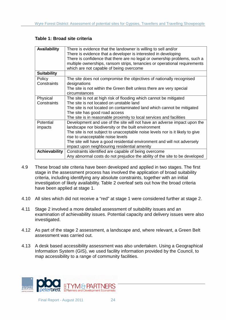
Table 1: Broad site criteria
Availability There is evidence that the landowner is willing to sell and/or There is evidence that a developer is interested in developing There is confidence that there are no legal or ownership problems, such a multiple ownerships, ransom strips, tenancies or operational requirements which are not capable of being overcome
Suitability Policy Constraints
The site does not compromise the objectives of nationally recognised designations The site is not within the Green Belt unless there are very special circumstances
Physical Constraints
The site is not at high risk of flooding which cannot be mitigated The site is not located on unstable land The site is not located on contaminated land which cannot be mitigated The site has good road access The site is in reasonable proximity to local services and facilities
Potential impacts
Development and use of the site will not have an adverse impact upon the landscape nor biodiversity or the built environment The site is not subject to unacceptable noise levels nor is it likely to give rise to unacceptable noise levels The site will have a good residential environment and will not adversely impact upon neighbouring residential amenity
Achievability
Constraints identified are capable of being overcome Any abnormal costs do not prejudice the ability of the site to be developed
4.9 These broad site criteria have been developed and applied in two stages. The first
stage in the assessment process has involved the application of broad suitability criteria, including identifying any absolute constraints, together with an initial investigation of likely availability. Table 2 overleaf sets out how the broad criteria have been applied at stage 1.
4.10 All sites which did not receive a “red” at stage 1 were considered further at stage 2. 4.11 Stage 2 involved a more detailed assessment of suitability issues and an
examination of achievability issues. Potential capacity and delivery issues were also investigated.
4.12 As part of the stage 2 assessment, a landscape and, where relevant, a Green Belt
assessment was carried out. 4.13 A desk based accessibility assessment was also undertaken. Using a Geographical
Information System (GIS), we used facility information provided by the Council, to map accessibility to a range of community facilities.
Wyre Forest District: Assessment of potential sites for Gypsies, Travellers and Travelling Showpeople
Final Report - August 2011 25
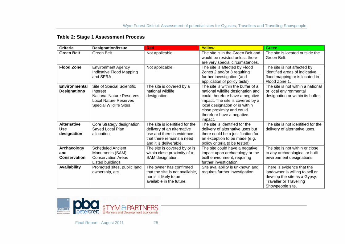
Table 2: Stage 1 Assessment Process Criteria Designation/Issue Red Yellow Green Green Belt Green Belt Not applicable. The site is in the Green Belt and
would be resisted unless there are very special circumstances.
The site is located outside the Green Belt.
Flood Zone Environment Agency Indicative Flood Mapping and SFRA
Not applicable. The site is affected by Flood Zones 2 and/or 3 requiring further investigation (and application of policy tests)
The site is not affected by identified areas of indicative flood mapping or is located in Flood Zone 1.
Environmental Designations
Site of Special Scientific Interest National Nature Reserves Local Nature Reserves Special Wildlife Sites
The site is covered by a national wildlife designation.
The site is within the buffer of a national wildlife designation and could therefore have a negative impact. The site is covered by a local designation or is within close proximity and could therefore have a negative impact.
The site is not within a national or local environmental designation or within its buffer.
Alternative Use designation
Core Strategy designation Saved Local Plan allocation
The site is identified for the delivery of an alternative use and there is evidence that there remains a need and it is deliverable.
The site is identified for the delivery of alternative uses but there could be a justification for an exception to be made (e.g. policy criteria to be tested).
The site is not identified for the delivery of alternative uses.
Archaeology and Conservation
Scheduled Ancient Monuments (SAM) Conservation Areas Listed buildings
The site is covered by or is within close proximity of a SAM designation.
The site could have a negative impact upon archaeology or the built environment, requiring further investigation.
The site is not within or close to any archaeological or built environment designations.
Availability Promoted sites, public land ownership, etc.
The owner has confirmed that the site is not available, nor is it likely to be available in the future.
Site availability is unknown and requires further investigation.
There is evidence that the landowner is willing to sell or develop the site as a Gypsy, Traveller or Travelling Showpeople site.
Wyre Forest District: Assessment of potential sites for Gypsies, Travellers and Travelling Showpeople
Final Report - August 2011 26
5 Site Assessment Long list of sites 5.1 Potential sites for site assessment were established from a review of information
relating to:
• Existing unauthorised sites and sites subject to temporary/personal permission
Sites that are currently meeting the needs of Gypsies and Travellers but do not have full planning permission.
• Expansion of existing sites Land adjacent to existing sites that could have potential to extend existing
sites. • Caravan parks
We consulted owners of existing caravan parks to explore the potential for provision for Gypsy and Traveller pitches.
• Public sector land Discussions were held with County Council and District Council officers to
establish potential council owned land for survey. • Available land for housing Land put forward for consideration for future allocation for housing as part of
the Strategic Housing Land Availability Assessment was considered. Where possible we contacted owners to identify whether they would be interested in making this land available for Gypsy, Traveller and Travelling Showpeople purposes.
• Land identified through consultation We consulted large landowners, housing associations and land agents to
identify whether any sites could be potentially available for Gypsy, Traveller or Travelling Showpeople uses.
• Housing allocations We investigated the scope for identifying land within potential housing
allocations to meet the objective of achieving mixed and balanced communities.
5.2 This process resulted in a long list of 86 potential sites. A District wide map is
contained in Appendix 1 showing the distribution of sites subject to assessment.
Wyre Forest District: Assessment of potential sites for Gypsies, Travellers and Travelling Showpeople
Final Report - August 2011 27
Stage 1 Suitability and Availability Matrix 5.3 The first stage in the assessment process involved the application of broad
suitability criteria, including absolute constraints, together with an initial investigation of likely availability.
5.4 The application of broad suitability criteria was to sieve out immediately sites which
were likely to fail on the grounds of contravening major constraints such as being within international environmental designations or within the boundaries of scheduled ancient monuments, etc.
5.5 Availability has been identified through this Assessment as a key criterion. This is
partly because of the controversial nature of provision for the Gypsy community and the probable reluctance of site owners to consider such uses in the light of local opposition. It is mainly, however, due to the fact that if a site is suitable for use by the Gypsy community, there is also likely to be landowner expectations for general housing use, which holds a significantly higher land value. It is therefore important, given the emphasis of the new spatial planning system on being able to demonstrate site deliverability, that availability is given particular consideration.
5.6 The initial assessment of site suitability and availability is summarised in a matrix,
which is set out in Appendix 2. We have used a traffic light approach, identifying where sites do not satisfy criteria in red, where criteria may be capable of being satisfied in amber and where criteria are satisfied in green.
5.7 All sites where at least one criterion is not satisfied were rejected. Sites that we
have rejected because they are not currently available, but otherwise satisfy the Stage 1 suitability criteria, could come forward for Stage 2 assessment in the future should the Council confirm their availability at a future date.
5.8 This Stage 1 assessment resulted in a list of 64 potential sites to be investigated
further at Stage 2.
Stage 2 Site Assessment 5.9 Stage 2 involved a more detailed assessment of suitability and an examination of
achievability issues. A further examination of availability was also undertaken at this stage.
5.10 Further investigations of suitability centred upon:
• physical constraints including access to the site and accessibility to existing services and facilities;
Wyre Forest District: Assessment of potential sites for Gypsies, Travellers and Travelling Showpeople
Final Report - August 2011 28
• potential impacts including landscape impact and impact upon the Green Belt (if relevant)
5.11 An accessibility assessment was undertaken looking at the proximity of the site to
key local services and facilities, particularly primary school, GP, food shop and bus stop. Sites relatively further away from these facilities have been identified as being within less sustainable locations.
5.12 All sites were visited by a landscape architect who assessed the landscape impact
of any development having regard to landscape character, sensitivity and visual containment. All sites which were considered likely to have an unacceptable impact upon the landscape were rejected.
5.13 Gypsy and Traveller and Travelling Showpeople sites should not be located within
the Green Belt except in very special circumstances. The lack of sufficient sites outside of the Green Belt to meet needs can amount to very special circumstances. Therefore an assessment was made as to the extent to which development of the sites would be harmful to the purposes and objectives of Green Belt policy.
5.14 All issues of potential achievability identified were subject to investigations where
possible, with recommendations on how they can be addressed. 5.15 Appendix 3 sets out those sites which were rejected at this stage. Sites which have
been rejected solely due to lack of availability as identified by current landowners, should be reassessed in the future should their availability be confirmed at a future date.
5.16 A total of 5 sites are identified as potentially suitable sites for Gypsies and
Travellers. However, these sites should not be viewed in isolation or seen as a definitive shortlist until the other sites identified below as "sites worthy of further consideration" are investigated more fully.
Table 3: Shortlisted sites for Gypsies and Travellers
Site Ref Site Name Settlement
CLO0001 Yard south of A456 Clows Top FAIR0001 Land off Lowe Lane Fairfield STO0006 Land off Wilden Top Road Wilden STO0019 The Gables Yard Stourport-on-Severn UUBE Open land north of Sutton Park Rise Kidderminster
Wyre Forest District: Assessment of potential sites for Gypsies, Travellers and Travelling Showpeople
Final Report - August 2011 29
5.17 One of these sites is also identified as suitable for Travelling Showpeople.
Table 4: Shortlisted site for Travelling Showpeople
Site Ref Site Name Settlement
CLO0001 Yard south of A456 Clows Top
5.18 A total of 10 further sites are identified as having potential constraints, but are considered worthy of further investigation for future Gypsy and Traveller or Travelling Showpeople provision.
5.19 Site BLA0001 could accommodate a Gypsy and Traveller site as part of a mixed
use redevelopment if affordable housing were not to be progressed. Site STO0018 is identified as lying within an area at risk of flooding where it may be appropriate for development if there are no reasonably available sites in areas with a lower probability of flooding. Site STO0004 lies within an area at serious risk of flooding but is partly an existing tolerated site and therefore the on going status of the site needs to be further considered.
Table 5: Sites worthy of further investigation (outside Green Belt)
Site Ref Site Name Settlement
BLA0001 Former Blakedown Nurseries Blakedown STO0018 Saiwen Stourport-on-Severn STO0004 Land adjacent Nunn’s Corner Stourport-on-Severn
5.20 A total of 7 sites located within the Green Belt are also considered worthy of further
investigation in the event that relatively more suitable sites outside the Green Belt cannot be delivered. It must be noted that like other sites for further investigation these sites have additional constraints which would need to be overcome. However, this does not preclude these sites being potentially suitable should policy and site specific issues be addressed.
Table 6: Sites worthy of further investigation (inside Green Belt)
Site Ref Site Name Settlement
BEW0001 Land north of Habberley Road Bewdley BEW0002 Site at Stourport Road Bewdley COOK0002 Land at Lawnswood Cookley GJAL Former school site Kidderminster KID0011 Lea Castle hospital site Kidderminster
Wyre Forest District: Assessment of potential sites for Gypsies, Travellers and Travelling Showpeople
Final Report - August 2011 30
STON0001 Former depot Stone WR104458 Redundant farm, St. John’s Road Stourport-on-Severn
5.21 Details of all of these sites are set out in Appendix 4.
Wyre Forest District: Assessment of potential sites for Gypsies, Travellers and Travelling Showpeople
Final Report - August 2011 31
6 Capacity 6.1 In section 5 we identify a list of sites which we believe are potentially suitable for
additional Gypsy and Traveller pitches or Travelling Showpeople plots. 6.2 All potentially suitable sites have been subject to an initial broad assessment of the
number of pitches or plots which could be provided on site. 6.3 This has taken account, firstly, of:
• Designing Gypsy and Traveller Sites: Good Practice Guide (CLG, 2008); • Travelling Showpeople’s Sites Model Standard Package (The Showmen’s
Guild of Great Britain, 2007) • Any relevant planning history and existing unauthorised uses; and • Templates developed for the Assessment
6.4 In addition, Baker Associates has developed templates for various forms of Gypsy and Traveller development, including for residential and transit sites. We have used these to inform the theoretical capacity of sites. Examples of these templates are set out in Appendix 5.
6.5 These have helped to determine the optimum size and configuration of pitches (or
plots) on site. On larger sites we may assume a mix of pitch sizes to reflect the needs of different families.
6.6 Site capacity has also taken account of on-site constraints and the need, where
appropriate, for landscaping and other mitigation measures to achieve a suitable development. A generous approach to landscaping and access arrangements has been taken to ensure a high standard of design can be achieved on site. This will result in sufficient access and accommodation space to create a site which Gypsy, Traveller or Travelling Showpeople find attractive. At the same time, sufficient space and landscaping will help to conserve the residential amenity of neighbouring uses.
6.7 Both the shortlisted sites and the sites considered worthy of further investigation
have been assessed for their potential capacity. The results are set out in Appendix 4.
Wyre Forest District: Assessment of potential sites for Gypsies, Travellers and Travelling Showpeople
Final Report - August 2011 32
7 Policy and delivery issues 7.1 The Wyre Forest Core Strategy and supporting evidence base identifies a number
of important requirements for the proposed Site Allocations and Policies DPD in relation to providing accommodation for Gypsies, Travellers and Travelling Showpeople. These include:
• Safeguarding existing authorised sites unless they are no longer required • Considering the suitability and sustainability of the local authority and
private sites at Sandy Lane and identifying additional pitches if appropriate • Allocating sufficient sites to meet the need for 30 additional pitches over the
next five years • Giving preference to potential sites within the existing settlement
boundaries on previously developed land • Allocating sustainable and good quality sites within and around the
settlement areas of Stourport on Severn and Kidderminster • Considering the split between the level of public and private provision • Managing a phased release of sites to control the location and scale of new
development in line with the Development Strategy. 7.2 The Core Strategy Monitoring and Implementation Framework sets out further
requirements to be addressed by the Site Allocations and Policies DPD. These include:
• Bringing forward fresh allocations if less than 16 pitches are provided by
2016 • Reviewing site allocations if an increasing trend of unauthorised and illegal
encampments is apparent by 2016 • Delivering sites through grant funding and the development control process • Co-ordinating delivery agencies (the District Council, County Council and
central Government) • In house monitoring
7.3 This section sets out some initial recommendations on how the site assessment
conclusions referred to in previous sections could be taken forward through the Site Allocations and Policies DPD to ensure that the policy framework set out in the Core Strategy relating to Gypsies, Travellers and Travelling Showpeople can be delivered.
Safeguarding existing sites 7.4 The existing authorised Gypsy sites at Sandy Lane, Stourport on Severn include:

Wyre Forest District: Assessment of potential sites for Gypsies, Travellers and Travelling Showpeople
Final Report - August 2011 33
• Lower Heath Caravan Site, Watery Lane • Broach Road Caravan Site, Sandy Lane • Meadow Caravan Park, Sandy Lane
7.5 From site survey it is clear that these sites are currently in use and are occupied.
There is evidence of overcrowding on some pitches. From interviews with resident Gypsies it is clear that the sites are valued and there is a strong preference for sites to be located within this area. There appear to be no reasons on the grounds of need why these sites should not be safeguarded for Gypsy and Traveller residential uses.
Sites at Sandy Lane, Stourport on Severn 7.6 We have investigated whether it is appropriate and possible to extend existing
authorised sites at Sandy Lane, Stourport on Severn and whether there are additional sites in the area which should be considered for allocation.
7.7 There is an existing established Gypsy community living within the Sandy Lane area
and evidence of continuing need for future provision arising from families residing in this area. The general location around the settlement of Stourport on Severn is considered to be a sustainable location as set out in Core Strategy policy CP06.
7.8 There are two major constraints within the area. 7.9 Firstly, the area is at risk of flooding and existing and potential future sites are
located either within flood zones 2 or 3. New sites located within flood zone 2 may be appropriate for highly vulnerable uses, such as caravans, mobile homes and park homes if there are no reasonably available sites in areas with a lower probability of flooding. Sites located within flood zone 3 are at serious risk of flooding and development for highly vulnerable uses should not be permitted.
7.10 Secondly, Sandy Lane is an existing employment area and Core Strategy policy
CP08 states that development which would result in a loss of employment land would only be acceptable where the site has been identified in an up-to-date Employment Land Review as being suitable for alternative uses, the site is unviable for employment uses and the proposed new use would be compatible with neighbouring uses. In such circumstances, preference will be given to mixed-use development.
7.11 The Council undertook an Employment Land Review in 2007-8 which concluded
that Sandy Lane constituted one of the best existing employment areas. No sites were considered for release from employment uses and Sandy Lane was recommended to be retained for employment uses.
Wyre Forest District: Assessment of potential sites for Gypsies, Travellers and Travelling Showpeople
Final Report - August 2011 34
7.12 Our conclusions are that there are no realistic or suitable opportunities to extend or
intensify existing authorised sites within the Sandy Lane area. 7.13 We have identified one existing residential caravan site as appropriate for allocation
for Gypsies and Travellers (The Gables Yard) and one unauthorised site (Saiwen) which is worthy of further investigation should there be no reasonably available sites in other areas with a lower probability of flooding. Another site, (land adjacent Nunn’s Corner) lies within an area at serious risk of flooding but is partly an existing tolerated site and therefore the on going status of the site is worthy of further investigation. These sites are existing Gypsy sites which have been occupied prior to the adoption of the Core Strategy in December 2010. Consideration of these sites for permanent use would not prejudice the employment policy now operating within the Sandy Lane area.
7.14 We have rejected other sites in the vicinity for site allocation, although it is always
open to potential applicants on individual sites to demonstrate acceptability in flood risk terms through undertaking flood risk assessments and to demonstrate how the provisions of policy CP08 relating to loss of employment land could be satisfied.
Sustainable locations 7.15 A key requirement of the Core Strategy is that Gypsy, Traveller and Travelling
Showpeople sites are allocated within and around the settlement areas of Stourport on Severn and Kidderminster and that preference is given to potential sites within the existing settlement boundaries on previously developed sites.
7.16 In addition, Core Strategy policy CP06 states that local community facilities should
be within easy access from sites by a variety of modes of transport. 7.17 The following table summarises the extent to which the shortlisted sites and sites
worthy of further investigation satisfy the criteria in the Core Strategy. This will help the Council to determine which sites may be the most suitable for allocation in the Site Allocations and Policies DPD.
Wyre Forest District: Assessment of potential sites for Gypsies, Travellers and Travelling Showpeople
Final Report - August 2011 35
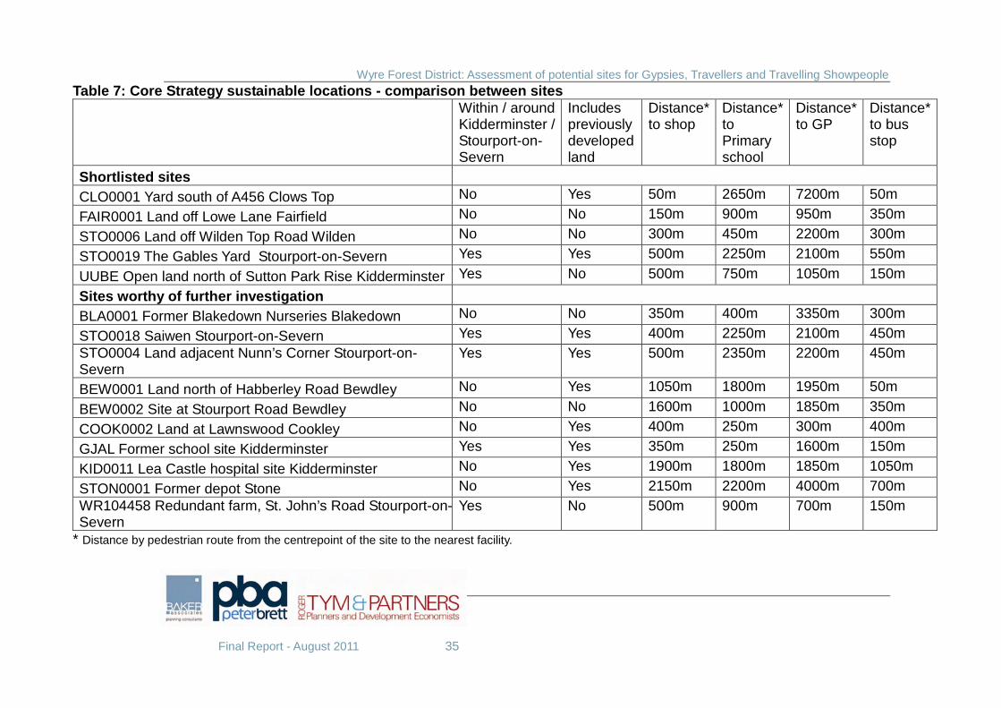
Table 7: Core Strategy sustainable locations - comparison between sites
Within / around Kidderminster / Stourport-on-Severn
Includes previously developed land
Distance* to shop
Distance* to Primary school
Distance* to GP
Distance* to bus stop
Shortlisted sites
CLO0001 Yard south of A456 Clows Top No Yes 50m 2650m 7200m 50m
FAIR0001 Land off Lowe Lane Fairfield No No 150m 900m 950m 350m
STO0006 Land off Wilden Top Road Wilden No No 300m 450m 2200m 300m
STO0019 The Gables Yard Stourport-on-Severn Yes Yes 500m 2250m 2100m 550m
UUBE Open land north of Sutton Park Rise Kidderminster Yes No 500m 750m 1050m 150m
Sites worthy of further investigation
BLA0001 Former Blakedown Nurseries Blakedown No No 350m 400m 3350m 300m
STO0018 Saiwen Stourport-on-Severn Yes Yes 400m 2250m 2100m 450m STO0004 Land adjacent Nunn’s Corner Stourport-on-Severn
Yes Yes 500m 2350m 2200m 450m
BEW0001 Land north of Habberley Road Bewdley No Yes 1050m 1800m 1950m 50m
BEW0002 Site at Stourport Road Bewdley No No 1600m 1000m 1850m 350m
COOK0002 Land at Lawnswood Cookley No Yes 400m 250m 300m 400m
GJAL Former school site Kidderminster Yes Yes 350m 250m 1600m 150m
KID0011 Lea Castle hospital site Kidderminster No Yes 1900m 1800m 1850m 1050m
STON0001 Former depot Stone No Yes 2150m 2200m 4000m 700m WR104458 Redundant farm, St. John’s Road Stourport-on-Severn
Yes No 500m 900m 700m 150m
* Distance by pedestrian route from the centrepoint of the site to the nearest facility.
Wyre Forest District: Assessment of potential sites for Gypsies, Travellers and Travelling Showpeople
Final Report - August 2011 36
Allocating sites to meet 5 year needs
7.18 Policy CP06 of the Core Strategy identifies a need to provide for 30 additional pitches over the next 5 years. In addition, emerging Government policy is looking for local authorities to plan for a continuous 5 year supply of pitches.
7.19 7 pitches have already received planning permission since 2008. Therefore, the net
additional requirement to meet the GTAA figure is 23 pitches to be identified by 2013. Subsequently, there will be a need to reassess needs for periods up to 2026 and to make provision to meet those needs.
7.20 There is a particular issue around existing sites which are currently unauthorised
but tolerated. Technically, if these sites are allocated and planning permission granted, they count towards the additional requirement, even though they are existing sites. The calculations set out below take this approach.
7.21 The shortlisted sites have been assessed for their deliverability over 5, 10 and 15
year periods, from the likely date of adoption of the Site Allocations and Policies DPD in 2013. Clearly, there is an immediate need and therefore delivery of sites needs to be frontloaded to ensure that there is an early supply of sites. Some sites are deliverable now and progression through the planning system could be considered before formal adoption of the Site Allocations and Policies DPD in 2013.
7.22 From our assessment, the five shortlisted sites have a potential to deliver 39 pitches
by 2018, although this would be reduced to 24 pitches, if the site at Clows Top were to be developed for Travelling Showpeople.
7.23 Should the Council consider any of the shortlisted sites to be inappropriate or
undeliverable we have identified a series of other sites which have constraints but which may be worthy of further investigation. Some of these sites could supplement or replace shortlisted sites in the short term. These could include those existing unauthorised sites where provision could be relatively quickly and easily delivered.
Meeting longer term needs to 2026 7.24 A further 10 pitches could be delivered from one of the shortlisted sites in the
medium term, by 2023. This provision is associated with neighbouring residential development and therefore a longer term provision has been assumed because of the need to manage a more substantial change to settlement edges.
7.25 Should future studies of Gypsy, Traveller and Travelling Showpeople needs identify
a need for additional pitches, or should shortlisted sites not be considered to be appropriate for or capable of development, there may be a need to consider other sites for release.
Wyre Forest District: Assessment of potential sites for Gypsies, Travellers and Travelling Showpeople
Final Report - August 2011 37
7.26 Most of the sites considered worthy of further investigation are located within the
Green Belt. The Council will need to consider whether long term needs and the lack of identified sites to meet longer term needs could justify the removal of land from within the Green Belt.
7.27 We do not consider that all of the sites identified within the Green Belt should come
forward. However, the Council has already identified some large brownfield sites within the Green Belt as needing to be subject to redevelopment and mixed use redevelopment with an element of Gypsy and Traveller provision could form the basis for longer term delivery of sites.
Phasing, monitoring and review 7.28 As with other forms of development, the release of Gypsy, Traveller and Travelling
Showpeople sites should be managed to ensure a good fit with identified need. 7.29 The Core Strategy Monitoring and Implementation Framework identifies a need for
the Council to actively monitor needs and provision and to bring forward fresh allocations if less than 16 pitches are provided by 2016 or if an increasing trend of unauthorised and illegal encampments is apparent by 2016.
7.30 We would suggest that it would be prudent for the Council to identify a potential
reserve of land as part of the development of the Site Allocations and Policies DPD which could be brought forward in the future if required, rather than wait for the need to be established and then start a review of the development plan at that time.
7.31 The list of sites considered worthy of further investigation contains a range of sites
which could be considered for future release if required. 7.32 Any release of land to meet future needs would require active monitoring of supply
against need. It would particularly require the Council to undertake periodic reviews of its needs evidence base. The South Housing Market Gypsy and Traveller Accommodation Assessment was published in 2008 and only quantifies needs for a 5 year period. Similarly, the Core Strategy only identifies pitch requirements for the first 5 years of the plan. Periodic reviews of needs are therefore desirable.
Public and private provision 7.33 The Core Strategy reports the conclusions of the South Housing Market Gypsy and
Traveller Accommodation Assessment that the majority of provision should be local authority or Registered Social Landlord sites unless smaller private sites can be identified.
Wyre Forest District: Assessment of potential sites for Gypsies, Travellers and Travelling Showpeople
Final Report - August 2011 38
7.34 The preference of the Gypsy and Traveller communities is for small, private sites. However, many Gypsies and Travellers are not in a position to be able to afford to buy their own sites or to pay market rents and there will continue to be a need for some sites to be available at affordable rents. This is likely to require public provision, although there are alternative delivery models (see below).
7.35 Our shortlist of sites include a range of sites which could be delivered for either
private or public provision. We believe, given the scale of needs identified and the level of overcrowding at the existing local authority sites that at least one new public site of up to 15 pitches will be needed to meet current identified needs.
7.36 Two of the shortlisted sites are currently owned by either the District or County
Councils.
Delivery plan 7.37 In view of the need for additional pitches, there must be reasonable certainty that
the sites identified in the DPD will be implemented i.e. that they are genuinely deliverable. Deliverability will be a key aspect of the site assessment process.
7.38 A number of potential delivery options have been developed which the Council
should investigate further during the preparation of the Site Allocations and Policies DPD.
Delivery option 1
7.39 Firstly, there may be sites which are currently owned by individual Gypsy, Traveller and Travelling Showpeople families which can be developed to meet immediate family requirements. In this case, allocation in a DPD would provide the planning policy context for early progression of a planning application and for development to take place or for currently unauthorised development to become authorised.
Delivery option 2
7.40 Secondly, there may be sites which are currently owned by individual Gypsy, Traveller and Travelling Showpeople families where there is capacity for greater use of the site for further pitches. In this case, initial discussions will be undertaken with the owners to identify whether there are likely to be future family or extended family needs requiring the allocation of the site for a greater number of pitches than is currently required. In this case, allocation in the DPD with a phasing programme to secure provision for future need would be the appropriate way forward.
Wyre Forest District: Assessment of potential sites for Gypsies, Travellers and Travelling Showpeople
Final Report - August 2011 39
Delivery option 3 7.41 Thirdly, there may be sites which are not currently owned by Gypsy, Traveller and
Travelling families but which have potential to be developed for such uses. Allocation in the DPD would identify these sites to travelling communities and they could be purchased on the open market. Alternatively the Councils could consider using Homes Bonus or other monies to buy the site or identify their own public assets and then make them available to organised Gypsy and Traveller groups on a non-profit making basis for them to develop and manage. Such groups could also be offered the opportunity to buy stakes in the site, allowing the income from such sales to provide further sites. There are emerging examples of innovative acquisition and funding arrangements across the country.
Delivery option 4
7.42 Fourthly, there may be sites where the Councils consider that additional affordable
pitch provision may be appropriate. In this case, the Councils should investigate the potential for either buying sites or developing their public assets using Homes Bonus or central Government site grant funding or other monies to secure or increase affordable provision. Sites could then either be managed by a Council or a Registered Social Landlord.
Delivery option 5
7.43 Finally, if the Council decides to pursue the longer term option of seeking Gypsy
and Traveller provision on large housing urban extension sites, there is the opportunity to require large housing allocations in Core Strategies and/or subsequent allocations DPDs to provide for Gypsy and Traveller pitches. These could then be sold on the open market or affordable pitches brought forward and managed by the Councils or RSLs.
7.44 All the shortlisted sites and sites worthy of further investigation have been subject to
an initial broad assessment of the potential delivery option(s) which may be appropriate. Appendices 4 and 5 include our conclusions on potential delivery models. Potential delivery solutions should be investigated further through the DPD process with landowners and other stakeholders to ensure that sites identified in the submission DPD are capable of being developed during the plan period.
Funding sources
7.45 The current Government has identified that it is focusing on incentivising Councils
to deliver new housing, including Traveller sites. The 2011 consultation on “Planning
Wyre Forest District: Assessment of potential sites for Gypsies, Travellers and Travelling Showpeople
Final Report - August 2011 40
for traveller sites”11 identifies three potential sources of funding for local authorities. 7.46 Firstly, the New Homes Bonus scheme will operate in the same way for Traveller
sites as for other forms of housing. Namely, for every new pitch, a local planning authority should get six years of matched Council Tax funding, with an extra supplement for affordable pitches (such as sites owned or managed by local authorities).
7.47 Secondly, the Government has allocated, as part of its National Affordable Housing
Programme for 2011-15. £60m to fund the provision of Traveller sites. Local authorities will be required to bid for this funding.
7.48 Thirdly, the introduction of the Community Infrastructure Levy provides a further
potential funding source for enabling works required to deliver Council priorities. 7.49 As delivery model 3 above illustrates, there are innovative delivery models being
developed in other parts of the country which can provide for funding of initial sites to be recycled to provide for further sites, in the same way as affordable housing and shared equity schemes have been delivered by housing bodies for some years.
7.50 The Council should investigate these sources of funding further, in partnership with
the County Council, Registered Social Landlords and other delivery partners. 11 Communities and Local Government (2011) Planning for traveller sites
Wyre Forest District: Assessment of potential sites for Gypsies, Travellers and Travelling Showpeople
Final Report - August 2011 41
8 Recommendations Safeguarding existing sites 8.1 The existing authorised Gypsy sites at Sandy Lane, Stourport on Severn include:
• Lower Heath Caravan Site, Watery Lane • Broach Road Caravan Site, Sandy Lane • Meadow Caravan Park, Sandy Lane
8.2 From site survey it is clear that these sites are currently in use and are occupied.
There is evidence of overcrowding on some pitches. From interviews with resident Gypsies it is clear that the sites are valued and there is a strong preference for sites to be located within this area. There appear to be no reasons on the grounds of need why these sites should not be safeguarded for Gypsy and Traveller residential uses.
Sites for allocation
8.3 Chapter 5 identifies a total of 5 shortlisted sites as potentially suitable sites for
Gypsies and Travellers to meet identified current and future needs in the short to medium period. Some of these sites are available now. One of these sites is potentially suitable for Travelling Showpeople provision.
8.4 A total of 10 further sites are identified as having potential constraints, but are
considered worthy of further investigation for Gypsy, Traveller and/or Travelling Showpeople either to supplement or replace shortlisted sites in the short to medium term and to provide for long term needs, if required.
8.5 7 of these sites are located within the Green Belt and could be considered in the
event that relatively more suitable sites outside the Green Belt cannot be delivered. It must be noted that like other sites for further investigation these sites have additional constraints which would need to be overcome. However, this does not preclude these sites being potentially suitable should policy and site specific issues be addressed.
8.6 The following table sets out all of the shortlisted sites and sites worthy of further
investigation. It is recommended that the Council consults further on these potential sites as part of the development of the Site Allocations and Policies DPD.
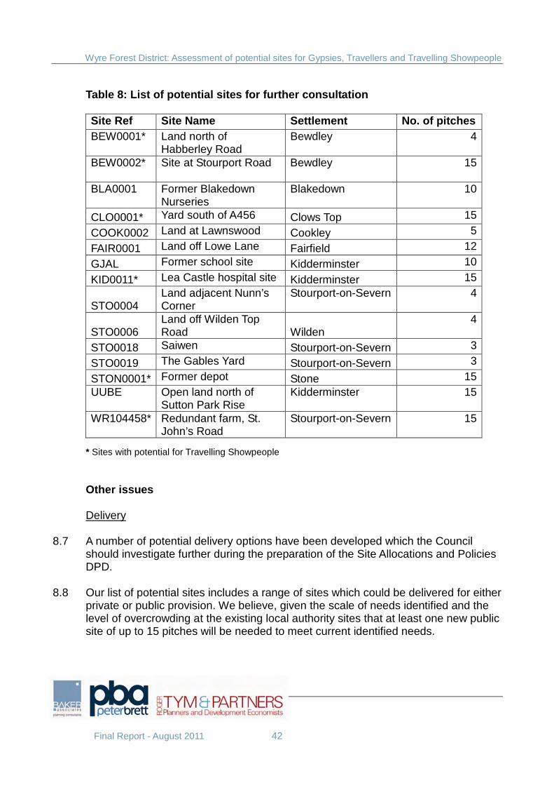
Wyre Forest District: Assessment of potential sites for Gypsies, Travellers and Travelling Showpeople
Final Report - August 2011 42
Table 8: List of potential sites for further consultation
Site Ref Site Name Settlement No. of pitches BEW0001*
Land north of Habberley Road
Bewdley
4
BEW0002*
Site at Stourport Road Bewdley
15
BLA0001
Former Blakedown Nurseries
Blakedown
10
CLO0001* Yard south of A456 Clows Top 15
COOK0002 Land at Lawnswood Cookley 5
FAIR0001 Land off Lowe Lane Fairfield 12
GJAL Former school site Kidderminster 10
KID0011* Lea Castle hospital site Kidderminster 15
STO0004 Land adjacent Nunn’s Corner
Stourport-on-Severn
4
STO0006 Land off Wilden Top Road Wilden
4
STO0018 Saiwen Stourport-on-Severn 3
STO0019 The Gables Yard Stourport-on-Severn 3
STON0001* Former depot Stone 15 UUBE
Open land north of Sutton Park Rise
Kidderminster
15
WR104458*
Redundant farm, St. John’s Road
Stourport-on-Severn
15
* Sites with potential for Travelling Showpeople Other issues Delivery
8.7 A number of potential delivery options have been developed which the Council should investigate further during the preparation of the Site Allocations and Policies DPD.
8.8 Our list of potential sites includes a range of sites which could be delivered for either private or public provision. We believe, given the scale of needs identified and the level of overcrowding at the existing local authority sites that at least one new public site of up to 15 pitches will be needed to meet current identified needs.
Wyre Forest District: Assessment of potential sites for Gypsies, Travellers and Travelling Showpeople
Final Report - August 2011 43
8.9 The Council should investigate the available sources of funding further, in partnership with the County Council, Registered Social Landlords and other potential delivery partners. Phasing, monitoring and review
8.10 As with other forms of development, the release of Gypsy, Traveller and Travelling Showpeople sites should be managed to ensure a good fit with identified need.
8.11 We would suggest that it would be prudent for the Council to identify a potential
reserve of land as part of the development of the Site Allocations and Policies DPD which could be brought forward in the future if required, rather than wait for the need to be established and then start a review of the development plan at that time.
8.12 Any release of land to meet future needs would require active monitoring of supply
against need. It would particularly require the Council to undertake periodic reviews of its needs evidence base. The South Housing Market Gypsy and Traveller Accommodation Assessment was published in 2008 and only quantifies needs for a 5 year period. Similarly, the Core Strategy only identifies pitch requirements for the first 5 years of the plan. Periodic reviews of needs are therefore desirable.

Wyre Forest District: Assessment of potential sites for Gypsies, Travellers and Travelling Showpeople
Final Report - August 2011
Appendix 1: District site map
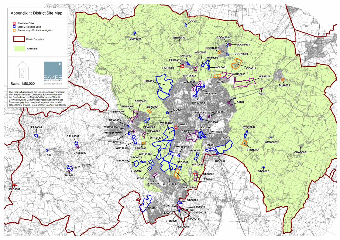

Wyre Forest District: Assessment of potential sites for Gypsies, Travellers and Travelling Showpeople
Final Report - August 2011
Appendix 2: Stage 1 Site assessment matrix
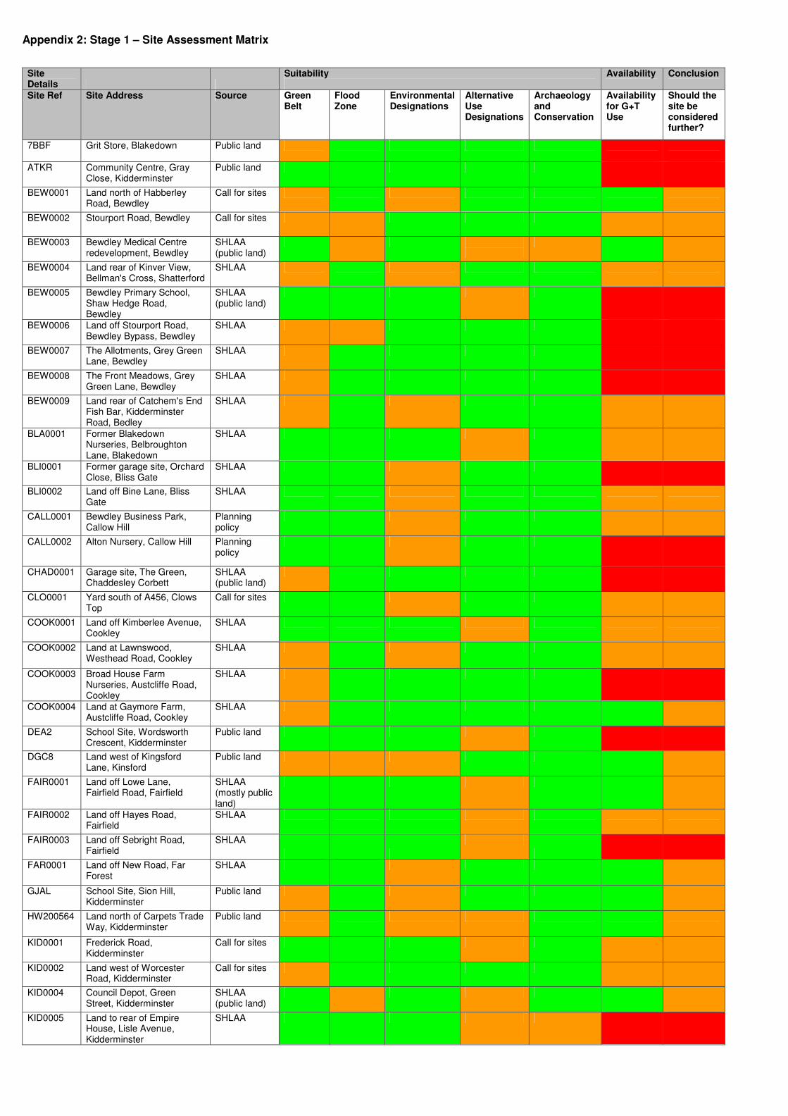
Appendix 2: Stage 1 – Site Assessment Matrix
Site Details
Suitability
Availability Conclusion
Site Ref Site Address Source Green Belt
Flood Zone
Environmental Designations
Alternative Use Designations
Archaeology and Conservation
Availability for G+T Use
Should the site be considered further?
7BBF
Grit Store, Blakedown Public land
ATKR Community Centre, Gray Close, Kidderminster
Public land
BEW0001 Land north of Habberley Road, Bewdley
Call for sites
BEW0002 Stourport Road, Bewdley Call for sites
BEW0003 Bewdley Medical Centre redevelopment, Bewdley
SHLAA (public land)
BEW0004 Land rear of Kinver View, Bellman's Cross, Shatterford
SHLAA
BEW0005 Bewdley Primary School, Shaw Hedge Road, Bewdley
SHLAA (public land)
BEW0006 Land off Stourport Road, Bewdley Bypass, Bewdley
SHLAA
BEW0007 The Allotments, Grey Green Lane, Bewdley
SHLAA
BEW0008 The Front Meadows, Grey Green Lane, Bewdley
SHLAA
BEW0009 Land rear of Catchem's End Fish Bar, Kidderminster Road, Bedley
SHLAA
BLA0001 Former Blakedown Nurseries, Belbroughton Lane, Blakedown
SHLAA
BLI0001 Former garage site, Orchard Close, Bliss Gate
SHLAA
BLI0002 Land off Bine Lane, Bliss Gate
SHLAA
CALL0001 Bewdley Business Park, Callow Hill
Planning policy
CALL0002 Alton Nursery, Callow Hill Planning policy
CHAD0001 Garage site, The Green, Chaddesley Corbett
SHLAA (public land)
CLO0001 Yard south of A456, Clows Top
Call for sites
COOK0001 Land off Kimberlee Avenue, Cookley
SHLAA
COOK0002 Land at Lawnswood, Westhead Road, Cookley
SHLAA
COOK0003 Broad House Farm Nurseries, Austcliffe Road, Cookley
SHLAA
COOK0004 Land at Gaymore Farm, Austcliffe Road, Cookley
SHLAA
DEA2 School Site, Wordsworth Crescent, Kidderminster
Public land
DGC8 Land west of Kingsford Lane, Kinsford
Public land
FAIR0001 Land off Lowe Lane, Fairfield Road, Fairfield
SHLAA (mostly public land)
FAIR0002 Land off Hayes Road, Fairfield
SHLAA
FAIR0003 Land off Sebright Road, Fairfield
SHLAA
FAR0001 Land off New Road, Far Forest
SHLAA
GJAL School Site, Sion Hill, Kidderminster
Public land
HW200564 Land north of Carpets Trade Way, Kidderminster
Public land
KID0001 Frederick Road, Kidderminster
Call for sites
KID0002 Land west of Worcester Road, Kidderminster
Call for sites
KID0004 Council Depot, Green Street, Kidderminster
SHLAA (public land)
KID0005 Land to rear of Empire House, Lisle Avenue, Kidderminster
SHLAA
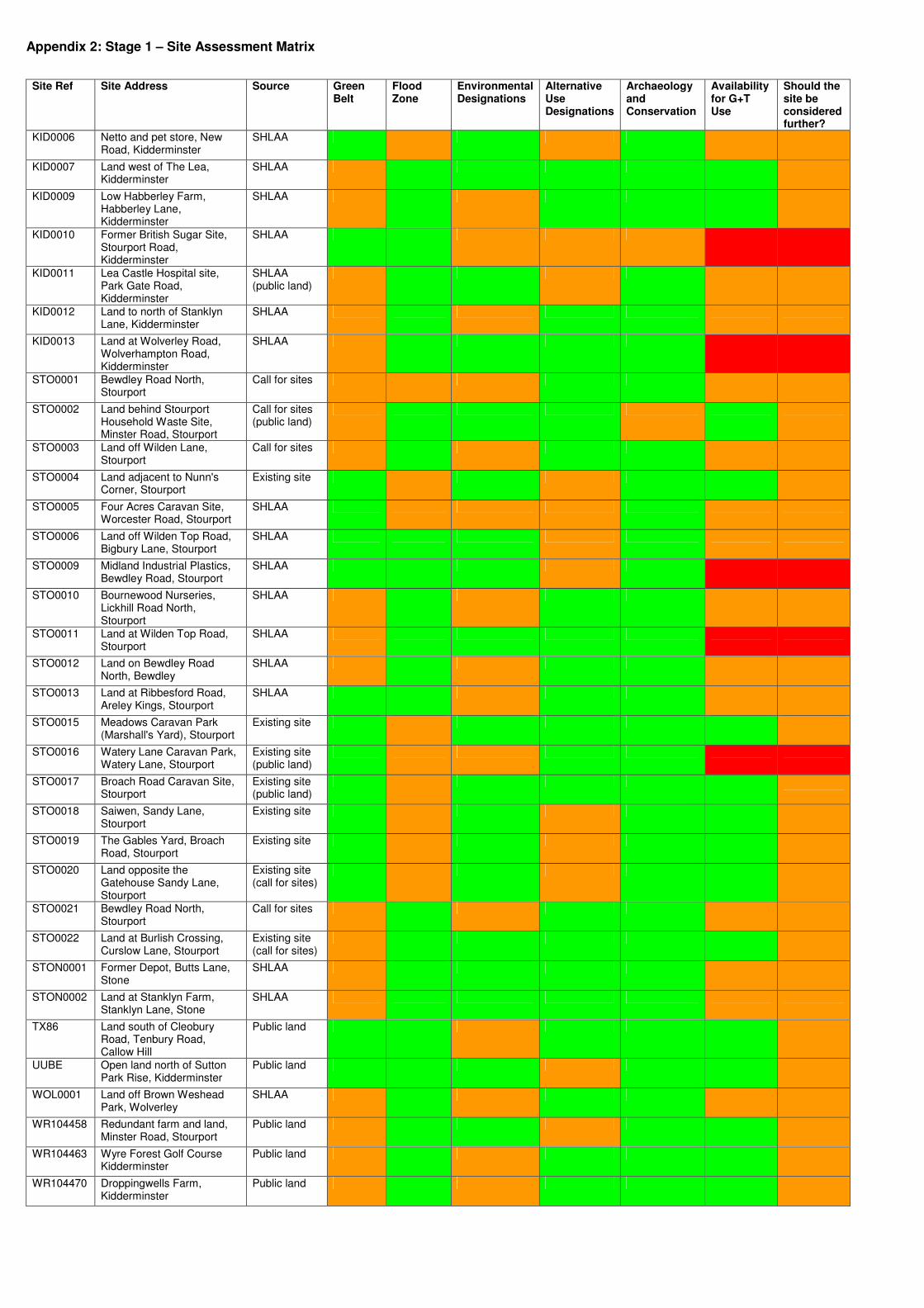
Appendix 2: Stage 1 – Site Assessment Matrix
Site Ref Site Address Source Green Belt
Flood Zone
Environmental Designations
Alternative Use Designations
Archaeology and Conservation
Availability for G+T Use
Should the site be considered further?
KID0006 Netto and pet store, New Road, Kidderminster
SHLAA
KID0007 Land west of The Lea, Kidderminster
SHLAA
KID0009 Low Habberley Farm, Habberley Lane, Kidderminster
SHLAA
KID0010 Former British Sugar Site, Stourport Road, Kidderminster
SHLAA
KID0011 Lea Castle Hospital site, Park Gate Road, Kidderminster
SHLAA (public land)
KID0012 Land to north of Stanklyn Lane, Kidderminster
SHLAA
KID0013 Land at Wolverley Road, Wolverhampton Road, Kidderminster
SHLAA
STO0001 Bewdley Road North, Stourport
Call for sites
STO0002 Land behind Stourport Household Waste Site, Minster Road, Stourport
Call for sites (public land)
STO0003 Land off Wilden Lane, Stourport
Call for sites
STO0004 Land adjacent to Nunn's Corner, Stourport
Existing site
STO0005 Four Acres Caravan Site, Worcester Road, Stourport
SHLAA
STO0006 Land off Wilden Top Road, Bigbury Lane, Stourport
SHLAA
STO0009 Midland Industrial Plastics, Bewdley Road, Stourport
SHLAA
STO0010 Bournewood Nurseries, Lickhill Road North, Stourport
SHLAA
STO0011 Land at Wilden Top Road, Stourport
SHLAA
STO0012 Land on Bewdley Road North, Bewdley
SHLAA
STO0013 Land at Ribbesford Road, Areley Kings, Stourport
SHLAA
STO0015 Meadows Caravan Park (Marshall's Yard), Stourport
Existing site
STO0016 Watery Lane Caravan Park, Watery Lane, Stourport
Existing site (public land)
STO0017 Broach Road Caravan Site, Stourport
Existing site (public land)
STO0018 Saiwen, Sandy Lane, Stourport
Existing site
STO0019 The Gables Yard, Broach Road, Stourport
Existing site
STO0020 Land opposite the Gatehouse Sandy Lane, Stourport
Existing site (call for sites)
STO0021 Bewdley Road North, Stourport
Call for sites
STO0022 Land at Burlish Crossing, Curslow Lane, Stourport
Existing site (call for sites)
STON0001 Former Depot, Butts Lane, Stone
SHLAA
STON0002 Land at Stanklyn Farm, Stanklyn Lane, Stone
SHLAA
TX86 Land south of Cleobury Road, Tenbury Road, Callow Hill
Public land
UUBE Open land north of Sutton Park Rise, Kidderminster
Public land
WOL0001 Land off Brown Weshead Park, Wolverley
SHLAA
WR104458 Redundant farm and land, Minster Road, Stourport
Public land
WR104463 Wyre Forest Golf Course Kidderminster
Public land
WR104470 Droppingwells Farm, Kidderminster
Public land
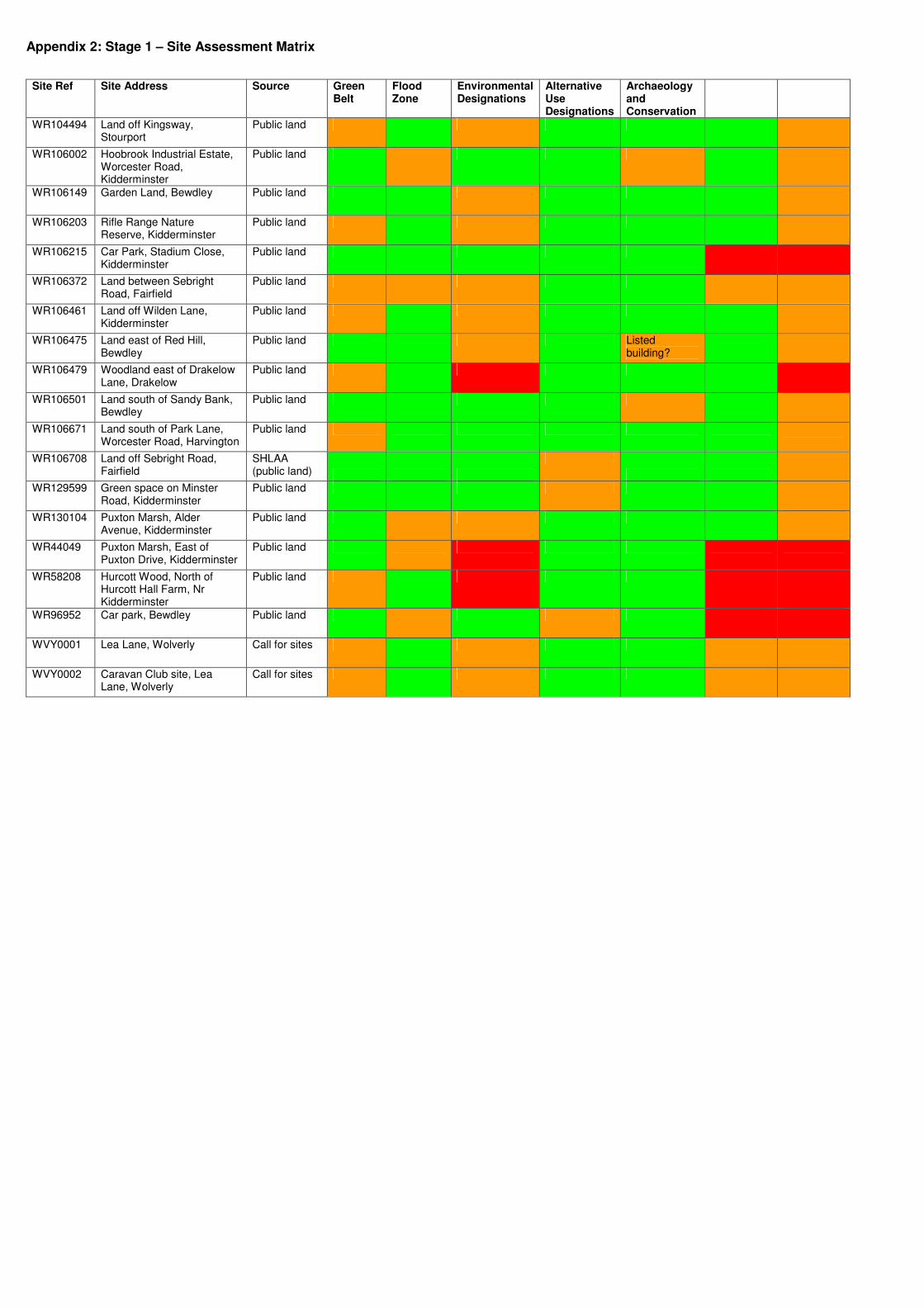
Appendix 2: Stage 1 – Site Assessment Matrix
Site Ref Site Address Source Green Belt
Flood Zone
Environmental Designations
Alternative Use Designations
Archaeology and Conservation
WR104494 Land off Kingsway, Stourport
Public land
WR106002 Hoobrook Industrial Estate, Worcester Road, Kidderminster
Public land
WR106149 Garden Land, Bewdley Public land
WR106203 Rifle Range Nature Reserve, Kidderminster
Public land
WR106215 Car Park, Stadium Close, Kidderminster
Public land
WR106372 Land between Sebright Road, Fairfield
Public land
WR106461 Land off Wilden Lane, Kidderminster
Public land
WR106475 Land east of Red Hill, Bewdley
Public land Listed building?
WR106479 Woodland east of Drakelow Lane, Drakelow
Public land
WR106501 Land south of Sandy Bank, Bewdley
Public land
WR106671 Land south of Park Lane, Worcester Road, Harvington
Public land
WR106708 Land off Sebright Road, Fairfield
SHLAA (public land)
WR129599 Green space on Minster Road, Kidderminster
Public land
WR130104 Puxton Marsh, Alder Avenue, Kidderminster
Public land
WR44049 Puxton Marsh, East of Puxton Drive, Kidderminster
Public land
WR58208 Hurcott Wood, North of Hurcott Hall Farm, Nr Kidderminster
Public land
WR96952 Car park, Bewdley Public land
WVY0001 Lea Lane, Wolverly Call for sites
WVY0002 Caravan Club site, Lea Lane, Wolverly
Call for sites

Wyre Forest District: Assessment of potential sites for Gypsies, Travellers and Travelling Showpeople
Final Report - August 2011
Appendix 3: Stage 2 Rejected sites
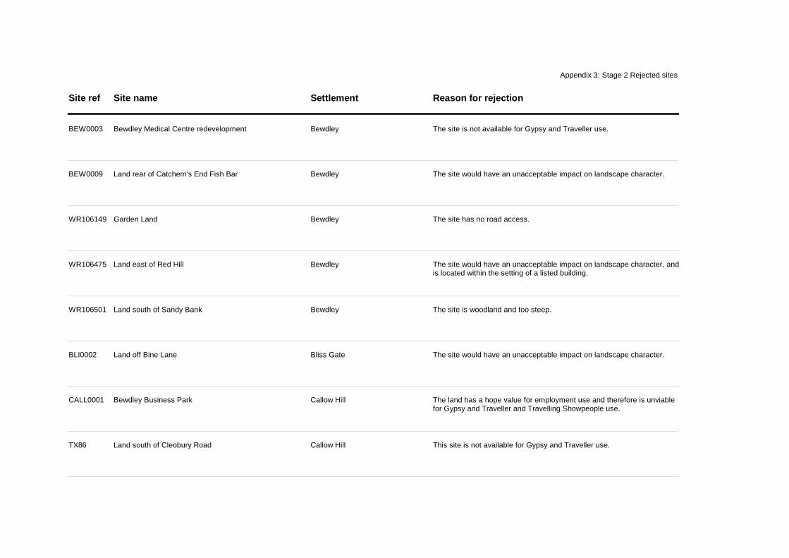
Site ref Site name Settlement Reason for rejection
Appendix 3: Stage 2 Rejected sites
BEW0003 Bewdley Medical Centre redevelopment Bewdley The site is not available for Gypsy and Traveller use.
BEW0009 Land rear of Catchem's End Fish Bar Bewdley The site would have an unacceptable impact on landscape character.
WR106149 Garden Land Bewdley The site has no road access.
WR106475 Land east of Red Hill Bewdley The site would have an unacceptable impact on landscape character, and is located within the setting of a listed building.
WR106501 Land south of Sandy Bank Bewdley The site is woodland and too steep.
BLI0002 Land off Bine Lane Bliss Gate The site would have an unacceptable impact on landscape character.
CALL0001 Bewdley Business Park Callow Hill The land has a hope value for employment use and therefore is unviable for Gypsy and Traveller and Travelling Showpeople use.
TX86 Land south of Cleobury Road Callow Hill This site is not available for Gypsy and Traveller use.
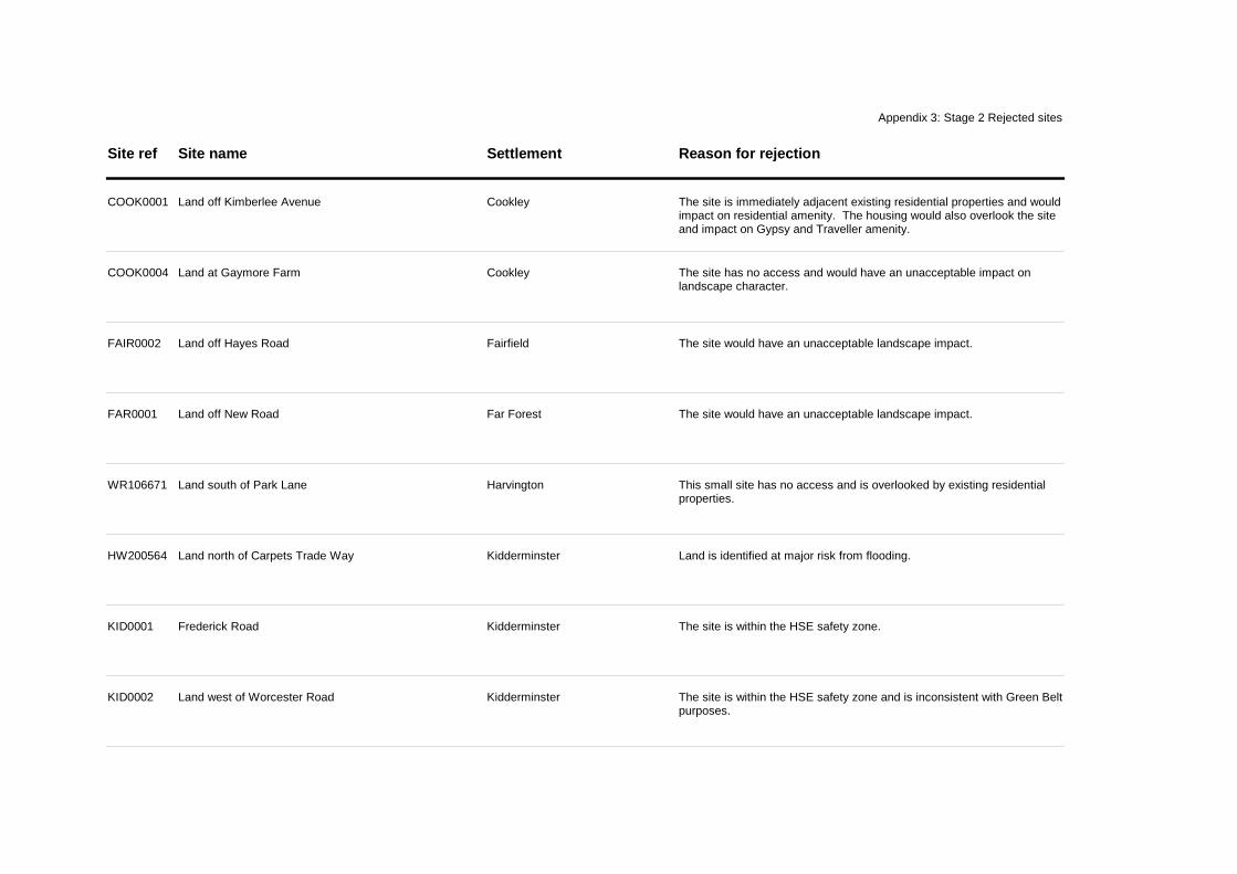
Site ref Site name Settlement Reason for rejection
Appendix 3: Stage 2 Rejected sites
COOK0001 Land off Kimberlee Avenue Cookley The site is immediately adjacent existing residential properties and would impact on residential amenity. The housing would also overlook the site and impact on Gypsy and Traveller amenity.
COOK0004 Land at Gaymore Farm Cookley The site has no access and would have an unacceptable impact on landscape character.
FAIR0002 Land off Hayes Road Fairfield The site would have an unacceptable landscape impact.
FAR0001 Land off New Road Far Forest The site would have an unacceptable landscape impact.
WR106671 Land south of Park Lane Harvington This small site has no access and is overlooked by existing residential properties.
HW200564 Land north of Carpets Trade Way Kidderminster Land is identified at major risk from flooding.
KID0001 Frederick Road Kidderminster The site is within the HSE safety zone.
KID0002 Land west of Worcester Road Kidderminster The site is within the HSE safety zone and is inconsistent with Green Belt purposes.
Site ref Site name Settlement Reason for rejection
Appendix 3: Stage 2 Rejected sites
KID0004 Council Depot Kidderminster This site is not available for Gypsy and Traveller use.
KID0006 Netto and pet store Kidderminster This site is not available for Gypsy and Traveller use.
KID0007 Land west of The Lea Kidderminster The site would have an unacceptable impact on landscape character.
KID0009 Low Habberley Farm Kidderminster Although a very small section of the site could be suitable for Gypsy and Traveller, these parts would only be available if part of a wider mixed use development on land which is currently deemed unsuitable for development.
KID0012 Land to north of Stanklyn Lane Kidderminster The site would have an unacceptable landscape impact and would be inconsistent with Green Belt purposes.
WR104463 Wyre Forest Golf Course Kidderminster The site as a whole is not likely to be available due to a long lease for golfing activities. The one area to the north west which may be available is inappropriate in terms of landscape impact and impact on the openness of the Green Belt.
WR104470 Droppingwells Farm Kidderminster The site has access issues and would have an unacceptable impact on landscape character.
Site ref Site name Settlement Reason for rejection
Appendix 3: Stage 2 Rejected sites
WR106002 Hoobrook Industrial Estate Kidderminster The site is open to views from the Conservation Area and any development would have an unacceptable impact on the historic area.
WR106203 Rifle Range Nature Reserve Kidderminster This site is a nature reserve, and the site would be inconsistent with Green Belt purposes.
WR106461 Land off Wilden Lane Kidderminster The site would have an unacceptable impact on landscape character, and would be inconsistent with Green Belt purposes.
WR129599 Green space on Minster Road Kidderminster This site is not available for Gypsy and Traveller use.
WR130104 Puxton Marsh Kidderminster The site would have an unacceptable impact on landscape character and is within the functional flood plain.
DGC8 Land west of Kingsford Lane Kingsford The site would be inconsistent with Green Belt purposes.
BEW0004 Land rear of Kinver View Shatterford The site is not available as the owner is looking for a higher value alternative use than Gypsy and Traveller use.
STON0002 Land at Stanklyn Farm Stone The site would be inconsistent with Green Belt purposes.
Site ref Site name Settlement Reason for rejection
Appendix 3: Stage 2 Rejected sites
STO0001 Bewdley Road North Stourport-on-Severn The site would be inconsistent with Green Belt purposes and would have an unacceptable landscape impact.
STO0002 Land behind Stourport Household Waste Site Stourport-on-Severn The site would be inconsistent with Green Belt purposes.
STO0003 Land off Wilden Lane Stourport-on-Severn The site would have an unacceptable impact on landscape character, and would be inconsistent with Green Belt purposes.
STO0005 Four Acres Caravan Site Stourport-on-Severn This site is not available for Gypsy and Traveller use.
STO0010 Bournewood Nurseries Stourport-on-Severn The site is not available as the owner is not interested in releasing land for Gypsy and Traveller use.
STO0012 Land on Bewdley Road North Stourport-on-Severn The site would have an unacceptable impact on landscape character and residential amenity (for any location immediately adjacent residential properties).
STO0013 Land at Ribbesford Road Stourport-on-Severn The site would have an unacceptable impact on landscape character.
STO0015 Meadows Caravan Park (Marshall's Yard) Stourport-on-Severn There is no room for further expansion or intensification of this existing site for Gypsy and Traveller use.
Site ref Site name Settlement Reason for rejection
Appendix 3: Stage 2 Rejected sites
STO0017 Broach Road Caravan Site Stourport-on-Severn There is no room for further expansion or intensification of the site for Gypsy and Traveller use.
STO0020 Land opposite the Gatehouse Stourport-on-Severn This site is subject to flooding and objections have been received from the Environment Agency.
STO0021 Bewdley Road North Stourport-on-Severn The site would have an unacceptable impact on landscape character, and would be inconsistent with Green Belt purposes.
STO0022 Land at Burlish Crossing Stourport-on-Severn The site would have an unacceptable impact on landscape character, and would be inconsistent with Green Belt purposes.
WR104494 Land off Kingsway Stourport-on-Severn The site is not available for Gypsy and Traveller use.
WOL0001 Land off Brown Westhead Park Wolverley Very overgrown scrubland. Derelict building and steep topography. Access ok. Might take quite a bit of work to bring the site forward.
WVY0001 Lea Lane Wolverley The site would be inconsistent with Green Belt purposes.
WVY0002 Lea Lane Wolverley The site is not available for Gypsy and Traveller use.
Wyre Forest District: Assessment of potential sites for Gypsies, Travellers and Travelling Showpeople
Final Report - August 2011
Appendix 4: Shortlisted sites and sites worthy of further investigation
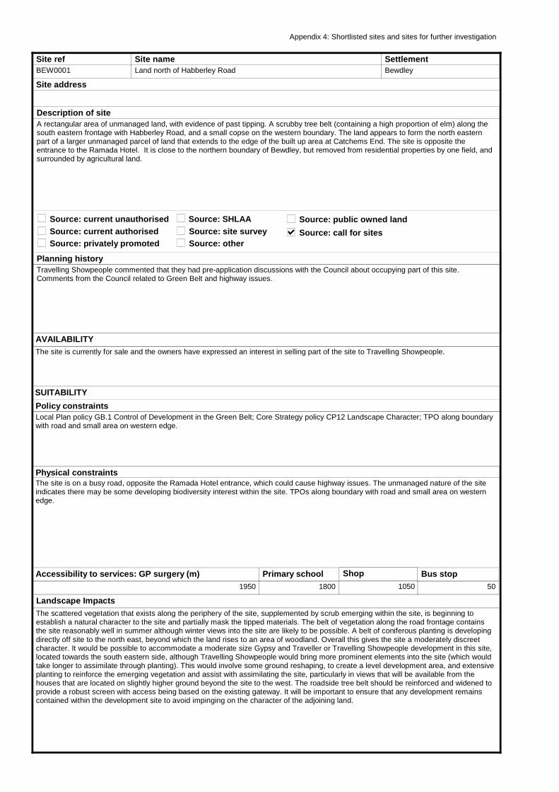
Site refBEW0001
Site nameLand north of Habberley Road
Site address
Planning historyTravelling Showpeople commented that they had pre-application discussions with the Council about occupying part of this site. Comments from the Council related to Green Belt and highway issues.
AVAILABILITYThe site is currently for sale and the owners have expressed an interest in selling part of the site to Travelling Showpeople.
SettlementBewdley
Source: current unauthorised
Description of siteA rectangular area of unmanaged land, with evidence of past tipping. A scrubby tree belt (containing a high proportion of elm) along the south eastern frontage with Habberley Road, and a small copse on the western boundary. The land appears to form the north eastern part of a larger unmanaged parcel of land that extends to the edge of the built up area at Catchems End. The site is opposite the entrance to the Ramada Hotel. It is close to the northern boundary of Bewdley, but removed from residential properties by one field, and surrounded by agricultural land.
Source: current authorisedSource: privately promoted
Source: public owned landSource: SHLAASource: site surveySource: other
Physical constraintsThe site is on a busy road, opposite the Ramada Hotel entrance, which could cause highway issues. The unmanaged nature of the site indicates there may be some developing biodiversity interest within the site. TPOs along boundary with road and small area on western edge.
Landscape ImpactsThe scattered vegetation that exists along the periphery of the site, supplemented by scrub emerging within the site, is beginning to establish a natural character to the site and partially mask the tipped materials. The belt of vegetation along the road frontage contains the site reasonably well in summer although winter views into the site are likely to be possible. A belt of coniferous planting is developing directly off site to the north east, beyond which the land rises to an area of woodland. Overall this gives the site a moderately discreet character. It would be possible to accommodate a moderate size Gypsy and Traveller or Travelling Showpeople development in this site, located towards the south eastern side, although Travelling Showpeople would bring more prominent elements into the site (which would take longer to assimilate through planting). This would involve some ground reshaping, to create a level development area, and extensive planting to reinforce the emerging vegetation and assist with assimilating the site, particularly in views that will be available from the houses that are located on slightly higher ground beyond the site to the west. The roadside tree belt should be reinforced and widened to provide a robust screen with access being based on the existing gateway. It will be important to ensure that any development remains contained within the development site to avoid impinging on the character of the adjoining land.
Policy constraintsLocal Plan policy GB.1 Control of Development in the Green Belt; Core Strategy policy CP12 Landscape Character; TPO along boundary with road and small area on western edge.
Accessibility to services: GP surgery (m)1950
Primary school1800
Shop
1050
Bus stop50
Appendix 4: Shortlisted sites and sites for further investigation
SUITABILITY
Source: call for sites
Other Potential ImpactsThe site is located in the Green Belt. Development within this apparently disturbed site would represent a limited encroachment into the open countryside protected by the Green Belt. Whilst the gap between the urban area and western outskirts of Kidderminster is only around 1km wide at this point the site is closely located to the existing urban edge of Catchems End, and north of the large hotel complex of The Heath Hotel, and is distinct from the land to the east due to a rise in landform and vegetation. If the site is to be identified for development it will be important to ensure that the extent and the form of the development is strictly controlled and does not set a precedent for development/expansion on adjoining land thereby reducing openness of the designated area. This may be achieved by creating a contained site as described above. There are a small number of houses nearby and therefore landscaping and planting may be required to protect residential amenity in their vicinity. There are also small areas of TPOs on the site.
ConclusionThe site is in the Green Belt and therefore special circumstances would be required to justify allocation. It is possible to accommodate a moderate size Gypsy and Traveller development in this site, located towards the south eastern side. A small Travelling Showpeople site could also be possible although it would bring more prominent elements into the site (which would take longer to assimilate through planting). Ground reshaping and mitigation measures relating to landscape impact and residential amenity would be required.
This map is reproduced from the Ordnance Survey map by Baker Associates with the permission of the Controller of Her Majesty's Stationery Office - Crown Copyright. All rights reserved. Wyre Forest District Council. License number: 100018317
ACHIEVABILITYThere are costs relating to levelling the ground and mitigation measure relating to minimising landscape impact. There may also be costs associated with highway improvements.
2013 - 2018 4
2018 - 2023 0
2023 - 2028 0
Potential Yield
DELIVERY
Potential occupantsRomany Gypsies or Travelling Showpeople
Delivery model
Privately owned traveller site requiring
planning permission.
Site available to be purchased and
occupied by traveller family.
Use of public grants to allow site to be
purchased and managed by travellers.
Existing public owned site to be developed
for publicly managed traveller provision.
Purchase of site by public bodies for
publicly managed traveller provision.
Type of use
Residential
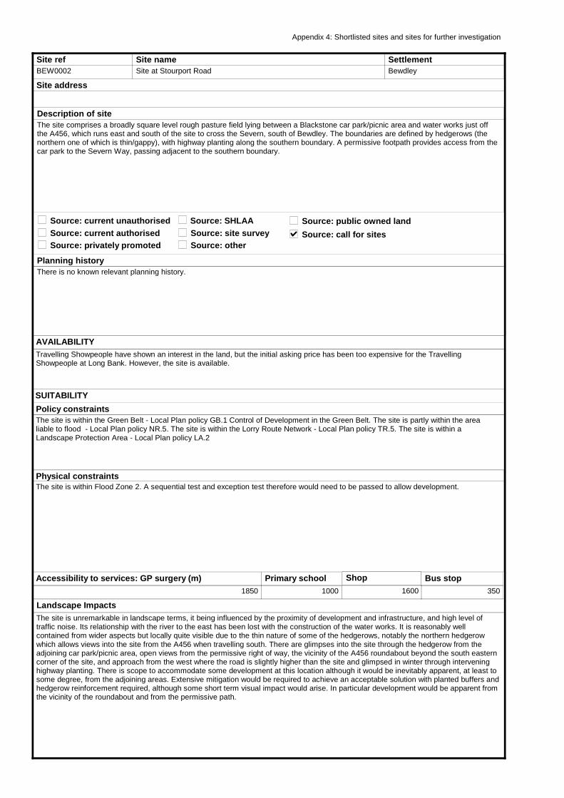
Site refBEW0002
Site nameSite at Stourport Road
Site address
Planning historyThere is no known relevant planning history.
AVAILABILITYTravelling Showpeople have shown an interest in the land, but the initial asking price has been too expensive for the Travelling Showpeople at Long Bank. However, the site is available.
SettlementBewdley
Source: current unauthorised
Description of siteThe site comprises a broadly square level rough pasture field lying between a Blackstone car park/picnic area and water works just off the A456, which runs east and south of the site to cross the Severn, south of Bewdley. The boundaries are defined by hedgerows (the northern one of which is thin/gappy), with highway planting along the southern boundary. A permissive footpath provides access from the car park to the Severn Way, passing adjacent to the southern boundary.
Source: current authorisedSource: privately promoted
Source: public owned landSource: SHLAASource: site surveySource: other
Physical constraintsThe site is within Flood Zone 2. A sequential test and exception test therefore would need to be passed to allow development.
Landscape ImpactsThe site is unremarkable in landscape terms, it being influenced by the proximity of development and infrastructure, and high level of traffic noise. Its relationship with the river to the east has been lost with the construction of the water works. It is reasonably well contained from wider aspects but locally quite visible due to the thin nature of some of the hedgerows, notably the northern hedgerow which allows views into the site from the A456 when travelling south. There are glimpses into the site through the hedgerow from the adjoining car park/picnic area, open views from the permissive right of way, the vicinity of the A456 roundabout beyond the south eastern corner of the site, and approach from the west where the road is slightly higher than the site and glimpsed in winter through intervening highway planting. There is scope to accommodate some development at this location although it would be inevitably apparent, at least to some degree, from the adjoining areas. Extensive mitigation would be required to achieve an acceptable solution with planted buffers and hedgerow reinforcement required, although some short term visual impact would arise. In particular development would be apparent from the vicinity of the roundabout and from the permissive path.
Policy constraintsThe site is within the Green Belt - Local Plan policy GB.1 Control of Development in the Green Belt. The site is partly within the area liable to flood - Local Plan policy NR.5. The site is within the Lorry Route Network - Local Plan policy TR.5. The site is within a Landscape Protection Area - Local Plan policy LA.2
Accessibility to services: GP surgery (m)1850
Primary school1000
Shop
1600
Bus stop350
Appendix 4: Shortlisted sites and sites for further investigation
SUITABILITY
Source: call for sites

Other Potential ImpactsThe site is within the Green Belt. The site is situated just within the edge of the Green Belt which is defined along the eastern bank of the river to the west. There is some scattered development within the vicinity and the site lies a relatively short distance from the southern periphery of the town. Development would reduce the openness of the site and is likely to be perceived, at least in the short term, as an encroachment into the countryside and Green Belt; the mitigation referred to above would reduce this perception over time. The site’s location close to the junction of two main roads suggest that this location could be considered as a transit site; this approach would ensure that development would be of a temporary nature, perhaps limited to summer months when the screening effect of vegetation is most effective; the need for more permanent structures and additional lighting may therefore be reduced or possibly avoided.Proximity to a major road may cause some noise and disturbance to potential residents, but could be mitigated through siting, bunding and landscaping.
ConclusionThe site is in the Green Belt and therefore special circumstances would be required to justify allocation. The site would need to pass the sequential test as it is located within Flood Zone 2. Otherwise, the site may have some future potential, subject to extensive landscaping mitigation. It is currently available.
This map is reproduced from the Ordnance Survey map by Baker Associates with the permission of the Controller of Her Majesty's Stationery Office - Crown Copyright. All rights reserved. Wyre Forest District Council. License number: 100018317
ACHIEVABILITY
2013 - 2018 15
2018 - 2023 0
2023 - 2028 0
Potential Yield
DELIVERY
Potential occupantsRomany Gypsies or Travelling Showpeople
Delivery model
Privately owned traveller site requiring
planning permission.
Site available to be purchased and
occupied by traveller family.
Use of public grants to allow site to be
purchased and managed by travellers.
Existing public owned site to be developed
for publicly managed traveller provision.
Purchase of site by public bodies for
publicly managed traveller provision.
Type of use
Residential or Transit
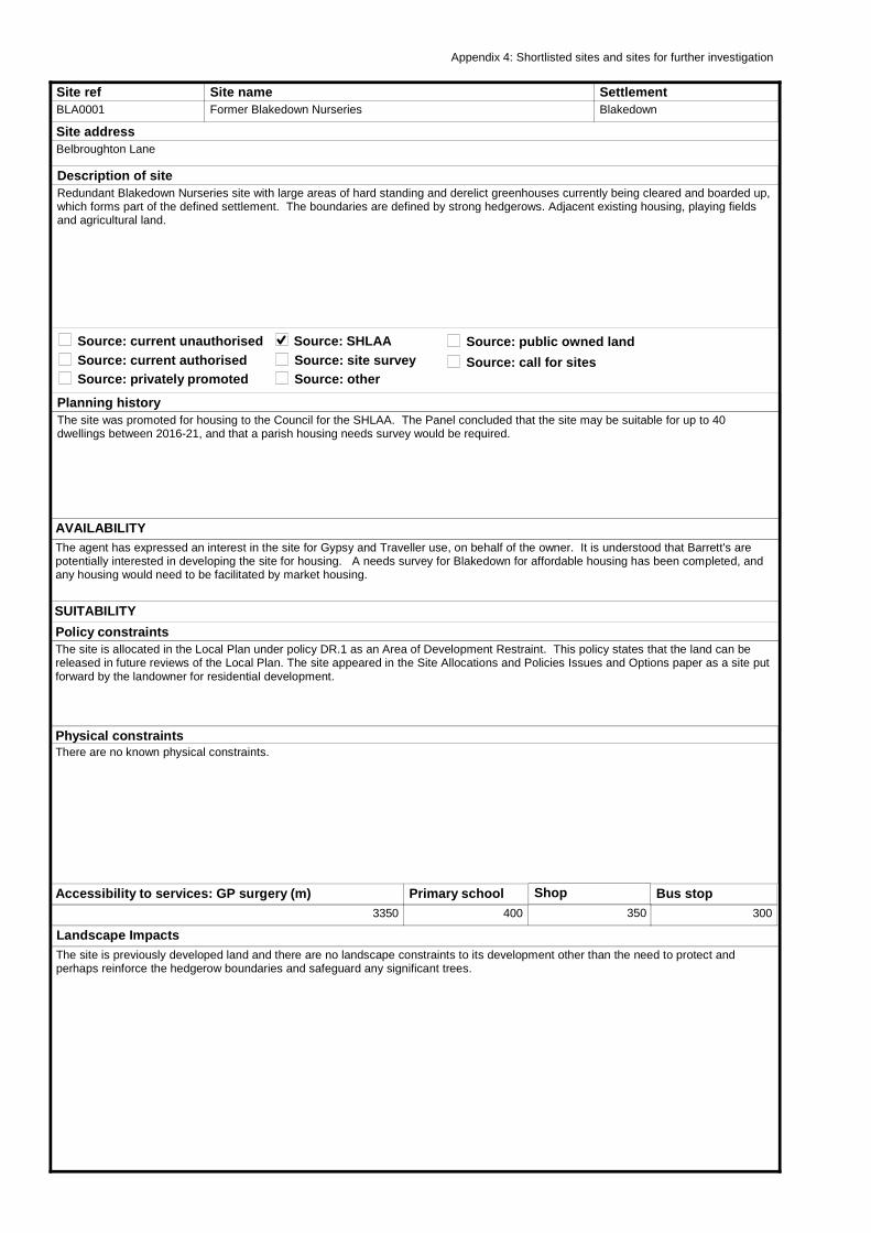
Site refBLA0001
Site nameFormer Blakedown Nurseries
Site addressBelbroughton Lane
Planning historyThe site was promoted for housing to the Council for the SHLAA. The Panel concluded that the site may be suitable for up to 40 dwellings between 2016-21, and that a parish housing needs survey would be required.
AVAILABILITYThe agent has expressed an interest in the site for Gypsy and Traveller use, on behalf of the owner. It is understood that Barrett's are potentially interested in developing the site for housing. A needs survey for Blakedown for affordable housing has been completed, and any housing would need to be facilitated by market housing.
SettlementBlakedown
Source: current unauthorised
Description of siteRedundant Blakedown Nurseries site with large areas of hard standing and derelict greenhouses currently being cleared and boarded up, which forms part of the defined settlement. The boundaries are defined by strong hedgerows. Adjacent existing housing, playing fields and agricultural land.
Source: current authorisedSource: privately promoted
Source: public owned landSource: SHLAASource: site surveySource: other
Physical constraintsThere are no known physical constraints.
Landscape ImpactsThe site is previously developed land and there are no landscape constraints to its development other than the need to protect and perhaps reinforce the hedgerow boundaries and safeguard any significant trees.
Policy constraintsThe site is allocated in the Local Plan under policy DR.1 as an Area of Development Restraint. This policy states that the land can be released in future reviews of the Local Plan. The site appeared in the Site Allocations and Policies Issues and Options paper as a site put forward by the landowner for residential development.
Accessibility to services: GP surgery (m)3350
Primary school400
Shop
350
Bus stop300
Appendix 4: Shortlisted sites and sites for further investigation
SUITABILITY
Source: call for sites
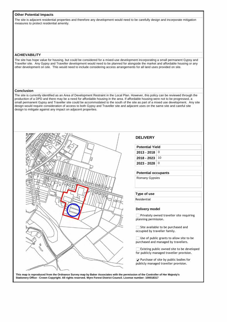
Other Potential ImpactsThe site is adjacent residential properties and therefore any development would need to be carefully design and incorporate mitigation measures to protect residential amenity.
ConclusionThe site is currently identified as an Area of Development Restraint in the Local Plan. However, this policy can be reviewed through the production of a DPD and there may be a need for affordable housing in the area. If affordable housing were not to be progressed, a small permanent Gypsy and Traveller site could be accommodated to the south of the site as part of a mixed use development. Any site design would require consideration of access to both Gypsy and Traveller site and adjacent uses on the same site and careful site design to mitigate against any impact on adjacent properties.
This map is reproduced from the Ordnance Survey map by Baker Associates with the permission of the Controller of Her Majesty's Stationery Office - Crown Copyright. All rights reserved. Wyre Forest District Council. License number: 100018317
ACHIEVABILITYThe site has hope value for housing, but could be considered for a mixed-use development incorporating a small permanent Gypsy and Traveller site. Any Gypsy and Traveller development would need to be planned for alongside the market and affordable housing or any other development on site. This would need to include considering access arrangements for all land uses provided on site.
2013 - 2018 0
2018 - 2023 10
2023 - 2028 0
Potential Yield
DELIVERY
Potential occupantsRomany Gypsies
Delivery model
Privately owned traveller site requiring
planning permission.
Site available to be purchased and
occupied by traveller family.
Use of public grants to allow site to be
purchased and managed by travellers.
Existing public owned site to be developed
for publicly managed traveller provision.
Purchase of site by public bodies for
publicly managed traveller provision.
Type of use
Residential
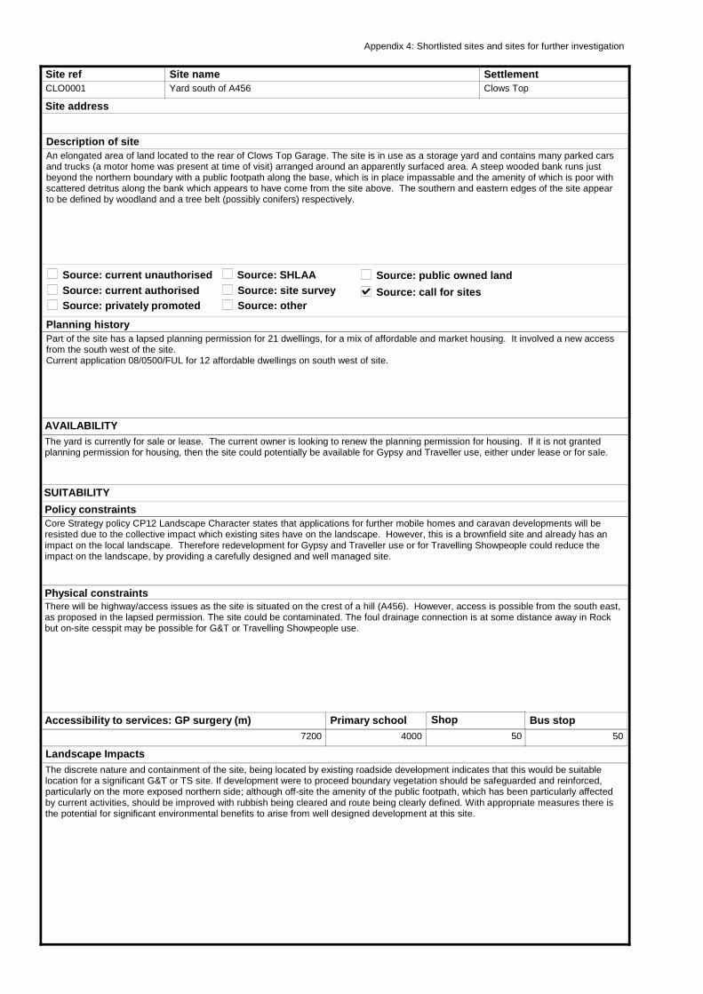
Site refCLO0001
Site nameYard south of A456
Site address
Planning historyPart of the site has a lapsed planning permission for 21 dwellings, for a mix of affordable and market housing. It involved a new access from the south west of the site.Current application 08/0500/FUL for 12 affordable dwellings on south west of site.
AVAILABILITYThe yard is currently for sale or lease. The current owner is looking to renew the planning permission for housing. If it is not granted planning permission for housing, then the site could potentially be available for Gypsy and Traveller use, either under lease or for sale.
SettlementClows Top
Source: current unauthorised
Description of siteAn elongated area of land located to the rear of Clows Top Garage. The site is in use as a storage yard and contains many parked cars and trucks (a motor home was present at time of visit) arranged around an apparently surfaced area. A steep wooded bank runs just beyond the northern boundary with a public footpath along the base, which is in place impassable and the amenity of which is poor with scattered detritus along the bank which appears to have come from the site above. The southern and eastern edges of the site appear to be defined by woodland and a tree belt (possibly conifers) respectively.
Source: current authorisedSource: privately promoted
Source: public owned landSource: SHLAASource: site surveySource: other
Physical constraintsThere will be highway/access issues as the site is situated on the crest of a hill (A456). However, access is possible from the south east, as proposed in the lapsed permission. The site could be contaminated. The foul drainage connection is at some distance away in Rock but on-site cesspit may be possible for G&T or Travelling Showpeople use.
Landscape ImpactsThe discrete nature and containment of the site, being located by existing roadside development indicates that this would be suitable location for a significant G&T or TS site. If development were to proceed boundary vegetation should be safeguarded and reinforced, particularly on the more exposed northern side; although off-site the amenity of the public footpath, which has been particularly affected by current activities, should be improved with rubbish being cleared and route being clearly defined. With appropriate measures there is the potential for significant environmental benefits to arise from well designed development at this site.
Policy constraintsCore Strategy policy CP12 Landscape Character states that applications for further mobile homes and caravan developments will be resisted due to the collective impact which existing sites have on the landscape. However, this is a brownfield site and already has an impact on the local landscape. Therefore redevelopment for Gypsy and Traveller use or for Travelling Showpeople could reduce the impact on the landscape, by providing a carefully designed and well managed site.
Accessibility to services: GP surgery (m)7200
Primary school4000
Shop
50
Bus stop50
Appendix 4: Shortlisted sites and sites for further investigation
SUITABILITY
Source: call for sites
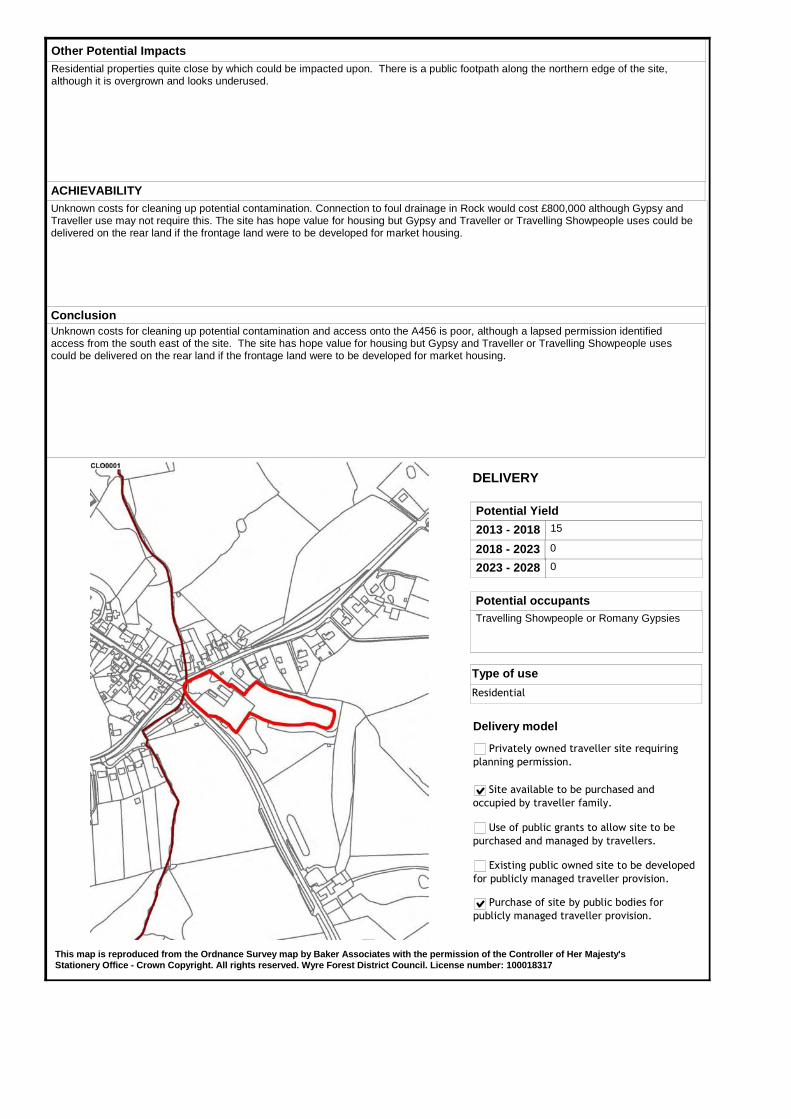
Other Potential ImpactsResidential properties quite close by which could be impacted upon. There is a public footpath along the northern edge of the site, although it is overgrown and looks underused.
ConclusionUnknown costs for cleaning up potential contamination and access onto the A456 is poor, although a lapsed permission identified access from the south east of the site. The site has hope value for housing but Gypsy and Traveller or Travelling Showpeople uses could be delivered on the rear land if the frontage land were to be developed for market housing.
This map is reproduced from the Ordnance Survey map by Baker Associates with the permission of the Controller of Her Majesty's Stationery Office - Crown Copyright. All rights reserved. Wyre Forest District Council. License number: 100018317
ACHIEVABILITYUnknown costs for cleaning up potential contamination. Connection to foul drainage in Rock would cost £800,000 although Gypsy and Traveller use may not require this. The site has hope value for housing but Gypsy and Traveller or Travelling Showpeople uses could be delivered on the rear land if the frontage land were to be developed for market housing.
2013 - 2018 15
2018 - 2023 0
2023 - 2028 0
Potential Yield
DELIVERY
Potential occupantsTravelling Showpeople or Romany Gypsies
Delivery model
Privately owned traveller site requiring
planning permission.
Site available to be purchased and
occupied by traveller family.
Use of public grants to allow site to be
purchased and managed by travellers.
Existing public owned site to be developed
for publicly managed traveller provision.
Purchase of site by public bodies for
publicly managed traveller provision.
Type of use
Residential

Site refCOOK0002
Site nameLand at Lawnswood
Site addressWesthead Road
Planning historyThe site was promoted for housing to the Council for the SHLAA and the Panel's view was that part of the site may be suitable for affordable housing if further sites are required within Cookley.
AVAILABILITYThe landowner has said that the site would ideally be developed for housing, but that the site could potentially be available for Gypsy and Traveller use. There may be potential for a mix of housing types including Gypsy and Traveller use.
SettlementCookley
Source: current unauthorised
Description of siteA roughly triangular site comprising part of a larger area of developing woodland, interspersed with areas of rough grass and scrub, surrounding a house on the west side of Cookley. There is a very well worn path along a linear clearing just beyond the southern boundary of the site, with trees in the northern end of the site. Access to the site is good via Westhead Road North.
Source: current authorisedSource: privately promoted
Source: public owned landSource: SHLAASource: site surveySource: other
Physical constraintsThe site has good access. There may be ecological constraints to development and there are quite a few trees on site. The site could provide the opportunity to open access from adjacent residential properties to the local centre and facilities, by providing a footpath through the site.
Landscape ImpactsThe vegetation within the site creates a noticeably discrete area within a clearing around the house. The southern eastern part is open to partial views from the rear of the houses to the east. There is scope to accommodate a very small number of units within this site, as long as these avoid incursions into the woodland; if well sited such development could be discrete although the south eastern boundary is more sensitive and screen planting may need to be introduced to protect the amenity of the adjoining properties. Access is likely to involve a slight widening of the existing access through the hedgerow at the end of Westhead Road North, a route shared with the unofficial path.
Policy constraintsThe site is within the Green Belt - Local Plan policy GB.1 Control of Development in the Green Belt. Core Strategy policy CP12 Landscape Character states that applications for further mobiles homes and caravan developments will be resisted due to the collective impact which existing sites have on the landscape. However, this site has housing development on 3 sides and is on the edge of an urban area.
Accessibility to services: GP surgery (m)300
Primary school250
Shop
400
Bus stop400
Appendix 4: Shortlisted sites and sites for further investigation
SUITABILITY
Source: call for sites
Other Potential ImpactsThe site is located in the Green Belt. A small part of the site is already developed and therefore potentially suitable for redevelopment without harm to the Green Belt. However, a site for a number of units would extend development into undeveloped land. There is the potential for this to create pressure for development in the two adjoining residential plots which may be difficult to resist and which, cumulatively, could lead to an erosion of the Green Belt in this area.
ConclusionThe site is in the Green Belt and therefore special circumstances would be required to justify allocation. However, the site appears to otherwise suitable if mitigation measures are undertaken, and subject to the site being assessed for potential ecological constraints and impact on residential amenity.
This map is reproduced from the Ordnance Survey map by Baker Associates with the permission of the Controller of Her Majesty's Stationery Office - Crown Copyright. All rights reserved. Wyre Forest District Council. License number: 100018317
ACHIEVABILITYThe site does have a hope value for housing. However, there are no other site constraints needing to be overcome.
2013 - 2018 5
2018 - 2023 0
2023 - 2028 0
Potential Yield
DELIVERY
Potential occupantsRomany Gypsies
Delivery model
Privately owned traveller site requiring
planning permission.
Site available to be purchased and
occupied by traveller family.
Use of public grants to allow site to be
purchased and managed by travellers.
Existing public owned site to be developed
for publicly managed traveller provision.
Purchase of site by public bodies for
publicly managed traveller provision.
Type of use
Residential
Site refFAIR0001
Site nameLand off Lowe Lane
Site addressFairfield Lane
Planning historyThe site was promoted for housing to the Council for the SHLAA, and the Panel's view was that the site may be suitable for up to a maximum of 90 dwellings. The pasture field to the north has planning permission for affordable housing.
AVAILABILITYThe larger pasture field is owned by the District Council and this part is deemed available for Gypsy and Traveller use. The availability for other parts of the site is unknown at present.
SettlementFairfield
Source: current unauthorised
Description of siteThe site comprises two pasture fields located on the southern side of Fairfield. Another pasture field and a housing estate lie to the north. The southern most field is defined by a partial hedge. Fairfield Lane forms the southern boundary and is lined by a prominent belt of coniferous trees.
Source: current authorisedSource: privately promoted
Source: public owned landSource: SHLAASource: site surveySource: other
Physical constraintsAccess would be better served from the north of the site through the pasture field which currently has permission for affordable housing. Therefore the site needs to be planned with the site at the north. There are high voltage cables on site which need 8m clearance either side.
Landscape ImpactsThe sites lie in the Sandstone Estatelands LCT. Adjoining undeveloped land lies within the Green Belt. The urban edge is prominent especially on higher ground to the north and this part of the site is more exposed to longer distance views as the ground falls away to the south east. The land has been excluded from Green Belt, presumably to allow for urban expansion suggesting that the principle of development is accepted in this location. However, the nature of G&T development would not sit comfortably in this landscape and conventional residential development would be more in character and could deliver a better urban edge. Suitable access appears to be only available from the estate road to the north; however, this part of the site is the most prominent, although associated with a backdrop of development. The south east corner of Site FAIR0001 forms a triangular plot of grassland associated with a large detached house to the east. This plot is much more contained and has the potential to accommodate a small development, where the adjoining road is slightly wider. The rest of the site is not considered to be a suitable location for G&T development.
Policy constraintsThe site is allocated in the Local Plan under policy DR.1 as an Area of Development Restraint. This policy states that the land can be released in future reviews of the Local Plan.
Accessibility to services: GP surgery (m)950
Primary school900
Shop
150
Bus stop350
Appendix 4: Shortlisted sites and sites for further investigation
SUITABILITY
Source: call for sites
Other Potential ImpactsThere are no other known potential impacts.
ConclusionMost of this site is available and suitable for Gypsy and Traveller use. If developed in isolation then the best location in relation to landscape impact, for Gypsy and Traveller use, is the small area within the south east corner of the site. However, the northern part of the larger pasture field could be developed in the medium term with access from the land to the north of the site which has planning permission for affordable homes. There are high voltage cables on site which need to be considered within any design.
This map is reproduced from the Ordnance Survey map by Baker Associates with the permission of the Controller of Her Majesty's Stationery Office - Crown Copyright. All rights reserved. Wyre Forest District Council. License number: 100018317
ACHIEVABILITYNo abnormal site constraints needing to be overcome, although access would best be achieved through the site to the north, which has planning permission for affordable housing.
2013 - 2018 2
2018 - 2023 10
2023 - 2028 0
Potential Yield
DELIVERY
Potential occupantsRomany Gypsies
Delivery model
Privately owned traveller site requiring
planning permission.
Site available to be purchased and
occupied by traveller family.
Use of public grants to allow site to be
purchased and managed by travellers.
Existing public owned site to be developed
for publicly managed traveller provision.
Purchase of site by public bodies for
publicly managed traveller provision.
Type of use
Residential
Site refGJAL
Site nameSchool site
Site addressSion Hill
Planning historyWorcestershire County Council had permission to change the site into an adult education centre, but this has not been implemented due to a lack of funding.
AVAILABILITYThe site is owned by Worcestershire County Council. The playing fields are used by an adjacent primary school and potentially not available for development. The Council is now looking to level the site and redevelop it. As the site is publicly owned the site is deemed available for Gypsy and Traveller use, in principle.
SettlementKidderminster
Source: current unauthorised
Description of siteSite comprises a redundant school located on top of a broad ridge at the western end, with playing fields to the east located on the northern edge of Kidderminster. Residential development lies to the south, the edge of which is followed by a public footpath, with a tree belt and hedgerow defining the northern and eastern boundaries with countryside respectively.
Source: current authorisedSource: privately promoted
Source: public owned landSource: SHLAASource: site surveySource: other
Physical constraintsSion Hill is steep, and there are also existing school buildings on site which may need to be cleared.
Landscape ImpactsThe site is within Sandstone Estatelands LCT. The existing school buildings constitute previously developed land and there is no constraint to development in this location, which has good access, subject to protecting the visual amenity of adjoining properties. The open playing field is much less suitable, forming an uninterrupted area of open grassland which is in an elevated position. It would be difficult to assimilate development in this context.
Policy constraintsThe site is within the Green Belt - Local Plan policy GB.1 Control of Development in the Green Belt. Policy CP12 of the Adopted Core Strategy indicates that mobile home, caravan and chalet development will be resisted ‘due to the collective impact which the existing sites have on the landscape. However, part of the site is brownfield and comprises existing school buildings which is larger in scale and probably has a bigger impact on the landscape than a small Gypsy and Traveller site.
Accessibility to services: GP surgery (m)1600
Primary school250
Shop
350
Bus stop150
Appendix 4: Shortlisted sites and sites for further investigation
SUITABILITY
Source: call for sites
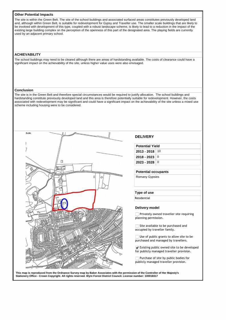
Other Potential ImpactsThe site is within the Green Belt. The site of the school buildings and associated surfaced areas constitutes previously developed land and, although within Green Belt, is suitable for redevelopment for Gypsy and Traveller use. The smaller scale buildings that are likely to be involved with development of this type, coupled with a robust landscape scheme, is likely to lead to a reduction in the impact of the existing large building complex on the perception of the openness of this part of the designated area. The playing fields are currently used by an adjacent primary school.
ConclusionThe site is in the Green Belt and therefore special circumstances would be required to justify allocation. The school buildings and hardstanding constitute previously developed land and this area is therefore potentially suitable for redevelopment. However, the costs associated with redevelopment may be significant and could have a significant impact on the achievability of the site unless a mixed use scheme including housing were to be considered.
This map is reproduced from the Ordnance Survey map by Baker Associates with the permission of the Controller of Her Majesty's Stationery Office - Crown Copyright. All rights reserved. Wyre Forest District Council. License number: 100018317
ACHIEVABILITYThe school buildings may need to be cleared although there are areas of hardstanding available. The costs of clearance could have a significant impact on the achievability of the site, unless higher value uses were also envisaged.
2013 - 2018 10
2018 - 2023 0
2023 - 2028 0
Potential Yield
DELIVERY
Potential occupantsRomany Gypsies
Delivery model
Privately owned traveller site requiring
planning permission.
Site available to be purchased and
occupied by traveller family.
Use of public grants to allow site to be
purchased and managed by travellers.
Existing public owned site to be developed
for publicly managed traveller provision.
Purchase of site by public bodies for
publicly managed traveller provision.
Type of use
Residential
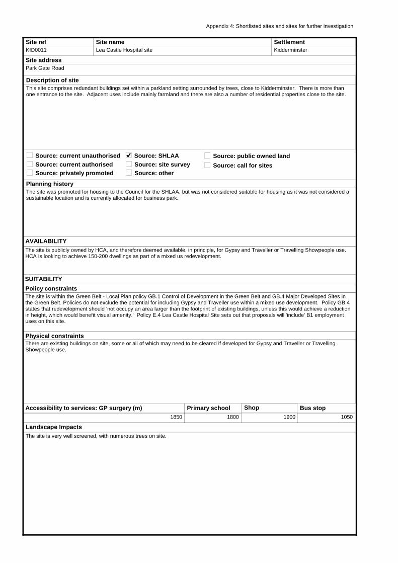
Site refKID0011
Site nameLea Castle Hospital site
Site addressPark Gate Road
Planning historyThe site was promoted for housing to the Council for the SHLAA, but was not considered suitable for housing as it was not considered a sustainable location and is currently allocated for business park.
AVAILABILITYThe site is publicly owned by HCA, and therefore deemed available, in principle, for Gypsy and Traveller or Travelling Showpeople use. HCA is looking to achieve 150-200 dwellings as part of a mixed us redevelopment.
SettlementKidderminster
Source: current unauthorised
Description of siteThis site comprises redundant buildings set within a parkland setting surrounded by trees, close to Kidderminster. There is more than one entrance to the site. Adjacent uses include mainly farmland and there are also a number of residential properties close to the site.
Source: current authorisedSource: privately promoted
Source: public owned landSource: SHLAASource: site surveySource: other
Physical constraintsThere are existing buildings on site, some or all of which may need to be cleared if developed for Gypsy and Traveller or Travelling Showpeople use.
Landscape ImpactsThe site is very well screened, with numerous trees on site.
Policy constraintsThe site is within the Green Belt - Local Plan policy GB.1 Control of Development in the Green Belt and GB.4 Major Developed Sites in the Green Belt. Policies do not exclude the potential for including Gypsy and Traveller use within a mixed use development. Policy GB.4 states that redevelopment should 'not occupy an area larger than the footprint of existing buildings, unless this would achieve a reduction in height, which would benefit visual amenity.' Policy E.4 Lea Castle Hospital Site sets out that proposals will 'include' B1 employment uses on this site.
Accessibility to services: GP surgery (m)1850
Primary school1800
Shop
1900
Bus stop1050
Appendix 4: Shortlisted sites and sites for further investigation
SUITABILITY
Source: call for sites
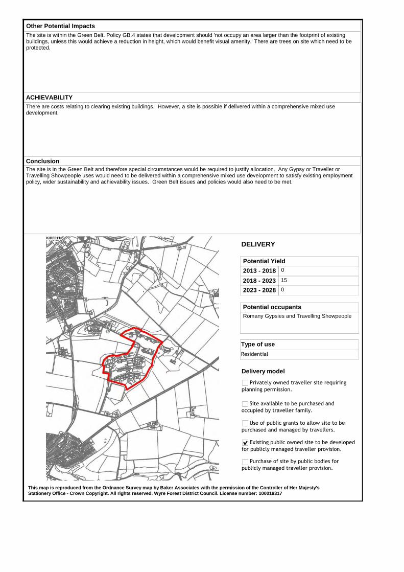
Other Potential ImpactsThe site is within the Green Belt. Policy GB.4 states that development should 'not occupy an area larger than the footprint of existing buildings, unless this would achieve a reduction in height, which would benefit visual amenity.' There are trees on site which need to be protected.
ConclusionThe site is in the Green Belt and therefore special circumstances would be required to justify allocation. Any Gypsy or Traveller or Travelling Showpeople uses would need to be delivered within a comprehensive mixed use development to satisfy existing employment policy, wider sustainability and achievability issues. Green Belt issues and policies would also need to be met.
This map is reproduced from the Ordnance Survey map by Baker Associates with the permission of the Controller of Her Majesty's Stationery Office - Crown Copyright. All rights reserved. Wyre Forest District Council. License number: 100018317
ACHIEVABILITYThere are costs relating to clearing existing buildings. However, a site is possible if delivered within a comprehensive mixed use development.
2013 - 2018 0
2018 - 2023 15
2023 - 2028 0
Potential Yield
DELIVERY
Potential occupantsRomany Gypsies and Travelling Showpeople
Delivery model
Privately owned traveller site requiring
planning permission.
Site available to be purchased and
occupied by traveller family.
Use of public grants to allow site to be
purchased and managed by travellers.
Existing public owned site to be developed
for publicly managed traveller provision.
Purchase of site by public bodies for
publicly managed traveller provision.
Type of use
Residential
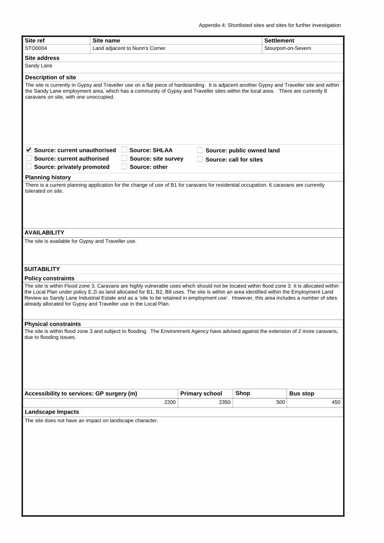
Site refSTO0004
Site nameLand adjacent to Nunn's Corner
Site addressSandy Lane
Planning historyThere is a current planning application for the change of use of B1 for caravans for residential occupation. 6 caravans are currently tolerated on site.
AVAILABILITYThe site is available for Gypsy and Traveller use.
SettlementStourport-on-Severn
Source: current unauthorised
Description of siteThe site is currently in Gypsy and Traveller use on a flat piece of hardstanding. It is adjacent another Gypsy and Traveller site and within the Sandy Lane employment area, which has a community of Gypsy and Traveller sites within the local area. There are currently 8 caravans on site, with one unoccupied.
Source: current authorisedSource: privately promoted
Source: public owned landSource: SHLAASource: site surveySource: other
Physical constraintsThe site is within flood zone 3 and subject to flooding. The Environment Agency have advised against the extension of 2 more caravans, due to flooding issues.
Landscape ImpactsThe site does not have an impact on landscape character.
Policy constraintsThe site is within Flood zone 3. Caravans are highly vulnerable uses which should not be located within flood zone 3. It is allocated within the Local Plan under policy E.2i as land allocated for B1, B2, B8 uses. The site is within an area identified within the Employment Land Review as Sandy Lane Industrial Estate and as a ‘site to be retained in employment use’. However, this area includes a number of sites already allocated for Gypsy and Traveller use in the Local Plan.
Accessibility to services: GP surgery (m)2200
Primary school2350
Shop
500
Bus stop450
Appendix 4: Shortlisted sites and sites for further investigation
SUITABILITY
Source: call for sites
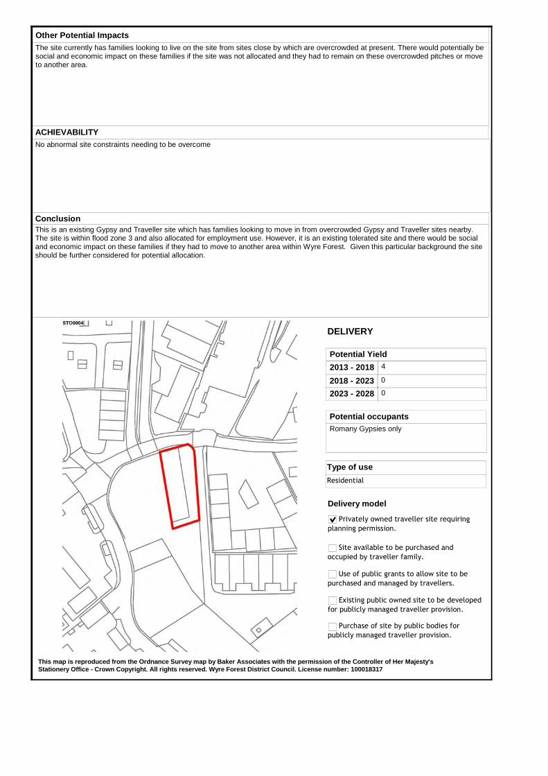
Other Potential ImpactsThe site currently has families looking to live on the site from sites close by which are overcrowded at present. There would potentially be social and economic impact on these families if the site was not allocated and they had to remain on these overcrowded pitches or move to another area.
ConclusionThis is an existing Gypsy and Traveller site which has families looking to move in from overcrowded Gypsy and Traveller sites nearby. The site is within flood zone 3 and also allocated for employment use. However, it is an existing tolerated site and there would be social and economic impact on these families if they had to move to another area within Wyre Forest. Given this particular background the site should be further considered for potential allocation.
This map is reproduced from the Ordnance Survey map by Baker Associates with the permission of the Controller of Her Majesty's Stationery Office - Crown Copyright. All rights reserved. Wyre Forest District Council. License number: 100018317
ACHIEVABILITYNo abnormal site constraints needing to be overcome
2013 - 2018 4
2018 - 2023 0
2023 - 2028 0
Potential Yield
DELIVERY
Potential occupantsRomany Gypsies only
Delivery model
Privately owned traveller site requiring
planning permission.
Site available to be purchased and
occupied by traveller family.
Use of public grants to allow site to be
purchased and managed by travellers.
Existing public owned site to be developed
for publicly managed traveller provision.
Purchase of site by public bodies for
publicly managed traveller provision.
Type of use
Residential
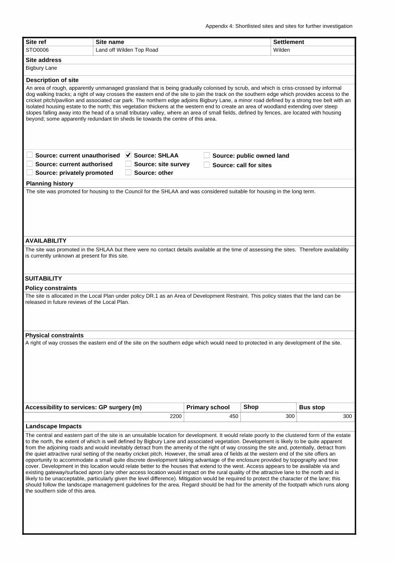
Site refSTO0006
Site nameLand off Wilden Top Road
Site addressBigbury Lane
Planning historyThe site was promoted for housing to the Council for the SHLAA and was considered suitable for housing in the long term.
AVAILABILITYThe site was promoted in the SHLAA but there were no contact details available at the time of assessing the sites. Therefore availability is currently unknown at present for this site.
SettlementWilden
Source: current unauthorised
Description of siteAn area of rough, apparently unmanaged grassland that is being gradually colonised by scrub, and which is criss-crossed by informal dog walking tracks; a right of way crosses the eastern end of the site to join the track on the southern edge which provides access to the cricket pitch/pavilion and associated car park. The northern edge adjoins Bigbury Lane, a minor road defined by a strong tree belt with an isolated housing estate to the north; this vegetation thickens at the western end to create an area of woodland extending over steep slopes falling away into the head of a small tributary valley, where an area of small fields, defined by fences, are located with housing beyond; some apparently redundant tin sheds lie towards the centre of this area.
Source: current authorisedSource: privately promoted
Source: public owned landSource: SHLAASource: site surveySource: other
Physical constraintsA right of way crosses the eastern end of the site on the southern edge which would need to protected in any development of the site.
Landscape ImpactsThe central and eastern part of the site is an unsuitable location for development. It would relate poorly to the clustered form of the estate to the north, the extent of which is well defined by Bigbury Lane and associated vegetation. Development is likely to be quite apparent from the adjoining roads and would inevitably detract from the amenity of the right of way crossing the site and, potentially, detract from the quiet attractive rural setting of the nearby cricket pitch. However, the small area of fields at the western end of the site offers an opportunity to accommodate a small quite discrete development taking advantage of the enclosure provided by topography and tree cover. Development in this location would relate better to the houses that extend to the west. Access appears to be available via and existing gateway/surfaced apron (any other access location would impact on the rural quality of the attractive lane to the north and is likely to be unacceptable, particularly given the level difference). Mitigation would be required to protect the character of the lane; this should follow the landscape management guidelines for the area. Regard should be had for the amenity of the footpath which runs along the southern side of this area.
Policy constraintsThe site is allocated in the Local Plan under policy DR.1 as an Area of Development Restraint. This policy states that the land can be released in future reviews of the Local Plan.
Accessibility to services: GP surgery (m)2200
Primary school450
Shop
300
Bus stop300
Appendix 4: Shortlisted sites and sites for further investigation
SUITABILITY
Source: call for sites
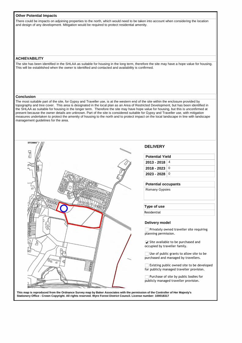
Other Potential ImpactsThere could be impacts on adjoining properties to the north, which would need to be taken into account when considering the location and design of any development. Mitigation would be required to protect residential amenity.
ConclusionThe most suitable part of the site, for Gypsy and Traveller use, is at the western end of the site within the enclosure provided by topography and tree cover. This area is designated in the local plan as an Area of Restricted Development, but has been identified in the SHLAA as suitable for housing in the longer term. Therefore the site may have hope value for housing, but this is unconfirmed at present because the owner details are unknown. Part of the site is considered suitable for Gypsy and Traveller use, with mitigation measures undertaken to protect the amenity of housing to the north and to protect impact on the local landscape in line with landscape management guidelines for the area.
This map is reproduced from the Ordnance Survey map by Baker Associates with the permission of the Controller of Her Majesty's Stationery Office - Crown Copyright. All rights reserved. Wyre Forest District Council. License number: 100018317
ACHIEVABILITYThe site has been identified in the SHLAA as suitable for housing in the long term, therefore the site may have a hope value for housing. This will be established when the owner is identified and contacted and availability is confirmed.
2013 - 2018 4
2018 - 2023 0
2023 - 2028 0
Potential Yield
DELIVERY
Potential occupantsRomany Gypsies
Delivery model
Privately owned traveller site requiring
planning permission.
Site available to be purchased and
occupied by traveller family.
Use of public grants to allow site to be
purchased and managed by travellers.
Existing public owned site to be developed
for publicly managed traveller provision.
Purchase of site by public bodies for
publicly managed traveller provision.
Type of use
Residential
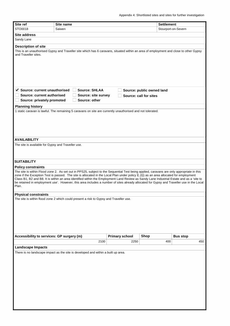
Site refSTO0018
Site nameSaiwen
Site addressSandy Lane
Planning history1 static caravan is lawful. The remaining 5 caravans on site are currently unauthorised and not tolerated.
AVAILABILITYThe site is available for Gypsy and Traveller use.
SettlementStourport-on-Severn
Source: current unauthorised
Description of siteThis is an unauthorised Gypsy and Traveller site which has 6 caravans, situated within an area of employment and close to other Gypsy and Traveller sites.
Source: current authorisedSource: privately promoted
Source: public owned landSource: SHLAASource: site surveySource: other
Physical constraintsThe site is within flood zone 2 which could present a risk to Gypsy and Traveller use.
Landscape ImpactsThere is no landscape impact as the site is developed and within a built up area.
Policy constraintsThe site is within Flood zone 2. As set out in PPS25, subject to the Sequential Test being applied, caravans are only appropriate in this zone if the Exception Test is passed. The site is allocated in the Local Plan under policy E.2(i) as an area allocated for employment Class B1, B2 and B8. It is within an area identified within the Employment Land Review as Sandy Lane Industrial Estate and as a ‘site to be retained in employment use’. However, this area includes a number of sites already allocated for Gypsy and Traveller use in the Local Plan.
Accessibility to services: GP surgery (m)2100
Primary school2250
Shop
400
Bus stop450
Appendix 4: Shortlisted sites and sites for further investigation
SUITABILITY
Source: call for sites
Other Potential ImpactsThe site currently has families living in caravans. There would potentially be social and economic impact on these families if the site was not allocated and they had to move.
ConclusionThis is an existing Gypsy and Traveller site which has families residing on site. The site is within flood zone 2 and allocated for employment use. However, further investigation into flooding issues may be resolvable and the site is well related to existing residential uses and there may be social and economic impact on these families if they had to move.
This map is reproduced from the Ordnance Survey map by Baker Associates with the permission of the Controller of Her Majesty's Stationery Office - Crown Copyright. All rights reserved. Wyre Forest District Council. License number: 100018317
ACHIEVABILITYThere are no abnormal site constraints needing to be overcome.
2013 - 2018 3
2018 - 2023 0
2023 - 2028 0
Potential Yield
DELIVERY
Potential occupantsRomany Gypsies
Delivery model
Privately owned traveller site requiring
planning permission.
Site available to be purchased and
occupied by traveller family.
Use of public grants to allow site to be
purchased and managed by travellers.
Existing public owned site to be developed
for publicly managed traveller provision.
Purchase of site by public bodies for
publicly managed traveller provision.
Type of use
Residential
Site refSTO0019
Site nameThe Gables Yard
Site addressBroach Road
Planning historyPlanning permission (WF.956/87) was granted in 1987 for 5 residential caravans and storage of 2 touring caravans and the storage of building materials. A site licence (WFC/35) was granted for 5 caravans in 1996. There are currently 3 other caravans on site which are not tolerated.
AVAILABILITYThe site is currently occupied by families living in caravans and therefore deemed available for Gypsy and Traveller use.
SettlementStourport-on-Severn
Source: current unauthorised
Description of siteThis is an existing residential caravan site with 8 caravans on an area of flat hardstanding. It is adjacent another Gypsy and Traveller site and within the Sandy Lane employment area, which has a community of Gypsy and Traveller sites within the local area.
Source: current authorisedSource: privately promoted
Source: public owned landSource: SHLAASource: site surveySource: other
Physical constraintsThe site is within flood zone 2 and is therefore within an area of flood risk, which would require mitigation measures.
Landscape ImpactsThere is no landscape impact as the site is within a built up area.
Policy constraintsThe site is within Flood zone 2 and designated in the Local Plan under policy E.2(i) as an area allocated for employment Class B1, B2 and B8. However, the site has planning permission for residential caravan use, therefore Gypsy and Traveller use is appropriate in this location.
Accessibility to services: GP surgery (m)2100
Primary school2250
Shop
500
Bus stop550
Appendix 4: Shortlisted sites and sites for further investigation
SUITABILITY
Source: call for sites
Other Potential ImpactsThere are no known potential impacts.
ConclusionThe site is within flood zone 2 and allocated in the Local Plan for employment use. However, the site has planning permission for 5 residential caravans and 2 touring caravans and therefore continued Gypsy and Traveller use is appropriate in this location. It is therefore appropriate to safeguard the site for future Gypsy and Traveller uses.
This map is reproduced from the Ordnance Survey map by Baker Associates with the permission of the Controller of Her Majesty's Stationery Office - Crown Copyright. All rights reserved. Wyre Forest District Council. License number: 100018317
ACHIEVABILITYThere are no abnormal site constraints needing to be overcome.
2013 - 2018 3
2018 - 2023 0
2023 - 2028 0
Potential Yield
DELIVERY
Potential occupantsRomany Gypsies only
Delivery model
Privately owned traveller site requiring
planning permission.
Site available to be purchased and
occupied by traveller family.
Use of public grants to allow site to be
purchased and managed by travellers.
Existing public owned site to be developed
for publicly managed traveller provision.
Purchase of site by public bodies for
publicly managed traveller provision.
Type of use
Residential
Site refSTON0001
Site nameFormer Depot
Site addressButts Lane
Planning historyThe site was granted permission for 21 live/work units, but has not been implemented. The site was promoted for housing to the Council for the SHLAA, and was considered suitable for mixed use conversion scheme with live-work units and affordable housing with 31 units in total.
AVAILABILITYThe previous owners knocked down buildings to build live/work units, but then went into receivership. Site was sold to an unknown individual(s) and availability is currently unknown. The Council believes that the new owner wishes to develop out the original permission.
SettlementStone
Source: current unauthorised
Description of siteThe site is a mix of vacant agricultural buildings, partly cleared, and open land situated on a low ridge. The northern and western parts appear to contain a good number of trees, interspersed with areas of unmanaged land that is reverting to scrub. A house and grain silos lie in the south western part. Stanklyn Wood flanks the western side of the site and contains the site from the land beyond which falls away quite steeply. The central and southern parts of the site appear to have been cleared of buildings although trackways still appear to remain. There is a loose scattering of farms, dwellings and small hamlets in the area, associated with the minor road network.
Source: current authorisedSource: privately promoted
Source: public owned landSource: SHLAASource: site surveySource: other
Physical constraintsThere are a number of existing buildings on site which may constrain Gypsy and Traveller and Travelling Showpeople use.
Landscape ImpactsThe site lies within Estate Farmlands LCT. The site lies in a slightly prominent location on a low ridge. However, the tree cover within and adjoining the site appears to assimilate the site within the wider landscape. Being previously developed land the site, or at least parts of it, is suitable for development; however a detailed analysis is required to determine those areas that are more contained (particularly in winter months) and the most suitable for accommodating development.
Policy constraintsThe site is within the Green Belt - Local Plan policy GB.1 Control of Development in the Green Belt.
Accessibility to services: GP surgery (m)4000
Primary school2200
Shop
2150
Bus stop700
Appendix 4: Shortlisted sites and sites for further investigation
SUITABILITY
Source: call for sites
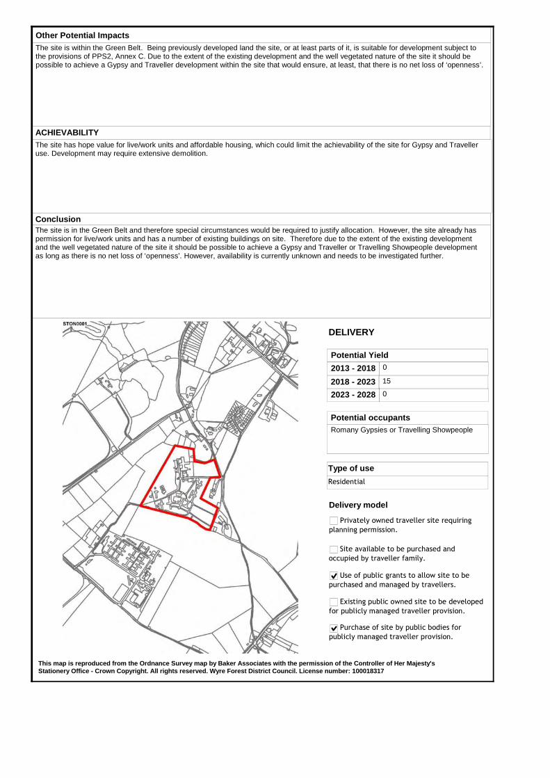
Other Potential ImpactsThe site is within the Green Belt. Being previously developed land the site, or at least parts of it, is suitable for development subject to the provisions of PPS2, Annex C. Due to the extent of the existing development and the well vegetated nature of the site it should be possible to achieve a Gypsy and Traveller development within the site that would ensure, at least, that there is no net loss of ‘openness’.
ConclusionThe site is in the Green Belt and therefore special circumstances would be required to justify allocation. However, the site already has permission for live/work units and has a number of existing buildings on site. Therefore due to the extent of the existing development and the well vegetated nature of the site it should be possible to achieve a Gypsy and Traveller or Travelling Showpeople development as long as there is no net loss of ‘openness’. However, availability is currently unknown and needs to be investigated further.
This map is reproduced from the Ordnance Survey map by Baker Associates with the permission of the Controller of Her Majesty's Stationery Office - Crown Copyright. All rights reserved. Wyre Forest District Council. License number: 100018317
ACHIEVABILITYThe site has hope value for live/work units and affordable housing, which could limit the achievability of the site for Gypsy and Traveller use. Development may require extensive demolition.
2013 - 2018 0
2018 - 2023 15
2023 - 2028 0
Potential Yield
DELIVERY
Potential occupantsRomany Gypsies or Travelling Showpeople
Delivery model
Privately owned traveller site requiring
planning permission.
Site available to be purchased and
occupied by traveller family.
Use of public grants to allow site to be
purchased and managed by travellers.
Existing public owned site to be developed
for publicly managed traveller provision.
Purchase of site by public bodies for
publicly managed traveller provision.
Type of use
Residential
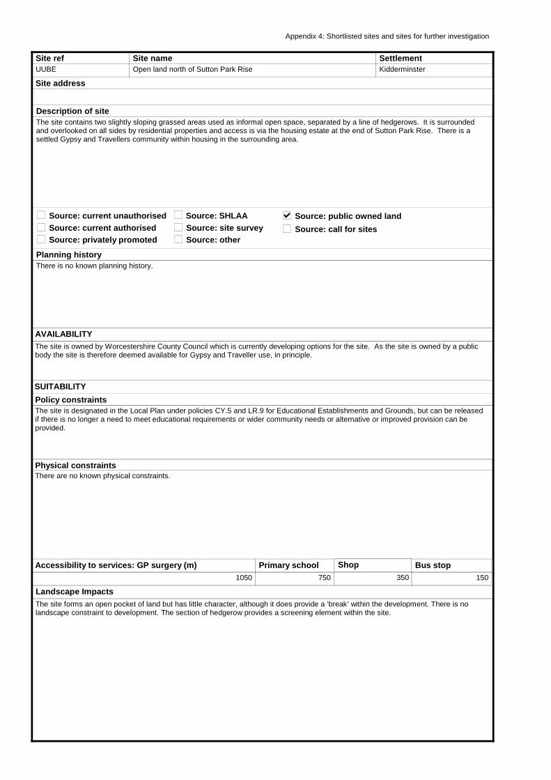
Site refUUBE
Site nameOpen land north of Sutton Park Rise
Site address
Planning historyThere is no known planning history.
AVAILABILITYThe site is owned by Worcestershire County Council which is currently developing options for the site. As the site is owned by a public body the site is therefore deemed available for Gypsy and Traveller use, in principle.
SettlementKidderminster
Source: current unauthorised
Description of siteThe site contains two slightly sloping grassed areas used as informal open space, separated by a line of hedgerows. It is surrounded and overlooked on all sides by residential properties and access is via the housing estate at the end of Sutton Park Rise. There is a settled Gypsy and Travellers community within housing in the surrounding area.
Source: current authorisedSource: privately promoted
Source: public owned landSource: SHLAASource: site surveySource: other
Physical constraintsThere are no known physical constraints.
Landscape ImpactsThe site forms an open pocket of land but has little character, although it does provide a ‘break’ within the development. There is no landscape constraint to development. The section of hedgerow provides a screening element within the site.
Policy constraintsThe site is designated in the Local Plan under policies CY.5 and LR.9 for Educational Establishments and Grounds, but can be released if there is no longer a need to meet educational requirements or wider community needs or alternative or improved provision can be provided.
Accessibility to services: GP surgery (m)1050
Primary school750
Shop
350
Bus stop150
Appendix 4: Shortlisted sites and sites for further investigation
SUITABILITY
Source: call for sites
Other Potential ImpactsThe site is close to housing and could impact on residential amenity. Therefore in any development there is a need to consider the location and layout of caravans to protect the residential amenity of adjoining residents and the privacy of potential occupants.
ConclusionThe site is designated for educational use but the County Council is currently developing options for the site. As it is publicly owned, part of the site is potentially available for Gypsy and Traveller use and is close to an existing Gypsy community in housing. In any development there will be a need to consider the location and layout of caravans to protect the residential amenity of adjoining residents and the privacy of potential occupants.
This map is reproduced from the Ordnance Survey map by Baker Associates with the permission of the Controller of Her Majesty's Stationery Office - Crown Copyright. All rights reserved. Wyre Forest District Council. License number: 100018317
ACHIEVABILITYThe site is being considered for redevelopment for mixed uses including education and housing. The County Council may be assuming housing development on part of the site to subsidise new educational uses.
2013 - 2018 15
2018 - 2023 0
2023 - 2028 0
Potential Yield
DELIVERY
Potential occupantsRomany Gypsies
Delivery model
Privately owned traveller site requiring
planning permission.
Site available to be purchased and
occupied by traveller family.
Use of public grants to allow site to be
purchased and managed by travellers.
Existing public owned site to be developed
for publicly managed traveller provision.
Purchase of site by public bodies for
publicly managed traveller provision.
Type of use
Residential
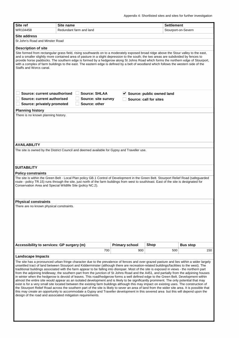
Site refWR104458
Site nameRedundant farm and land
Site addressSt John's Road and Minster Road
Planning historyThere is no known planning history.
AVAILABILITYThe site is owned by the District Council and deemed available for Gypsy and Traveller use.
SettlementStourport-on-Severn
Source: current unauthorised
Description of siteSite formed from rectangular grass field, rising southwards on to a moderately exposed broad ridge above the Stour valley to the east, and a smaller slightly more contained area of pasture in a slight depression to the south; the two areas are subdivided by fences to provide horse paddocks. The southern edge is formed by a hedgerow along St Johns Road which forms the northern edge of Stourport, with a complex of farm buildings to the east. The eastern edge is defined by a belt of woodland which follows the western side of the Staffs and Worcs canal.
Source: current authorisedSource: privately promoted
Source: public owned landSource: SHLAASource: site surveySource: other
Physical constraintsThere are no known physical constraints.
Landscape ImpactsThe site has a pronounced urban fringe character due to the prevalence of fences and over-grazed pasture and lies within a wider largely unsettled tract of land between Stourport and Kidderminster (although there are recreation-related buildings/facilities to the west). The traditional buildings associated with the farm appear to be falling into disrepair. Most of the site is exposed in views - the northern part from the adjoining bridleway; the southern part from the junction of St Johns Road and the A451, and partially from the adjoining houses in winter when the hedgerow is devoid of leaves. This road/hedgerow forms a well defined edge to the Green Belt. Development within almost the entire site would appear as an isolated development and is likely to be significantly prominent. The only potential that may exist is for a very small site located between the existing farm buildings although this may impact on existing uses. The construction of the Stourport Relief Road across the southern part of the site is likely to sever an area of land from the wider site area. It is possible that this may create an opportunity to accommodate a Gypsy and Traveller development in this severed area but this will depend upon the design of the road and associated mitigation requirements.
Policy constraintsThe site is within the Green Belt - Local Plan policy GB.1 Control of Development in the Green Belt. Stourport Relief Road (safeguarded route - policy TR.15) runs through the site, just north of the farm buildings from west to south/east. East of the site is designated for Conservation Area and Special Wildlife Site (policy NC.2).
Accessibility to services: GP surgery (m)700
Primary school900
Shop
500
Bus stop150
Appendix 4: Shortlisted sites and sites for further investigation
SUITABILITY
Source: call for sites
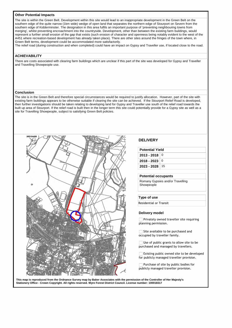
Other Potential ImpactsThe site is within the Green Belt. Development within this site would lead to an inappropriate development in the Green Belt on the southern edge of the quite narrow (1km wide) wedge of open land that separates the northern edge of Stourport on Severn from the southern edge of Kidderminster. The designation in this area fulfils an important purpose of ‘preventing neighbouring towns from merging’, whilst preventing encroachment into the countryside. Development, other than between the existing farm buildings, would represent a further small erosion of the gap that exists (such erosion of character and openness being notably evident to the west of the A451 where recreation-based development has already taken place). There are other sites around the fringes of the town where, in Green Belt terms, development could be accommodated more satisfactorily.The relief road (during construction and when completed) could have an impact on Gypsy and Traveller use, if located close to the road.
ConclusionThe site is in the Green Belt and therefore special circumstances would be required to justify allocation. However, part of the site with existing farm buildings appears to be otherwise suitable if clearing the site can be achieved. If the Stourport Relief Road is developed, then further investigations should be taken relating to developing land for Gypsy and Traveller use south of the relief road towards the built up area of Stourport. If the relief road is built then in the longer term this site could potentially provide for a Gypsy site as well as a site for Travelling Showpeople, subject to satisfying Green Belt policies.
This map is reproduced from the Ordnance Survey map by Baker Associates with the permission of the Controller of Her Majesty's Stationery Office - Crown Copyright. All rights reserved. Wyre Forest District Council. License number: 100018317
ACHIEVABILITYThere are costs associated with clearing farm buildings which are unclear if this part of the site was developed for Gypsy and Traveller and Travelling Showpeople use.
2013 - 2018 0
2018 - 2023 0
2023 - 2028 15
Potential Yield
DELIVERY
Potential occupantsRomany Gypsies and/or Travelling Showpeople
Delivery model
Privately owned traveller site requiring
planning permission.
Site available to be purchased and
occupied by traveller family.
Use of public grants to allow site to be
purchased and managed by travellers.
Existing public owned site to be developed
for publicly managed traveller provision.
Purchase of site by public bodies for
publicly managed traveller provision.
Type of use
Residential or Transit

Wyre Forest District: Assessment of potential sites for Gypsies, Travellers and Travelling Showpeople
Final Report - August 2011
Appendix 5: Design templates