Embed Size (px)
Citation preview
Benha Journal of Applied Sciences (BJAS) print: ISSN 2356–9751
Vol.(5) Issue(1) Part (1) (2020), (57-66) online: ISSN 2356–976x
http://bjas.journals.ekb.eg
Benha Journal Of Applied Sciences, Vol.(5) Issue(1) Part (1) (2020(
Assessment of Geological Structure in Nafoora Oil Field, Sirt Basin, Libya M.A.El Amowy
1, M.M.Afife
1, A.M.El Kowefi
2, A.M.Chahlol
3 and A.M.Mussa
1
1 Geology Dept., Faculty of Science, Benha Univ., Benha, Egypt
2 Geology Dept., Faculty of Science, Benghazi Univ., Libya
3Exploration Sector, Arabian Gulf Oil Company (AGOCO)
Abstract
The Nafoora oilfield is situated on a major tectonic uplift in the Eastern Sirte Basin, the Amal-Nafoora High.
Four oilfields have been discovered on this uplift – Amal, Rakb, Augila, and Naffora. The Nafoora oilfield was
surveyed by AGOCO company as a 2D seismic Survey in directional groups. this study used 35 seismic lines in
different directions with 6 wells. The methodology used in this study aimed at the integration of geophysical and
geological aspects. The seismic reflection technique is used to provide the basic structural control of the subsurface
geology integrated with available exploration wells to control the interpretation. The resulted structure gives us an
expecting to the new future drilling wells where it should be between the two WNW-ESE major strike-slip faults in
the south, and on the right side (up throw) of the N-S minor faults which found in the north of the Nafoora oil field.
Keywords: Nafoora, Oil Field, Geological Structure, Sirte Basin, Libya.
1. Introduction
Location
Libya will be those fourth biggest nation on
Africa, and it may be flanked by the mediterranean
ocean of the north, egypt of the east, sudanese of the
southeast, chad Also niger of the south, and algeria
and tunisia of the west, Fig (1).
The Sirt Basin, the The majority productive oil
bowl clinched alongside Africa, the bowl blankets
something like 600,000 km² (375,000 mi²) clinched
alongside vital Libya, holds 89% from claiming
Libya’s stores Furthermore will be positioned 13th
"around the world’s petroleum basins What's more
holds 16 titan oil fields. Supply rocks run in period
starting with Precambrian to eocene [7]. Those upper
cretaceous Sirt shale is the significant hotspot rock. It
speaks to An thick succession that gathered done
major grabens same time shallow-marine carbonates
Also reefs gathered ahead contiguous horsts Also
platforms to structure real supply rocks. The
contemplate zone is a and only concession 51 have a
place the Middle Eastern Gulf oil organization
(AGOCO) Fig (2). This concession may be arranged
the middle of 21° 15- on 21° 40- e and 27° 45- on 27°
55- n (Fig. 3). Those zone is give or take 220 km
southeast Benghazi, produced dependent upon about
rough desert What's more sand dunes, for Normal of
120m over MSL (Mean ocean Level), with an
aggregate region for something like 420km². This
range examined Eventually Tom's perusing [1],[8],[6]
and reasoned that those subsurface of Nafoura field
range comprises pre-rift rocks and the advancement
of syn-rift rocks Also post-rift warm subsidence.
Those A large portion intriguing is the E-W Also
NNW-SSE faults and their intersections. Those
shortcoming design will be showed up for be On
consistence for An right-lateral sense for shear.
Checking such developments required An close
academic-oriented investigation of all sorts from
claiming faults. Subtle elements on the component
about sedimentary bowl shaping to mainland interiors
need accentuated the vitality of dip-slip faults What's
more their conceivable hereditary connection to
shears. It may be from claiming essential vitality with
dissect those geometry and Development of
disconnected faults and their association for each
other, once they structure those extensional
framework. Those Nafoora oilfield may be arranged
with respect to a real tectonic development elevate in
the eastern Sirte Basin, those Amal-Nafoora helter
skelter. Four oilfields bring been found on this
elevate – Amal, Rakb, Augila Furthermore Naffora.
Penetrating once this secondary encountered
hydrocarbon entanglement for through a dozen
unique stratigraphic units. These reservoirs run in
agdistis from the Pre-Cambrian storm cellar will
miocene sands. The The majority vital reservoirs in
the Nafoora field would those sandstones of the Amal
(Cambro-Ordovician) Furthermore Maragh (Upper
Cretaceous) Formations. Reservoirs in the upper
Cretaceous, Palaeocene and eocene carbonates would
Similarly as paramount Likewise the individuals in
the sandstones [9].
Geological Setting
Subsurface Stratigraphic Succession
The sediments of Sirt bowl required been
arranged under Pre-rift, Syn-rift What's more Post-
rift. The Pre-rift Also Post-rift sediments were
overwhelmed Eventually Tom's perusing clastic,
while the Syn-rift sediments were overwhelmed
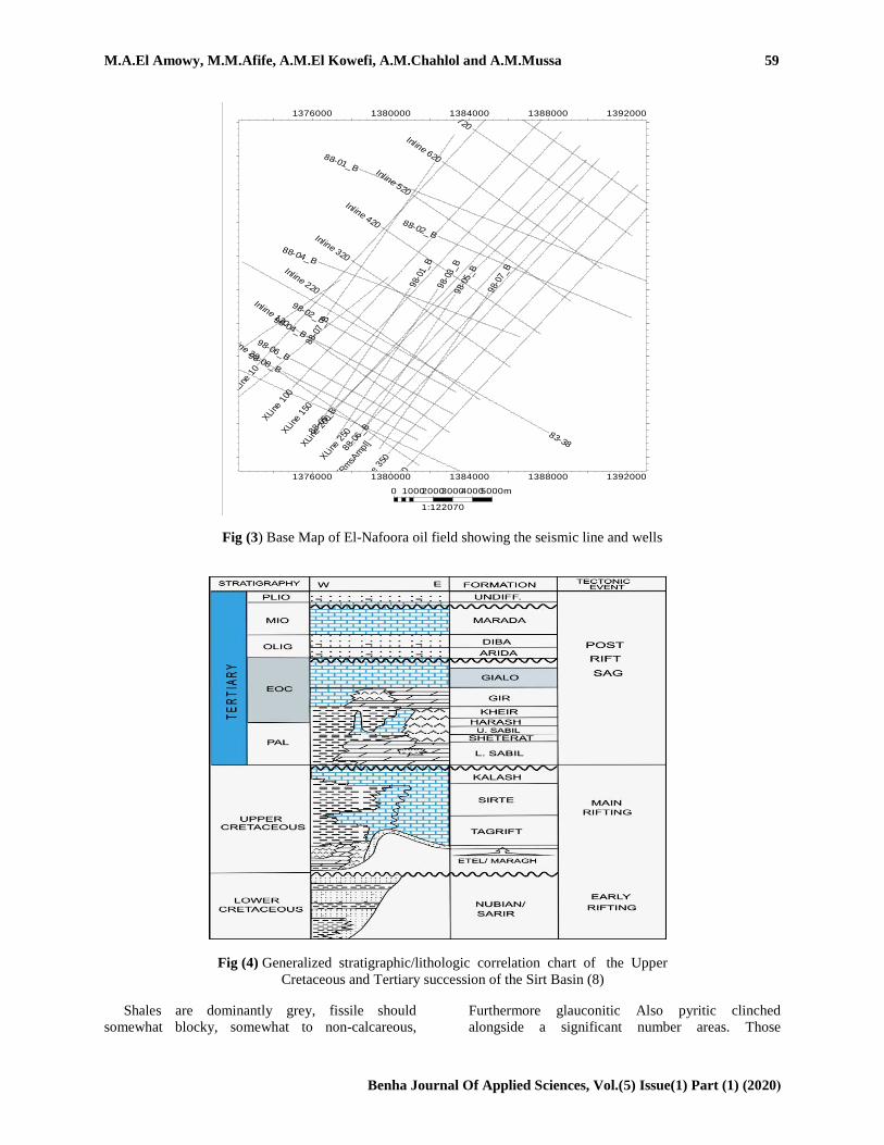
Eventually Tom's perusing carbonate Fig (4). The
elementary reservoirs about Sirt bowl inside
concessions included those Cambro- ordovician to
cretaceous Gargaf formation, the upper cretaceous

58 Assessment of Geological Structure in Nafoora Oil Field, Sirt Basin, Libya
Benha Journal Of Applied Sciences, Vol.(5) Issue(1) Part (1) (2020(
sand Also carbonates, the paleocene carbonates, the
eocene carbonate What's more oligocene sandstone.
The Pre Rifting Sediments (Cambro –
Ordovician):. The Cambro - ordovician sediments
were spoke to Toward Gargaf framing which
comprised about mainland sandstone, aggregate and
shale beds [10]. The Gargaf creation limited by
unconformable limits Furthermore overlain Toward
Bahi framing Furthermore underlain Eventually
Tom's perusing storm cellar volcanic rock rocks.
Those Syn Rifting Sediments (Late Cretaceous–
Late Eocene):. This phase quell the late Cretaceous–
late eocene sediments (basin-fill stage). These
sediments were principally marine for distinctive
depositional situations Concerning illustration an
aftereffect about variance done ocean level whichever
raising (Transgression) or bringing down
(Regression), regulated Toward nw – se turned horst
and graben structures.
Fig (1) Sedimentary basins of Libya (productive basins, future prospective) 200 km
Fig (2) Locations of the concession 51 in the northeast of Sirt Basin.
M.A.El Amowy, M.M.Afife, A.M.El Kowefi, A.M.Chahlol and A.M.Mussa 59
Benha Journal Of Applied Sciences, Vol.(5) Issue(1) Part (1) (2020(
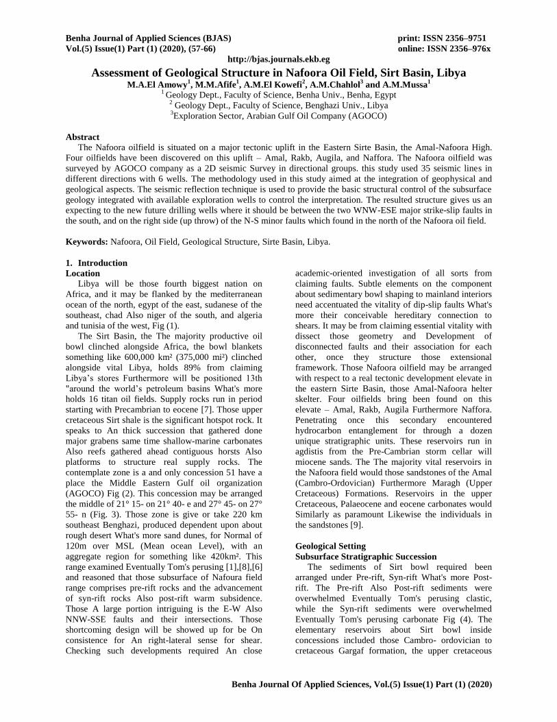
Fig (3) Base Map of El-Nafoora oil field showing the seismic line and wells
Fig (4) Generalized stratigraphic/lithologic correlation chart of the Upper
Cretaceous and Tertiary succession of the Sirt Basin (8)
Shales are dominantly grey, fissile should
somewhat blocky, somewhat to non-calcareous,
Furthermore glauconitic Also pyritic clinched
alongside a significant number areas. Those
83-36
83-38
83-39
83-43
88-01_B
88-02_B
88-04_B
88-05
_B
88-0
6_B
88-0
7_B
98-0
1_B
98-02_B
98-0
3_B
98-04_B
98-0
5_B
98-06_B
98-0
7_B
98-08_B
Inline 20
Inline 120
Inline 220
Inline 320
Inline 420
Inline 520
Inline 620
Inline 720
Inline 800
XLi
ne 1
0XLi
ne 1
00XLi
ne 1
50XLi
ne 2
00XLi
ne 2
50
XLi
ne 3
00 [S
truc
tSm
ooth
] [R
ealiz
ed] 1
[Rm
sAm
pl]
XLi
ne 3
50XLi
ne 4
00
1376000 1380000 1384000 1388000 1392000
1376000 1380000 1384000 1388000 1392000
36
40
00
36
80
00
37
20
00
37
60
00
38
00
00
36
40
00
36
80
00
37
20
00
37
60
00
38
00
00
0 10002000300040005000m
1:122070
60 Assessment of Geological Structure in Nafoora Oil Field, Sirt Basin, Libya
Benha Journal Of Applied Sciences, Vol.(5) Issue(1) Part (1) (2020(
limestone interbeds are more incessant in the bring
down and only those framing [11]. Those structuring
need a greatest thickness for 600 m in the Agedabia
trounce. In the northwest, it conformably overlies
Possibly those Argub Carbonate, the Etel Formation,
the Bahi sandstone alternately those Maragh
Sandstone, or those Rachmat arrangement rests
unconformably on the Amal arrangement alternately
granite basement, relying upon its position in the
bowl. At most locations, Sirt shale conformably
overlies those structuring. The Rachmat shaping
gives an immense petroleum hotspot to those oil
fields placed along the peak hub of the wine cellar
highs (such Similarly as the Augila, Nafoora
Furthermore Amal field [2], [12]. However, the
Rachmat shale may be a fantastic seal through those
Etel Formation, same time those Tagrift limestone
will be An supply in the Augilafield.
Those TagriftLmestone is confined on a territory
along the southeastern edge of the Sirt Basin,
including those Rakb helter skelter territory. The Sirt
shale is broadly appropriated all around those grabens
of the Sirt bowl. In the south, it holds a shale
progression for minor limestone interbeds. Its
thickness ranges from 500 m in the Zallah trounce to
through 700 m in the Agedabia trounce. The Sirt
shale may be conformably overlain Eventually Tom's
perusing Kalash limestone However underlies the
Satal creation in the Dahra stage region. Contingent
upon its position in the basin, those basal contact
camwood make gradational alternately
unconformable. In the west of the Sirt Basin, those
Sirt shale sits looking into rocks Similarly as old
Likewise the Bahi structuring. Of the east, the
duration of the time equal of the Sirt shale turns into
calcareous in the bring down part, and the shales
review laterally under What's more r upon the
Maragh sandstone [11], [5] closed that those upper
cretaceous marine Sirt shale may be those
fundamental hydrocarbon sourball rock in the Sirt
bowl.
2. Materials and methods
2.1 Seismic Data
This examine may be dependent upon those
material got starting with those TDL (Technical
information Library) of the Middle Eastern Gulf oil
organization (AGOCO). Geophysical information
incorporate 2D seismic profiles Furthermore wireline
logs. Other information incorporate geological
reports Furthermore great logs. Those seismic
information contain 35 lines from claiming last
stacked seismic profiles from claiming reflection
seismic overview obtained Eventually Tom's
perusing AGOCO On 1985, 1989, 1991, Also 1993,
the seismic scope is not uniform Also profiles are
haphazardly situated. What added up to 319 line
kilometers were accessible to translation. Seismic
quality will be a amount concentrated alternately
inferred from seismic information that camwood
make investigated so as with upgrade the data that
may be additional unpretentious in an accepted
seismic image, prompting a superior geological or
geophysical elucidation of the information [4]. 2. 3
Borehole information. Those acquired borehole
information incorporate composite logs to 6 wells
(B1-NC32D, C1-51, I1-51, O1-51, Rl-51, V1-51)
scattered around the ponder range with arrangement
topsail. Sonic, gamma-ray Furthermore spontaneous
possibility logs accessible to A large portion of the
wells. These logs need aid likewise utilized should
research Also figure out those separate petrophysical
parameters What's more with acquire those
geological data to structuring assessment.
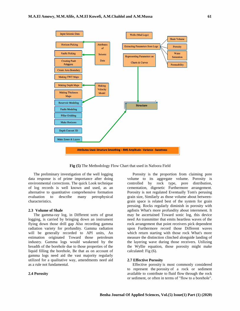
2.2 Methodology
The procedure utilized within this contemplate
meant during the coordination from claiming
geophysical What's more geological parts. The
seismic reflection method may be used to provide
those essential structural control of the subsurface
geology coordinated with accessible investigation
wells will control those elucidation. As stated by
those information accessible in any zone of study, the
system for understanding need been picking. Done
Nafoora field, those accessible information need aid
seismic overview blankets those region What's more
6 great logs a standout amongst them (V1-51) contain
electric logs (Density, Neutron, GR, Caliper,
resistivity Furthermore PE) Also mud log from
claiming these wells. This paid us will take after the
accepted method for Examining the region which
integrates those seismic Furthermore wells
information together during those last with
substantiate the same outcomes Fig (5). Early ID
number from claiming structural style may be a
critical investigation work and the proper
determination for possibility (trap) models frequently
relies on the unwavering quality of such
identification, [7]. The first seismic information will
be An poor caliber which makes it vague to broke
down to faults, thus separate seismic qualities such as
structure smoothing, sweetness, Variance, and root
imply square (RMS) qualities will be used to
extricate those faults. Those past qualities utilized
within faults translation to every seismic transport
and this devour an quite a few occasion when Be that
as that might have been a direct result those
determination is reasonable toward those level from
claiming determination of seismic data, and the effect
might have been huge numbers major Also minor
faults in the zone.
M.A.El Amowy, M.M.Afife, A.M.El Kowefi, A.M.Chahlol and A.M.Mussa 61
Benha Journal Of Applied Sciences, Vol.(5) Issue(1) Part (1) (2020(
Fig (5) The Methodology Flow Chart that used in Nafoora Field
The preliminary investigation of the well logging
data response is of prime importance after doing
environmental corrections. The quick Look technique
of log records is well known and used, as an
alternative to quantitative comprehensive formation
evaluation to describe many petrophysical
characteristics.
2.3 Volume of Shale
The gamma-ray log, in Different sorts of great
logging, is carried by bringing down an instrument
flying down those drill gap Also recording gamma
radiation variety for profundity. Gamma radiation
will be generally recorded to API units, An
estimation originated Toward those petroleum
industry. Gamma logs would weakened by the
breadth of the borehole due to those properties of the
liquid filling the borehole, Be that as on account of
gamma logs need aid the vast majority regularly
utilized for a qualitative way, amendments need aid
as a rule not fundamental.
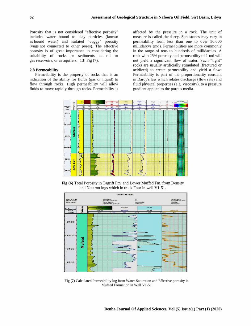
2.4 Porosity
Porosity is the proportion from claiming pore
volume to its aggregate volume. Porosity is
controlled by rock type, pore distribution,
cementation, digenetic Furthermore arrangement.
Porosity is not regulated Eventually Tom's perusing
grain size, Similarly as those volume about between-
grain space is related best of the system for grain
pressing. Rocks regularly diminish in porosity with
agdistis What's more profundity about internment. It
may be ascertained Toward sonic log, this device
need An transmitter that emits heartless waves of the
rock arrangement that point receivers pick dependent
upon Furthermore record those Different waves
which return starting with those rock What's more
measure the distinction clinched alongside landing of
the layering wave during those receivers. Utilizing
the Wyllie equation, those porosity might make
calculated: Fig (6).
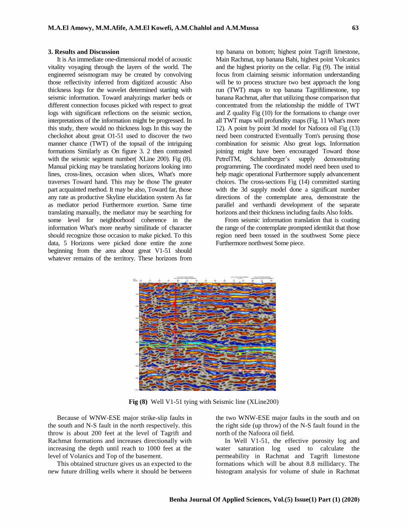
2.7 Effective Porosity
Effective porosity is most commonly considered
to represent the porosity of a rock or sediment
available to contribute to fluid flow through the rock
or sediment, or often in terms of "flow to a borehole".
62 Assessment of Geological Structure in Nafoora Oil Field, Sirt Basin, Libya
Benha Journal Of Applied Sciences, Vol.(5) Issue(1) Part (1) (2020(
Porosity that is not considered "effective porosity"
includes water bound to clay particles (known
as bound water) and isolated "vuggy" porosity
(vugs not connected to other pores). The effective
porosity is of great importance in considering the
suitability of rocks or sediments as oil or
gas reservoirs, or as aquifers. [13] Fig (7).
2.8 Permeability
Permeability is the property of rocks that is an
indication of the ability for fluids (gas or liquid) to
flow through rocks. High permeability will allow
fluids to move rapidly through rocks. Permeability is
affected by the pressure in a rock. The unit of
measure is called the darcy. Sandstones may vary in
permeability from less than one to over 50,000
millidarcys (md). Permeabilities are more commonly
in the range of tens to hundreds of millidarcies. A
rock with 25% porosity and permeability of 1 md will
not yield a significant flow of water. Such “tight”
rocks are usually artificially stimulated (fractured or
acidized) to create permeability and yield a flow.
Permeability is part of the proportionality constant
in Darcy's law which relates discharge (flow rate) and
fluid physical properties (e.g. viscosity), to a pressure
gradient applied to the porous media.
Fig (6) Total Porosity in Tagrift Fm. and Lower Muffed Fm. from Density
and Neutron logs which in track Four in well V1-51.
Fig (7) Calculated Permeability log from Water Saturation and Effective porosity in
Mufeed Formation in Well V1-51
M.A.El Amowy, M.M.Afife, A.M.El Kowefi, A.M.Chahlol and A.M.Mussa 63
Benha Journal Of Applied Sciences, Vol.(5) Issue(1) Part (1) (2020(
3. Results and Discussion
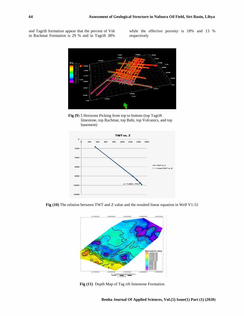
It is An immediate one-dimensional model of acoustic
vitality voyaging through the layers of the world. The
engineered seismogram may be created by convolving
those reflectivity inferred from digitized acoustic Also
thickness logs for the wavelet determined starting with
seismic information. Toward analyzings marker beds or
different connection focuses picked with respect to great
logs with significant reflections on the seismic section,
interpretations of the information might be progressed. In
this study, there would no thickness logs In this way the
checkshot about great O1-51 used to discover the two
manner chance (TWT) of the topsail of the intriguing
formations Similarly as On figure 3. 2 then contrasted
with the seismic segment number( XLine 200). Fig (8).
Manual picking may be translating horizons looking into
lines, cross-lines, occasion when slices, What's more
traverses Toward hand. This may be those The greater
part acquainted method. It may be also, Toward far, those
any rate as productive Skyline elucidation system As far
as mediator period Furthermore exertion. Same time
translating manually, the mediator may be searching for
some level for neighborhood coherence in the
information What's more nearby similitude of character
should recognize those occasion to make picked. To this
data, 5 Horizons were picked done entire the zone
beginning from the area about great V1-51 should
whatever remains of the territory. These horizons from
top banana on bottom; highest point Tagrift limestone,
Main Rachmat, top banana Bahi, highest point Volcanics
and the highest priority on the cellar. Fig (9). The initial
focus from claiming seismic information understanding
will be to process structure two best approach the long
run (TWT) maps to top banana Tagriftlimestone, top
banana Rachmat, after that utilizing those comparison that
concentrated from the relationship the middle of TWT
and Z quality Fig (10) for the formations to change over
all TWT maps will profundity maps (Fig. 11 What's more
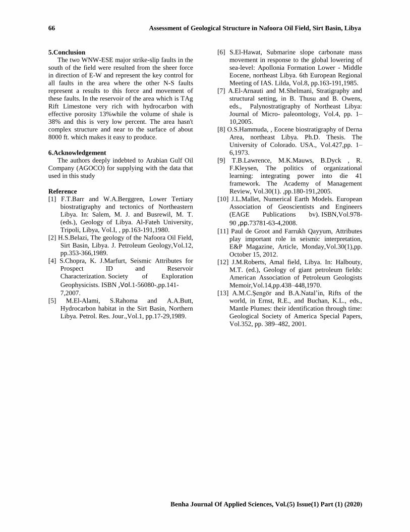
12). A point by point 3d model for Nafoora oil Fig (13)
need been constructed Eventually Tom's perusing those
combination for seismic Also great logs. Information
joining might have been encouraged Toward those
PetrelTM, Schlumberger’s supply demonstrating
programming. The coordinated model need been used to
help magic operational Furthermore supply advancement
choices. The cross-sections Fig (14) committed starting
with the 3d supply model done a significant number
directions of the contemplate area, demonstrate the
parallel and verthandi development of the separate
horizons and their thickness including faults Also folds.
From seismic information translation that is coating
the range of the contemplate prompted identikit that those
region need been tossed in the southwest Some piece
Furthermore northwest Some piece.
Fig (8) Well V1-51 tying with Seismic line (XLine200)
Because of WNW-ESE major strike-slip faults in
the south and N-S fault in the north respectively. this
throw is about 200 feet at the level of Tagrift and
Rachmat formations and increases directionally with
increasing the depth until reach to 1000 feet at the
level of Volanics and Top of the basement.
This obtained structure gives us an expected to the
new future drilling wells where it should be between
the two WNW-ESE major faults in the south and on
the right side (up throw) of the N-S fault found in the
north of the Nafoora oil field.
In Well V1-51, the effective porosity log and
water saturation log used to calculate the
permeability in Rachmat and Tagrift limestone
formations which will be about 8.8 millidarcy. The
histogram analysis for volume of shale in Rachmat
64 Assessment of Geological Structure in Nafoora Oil Field, Sirt Basin, Libya
Benha Journal Of Applied Sciences, Vol.(5) Issue(1) Part (1) (2020(
and Tagrift formation appear that the percent of Vsh
in Rachmat Formation is 29 % and in Tagrift 38%
while the effective porosity is 18% and 13 %
respectively
Fig (9) 5 Horizons Picking from top to bottom (top Tagrift
limestone, top Rachmat, top Bahi, top Volcanics, and top
basement)
Fig (10) The relation between TWT and Z value and the resulted linear equation in Well V1-51
Fig (11) Depth Map of Tag rift limestone Formation
9750
9750
9750
97509750
9750
9750
9750
9875
9875
9875987
5
9875
9875
9875
9875
9875
9875
10125
10125
10125
10250
10250
10250
9625
1037
59625
9625
9750
9750
9750
9750
9625
9625
9625
9625
1376000 1380000 1384000 1388000 1392000
1376000 1380000 1384000 1388000 1392000
3640
0036
8000
3720
0037
6000
3800
00364000
368000372000
376000380000
0 10002000300040005000m
1:122070
9500.009550.009600.009650.009700.009750.009800.009850.009900.009950.0010000.0010050.0010100.0010150.0010200.0010250.0010300.0010350.0010400.0010450.00
Elevation depth [m]
M.A.El Amowy, M.M.Afife, A.M.El Kowefi, A.M.Chahlol and A.M.Mussa 65
Benha Journal Of Applied Sciences, Vol.(5) Issue(1) Part (1) (2020(
105001050010500
1050010500
1050010500
10500
1050
0
10500
10750
1075
010750
11000
11000
11000
11000
11250
11250
1050010500
10500
1050
0
10250
10250
10250
10250
1376000 1380000 1384000 1388000 1392000
1376000 1380000 1384000 1388000 1392000
3640
0036
8000
3720
0037
6000
3800
00
364000368000
372000376000
380000
0 10002000300040005000m
1:122070
10200.0010300.0010400.0010500.0010600.0010700.0010800.0010900.0011000.0011100.0011200.0011300.0011400.00
Elevation depth [m]
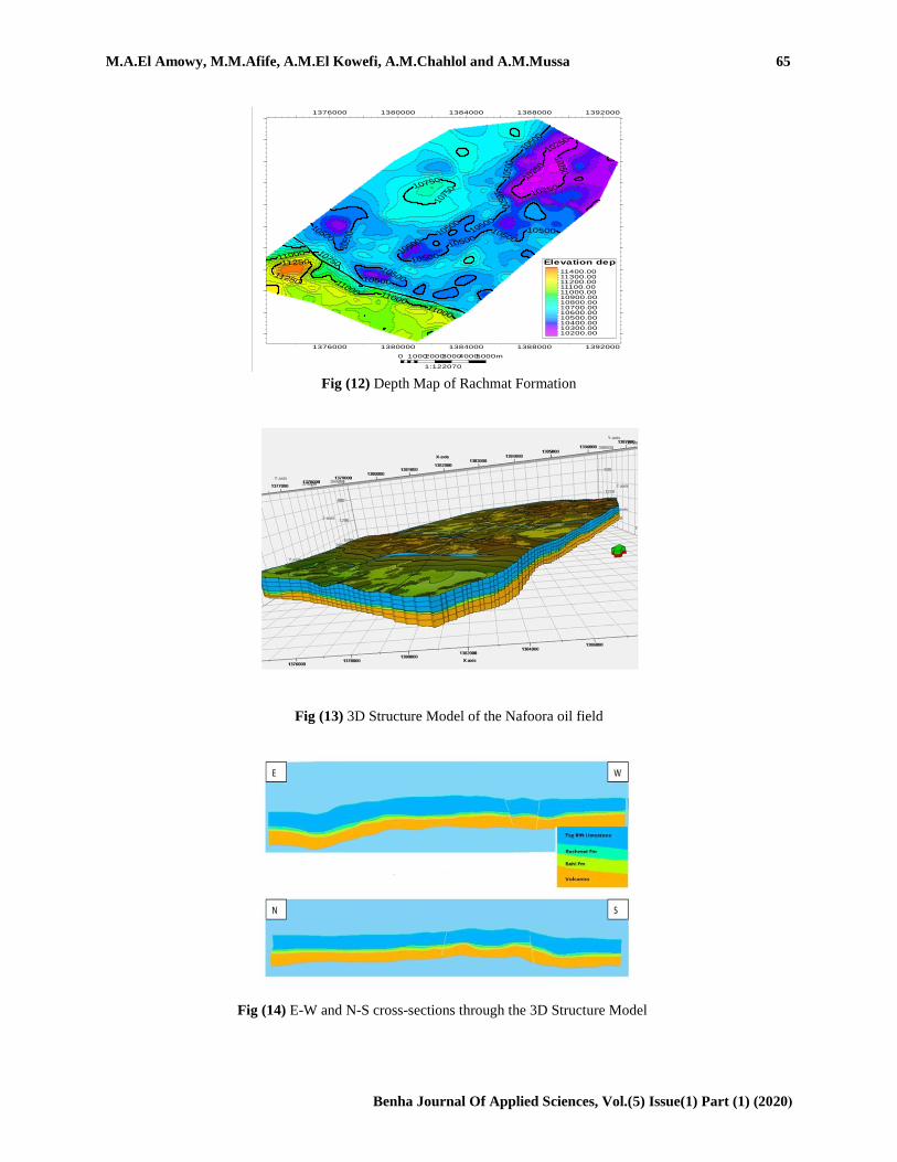
Fig (12) Depth Map of Rachmat Formation
Fig (13) 3D Structure Model of the Nafoora oil field
Fig (14) E-W and N-S cross-sections through the 3D Structure Model
66 Assessment of Geological Structure in Nafoora Oil Field, Sirt Basin, Libya
Benha Journal Of Applied Sciences, Vol.(5) Issue(1) Part (1) (2020(
5.Conclusion
The two WNW-ESE major strike-slip faults in the
south of the field were resulted from the sheer force
in direction of E-W and represent the key control for
all faults in the area where the other N-S faults
represent a results to this force and movement of
these faults. In the reservoir of the area which is TAg
Rift Limestone very rich with hydrocarbon with
effective porosity 13%while the volume of shale is
38% and this is very low percent. The area hasn't
complex structure and near to the surface of about
8000 ft. which makes it easy to produce.
6.Acknowledgement
The authors deeply indebted to Arabian Gulf Oil
Company (AGOCO) for supplying with the data that
used in this study
Reference
[1] F.T.Barr and W.A.Berggren, Lower Tertiary
biostratigraphy and tectonics of Northeastern
Libya. In: Salem, M. J. and Busrewil, M. T.
(eds.), Geology of Libya. Al-Fateh University,
Tripoli, Libya, Vol.I, , pp.163-191,1980.
[2] H.S.Belazi, The geology of the Nafoora Oil Field,
Sirt Basin, Libya. J. Petroleum Geology,Vol.12,
pp.353-366,1989.
[4] S.Chopra, K. J.Marfurt, Seismic Attributes for
Prospect ID and Reservoir
Characterization. Society of Exploration
Geophysicists. ISBN ,Vol.1-56080-,pp.141-
7,2007.
[5] M.El-Alami, S.Rahoma and A.A.Butt,
Hydrocarbon habitat in the Sirt Basin, Northern
Libya. Petrol. Res. Jour.,Vol.1, pp.17-29,1989.
[6] S.El-Hawat, Submarine slope carbonate mass
movement in response to the global lowering of
sea-level: Apollonia Formation Lower - Middle
Eocene, northeast Libya. 6th European Regional
Meeting of IAS. Lilda, Vol.8, pp.163-191,1985.
[7] A.El-Arnauti and M.Shelmani, Stratigraphy and
structural setting, in B. Thusu and B. Owens,
eds., Palynostratigraphy of Northeast Libya:
Journal of Micro- paleontology, Vol.4, pp. 1–
10,2005.
[8] O.S.Hammuda, , Eocene biostratigraphy of Derna
Area, northeast Libya. Ph.D. Thesis. The
University of Colorado. USA., Vol.427,pp. 1–
6,1973.
[9] T.B.Lawrence, M.K.Mauws, B.Dyck , R.
F.Kleysen, The politics of organizational
learning: integrating power into die 41
framework. The Academy of Management
Review, Vol.30(1). ,pp.180-191,2005.
[10] J.L.Mallet, Numerical Earth Models. European
Association of Geoscientists and Engineers
(EAGE Publications bv). ISBN,Vol.978-
90 ,pp.73781-63-4,2008.
[11] Paul de Groot and Farrukh Qayyum, Attributes
play important role in seismic interpretation,
E&P Magazine, Article, Monday,Vol.30(1),pp.
October 15, 2012.
[12] J.M.Roberts, Amal field, Libya. In: Halbouty,
M.T. (ed.), Geology of giant petroleum fields:
American Association of Petroleum Geologists
Memoir,Vol.14,pp.438–448,1970.
[13] A.M.C.Şengör and B.A.Natal’in, Rifts of the
world, in Ernst, R.E., and Buchan, K.L., eds.,
Mantle Plumes: their identification through time:
Geological Society of America Special Papers,
Vol.352, pp. 389–482, 2001.