Embed Size (px)
Citation preview
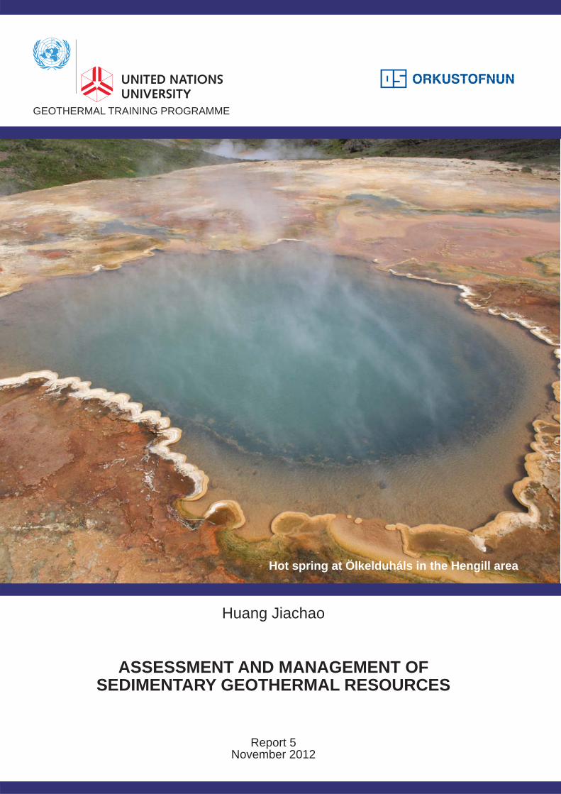
ASSESSMENT AND MANAGEMENT OFSEDIMENTARY GEOTHERMAL RESOURCES
GEOTHERMAL TRAINING PROGRAMME
Huang Jiachao
Report 5November 2012
Hot spring at Ölkelduháls in the Hengill area
GEOTHERMAL TRAINING PROGRAMME Reports 2012 Orkustofnun, Grensásvegur 9, Number 5 IS-108 Reykjavík, Iceland
ASSESSMENT AND MANAGEMENT OF SEDIMENTARY GEOTHERMAL RESOURCES
MSc thesis School of Engineering and Natural Sciences
Faculty of Earth Sciences University of Iceland
by
Huang Jiachao Shaanxi Green Energy Geothermal Development Co. Ltd.
No. 10 Biyuan Road, 712000 Xianyang, Shaanxi Province
P.R. CHINA [email protected]
United Nations University Geothermal Training Programme
Reykjavík, Iceland Published in November 2012
ISBN 978-9979-68-324-7
ISSN 1670-7427

ii
This MSc thesis has also been published in May 2012 by the School of Engineering and Natural Sciences
Faculty of Earth Sciences University of Iceland
iii
INTRODUCTION
The Geothermal Training Programme of the United Nations University (UNU) has operated in Iceland since 1979 with six month annual courses for professionals from developing countries. The aim is to assist developing countries with significant geothermal potential to build up groups of specialists that cover most aspects of geothermal exploration and development. During 1979-2012, 515 scientists and engineers from 53 developing countries have completed the six month courses. They have come from Asia (40%), Africa (32%), Central America (16%), Central and Eastern Europe (12%), and Oceania (0.4%) There is a steady flow of requests from all over the world for the six month training and we can only meet a portion of the requests. Most of the trainees are awarded UNU Fellowships financed by the UNU and the Government of Iceland. Candidates for the six month specialized training must have at least a BSc degree and a minimum of one year practical experience in geothermal work in their home countries prior to the training. Many of our trainees have already completed their MSc or PhD degrees when they come to Iceland, but several excellent students who have only BSc degrees have made requests to come again to Iceland for a higher academic degree. In 1999, it was decided to start admitting UNU Fellows to continue their studies and study for MSc degrees in geothermal science or engineering in co-operation with the University of Iceland. An agreement to this effect was signed with the University of Iceland. The six month studies at the UNU Geothermal Training Programme form a part of the graduate programme.
It is a pleasure to introduce the 32nd UNU Fellow to complete the MSc studies at the University of Iceland under the co-operation agreement. Huang Jiachao, BSc in Hydrogeology of the Shaanxi Green Energy Geothermal Development Co. Ltd., completed the six month specialized training in Reservoir Engineering at the UNU Geothermal Training Programme in October 2009. His research report was entitled: “Assessment of geothermal resources in Xianyang, Shaanxi Province, China: Lumped parameter modelling and predictions”. After one year of geothermal research work in China, he came back to Iceland for MSc studies at the Faculty of Earth Sciences of the University of Iceland in August 2010. In May 2012, he defended his MSc thesis presented here, entitled “Assessment and management of sedimentary geothermal resources”. His studies in Iceland were financed by the Government of Iceland through a UNU-GTP Fellowship from the UNU Geothermal Training Programme. We congratulate him on his achievements and wish him all the best for the future. We thank the Faculty of Earth Sciences at the School of Engineering and Natural Sciences of the University of Iceland for the co-operation, and his supervisors for the dedication. Finally, I would like to mention that Jiachao’s MSc thesis with the figures in colour is available for downloading on our website www.unugtp.is under publications.
With warmest wishes from Iceland,
Ingvar B. Fridleifsson, director United Nations University Geothermal Training Programme
iv
ACKNOWLEDGEMENTS
I would like to express my gratitude to United Nations University Geothermal Training Programme (UNU-GTP) for awarding me a UNU-GTP Fellowship to support my study in Iceland. I am very grateful to Dr. Ingvar Birgir Fridleifsson, the director of UNU-GTP, and Mr. Lúdvík S. Georgsson, the deputy director of UNU-GTP, for giving me the opportunity to attend the master’s program. I would also like to thank the staff of UNU-GTP, Thórhildur Ísberg, Markús A.G. Wilde, Ingimar G. Haraldsson and Málfrídur Ómarsdóttir for their assistance and advice during my stay in Iceland. My special appreciation goes to Gudni Axelsson, my adviser, for his patient instruction, considerable help and friendliness during my work for the master’s programme. I also want to give my grateful thanks to the professors and schoolmates in University of Iceland for their great help through their teaching and valuable discussions. The staff of Orkustofnun and ÍSOR also gave me plentiful help during every stage of my study. I am also grateful to the other postgraduate fellows of the UNU-GTP for sharing their knowledge and experience in their research fields. I wish to express my sincere gratitude to my company, Shaanxi Green Energy Geothermal Development Co. Ltd., and all my co-workers there, for supporting me to accomplish this master programme. In addition, special thanks to Sun Caixia, Jing Yang, Shi Sha and Li Xiaojun for supplying data for this thesis.
v
ABSTRACT Low-temperature (<150°C) sedimentary geothermal resources are widespread in the continental regions of the Earth’s crust. They are quite different in nature from the geothermal resources associated with volcanic systems or tectonically active regions of the crust. Their management during long-term utilization also requires somewhat different emphasis than that of the conventional geothermal resources. Good examples of sedimentary resources, which have been utilized heavily for direct applications, can be found in France, Hungary and China. More than 3500 geothermal wells had been drilled in China by 2010, most of them in sedimentary geothermal systems. Two Chinese sedimentary geothermal systems, the Xianyang system in Shaanxi and the Xiongxian system in Hebei Province have been assessed by lumped parameter pressure response modelling and volumetric calculations. They are of quite contrasting nature, the Xianyang system being a porous-type sandstone system and the Xiongxian system being a fissured-karst carbonate rock system. Xianyang lies in Wei River sedimentary basin in the centre of China. Today over 40 geothermal wells, ranging in depth from about 1500 to 4100 m, are distributed through the region. Well head temperature ranges from 55 to 120°C. Geothermal space heating is the main consumption in Xianyang with up to 3 million m2 approximately being heated, which is equivalent to reducing CO2 emission annually by 120,000 tons by replacing conventional coal boilers. The average permeability-thickness of the Xianyang reservoir is estimated to range from 2 to 36 Darcy-m through the lumped parameter modelling. Permeability inside the Xianyang reservoir increases northwards as well as indicating a significant difference between the two sides of the Wei River Northern Bank Fault. The Xianyang sandstone reservoir appears to approach a closed reservoir in nature. The volume of geothermal fluid stored underground in the Xianyang territory is estimated to be 59·109 m3 and recoverable heat to be 13·1018 J. Xiongxian lies in the North China Basin at about 110 km and 100 km from Beijing and Tianjin, respectively. Over 56 geothermal wells (including 8 reinjection wells), which are mostly used for space heating, had been drilled by 2010. The Xiongxian reservoir is relatively shallow, with the deepest well being 1800 m, and the reservoir temperature ranging from 50 to 95°C. Large scale reinjection started in Xiongxian in 2009. The internal permeability-thickness of the Jixian reservoir in Xiongxian is estimated to be up to 95 Darcy-m, and the external permeability over 14 Darcy-m, according to the lumped parameter modelling conducted. The potential of the Jixian reservoir is rather promising for future exploitation, partly because reinjection should be easy. The pressure response of the Jixian reservoir is comparable to that of an open reservoir. The volume of geothermal fluid stored in the Jixian reservoir, in the Xiongxian territory, is estimated to equal 9.6·109 m3 and the recoverable heat to be 2.5·1018 J. The lumped parameter models for the respective systems are used to calculate reservoir pressure predictions for different future production scenarios. Recommendations on the management of sedimentary geothermal resources in China, based on experience gathered in China and on mainland Europe, as well as on the results of the assessments of the work presented, are also provided. The most important ones relate to common management, enhanced monitoring and reinjection.
vi
TABLE OF CONTENTS Page 1. INTRODUCTION ......................................................................................................................... 1 2. UTILIZATION OF SEDIMENTARY GEOTHERMAL SYSTEMS WORLDWIDE ................. 3 2.1 General ................................................................................................................................. 3 2.2 Europe .................................................................................................................................. 3 2.2.1 Pannonian Basin in SE-Hungary .......................................................................... 3 2.2.2 Sandstone reinjection in N-German Basin ........................................................... 4 2.2.3 Paris Basin, France ............................................................................................... 4 2.3 China .................................................................................................................................... 5 2.3.1 North China Basin ................................................................................................ 6 2.3.2 Wei River Basin ................................................................................................... 8 2.3.3 Jianghan Basin ...................................................................................................... 8 3. MODELLING METHODOLOGY ................................................................................................ 9 3.1 Lumped parameter modelling .............................................................................................. 9 3.2 Estimation of reservoir properties ...................................................................................... 10 3.3 Analysis of step-rate well test data .................................................................................... 11 3.4 Water level correction ........................................................................................................ 12 3.5 Geothermal resource assessment with volumetric method ................................................ 13 4. THE XIANYANG CASE STUDY, CHINA ............................................................................... 15 4.1 Case background ................................................................................................................ 15 4.2 Xianyang geothermal system and Wei River sediment basin ............................................ 16 4.3 Pressure, temperature and geochemical information ......................................................... 18 4.4 Analysis of Xianyang well tests ......................................................................................... 20 4.5 Modelling of the Xianyang geothermal system ................................................................. 20 4.5.1 Conceptual reservoir model ................................................................................ 20 4.5.2 Lumped parameter simulation ............................................................................ 22 4.5.3 Estimation of Xianyang reservoir properties ...................................................... 25 4.5.4 Pressure predictions ............................................................................................ 27 4.6 Geothermal resource assessment with volumetric method ................................................ 31 4.7 Role of convection in the Xianyang system ...................................................................... 32 5. THE XIONGXIAN CASE STUDY, CHINA .............................................................................. 34 5.1 Case background ................................................................................................................ 34 5.2 The Xiongxian geothermal system and Niutuozhen Uplift ............................................... 35 5.3 Pressure, temperature and geochemical information ......................................................... 37 5.4 Reinjection ......................................................................................................................... 38 5.5 Modelling of the Xiongxian geothermal system ................................................................ 38 5.5.1 Conceptual model ............................................................................................... 38 5.5.2 Lumped parameter simulation ............................................................................ 39 5.5.3 Estimation of reservoir properties ...................................................................... 40 5.5.4 Water level predictions ....................................................................................... 42 5.6 Geothermal resource assessment with volumetric method ................................................ 43 6. CONCLUSIONS .......................................................................................................................... 46 7. RECOMMENDATIONS FOR MANAGEMENT OF SEDIMENTARY RESOURCE IN CHINA .................................................................................................................................... 48 REFERENCES ....................................................................................................................................... 49
vii
LIST OF FIGURES Page 1. Map showing the distribution of the main geothermal systems in China ...................................... 5 2. Two types of lumped models for hydrological reservoirs ............................................................. 9 3. Three tanks model with two-dimensional flow ........................................................................... 10 4. Sketch demonstrating the water level correction needed for production wells ........................... 13 5. The location of Xianyang and Xiongxian ................................................................................... 15 6. Sub-geological structures in Wei River Basin ............................................................................ 16 7. N-S geological cross-section through Wei River Basin .............................................................. 17 8. Location of geothermal wells in Xianyang City ......................................................................... 18 9. Temperature profiles of several geothermal wells in Xianyang ................................................. 19 10. Approximate production characteristics of wells based on step-rate well test data .................... 21 11. Comparison of observed pressure for well Sanpu1 and pressure simulated ............................... 23 12. Comparison of observed pressure for well Sanpu2 and pressure simulated ............................... 24 13. Comparison of observed water level for well WR3 and water level simulated .......................... 25 14. Comparison between pressure predictions for well Sanpu 2 for prediction scenario 1 .............. 28 15. Comparison between pressure predictions for well Sanpu 2 for prediction scenario 2 .............. 28 16. Comparison between pressure predictions for well Sanpu 2 for prediction scenario 3 .............. 29 17. Comparison between water level predictions for well WR3 for prediction scenario 1 ............... 29 18. Comparison between water level predictions for well WR3 for prediction scenario 2 ............... 30 19. Comparison between water level predictions for well WR3 for prediction scenario 3 ............... 30 20. Location of the the Xiongxian geothermal system with regional tectonic background .............. 34 21. Geological map of the bedrock of the Niutuozhen Uplift ........................................................... 35 22. A geological cross-section (I-I’ in Figure 21) through the Niutuozhen Uplift ........................... 36 23. Temperature logging in couples of days after drill completion in Xiongxian ............................ 37 24. Water level measruements for the well doublet including wells 0901 and 0902 ........................ 38 25. Comparison of observed and calculated water level for the Xiongxian production history ....... 40 26. Comparison of observed and calculated water level for well 0902 ............................................ 41 27. Comparison between water level predictions for Scenario 1 ...................................................... 43 28. Comparison between water level predictions for Scenario 2 ...................................................... 44 29. Comparison between water level predictions for Scenario 3 ...................................................... 44 30. Comparison of water level prediction for different scenarios in Xiongxian ............................... 45 LIST OF TABLES 1. Information on the main geothermal basin in east and central China ............................................ 6 2. Half radius between lumped parameter tanks in two-dimensional flow ...................................... 12 3. Basic information on geothermal wells in Xianyang used in this study ...................................... 22 4. Parameters of the lumped parameter models for well Sanpu1 ..................................................... 23 5. Parameters of the lumped parameter models for well Sanpu2 ..................................................... 24 6. Parameters of the lumped parameter models for well WR3 ........................................................ 25 7. Physical properties of the Xianyang reservoir ............................................................................. 26 8. Reservoir properties of the Xianyang reservoir based on the lumped parameter models ............ 26 9. Scenarios used to predict pressure changes in the Xianyang geothermal reservoir ..................... 27 10. Parameters used for a volumetric resource assessment for theXianyang geothermal reservoir ... 31 11. Result of volumetric geothermal assessment for Xianyang ......................................................... 32 12. Parameters of the onset of convection in the Xianyang geothermal system ................................ 33 13. Parameters of the model used to simulate the Xiongxian history data ........................................ 40 14. Parameters of the lumped parameter model for well 0902 in Xionxiong .................................... 41 15. Physical properties of the Xiongxian reservoir ............................................................................ 42 16. Reservoir parameters of the Xiongxian reservoir based on lumped parameter models ............... 42 17. Scenarios for water level predictions Xiongxian ......................................................................... 43 18. Parameters for the volumetric assessment of the Xiongxian geothermal reservoir ..................... 45 19. Result of the geothermal resource assessment for Xiongxian ...................................................... 45

viii
1
1. INTRODUCTION Volcanic geothermal systems characterised with high temperature contain high-quality energy, but their distribution is subject to geographical limits. This would make the wide usage of geothermal energy restricted throughout the world. However, sedimentary geothermal systems are widely spread in most regions of the world, where most of the world population and economic activities are distributed. This combination makes the utilization of geothermal energy worldwide possible and benefits more people. Exploitation and utilization of sedimentary geothermal resources has been widely implemented all over the world, such as in sedimentary structures in the European Lowland and in the Carpathians in Europe, several sedimentary basins in Montana, North Dakota and Texas (USA), the Perth and Otway Basins in Australia as well as the North China and Wei River Basins in China. Geothermal energy in China is mostly exploited from sedimentary geothermal systems. Those characterised with low-medium temperature resources prevail because population and economic activities are mainly distributed in eastern China where low-medium temperature resources are abundant. The modern geothermal exploitation in China started in the early 1970’s although the associated culture and history is over two thousand years old. More than 3500 geothermal wells have been completed in China by 2010 (Kang, 2010). But the ownership of those is decentralized. Geothermal wells in one geothermal reservoir are held by many owners, and most owners hold from one to at most a few wells. This makes the owners more interested in exploitation rather than protection and management of the geothermal resources. However, in the past few years a state-owned Chinese enterprise started concentrated geothermal development, on the geothermal field-wide scale, exclusively to plan and manage geothermal resource utilization. This is Shaanxi Green Energy Geothermal Development Co. Ltd. (SGE) which was established in 2006. It has already set up district space heating networks in Xianyang, Shaanxi Province, and Xiongxian, Hebei Province. Xianyang lies in the Wei River Basin in the centre of China. The prefecture-level division of Xianyang has 5 million inhabitants and its metropolitan area has around 600,000 inhabitants. Today over 40 geothermal wells, ranging in depth from about 1500 to 4100 m, are distributed through the region, with production temperature ranging from 55 to 120°C. Geothermal space heating is the main consumption in Xianyang with up to 3 million m2 heated approximately, which is equivalent to reducing 120,000 tons of CO2 emission annually by replacing coal boilers (Huang, 2009). The geothermal reservoir in Xianyang is typical porous water reservoir. It is famous for great total sandstone thickness and high single well production capacity. Xianyang just sits above the Wei River North Bank Fault. This leads to a significant difference of reservoir properties between the two sides of the fault. The geothermal exploitation has lead to a serious decline of reservoir pressure. The wells in the north of, or close to, the fault decline 1.1-2.8 m/yr. But those in the south part of Xianyang, close to the centre of the Wei River Basin, decline more than 5 m/yr, and some extreme cases even drop down more than 10 m/yr. A long residence time of the geothermal water, from several thousand to 30 thousand years, implies a high mineralization and a relatively closed reservoir (Qin et al., 2005a). Quartz and Na/K geothermometers suggest subsurface temperature is in the range of 76-118°C and most samples show a scaling potential for calcite and magnesium silicates, especially if heated (Wang, 2006). The average measured heat flux from the crust in Xianyang is 71.6 mW/m2. The overall geothermal gradient is in the range of 3.2-3.7°C/100m in the basin, but a granite rock mass of over 8000 km2 in area, which contains radioactive isotopes and underlies the west part of the Wei River Basin, constitutes an extra heat resource for the basin (Chen, 1977). Xiongxian lies in the North China Basin where around a half of all geothermal wells of China are drilled. It is at a distance of 108 km from Beijing and 100 km from Tianjin. The Xiongxian geothermal reservoir is a typical fissured, karst reservoir. It is relatively shallow with the deepest geothermal well being 1800 m and the reservoir temperature ranging from 50 to 95°C. The geothermal resource is mostly used for space heating. Geothermal utilization in Xiongxian began in the 1970s and over 56 geothermal wells (including 8 reinjection wells) have been drilled by 2010. Among them around 20 geothermal wells (including reinjection wells) were drilled in 2009-2011. Well head pressure has dropped from 10 m water head above ground in the 1970’s to about 70 m below surface now.
2
However, geothermal reinjection started in 2009 in the Xiongxian geothermal field. All fluid extracted from newly drilled geothermal wells has to be injected since 2009. Besides that some old production wells have been matched with new reinjection wells or have been switched to being reinjection wells. Full reinjection has been implemented just under the action of gravity on the fluid itself, without any pressure on wellhead. Carbon and oxygen isotope research demonstrates that recharge of geothermal fluid in Xiongxian originates from precipitation with the direction of runoff being from northeast towards southwest (Ma et al., 1990). The purpose of the research described in this thesis is to assess the main reservoir characteristics and most appropriate utilization modes for sedimentary geothermal reservoirs such as the ones in Xianyang and Xiongxian. The thesis starts out by reviewing the utilization experience of sedimentary geothermal resources in several locations worldwide. Lumped parameter models of the Xianyang and Xiongxian geothermal systems are set up (using the LUMPFIT software) to simulate pressure changes in the systems caused by long-term production, based on the local geological information, respectively. Then the production potential and pressure changes in the future of the two reservoirs are estimated. Data for three wells, which are located in different geological structures of Xianyang geothermal system, are selected as representative for the modelling. Thus, reservoir characteristic of different structures of the reservoir can be distinguished. A long production history data-series for the whole Xiongxian territory is also analysed in the report. Three scenarios for different reinjection rates are set up for that system to estimate and compare the future water level changes. Some important properties of the reservoirs, such as size and permeability, are estimated based on the parameters of the simulation models. Volumetric geothermal resource assessment of the two geothermal systems is carried out as well, to complement the pressure modelling results. Finally, conclusions on the properties of the two reservoirs (open/closed) are presented. Through such analysis the comparison of the two types of reservoirs (porous reservoir vs. fissured-karst reservoir) gets clearer. In addition, the role of Wei River North Bank Fault and thermal diffusion (convection/conduction) in the Xianyang geothermal system will also be discussed. The thesis is completed by presenting some general recommendation on the most appropriate management of sedimentary geothermal resources during long-term utilization.
3
2. UTILIZATION OF SEDIMENTARY GEOTHERMAL SYSTEMS WORLDWIDE 2.1 General Sedimentary geothermal systems are widely spread in most regions of the world. This often coincides with regions where most of the world’s population and economic activities are distributed, so that the resources and activity can be joined and utilized by people locally. This is significantly important because primary geothermal energy is not appropriate for long distance transportation. The sedimentary geothermal systems are mostly associated with geological structures such as sedimentary basins. Those are often also rich in oil and gas resources. As a result, many of the world's sedimentary basins have been actively explored for oil and gas so geological knowledge of those basins can also be applied for geothermal investigations and surveying. Typical sedimentary geothermal systems that have been extensively exploited and utilized are mainly found in the Paris Basin in France, the Pannonian Basin in Hungary, the Williston Basin in Montana and North Dakota (USA), The sedimentary system in Texas, the Perth and Otway Basins in Australia as well as the North China and Wei River Basins in China, to name the most prominent examples. Sustainability and efficiency of geothermal exploitation are attracting increasing attention due to the pressure decline in many geothermal reservoirs and the aim of environmentally friendly utilization. Quality management of geothermal systems is therefore highly important. Liu et al. (2010) emphasize that management of geothermal systems involves two main aspects, administrative and technical aspects. Administration measures mainly focus on limiting the amount of production, increasing efficiency and enhancing reinjection. It mainly relies on government and its subsidiary organizations by means of laws, regulations and relevant policies as well as by exploration and exploitation permits and so on. Technical measures include monitoring, reinjection, potential assessments, modelling, etc. Geothermal reinjection is considered as one of the most effective measures available for the realization of sustainability of geothermal utilization. It started as early as 1969 at the Geysers in California and in the Paris Basin, and 1970 in the Ahuachapán field in El Salvador. In China, the earliest geothermal reinjection experiments began in the urban area of Beijing in 1974 and 1975 (Liu et al., 2010). Recently, there are a number of geothermal fields worldwide where reinjection is already an essential part of the field operation, including the Geysers field in the USA, the Larderrello field in Italy, the Berlin field in El Salvador, the Laugaland field in N-Iceland, etc. (Fridleifsson et al., 2008) 2.2 Europe Geothermal energy utilization is implemented in 32 European countries (Kepinska, 2008). Thermal and geological conditions result in the fact that Europe possesses mostly low-enthalpy resources. They are predominantly found in sedimentary formations. The main sedimentary reservoirs that have been developed and exploited in Europe include the Paris Basin in France, the Pannonian Basin which mostly lies in Hungary and partially in its neighbouring countries, European Lowland in North Germany and Poland and some sedimentary geological structures in Carpathians and Alpine Territory. Three of these cases (Pannonian Basin, North German Basin and Paris Basin) are selected and their reservoir characteristics, development and management conditions are presented in the following. 2.2.1 Pannonian Basin in SE-Hungary Geothermal wells have been used in Hungary for over 140 years (Szanyi and Kovács, 2010). The focus is on medium enthalpy systems that supply energy to large municipal district heating and hot water systems, in addition to spa and wellness establishments. An increasing pressure drawdown in the geothermal systems of the Pannonian Basin shows lack of sustainable management and demonstrates that injection is necessary for the management of the geothermal resources.
4
In Hungary, the earth’s continental crust is rather thin (22–26 km) and is covered by low thermal-conductivity formations. These conditions lead to a high geothermal gradient anomaly (approximately 50°C/km) with a heat flow of 90–100 mW/m2. Gravity-driven flow dominates the upper formation and pressure-driven flow dominates the lower sedimentary formations. The porous formations of Pannonian Basin contain water up to 130–150°C; however, the temperature in some karst and fissured carbonated reservoirs in basement rocks is up to 300°C (Szanyi and Kovács, 2010). Rezessy et al. (2005) estimated the total geothermal energy of Hungary stored in formations above 5000 m depth to be approximately 100,000 EJ (1 EJ = 1018 J). To date, over 1400 registered deep wells in Hungary have found thermal water, among them 950 are in production at present, however (Janos and Balazs, 2010). Only about 20 of these are reinjection wells. Fortunately, recent legislation prohibits new geothermal systems from being established without reinjection; only water used for balneotherapy is allowed to be discharged at the surface. The current estimated total production from thermal wells, which are mostly used about 6 months a year, is 84 million m3 per year, with a heat content of 15.2 PJ per year (Szanyi and Kovács, 2010). 2.2.2 Sandstone reinjection in N-German Basin Utilisation of the geothermal energy in the North German Basin began in the early 1980s (Seibt and Wolfgramm, 2008). The first production and reinjection tests from/into sandstone reservoirs started in 1982 and the first heat supply to a residential area in Waren (Müritz) in 1984. More plants were later put into operation in Neubrandenburg, Neustadt-Glewe, Berlin, and Neuruppin. The maximum reinjection flow rate in Neustadt-Glewe is up to 125 m3/h. However, precipitation of iron caused by oxygen entrance and carbonate scaling has been experienced in Neustadt-Glewe. The most serious practical problem encountered during sandstone reinjection is the clogging of the reservoir surrounding reinjection wells. Seibt and Wolfgramm (2008) researched the reason and measures of the clogging. The factors causing the reduced permeability in their paper can be summed up as: mechanical processes of particle entry and rearrangement depending on the flow rate; precipitation reaction of iron due to oxygen entrance; corrosion induced and accelerated by acid fluid, aggressive ions (Cl- etc.) and gases (CO2 and H2S etc.) together with high temperature; bacterial activity that can transfer hydrogen sulphide into sulphide precipitates. Consequently, following measures can be applied to avoid the clogging: control reinjection at an appropriate flow rate; sufficiently filtrate geothermal fluid on surface; add a proper inhibitor; seal reinjection loop to avoid entrance of oxygen whether operating or idle. 2.2.3 Paris Basin, France The Paris Basin is a large sedimentary basin which occupies a vast part of Northern France (110,000 km2) and extends northward below the English Channel, overlying deformed Carboniferous and Permian troughs in between four crystalline basement bodies. The Dogger reservoir (the mid-Jurassic) consisting of carbonate rocks, has been identified as the most promising geothermal development target below the urbanized Paris area. It is recharged along the eastern border of the Paris Basin where the formation outcrops and discharges to the seafloor of the English Channel. In the slow circulation through the basin, the fluid reaches depths of 2000 m where it acquires its geothermal potential (Lopez et al., 2010). Geothermal development in the Paris Basin started in the early 1970s. Since then, the main target has been the Dogger aquifer, and nearly all operations use the “doublet” technology. Of the 55 doublet systems that have been implemented, most of these in the 1980s, 34 are still in operation (Lopez et al., 2010). Geothermal wells are completed with an open hole through the 100-150 m thick Bathonian deposits where the Dogger reservoir is located. The net total productive thickness is of the order of 20 m on average with the permeability in the range of 2-20 Darcy. Formation temperatures at the top of the productive layers are generally between 55 and 80°C. The porosity of overall Bathonian is about 15% on average (Lopez et al., 2010).
5
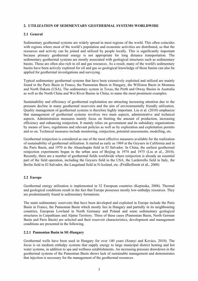
A temperature simulation was done based on data from the Champigny doublet drilled in 1985 (Lopez et al., 2010). It shows that production well temperature will drop 3°C in 46 or 62 years, due to reinjection, when the distance between doublets is 1390 m, exploitation flow rate 270/190m3/h in the winter/summer and production/winter reinjection/summer reinjection temperature 74/40/60°C. However, none of the operating doublets in the area has exhibited any significant temperature decline so far. Another serious difficulty is corrosion and scaling related problems that occurred in many geothermal loops in the mid-1980s. But these phenomena have been satisfactorily controlled by injection of corrosion inhibitors. It is injected into the production well at the level of the casing shoe to protect the entire geothermal loop. 2.3 China The Chinese National Committee of Reserves of Mineral Resources has estimated that the annual exploitable geothermal water (< 2000 m) is about 6800 million m3 per year in terms of the present economic and technical conditions, corresponding to total thermal energy of 970×1015J, which is equivalent to 320 million tons of standard coal (Tao, 2008). The exploitable thermal energy for convection and conduction type reservoirs account for 35% and 65%, respectively (Tao, 2008). The region with the richest resources is in the southwest part of China, which makes up for about 51% of the total estimated resources. North China makes up of 17% while south and central China make up for 16%. The northeast and northwest regions of China are the poorest regions in terms of geothermal
resource, making up for about 3% (Zhang, 2005). The main geothermal systems in China are shown in Figure 1. High temperature geothermal systems (>150°C) are mostly distributed along the northern edge of the Himalayan Mountains in Tibet, Yunnan and Sichuan as well as along the south and east coast of China. Low-temperature geothermal systems (<150°C) are distributed throughout the inland sedimentary basins of China.
FIGURE 1: Map showing the distribution of the main geothermal systems in China (from Zhang,
2005). Shaded areas present high-temperature regions at, or close to, the continental plate boundaries while regions delineated with solid lines represents
low-temperature sedimentary basins
6
Sedimentary geothermal systems are widely spread throughout the vast area of the China mainland. There are more than 3500 geothermal wells in China (Kang, 2010), most of which are located in sedimentary basins in the north and the east of China. The heat source comes from the natural heat flux. Wellhead water temperature is in the range of 40-60°C in most geothermal wells, but some can reach 95-120°C. The majority of geothermal wells yields 30-60 m3/h while some yield up to 100-300 m3/h. In the inner area of these sedimentary basins, groundwater runoff is mostly slow and stagnant, and very high pressure is often found in boreholes. The reservoir lithology involves either sandstone rock, carbonate rock (limestone or dolomite) or crystallized rock. Most sedimentary geothermal reservoirs can be typically be classified as either porous reservoir, with sandstone rock, or fractured karst reservoirs, with carbonate rocks (Wang, 2010). The Xianyang system discussed in chapter 4 and the Xiongxian system discussed in chapter 5 are examples of these two typical types of sedimentary systems. Large scale Mesozoic-Cainozoic basins have developed in the eastern geothermal region, such as the North China Basin and the Songliao Basin. All of them are composed of sand-clay alternating layers. Because of the great thickness (hundreds of meters to 2000 m) and the high ratio of sand to clay in the layers, they are good clastic rock reservoirs. Furthermore, the main sedimentary basins in China that has been exploited and utilized, can be summed up as the North China Basin, Wei River Basin, Songliao Basin and Jianghan Basin. The estimated size of the geothermal fields and stratigraphy of the reservoirs of the sedimentary basins are listed in Table 1.
Although the cultural history of geothermal usage in China is over two thousand years long, the modern exploitation through boreholes only stared in the early 1970s. The geothermal exploitation grew rapidly in northern China in the new century due to an increase in the space heating demand. By 2007, the direct use of geothermal energy had reached 18,900 GWh (Kang, 2010). The earliest geothermal reinjection experiments were started in the urban area of Beijing in 1974 and 1975 (Liu et al., 2010). A few reinjection experiments in different cities were carried out from then on. Up to now large scale reinjection, on the scale of an entire geothermal field, has only been implemented in a few fields, such as the Xiaotangshan geothermal field, Xiongxian geothermal field and Tianjin as well. 2.3.1 North China Basin In the North China sedimentary basin, fractures and open cavities are widely spread and well developed in the carbonate rock reservoir beneath the upper Tertiary one. Pore-type formations mostly occur in Tertiary sandstones which along with karst-fissure type formations play an important role in geothermal exploitation in the North China Basin. In the local extensional stress tectonic environment, tensional fractures and a series of graben structures, of alternate uplifts and depressions, have developed inside the basin. The heat transfer properties of the different formations are distinctly different. The local heat anomaly was formed in the cap rock of the uplift areas, in which the temperature gradient is higher than 4°C/100 m and the heat flow is more than 65 mW/m2 (Wang, 2010). The cap rocks are mostly composed of the shallow reservoir rocks and the stratum above, composed of Quaternary sediments. The geothermal water is different from the groundwater in
TABLE 1: Information on the main geothermal basins in east and central China (from Zhang, 2005)
Geothermal basin Area
(thousand km2) Reservoir
Songliao 148 Neocene, Cretaceous North China 176 Neocene, Palaeozoic
Subei 32 Neocene Wei River 20 Neocene Jianghan 28 Neocene, Cretaceous
Ordos 160 Cretaceous, Jurassic, Triassic, Permian Sichuan 136 Jurassic, Triassic, Permian
7
shallow aquifers and in the foreland basis. The latter is young circulating meteoric water. The geothermal water has gone through deep circulation and is continuously recharged by old meteoric water originating in the latest glacial time. Low mineralization and deep circulation are the main characteristics of the abundant geothermal water in the eastern geothermal region (Wang, 2008 and 2010). Geothermal electrical power generation has started by the co-produced hot oil and water from the LB oil reservoir owned by PetroChina in North China Basin since April 2011. A 400 kW power generator has been installed. It generates electrical power totalling about 31·104 kWh with 110°C inlet temperature and 85-90°C outlet temperature since April, 2011 up to the end of 2011 (Gong et al., 2011). The North China sedimentary basin is the most important geothermal region in China. Around half of the geothermal wells of China are distributed in it. These are in Beijing, Tianjin, Hebei Province and Shandong Province, which all lie in the basin, which are all described in the following: 1) Beijing Geothermal in Beijing is mostly stored in limestone or dolomite fissured and karst reservoirs, and the areas identified with geothermal potential are over 2760 km2, including 10 geothermal fields (Liu et al., 2010). The two main reservoirs in Beijing are dolomite reservoir in Jixian System formations and limestone in Ordovician-Cambrian System formations. The total thickness of Wumishan Group of the Jixian system, which most of the wells in Beijing extract hot water from, is over 2000 m where it has not been eroded (Liu and Yan, 2004). About 400 geothermal wells had been drilled by 2008, and the annual geothermal water production has been 7-9 million m3. And the temperature is in the range of 38-103°C, mostly 40-70°C. Large-scale geothermal utilization in Beijing began in 1971. After that, more and more geothermal well have been drilled, and production of geothermal water has increased rapidly. By 1985, over 100 wells have been completed, and the geothermal water production was over 10 million m3 annually. During that period the pressure of the geothermal wells declined 1-2.5 m per year in most of the Beijing geothermal fields since the early 1980s (Liu et al., 2010). However, the number of geothermal wells drilled and amount of water produced was almost stable, just 5 or 6 new wells done totally, during the late 1980s and early 1990s due to strict administrational measures and lack of funding from government. And then an amazing increase emerged, corresponding to about 20 new wells drilled annually, since the late 1990s until now. Reinjection experiments in Beijing dates back to 1974. Couple of reinjection experiments lasting several days to several months have been carried out since then. But recently a large scale experiment was performed in Xiaotangshan area, constituting a quite good example. About 60% of the geothermal water production is injected back into the reservoir through 6 reinjection wells. It has successfully stopped water level in the reservoir from declining. Since then reinjection has also extended to other parts of Beijing. About 44% geothermal energy is used for space heating, 34% for domestic hot water and 11% for health spa and recreation (Liu, 2008). 2) Tianjin Geothermal development in Tianjin started early and there the degree of research is relatively high relative to China in general. Research and exploitation of the geothermal resource started in 1970’s. In total 318 geothermal wells had been drilled by 2008. That year, extraction of geothermal water was 25.8 million m3 and space heating was provided for approximately 12 million m2, which is about 63% of all geothermal resource consumption, and 100 thousand families got geothermal hot water service (Zhang, 2010). Seven geothermal fields, Wanglanzhuang, Shanlingzi, Wanjiamaotu, Panzhuang, Zhouliangzhuang, Binhai and Jinghai have been explored and evaluated in Tianjin, with a total area of about 4064 km2. Those are distributed in five reservoirs which are the following, going downwards: Two pore-type reservoirs occur in Tertiary sandstone. They are the Minghuazhen Formation and the Guantao Formation. The remaining three are in the Ordovician, Cambrium and Wumishan formations of the Jixian System, being of the fissure reservoir type. A single well discharge is mostly in the range 102-150 m3/h (Zhang, 2010).
8
Reinjection research in Tianjin started in the 1980’s. By the end of 2008, 52 reinjection wells had been drilled, among which 9 are sandstone reinjection wells and the rest are bedrock reinjection wells. The annual reinjection amount is 5.62 million m3, corresponding to 12.4% of the total production. Yet the reinjection/production ratio in the sandstone reservoir is only 0.45%. At present the water level still decreases at rate of 1.8-5.5 m/yr due to lower reinjection rate. Commonly, the reinjection capacity of reinjection wells in the porosity stratum in Tianjin is about 20-30m3/h. The capability will increase to a certain extent if increased pump pressure is used (Wang and Lin, 2010). 3) Hebei Hebei province lies in the north part of the North China Basin. Li (2008) estimated the geothermal energy stored in Hebei Province to be in total 1200·1018 J, distributed in 37 geothermal fields in the middle and south parts of Hebei. The Xiongxian geothermal field discussed in chapter 5 is one of them. The estimated exploitable geothermal energy there is 280·1018 J, equivalent to 9.4·109 tons of standard coal. It is estimated that over 300 geothermal wells have been drilled in Hebei. The temperatures of these wells are mostly in the range of 40-70°C. The annual geothermal production reached 31 million m3 in 2006, and the recorded space heating area is 7.3 million m2 in 2008 (Li, 2008). 4) Shandong Shandong province lies in the east part of the North China Basin. The total geothermal energy stored in geothermal fields in Shandong Province territory is estimated to be about 320·1018 J, which is equivalent to 10 billion tons of standard coal. By 2005 over 150 geothermal wells had been successfully drilled in the province with the temperatures between 40 and 100°C. The production potential is estimated to be about 2.0 billion m3 per year based on assumptions of recharge and rational drawdown for the next 100 years (Kang et al., 2005). 2.3.2 Wei River Basin The Wei River (Guanzhong) sedimentary basin lies in the centre of China. It is estimated to contain about 11·1021 J of exploitable geothermal energy and 130 billion m3 of exploitable geothermal water stored in the basin. The exploitable geothermal water is, furthermore, estimated to be 2 billion m3/year. The exploitation of geothermal energy from the basin started in the 1970s, and by 2007, 346 geothermal wells had already been drilled (Pang et al., 2010). The evidence from δ18O data suggests that the geothermal water, particularly at a distance of 3-5 km from the Qinling Mountain, has a slight connection with shallow groundwater and surface water. A deep geothermal water circulation has also been demonstrated (Qin et al., 2005b). More detailed information is presented in chapter 4. 2.3.3 Jianghan Basin The Jianghan sedimentary basin lies in Hubei Province. Information from the Department of Land Resource of Hubei shows that 35 hot springs have been recorded and that over 150 geothermal wells had been drilled in the territory by 2007, which are mostly distributed in three geothermal fields. They are the Yingcheng, Xianning and Yingshan geothermal fields. The annual production is 43 million m3. But the exploitation has also caused decline of water level. In Xianning geothermal field, number of natural geothermal springs has declined form 14 in the 1980s to 4 currently. Leisure, recreation and health spa constitute the main utilization in this area instead of space heating due to the warm climate relative to northern China. In addition, the geothermal resources in the Sichuan and Songliao Basins are also abundant and their share in all geothermal potential in China in relative high. Furthermore, their distributions matches well that of population and economy of China. The two basins contain potential resources and are expected to be a new growth region in future development.
9
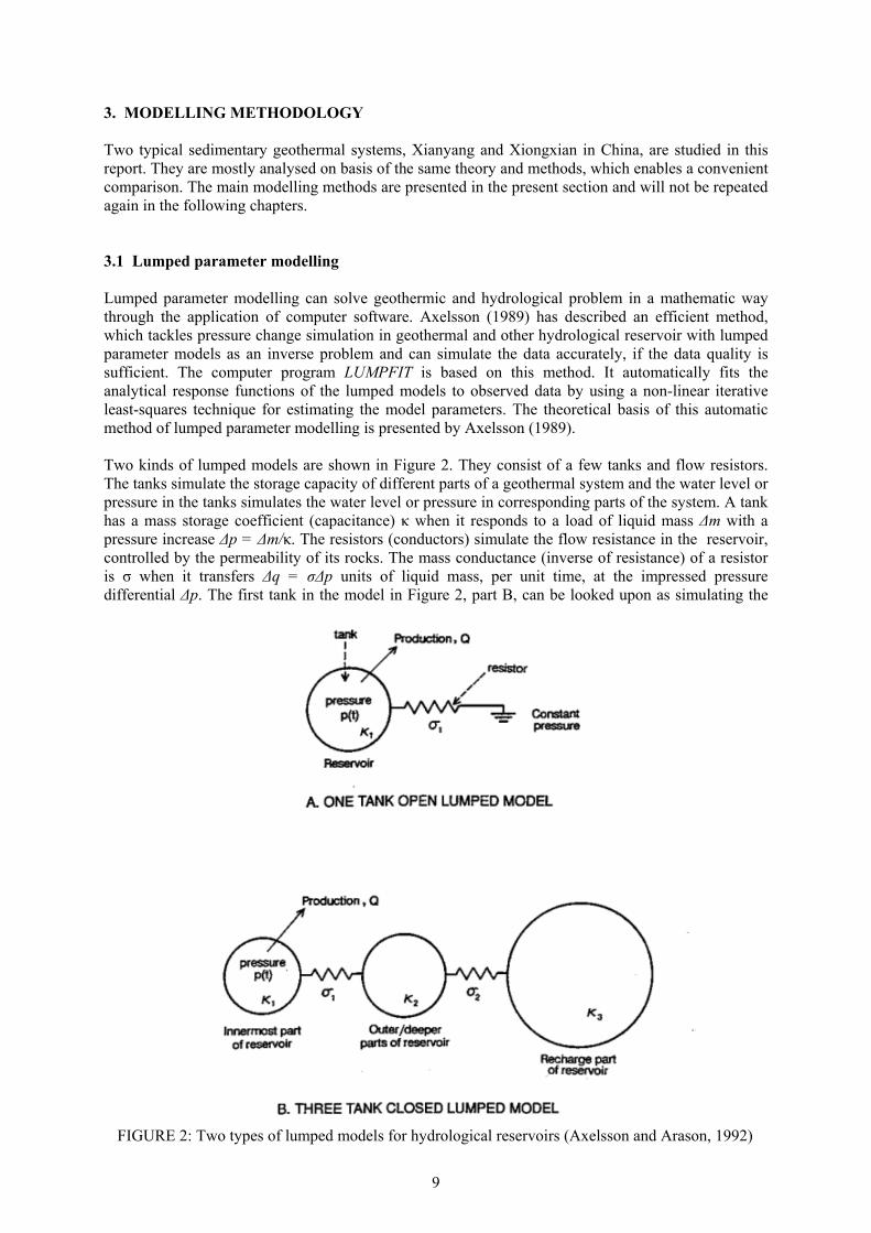
3. MODELLING METHODOLOGY Two typical sedimentary geothermal systems, Xianyang and Xiongxian in China, are studied in this report. They are mostly analysed on basis of the same theory and methods, which enables a convenient comparison. The main modelling methods are presented in the present section and will not be repeated again in the following chapters. 3.1 Lumped parameter modelling Lumped parameter modelling can solve geothermic and hydrological problem in a mathematic way through the application of computer software. Axelsson (1989) has described an efficient method, which tackles pressure change simulation in geothermal and other hydrological reservoir with lumped parameter models as an inverse problem and can simulate the data accurately, if the data quality is sufficient. The computer program LUMPFIT is based on this method. It automatically fits the analytical response functions of the lumped models to observed data by using a non-linear iterative least-squares technique for estimating the model parameters. The theoretical basis of this automatic method of lumped parameter modelling is presented by Axelsson (1989). Two kinds of lumped models are shown in Figure 2. They consist of a few tanks and flow resistors. The tanks simulate the storage capacity of different parts of a geothermal system and the water level or pressure in the tanks simulates the water level or pressure in corresponding parts of the system. A tank has a mass storage coefficient (capacitance) κ when it responds to a load of liquid mass Δm with a pressure increase Δp = Δm/κ. The resistors (conductors) simulate the flow resistance in the reservoir, controlled by the permeability of its rocks. The mass conductance (inverse of resistance) of a resistor is σ when it transfers Δq = σΔp units of liquid mass, per unit time, at the impressed pressure differential Δp. The first tank in the model in Figure 2, part B, can be looked upon as simulating the
FIGURE 2: Two types of lumped models for hydrological reservoirs (Axelsson and Arason, 1992)
10
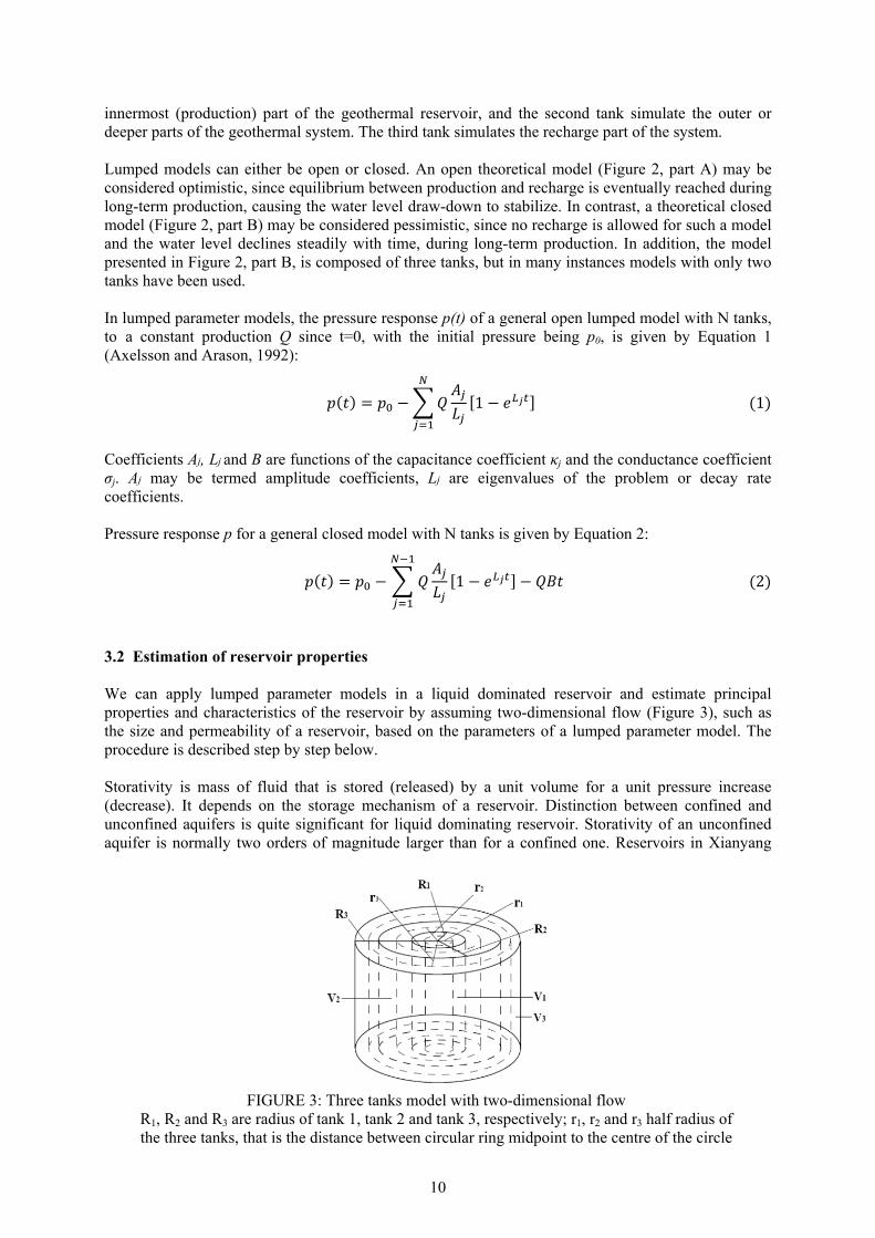
innermost (production) part of the geothermal reservoir, and the second tank simulate the outer or deeper parts of the geothermal system. The third tank simulates the recharge part of the system. Lumped models can either be open or closed. An open theoretical model (Figure 2, part A) may be considered optimistic, since equilibrium between production and recharge is eventually reached during long-term production, causing the water level draw-down to stabilize. In contrast, a theoretical closed model (Figure 2, part B) may be considered pessimistic, since no recharge is allowed for such a model and the water level declines steadily with time, during long-term production. In addition, the model presented in Figure 2, part B, is composed of three tanks, but in many instances models with only two tanks have been used. In lumped parameter models, the pressure response p(t) of a general open lumped model with N tanks, to a constant production Q since t=0, with the initial pressure being p0, is given by Equation 1 (Axelsson and Arason, 1992): ( ) = − 1 − (1) Coefficients Aj, Lj and B are functions of the capacitance coefficient κj and the conductance coefficient σj. Aj may be termed amplitude coefficients, Lj are eigenvalues of the problem or decay rate coefficients. Pressure response p for a general closed model with N tanks is given by Equation 2: ( ) = − 1 − − (2) 3.2 Estimation of reservoir properties We can apply lumped parameter models in a liquid dominated reservoir and estimate principal properties and characteristics of the reservoir by assuming two-dimensional flow (Figure 3), such as the size and permeability of a reservoir, based on the parameters of a lumped parameter model. The procedure is described step by step below. Storativity is mass of fluid that is stored (released) by a unit volume for a unit pressure increase (decrease). It depends on the storage mechanism of a reservoir. Distinction between confined and unconfined aquifers is quite significant for liquid dominating reservoir. Storativity of an unconfined aquifer is normally two orders of magnitude larger than for a confined one. Reservoirs in Xianyang
FIGURE 3: Three tanks model with two-dimensional flow
R1, R2 and R3 are radius of tank 1, tank 2 and tank 3, respectively; r1, r2 and r3 half radius of the three tanks, that is the distance between circular ring midpoint to the centre of the circle
11
and in Xiongxian that we will study in the following are both confined reservoir, however. Storativity of a confined aquifer can be expressed as: = Δ
Δ= + (1 − ) (3)
where βw = Compressibility of geothermal fluid; βr = Compressibility of rock matrix; ρw = Geothermal fluid density at specific reservoir conditions; = Porosity of a reservoir; s = Storativity of a reservoir; and V = Volume of a reservoir. After we have estimated the storativity of a reservoir, it can be used to assess to the size of the reservoir, in particular the volumes of different parts of the reservoir as well as their surface area and radius, based on the two-dimensional flow model in accordance with the following series of equations: = ; = ; = (4) where κ1, κ2 and κ3 = Capacitance or mass storage coefficients of different tanks; V1, V2 and V3 = Volume of different tanks; and s = Storativity of a reservoir. The radiuses of the parts of a reservoir in the two-dimensional model are formulized as: = = + = + + (5) where R1, R2 and R3 = radiuses of different tanks; and H = thickness of a reservoir. And then, in order to assess to the permeability of a reservoir, the concept of half radius is introduced and defined in Table 2. Then, permeability can be estimated by: = ln( )2 (6) where ki = Permeability of different reservoir parts; ri = Half radius of different tanks; σi = Conductance between tanks; and v = Viscosity of geothermal fluid. 3.3 Analysis of step-rate well test data Well-pumping test data can be used to obtain the relationship between water level in a well and flow rate and to correct for the skin loss caused by turbulent flow close to the well wall, often called production characteristics. We can use the results to categorize the potential and capacity of a well, even though they are based on the assumption of static conditions, which is not always correct. Water level in a well can be expressed by Equation 7.

12
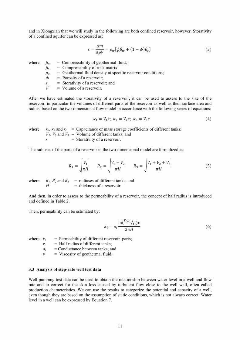
= + × + × (7) where Q = Flow rate; Ho = Water level in the well at zero flow (static well); B×Q = Linear drawdown in the reservoir; and C×Q2 = Pressure loss caused by turbulent flow at the location of inflow into the well and in the well itself. 3.4 Water level correction Geothermal fluid expands when heated and contracts when cooled. Therefore, it is necessary to correct the water level for a non-artesian geothermal well in some calculations and simulations, if temperature of well head varies significantly. This is very significant for deep wells in sedimentary systems, i.e. well WR3 in Xianyang in China. It is only utilized for space heating and does not provide hot tap water in summer, it is used for four months in the winter time every year with no pumping at all the rest of the year. The temperature at well head will decline since the cap rock above the reservoir surrounding the well cools down the geothermal fluid inside the borehole. The variation of geothermal fluid temperature with depth is approximately treated to be linear. To eliminate borehole effects, Equation 8 is used to correct water level based on the relationship of reservoir pressure balance, as sketched in Figure 4. Only the water level of well WR3 in Xianyang is corrected in the study.
TABLE 2: Half radius between lumped parameter tanks in two-dimensional flow
Model Half radius
One-tank open model = 2 = 32
Two-tanks closed model = 2 = + −2
Two-tanks open model
= 2 = + −2 = + −2
Three-tanks closed model
= 2 = + −2 = + −2
Three-tanks open model
= 2 = + −2 = + −2 = + −2
13
ℎ = − ( − ℎ )(8) where h = Corrected water level of a well outside space heating time; hc = Measured water level of a well outside space heating time; ρc = Average density of geothermal fluid column (cold) in a well outside space heating time; ρh = Average density of geothermal fluid column (hot) in a well during space heating time; d = Depth of the mid-point of the reservoir of the well (Figure 4). 3.5 Geothermal resource assessment with volumetric method Heat energy contained in a geothermal system can be estimated by different methods. Volumetric method is one of them. It, however, neglects the pressure dynamic response and geometric structure. Consequently, it does not need too much detailed information on the properties of a reservoir. It can be expressed by Equation 9. = ( , , ) ( , , ) − (9) where C(x, y, z) = Heat capacity of a geothermal reservoir; T(x, y, z) = Temperature of geothermal reservoir; To = Cut-off temperature; and dV = Volume element for integration. This equation can be simplified as shown by Equation 10 when reservoir temperature is assumed constant and reservoir thickness is approximately constant.
= ℎ ( − )(10) where A = Surface area; and h = Average effective thickness of geothermal reservoir.
FIGURE 4: Sketch demonstrating the water level correction needed for
production wells outside the space heating time
14
The average volumetric heat capacity C can be obtained by Equation 11 assuming a geothermal system to be homogenous. = (1 − ) + (11) where ϕ = Porosity of geothermal reservoir; ρr and ρw = Density of rock and geothermal fluid in geothermal reservoir, respectively; and Cr and Cw = Specific heat of rock and geothermal fluid in geothermal reservoir, (J/(kg·°C)). The recovery factor R is an estimate of how easily the heat contained in a geothermal system can be extracted. The recoverable heat QR from a geothermal system, estimated by incorporating the recovery factor, is given by Equation 12. = (12)
15
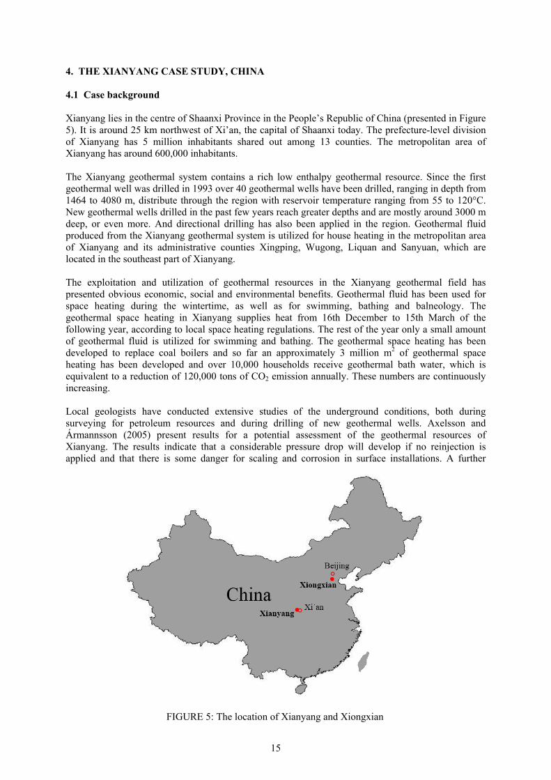
4. THE XIANYANG CASE STUDY, CHINA 4.1 Case background Xianyang lies in the centre of Shaanxi Province in the People’s Republic of China (presented in Figure 5). It is around 25 km northwest of Xi’an, the capital of Shaanxi today. The prefecture-level division of Xianyang has 5 million inhabitants shared out among 13 counties. The metropolitan area of Xianyang has around 600,000 inhabitants. The Xianyang geothermal system contains a rich low enthalpy geothermal resource. Since the first geothermal well was drilled in 1993 over 40 geothermal wells have been drilled, ranging in depth from 1464 to 4080 m, distribute through the region with reservoir temperature ranging from 55 to 120°C. New geothermal wells drilled in the past few years reach greater depths and are mostly around 3000 m deep, or even more. And directional drilling has also been applied in the region. Geothermal fluid produced from the Xianyang geothermal system is utilized for house heating in the metropolitan area of Xianyang and its administrative counties Xingping, Wugong, Liquan and Sanyuan, which are located in the southeast part of Xianyang. The exploitation and utilization of geothermal resources in the Xianyang geothermal field has presented obvious economic, social and environmental benefits. Geothermal fluid has been used for space heating during the wintertime, as well as for swimming, bathing and balneology. The geothermal space heating in Xianyang supplies heat from 16th December to 15th March of the following year, according to local space heating regulations. The rest of the year only a small amount of geothermal fluid is utilized for swimming and bathing. The geothermal space heating has been developed to replace coal boilers and so far an approximately 3 million m2 of geothermal space heating has been developed and over 10,000 households receive geothermal bath water, which is equivalent to a reduction of 120,000 tons of CO2 emission annually. These numbers are continuously increasing. Local geologists have conducted extensive studies of the underground conditions, both during surveying for petroleum resources and during drilling of new geothermal wells. Axelsson and Ármannsson (2005) present results for a potential assessment of the geothermal resources of Xianyang. The results indicate that a considerable pressure drop will develop if no reinjection is applied and that there is some danger for scaling and corrosion in surface installations. A further
FIGURE 5: The location of Xianyang and Xiongxian
16
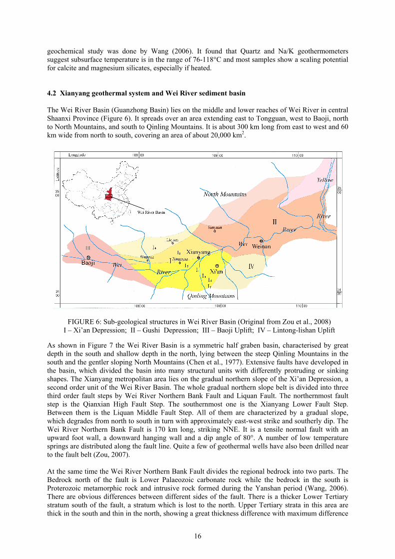
geochemical study was done by Wang (2006). It found that Quartz and Na/K geothermometers suggest subsurface temperature is in the range of 76-118°C and most samples show a scaling potential for calcite and magnesium silicates, especially if heated. 4.2 Xianyang geothermal system and Wei River sediment basin The Wei River Basin (Guanzhong Basin) lies on the middle and lower reaches of Wei River in central Shaanxi Province (Figure 6). It spreads over an area extending east to Tongguan, west to Baoji, north to North Mountains, and south to Qinling Mountains. It is about 300 km long from east to west and 60 km wide from north to south, covering an area of about 20,000 km2.
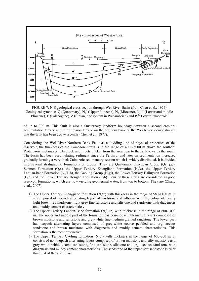
As shown in Figure 7 the Wei River Basin is a symmetric half graben basin, characterised by great depth in the south and shallow depth in the north, lying between the steep Qinling Mountains in the south and the gentler sloping North Mountains (Chen et al., 1977). Extensive faults have developed in the basin, which divided the basin into many structural units with differently protruding or sinking shapes. The Xianyang metropolitan area lies on the gradual northern slope of the Xi’an Depression, a second order unit of the Wei River Basin. The whole gradual northern slope belt is divided into three third order fault steps by Wei River Northern Bank Fault and Liquan Fault. The northernmost fault step is the Qianxian High Fault Step. The southernmost one is the Xianyang Lower Fault Step. Between them is the Liquan Middle Fault Step. All of them are characterized by a gradual slope, which degrades from north to south in turn with approximately east-west strike and southerly dip. The Wei River Northern Bank Fault is 170 km long, striking NNE. It is a tensile normal fault with an upward foot wall, a downward hanging wall and a dip angle of 80°. A number of low temperature springs are distributed along the fault line. Quite a few of geothermal wells have also been drilled near to the fault belt (Zou, 2007). At the same time the Wei River Northern Bank Fault divides the regional bedrock into two parts. The Bedrock north of the fault is Lower Palaeozoic carbonate rock while the bedrock in the south is Proterozoic metamorphic rock and intrusive rock formed during the Yanshan period (Wang, 2006). There are obvious differences between different sides of the fault. There is a thicker Lower Tertiary stratum south of the fault, a stratum which is lost to the north. Upper Tertiary strata in this area are thick in the south and thin in the north, showing a great thickness difference with maximum difference
FIGURE 6: Sub-geological structures in Wei River Basin (Original from Zou et al., 2008) I – Xi’an Depression; II – Gushi Depression; III – Baoji Uplift; IV – Lintong-lishan Uplift
17
of up to 700 m. This fault is also a Quaternary landform boundary between a second erosion-accumulation terrace and third erosion terrace on the northern bank of the Wei River, demonstrating that the fault has been active recently (Chen et al., 1977). Considering the Wei River Northern Bank Fault as a dividing line of physical properties of the reservoir, the thickness of the Cainozoic strata is in the range of 4000-5000 m above the southern Proterozoic metamorphic bedrock and it gets thicker from the area near to the fault towards the south. The basin has been accumulating sediment since the Tertiary, and later on sedimentation increased gradually forming a very thick Cainozoic sedimentary section which is widely distributed. It is divided into several stratigraphic formations or groups. They are Quaternary Qinchuan Group (Q2 - 4qc), Sanmen Formation (Q1s), the Upper Tertiary Zhangjiapo Formation (N2
2z), the Upper Tertiary Lantian-bahe Formation (N2
1l+b), the Gaoling Group (N1gl), the Lower Tertiary Bailuyuan Formation (E3b) and the Lower Tertiary Honghe Formation (E2h). Four of these strata are considered as good reservoir formations, which are now yielding geothermal water, from top to bottom. They are (Zhang et al., 2007):
1) The Upper Tertiary Zhangjiapo formation (N22z) with thickness in the range of 580-1100 m. It
is composed of isopach alternating layers of mudstone and siltstone with the colour of mostly light brown-red mudstone, light grey fine sandstone and siltstone and sandstone with diagenesis and muddy cement characteristics.
2) The Upper Tertiary Lantian-Bahe formation (N21l+b) with thickness in the range of 600-1000
m. The upper and middle part of the formation has non-isopach alternating layers composed of brown mudstone and sandstone and grey-white fine-medium grained sandstone. The lower part has isopach alternating layers composed of grey-white coarse pebbled and argillaceous sandstone and brown mudstone with diagenesis and muddy cement characteristics. This formation is the most productive.
3) The Upper Tertiary Gaoling formation (N1gl) with thickness in the range of 600-800 m. It consists of non-isopach alternating layers composed of brown mudstone and silty mudstone and grey-white pebble coarse sandstone, fine sandstone, siltstone and argillaceous sandstone with diagenesis and muddy cement characteristics. The sandstone of the upper part sandstone is finer than that of the lower part.
FIGURE 7: N-S geological cross-section through Wei River Basin (from Chen et al., 1977) Geological symbols: Q (Quaternary), N2
3 (Upper Pliocene), N1 (Miocene), N21-2 (Lower and middle
Pliocene), E (Palaeogene), Z (Sinian, one system in Precambrian) and Pz1: Lower Palaeozoic
18
4) The Lower Tertiary Bailuyuan formation (E3b), found below the above formations, also consist of alternating layer of sandstone and mudstone. But it only distributes in southeast part of Xianyang and northwest part of Xi’an. It has even higher temperatures and has been reached by a limited numbers of wells in Xi’an. The thickness of the formation is between 500 and 600 m. The upper part of the formation has non-isopach alternating layers of dark brown and grey-yellow mudstone, silty mudstone and light grey and grey-white siltstone, fine sandstone and medium-grained sandstone. The lower part is composed of brown mudstone and silty mudstone and grey-white pebble coarse sandstone.
In the north of the Wei River Northern Bank Fault the depth of the bedrock (consisting of Lower Paleozoic carbonate rock) varies gradually from 3000 m near the southern boundary near the fault to 2000 m in Liquan County in the north part of the basin. This is due to the Xianli Uplift, which has a slope with dip toward south. It has lost the Lower Tertiary rocks and just includes Upper Tertiary and Quaternary rock in the north of the fault. The thickness of the sediment reduces and the lithology gets gradually coarser from south to north. Thickness of the same stratum south of the fault is 200-300 m thicker than in the north (Chen et al., 1977). The Wei River Northern Bank Fault is believed to be the most important structure for hydrogeology. The fault and limestone beneath the Tertiary stratum and in the north of the fault are believed to provide weak recharge for the main geothermal reservoir layers. In addition, the geothermal field is divided into two parts by the Wei River Northern Bank Fault due to the different reservoir properties of both sides.
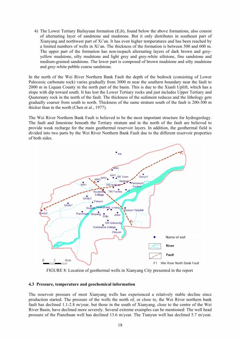
4.3 Pressure, temperature and geochemical information The reservoir pressure of most Xianyang wells has experienced a relatively stable decline since production started. The pressure of the wells the north of, or close to, the Wei River northern bank fault has declined 1.1-2.8 m/year, but those in the south of Xianyang, close to the centre of the Wei River Basin, have declined more severely. Several extreme examples can be mentioned: The well head pressure of the Pianzhuan well has declined 13.6 m/year. The Tianyun well has declined 5.7 m/year.
FIGURE 8: Location of geothermal wells in Xianyang City presented in the report
19
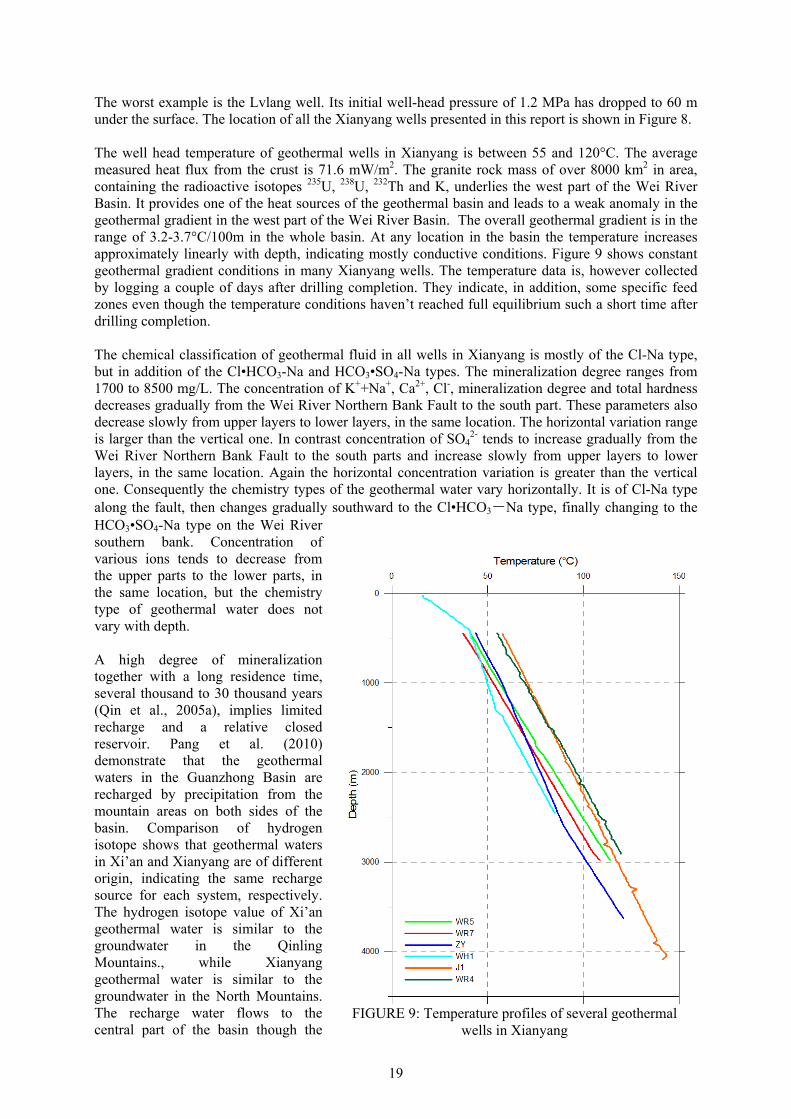
The worst example is the Lvlang well. Its initial well-head pressure of 1.2 MPa has dropped to 60 m under the surface. The location of all the Xianyang wells presented in this report is shown in Figure 8. The well head temperature of geothermal wells in Xianyang is between 55 and 120°C. The average measured heat flux from the crust is 71.6 mW/m2. The granite rock mass of over 8000 km2 in area, containing the radioactive isotopes 235U, 238U, 232Th and K, underlies the west part of the Wei River Basin. It provides one of the heat sources of the geothermal basin and leads to a weak anomaly in the geothermal gradient in the west part of the Wei River Basin. The overall geothermal gradient is in the range of 3.2-3.7°C/100m in the whole basin. At any location in the basin the temperature increases approximately linearly with depth, indicating mostly conductive conditions. Figure 9 shows constant geothermal gradient conditions in many Xianyang wells. The temperature data is, however collected by logging a couple of days after drilling completion. They indicate, in addition, some specific feed zones even though the temperature conditions haven’t reached full equilibrium such a short time after drilling completion. The chemical classification of geothermal fluid in all wells in Xianyang is mostly of the Cl-Na type, but in addition of the Cl•HCO3-Na and HCO3•SO4-Na types. The mineralization degree ranges from 1700 to 8500 mg/L. The concentration of K++Na+, Ca2+, Cl-, mineralization degree and total hardness decreases gradually from the Wei River Northern Bank Fault to the south part. These parameters also decrease slowly from upper layers to lower layers, in the same location. The horizontal variation range is larger than the vertical one. In contrast concentration of SO4
2- tends to increase gradually from the Wei River Northern Bank Fault to the south parts and increase slowly from upper layers to lower layers, in the same location. Again the horizontal concentration variation is greater than the vertical one. Consequently the chemistry types of the geothermal water vary horizontally. It is of Cl-Na type along the fault, then changes gradually southward to the Cl•HCO3-Na type, finally changing to the HCO3•SO4-Na type on the Wei River southern bank. Concentration of various ions tends to decrease from the upper parts to the lower parts, in the same location, but the chemistry type of geothermal water does not vary with depth. A high degree of mineralization together with a long residence time, several thousand to 30 thousand years (Qin et al., 2005a), implies limited recharge and a relative closed reservoir. Pang et al. (2010) demonstrate that the geothermal waters in the Guanzhong Basin are recharged by precipitation from the mountain areas on both sides of the basin. Comparison of hydrogen isotope shows that geothermal waters in Xi’an and Xianyang are of different origin, indicating the same recharge source for each system, respectively. The hydrogen isotope value of Xi’an geothermal water is similar to the groundwater in the Qinling Mountains., while Xianyang geothermal water is similar to the groundwater in the North Mountains. The recharge water flows to the central part of the basin though the
FIGURE 9: Temperature profiles of several geothermal
wells in Xianyang
20
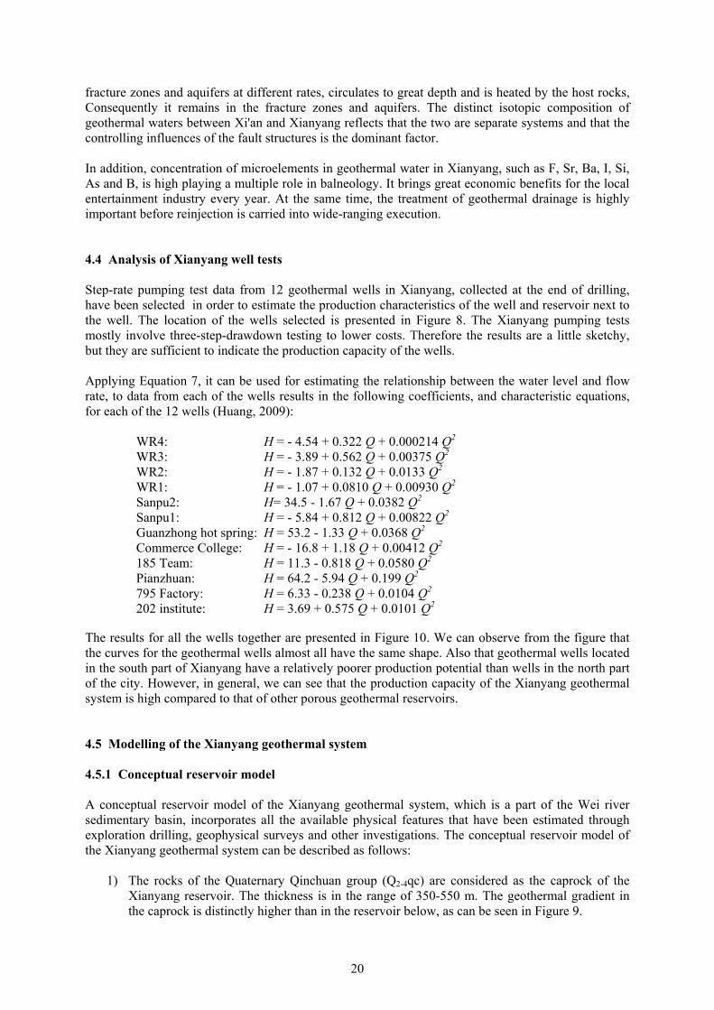
fracture zones and aquifers at different rates, circulates to great depth and is heated by the host rocks, Consequently it remains in the fracture zones and aquifers. The distinct isotopic composition of geothermal waters between Xi'an and Xianyang reflects that the two are separate systems and that the controlling influences of the fault structures is the dominant factor. In addition, concentration of microelements in geothermal water in Xianyang, such as F, Sr, Ba, I, Si, As and B, is high playing a multiple role in balneology. It brings great economic benefits for the local entertainment industry every year. At the same time, the treatment of geothermal drainage is highly important before reinjection is carried into wide-ranging execution. 4.4 Analysis of Xianyang well tests Step-rate pumping test data from 12 geothermal wells in Xianyang, collected at the end of drilling, have been selected in order to estimate the production characteristics of the well and reservoir next to the well. The location of the wells selected is presented in Figure 8. The Xianyang pumping tests mostly involve three-step-drawdown testing to lower costs. Therefore the results are a little sketchy, but they are sufficient to indicate the production capacity of the wells. Applying Equation 7, it can be used for estimating the relationship between the water level and flow rate, to data from each of the wells results in the following coefficients, and characteristic equations, for each of the 12 wells (Huang, 2009):
WR4: H = - 4.54 + 0.322 Q + 0.000214 Q2 WR3: H = - 3.89 + 0.562 Q + 0.00375 Q2 WR2: H = - 1.87 + 0.132 Q + 0.0133 Q2 WR1: H = - 1.07 + 0.0810 Q + 0.00930 Q2 Sanpu2: H= 34.5 - 1.67 Q + 0.0382 Q2 Sanpu1: H = - 5.84 + 0.812 Q + 0.00822 Q2 Guanzhong hot spring: H = 53.2 - 1.33 Q + 0.0368 Q2 Commerce College: H = - 16.8 + 1.18 Q + 0.00412 Q2 185 Team: H = 11.3 - 0.818 Q + 0.0580 Q2 Pianzhuan: H = 64.2 - 5.94 Q + 0.199 Q2 795 Factory: H = 6.33 - 0.238 Q + 0.0104 Q2 202 institute: H = 3.69 + 0.575 Q + 0.0101 Q2
The results for all the wells together are presented in Figure 10. We can observe from the figure that the curves for the geothermal wells almost all have the same shape. Also that geothermal wells located in the south part of Xianyang have a relatively poorer production potential than wells in the north part of the city. However, in general, we can see that the production capacity of the Xianyang geothermal system is high compared to that of other porous geothermal reservoirs. 4.5 Modelling of the Xianyang geothermal system 4.5.1 Conceptual reservoir model A conceptual reservoir model of the Xianyang geothermal system, which is a part of the Wei river sedimentary basin, incorporates all the available physical features that have been estimated through exploration drilling, geophysical surveys and other investigations. The conceptual reservoir model of the Xianyang geothermal system can be described as follows:
1) The rocks of the Quaternary Qinchuan group (Q2-4qc) are considered as the caprock of the Xianyang reservoir. The thickness is in the range of 350-550 m. The geothermal gradient in the caprock is distinctly higher than in the reservoir below, as can be seen in Figure 9.
21
2) The Upper Tertiary Zhangjiapo Formation (N2
2z), Upper Tertiary Lantian-bahe Formation (N2
1l+b) and Upper Tertiary Gaoling Group (N1gl) are considered as the reservoir of the Xianyang geothermal system. These are composed of alternating sandstone and mudstone layers and the total thickness is in the range of 1780-3000m. The detail of the formations is presented in Section 4.2 above. The sandstones and mudstones in these formations are aquifers and aquicludes, respectively. Those alternating sandstone and mudstone layers are treated as a uniform reservoir in the following model simulation.
3) The Wei River Northern Bank Fault, Chang’an-Lintong Fault and Qinling Mountain Front Fault as well as the limestone which is beneath the Tertiary stratum and in the north of Wei River Northern Bank Fault are believed to contribute a weak recharge for the main production layer. The details are presented in Section 4.2 above. The large-scale permeability structure of the Xianyang reservoir is, furthermore, partly controlled by these faults.
4) The Xianyang geothermal reservoir is a typical low temperature liquid-dominated sedimentary reservoir of the porous type. The average measured heat flux from the crust is 71.6 mW/m2. And the geothermal gradient is 3.2-3.7°C/100m.
Xianyang city is located in the centre of the Wei River sediment basin and we just study the reservoir in the metropolitan area of Xianyang administrative territory, so called Xianyang reservoir, but not the whole Wei River Basin. It is a typical confined liquid-dominated reservoir and is a part of the Wei River Basin. A significant feature of the system is the alternation of beds of sandstone and mudstone that widely exists in the Xianyang geothermal system. It is considered a single, uniform reservoir for the purpose of the study presented in this report. The Wei River sediment basin is regarded as a reservoir with very weak recharge by most geologists in the region, so it will be simulated as both a
FIGURE 10: Approximate production characteristics of several Xianyang geothermal wells
based on step-rate well test data collected at end of drilling
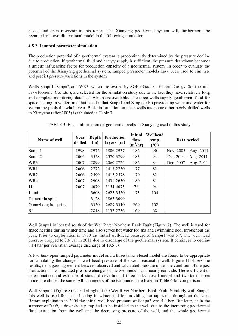
22
closed and open reservoir in this report. The Xianyang geothermal system will, furthermore, be regarded as a two-dimensional model in the following simulation. 4.5.2 Lumped parameter simulation The production potential of a geothermal system is predominantly determined by the pressure decline due to production. If geothermal fluid and energy supply is sufficient, the pressure drawdown becomes a unique influencing factor for production capacity of a geothermal system. In order to evaluate the potential of the Xianyang geothermal system, lumped parameter models have been used to simulate and predict pressure variations in the system. Wells Sanpu1, Sanpu2 and WR3, which are owned by SGE (Shaanxi Green Energy Geothermal Development Co. Ltd.), are selected for the simulation study due to the fact they have relatively long and complete monitoring data-sets, which are available. The three wells supply geothermal fluid for space heating in winter time, but besides that Sanpu1 and Sanpu2 also provide tap water and water for swimming pools the whole year. Basic information on these wells and some other newly-drilled wells in Xianyang (after 2005) is tabulated in Table 3.
Well Sanpu1 is located south of the Wei River Northern Bank Fault (Figure 8). The well is used for space heating during winter time and also serves hot water for spa and swimming pool throughout the year. Prior to exploitation in 1998 the initial well-head pressure of Sanpu1 was 5.7. The well head pressure dropped to 3.9 bar in 2011 due to discharge of the geothermal system. It continues to decline 0.14 bar per year at an average discharge of 10.5 l/s. A two-tank open lumped parameter model and a three-tanks closed model are found to be appropriate for simulating the change in well head pressure of the well reasonably well. Figure 11 shows the results, i.e. a good agreement between observed and calculated pressure under the condition of the past production. The simulated pressure changes of the two models also nearly coincide. The coefficient of determination and estimate of standard deviation of three-tanks closed model and two-tanks open model are almost the same. All parameters of the two models are listed in Table 4 for comparison. Well Sanpu 2 (Figure 8) is drilled right at the Wei River Northern Bank Fault. Similarly with Sanpu1 this well is used for space heating in winter and for providing hot tap water throughout the year. Before exploitation in 2004 the initial well-head pressure of Sanpu2 was 5.0 bar. But later, or in the summer of 2009, a down-hole pump had to be installed in the well due to the increasing geothermal fluid extraction from the well and the decreasing pressure of the well, and the whole geothermal
TABLE 3: Basic information on geothermal wells in Xianyang used in this study
Name of well Year
drilled Depth
(m) Production layers (m)
Initial flow
(m3/hr)
Wellhead
temp. (°C)
Data period
Sanpu1 1998 2975 1806-2937 182 90 Nov. 2005 – Aug. 2011Sanpu2 2004 3558 2570-3299 183 94 Oct. 2004 – Aug. 2011 WR3 2007 2899 2060-2724 182 84 Dec. 2007 – Aug. 2011
WR1 2006 2772 1413-2750 177 82 WR2 2006 2599 1415-2578 170 82 WR4 2007 2908 1431-2630 180 81 J1 2007 4079 3154-4073 76 94 Jintai 3608 2625-3550 173 104 Tumour hospital 3128 1867-3099 Guanzhong hotspring 3350 2689-3310 269 102 R4 2818 1137-2736 169 68
23
system. Well head pressure of well Sanpu 2 had dropped to -0.2 bar in 2011. It drops about 0.74 bar per year at an average discharge of 9.7 l/s. A two-tank open model and a three-tank closed model are found to be the best fitting simulation models for well Sanpu 2. The result of the simulation is shown in Figure 12. The two-tank open model for well Sanpu 2 has a coefficient of determination of 91.4% and a standard deviation of 0.574 bar, assuming the initial pressure to be 5.7 bar and the turbulence coefficient (C in Equation 7) to be 0, which is slightly different from the actual conditions (5.0 bar and 0.0382 bar/(l/s)2, respectively). The rest of the parameters of the two models are listed in Table 5. The three-tank closed model yields a coefficient of determination of 92.2% and a standard deviation of 0.552 bar. This is just a slight improvement over the two-tank open model. Therefore, the two models are both applied for well Sanpu 2. Well WR3 is located north of the Wei River North Bank Fault (Figure 8). Geothermal fluid is only extracted from the well in winter and the well is not discharged in the summer at all. This well has
FIGURE 11: Comparison of observed pressure for well Sanpu1 and pressure simulated
by a lumped parameter models
TABLE 4: Parameters of the lumped parameter models for well Sanpu1
Parameter Two-tank open model Three-tank closed model К1 (ms2) 22 16 К2 (ms2) 1120 870 К3 (ms2) 450 σ1 (ms) 0.000024 0.000025 σ2 (ms) 0.0000012 0.000012 Initial pressure (bar) 5.0 5.0 The past average production (l/s) 8.8 8.8 Root mean square misfit 0.76 0.76 Estimate of standard deviation 0.78 0.79 Coefficient of determination 91.7% 91.7%
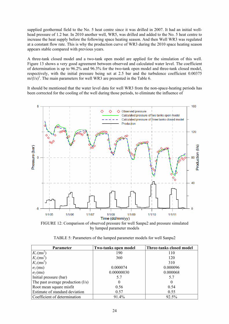
24
supplied geothermal field to the No. 5 heat centre since it was drilled in 2007. It had an initial well-head pressure of 1.2 bar. In 2010 another well, WR5, was drilled and added to the No. 5 heat centre to increase the heat supply before the following space heating season. And then Well WR3 was regulated at a constant flow rate. This is why the production curve of WR3 during the 2010 space heating season appears stable compared with previous years. A three-tank closed model and a two-tank open model are applied for the simulation of this well. Figure 13 shows a very good agreement between observed and calculated water level. The coefficient of determination is up to 96.2% and 96.3% for the two-tank open model and three-tank closed model, respectively, with the initial pressure being set at 2.5 bar and the turbulence coefficient 0.00375 m/(l/s)2. The main parameters for well WR3 are presented in the Table 6. It should be mentioned that the water level data for well WR3 from the non-space-heating periods has been corrected for the cooling of the well during those periods, to eliminate the influence of
FIGURE 12: Comparison of observed pressure for well Sanpu2 and pressure simulated
by lumped parameter models
TABLE 5: Parameters of the lumped parameter models for well Sanpu2
Parameter Two-tanks open model Three-tanks closed model К1 (ms2) 190 110 К2 (ms2) 360 120 К3 (ms2) 310 σ1 (ms) 0.000074 0.000096 σ2 (ms) 0.00000030 0.000068 Initial pressure (bar) 5.7 5.7 The past average production (l/s) 0 0 Root mean square misfit 0.56 0.54 Estimate of standard deviation 0.57 0.55 Coefficient of determination 91.4% 92.5%
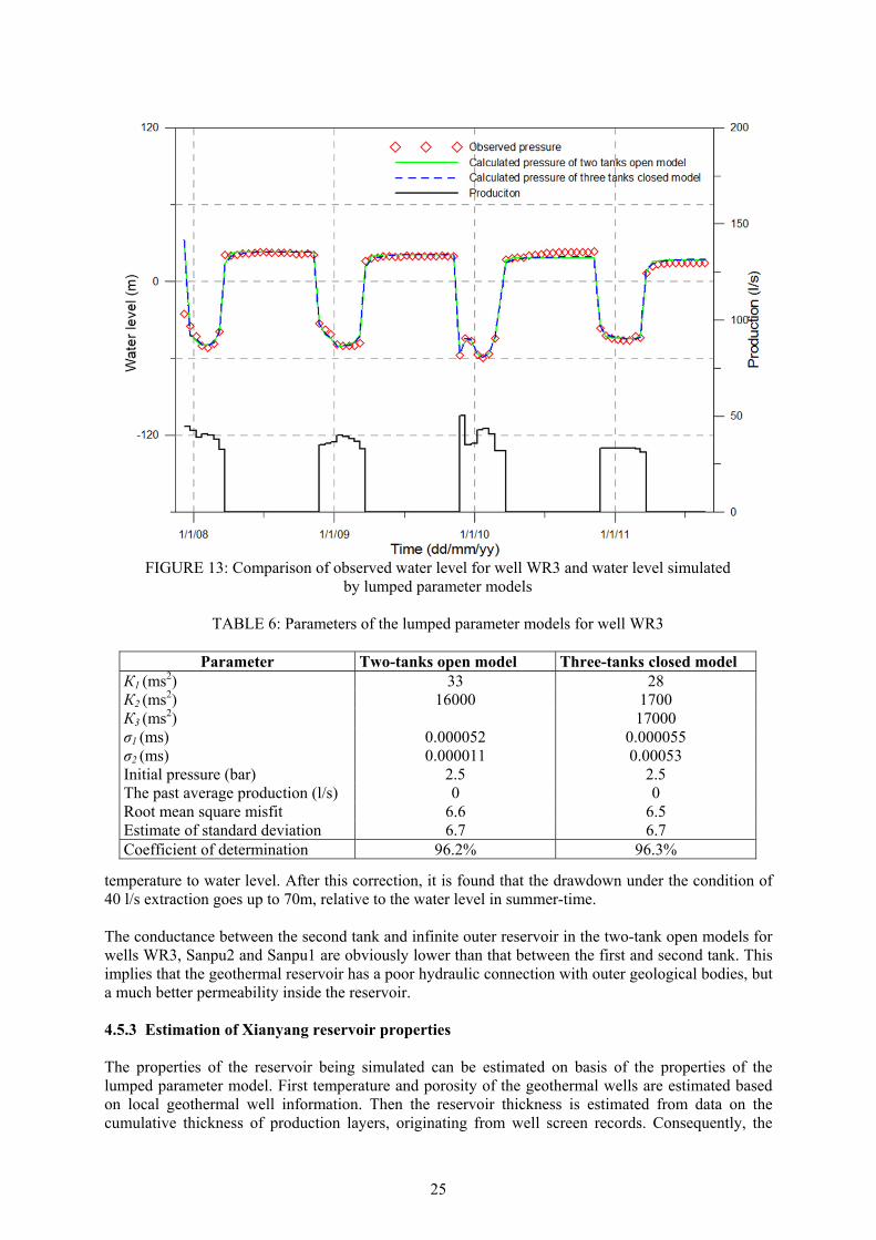
25
temperature to water level. After this correction, it is found that the drawdown under the condition of 40 l/s extraction goes up to 70m, relative to the water level in summer-time. The conductance between the second tank and infinite outer reservoir in the two-tank open models for wells WR3, Sanpu2 and Sanpu1 are obviously lower than that between the first and second tank. This implies that the geothermal reservoir has a poor hydraulic connection with outer geological bodies, but a much better permeability inside the reservoir. 4.5.3 Estimation of Xianyang reservoir properties The properties of the reservoir being simulated can be estimated on basis of the properties of the lumped parameter model. First temperature and porosity of the geothermal wells are estimated based on local geothermal well information. Then the reservoir thickness is estimated from data on the cumulative thickness of production layers, originating from well screen records. Consequently, the
FIGURE 13: Comparison of observed water level for well WR3 and water level simulated
by lumped parameter models
TABLE 6: Parameters of the lumped parameter models for well WR3
Parameter Two-tanks open model Three-tanks closed model К1 (ms2) 33 28 К2 (ms2) 16000 1700 К3 (ms2) 17000 σ1 (ms) 0.000052 0.000055 σ2 (ms) 0.000011 0.00053 Initial pressure (bar) 2.5 2.5 The past average production (l/s) 0 0 Root mean square misfit 6.6 6.5 Estimate of standard deviation 6.7 6.7 Coefficient of determination 96.2% 96.3%
26
storativity of the reservoir can be estimated by Equation 3. The resulting values, and result of the storativity calculation, for the three wells, Sanpu1, Sanpu2 and WR3, are presented in Table 7.
TABLE 7: Physical properties of the Xianyang reservoir
Parameters Sanpu1 Sanpu2 WR3 Comressipbility of water (Pa-1) 5.0·10-10 5.0·10-10 5.0·10-10 Compressibility of rock (Pa-1) 2.0·10-11 2.0·10-11 2.0·10-11 Density of water (kg/m3) 975 971 975 Porosity of reservoir 0.14 0.17 0.14 Thickness of reservoir (m) 1130 1370 895 Kinematic viscosity of water (m2/s) 3.2·10-7 3.0·10-7 3.3·10-7 Storativity of reservoir (kg/m3Pa) 8.4·10-8 9.8·10-8 8.4·10-8
Consequently, the size of a model, such as volume, surface area and radius of reservoir, can be derived for both the two-tank open model and three-tank closed model by using Equations 4, 5 and 6. The estimated model size and permeability for Sanpu1, Sanpu2 and WR3 are consequently shown in Table 8. The first tank, second tank and third tank represent different parts of the reservoir that can be influenced by a single well.
TABLE 8: Reservoir properties of the Xianyang reservoir based on properties of lumped parameter models for wells Sanpu 1, Sanpu 2 and WR3 and the parameters in Table 7
Size Tank Sanpu1 Sanpu2 WR3
2-O 3-C 2-O 3-C 2-O 3-C
Volume (km3)
First tank 0.26 0.19 1.9 1.1 0.40 0.33
Second tank 14 10 37 12 190 20
Third tank 5.44 32.0 198
Total 14 16 39 46 190 220
Area (km2)
First tank 0.23 0.17 1.4 0.82 0.45 0.37
Second tank 12 9.2 27 9.0 210 23
Third tank 4.8 23 220
Total 12 14 28 33 210 240
Radius (km)
First tank 0.27 0.23 0.66 0.51 0.38 0.34
Second tank 2.0 1.7 3.0 1.8 8.3 2.7
Third tank 2.1 3.3 8.8
Permeability (mD)
Inner 2.3 2.4 4.4 5.0 9.5 7.0 Outer 0.049 0.35 0.0090 1.9 0.65 41
Permeability-thickness (D-m)
Inner 2.6 2.7 6.1 6.9 8.5 6.3 Outer 0.056 0.40 0.012 2.5 0.58 37
It should be pointed that permeability gotten from the simulation result is average permeability of sandstone and mudstone because the lumped model assumes that the alternating layers of sandstone and mudstone is one reservoir. In addition the estimated permeability is likely to be lower than the actual permeability of the Xianyang reservoir because of the assumption that the pressure change of each of the wells simulated is just induced by the production of the well itself, but not affected by other wells nearby. The estimated permeability for the three wells indicates that it decreases southwards. This is approximately in accordance with the pumping test result shown in Figure 10. Actually, based on geological survey and drilling result, the grain size of the sedimentary rock in the Xianyang geothermal system decreases in size as one moves southward, there is especially a remarkable change
27
from one side of the Wei River Northern Bank Fault to the other. This is in agreement with the estimated permeability as well. The radius of the model tanks implies the radius of hydraulic influence of each of the wells, which should also be considered when designing the interval between wells. The estimated permeability between the second tank and third tanks of the Sanpu1 and Sanpu2 wells shows that the hydraulic connection of the reservoir around the wells to the outer parts of the geothermal system is not so good. On the contrary, the connection of well WR3 is much better, probably because of recharge from the limestone beneath the sandstone reservoir. 4.5.4 Pressure predictions Once the model parameters for a reservoir, or particular well, have been obtained, it is possible to predict water level changes for given future production schemes. In order to reassess the production potential of the Xianyang reservoir, the lumped parameter models were used to predict the future water level change during long term production. For the purpose of calculating the predictions a future production period of 15 years was appended to the input file. The process can be summed up as follows: Firstly, the best fitting lumped parameter model, which can best represent the actual situation of a reservoir, is selected as prediction model following the simulation. Then, different production scenarios are set up and corresponding input files set up. Three scenarios (Table 9) have been set up for this work. The first one assumes maintaining the average production of the past few years, without any changes. It predicts what will happen in the future if the present production is continued. The second one assumes increasing the production by 25%. This is just what space heating companies in Xianyang have planned because of foreseen growth of the space-heating market. The third one assumes maintaining the present extraction but with 15% reinjection (equivalent to 85% net production). Such limited reinjection is assumed because sandstone reinjection is difficult, as has been confirmed by reinjection testing of doublets being carried out in Xianyang. Therefore 15% seems appropriate for the future development. It has approximately the same effect as decreasing production by 15%. Both an open model and a closed model were used for the predictions for the Xianyang reservoir response. The results for closed and open models represent two extreme conditions for lumped parameter modelling, and geothermal system, or pessimistic and optimistic scenarios. In addition there is not a significant distinction between parameters of the two types of models as discussed in Section 4.5.2. The real behaviour of a geothermal system would be somewhere between these two simulated responses. The difference between the predictions of open and closed models is noteworthy and also reflects the nature of the Xianyang system.
It will make prediction inaccurate since past average production of model of Sanpu1 is not 0 due to methodology of lumped parameter model itself. We just predict pressure response of future by the models of Sanpu2 and WR3 (Figures 14-19) in this section. The two-tank open model and the three-tank closed model are shown to be the most proper lumped parameter models for Well Sanpu2. This well has a production of 9.7 l/s in the past seven years on average. The predictions for the second scenario are calculated assuming that the flow rate will be continued. As shown as Figure 15, the open model gives a little more pessimistic forecast than the closed model. Normally an open model gives a more optimistic forecast than a closed one. This is not common in such predictions. The reason is that the conductor between the second tank and infinite outer reservoir in the two-tanks open model is just 2.99·10-7 ms, two orders of magnitude lower than
TABLE 9: Scenarios used to predict pressure changes in the Xianyang geothermal reservoir
Scenarios Net production(l/s)
Sanpu2 WR3 Scenario 1 15% injection 8.2 10.6 Scenario 2 Keep present production 9.7 12.5 Scenario 3 Increase 25% production 12.1 15.6
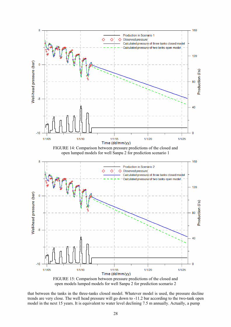
28
that between the tanks in the three-tanks closed model. Whatever model is used, the pressure decline trends are very close. The well head pressure will go down to -11.2 bar according to the two-tank open model in the next 15 years. It is equivalent to water level declining 7.5 m annually. Actually, a pump
FIGURE 14: Comparison between pressure predictions of the closed and open lumped models for well Sanpu 2 for prediction scenario 1
FIGURE 15: Comparison between pressure predictions of the closed and open models lumped models for well Sanpu 2 for prediction scenario 2
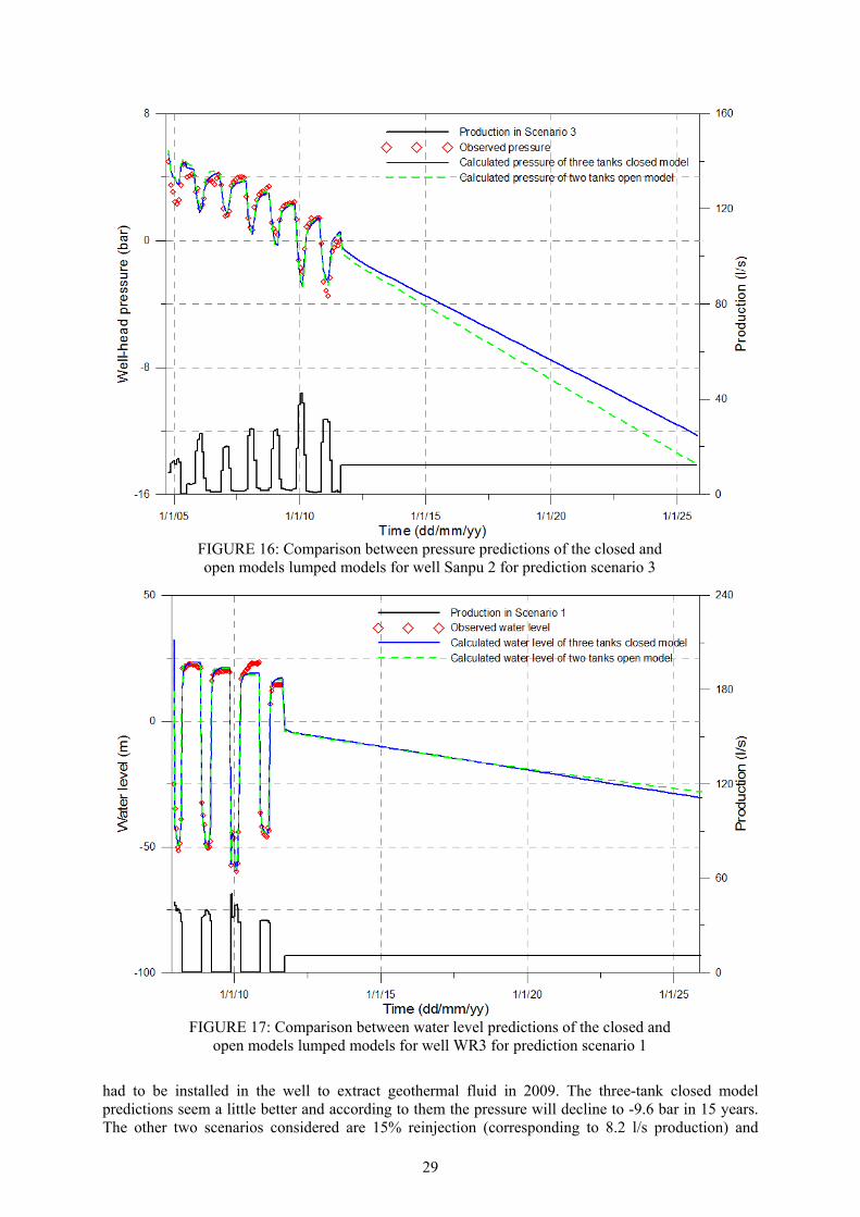
29
had to be installed in the well to extract geothermal fluid in 2009. The three-tank closed model predictions seem a little better and according to them the pressure will decline to -9.6 bar in 15 years. The other two scenarios considered are 15% reinjection (corresponding to 8.2 l/s production) and
FIGURE 16: Comparison between pressure predictions of the closed and open models lumped models for well Sanpu 2 for prediction scenario 3
FIGURE 17: Comparison between water level predictions of the closed and open models lumped models for well WR3 for prediction scenario 1
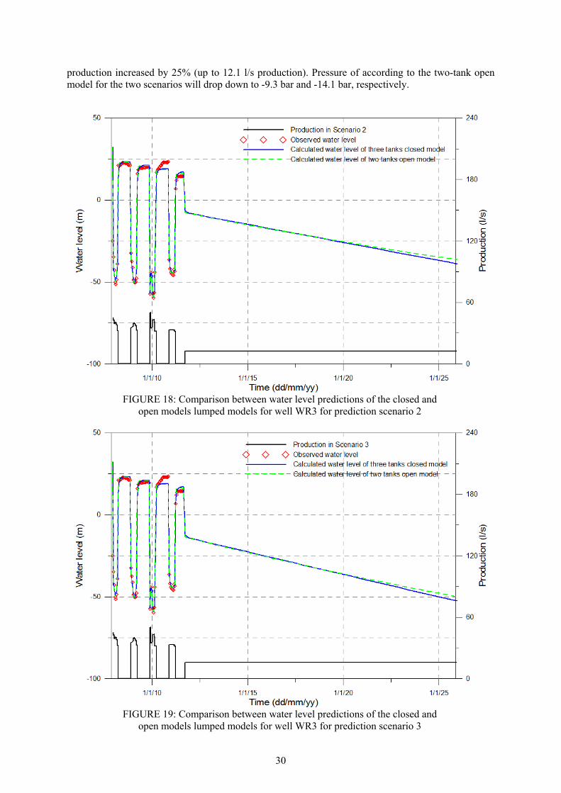
30
production increased by 25% (up to 12.1 l/s production). Pressure of according to the two-tank open model for the two scenarios will drop down to -9.3 bar and -14.1 bar, respectively.
FIGURE 18: Comparison between water level predictions of the closed and
open models lumped models for well WR3 for prediction scenario 2
FIGURE 19: Comparison between water level predictions of the closed and
open models lumped models for well WR3 for prediction scenario 3
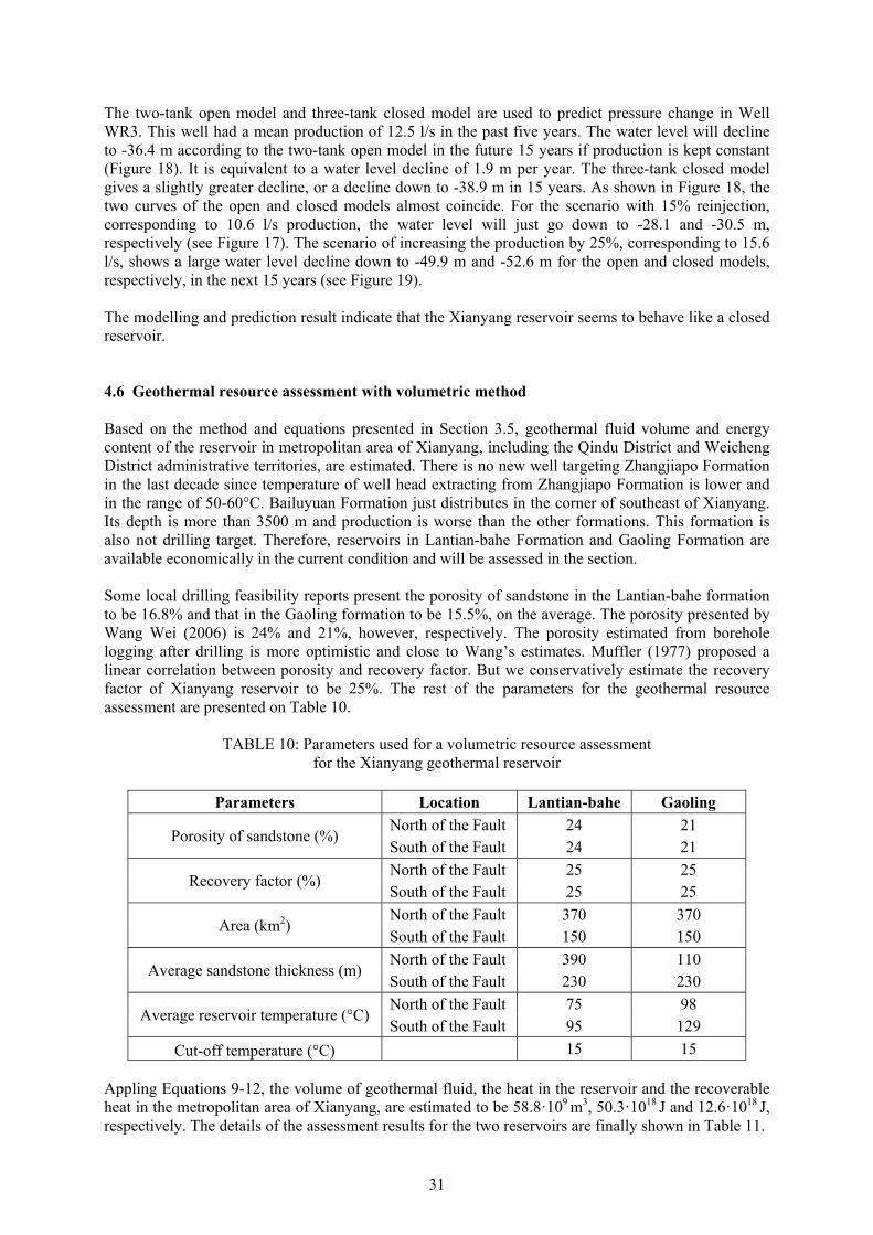
31
The two-tank open model and three-tank closed model are used to predict pressure change in Well WR3. This well had a mean production of 12.5 l/s in the past five years. The water level will decline to -36.4 m according to the two-tank open model in the future 15 years if production is kept constant (Figure 18). It is equivalent to a water level decline of 1.9 m per year. The three-tank closed model gives a slightly greater decline, or a decline down to -38.9 m in 15 years. As shown in Figure 18, the two curves of the open and closed models almost coincide. For the scenario with 15% reinjection, corresponding to 10.6 l/s production, the water level will just go down to -28.1 and -30.5 m, respectively (see Figure 17). The scenario of increasing the production by 25%, corresponding to 15.6 l/s, shows a large water level decline down to -49.9 m and -52.6 m for the open and closed models, respectively, in the next 15 years (see Figure 19). The modelling and prediction result indicate that the Xianyang reservoir seems to behave like a closed reservoir. 4.6 Geothermal resource assessment with volumetric method Based on the method and equations presented in Section 3.5, geothermal fluid volume and energy content of the reservoir in metropolitan area of Xianyang, including the Qindu District and Weicheng District administrative territories, are estimated. There is no new well targeting Zhangjiapo Formation in the last decade since temperature of well head extracting from Zhangjiapo Formation is lower and in the range of 50-60°C. Bailuyuan Formation just distributes in the corner of southeast of Xianyang. Its depth is more than 3500 m and production is worse than the other formations. This formation is also not drilling target. Therefore, reservoirs in Lantian-bahe Formation and Gaoling Formation are available economically in the current condition and will be assessed in the section. Some local drilling feasibility reports present the porosity of sandstone in the Lantian-bahe formation to be 16.8% and that in the Gaoling formation to be 15.5%, on the average. The porosity presented by Wang Wei (2006) is 24% and 21%, however, respectively. The porosity estimated from borehole logging after drilling is more optimistic and close to Wang’s estimates. Muffler (1977) proposed a linear correlation between porosity and recovery factor. But we conservatively estimate the recovery factor of Xianyang reservoir to be 25%. The rest of the parameters for the geothermal resource assessment are presented on Table 10.
TABLE 10: Parameters used for a volumetric resource assessment for the Xianyang geothermal reservoir
Parameters Location Lantian-bahe Gaoling
Porosity of sandstone (%) North of the Fault 24 21 South of the Fault 24 21
Recovery factor (%) North of the Fault 25 25 South of the Fault 25 25
Area (km2) North of the Fault 370 370 South of the Fault 150 150
Average sandstone thickness (m) North of the Fault 390 110 South of the Fault 230 230
Average reservoir temperature (°C) North of the Fault 75 98 South of the Fault 95 129
Cut-off temperature (°C) 15 15 Appling Equations 9-12, the volume of geothermal fluid, the heat in the reservoir and the recoverable heat in the metropolitan area of Xianyang, are estimated to be 58.8·109 m3, 50.3·1018 J and 12.6·1018 J, respectively. The details of the assessment results for the two reservoirs are finally shown in Table 11.
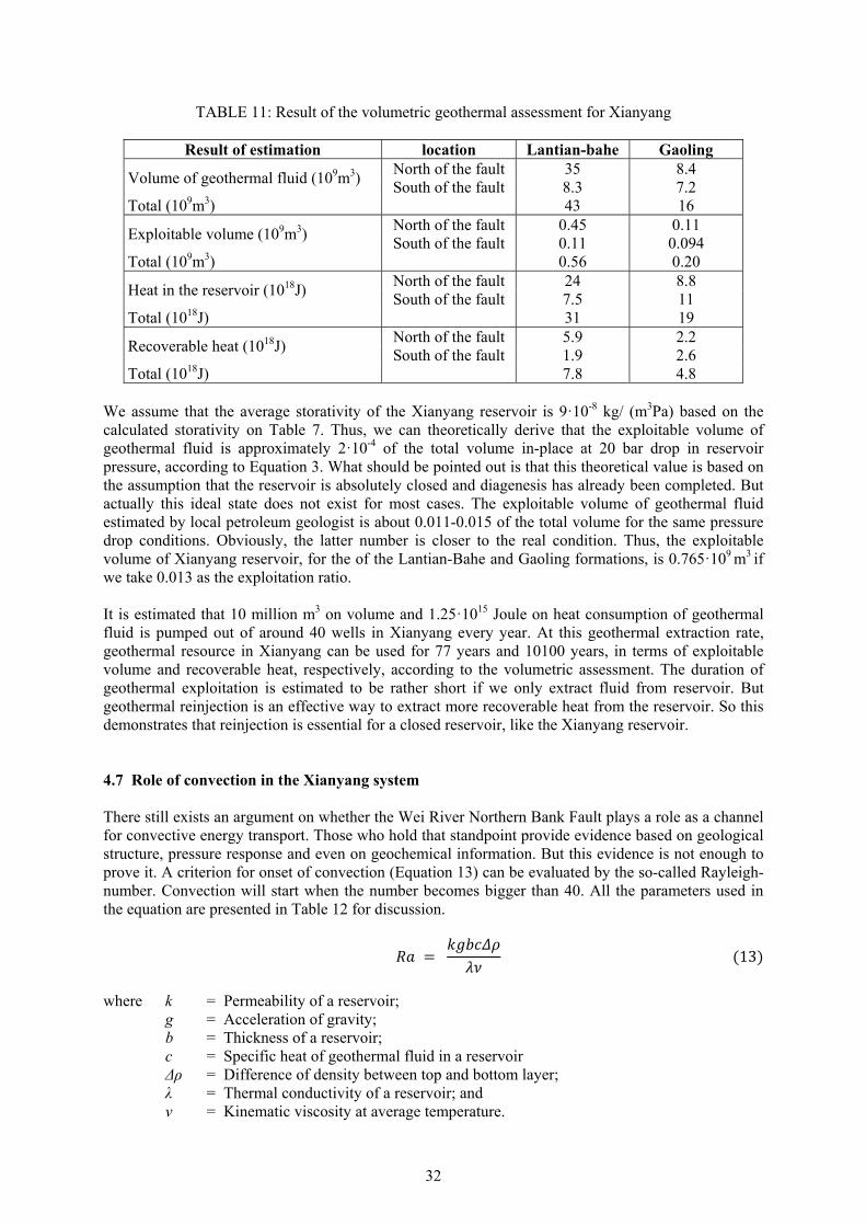
32
TABLE 11: Result of the volumetric geothermal assessment for Xianyang
Result of estimation location Lantian-bahe Gaoling
Volume of geothermal fluid (109m3) North of the fault 35 8.4 South of the fault 8.3 7.2
Total (109m3) 43 16
Exploitable volume (109m3) North of the fault 0.45 0.11 South of the fault 0.11 0.094
Total (109m3) 0.56 0.20
Heat in the reservoir (1018J) North of the fault 24 8.8 South of the fault 7.5 11
Total (1018J) 31 19
Recoverable heat (1018J) North of the fault 5.9 2.2 South of the fault 1.9 2.6
Total (1018J) 7.8 4.8 We assume that the average storativity of the Xianyang reservoir is 9·10-8 kg/ (m3Pa) based on the calculated storativity on Table 7. Thus, we can theoretically derive that the exploitable volume of geothermal fluid is approximately 2·10-4 of the total volume in-place at 20 bar drop in reservoir pressure, according to Equation 3. What should be pointed out is that this theoretical value is based on the assumption that the reservoir is absolutely closed and diagenesis has already been completed. But actually this ideal state does not exist for most cases. The exploitable volume of geothermal fluid estimated by local petroleum geologist is about 0.011-0.015 of the total volume for the same pressure drop conditions. Obviously, the latter number is closer to the real condition. Thus, the exploitable volume of Xianyang reservoir, for the of the Lantian-Bahe and Gaoling formations, is 0.765·109 m3 if we take 0.013 as the exploitation ratio. It is estimated that 10 million m3 on volume and 1.25·1015 Joule on heat consumption of geothermal fluid is pumped out of around 40 wells in Xianyang every year. At this geothermal extraction rate, geothermal resource in Xianyang can be used for 77 years and 10100 years, in terms of exploitable volume and recoverable heat, respectively, according to the volumetric assessment. The duration of geothermal exploitation is estimated to be rather short if we only extract fluid from reservoir. But geothermal reinjection is an effective way to extract more recoverable heat from the reservoir. So this demonstrates that reinjection is essential for a closed reservoir, like the Xianyang reservoir.
4.7 Role of convection in the Xianyang system There still exists an argument on whether the Wei River Northern Bank Fault plays a role as a channel for convective energy transport. Those who hold that standpoint provide evidence based on geological structure, pressure response and even on geochemical information. But this evidence is not enough to prove it. A criterion for onset of convection (Equation 13) can be evaluated by the so-called Rayleigh-number. Convection will start when the number becomes bigger than 40. All the parameters used in the equation are presented in Table 12 for discussion. = (13) where k = Permeability of a reservoir; g = Acceleration of gravity; b = Thickness of a reservoir; c = Specific heat of geothermal fluid in a reservoir Δρ = Difference of density between top and bottom layer; λ = Thermal conductivity of a reservoir; and ν = Kinematic viscosity at average temperature.
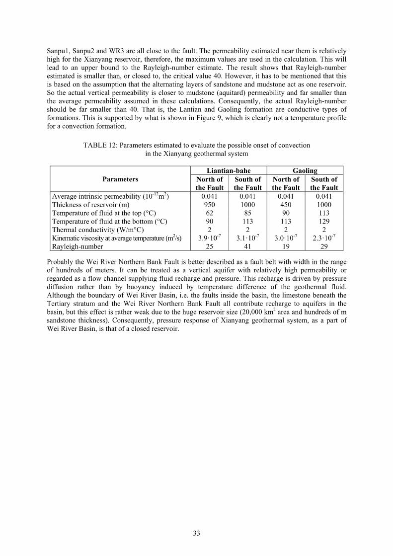
33
Sanpu1, Sanpu2 and WR3 are all close to the fault. The permeability estimated near them is relatively high for the Xianyang reservoir, therefore, the maximum values are used in the calculation. This will lead to an upper bound to the Rayleigh-number estimate. The result shows that Rayleigh-number estimated is smaller than, or closed to, the critical value 40. However, it has to be mentioned that this is based on the assumption that the alternating layers of sandstone and mudstone act as one reservoir. So the actual vertical permeability is closer to mudstone (aquitard) permeability and far smaller than the average permeability assumed in these calculations. Consequently, the actual Rayleigh-number should be far smaller than 40. That is, the Lantian and Gaoling formation are conductive types of formations. This is supported by what is shown in Figure 9, which is clearly not a temperature profile for a convection formation.
Probably the Wei River Northern Bank Fault is better described as a fault belt with width in the range of hundreds of meters. It can be treated as a vertical aquifer with relatively high permeability or regarded as a flow channel supplying fluid recharge and pressure. This recharge is driven by pressure diffusion rather than by buoyancy induced by temperature difference of the geothermal fluid. Although the boundary of Wei River Basin, i.e. the faults inside the basin, the limestone beneath the Tertiary stratum and the Wei River Northern Bank Fault all contribute recharge to aquifers in the basin, but this effect is rather weak due to the huge reservoir size (20,000 km2 area and hundreds of m sandstone thickness). Consequently, pressure response of Xianyang geothermal system, as a part of Wei River Basin, is that of a closed reservoir.
TABLE 12: Parameters estimated to evaluate the possible onset of convection in the Xianyang geothermal system
Parameters Liantian-bahe Gaoling
North of the Fault
South of the Fault
North of the Fault
South of the Fault
Average intrinsic permeability (10-12m2) 0.041 0.041 0.041 0.041 Thickness of reservoir (m) 950 1000 450 1000 Temperature of fluid at the top (°C) 62 85 90 113 Temperature of fluid at the bottom (°C) 90 113 113 129 Thermal conductivity (W/m°C) 2 2 2 2 Kinematic viscosity at average temperature (m2/s) 3.9·10-7 3.1·10-7 3.0·10-7 2.3·10-7 Rayleigh-number 25 41 19 29
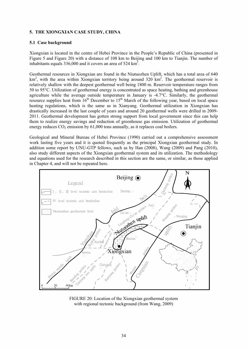
34
5. THE XIONGXIAN CASE STUDY, CHINA 5.1 Case background Xiongxian is located in the centre of Hebei Province in the People’s Republic of China (presented in Figure 5 and Figure 20) with a distance of 108 km to Beijing and 100 km to Tianjin. The number of inhabitants equals 336,000 and it covers an area of 524 km2. Geothermal resources in Xiongxian are found in the Niutuozhen Uplift, which has a total area of 640 km2, with the area within Xiongxian territory being around 320 km2. The geothermal reservoir is relatively shallow with the deepest geothermal well being 1800 m. Reservoir temperature ranges from 50 to 95°C. Utilization of geothermal energy is concentrated as space heating, bathing and greenhouse agriculture while the average outside temperature in January is -4.7°C. Similarly, the geothermal resource supplies heat from 16th December to 15th March of the following year, based on local space heating regulations, which is the same as in Xianyang. Geothermal utilization in Xiongxian has drastically increased in the last couple of years and around 20 geothermal wells were drilled in 2009-2011. Geothermal development has gotten strong support from local government since this can help them to realize energy savings and reduction of greenhouse gas emission. Utilization of geothermal energy reduces CO2 emission by 61,000 tons annually, as it replaces coal boilers. Geological and Mineral Bureau of Hebei Province (1990) carried out a comprehensive assessment work lasting five years and it is quoted frequently as the principal Xiongxian geothermal study. In addition some report by UNU-GTP fellows, such as by Han (2008), Wang (2009) and Pang (2010), also study different aspects of the Xiongxian geothermal system and its utilization. The methodology and equations used for the research described in this section are the same, or similar, as those applied in Chapter 4, and will not be repeated here.
FIGURE 20: Location of the Xiongxian geothermal system with regional tectonic background (from Wang, 2009)
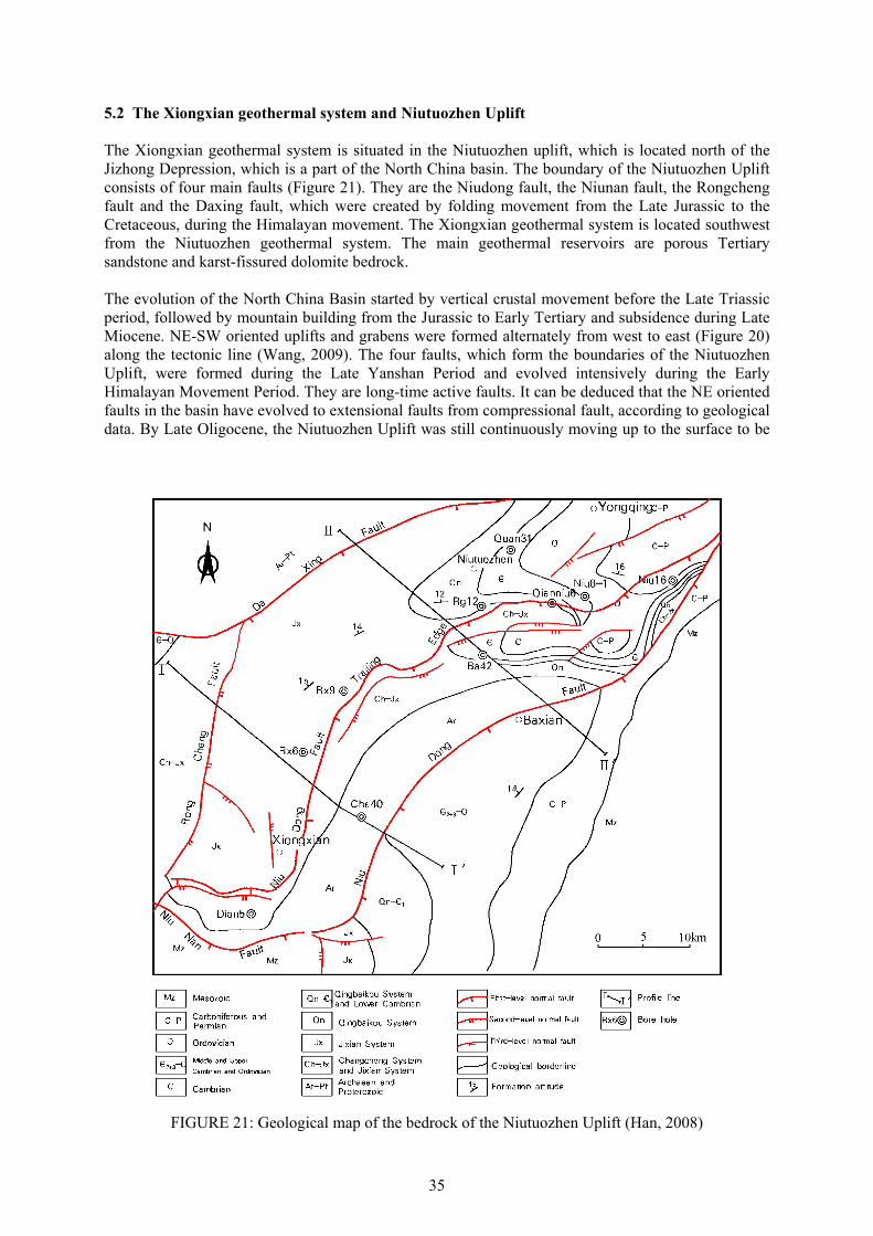
35
5.2 The Xiongxian geothermal system and Niutuozhen Uplift The Xiongxian geothermal system is situated in the Niutuozhen uplift, which is located north of the Jizhong Depression, which is a part of the North China basin. The boundary of the Niutuozhen Uplift consists of four main faults (Figure 21). They are the Niudong fault, the Niunan fault, the Rongcheng fault and the Daxing fault, which were created by folding movement from the Late Jurassic to the Cretaceous, during the Himalayan movement. The Xiongxian geothermal system is located southwest from the Niutuozhen geothermal system. The main geothermal reservoirs are porous Tertiary sandstone and karst-fissured dolomite bedrock. The evolution of the North China Basin started by vertical crustal movement before the Late Triassic period, followed by mountain building from the Jurassic to Early Tertiary and subsidence during Late Miocene. NE-SW oriented uplifts and grabens were formed alternately from west to east (Figure 20) along the tectonic line (Wang, 2009). The four faults, which form the boundaries of the Niutuozhen Uplift, were formed during the Late Yanshan Period and evolved intensively during the Early Himalayan Movement Period. They are long-time active faults. It can be deduced that the NE oriented faults in the basin have evolved to extensional faults from compressional fault, according to geological data. By Late Oligocene, the Niutuozhen Uplift was still continuously moving up to the surface to be
FIGURE 21: Geological map of the bedrock of the Niutuozhen Uplift (Han, 2008)
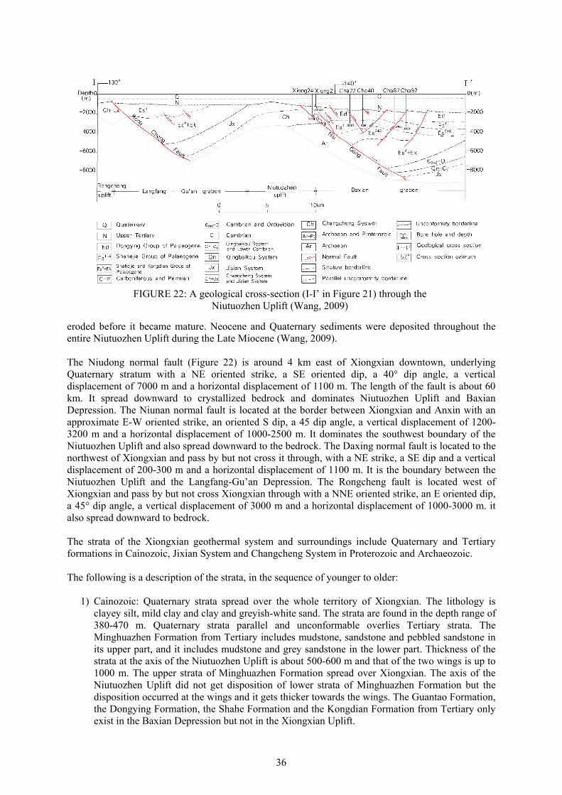
36
eroded before it became mature. Neocene and Quaternary sediments were deposited throughout the entire Niutuozhen Uplift during the Late Miocene (Wang, 2009). The Niudong normal fault (Figure 22) is around 4 km east of Xiongxian downtown, underlying Quaternary stratum with a NE oriented strike, a SE oriented dip, a 40° dip angle, a vertical displacement of 7000 m and a horizontal displacement of 1100 m. The length of the fault is about 60 km. It spread downward to crystallized bedrock and dominates Niutuozhen Uplift and Baxian Depression. The Niunan normal fault is located at the border between Xiongxian and Anxin with an approximate E-W oriented strike, an oriented S dip, a 45 dip angle, a vertical displacement of 1200-3200 m and a horizontal displacement of 1000-2500 m. It dominates the southwest boundary of the Niutuozhen Uplift and also spread downward to the bedrock. The Daxing normal fault is located to the northwest of Xiongxian and pass by but not cross it through, with a NE strike, a SE dip and a vertical displacement of 200-300 m and a horizontal displacement of 1100 m. It is the boundary between the Niutuozhen Uplift and the Langfang-Gu’an Depression. The Rongcheng fault is located west of Xiongxian and pass by but not cross Xiongxian through with a NNE oriented strike, an E oriented dip, a 45° dip angle, a vertical displacement of 3000 m and a horizontal displacement of 1000-3000 m. it also spread downward to bedrock. The strata of the Xiongxian geothermal system and surroundings include Quaternary and Tertiary formations in Cainozoic, Jixian System and Changcheng System in Proterozoic and Archaeozoic. The following is a description of the strata, in the sequence of younger to older:
1) Cainozoic: Quaternary strata spread over the whole territory of Xiongxian. The lithology is clayey silt, mild clay and clay and greyish-white sand. The strata are found in the depth range of 380-470 m. Quaternary strata parallel and unconformable overlies Tertiary strata. The Minghuazhen Formation from Tertiary includes mudstone, sandstone and pebbled sandstone in its upper part, and it includes mudstone and grey sandstone in the lower part. Thickness of the strata at the axis of the Niutuozhen Uplift is about 500-600 m and that of the two wings is up to 1000 m. The upper strata of Minghuazhen Formation spread over Xiongxian. The axis of the Niutuozhen Uplift did not get disposition of lower strata of Minghuazhen Formation but the disposition occurred at the wings and it gets thicker towards the wings. The Guantao Formation, the Dongying Formation, the Shahe Formation and the Kongdian Formation from Tertiary only exist in the Baxian Depression but not in the Xiongxian Uplift.
FIGURE 22: A geological cross-section (I-I’ in Figure 21) through the
Niutuozhen Uplift (Wang, 2009)
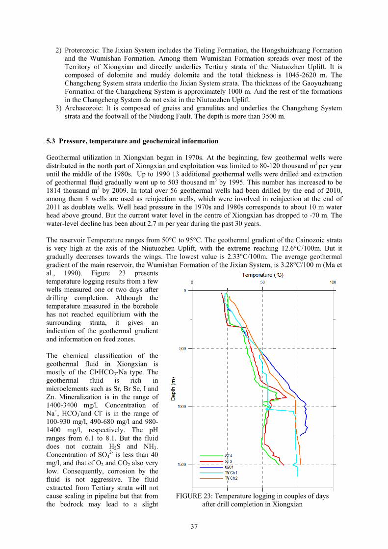
37
2) Proterozoic: The Jixian System includes the Tieling Formation, the Hongshuizhuang Formation and the Wumishan Formation. Among them Wumishan Formation spreads over most of the Territory of Xiongxian and directly underlies Tertiary strata of the Niutuozhen Uplift. It is composed of dolomite and muddy dolomite and the total thickness is 1045-2620 m. The Changcheng System strata underlie the Jixian System strata. The thickness of the Gaoyuzhuang Formation of the Changcheng System is approximately 1000 m. And the rest of the formations in the Changcheng System do not exist in the Niutuozhen Uplift.
3) Archaeozoic: It is composed of gneiss and granulites and underlies the Changcheng System strata and the footwall of the Niudong Fault. The depth is more than 3500 m.
5.3 Pressure, temperature and geochemical information Geothermal utilization in Xiongxian began in 1970s. At the beginning, few geothermal wells were distributed in the north part of Xiongxian and exploitation was limited to 80-120 thousand m3 per year until the middle of the 1980s. Up to 1990 13 additional geothermal wells were drilled and extraction of geothermal fluid gradually went up to 503 thousand m3 by 1995. This number has increased to be 1814 thousand m3 by 2009. In total over 56 geothermal wells had been drilled by the end of 2010, among them 8 wells are used as reinjection wells, which were involved in reinjection at the end of 2011 as doublets wells. Well head pressure in the 1970s and 1980s corresponds to about 10 m water head above ground. But the current water level in the centre of Xiongxian has dropped to -70 m. The water-level decline has been about 2.7 m per year during the past 30 years. The reservoir Temperature ranges from 50°C to 95°C. The geothermal gradient of the Cainozoic strata is very high at the axis of the Niutuozhen Uplift, with the extreme reaching 12.6°C/100m. But it gradually decreases towards the wings. The lowest value is 2.33°C/100m. The average geothermal gradient of the main reservoir, the Wumishan Formation of the Jixian System, is 3.28°C/100 m (Ma et al., 1990). Figure 23 presents temperature logging results from a few wells measured one or two days after drilling completion. Although the temperature measured in the borehole has not reached equilibrium with the surrounding strata, it gives an indication of the geothermal gradient and information on feed zones. The chemical classification of the geothermal fluid in Xiongxian is mostly of the Cl•HCO3-Na type. The geothermal fluid is rich in microelements such as Sr, Br Se, I and Zn. Mineralization is in the range of 1400-3400 mg/l. Concentration of Na+, HCO3
-and Cl- is in the range of 100-930 mg/l, 490-680 mg/l and 980-1400 mg/l, respectively. The pH ranges from 6.1 to 8.1. But the fluid does not contain H2S and NH3. Concentration of SO4
2- is less than 40 mg/l, and that of O2 and CO2 also very low. Consequently, corrosion by the fluid is not aggressive. The fluid extracted from Tertiary strata will not cause scaling in pipeline but that from the bedrock may lead to a slight
FIGURE 23: Temperature logging in couples of days
after drill completion in Xiongxian

38
calcium carbonate scaling. Result of carbon and oxygen isotope research demonstrates that the recharge of the geothermal fluid in Xiongxian originates from precipitation and that the runoff direction is from northeast towards southwest (Ma et al., 1990). 5.4 Reinjection The first reinjection well in Xiongxian, well 0902, was completed in June 2009, with reinjection carried out since 16th November 2009. The geothermal fluid injected is from its doublet well, well 0901. The total reinjection was 480,000 m3 during the first space heating season (form 16th November 2009 to 18th March 2010). The temperature at reinjection wellhead was in the range 32-38°C. The reinjection was done just through the weight of the fluid itself, without any pressure on wellhead, and all the fluid produced from well 0901 is injected into the reservoir. The difference in water level between the wells of the doublet stays around 30 m during reinjection of 43 l/s, due to the good permeability of the reservoir (Figure 24). A tracer test was carried out from January 15th to June 30th 2010. The doublet wells (0901 and 0902) and another four monitoring wells (wells 0307, 0704, 0801 and 0703), which are between 350 m and 2 km away from the reinjection well, were selected for the test. The distance between the doublet-wells is only 350 m. The tracer fluorobenzoic acid was used, with 22 kg injected during the test. More than 600 samples were taken and among them 360 samples were analyzed. The tracer recovery was below the detection limit for all the wells during the test. Pang (2010) analyzed the tracer test results and concluded the following: At most 1% of the tracer flows into the production well, but there is a pressure connection between the doublet-wells, without any direct channel connection. When assuming one channel connecting the wells, a channel porosity of 6%, the distance of 350 m and reinjection rate of 15 kg/s, temperature of production well will starts to decline in 35 years according to Pang‘s analysis and drop by 1.1°C in 100 years. If reinjection rate is 43 kg/s with other conditions the same, temperature will decline in 5 years and drop by 16°C in 100 years, according to the analysis. If there is more than one channel connecting the wells, the temperature decline will start later and the decline will be slower.
5.5 Modelling of the Xiongxian geothermal system 5.5.1 Conceptual model The Xiongxian geothermal system is a part of the Niutuozhen Uplift whose basic structures are shown in Figures 21 and 22. Its conceptual model can be described and summed up as follows:
FIGURE 24: Water level measruements for the well doublet including wells 0901 and 0902 during the 2009-2010 and 2010-2011 heating seasons
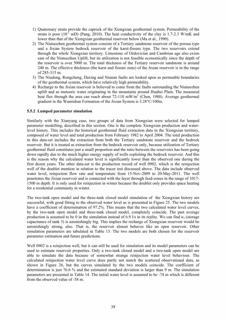
39
1) Quaternary strata provide the caprock of the Xiongxian geothermal system. Permeability of the strata is poor (10-1 mD) (Pang, 2010). The heat conductivity of the clay is 1.7-2.3 W/mK and lower than that of the Xiongxian geothermal reservoir below (Ma et al., 1990).
2) The Niutuozhen geothermal system consists of a Tertiary sandstone reservoir of the porous type and a Jixian System bedrock reservoir of the karst-fissure type. The two reservoirs extend through the whole Xiongxian territory. Limestone of Ordovician and Cambrian age also exists east of the Niutuozhen Uplift, but its utilization is not feasible economically since the depth of the reservoir is over 5000 m. The total thickness of the Tertiary reservoir sandstone is around 240 m. The effective thickness (the karst and fissure zone) of the Jixian reservoir is in the range of 285-315 m.
3) The Niudong, Rongcheng, Daxing and Niunan faults are looked upon as permeable boundaries of the geothermal system, which have relatively high permeability.
4) Recharge to the Jixian reservoir is believed to come from the faults surrounding the Niutuozhen uplift and as meteoric water originating in the mountains around Huabei Plain. The measured heat flux through the area can reach about 72-110 mW/m2 (Chen, 1988). Average geothermal gradient in the Wumishan Formation of the Jixian System is 3.28°C/100m.
5.5.2 Lumped parameter simulation Similarly with the Xianyang case, two groups of data from Xiongxian were selected for lumped parameter modelling, described in this section. One is the complete Xiongxian production and water-level history. This includes the historical geothermal fluid extraction data in the Xiongxian territory, composed of water level and total production from February 1982 to April 2004. The total production in this data-set includes the extraction from both the Tertiary sandstone reservoir and the bedrock reservoir. But it is treated as extraction from the bedrock reservoir only, because utilization of Tertiary geothermal fluid constitutes just a small proportion and the ratio between the reservoirs has been going down rapidly due to the much higher energy supply of wells exploiting the bedrock reservoir. And this is the reason why the calculated water level is significantly lower than the observed one during the first dozen years. The other data-set is the production record of well 0902, which is the reinjection well of the doublet mention in relation to the tracer test discussed above. The data include observed water level, reinjection flow rate and temperature from 15-Nov-2009 to 20-May-2011. The well penetrates the Jixian reservoir and is connected with the layer through feed-zones in the range of 1017-1500 m depth. It is only used for reinjection in winter because the doublet only provides space heating for a residential community in winter. The two-tank open model and the three-tank closed model simulation of the Xiongxian history are successful, with good fitting to the observed water level as is presented in Figure 25. The two models have a coefficient of determination of 97.2%. This means that the two calculated water level curves, by the two-tank open model and three-tank closed model, completely coincide. The past average production is assumed to be 0 in the simulation instead of 6.9 l/s in its reality. We can find κ3 (storage capacitance of tank 3) is astonishingly big. This implies the recharge of Xiongxian reservoir would be astonishingly strong, also. That is, the reservoir almost behaves like an open reservoir. Other simulation parameters are tabulated in Table 13. The two models are both chosen for the reservoir parameter estimation and future predictions. Well 0902 is a reinjection well, but it can still be used for simulation and its model parameters can be used to estimate reservoir properties. Only a two-tank closed model and a two-tank open model are able to simulate the data because of somewhat strange reinjection water level behaviour. The calculated reinjection water level curve does partly not match the scattered observational data, as shown in Figure 26, but the curves simulated by the two models coincide. The coefficient of determination is just 76.6 % and the estimated standard deviation is larger than 9 m. The simulation parameters are presented in Table 14. The initial water level is assumed to be -74 m which is different from the observed value of -58 m.
40
Although the fitting of the data from well 0902 is not so good, its modelling still can be used to indicate reservoir conditions and properties. Furthermore, a single data-series (Xiongxian history data) is not enough to give a comprehensive assessment of the reservoir. 5.5.3 Estimation of reservoir properties The Tertiary and Jixian reservoirs in Xiongxian are typical low temperature geothermal reservoirs with liquid dominated characteristics. Well 0902 is drilled more than 500 m into the Jixian reservoir, and that effective thickness of the Jixian reservoir surrounding the well is estimated to be 335 m Pang, 2010). The fissure and karst evolution in the Jixian reservoir decreases downwards. Therefore it can simply be assumed that the effective thickness is within the top 500 m. Consequently we can treat the well as a fully penetrating well in two-dimensional flow. Therefore, the Xiongxian response history data and the data for well 0902 satisfy the requirements for parameter estimation as described in Section 3.2.
FIGURE 25: Comparison of observed water level and water level calculated by a lumped
parameter model for the complete Xiongxian production history up to 2004
TABLE 13: Parameters of the lumped parameter model used to simulate the Xiongxian production and water-level history data
Parameter Two-tank open model Three-tank closed model
К1 (ms2) 12000 11000 К2 (ms2) 9200 8300 К3 (ms2) 837000 σ1 (ms) 0.0017 0.0018 σ2 (ms) 0.00015 0.00016 Initial water level (m) 0 0 The past average production (l/s) 0 0 Root mean square misfit 3.3 3.3 Estimate of standard deviation 3.4 3.4 Coefficient of determination 97.2% 97.2%
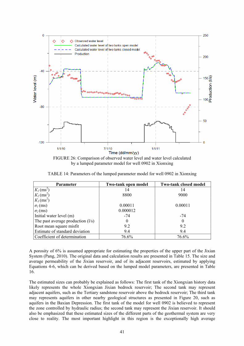
41
A porosity of 6% is assumed appropriate for estimating the properties of the upper part of the Jixian System (Pang, 2010). The original data and calculation results are presented in Table 15. The size and average permeability of the Jixian reservoir, and of its adjacent reservoirs, estimated by applying Equations 4-6, which can be derived based on the lumped model parameters, are presented in Table 16. The estimated sizes can probably be explained as follows: The first tank of the Xiongxian history data likely represents the whole Xiongxian Jixian bedrock reservoir; The second tank may represent adjacent aquifers, such as the Tertiary sandstone reservoir above the bedrock reservoir; The third tank may represents aquifers in other nearby geological structures as presented in Figure 20, such as aquifers in the Baxian Depression. The first tank of the model for well 0902 is believed to represent the zone controlled by hydraulic radius; the second tank may represent the Jixian reservoir. It should also be emphasized that these estimated sizes of the different parts of the geothermal system are very close to reality. The most important highlight in this region is the exceptionally high average
FIGURE 26: Comparison of observed water level and water level calculated
by a lumped parameter model for well 0902 in Xionxing
TABLE 14: Parameters of the lumped parameter model for well 0902 in Xionxing
Parameter Two-tank open model Two-tank closed model К1 (ms2) 14 14 К2 (ms2) 8800 9000 К3 (ms2) σ1 (ms) 0.00011 0.00011 σ2 (ms) 0.000012 Initial water level (m) -74 -74 The past average production (l/s) 0 0 Root mean square misfit 9.2 9.2 Estimate of standard deviation 9.4 9.4 Coefficient of determination 76.6% 76.6%
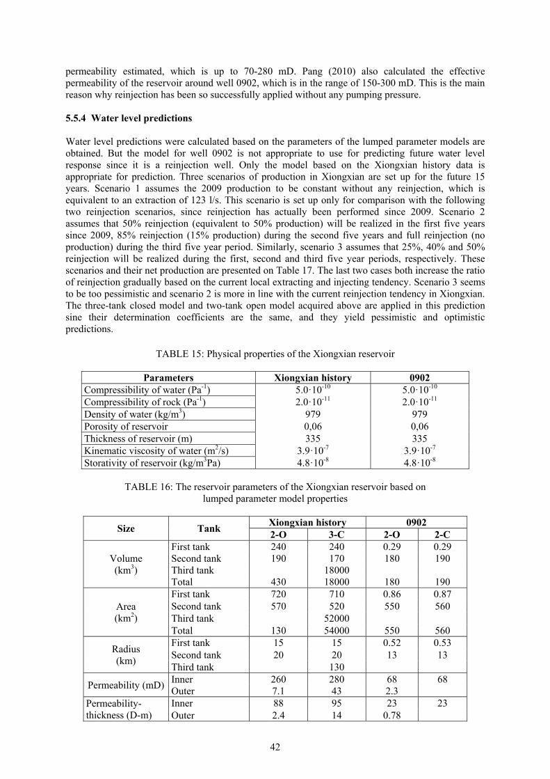
42
permeability estimated, which is up to 70-280 mD. Pang (2010) also calculated the effective permeability of the reservoir around well 0902, which is in the range of 150-300 mD. This is the main reason why reinjection has been so successfully applied without any pumping pressure. 5.5.4 Water level predictions Water level predictions were calculated based on the parameters of the lumped parameter models are obtained. But the model for well 0902 is not appropriate to use for predicting future water level response since it is a reinjection well. Only the model based on the Xiongxian history data is appropriate for prediction. Three scenarios of production in Xiongxian are set up for the future 15 years. Scenario 1 assumes the 2009 production to be constant without any reinjection, which is equivalent to an extraction of 123 l/s. This scenario is set up only for comparison with the following two reinjection scenarios, since reinjection has actually been performed since 2009. Scenario 2 assumes that 50% reinjection (equivalent to 50% production) will be realized in the first five years since 2009, 85% reinjection (15% production) during the second five years and full reinjection (no production) during the third five year period. Similarly, scenario 3 assumes that 25%, 40% and 50% reinjection will be realized during the first, second and third five year periods, respectively. These scenarios and their net production are presented on Table 17. The last two cases both increase the ratio of reinjection gradually based on the current local extracting and injecting tendency. Scenario 3 seems to be too pessimistic and scenario 2 is more in line with the current reinjection tendency in Xiongxian. The three-tank closed model and two-tank open model acquired above are applied in this prediction sine their determination coefficients are the same, and they yield pessimistic and optimistic predictions.
TABLE 15: Physical properties of the Xiongxian reservoir
Parameters Xiongxian history 0902 Compressibility of water (Pa-1) 5.0·10-10 5.0·10-10 Compressibility of rock (Pa-1) 2.0·10-11 2.0·10-11 Density of water (kg/m3) 979 979 Porosity of reservoir 0,06 0,06 Thickness of reservoir (m) 335 335 Kinematic viscosity of water (m2/s) 3.9·10-7 3.9·10-7 Storativity of reservoir (kg/m3Pa) 4.8·10-8 4.8·10-8
TABLE 16: The reservoir parameters of the Xiongxian reservoir based on
lumped parameter model properties
Size Tank Xiongxian history 0902 2-O 3-C 2-O 2-C
Volume (km3)
First tank 240 240 0.29 0.29 Second tank 190 170 180 190 Third tank 18000 Total 430 18000 180 190
Area (km2)
First tank 720 710 0.86 0.87 Second tank 570 520 550 560 Third tank 52000 Total 130 54000 550 560
Radius (km)
First tank 15 15 0.52 0.53 Second tank 20 20 13 13 Third tank 130
Permeability (mD)Inner 260 280 68 68 Outer 7.1 43 2.3
Permeability-thickness (D-m)
Inner 88 95 23 23 Outer 2.4 14 0.78
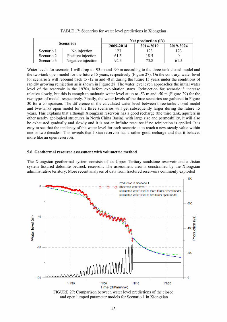
43
Water levels for scenario 1 will drop to -93 m and -90 m according to the three-tank closed model and the two-tank open model for the future 15 years, respectively (Figure 27). On the contrary, water level for scenario 2 will rebound back to -12 m and -8 m during the future 15 years under the conditions of rapidly growing reinjection as is shown in Figure 28. The water level even approaches the initial water level of the reservoir in the 1970s, before exploitation starts. Reinjection for scenario 3 increase relative slowly, but this is enough to maintain water level at up to -53 m and -50 m (Figure 29) for the two types of model, respectively. Finally, the water levels of the three scenarios are gathered in Figure 30 for a comparison. The difference of the calculated water level between three-tanks closed model and two-tanks open model for the three scenarios will get subsequently larger during the future 15 years. This explains that although Xiongxian reservoir has a good recharge (the third tank, aquifers in other nearby geological structures in North China Basin), with large size and permeability, it will also be exhausted gradually and slowly and it is not an infinite resource if no reinjection is applied. It is easy to see that the tendency of the water level for each scenario is to reach a new steady value within one or two decades. This reveals that Jixian reservoir has a rather good recharge and that it behaves more like an open reservoir. 5.6 Geothermal resource assessment with volumetric method The Xiongxian geothermal system consists of an Upper Tertiary sandstone reservoir and a Jixian system fissured dolomite bedrock reservoir. The assessment area is constrained by the Xiongxian administrative territory. More recent analyses of data from fractured reservoirs commonly exploited
TABLE 17: Scenarios for water level predictions in Xiongxian
Scenarios Net production (l/s)
2009-2014 2014-2019 2019-2024 Scenario 1 No injection 123 123 123 Scenario 2 Positive injection 61.5 18.5 0 Scenario 3 Negative injection 92.3 73.8 61.5
FIGURE 27: Comparison between water level predictions of the closed
and open lumped parameter models for Scenario 1 in Xiongxian
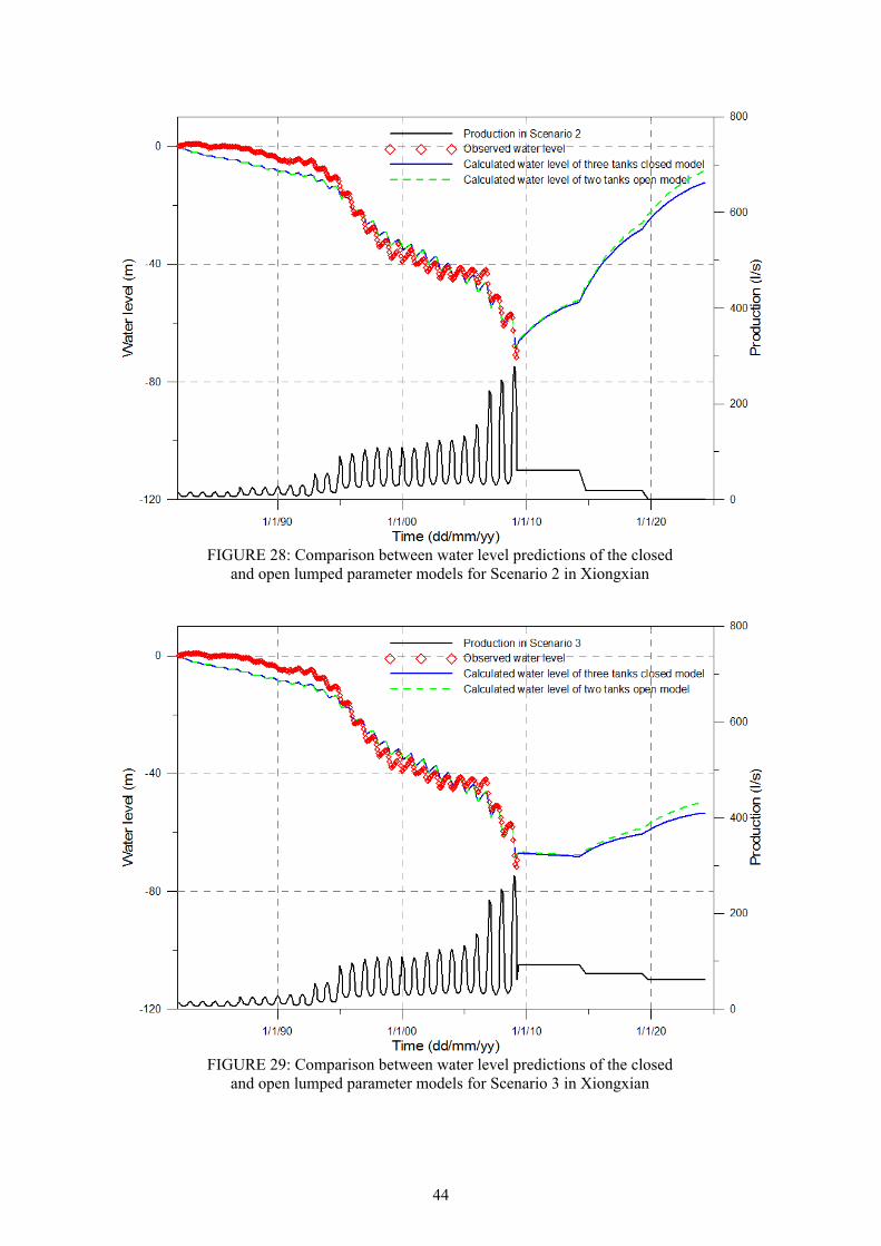
44
FIGURE 28: Comparison between water level predictions of the closed
and open lumped parameter models for Scenario 2 in Xiongxian
FIGURE 29: Comparison between water level predictions of the closed
and open lumped parameter models for Scenario 3 in Xiongxian
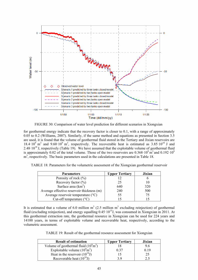
45
for geothermal energy indicate that the recovery factor is closer to 0.1, with a range of approximately 0.05 to 0.2 (Williams, 2007). Similarly, if the same method and equations as presented in Section 3.5 are used, it is found that the volume of geothermal fluid stored in the Tertiary and Jixian reservoirs are 18.4·109 m3 and 9.60·109 m3, respectively. The recoverable heat is estimated as 3.85·1018 J and 2.48·1018 J, respectively (Table 19). We have assumed that the exploitable volume of geothermal fluid is approximately 0.02 of the total volume. Those of the two reservoirs are 0.368·109 m3 and 0.192·109
m3, respectively. The basic parameters used in the calculations are presented in Table 18.
TABLE 18: Parameters for the volumetric assessment of the Xiongxian geothermal reservoir
Parameters Upper Tertiary Jixian Porosity of rock (%) 12 6 Recovery factor (%) 25 10 Surface area (km2) 640 320
Average effective reservoir thickness (m) 240 500 Average reservoir temperature (°C) 55 75
Cut-off temperature (°C) 15 15 It is estimated that a volume of 6.0 million m3 (2.5 million m3 excluding reinjection) of geothermal fluid (excluding reinjection), and energy equalling 0.45·1015J, was consumed in Xiongxian in 2011. At this geothermal extraction rate, the geothermal resource in Xiongxian can be used for 224 years and 14100 years, in terms of exploitable volume and recoverable heat, respectively, according to the volumetric assessment.
TABLE 19: Result of the geothermal resource assessment for Xiongxian
Result of estimation Upper Tertiary Jixian Volume of geothermal fluid (109m3) 18 9.6
Exploitable volume (109m3) 0.37 0.19 Heat in the reservoir (1018J) 15 25
Recoverable heat (1018J) 3.9 2.5
FIGURE 30: Comparison of water level prediction for different scenarios in Xiongxian
46
6. CONCLUSIONS This thesis has reviewed the nature and potential of sedimentary geothermal resources worldwide as well as discussing different aspects of their management during utilization. Two sedimentary systems in China, of quite contrasting nature, are taken as examples and assessed through lumped parameter pressure response modelling and volumetric calculations. These are the Xianyang sandstone system in Central China and the Xiongxian carbonate rock system in North China. The main results of their assessment are presented below. In addition some recommendations on the management of sedimentary geothermal resources in China during utilization are presented in the following chapter. The Xianyang geothermal system, which is a part of the Wei River Basin, is one of the most important conductive geothermal systems in China, , mainly because of its huge size and relatively great single well production. The exploitable geothermal fluid volume stored in the Xianyang territory is estimated to be about 0.77·109 m3 and the recoverable heat to be about 13·1018 J, which can be exploited for 77 and 10100 years, respectively, at the current extraction rate. The Wei River Northern Bank Fault belt is believed to act like a vertical aquifer with a relative high permeability. This fault belt and the limestone formations beneath the Tertiary stratum north of the fault are assumed to contribute a weak recharge for the main production layers of the Xianyang system. But this contribution is greatly diluted by the huge size of the reservoir. The Lantian-Bahe Formation and the Gaoling Group, both consisting of sandstone with high porosity and permeability, are the main production layers. Geothermal fluid in the region has a high mineralization degree and some microelements have a significant effect in balneology. Modelling of pressure changes observed in geothermal wells in Xianyang reflect an average permeability ranging from 2 to 40 mD. The Xianyang reservoir appears to have fairly good internal permeability but a relatively lower external permeability. The modelling also indicates that permeability inside the Xianyang reservoir increases northwards as well as a significant difference between the two sides of the Wei River Northern Bank Fault. A two-tank open and a three-tank closed lumped parameter models are used to simulate the pressure changes observed in three geothermal wells in Xianyang. Consequently, the two models are used to predict pressure changes for different production scenarios. The pressure predictions by the two models are not significantly different and the predicted pressure curves both decline at a fixed rate. This indicates that the sandstone reservoir in Xianyang responds to production more like a closed reservoir. Besides that geochemical information, the estimated conductance between different model tanks, the estimated permeability of different reservoir parts and the pressure predictions, all point to the conclusion that the Xianyang geothermal system is a closed reservoir with a rather weak recharge. The predictions for well Sanpu2 indicate that the pressure will drop 0.75 and 0.66 bar per year for the open and closed models, respectively, if the current production is maintained for the future 15 years. The pressure will drop 0.63 and 0.55 bar per year according to the two models, respectively, if 15% reinjection is maintained. In contrast the pressure is predicted to drop 0.94 and 0.83 bar per year, respectively, if production is increased by 25% without any reinjection. The water level of well WR3 is predicted to decline by 2.0 and 2.2 m per year by the open and closed models, respectively, if the current production is maintained constant for the future 15 years. The water level will decline by 1.7 and 1.9 m per year, respectively, according to the two models, assuming 15% reinjection. However, it will decline by 2.5 and 2.8 m per year according to the two models, respectively, if production is increased by 25%. The Xiongxian geothermal system, which is mostly embedded in the Niutuozhen Uplift of the North China Basin, is in particular noteworthy for its shallow depth and long-term utilization history. It is constrained by four faults which are believed to act as recharge boundaries. The system consists of a Tertiary porous-type sandstone reservoir and a Jixian System karst-fissure-type bedrock reservoir. The Jixian reservoir is rather promising and is believed to have a large potential for future exploitation, partly because reinjection will be easily applied there. The exploitable geothermal fluid volume and
47
recoverable heat stored in Xiongxian territory are estimated to be 0.19·109 m3 and 2.5·1018 J, respectively, being exploitable for 224 and 14100 years, respectively, at the current extraction rate. The most important result obtained for this region is the extremely high internal permeability of up to 280 mD, estimated by modelling pressure changes. This is also one of the reasons why reinjection can be so easily applied without any pumping pressure. The external permeability of the geothermal system is estimated to be around 10 - 40 mD. Predictions by lumped parameter models simulating the whole production and response history of the Xiongxian system indicate that water level will approach a new equilibrium at -90 m and -93 m according to the open and closed models, respectively, during the future 15 years at the current production rate, if reinjection is not applied, due to the apparently open boundaries. It is predicted to rebound rapidly to -10 m for a prediction assuming a positive reinjection scenario (reinjection increasing to 85%), according to the two models. Water level predictions for the negative reinjection scenario (reinjection increasing to 50%) indicate that the water level will stabilize at around -50 m. Pressure predictions by the two models for Xiongxian are qualitatively not very different, but the difference from the Xianyang case is that the predicted pressure approaches stable levels instead of going down at a fixed rate. The pressure predictions together with the conductance between different model tanks and the estimated permeability of different reservoir parts, all obviously indicate that the Jixian reservoir in Xiongxian is an open geothermal reservoir.
48
7. RECOMMENDATIONS FOR MANAGEMENT OF SEDIMENTARY GEOTHERMAL RESOURCES IN CHINA Based on the review of the general nature and utilization experience of sedimentary geothermal resources worldwide presented in this thesis, as well as the results of the assessment of the two sedimentary systems in China also presented, a number of recommendations are put forward. These are the following: Based on an analysis of geothermal resources, economy, population and climate, the prospects
for geothermal development in China is seen as geothermal power generation and cascaded utilization in the southwest and west, space heating in the north and northeast as well as multi-purpose utilization in the southeast.
Geothermal resources and oil and gas resources are both distributed in sedimentary strata. Some
even coexist in the same reservoir. Therefore, strengthening the cooperation with oil and gas enterprises and institutions and sharing data and research achievements would be extremely valuable for the geothermal industry, as the oil and gas counterpart. This would e.g. accelerate various geothermal resource studies.
Although it has long been recommended that the response of the Xianyang geothermal system
to production be carefully monitored and collected, it is, however, still hard to accomplish. A temporary compromise is proposed, which involves selecting several geothermal well as specific monitoring wells in a given geothermal system based on reservoir size and complexity. This is probably a more realistic approach until monitoring of all wells becomes a reality. This applies to all geothermal resources being utilized in China.
The result presented above that the Xianyang geothermal system behaves approximately as a
closed system demonstrates that reinjection should be put into execution, as an essential part of the management of the Xianyang geothermal resource, as soon as possible. This is extremely important because the extraction of geothermal fluid is increasing year by year since the space heating market is growing rapidly. Sandstone reinjection is delicate because of the clogging up of the reservoir next to reinjection wells. Therefore a detail geochemical analysis is important before reinjection is initiated. And chemical treatment and efficient physical filtration on surface are necessary. The same recommendation applies to most sandstone geothermal systems being utilized in China.
The interval between production and reinjection wells in Xiongxian needs to be increased to
avoid the possibility of premature production well cooling. The same applies to other carbonate rock systems where reinjection and production well spacing is short.
The research and exploration of the geothermal resource in the limestone in Xianyang should be
increased, and exploitation and reinjection in the strata attempted. This could enlarge geothermal reserves in the area and perhaps provide a good way to avoid the difficulty of sandstone reinjection. Carbonate rocks can also be drilled into, in terms of economic depth, at the edges and the uplift of some other sedimentary basins. Therefore, more emphasis should be put on attempts to exploit more carbonate rock strata to enhance the geothermal potential in China.
49
REFERENCES Axelsson, G., 1989: Simulation of pressure response data from geothermal reservoir by lumped parameter models. Proceedings of the 14th Workshop on Geothermal Reservoir Engineering, Stanford University, California, 257-263. Axelsson, G., and Arason, P., 1992: LUMPFIT, Automated simulation of pressure changes in hydrological reservoirs. Version 3.1, User’s guide. Orkustofnun, Reykjavík, 32 pp. Axelsson, G., and Ármannsson, H., 2005: Characteristics and potential of geothermal resources in Xianyang, Shaanxi Province, China. ÍSOR, Reykjavík, report ÍSOR05127, 36 pp. Chen, W., Chen, J., Yun, Q., Xu, S., Huang, J. and Yao, Z., 1977: Geological results report of petroleum general investigation of Fin-Wei Basin. The Third General Investigation Exploration Team, Xianyang, China (in Chinese), 358 pp. Chen M., 1988: The geothermal field in Huabei plain, China (in Chinese). Science Publishing Ltd., Beijing, 40 pp. Fridleifsson, I.B., Bertani, R., Huenges, E., Lund, J.W., Ragnarsson, A., and Rybach, L., 2008: The possible role and contribution of geothermal energy to the mitigation change. Proceeding of IPCC Scoping Meeting on Renewable Energy Sources, Luebeck, Germany, 20-25 January 2008, 59-80. Gong, B., Liang, H., Xin, S., and Li, K., 2011: Effect of water injection on reservoir temperature during power generation in oil fields. Proceedings of the 36th Workshop on geothermal Reservoir Engineerin,g Stanford University, Stanford, California, 7 pp. Han, Z., 2008: Reservoir assessment of the Xiongxian geothermal field, Hebei Province, China. Report 19 in: Geothermal training in Iceland 2008. UNU-GTP, Iceland, 281-304. Huang, J., 2009: Assessment of geothermal resources in Xianyang, Shaanxi Province, China: Lumped parameter modelling and predictions. Report 12 in: Geothermal training in Iceland 2009. UNU-GTP, Iceland, 179-198. Kepinska, B., 2008: Geothermal resources and use for heating in Europe. Workshop for Decision Makers on Direct Heating Use of Geothermal Resources in Asia, UNU-GTP, TBLRREM and TBGMED, in Tianjin, China, 11-18 May 2008, 22 pp. Kang, F., 2010: Sustainable Development of Geothermal Resources in China. Proceedings of World Geothermal Congress 2010, Bali, Indonesia, 5 pp. Kang, F., Xu, J., Liu, Z., and Liang, G., 2005: Geothermal resources potential assessment in Shandong Province, China. Proceedings of World Geothermal Congress 2005, Antalya, Turkey, 5 pp. Li, H., 2008: Geothermal utilization and development in Hebei Province. The 30th Anniversary Workshop of UNU-GTP, UNU-GTP, Iceland, 8 pp. Liu, J., 2008: Background, history and status of geothermal use in Beijing. Workshop for Decision Makers on Direct Heating Use of Geothermal Resources in Asia, UNU-GTP, TBLRREM and TBGMED, Tianjin, China, 11-18 May 2008, 10 pp. Liu, J., and Yan, Y., 2004: Geothermal resources and direct use in the area of Beijing. Proceedings of the 6th Asian Geothermal Symposium, 25-31. Liu, J., Wei, L., Ye, C., Sun, Y., and Yin, M., 2010: Management of geothermal resources in Beijing. Proceedings of World Geothermal Congress 2010, Bali, Indonesia, 5 pp.
50
Lopez, S., Hamm, V., Brun, M.L., Schaper, L., Boissier, F., Cotiche, C., and Giuglaris, E., 2010: 40 years of Dogger aquifer management in Ile-de-France, Paris Basin, France. Geothermics, 39, 339-356. Ma J., Cai, H., and Zhang, D., 1990: The investigation report of Niutuozhen geothermal field, Hebei Province, China. Geological and Mineral Bureau of Hebei Province (in Chinese), 216 pp. Pang, J., 2010: Reinjection into well ST0902 and tracer testing in the Xiongxian geothermal field, Hebei Province, China. Report 25 in: Geothermal training in Iceland 2010. UNU-GTP, Iceland, 493-524. Pang, Z., Yang, F., Huang, T., Duan, Z., 2010: Genesis analysis of geothermal systems in Guanzhong Basin of China with implications on sustainable geothermal resources development. Proceedings of World Geothermal Congress 2010, Bali, Indonesia, 8 pp. Qin, D., Turner, J.V., and Pang, Z., 2005a: Hydrochemistry and groundwater circulation in the Xi’an geothermal field, China. Geothermics, 34, 471-494. Qin, D., Turner, J.V., Han, L., and Pang, Z., 2005b: Inferring young groundwater from deep geothermal water using CFCs and isotope data: implication for circulation of groundwater in the Xi’an geothermal field, Shaanxi Province, China. Proceedings of World Geothermal Congress 2005, Antalya, Turkey, 7 pp. Seibt, P., and Wolfgramm, M., 2008: Practical experience in the reinjection of thermal waters into sandstone. Workshop for Decision Makers on Direct Heating Use of Geothermal Resources in Asia, UNU-GTP, TBLRREM and TBGMED, in Tianjin, China, 18 pp. Szanyi, J., and Kovács, B., 2010: Utilization of geothermal systems in South-East Hungary. Geothermics, 39, 357–364. Tao, Q., 2008: Strategy and management of exploration and development of geothermal resources in China. Workshop for Decision Makers on Direct Heating Use of Geothermal Resources in Asia, UNU-GTP, TBLRREM and TBGMED, in Tianjin, China, 9 pp. Wang, K., 2008: Lectures on geothermal areas in China. UNU-GTP, Iceland, lecture, 122 pp. Wang, K., 2010: General characteristics of geothermal areas in China. Proceedings of World Geothermal Congress 2010, Bali, Indonesia, 4 pp. Wang, S., 2009: Three-dimensional model of the Niutuozhen geothermal system, Hebei Province, China. Report 25 in: Geothermal training in Iceland 2009. UNU-GTP, Iceland, 559-583. Wang, W., 2006: Geochemical study of the Xianyang low-temperature geothermal field, Shaanxi Province, China. Report 22 in: Geothermal training in Iceland 2006. UNU-GTP, Iceland, 501-522. Wang, L., and Lin, L., 2010: Discussion on reinjection geothermal fluids into sandstones in Tianjin P.R.C. Proceedings of World Geothermal Congress 2010, Bali, Indonesia, 4 pp. Williams, C.F., 2007: Updated methods for estimating recovery factors for geothermal resources. Proceedings of the 32nd Workshop on Geothermal Reservoir Engineering, Stanford University, Stanford, California, 7 pp. Zhang, B., 2005: Geothermal resources in China. Proceedings of World Geothermal Congress 2005, Antalya, Turkey, 3 pp.
51
Zhang, B., 2010: Geothermal development in Tianjin of China. Proceedings of World Geothermal Congress 2010, Bali, Indonesia, 3 pp. Zhang, F., Sun, Q., Zou, Y., Gao, X., and Liu, M., 2007: Reservoir assessment of Fengdong area in S-Xianyang. The Third General Investigation Exploration Team, Xianyang, China (in Chinese), 46 pp. Zou, Y., 2007: Sedimentary facies and neotectonics movement in Wei river basin. Report (in Chinese), 4 pp. Zou, Y., Zhang, F., and Sun, Q., 2008: Geothermal well WR5, Wujiacun, Xianyang, feasibility study report. Report (in Chinese), 34 pp.