Embed Size (px)
Citation preview
Assessing the impact of climatechange on agriculture in QuangNam Province, Viet Nam using
modeling approachHuong Thi Lan Huynh, Lieu Nguyen Thi and Nguyen Dinh Hoang
Vietnam Institute of Meteorology, Hydrology and Climate Change, Hanoi, Vietnam
AbstractPurpose – This study aims to evaluate the impact of climate change on some specific areas of agriculturalproduction in Quang Nam Province, including assessing the possibility of losing agricultural land owing tosea level rise; assessing the impact on rice productivity; and, assessing the impact on crop water demand.Design/methodology/approach – This study used the method of collecting and processing statisticsdata; method of analysis, comparison and evaluation; method of geographic information system; method ofusing mathematical model; andmethod of professional solution, to assess the impacts of climate change.Findings – Evaluation results in Quang Nam Province show that, by the end of the 21st century, winter–spring rice productivity may decrease by 33%, while summer–autumn rice productivity may decrease by49%. Under representative concentration pathway (RCP) 4.5 scenario, water demand increases by 31.1%compared to the baseline period, of which the winter–spring crop increases by 28.4%, and the summer–autumn crop increased by 34.3%. Under RCP 8.5 scenario, water demand increases by 54.1% compared to thebaseline period, of which the winter–spring crop increases by 46.7%, and the summer–autumn crop increasedby 63.1%. The area of agricultural land likely to be inundated by sea level rise at 50 cm is 418.32 ha, and at80 cm, it is 637.07 ha.Originality/value – To propose adaptation solution to avoid the impacts of climate change on agriculture,it is necessary to consider about the impact on losing land for agriculture, the impact on rice productivity,assess the impact on crop water demand and other. The result of this assessment is useful for policymakersfor forming the agriculture development plan.
Keywords Climate change, Agricultural land, Rice productivity, Water demand
Paper type Case study
1. IntroductionAccording to a report by the Intergovernmental Panel on Climate Change (IPCC), globalaverage temperature and sea level have increased rapidly over the past 100 years, especiallyin the past 25 years. Temperatures have tended to increase at most observation stations,
© Huong Thi Lan Huynh, Lieu Nguyen Thi and Nguyen Dinh Hoang. Published by EmeraldPublishing Limited. This article is published under the Creative Commons Attribution (CC BY 4.0) licence.Anyone may reproduce, distribute, translate and create derivative works of this article (for bothcommercial & non-commercial purposes), subject to full attribution to the original publication andauthors. The full terms of this licence may be seen at http://creativecommons.org/licences/by/4.0/legalcode
This paper was completed within the framework of the state-level science and technologyresearch project: “Researching scientific and technological solutions for multidisaster management,developing tools to support decision-making and coping with multiple natural disasters, pilotapplication to the Central coastal region under the Program: Scientific and technological research forenvironmental protection and natural disaster prevention” Code: KC.08/16–20.
Impact ofclimate changeon agriculture
757
Received 30March 2020Revised 18 June 2020
6 August 202012 September 2020
Accepted 21 September 2020
International Journal of ClimateChange Strategies and
ManagementVol. 12 No. 5, 2020
pp. 757-771EmeraldPublishingLimited
1756-8692DOI 10.1108/IJCCSM-03-2020-0027
The current issue and full text archive of this journal is available on Emerald Insight at:https://www.emerald.com/insight/1756-8692.htm
increasing rapidly in recent decades (IPCC, 2007). In Viet Nam, the average annualtemperature during the period of 1958-2014 increased by about 0.62 Celsius degree, in theperiod (1985-2014), the temperature increased by about 0.42 degree. On average, the waterlevel at the Vietnamese naval stations tends to increase significantly with an increase ofabout 2.45mm/year. The phenomenon of El Niño and La Niña increasingly strongly affectsthe climate and weather of Viet Nam. Climate change has really made natural disasters,especially typhoons, floods and droughts, increasingly fierce.
Agriculture around the world has been identified as an important and significantcontributor to the economy. For Viet Nam, agriculture has considered a key and importanteconomic sector with more than 70% of the population working in agriculture and living inrural areas. In recent years, under the impact of climate change, the frequency and intensityof natural disasters have been increasing, causing great losses of people, assets,infrastructure, economy, culture, society and bad impact on the environment.
Climate change is increasingly seriously affecting production, life and the environmentworldwide; making comprehensive and profound changes in global development andsecurity processes such as food, water and energy, social, cultural, diplomatic andcommercial issues. Agriculture is one of the sector that most vulnerable to climate change.Therefore, assessing the impact of climate change on agricultural production is one of theimportant issues to support the proposal and implementation of climate change responsesolutions to develop agriculture in a sustainable way.
The main impacts of climate change on agricultural production in ecological regions ofthe world are reflected in the following aspects (IPCC, 2007; Hoa, 2013):
� The increase in temperature will affect the ability to generate and develop crops andanimals leading to productivity and output change.
� Increasing temperature will reduce water resources, many areas will have no waterand will not be able to continue farming, leading to a decrease in cultivated area.
� An increase in temperature will cause the ice to melt, leading to more invasive,flooded and mangrove lands.
� Changing climate conditions will reduce biodiversity, cause ecological imbalance,especially natural disasters, natural enemies and affect plant growth and diseasedevelopment.
� Extreme, irregular weather phenomena such as early, late, or unseasonal rains willmake it difficult to arrange planting seasons and crop structure, causing significantdamage to the agricultural production.
The year of 1998 was considered the hottest year and had severe damage caused by naturaldisasters such as typhoons in central America; in China, India and Bangladesh, Argentinaand Paraguay, floods directly cause serious damage to crops. In addition, little andunseasonal rainfall indirectly affect crop failure in Maharashtra, India.
The European Union experienced a prolonged heat wave in the summer of 2003. Othercountries such as Bihar, western Bangladesh, Orissa and Andhra also suffered a hot andharsh summer. In contrast, India experienced a severe cold season from December 2002 toFebruary 2003. Some areas such as Jammu, Punjab, Himachal, Uttar Pradesh and somecountries in the western north experienced an unpredictable cold winter. These changescause crop failures between 10% and 100% in agriculture and cause even more damage toregions with cold and prolonged climates (Samra et al., 2004).
The rising temperature in March 2004 also had a very negative impact on crops suchas wheat, apples, peaches, potatoes and herbs throughout Himachal Pradesh state in India.
IJCCSM12,5
758

The highest temperature in the whole of Himachal Pradesh state in March was recordedhigher from 2.1 to 7.9 Celsius degree. The amount of crop loss is estimated at 20% to 60%depending on the type of crop (Prasad and Rana, 2006). In addition, due to the increase intemperature from 1 to 3 degree from mid-February to mid-March 2004, in the central regionof Kerala, India, the cocoa crop decreased by 39%when compared to 2003 (NIAEM, 2012).
In Haryana and Punjab, India, in 2007, unseasonal rain and hail destroyed the entirewheat crop with an area of 15,000 hectares. Also in this year, during the monsoon season inAugust, heavy rains inundated many countries including India and Bangladesh. ByOctober, heavy rains caused serious flooding in Andhra Pradesh, Karnataka and Kerala, so2007 was considered a year of flooding in India. Similar to India, severe flooding alsooccurred in some countries such as Algeria, Uganda, Sudan, Bangladesh causing severecrop failures (NIAEM, 2012).
In Beijing, China, the temperature soared to16 Celsius degree in February 2007, thehighest recorded by the meteorological agency since 1840 and then followed by the coldestand most snowfall in the winter of 2008. A three-week heavy snowfall near mid-February2008, caused 104 million hectares of crop damage and about 22,000 houses were destroyedwith estimated losses of up to $7.5bn (NIAEM, 2012).
Along with heavy rains and floods, sea level rise are also obvious manifestations ofclimate change. Each year, the sea level rises by less than 1mm along the coast of India. Sealevel rise can cause the coastal strip of the region to disappear, altering ocean biodiversityand threatening coral habitats. Especially, when the water is high due to typhoons,combined with strong winds and high tides, the phenomenon of extreme sea level rise willgreatly affect the cultivated areas (NIAEM, 2012).
According to the United Nations Food and Agriculture Organization (FAO) report, India issuffering 125 million tons of grain losses. Equivalent to 18% of the country’s total productvolume due to climate change effects as of 2015. Climate change also reduces grain productionworldwide, leaving 400 million people facing hunger and 3 billion people affected by floods andclean water shortages. Crop losses due to climate change may lead to an increase in the numberof undernourished people, greatly affecting the process of hunger eradication, povertyalleviation and food security. The region with the most severe climate change impacts issub-Saharan Africa, which has the least ability to adapt to climate change and must increasefood imports to make up the shortage. For example, in 2004 and 2005, 24 sub-Saharan Africancountries faced a state of emergency over food shortages caused by a combination of locustsand drought. In addition, hot and dry weather in the USA and drought in some parts of theEuropean Union reduced grain production in 2005 when compared to 2004 (NIAEM, 2012).
Climate change has a great impact on India’s economy because it is an agricultural country,dependentmainly on cultivation. In 2002, a typical example showed that India’s food productiondepended heavily on the rainy season, but due to climate change during this period, droughtoccurred throughout the territory of India. The rainfall deficit is about 19% of the multi-yearaverage, resulting in 29% of India’s territory being affected by drought, so that food productionwas seriously affected and decreased by 19.1% compared to the same period (NIAEM, 2012).
Viet Nam is an agricultural country, so that, the agricultural economy has always played animportant role in Viet Nam’s socio-economic development with a contribution of about 20% ofgross domestic product (GDP) (Nghia, 2017; Lan, 2019). The majority of the poor in Viet Namrelies on agriculture. Agricultural and rural areas account for nearly 70% of the country’spopulation. The two major deltas of Viet Nam, the Red River Delta and the Mekong Delta, arenow providing food for the whole country and for world exports (Natural Resources andEnvironment, 2018), Viet Nam is ranked by the United Nations Development Organization asone of the countries most affected andmost vulnerable to climate change (Lan, 2019).
Impact ofclimate changeon agriculture
759
According to research results of the University of Copenhagen, Viet Nam’s economy willmaintain and continue to grow at a rate of 5.4% per year in the period of 2007-2050 andagriculture’s contribution to GDP will decrease from 16% to only 7.6%. Sea level rise scenariosshow that, although the impacts are mild, they also cause GDP in the period 2046-2050 todecrease from 0%–2.5%. Specifically, if GDP is forecast to reach greater than $500bn by 2050,the value of damage due to climate change will be around $40bn (Lan, 2019).
Climate change and extreme natural disasters are no longer a threat that actually existsin Viet Nam (Nhat, 2019). Climate change has been strongly impacting on Viet Nam’sagriculture sector, such as reducing agricultural land, increasing drought and pests, puttingenormous pressure on the development of the cultivation process (Lac, 2020). In 2018,natural disasters have occurred continuously across the country in Viet Namwith 13 stormsand tropical depressions; 212 thunderstorms and tornadoes of lightning; 14 flash floods andlandslides; nine strong winds on the sea; four cold spells, damaging cold; 11 heat waves; 23episodes of cold air; 30 heavy rains on a large scale; major floods in the upstream of theMekong River after seven years since 2011, the spring tide has surpassed the historicallandmarks in the Southern provinces; river bank erosion, severe coastal erosion in thecentral region and the Mekong Delta, causing serious economic losses with an estimatedVND 20,000bn and making 218 people dead and missing (Nhat, 2019). Natural disasters andextreme weather events tend to increase, causing great disadvantages to agriculturalproduction. Strong storms damaged irrigation works, dike systems and devastated crops.Severe cold weather can cause severe damage to newly planted rice and rice. Severe droughtcauses great losses for rice and other crops such as coffee, pepper, avocado and cashew(Thanh and Viet, 2014).
Climate change makes the water demand for agriculture increase, while the water supplycapacity of irrigation works cannot fully meet the demand for irrigation water. The shortageof irrigation water for crops, especially rice, is expected to worsen. Rainfall change anduneven distribution adversely affect the yield and productivity of rice and other crops.Unusual heavy rains and unseasonal rain can cause flooding, leading to inundation of rice,crops and crops (Thanh and Viet, 2014). In addition, saline intrusion into the interior has ledto a shortage of agricultural land and salinity affected negatively food security. The area ofsaline soils in theMekong Delta is at increasing risk. If the sea level rises by 100 cm, MekongDelta and Ho Chi Minh City will be at the risk of losing 40.5% of the total rice production ofthe region (Thanh and Viet, 2014).
In recent years, droughts and heat waves have been continuously and continuouslyoccurring in all regions of the country, showing an increasing level of influence of climatechange. Drought reduces 20%–30% of crop productivity, food production, leading to seriousimpacts on people’s livestock and daily life (Nhat, 2019; Lac, 2020). In addition, increasedtemperatures and drought leading to lack of water will greatly affect the distribution ofcrops, especially reducing productivity. Specifically, the rice yield of the spring crop tendedto decrease more sharply than that of the spring crop; and winter maize yield tends toincrease in the Northern Delta and decrease in the Central and Southern regions. It isestimated that the yield of spring rice in the Red River Delta could be reduced by about 3.7%in 2020 and by 16.5% in 2070; Summer rice productivity will decrease by 1% in 2020 and by5% by 2070 if effective and timely measures are not taken (Dat et al., 2019).
Flooding due to sea level rise will gradually reduce agricultural land. If the sea level risesby 1m, it is estimated that 40% of the Mekong Delta area, 11% of the Red River Delta areaand 3% of the other provinces’ areas will be flooded (Viet Nam Ministry of NaturalResources and Environment, 2016). Currently, Viet Nam’s cultivated land area is about 9.4million hectares, of which, 4 million hectares is rice-growing land (Dat et al., 2019).
IJCCSM12,5
760
According to research and forecasts by the IPCC and the World Bank, in Viet Nam, if thewater level rises to 1m, 0.3–0.5 million ha in the Red River will be flooded (Nhat, 2019). On anational scale, Viet Nam will lose about 2 million hectares of rice land, equivalent to about50% if the sea level rises by 1m (Dat et al., 2019).
Climate change also increases saline intrusion in coastal areas, causing agricultural landarea to be lost, especially in the Mekong Delta (Dat et al., 2019). Based on a multi-yeardatabase, the Can Tho City Center for Natural Resources and Environment Monitoringpredicts that, by the year 2050, in the dry season, salinity of 1% could penetrate into CanTho more often with a depth of 0.5m (Southern Institute of Agricultural Science andTechnology, 2013). According to Dat et al. (2019), if the sea level rises by 1m, about1.77 million hectares of land will be contaminated with alum and salinity, accounting forabout 45% of the land area in the Mekong Delta and about 85% of the people in the MekongDelta region will need agricultural support.
Climate change also increases natural disasters, causing crop yields and real yields todecline. According to the report of the Asian Development Bank, if the temperature increasesby 1 Celsius degree, the rice yield will decrease by about 10%, this situation will seriouslythreaten national and food security and affect the tens of millions of people across the country.According to calculations and forecasts of the Institute of Agricultural Environment, climatechange causes the yield of some key plants to decline sharply. Specifically, the yield of thespring crop will decrease by 0.41 tons/ha by 2030 and 0.72 tons/ha by 2050. The yield of maizeis likely to decrease by 0.44 tons/ha by 2030 and 0.78 tons/ha by 2050. By 2100, if the sea levelrises by 100 cm, the Mekong Delta is likely to be inundated about 89,473ha, corresponding tothe area that will lose about 7.6 million tons of rice/year. Viet Nam will be in serious danger offood shortage and increase poverty rate (Nhat, 2019).
In addition, climate change can affect seasons, change the crop patterns, increaseepidemics and reduce productivity and production (Dat et al., 2019).
Losing farmland and declining crop yields will pose challenges and threats to farmers’livelihoods, rice exports and national food security, especially for a country whereagriculture plays an important role in the national economy like Viet Nam. If climate changeis strong, agriculture will suffer very heavy losses, Viet Nam will face the risk of severe foodshortage due to the loss of large rice production, leading to food security for tens of millionsof people will be seriously threatened (Dat et al., 2019).
Within the framework of this study, the working group evaluated the impact of climatechange on some specific areas of agricultural production in Quang Nam Province, including:assessing the possibility of losing agricultural land due to sea level rise; assess the impact onrice productivity; assess the impact on crop water demand. Evaluation results will be thebasis for proposing appropriate adaptation solutions.
2. Method used in assessing the impact of climate change on agriculture2.1 Method of collecting and processing statistics dataThis method is very important when conducting research in general and assessing the impactof climate change on agriculture in particular. The analysis, evaluation and aggregation of theinformation obtained to produce official results according to the research objectives.
The data to be collected in this study include:� Data related to agriculture (area, crop yield) were collected from Statistical
Yearbook of Quang Nam Province, 2000-2018.� Data on damage caused by natural disasters to agriculture (area, crop yields) were
collected from Statistical Yearbook of Quang Nam Province, 2000-2018.
Impact ofclimate changeon agriculture
761
� Meteorological-hydrological data series (temperature, precipitation, total hours ofsunshine, humidity, [. . .]) were collected at the meteorological and hydrologicalstations in the study area within 20-30 years for analysis of climate changes.
� Data of climate change scenarios was developed based on climate change and sealevel rise scenarios for Viet Nam (developed by Viet Nam Ministry of NaturalResources and Environment, 2016).
2.2 Method of analysis, comparison and evaluationThe analysis, comparison and evaluation method was used in studying the impact ofclimate change on agriculture to serve the comparison of calculation results to reachconclusions related to the research issue. The data of agricultural production in the past,present and future periods have been interpreted in a transparent and logical manner.
2.3 Method of geographic information systemWhen assessing the impact of climate change on a research area, a number of maps can bedeveloped to serve the evaluation objectives such as natural maps, socio-economicconditions maps; maps of meteorological conditions; map of current agricultural production;map of flood risk classification according to climate change scenarios.
2.4 Method of using mathematical model2.4.1 Decision Support System for Agrotechnology Transfer – calculating crop yield.Decision Support System for Agrotechnology Transfer (DSSAT) is used in calculating cropyield. The software is a product of collaboration between scientists at the University ofGeorgia, Guelph University, University of Hawaii, WA State University, InternationalCenter for Soil Research and Agricultural Development at Politechnica University, Madrid,and the scientists from ICASA center. The DSSAT system consists of three main parts:
(1) a data management system used to enter, store and recover the necessary data;(2) a set of programs to simulate the interaction between genotypes of plants with
environment; and(3) an application program to analyze and display experimental results (Gordon et al., 1998).
The DASAT model requires daily weather data, soil surface and profile information anddetailed crop management as input. Crop genetic information is defined in a crop species filethat is provided by DSSAT and cultivar or variety information that should be provided bythe user. Simulations are initiated either at planting or prior to planting through thesimulation of a bare fallow period. These simulations are conducted at a daily step or insome cases, at an hourly time step depending on the process and the crop model. At the endof each day, the plant and soil water, nitrogen, phosphorus and carbon balances are updated,as well as the crop’s vegetative and reproductive development stage.
2.4.2 CROPWAT – calculating water demand for agriculture. Giovanni Monuz proposeda computer program for irrigation planning and management (CROPWAT) 8.0 model tocalculate irrigation needs, irrigation regimes and irrigation plans for crops under differentconditions (Giovanni, 2000). CROPWAT program has been widely applied in many parts ofthe world not only because it is a progressive, complete, modern content program but alsobecause it is very convenient and easy to use.
Version 8.0 of CROPWAT has made significant improvements over the previousversions. Wet rice has been included in the model by the developers. Inputs can be
IJCCSM12,5
762
entered as dates compared to the month time step in previous versions. Calculations andoutputs are based on the CROPWAT version 8.0, available at the FAO website (www.fao.org/agl/aglw/cropwat.htm).
Calculations of water and irrigation requirements use inputs of climatic, crop and soildata, as well as irrigation and rain data. The climatic input data required are referenceevapotranspiration (monthly/decade) and rainfall (monthly/decade/daily). Referenceevapotranspiration can be calculated from actual temperature, humidity, sunshine/radiationandwind-speed data according to the FAO Penman–Monteith method (Allen et al., 1998).
2.5 Method of expert consultationThis method was used to mobilize the experience of relevant experts. This method isconducted through seminars, consultation workshops. During the evaluation process,seminars need to be organized at different levels to get comments from experts foradjustment of the results.
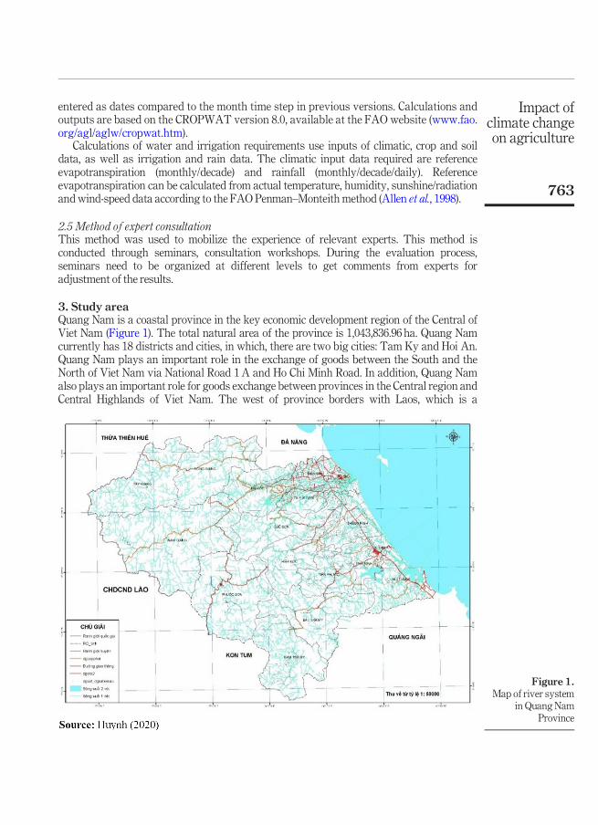
3. Study areaQuang Nam is a coastal province in the key economic development region of the Central ofViet Nam (Figure 1). The total natural area of the province is 1,043,836.96 ha. Quang Namcurrently has 18 districts and cities, in which, there are two big cities: Tam Ky and Hoi An.Quang Nam plays an important role in the exchange of goods between the South and theNorth of Viet Nam via National Road 1A and Ho Chi Minh Road. In addition, Quang Namalso plays an important role for goods exchange between provinces in the Central region andCentral Highlands of Viet Nam. The west of province borders with Laos, which is a
Figure 1.Map of river system
in Quang NamProvince
Impact ofclimate changeon agriculture
763

favorable condition for goods trade. Quang Nam also has a coastline of more than 125 km,an exclusive economic zone of more than 41,000 km2, which will be a condition for thedevelopment of the fisheries industry. Adjacent to Da Nang province, is considered a keyprovince for economic development in the central region and located in Chu Lai –Dung Quathigh-tech open economic zone. Thus, it can be said that the geographical position of QuangNam Province has contributed to giving the province quite a lot of advantages inexchanging and trading goods with domestic and foreign regions, creating favorableconditions for economic development of multidisciplinary and multi-sector, making theprovincial economymore andmore solid.
Agriculture in Quang Nam Province has been heavily affected by climate change inrecent years. Specifically, the crop patterns has changed markedly (from three crops to twocrops per annum), productivity, crop yield and water demand for crops are facing greatchallenges in the context of frequent and prolonged droughts. In addition, a number of newdiseases have appeared in livestock raising affecting activities of the local livestockindustry.
4. Climate change scenario for Quang Nam ProvinceThe climate change scenarios for Quang Nam Province were extracted from the climatechange scenarios developed for entire Viet Nam by Ministry of Natural Resources andEnvironment. In the development of climate change scenarios for Viet Nam, five Global andRegional climate models were used for calculations, namely, AGCM/MRI from JapaneseMeteorology Research Institute; PRECIS from Hadley Center, UK; CCAM from CSIRO,Australia; RegCM from ICTP, Italy; and clWRF from NCAR, USA. Each RCM is driven byGCMs from IPCC AR5. In total, there are 12 used members to update climate changescenario for Viet Nam. Details about the climate change scenarios for Viet Nam can be foundin Viet NamMinistry of Natural Resources and Environment (2016).
Under the impact of climate change, in the 21st century, the annual average temperatureand rainfall in Quang Nam Province have specific changes compared to that of the baselineperiod (1986-2005).
According to the representative concentration pathway (RCP)4.5 scenario, in the middle ofthe 21st century, the average annual temperature in Quang Nam Province increased to 1.4°Cand 1.8°C at the end of the 21st century (period 2080-2099). According to RCP8.5 scenario, in themiddle of 21st century, the average annual temperature in Quang Nam Province increased by1.3°C. By the end of the century, the annual average temperature increased by 3.2°C.
According to RCP4.5 scenario, in the middle of 21st century, the average annual rainfallin Quang Nam Province tends to increase by 24.9% compared to the baseline period. By theend of the 21st century, the average annual rainfall change will increase to 25.9%.According to RCP8.5 scenario, in the middle and the end of the 21st century, the averageannual rainfall tends to increase in Quang Nam Province with an increase of 25.9% and29.9% compared to the baseline period.
From Table 1, some observations on sea level rise scenario of Quang Nam Province canbe made as follows:
� According to RCP 4.5 scenario, in 2050, the sea level rise in Quang Nam will rangefrom 13.9–32.1 cm with an average value of 22.4 cm. By the end of the 21st centurythe values will be 32.9–76.0 cm with an average of 53.0 cm.
� According to RCP 8.5 scenario, in 2050, sea level rise in Quang Nam will be from17.1 to 35.0 cm with the average value of 25.2 cm. By the end of the 21st century thecorresponding values will be 50.0–102.2 cm with an average of 73.6 cm.
IJCCSM12,5
764
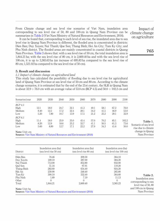
From Climate change and sea level rise scenarios of Viet Nam, inundation areacorresponding to sea level rise of 50, 80 and 100 cm in Quang Nam Province can besummarizes in Table 2 (Viet NamMinistry of Natural Resources and Environment, 2016).
It can be found that, corresponding to each level of sea rise, the inundated area due to sealevel rise in Quang Nam Province is different, the flooded area is concentrated in districts:Dien Ban; Duy Xuyen; Nui Thanh; Que Son; Thang Binh; Hoi An City; Tam Ky City; andPhu Ninh district. The flooded areas are mainly concentrated in coastal districts in QuangNam Province. Table 3 shows that: with a sea level rise of 50 cm, the total inundation area is1,844.21 ha; with the sea level rise of 80 cm, it is 2,669.40 ha and with the sea level rise of100 cm, it is up to 3,365.63 ha (an increase of 695.83 ha compared to the sea level rise of80 cm; 1,521.02 ha compared to the sea level rise of 50 cm).
5. Result and discussion5.1 Impact of climate change on agricultural landThis study has calculated the possibility of flooding due to sea level rise for agriculturalland of Quang Nam Province at sea level rise of 50 cm and 80 cm. According to the climatechange scenarios, it is estimated that by the end of the 21st century, the SLR in Quang Namis about 32.9� 76.0 cm with an average value of 53.0 cm (RCP 4.5) and 50.0 � 102.2 cm and
Table 1.Scenario of sea levelrise due to climatechange in Quang
Nam Province
Scenarios/year 2020 2030 2040 2050 2060 2070 2080 2090 2100
RCP 4.5High 12.1 18.0 24.7 32.1 41.3 49.1 58.1 67.2 76.0Medium 8.40 12.5 17.2 22.4 28.1 34.2 41.5 46.9 53.0Low 5.20 7.80 10.7 13.9 17.5 21.2 25.2 29.1 32.9
RCP 8.5High 11.4 18.0 25.9 35.0 45.4 57.0 70.2 85.1 102.2Medium 8.20 12.9 18.6 25.2 32.7 41.1 50.5 61.3 73.6Low 5.60 8.80 12.7 17.1 22.2 27.9 34.3 41.6 50.0
Note: Unit: cmSource: Viet NamMinistry of Natural Resources and Environment (2016)
Table 2.Inundation area
corresponding to sealevel rise of 50, 80
and 100 cm in QuangNam Province
DistrictInundation area (ha)(sea level rise 50 cm)
Inundation area (ha)(sea level rise 80 cm)
Inundation area (ha)(sea level rise 100 cm)
-Diện Bàn 76.46 209.30 364.10Duy Xuyên 189.10 287.00 384.20Núi Thành 712.00 852.80 932.00Quế Sơn 51.16 97.91 119.20Th�ang Bình 282.60 634.40 924.20Hội An 230.90 248.40 265.80Tam Kỳ 300.10 332.40 364.60Phú Ninh 1.89 7.19 11.13Other 0 0 0Total 1,844.21 2,669.40 3,365.23
Note: Unit: haSource: Viet NamMinistry of Natural Resources and Environment (2016)
Impact ofclimate changeon agriculture
765

73.6 cm (RCP 8.5), respectively (Viet Nam Ministry of Natural Resources and Environment,2016). By using the method of overlaying maps of innundation due to sea level riseannounced by the Viet NamMinistry of Natural Resources and Environment in combinationwith the Quang Nam Land Use map of 2015, the research team have calculated theagricultural land area that could be flooded corresponding to SLR and 50 cm and 80 cm.
FromTable 3, it can be found that:� When the sea level rises by 50 cm, the area of agricultural land likely to be flooded is
418.32 ha. In particular, ranked from high to low districts/cities with land areaslikely to be flooded as follows: Nui Thanh (144.56 ha); Tam Ky City (142.59 ha); DuyXuyen (39.12 ha); Thang Binh (35.29 ha); Dien Ban (27.30 ha); Que Son (19.56 ha); TPHoi An (8.98 ha); Phu Ninh (0.83 ha); Nong Son (0.09 ha).
� When the sea level rises 80 cm, the area of agricultural land likely to be flooded is637.07 ha. In particular, ranked from high to low districts/cities with land areaslikely to be flooded as follows: Nui Thanh (191.39 ha); Tam Ky City (157.13 ha); DuyXuyen (110.60 ha); Thang Binh (72.89 ha); Dien Ban (63.46 ha); Que Son (26.62 ha);Hoi An City (11.75 ha); Phu Ninh (2.88 ha); Nong Son (0.36 ha).
The agricultural land area likely to be inundated due to sea level rise accounts for arelatively small proportion of the total agricultural land area. However, to avoid losses toagricultural production in Quang Nam, it is still necessary to propose appropriate solutionsto suit the flooded area in the future.
5.2 Impact of climate change on rice yield in Quang Nam ProvinceCrop yields in general and rice yield in particular depend on climatic conditions greatly. Whenhaving favorable conditions, climate will be the basic factor for the process of growth anddevelopment. For sowing period of rice, the appropriate temperature is in the range of 20°C-35°C,the total number of sunny hours is over 700h. During tilling period, the most suitable temperatureis 25°C–32°C, temperatures lower than 16°C and higher than 38°C are not favorable. The floweringand seeding periods require themost suitable temperature is from 28°C–30°C (Thanh et al., 2016).
From the data series of rice yields from 1999-2018 in Quang Nam Province, there weremany fluctuations, especially in the winter–spring crop. Although the trend of riceproductivity is always increasing due to the application of intensive techniques. But in fact,
Table 3.Inundationagricultural landwith sea level rise of50 and 80 cm inQuang Nam Province
No. DistrictInundation area (ha)(sea level rise 50 cm)
Inundation area (ha)(sea level rise 50 cm)
1 Núi Thành 144.56 191.392 Tam Kỳ 142.59 157.133 Duy Xuyên 39.12 110.604 Th�ang Bình 35.29 72.895 -Diện Bàn 27.30 63.466 Quế Sơn 19.56 26.627 Hội An 8.98 11.758 Phú Ninh 0.83 2.889 Nông Sơn 0.09 0.36
Total 418.32 637.07
Note: Unit: haSource: Huynh (2020)
IJCCSM12,5
766
winter–spring rice productivity in many years decreased, caused by adverse weatherconditions (Statistical Yearbook of Quang Nam Province, 2000-2018).
To assess the impact of climate change on the rice yield in Quang Nam Province, theDSSAT model was applied to simulate future rice yield under different climate changescenarios. The climatic factors affecting the rice yield in Quang Nam Province were selectedas input data for the DSSATmodel include: annual average temperature; average maximumannual temperature; average minimum annual temperature and annual average rainfallunder baseline period and climate change scenarios.
To investigate the reliability and the accuracy of the calculated results obtained from theDSSAT model, the following widely used statistical measures were used: mean error (ME),mean absolute error (MAE), root mean square error (RMSE). From the data series of riceyields from 1999-2018, it is revealed that error in rice yield simulation of winter–spring cropis of 0.94 quintals/ha; summer–autumn crop of 0.54 quintals/ha. Thus, it can be confirmedthat the model was reliable to assess the impact of climate change on rice yield in QuangNam Province.
This study calculated yield changes for both winter–spring and summer–autumn ricecrops in the whole province, assuming no changes in varieties, caring methods, plantingdates, soil, irrigation regimes, but only the climate changes in temperature, rainfall,humidity, sunshine hours due to climate change. Specific results are as follows.
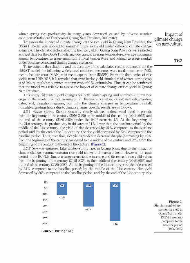
5.2.1 Winter–spring. Rice productivity clearly showed a downward trend in periodsfrom the beginning of the century (2016-2035) to the middle of the century (2046-2065) andthe end of the century (2080-2099) under the RCP scenario 4.5. At the beginning ofthe 21st century, the productivity in this area is 11% lower than the baseline period; by themiddle of the 21st century, the yield of rice decreased by 21% compared to the baselineperiod; and, by the end of the 21st century, the rice yield decreased by 33% compared to thebaseline period. Thus, over time, rice yields tended to decrease sharply (decreasing by 10%from the beginning of the century compared to the middle of the century and 22% from thebeginning of the century to the end of the century) (Figure 2).
5.2.2 Summer–autumn. Like winter–spring rice, in Quang Nam, due to the impact ofclimate change, summer–autumn rice yield shows a downward trend. However, for eachperiod of the RCP4.5 climate change scenario, the increase and decrease of rice yield variesfrom the beginning of the century (2016-2035), to the middle of the century (2046-2065) andthe end of the century (2080-2099). At the beginning of the 21st century, rice yield decreasedby 21% compared to the baseline period; by the middle of the 21st century, rice yielddecreased by 36% compared to the baseline period; and, by the end of the 21st century, rice
Figure 2.Simulation of winter–
spring rice yield inQuang Nam underRCP 4.5 scenariocompared to thebaseline period
(1986-2005)
Impact ofclimate changeon agriculture
767
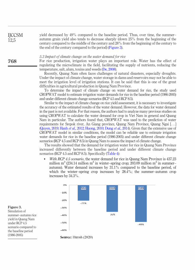
yield decreased by 49% compared to the baseline period. Thus, over time, the summer–autumn grain yield also tends to decrease sharply (down 25% from the beginning of thecentury compared to the middle of the century and 28% from the beginning of the century tothe end of the century compared to the period) (Figure 3).
5.3 Impact of climate change on the water demand for riceFor rice production, irrigation water plays an important role. Water has the effect ofregulating the microclimate in the field, facilitating the supply of nutrients, reducing thetemperature, salt, alum, toxins andweeds (De, 2008).
Recently, Quang Nam often faces challenges of natural disasters, especially droughts.Under the impact of climate change, water storage in dams and reservoirs may not be able tomeet the irrigation level of irrigation stations. It can be said that this is one of the greatdifficulties in agricultural production in Quang Nam Province.
To determine the impact of climate change on water demand for rice, the study usedCROPWATmodel to estimate irrigation water demands for rice in the baseline period (1986-2005)and under different climate change scenarios (RCP 4.5 andRCP 8.5).
Similar to the impact of climate change on rice yield assessment, it is necessary to investigatethe accuracy of the estimated results of the water demand. However, the data for water demandin the past is not available. For that reason, the authors had to analyzemany previous studies onusing CROPWAT to calculate the water demand for crop in Viet Nam in general and QuangNam in particular. The authors found that, CROPWAT was used to the prediction of waterrequirements for Srepok river, An Giang province, Quang Nam Province, Quang Ngai [. . .](Quyen, 2019; Hanh et al., 2012; Huong, 2010; Dung et al., 2014). Given that the extensive use ofCROPWAT model in similar conditions, the model can be reliable use to estimate irrigationwater demands for rice in the baseline period (1986-2005) and under different climate changescenarios (RCP 4.5 and RCP 8.5) in QuangNam to assess the impact of climate change.
The results showed that the demand for irrigation water for rice in Quang Nam Provinceincreased differently between the baseline period and under different climate changescenarios (RCP 4.5 and RCP 8.5). Specifically (Table 4):
� With RCP 4.5 scenario, the water demand for rice in Quang Nam Province is 437.23million m3 (234.14 million m3 in winter–spring crop; 203.09 million m3 in summer–autumn). Water demand increases by 31.1% compared to the baseline period, ofwhich the winter–spring crop increases by 28.4%; the summer–autumn cropincreases by 34.3%.
Figure 3.Simulation ofsummer–autumn riceyield in Quang Namunder RCP 4.5scenario compared tothe baseline period(1986-2005)
IJCCSM12,5
768

� With RCP 8.5 scenario, the water demand for rice in Quang Nam Province is 514.09million m3 (267.55 million m3 in winter–spring crop; 246.54 million m3 in summer–autumn crop). Water demand increases by 54.1% compared to the baseline period,of which the winter–spring crop increases by 46.7%; the summer–autumn cropincreases by 63.1%.
Thang Binh, Dien Ban, Dai Loc, Duy Xuyen, Que Son, Nui Thanh and Phu Ninh are thedistricts with greater irrigation demand than others. The different of water demand for ricein localities is closely dependent on local water supply capacity, rice cultivation area at thepresent time and in development plans.
6. ConclusionClimate change has been happening in Quang Nam Province. Simulation results from theDSSAT model show that, rice yield will decrease in both winter–spring and summer–autumn crops under climate change scenario RCP 4.5. By the end of the 21st century,winter–spring rice yield may decrease by 33%, while summer–autumn rice yield maydecrease by 49%. In this study, the authors only conducted research on the effects of climatechange on rice yield with the assumption that cultivation techniques, fertilizer regimes,intensive level, biotechnology are constant.
The evaluation results revealed the risk of climate change impacts on rice productivity inboth seasons (winter–spring and summer–autumn) in Quang Nam, contributing to helpQuang Nam Province have a more comprehensive view of agricultural activities in generaland rice production in particular in the context of climate change. With quantitativeestimates of the impacts of climate change, policymakers will be able to have more suitable
Table 4.Water demand forrice in 2046-2065
compared to baselineperiod in Quang Nam
Province
District/city
1986–2005 RCP4.5 RCP 8.5Winter–spring
Summer–autumn Total
Winter–spring
Summer–autumn Tổng
Winter–spring
Summer–autumn Total
Th�ang Bình 32,85 25,48 58,33 36,28 32,68 68,96 38,68 34,64 73,32-Diện Bàn 20,22 18,42 38,64 26,28 25,29 51,57 28,65 26,48 55,13-Dai Lộc 18,94 17,85 36,79 22,68 21,36 44,04 24,83 28,52 53,35Duy Xuyên 18,18 14,5 32,68 26,47 24,23 50,7 27,02 25,32 52,34Quế Sơn 16,3 12,52 28,82 22,13 14,04 36,17 23,16 18,62 41,78Núi Thành 13,34 12,98 26,32 18,65 16,82 35,47 20,27 18,12 38,39Phú Ninh 12,12 10,66 22,78 16,12 12,38 28,5 18,14 15,28 33,42Tiên Phước 10,57 6,44 17,01 14,06 8,26 22,32 16,27 9,34 25,61Nam Giang 2,46 7,94 10,4 6,28 8,82 15,1 9,15 10,23 19,38Hiệp -Dức 6,32 2,47 8,79 8,82 5,25 14,07 10,24 7,87 18,11Nông Sơn 7,23 1,46 8,69 8,43 3,66 12,09 9,62 8,17 17,79Bắc Trà My 4,56 3,39 7,95 6,12 5,23 11,35 8,13 8,25 16,38-Dông Giang 3,65 4,21 7,86 3,09 5,96 9,05 5,54 10,12 15,66Tam Kỳ 5,2 2,48 7,68 4,38 4,48 8,86 6,43 6,29 12,72Tây Giang 2,57 3,96 6,53 3,29 4,97 8,26 5,76 5,69 11,45Nam Trà My 2,63 3,18 5,81 3,68 4,25 7,93 5,13 5,98 11,11Phước Sơn 2,75 1,96 4,71 3,26 2,56 5,82 5,27 4,37 9,64Hội An 2,48 1,29 3,77 4,12 2,85 6,97 5,26 3,25 8,51Total 182,37 151,19 333,56 234,14 203,09 437,23 267,55 246,54 514,09
Note: Unit: 106 m3/yearSource: Huynh (2020)
Impact ofclimate changeon agriculture
769
adaptation options in the future, to minimize the potential damage to agriculture caused byclimate change.
Water demand for rice in Quang Nam Province is increasing. Under RCP 4.5 scenario,water demand increases by 31.1% compared to that of baseline period, of which the winter–spring crop increases by 28.4%; the summer–autumn crop increases by 34.3%. Under RCP8.5 scenario, water demand increases by 54.1% compared to the baseline period, of whichthe winter–spring crop increases by 46.7%; the summer–autumn crop increases by 63.1%.Districts such as Thang Binh, Dien Ban, Dai Loc, Duy Xuyen, Que Son, Nui Thanh and PhuNinh are the districts that have greater irrigation demand than other districts in both thebaseline period and the climate change scenarios (RCP 4.5 and RCP 8.5). Increased demandfor irrigation water is resulted from the area of the rice production and the expected droughtincrease in the future under the climate change scenario.
The area of agricultural land likely to be flooded in 2020 is 19,889.5 ha (accounting for12.2% of the provincial agricultural land area), in 2050 is 20.303.9 ha (accounting for 12.5%of the agricultural land area). The province’s industrial area is 21,402.4 ha in 2100(accounting for 15.6% of the province’s agricultural land area). The area of agricultural landlikely to be inundated increased by 28% (2020); 31% (2050); 63% (2100). The area ofinundation from 0–1m is the largest amongst various levels of flooding compared to 1999.The area of agricultural land likely to be inundated by sea level rise at 50 cm is 418.32 ha; at80 cm it is 637.07 ha. Such an inundated agricultural land area will be considered asignificant disadvantage for the agricultural sector in the future.
ReferencesAllen, R., Pereira, L.A., Raes, D. and Smith, M. (1998), “Crop evapotranspiration”, FAO Irrigation and
Drainage Paper No. 56, FAO, Rome.Dat, T.T., Truong, D.D. and Thu, V.T.H. (2019),The Impact of Climate Change on Viet Nam’s Economy,
National Economics University, Hanoi.
De, N.N. (2008), “Rice syllabus”, Can Tho University, Publishing house of National University of Ho ChiMinh City.
Dung, V.N., Huong, H.T.L. and Huong, C.T.T. (2014), “Assessment of the impact of climate change onwater demand for rice in Quang Ngai province”, Viet Nam Journal of Meteorology andHydrology, Vol. 3, pp. 43-48.
Giovanni, M. (2000), “CROPWAT.8 and CLIMWAT softwares”, Water Engineering Research Center(WERC).
Gordon, Y.T., Hoogenboom, G. and Thornton, P.K. (1998), “Understanding options for agriculturalproduction”, Kluwer Academic Publishers. ISBN 0-7923-4833-8.
Hanh, N.T.M., Ty, T.V., Minh, H.V.T., Tri, V.P.D. and Trung, N.H. (2012), “Application of the CropWatmodel to evaluate rice yield in the semi-dyke protected area in An Giang province in the contextof meteo-hydrological changes”,Viet Nam Science Journal, Vol. 24, pp. 187-197.
Hoa, D.T.T. (2013), “The impact of climate change on the rice industry in Lao Cai province andproposed response solutions”, Master of Science thesis, Ha Noi National University.
Huong, H.T.L. (2010), “Calculation of water balance in Quang Nam province”, Final report of provincialproject (in Vietnamese).
IPCC (2007), “Climate change 2007: impacts, adaptation and vulnerability, contribution of workingGroup II to the fourth assessment report of the intergovernmental panel on climate change”,Cambridge University Press, Cambridge, p. 976.
Lac, H. (2020), “Impact of climate change on agriculture”, Rural Environment Newspaper, Viet NamFarmers Association.
IJCCSM12,5
770
Lan, N.T. (2019), “Study the effects of climate change on Viet Nam’s agricultural economy”, HanoiUniversity of Natural Resources and Environment.
National Institute of agricultural extension management (NIAEM) (2012), “Climate change and itsimpact on agriculture”, National Institute of agricultural extension management.
Natural Resources and Environment (2018), “Agriculture responds to climate change”, Natural Resourcesand Environment Newspaper.
Nghia, T.D. (2017), “Support stocktaking and drafting of the agricultural component of Viet Nam’snational adaptation plan (NAP) progress”, Final report, Institute of Policy and Strategy forAgriculture and Rural Development.
Nhat, L.M. (2019), “Agriculture adapts to climate change”,Weekend Nhan dan newspaper.Prasad, R. and Rana, R. (2006), “A study on maximum temperature during March 2004 and its impact
on Rabi crops in Himachal Pradesh”, Journal of Agrometeorology, Vol. 8 No. 1, pp. 91-99.Quyen, N.T.N. (2019), “Prediction of water requirements for land use types in Srepok river basin in the
context of climate change”,Vietnam Journal of Agricultural Sciences, Vol. 17 No. 2, pp. 126-136.Samra, J.S., Singh, G. and Ramakrishna, Y.S. (2004), “Cold wave during 2002-2003 over North India and
its effect on crops”,The Hindu, dated 10th January, p. 6.Southern Institute of Agricultural Science and Technology (2013), “Climate change”.
Thanh, B., Tho, P.T.A. and Ngoc, L.A. (2016), “Testing results of rice varieties adapted to climaticconditions in Binh Thuy district, Can Tho city”, The XVIII proceeding of National ScienceConference on Meteorology, Hydrology, Environment and Climate Change. Viet Nam PublishingHouse of Natural Resources and Environment.
Thanh, D.V. and Viet, N.V. (2014), “Climate change impacts on agriculture and coping solutions”,Agricultural Publisher.
Viet NamMinistry of Natural Resources and Environment (2016), “Climate change and sea level rise scenariosfor Viet Nam”, Natural Resources –Environment PublishingHouse andViet NamMap, Hanoi.
Further readingQuang Nam Statistical Office (2000-2018), “Statistical Yearbook of Quang Nam province from 2000 to
2018”, Statistical Office Publish house, Quang Nam.
About the authorsHuong Thi Lan Huynh is currently working as a Senior Researcher at Viet Nam Institute of Meteorology,Hydrology and Climate change. She has been working in the fields of hydrology, hydraulic and climatechange. She has great experiences in issues of assessing the impact of climate change on water resourcesand assessing the impact of climate change on socio-economic aspects. She also has many studies relatedto natural disaster risk management, warning of extreme weather events. Huong Thi Lan Huynh is thecorresponding author and can be contacted at: [email protected]
Lieu Nguyen Thi is currently working at Climate Change Research Center under Viet NamInstitute of Meteorology, Hydrology and Climate Change. Her doctoral thesis focuses on assessing theimpact of climate change on agriculture. She is currently working in developing indicators to assessclimate change risks on natural resources.
Nguyen Dinh Hoang is currently working as a Researcher at Center for Hydrology and OceanResearch. He works extensively on hydrological and hydraulic models for flood forecasting and flashflood warning.
For instructions on how to order reprints of this article, please visit our website:www.emeraldgrouppublishing.com/licensing/reprints.htmOr contact us for further details: [email protected]
Impact ofclimate changeon agriculture
771


![LectureVI - konderak.eukonderak.eu/materialy/ics18_w6.pdf · Mental Modules, cont'd l Innateness, i.e. develop[ing]accordingto specific, endogenously determinedpatternsunderthe impactof](https://img.pdfslide.us/doc/110x75/5c7849c309d3f229578cb5fb/lecturevi-mental-modules-contd-l-innateness-ie-developingaccordingto.jpg)