Embed Size (px)
Citation preview
MERCYHIGH SCHOOL
GALILEOH.S.
MISSIONHIGH SCHOOL
RIORDANHIGH SCHOOL
LINCOLNHIGH SCHOOL
SAN FRANCISCONATL CEM
CA ACADEMYOF SCIENCES
SAINT PETERHIGH SCHOOL
ST MARYSHOSPITAL
SAN FRANCISCOCONSERVATIORY
MISSIONDOLORES
WASHINGTONHIGH SCHOOL
POLYTECHNICHIGH SCHOOL
ST FRANCIS HOSPITAL
MT ZIONHOSP
SAN FRANCISCOGENERAL HOSPITAL
SAN FRANCISCOCOLLEGE FORWOMEN
UNIV OF CASAN FRANCISCOMED CNTR
San Francisco
P R E S I D I O
Golden Gate Nat ional Recreat ion Area
Golden GateNational Recreation Area
Golden GateNational Recreation Area
13th District
12th District
3RD
ST
FULTON ST
STAT
E H
WY
1
CALIFORNIA ST
GEARY BLVD
MARKET ST
16TH ST
BUSH ST
GR
EAT
HW
Y
JUDAH ST
BALBOA ST
MIS
SIO
N S
T
OAK ST
BAY ST
FELL STHARRIS
ON ST
TURK ST
LAG
UN
A S
T
LINCOLN WAY
7TH ST
FILLM
OR
E S
T
TARAVAL ST
GO
UG
H S
T
20TH ST
4TH ST
SU
NS
ET
BLV
D
CA
ST
RO
ST
SILVER AVE
TAYLO
R S
T
28TH
AV
E
PACIFIC AVE
DO
LOR
ES
ST
PORTOLA
DR
NORIEGA ST
LIN
CO
LN B
LVD
DIV
ISA
DE
RO
ST
VICENTE ST
ARMY ST
OCEAN AVE
8TH ST
6TH ST
GU
ER
RE
RO
ST
17TH ST
25TH
AV
E
STATE HWY 35
BROADWAY
MA
SO
NIC
AV
E
GEARY ST
BRYANT S
T
7TH
AV
E
MONTEREY BLVD
S V
AN
NE
SS
AV
E
PO
TR
ER
O A
VE
10TH ST
5TH ST
MARINA BLVD
CLIPPER ST
TOW
NSEND ST
SA
NS
OM
E S
T
32ND
AV
E
EVANS AVEJERROLD AVE
DUBOCE AVE
COLUMBUS AVE
AR
GU
ELLO
BLV
D
SAN JOSE A
VE
30TH ST
EUCLID AVE
KEZAR DR
CORTLAND AVE
EMBAR
CAD
ERO N
ORTH
ST
CRESCENT AVE
TOLA
ND ST
SLOAT BLVD
THORNTON AVE
POINT LOBOS AVE
DIAM
ON
D H
EIGH
TS BLVD
ALEMANY
BLVD
18TH ST
DEWEY B
LVD
BERRY STGOLDEN GATE AVE
LOMBARD ST
OAKDALE AVE
TURK BLVD
OFARRELL ST1ST ST
BA
KE
R S
T
WALLER ST
BAT
TE
RY
ST
PR
ES
IDIO
BLV
D
BOSWORTH ST
PR
ES
IDIO
AV
E
LAGU
NA H
ON
DA
BLVD
ELK
ST
WOODSIDEAVE
SA
NTA
CLA
RA
AV
E
CERVANTES
BLVD
BUENA VISTA
AVE E
CH
UR
CH
ST
CLAY
TON
ST
KEIT
H ST
LILY S
T
P a c i f i c O c e a n
PRESIDIO
GOLF COURSE
LINCOLN PARKMUNI GC
FORT MILEY
GOLDEN GATEMUN GC
UNIV OFSAN FRANCISCO
SAN FRANCISCOART INSTITUTE
SAN FRANCISCO STATE UNIV
GOLDENGATE UNIV
NorthBeach
Marina
Chinatown
Mission
District
NoeValley
TwinPeaks
ForestKnolls
MidtownTerrace
MontereyHeights
WestPortal
ForestHill
Parkside
Lakeside
Stonestown
Sunset
Richmond
Seacliff
Haight-AshburyMission�
Bay
PotreroHill
GlenPark
BernalHeights
Castro
FinancialDistrict
TelegraphHill
GOLDEN GATE PARK
GOLDEN GATE NATL REC AREA
MCLAREN PARK
TWINPEAKSPARK
STERN REC CENTER
GLENCANYON PARK
BUENA VISTAPARK
PINE LAKE PARK
BALBOAPARK
MOUNT DAVIDSONPARK
CORONAHEIGHTS
FORT POINTNATL HIST SITE
Golden GateBridge
ALAMOSQUARE
BERNAL HEIGHTSPARK
LARSENPARK
LAFAYETTEPARK
ALTAPLAZAPARK
MOUNTAIN LAKEPARK
PARK SIDESQUARE
MCCOPPINPARK
HOLLYPARK
POTRERO HILLREC CENTER
MARITIME PLAZA
MISSIONDOLORESPARK
DUBOCEPARK
PIONEERPARK
MIDTOWNTERRACEREC CEN
DOUGLAS PLAYGROUND
GEORGE RMOSCONEREC CTR
GRAND VIEWPARK
ADAM ROGERSPARK
FRANKLINSQUARE
HAYWARDPLAYGROUND
JEFFERSONSQUARE
PORTOLAREC CENTER
ST MARYSPARK
JACKSONPLAYGROUND
HAMILTONREC CENTER
GOLDEN GATEHEIGHTS PARK
SUNSETREC CENTER
GARFIELDSQUARE
YOUNGBLOODPLAYGROUND
PRECITAPARK
EMBARCADEROPLAZA
MCKINLESQUARE
UPPER NOEREC CENTER
ELLA HILL HUTCHREC CENTER
SOUTH OFMARKETREC CEN
SOUTHPARK
ST MARYSSQUARE
HUNTINGTONPARK
RUSSIAN HILLPARK
POTRERO DEL SOLPARK
PORTSMOUTHSQUARE
WASHINGTONSQUARE
PARK
EUREKA VALLEYREC CENTER
BERNALREC CENTER
SOUTH OFMARKETREC CENTER
KOSHLNDPARK
NOEBEAVERPARK
SGT J MACAULAYPARK
JOSEPH CONRADPARK
CHINESEREC CENTER
1
1
80
280
280
101
101
101
Pacific Ave
Stanyan S
t
Broderick S
t
Fulton St
Twin Peaks Blvd
Det
roit
St
Bay S
hore Blvd
Turk Blvd
Malta Dr
Oshaughnessy Blvd
Circular Ave
Central A
ve
Clarendon Ave
Jackson St
Stillings Ave
Portola Dr
Divisadero S
t
15
06
01
07
08
26
02
10
17
04
19
11
28
20
14
18
05
21
25
22
161312
09
12
Yolo
SonomaNapa
Solano
San Joaquin
Marin
Alameda
Sacramento
Stanislaus
Contra Costa
Lake Placer
Santa Clara
SanMateo
Sutter
SanFrancisco
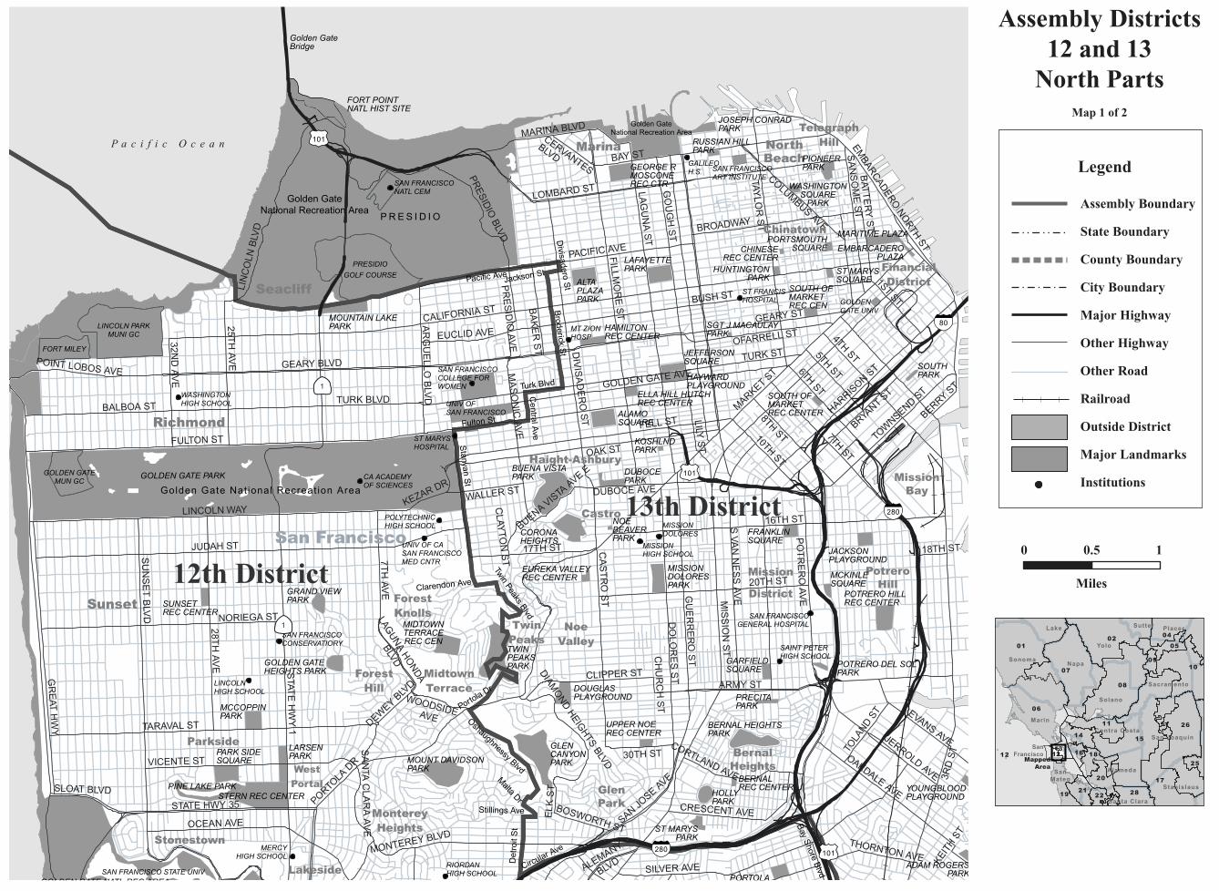
Assembly Districts12 and 13
North PartsMap 1 of 2
0 0.5 1
Miles
MappedArea
Legend
Assembly Boundary
State Boundary
County Boundary
City Boundary
Major Highway
Other Highway
Other Road
Railroad
Outside District
Major Landmarks
Institutions
MERCYHIGH SCHOOL
RIORDANHIGH SCHOOL
LINCOLN HIGH SCHOOL
SAINT PETERH.S.
SALEM CEM
ITALIANCEM
CHINESECEM
CHINESECEM
WOODLAWNCEM
OLIVETMEMORIALPARK
WESTMOORHIGH SCHOOL
BALBOAH.S.
CITY COLLEGEOF SAN FRANCISCO
SERBIANCEMETERY
GREENLAWNCEM
HOLY CROSSCEM
JEFFERSONH.S.
EL CAMINOH.S.
HOME OFPEACE CEM
CYPRESS LAWNMEMORIAL PARK
HILLS OF ETERNITYMEMORIAL PAR
San Francisco
Daly City
Brisbane
Colma
South San Francisco
Broadmoor
Pacifica
SAN BRUNO MTN STATE PARK
12th District
19th District
13th District
3R
D S
T
MIS
SIO
N S
T
HILLSIDE BLVD
OCEAN AVE
TARAVAL ST
SILVER AVE
BAY
SH
OR
E B
LVD
SK
YLIN
E D
R
PORTO
LA D
RVICENTE ST
ARMY ST
EVANS AVE
SU
NS
ET
BLV
D
VIE
NN
A S
T
SOUTHGATE AVE
FELTON ST
MONTEREY BLVD
MISSIO
N R
D
OAKDALE AVE
F ST
CLIPPER ST
SUNNYDALE AVE
JERROLD AVE
DO
LO
RE
S S
T
87TH ST
28T
H A
VE
JOHN M
UIR
DR
CA
ST
RO
ST
SA
INT
FR
AN
CIS
BLV
D
ING
ALL
S S
T
MANSELL ST
SA
N J
OS
E A
VE
30TH ST
BROTHERHOOD WAY
AIRPO
RT
BLVD
MIR
AM
AR
AV
E
DWIGHT ST
HICKEY BLVD
CRESCENT AVE
TOLA
ND
ST
PALOU AVE
SERRAMONTE BLVDSISTERS CITIES BLVD
GU
ER
RE
RO
ST
AVALON AVE
88TH ST
WINSTON DR
GARFIELD ST
EVERGREEN D
R
THORNTON AVE
GRAFTON AVE
BAY S
HO
RE B
LVD
HO
FFM
AN
ST
BOSWORTH ST
SCHOOL ST
DIA
MO
ND
HEIG
HTS
BLV
D
DEWEY B
LVD
MARKET ST
GU
TT
EN
BE
RG
ST
RA
MP
RA
MP
BAY
SH
OR
E B
LVD
RA
MP
PERSIA AVE
BELLEVUE AVE
UN
IVE
RS
ITY
ST
SA
N B
RU
NO
AV
E
PA
RK
PLA
ZA
DR
PAUL AVE
MILLER AVE
QU
INT
ST
KNOWLES AVE
WESTLAKE AVE
THERESA ST
WE
STG
ATE
DR
SA
NTA
CLA
RA
AV
E
GILMAN AVE
CR
OC
KE
R A
VE
LINCOLN AVE
ORANGE ST
MT VERNON AVE
KEIT
H S
T
MERCEDES WAY
SLOAT BLVD
SERRAMONTE
BLVD
MA
RK
ET
ST
S a n
F r a n c i s c o
B a y
THE OLYMPIC CCSAN FRANCISCO GC
SAN FRANCISCOSTATE UNIVHARDING
PARKMUN GC
GLENEAGLESINTERNATIONAL
GC CANDLESTICKPARK
Golden GateNational Recreation Area
SAN BRUNOMOUNTAIN ER
Golden GateN.R.A.
Bayview
MontereyHeights
WestPortal
Parkside
Lakeside
Stonestown
GlenPark
BernalHeights
S a n M a t e o C o u n t y
MCLAREN PARK
BAY VIEWPARKCROCKER
AMAZONPARK
CANDLESTICK PTSTATE REC AREA
BALBOAPARK
OCEAN VIEWREC CENTER
ADAM ROGERSPARK
STERN REC CENTER
ST MARYSPARK
HILLTOPPARK
BROOKSPARK
KELLOCHVELASCOPARK
GLEN CANYONPARK
MUSSEL ROCKPARK
SIGN HILLPARK
ORANGE MEMPARK
WESTLAKE PARK
GELLERTPARK
CANDLESTICK PTSTATE REC AREA
WESTMOORPARK
HILLSIDEPARK
MARCHBANKPARK
BAYSHOREPARK
BURI BURIPARK
BAYSHOREHEIGHTSPARK
FRANKFORTPARK
WESTLAKEPARK
CALLANPARK
PARADISE VALLEYPARK
GOLDEN GATENATL REC AREA
LONGVIEWPARK
GOLDEN GATENATL REC AREA
THORNTONSTATEBEACH
WESTBOROUGHPARK
TWINPEAKSPARK
STERN REC CENTER
GLENCANYON PARK
PINE LAKE PARK
MOUNT DAVIDSONPARK
BERNAL HEIGHTSPARK
LARSENPARKPARK SIDE
SQUARE
MCCOPPINPARK
HOLLYPARK
MIDTOWNTERRACEREC CENTER
DOUGLAS PLAYGROUND
PORTOLAREC CENTER
GOLDEN GATEHEIGHTS PARK
GARFIELDSQUARE
YOUNGBLOODPLAYGROUND
PRECITAPARK
UPPER NOEREC CENTER
POTRERO DEL SOLPARK
BERNALREC CENTER
1
1
1
35
35
82
82
280
280
280
101
101
Skyline B
lvd
Bay S
hore
Blvd
Junipero Serra B
lvd
Hillside Blvd
Eastmoor Ave
Malta D
r
Geneva Ave
Bry
ant S
t
Sulliva
n A
ve
Baldwin Ave
El C
amino R
eal
Detr
oit
St
Oshaughnessy Blvd
Twin Peaks Blvd
Circular Ave
Bay A
rea Rapid Transit R
R
Zita
Mnr
Edgew
ort
h A
ve
South
gate
Ave
Stillings Ave
Portola Dr
Junip
ero
Serra
Fw
y
Washington St
Amelia MTeglia Blvd
Carter St
Sou
th H
ill D
r
15
06
01
07
08
26
02
10
17
04
19
11
28
20
14
18
05
21
25
22
161312
09
12
Yolo
SonomaNapa
Solano
San Joaquin
Marin
Alameda
Sacramento
Stanislaus
Contra Costa
Lake Placer
Santa Clara
SanMateo
Sutter
SanFrancisco
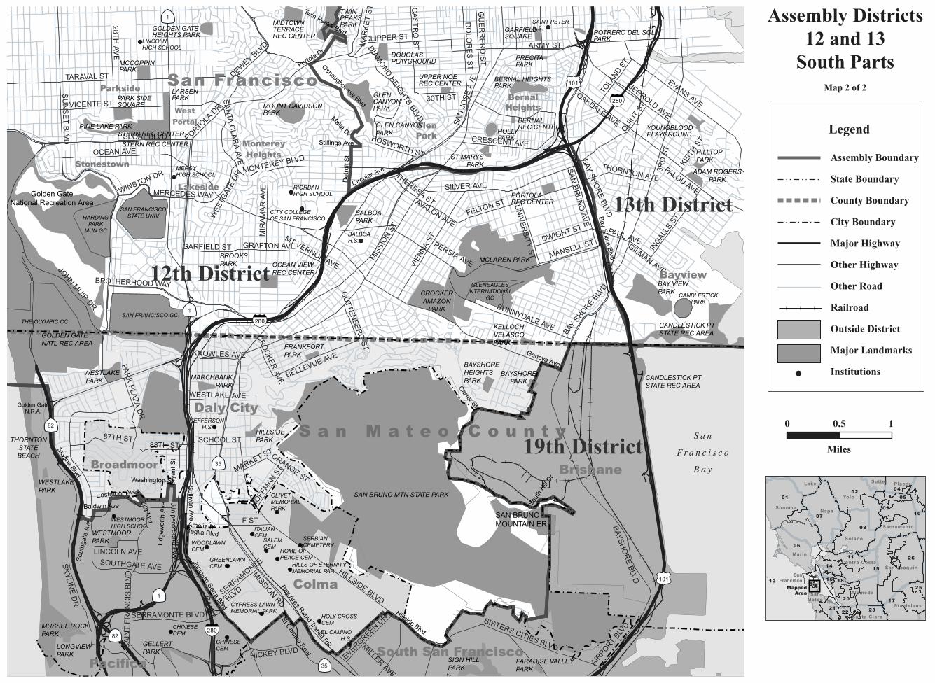
Assembly Districts12 and 13
South PartsMap 2 of 2
0 0.5 1
Miles
MappedArea
Legend
Assembly Boundary
State Boundary
County Boundary
City Boundary
Major Highway
Other Highway
Other Road
Railroad
Outside District
Major Landmarks
Institutions
C A L I F O R N I A A S S E M B LY D I S T R I C T S
Assembly Redistricting Plan (SB 802), September 13, 2001
The Honorable Robert M. Hertzberg, SpeakerState CapitolRoom 219Sacramento, CA 95814
The California State Assembly Rules CommitteeThe Honorable Dennis Cardoza, ChairP.O. Box 942849Sacramento, CA 94249-0001
The California State Assembly Committee on Elections, Reapportionment, and Constitutional AmendmentsThe Honorable John Longville, ChairP.O. Box 942849Sacramento, CA 94249-0001
Produced at California State University NorthridgeDr. Jolene Koester, President
Eugene Turner, Project DirectorDepartment of Geography18111 Nordhoff St.Northridge, CA 91330
with
Rubyjane Domingo, Pat Jolley, Meredith Leonard
2001
About the Maps
These maps present specific informationabout the features comprising the borders of theAssembly Districts of California that were cre-ated after the 2000 Census. Each of the 80 dis-tricts are represented by one to ten maps withthe number depending on the size of the districtand the complexity of the features followed bythe boundary. In general, the boundaries followcounty lines, city limit lines, and roads, butoccasionally canals, streams, and small roadsare followed.
The Assembly boundary data were creat-ed in digital form from Census 2000 TIGERfiles for California by Pactech Incorporated ofPasadena, CA. The boundary files were releasedin two forms, as a file of district polygons andas a file of line segments used to create thepolygons. Where these line segments were iden-tified, those identifiers were used to label themap boundaries. In addition, place boundarieswere created from the TIGER files.
Other map information such as roads,railroads, coastlines, and landmarks wereobtained from Geographic Data Technologies.Dynamap 2000 files (v10.1). Government landownership information such as national forestboundaries was obtained from a governmentland ownership layer prepared by the CaliforniaTeale Data Center.
Maps were prepared from the digitalfiles using Arcmap 8.1 software fromEnvironmental Systems Research Incorporated.An Albers equal area projection was used forthe maps with a central meridian of 120 degreeswest longitude and standard parallels of 30 and40 degrees of latitude. Coordinates are based onNAD83.