Embed Size (px)
Citation preview

March 2014
Client: Mrs Rebecca Pickford
Issue No: 1
OA Job No: 5875
NGR: SP 53629 26215
Ashgrove FarmArdleyOxfordshire
Historic Building Recording and Investigation
Histo
ric Build
ing Re
co
rding
and
Investig
atio
n


Client Name: Mrs Rebecca Pickford
Document Title: Ashgrove Farm, Ardley, Oxfordshire
Document Type: Historic Building Recording and Investigation
Issue Number: 1
Grid Reference: SP5362926215
OA Job Number: 5875
Site Code: ARAF 14
Invoice Code: ARAFBS
Prepared by: Angela Warner
Position: Buildings Archaeologist
Checked by: Jonathan Gill
Position: Project Manager (Historic Buildings)
Approved by: Julian Munby Signed..............................................
Position: Head of Historic Buildings
Date: March 2014
Document File Location: C:\Documents and Settings\markus.dylewski\My Documents\Downloads\Ashgrove Farm Ardley report.odt
Illustrated by: Markus Dylewski Disclaimer:
This document has been prepared for the titled project or named part thereof and should not be relied upon or used for any otherproject without an independent check being carried out as to its suitability and prior written authority of Oxford Archaeology beingobtained. Oxford Archaeology accepts no responsibility or liability for the consequences of this document being used for a purposeother than the purposes for which it was commissioned. Any person/party using or relying on the document for such other purposesagrees, and will by such use or reliance be taken to confirm their agreement to indemnify Oxford Archaeology for all loss or damageresulting therefrom. Oxford Archaeology accepts no responsibility or liability for this document to any party other than theperson/party by whom it was commissioned.
© Oxford Archaeology Ltd 2014
Oxford Archaeology
Janus House
Osney Mead
Oxford OX2 0ES
t: (0044) 01865 263800 e: [email protected]
f: (0044) 01865 793496 w: www.thehumanjourney.net
Oxford Archaeological Unit Limited is a Registered Charity No: 285627
© Oxford Archaeology (i) March 2014

© Oxford Archaeology (ii) March 2014

Ashgrove Farm, Ardley, Oxfordshire
Historic Building Recording and Investigation
Table of Contents
Summary..............................................................................................................................................1
1 Introduction......................................................................................................................................2
1.1 Background........................................................................................................................2
1.2 Aims and objectives..........................................................................................................2
1.3 Methodology.....................................................................................................................2
2 Historical background.....................................................................................................................2
2.1 Ardley................................................................................................................................2
2.2 Ashgrove Farm..................................................................................................................3
3 General Description.........................................................................................................................4
3.1 Ashgrove Farm..................................................................................................................4
4 Open barn 'Barn 1'..........................................................................................................................5
4.1 General description...........................................................................................................5
5 Workshop Building 'Barn 2'...........................................................................................................5
5.1 External description..........................................................................................................5
5.2 Internal description...........................................................................................................6
6 Threshing Barn 'Barn 3'.................................................................................................................9
6.1 External description..........................................................................................................9
6.2 Internal description.........................................................................................................10
7 Stables 'Barn 4 & Barn 5'.............................................................................................................10
7.1 External and General description...................................................................................10
7.2 Internal description.........................................................................................................10
8 Conclusion......................................................................................................................................13
Appendix A. Bibliography...............................................................................................................14
Appendix B. Listed Building Description......................................................................................15
Appendix C. Excerpts from the Sale Catalogue Description......................................................16
© Oxford Archaeology (iii) March 2014

List of Figures
Figure 1: Site location
Figure 2: Davis Map, 1797
Figure 3: Tithe Map, 1839
Figure 4: Plan associated with the Sale Catalogue, 1894
Figure 5: Barn Numbering Convention
Figure 6: Barn 2, ground floor
Figure 7: Barn 2, first floor
Figure 8: Barn 3
Figure 9: Barns 4 & 5
List of Plates
Plate 1: Main farmhouse building; south elevation
Plate 2: Farmhouse building; detail of first floor addition and pitching door; north elevation
Plate 3: Stable or loosebox to the west of the threshing barn; south elevation
Plate 4: Stable or loosebox to the west of the threshing barn; north elevation
Plate 5: Black barn and modern building to the far eastern end of the site; looking east
Plate 6: Modern building to the far eastern end of the site; north elevation
Plate 7: Silo bases and the bases of removed modern buildings; looking west
Plate 8: Barn 1; north elevation
Plate 9: Barn 1 rear wall; view from cowsheds looking north
Plate 10: Barn 2; north and west elevations
Plate 11: Barn 2; south elevation
Plate 12: Barn 2; west elevation
Plate 13: Barn 2; east elevation
Plate 14: Barn 2; east end of north elevation
Plate 15: Barn 2; central passageway looking east
Plate 16: Barn 2; dividing wall between Shepherd's Granary and void over passageway
Plate 17: Barn 2; Roof truss in Modern Carpenter's Workshop
Plate 18: Barn 2; Roof truss in the General Workshop
Plate 19: Barn 2; fireplace in the Warming Room
Plate 20: Barn 2; Warming Room window
Plate 21: Barn 2; Farrier's Workshop
Plate 22: Barn 2; General Workshop showing blocking of large opening
Plate 23: Barn 2; Oil Drum Store
Plate 24: Barn 2; Modern Carpenter's Shop, ground floor looking east
Plate 25: Barn 2; Modern Carpenter's Shop, ground floor looking west
© Oxford Archaeology (iv) March 2014
Plate 26: Barn 2; Modern Carpenter's Shop, first floor looking east
Plate 27: Barn 2; Modern Carpenter's Shop, first floor looking west
Plate 28: Barn 2; Mill House steps and landing looking west
Plate 29: Barn 2; drive machinery between the Mill House and Passageway
Plate 30: Barn 3; south elevation
Plate 31: Barn 3; north elevation
Plate 32: Barn 3; east elevation
Plate 33: Barn 3; blocked doorway in the south wall
Plate 34: Barn 3; opening for modern machinery in the north wall
Plate 35: Barn 3; Pigsties to the south of the threshing barn looking west
Plate 36: Barn 3; Pigsties and associated building looking south west
Plate 37: Barn 3; truss
Plate 38: Barn 3; stopped chamfered tie-beam
Plate 39: Barn 3; threshing floor and storage bay floor looking north east
Plate 40: Barn 5; south elevation looking north east
Plate 41: Barn 5; east and north elevations looking south west
Plate 42: Barns 4 & 5; join between the block and the farmhouse on the north elevation
Plate 43: Barns 4 & 5; join between the block and the farmhouse on the south elevation
Plate 44: Barn 5; truss
Plate 45: Barn 5; manger and hayrack along south wall in the Easternmost Stable/Loosebox
Plate 46: Barn 5; Tackroom
Plate 47: Barn 5; Partition dividing the Easternmost and Central Stable/Loosebox
Plate 48: Barn 5; Central Stable/Loosebox showing makeshift stalls
Plate 49: Barn 5; Central Stable/Loosebox floor detail
Plate 50: Barn 4 & 5; Partition of Store at west end of Barn 5 and Large Store of Barn 4
Plate 51: Barn 4; General Shot looking west
© Oxford Archaeology (v) March 2014


Ashgrove Farm, Oxfordshire Historic Building Recording and Investigation
Ashgrove Farm, Ardley, OxfordshireSummary
Oxford Archaeology was commissioned to record Ashgrove Farm as it stood in March2014, ahead of the proposed conversion of several of the agricultural buildings todomestic use, including the demolition of some of the twentieth-century agriculturalbuildings.
Ashgrove Farm is a fairly small farm, set roughly around a farmyard. The currentrange of buildings date from the early-mid eighteenth century to the mid twentiethcentury and briefly consist of limestone threshing barn, pigsties, stables andlooseboxes, modern open barns and a brick built early-mid Victorian farmhouse.
The early-mid eighteenth century threshing barn, listed as Grade II in 1988, lacks itsoriginal roof covering and barn doors, but retains the roof trusses and brick threshingfloor.
© Oxford Archaeology Page 1 of 19 March 2014

Ashgrove Farm, Oxfordshire Historic Building Recording and Investigation
1 INTRODUCTION
1.1 Background1.1.1 In March 2014 Oxford Archaeology (OA) was commissioned by Mrs Rebecca Pickford
to undertake a programme of historic building investigation and recording on a number ofagricultural structures at Ashgrove Farm, Ardley, Oxfordshire.
1.1.2 The buildings included in the study, and those associated structures not included in theplanning application, are currently in use as agricultural buildings, workshops andstorerooms. It is intended to convert and extend five of the buildings for use as dwellings,with demolition of several of the 20th-century buildings.
1.1.3 The threshing barn, referred to in the architectural plans as 'Barn 3', is Grade II Listed.
1.2 Aims and objectives1.2.1 The principal aims of the current work have been:
● To help meet the requirements of Condition 19 of the planning permission;● to investigate and record for posterity the areas of the building which will be
impacted by the proposed works;● to enhance understanding of the nature of the structures; ● to make the record publicly accessible through a report (a public document) and a
project archive deposited with a public institution.
1.3 Methodology1.3.1 The recording covered five buildings at Ashgrove Farm: the Grade II Listed barn, the
open barn, a stable block latterly considered as two 'barns' and a multi-purpose buildingcurrently in use as workshops and storage.
1.3.2 Architect's drawings supporting the planning application were made available to OA.These drawings were used as a basis for the archaeological recording; locations offeatures being verified and the addition of further annotations for the purpose of phasing.
1.3.3 The work also included photographic and descriptive recording of each of the buildingsto explain or interpret them in terms of their construction, history, structural form,development and use.
1.3.4 It should be noted that the convention of using the building alignment in the architect'sdrawings to assume a 'site north' (approximately north-north east) has been followed herein all descriptions.
2 HISTORICAL BACKGROUND
2.1 Ardley2.1.1 Ardley village belongs to the Civil Parish of Ardley with Fewcott, close to the border
with Northamptonshire, and lies roughly between the towns of Bicester and Brackley. Itis adjacent to the turnpike road between Oxford and Northampton. The church lies to the
© Oxford Archaeology Page 2 of 19 March 2014

Ashgrove Farm, Oxfordshire Historic Building Recording and Investigation
far south east of the village centre with the earthworks of a reputed anarchy castleadjacent.
2.1.2 Ashgrove Farm is located approximately one mile south of the main settlement; alimestone quarry lies immediately to the east of the farm (Fig 1).
2.1.3 The area sits directly onto the Jurassic white limestone formation, with no superficialdeposits recorded by the British Geological Survey. A palaeochannel immediately to thewest of the site records sand and gravel-containing alluvial deposits.
2.2 Ashgrove Farm2.2.1 The Davis Map of 1797 (Fig 2) shows two parallel ranges of buildings running
approximately north east-south west. It can only be assumed that this may have beenintended to only represent the presence of buildings on the site, as this does not reflectthe layout or alignment of the buildings likely to have been present in 1797.
2.2.2 Two maps available online: the Ordnance Survey Banbury Union Map,1803 and theBritish Library's William Stanley's Map of Bicester, 1815 both refer to the farm shown inthis location on the respective maps as 'Simcox Farm', with 'Ashgrove Farm' nearer toArdley in the case of the 1803 map, however, no documents available at the OxfordshireRecord Office refer to this, nor does the Sale Catalogue of 1894; coupled with the layoutof the buildings not appearing to correlate with the location of the threshing barn, it hasnot been taken into account for this study. Further research may be considered to clarifythis information.
2.2.3 The Tithe Map of 1839 (Fig 3) is the earliest map available which shows the farm indetail; the threshing barn is clearly shown with the adjoining later stable or looseboxbuilding to its western end. It can also be noted that the pigsties at the south of thethreshing barn are not yet built. 'Barn 2', that which now contains the workshops, is alsonotable by its absence.
2.2.4 Two model cottages were built to the north of the entrance from the road in 1870, but arenot included in this study.
2.2.5 The Duke of Marlborough sold the farm in 1894, and it was sold within a couple ofdecades to the Pickford family who still own it.
2.2.6 The map associated with the Sale Catalogue of 1894 (Fig 4) shows clearly the addition of'Barn 2' and also the extension of the range of farmhouse buildings to create the stablesnow referred to as 'Barn 4' and 'Barn 5'. It also shows that the farmhouse has undergonesome alteration in this period, namely the addition of the building which forms the mainfarmhouse and the smaller outhouses.
2.2.7 The Ordnance Survey maps indicate few changes until the mid twentieth century with theconstruction of the modern agricultural buildings which are now present or have beenrecently demolished.
© Oxford Archaeology Page 3 of 19 March 2014
Ashgrove Farm, Oxfordshire Historic Building Recording and Investigation
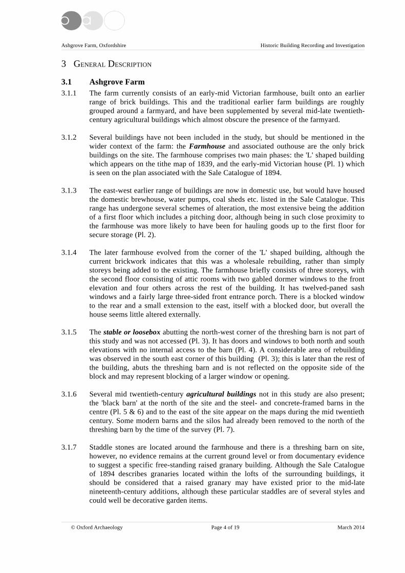
3 GENERAL DESCRIPTION
3.1 Ashgrove Farm3.1.1 The farm currently consists of an early-mid Victorian farmhouse, built onto an earlier
range of brick buildings. This and the traditional earlier farm buildings are roughlygrouped around a farmyard, and have been supplemented by several mid-late twentieth-century agricultural buildings which almost obscure the presence of the farmyard.
3.1.2 Several buildings have not been included in the study, but should be mentioned in thewider context of the farm: the Farmhouse and associated outhouse are the only brickbuildings on the site. The farmhouse comprises two main phases: the 'L' shaped buildingwhich appears on the tithe map of 1839, and the early-mid Victorian house (Pl. 1) whichis seen on the plan associated with the Sale Catalogue of 1894.
3.1.3 The east-west earlier range of buildings are now in domestic use, but would have housedthe domestic brewhouse, water pumps, coal sheds etc. listed in the Sale Catalogue. Thisrange has undergone several schemes of alteration, the most extensive being the additionof a first floor which includes a pitching door, although being in such close proximity tothe farmhouse was more likely to have been for hauling goods up to the first floor forsecure storage (Pl. 2).
3.1.4 The later farmhouse evolved from the corner of the 'L' shaped building, although thecurrent brickwork indicates that this was a wholesale rebuilding, rather than simplystoreys being added to the existing. The farmhouse briefly consists of three storeys, withthe second floor consisting of attic rooms with two gabled dormer windows to the frontelevation and four others across the rest of the building. It has twelved-paned sashwindows and a fairly large three-sided front entrance porch. There is a blocked windowto the rear and a small extension to the east, itself with a blocked door, but overall thehouse seems little altered externally.
3.1.5 The stable or loosebox abutting the north-west corner of the threshing barn is not part ofthis study and was not accessed (Pl. 3). It has doors and windows to both north and southelevations with no internal access to the barn (Pl. 4). A considerable area of rebuildingwas observed in the south east corner of this building (Pl. 3); this is later than the rest ofthe building, abuts the threshing barn and is not reflected on the opposite side of theblock and may represent blocking of a larger window or opening.
3.1.6 Several mid twentieth-century agricultural buildings not in this study are also present;the 'black barn' at the north of the site and the steel- and concrete-framed barns in thecentre (Pl. 5 & 6) and to the east of the site appear on the maps during the mid twentiethcentury. Some modern barns and the silos had already been removed to the north of thethreshing barn by the time of the survey (Pl. 7).
3.1.7 Staddle stones are located around the farmhouse and there is a threshing barn on site,however, no evidence remains at the current ground level or from documentary evidenceto suggest a specific free-standing raised granary building. Although the Sale Catalogueof 1894 describes granaries located within the lofts of the surrounding buildings, itshould be considered that a raised granary may have existed prior to the mid-latenineteenth-century additions, although these particular staddles are of several styles andcould well be decorative garden items.
© Oxford Archaeology Page 4 of 19 March 2014

Ashgrove Farm, Oxfordshire Historic Building Recording and Investigation
3.1.8 The 'Barn' numbers as follows use the conventions in the architect's drawings of theproposed scheme (Fig 5).
4 OPEN BARN 'BARN 1'
4.1 General description4.1.1 The most modern of the structures in the scope of the study, the Open Barn is a typical
mid-late twentieth-century steel-framed structure aligned approximately east-west. Being6 bays in size, it is open to the front (north elevation) and currently used to store plantand machinery (Pl. 8).
4.1.2 The roof is clad with corrugated sheeting, probably of asbestos cement, with occasionalclear plastic corrugated sheets to form roof-lights. The floor of the barn appears to consistof rammed earth.
4.1.3 The structure is supported at the rear (its south wall) by the coursed limestone wall whichforms the dividing wall to the adjacent modern open cow barn to the south (Pl. 9).
4.1.4 The western end of the barn is formed by the gable of Barn 2, which is discussed later.
4.1.5 The east end of the barn consists of concrete blocks to approximately 1.5m with theremainder of the frame clad with corrugated sheeting to the apex.
4.1.6 A building is shown on the maps of 1839 and 1894 in this location and it should beconsidered that the limestone wall at the rear of the structure is the remainder of thisbuilding.
5 WORKSHOP BUILDING 'BARN 2'
5.1 External description5.1.1 Barn 2 (Figs 6&7) is the most grand of the agricultural buildings (Pl. 10). Appearing at a
point between the Tithe Map of 1839 and the Sale Catalogue plan of 1894, the walls areof irregular coursed limestone with rusticated limestone quoins with matching dressingsto the original external doors, windows and openings.
5.1.2 The original front elevation to the south is now virtually obscured by the modern cowsheds and the doors and first floor windows have been blocked at different times (Pl.11).
5.1.3 The north elevation originally contained two open-fronted workshops, one of which isnow blocked, and a warming room accessed directly from this side of the building. Theinteriors of which are discussed in the next section.
5.1.4 The west elevation (Pl. 12) features a modern externally mounted rolling steel door to alarge opening below a timber lintel with a simple stone arch above: as the infill below thearch to the top of the lintel is consistent with the surrounding stonework, it can beassumed that the arch is for weight distribution and therefore structural rather than aformer arched opening. The window to the left of the door, to the warming room, hasbeen boarded over, but the frame survives beneath. To the right of the door is a pitchingdoor at second storey level, although this has been replaced with a modern glazed door.
© Oxford Archaeology Page 5 of 19 March 2014

Ashgrove Farm, Oxfordshire Historic Building Recording and Investigation
5.1.5 The east elevation is partially obscured by the cow sheds, but appears to lack windowsand doors other than the large opening, originally as per the opposite end of the building,but now partially blocked with modern aerated concrete blocks and a secondary timberlintel. The new access door and frame are of modern steel. This work was carried outwithin the previous decade by the current staff1. As per the opposite elevation, the archabove the original opening appears to be structural rather than to create extra height (Pl.13).
5.1.6 The 'catslide' of the roof is due to the northernmost rooms consisting of a side aisle,contemporary with the rest of the building. The roof is now covered with new corrugatedmetal sheeting, but was originally slate, as noted in the Sale Catalogue description; oneof the original slates survives as a tally board in the former farrier's shop2.
5.1.7 The windows are a metre wide, splayed to the internal face, and were originally wooden-framed horizontally sliding sashes, with each sash having eight panes. Many windowshave been replaced with frames reclaimed from elsewhere, detailed particularly in thesection on the general workshop. Many of the replacements are of Crittall-style metalframed windows; these were common in the mid twentieth century and may be indicativeof a scheme of replacement around the time when the farm was expanded with theaddition of the modern agricultural buildings (Pl. 14).
5.2 Internal description5.2.1 Internally, the building consists of a variety of workshops accessed internally and/or
externally, surrounding a central passageway. The passageway is floored with rammedearth to the easternmost end, where it is open to the roof, and with modern concrete to thewesternmost end, where the joists for the floor of the workshop above form the ceiling.This end also contains a modern inspection pit covered with timber, built within the lastdecade3 (Pl. 15).
5.2.2 As previously discussed, the rooms to the north side of the building are constructed as anaisle to the rest of the building and are divided up into a total of six bays and are allsingle storey, open to the rafters, with the passageway and southernmost rooms dividedinto eight bays and being of two storeys.
5.2.3 The internal walls are of coursed limestone rubble and are uniformly 46 cm thick.
5.2.4 The two two-storey compartments to the south side of the building are divided just to theeast of the second truss from the east. The wall is constructed from roughly coursedlimestone rubble to a height of approximately 2m with brick, in a Flemish garden wallbond, to the remaining height to the apex (Pl. 16). All of this wall apart from the eastelevation above the passageway is whitewashed or emulsioned. It is clear from the butt-joint to the limestone walls that the partition wall is later, although it was present by 1894as the two compartments are clearly described.
5.2.5 The roof trusses are of king post construction with through purlins of timber poles. Themortice and tenon joints to the braces are occasionally visible where timbers have been
1 After personal communication with staff on site.2 Ibid.3 Ibid.
© Oxford Archaeology Page 6 of 19 March 2014

Ashgrove Farm, Oxfordshire Historic Building Recording and Investigation
removed, with the tie-beam and king post being bolted together (Pl. 17). The rafters andridge piece appear to be original, however, they are only visible in the Shepherd'sGranary where there is no light source. Any original battens have been removed.
5.2.6 The roof timbers to the aisled rooms are simply braced between the rafter and the joint ofthe beam and wall (Pl. 18).
5.2.7 The roof timbers are of machine-sawn timber, and do not show signs of reuse other thanalteration in-situ according to the changes in use of the rooms.
5.2.8 No carpenter's marks or other markings were noted in any of the timbers, however, somerooms lacked a light source and so inspection by torchlight was carried out as far asfeasible.
5.2.9 Accessed only from the external door at the west end of the north elevation, the WarmingRoom and tool store is possibly the room described in the Sale Catalogue as the 'CoalHouse and Implement Shed', the later brick fireplace marks an alteration of use, probablyas the warming room for workers or customers of the farrier next door, requiring noaccess to the main building (Pl. 19).
5.2.10 The one-bay warming room retains a very small timber mezzanine and shelves which arestill used for tool storage. The room is accessed by a later ledged door, but retains awindow, boarded externally (Pl. 20). Probably an early replacement due to the extratimber packing around it, the window currently consists of one fixed light and oneopening casement, with 12 rectangular leaded panes in each, although a central glazingbar in the fixed light may indicate an earlier glazing scheme. Internally, the window issplayed and below a timber lintel.
5.2.11 The one-bay Farrier's Workshop is open to the north elevation, although with a run ofshort vertical planks below the eaves. All that remains of any fixtures or fittings is thebrick flue, even the limestone flag floor has since been removed (Pl. 21).
5.2.12 The current General Workshop was formerly the Blacksmith's Shop described in the SaleCatalogue. Originally, this three-bay room was open to the north elevation, as per theFarrier's Workshop, however, it was blocked approximately thirty years ago by thecurrent staff to form a workshop accessible only from the central passageway4 (Pl. 22).The large opening was below a long timber lintel and has been blocked with brickinternally with an outer skin of coursed limestone similar to the external walls. The twowindows at either end of the wall of the room are original, and the two windows in theblocked area are reclaimed Crittal-style, metal framed, eight paned windows with twoopening casements of three and one pane respectively, and match the oil drum storewindow to the east end of the elevation.
5.2.13 The floor in the General Workshop has since been laid in modern concrete and variousbenches and fittings, including a home-made wood burning stove have been added. Thereare no signs of surviving features of the Blacksmith's Shop.
5.2.14 The current Oil Drum Store is by process of elimination, the Carpenter's Workshopmentioned in the Sale Catalogue. A small, one bay room with a simple ledged doorleading to the room from the main passageway, the floor is of rammed earth and the
4 Ibid.
© Oxford Archaeology Page 7 of 19 March 2014

Ashgrove Farm, Oxfordshire Historic Building Recording and Investigation
window is a later replacement which matches the reclaimed windows used in the GeneralWorkshop, as described previously (Pl. 23).
5.2.15 To the south of the passageway, the building is split into two two-storey compartments:the westernmost of six bays and the easternmost of two bays with a brick wall dividingthe compartments.
5.2.16 Modern Carpenter's Workshop. The presence of the pitching door in the upper floor,indicates the six-bay, two-storey compartment is probably the 'chaff house with straw loftover' mentioned in the Sale Catalogue, however, little survives of the original features orlayout of these rooms with the exception of the former landing platform at the east end ofthe ground floor, and this has been re-floored with modern board (Pl. 24). The currentdog leg staircase and opening is modern, built within the last couple of decades, and bothstoreys have been re-floored in chipboard.
5.2.17 The ground floor of the compartment has a false floor of chip board, presumably overjoists laid onto the original earth floor. The aforementioned platform at the east end of theroom spans the width of the room, between the north and south walls, and extends 1.8mout from the east wall. It has been re-covered in modern chipboard and only one supportremains, exposing the mortices for the missing supports.
5.2.18 The original external doorway has been blocked using concrete blocks to the internalface, but limestone to the external face.
5.2.19 The only remaining doorway, to the passageway, is a simple ledged door with a circularrecessed latch.
5.2.20 The modern staircase, as described, leads to the upper storey (Pl. 25).
5.2.21 The upper storey of the compartment consists of coursed limestone rubble walls to thethree external walls, with brick to the partition wall to the east. The walls have beenroughly plastered up to a height of c 1.2m, with the exception of the south eastern cornerbetween the blocked window and blocked door, indicating the location of the formerstairway, as the landing is immediately below in the ground floor room. This was eitherto provide protection to the straw originally stored here, or to protect the walls from theactions of the later function of the room (Pl. 26).
5.2.22 The upper storey contains a blocked window in the south wall. From the externalelevation and the materials used, it is apparent that this was blocked when the cow shedswere constructed in the third quarter of the 20th century.
5.2.23 The west wall contains a pitching door, now with a modern glazed door (Pl. 27).
5.2.24 The two-bay easternmost compartment is the Mill House, with the room above describedin the Sale Catalogue as the Shepherd's Granary.
5.2.25 The original steps survive, and the timber landing at the western end of the room alsosupports a small hopper and mill wheel above and the associated machinery below (Pl.28), still connected to the drive belt and wheels in the passageway adjacent (Pl. 29).
© Oxford Archaeology Page 8 of 19 March 2014

Ashgrove Farm, Oxfordshire Historic Building Recording and Investigation
5.2.26 Both storeys contain blocked doors and windows to the south elevation as per theprevious set of rooms. The upper storey also contains a former pitching door to the eastelevation; partially blocked using limestone rubble to form a window, the remainingopening has now been obscured by the vertical boarding of the cow sheds adjacent.Another doorway, probably for hauling grain, overlooks the passageway in the north eastcorner of the room (Pl. 16). A simple ledged door hangs here and a similar styled doorhangs on the doorway below to the passageway.
5.2.27 The partition wall to the adjacent compartment is of brick as previously described. A walldividing the upper room from the passageway void is constructed from roughly coursedlimestone rubble to approximately 2.5m, with the remaining height to the apex being ofbrick. Whitewash to each face obscures any difference in age and so it is not apparentwhether the brick is a later addition or a contemporary necessity due to availability ofmaterials or concerns about weight.
6 THRESHING BARN 'BARN 3'
6.1 External description6.1.1 The only listed building on the site, and the earliest surviving building on the farm, the
threshing barn (Fig 8) had it's original slate roof covering removed and replaced withcorrugated sheeting, now much degraded, at some point before its Listing in 1988(Appendix B) (Pl. 30).
6.1.2 The original barn doors have been replaced with steel doors.
6.1.3 Much of the exterior is obscured by the adjoining buildings, particularly the north andsouth elevations (Pl. 31); only the east elevation is free of obstruction (Pl. 32). The wallsare of coursed limestone rubble with triangular vents or owl holes at the top of the gableat each end.
6.1.4 The barn is of six bays, with the full-height opposed door openings in bay three withtimber lintels over.
6.1.5 A later wooden frame remains in the opposed doorways, reused for the steel doors to thenorth and superseded by the double roller-doors to the south. There are later-inserteddoors in each end of the building, a ledge and braced door to the west end and a cut-down, four-panelled Victorian domestic latched door to the east. An opening has beeninserted at the west end of the south wall and a blocked doorway under a timber lintel isin the south wall of bay five (Pl. 33). A pitching door is in the east gable
6.1.6 In addition to the doorways, later openings have been inserted for the modern machinery:a pipe, presumably a flue, has been inserted within a rectangular opening in the south endof the west wall and two openings have been created at the west end of the north wall forthe freestanding machinery which is still in situ (Pl. 34).
6.1.7 The four Pigsties abut the south-east of the threshing barn and are of coursed limestone,with bricks to each corner and doorway to provide protection from rubbing by theanimals. The walls are capped with vitrified coping stones with occasional stone copings,particularly as corner pieces. The low roofs are slate covered (Pl. 35).
© Oxford Archaeology Page 9 of 19 March 2014

Ashgrove Farm, Oxfordshire Historic Building Recording and Investigation
6.1.8 To the south end of the run of pigsties is a small square building contemporary with thesties. It was not accessed internally, but is probably the boiling house mentioned in theSale Catalogue (Pl. 36).
6.1.9 Four modern attached buildings of concrete block, timber and corrugated sheeting havenot been individually recorded.
6.2 Internal description6.2.1 The simple roof trusses consist of a stopped chamfered tie beam with a collar binding the
principal rafters at the level of the uppermost of the two rows of butt purlins, which areof fairly roughly shaped timber. No carpenter's marks were observed and additionalcollars have been added for strength to some trusses (Pl. 37 & 38). Some battening ispresent in small areas and so the common rafters may be may be original, or at leastearly, however, observing from floor level was difficult and so closer inspection may beworthwhile.
6.2.2 The threshing floor and storage bays are laid to brick; the threshing bay brick (220mm x70mm) is earlier, indicated mainly by wear, and the storage bay brick (220mm x 108mm)laid at a later time (Pl. 39).
7 STABLES 'BARN 4 & BARN 5'
7.1 External and General description7.1.1 The stable block to the south of the site (Fig 9) is not present on the 1839 Tithe Map, but
by the sale of 1894 it is shown, butting up to the earlier brick range attached to thefarmhouse. Externally, the block has undergone little structural alteration, however, thenorth pitch of the roof has lost its original slates which have been replaced withcorrugated sheeting, and most of the original windows and doors have been lost orreplaced.
7.1.2 There are no features to the south wall other than terracotta vents with circular sets ofpiercings (Pl. 40). There are no features to the east gable end (Pl. 41).
7.1.3 The walls are of irregularly coursed limestone with limestone quoins and window anddoor dressings to match Barn 2.
7.1.4 The west end of the range meets the brick range of the farmhouse with a door andweather boarding to the north elevation (Pl. 42) and a curved limestone return to thesouth elevation (Pl. 43).
7.1.5 Although the range is referred to in the planning documents as two barns, this descriptioncovers the original configuration.
7.1.6 The Sale Catalogue descriptions detail more than one stable block and so the rooms aredescribed according to their location as well as current useage.
7.2 Internal description7.2.1 The roof construction is of machine sawn timber, with no carpenter's marks apparent. The
trusses include iron bars as king posts, bolted between the tie and ridge beams. Struts sit
© Oxford Archaeology Page 10 of 19 March 2014

Ashgrove Farm, Oxfordshire Historic Building Recording and Investigation
between the principal rafter and tie beam (Pl. 44). Through purlins support the commonrafters, but the battens do not survive as the slates to the south pitch have been refitted, orreplaced like for like, and a layer of felt obscures any view between the rafters.
7.2.2 The arrangement of the internal doors provides a feeding and manure passage along thenorth side of the block, with the manger and racking along the south wall, requiring thecattle to be fed from behind (Pl. 45). The passage includes access to the single bays ateach end of the building which are divided from the rest by means of a coursed limestonerubble wall.
7.2.3 Beginning at the east end of the building, albeit 'Barn 5', the first single-bayedcompartment is a Tack Room which has been abandoned as it was left since the horseswere sold in the 1960s5. It was inaccessible during the survey, however, it could be seenthat the partition wall with the adjoining stable was constructed of coursed limestonerubble to the apex (Pl. 46).
7.2.4 One six-paned sliding sash survives in the window frame, and a ledge and braced doorhangs in the full-height door opening (Pl. 41).
7.2.5 The next three bays form the Easternmost Stable or Loosebox with the manger andhayrack surviving to the south wall, albeit with the hayrack removed in the central bay(Pl. 45). It may have been a loosebox, as it is currently, as no indication of partitions forstalls is visible on the wall or manger, however, access to the floor was not possible dueto thick straw and manure, and this is the most likely place to display signs of a frame forthe partitions.
7.2.6 The floor was obscured by deep, wet straw and manure, however, it appears to becobbled as per the following stable.
7.2.7 There are two splayed window openings, to either side of the door opening, neither doornor windows remain, but the majority of the frames survive. It is unlikely that thewindows would have been glazed due to the usage as stabling, and the door would mostlikely have recently been a two-piece stable door as per the majority of the building. Areused horseshoe is still attached to the door frame, having been used as a makeshiftlatch.
7.2.8 The partition wall to the tack room to the east is of coursed limestone rubble, asaforementioned, with a timber door to the northern edge.
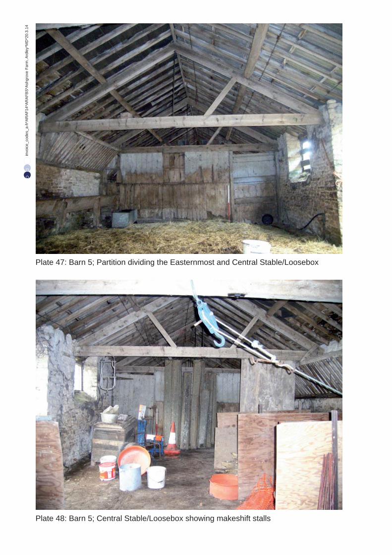
7.2.9 The partition to the west consists of a timber frame clad with timber planks to tie-beamheight. The planks have been worn smooth from years of contact with the horses or cowsusing the stable. A ledged door to tie-beam height is to the northern edge of the partition(Pl. 47).
7.2.10 The following three bays form the Central Stable. It is laid out identically to theeasternmost stable, including the surviving manger and hayrack, although makeshiftstalls have been created from modern plywood and steel posts (Pl. 48).
5 Ibid.
© Oxford Archaeology Page 11 of 19 March 2014

Ashgrove Farm, Oxfordshire Historic Building Recording and Investigation
7.2.11 The floor is visible and consists of sub-rectangular cobbles laid north-south, with adrainage channel created from narrower cobbles along the front through passage andtowards the door (Pl. 49).
7.2.12 The timber partition to the western end of the compartment has less signs of animal wearand so it may be concluded that this stable was laid out as stalls originally, allowing theanimals less freedom to rub against the timber cladding.
7.2.13 The next single-bayed compartment to the west is currently a Store Room. No fixturesindicate its former use.
7.2.14 Modern ply and chip boarding has been attached to the truss up to the apex above thepartition with the previous stable.
7.2.15 The floor is made up of pieces of broken flags over a thick mortar-based screed, mostlyobscured by the stored items.
7.2.16 One window and ledge and braced stable door, as per others in the range, are present.
7.2.17 A timber partition as per the previous two partitions, albeit missing its door, divides thebay from the room to the west (Pl. 50).
7.2.18 The remainder of the range is currently used as a Large Store Room and a Small StoreRoom and is referred to as 'Barn 4' in the architect's drawings.
7.2.19 The larger of the two stores is of six bays and is divided from 'Barn 5' by a timberpartition as described previously.
7.2.20 No original fittings are visible to indicate the original use of this part of the building andthe floor consists of modern concrete with a 12cm change of level within the fourth bayfrom the east (Pl. 51).
7.2.21 Of the two windows in the room, the easternmost window retains the two originalwooden beaded sliding casements, each of four panes. The doors in the dividing walls aremissing, but the external stable door is as the others in the range.
7.2.22 The final bay is divided from the larger store room by a roughly coursed limestone wall,reflecting the final bay at the opposite end of the range. The dividing door is missing.
7.2.23 The rear of the room is entirely taken up with a modern partitioned-off store room.
7.2.24 If the walled bay at the opposite end of the range is a tack or harness room, then it isfeasible that this would be the feed room, but the partitioning and concrete flooring hasobscured any features to give an indication of this.
© Oxford Archaeology Page 12 of 19 March 2014

Ashgrove Farm, Oxfordshire Historic Building Recording and Investigation
8 CONCLUSION
8.1.1 Ashgrove Farm in its current form displays four distinct phases of development. Theearliest phase is now represented only by the early-mid eighteenth-century threshingbarn.
8.1.2 The brick range associated with the farm house and the stable block attached to thethreshing barn lack distinct features for dating, however, they were present by thedrawing of the tithe map in 1839.
8.1.3 At some point between 1839 and 1894, the farmhouse, mainly in its current form, theworkshop building and the southernmost stable block had been constructed under theownership of the Duke of Marlborough.
8.1.4 By the mid twentieth century, modern agricultural buildings had been erected, reflectingthe industrialisation of farming seemingly more than the development of the farm in thenineteenth century.
8.1.5 During the later years of the twentieth century, the farming processes had moved towardsthe modern buildings, leaving the traditional buildings to be used increasingly for storageand resulting in the neglect and decline of the threshing barn. The threshing barn waslisted in 1988, but has since lost large areas of the mortar and stonework is degrading dueto the breakdown of the replacement roofing material. Few of the original windows ordoors to each building survives.
8.1.6 The intention is to move the farming processes to the east of the site, converting the farmbuildings in the scope of this study to domestic use. Some of the twentieth-centuryagricultural buildings have already been removed, and it is intended to remove themodern open barn during the works.
8.1.7 This building recording has attempted to capture the farm buildings and their uses beforethe next phase of development occurs.
Angela Warner
March 2014
© Oxford Archaeology Page 13 of 19 March 2014

Ashgrove Farm, Oxfordshire Historic Building Recording and Investigation
APPENDIX A. BIBLIOGRAPHY
Lobel MD (ed) Victoria County History: A History of the County of Oxford: Volume 6 (1959)
Maps
Tithe Map of Ardley 1839 [Oxfordshire Record Office Document Reference: 14/m]
Plan of the Freehold Estate situate at Ardley associated with the Sale Catalogue of the 3rd July1894 [Oxfordshire Record Office Document Reference: J.XII b/3]
Websites
www.bgs.ac.uk/discoveringGeology/geologyOfBritain/viewer.html?src=topNav
Accessed 7 March 2014
© Oxford Archaeology Page 14 of 19 March 2014

Ashgrove Farm, Oxfordshire Historic Building Recording and Investigation
APPENDIX B. LISTED BUILDING DESCRIPTION
ARDLEY A43 SP 52 NW (West side) 3/1 Barn approx. 30m N of Ashgrove Farmhouse (not included).
Grade: II
Date first listed: 26-Feb-1988
Barn. Early/mid C18. Coursed limestone rubble with wooden lintels; corrugated-sheet roof. 6-bay plan with opposed full-height doors in bay 3. Other bays have blocked slits, there is a blocked lower doorway in bay 5, a pitching door in the right gable, and both gables have triangular vents. Bay one and both end walls have small inserted doorways.
Interior: Trusses have tie beams, collars, and they support 2 rows of butt purlins.(VCH: Oxfordshire, Vol VI, p8)
Listing National Grid Reference: SP 53623 26212
© Oxford Archaeology Page 15 of 19 March 2014

Ashgrove Farm, Oxfordshire Historic Building Recording and Investigation
APPENDIX C. EXCERPTS FROM THE SALE CATALOGUE DESCRIPTION
Title Page Begins:
By Order Of His Grace The Duke Of Marlborough
Oxfordshire,
The Outlying Portions of the Blenheim Estates.
Selected paragraphs of Page 14:
Ardley.
Lot 10
The Desirable Freehold Property, known as Ashgrove Farm (free of Land Tax).
Superior and Well-Arranged Homestead, conveniently placed, a short distance from the main road;approached therefrom by a private carriage road, with a pair of cottages at the gates forming an Entrance Lodge.
THE FARM HOUSE
Is built of brick with slate roof; occupies a pleasant position, overlooking the park like meadows infront, having a southern aspect, and is approached through a Swing Entrance Gate by a carriage sweep leading to the Porch Entrance. The accommodation is as follows:-
On the Top Floor – Four good Attic Bedrooms; Cupboard on landing.
On the First Floor – Principal Bedroom, fitted with two Cupboards; Dressing Room adjoining; another Principal Bedroom, panelled in oak on two sides; two other best bedrooms; Cupboard on landing.
Front and Back Staircases.
On the Ground Floor – Entrance Hall; Dining Room, fitted with French casement windows opening on to Garden; Drawing Room, similarly fitted with French casement windows; large kitchen, stone paved; Pantry, fitted with shelves; Dairy, fitted with shelves; Store Room; Lavatory Cupboard; two Beer Cellars and Wine Cupboard.
Covered way in rear leading to Brew House, fitted with two coppers, brick oven, and sink. In covered way are two pumps of soft and hard water; Wood and Coal Houses, and three Fowl Houses at side.
THE FARM BUILDINGS
Are very commodious and well arranged. They are most substantially built of stone, with slate andStonefield slate roofing, and consists of:
© Oxford Archaeology Page 16 of 19 March 2014

Ashgrove Farm, Oxfordshire Historic Building Recording and Investigation
RANGE OF NAG STABLING,
Comprising Two Stall and One Loose Box, Stone paved and fitted with Mangers; Saddle Room, match boarded and fitted with Grate; Coach House, enclosed by folding doors; and Boot House, with passage way to front, and Granary over the whole range.
Range of Three Loose Boxes, stone paved; Harness Room; Cart Horse Stable to tie 8 horses, fittedwith Mangers and Racks; Chaff House; another Stable for 8 horses, fitted with Mangers and Racks; another Ditto for 8 horses similarly fitted; Harness Room; Loose Box fitted with Mangers and Racks; 14-bay Wagon Shed; 2-bay Barn, paved with bricks; Stackyard; Range of Three Cattle Sheds, fitted with Mangers, and with Three Yards, enclosed by high Rail Fencing, having Galvanise Iron Cisterns, with water laid on to each; Mill House, with Shepherd's Granary over; Chaff House, with Straw Loft over and Yard; Carpenter's Shop; Blacksmith's Shop and Shoeing House; Coal House and Implement Shed; Paved Path leading to Range of Four Piggeries, with enclosed Brick-paved Runs; Boiling House, fitted with Copper and Stove, with water laid on; another spacious Barn, paved with brick, and enclosed by two pairs of folding doors; Two Piggeries; Cowhouse to tie Six Cows, brick-paved and fitted with Manger, Calf Pen at end; another Cowhouse, now divided into Three Calf Pens, paved with bricks and fitted with Manger; spacious enclosed Yard, with folding doors to Meadow.
Water is laid on to several of the Buildings from a pond near the house, and is pumped up by a ram.
The Yards and Buildings are all drained into a liquid manure tank.
There is a Sheep-wash in Meadow.
© Oxford Archaeology Page 17 of 19 March 2014

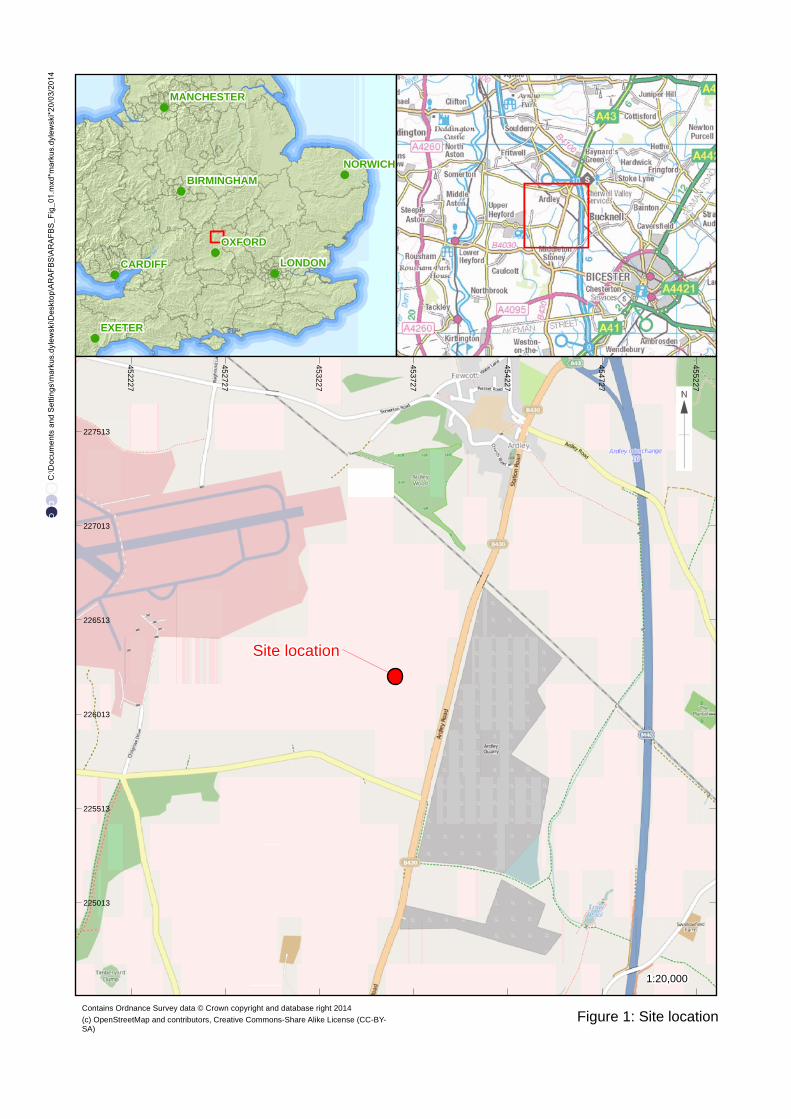
Figure 1: Site location
C:\D
ocum
ents
and
Set
tings
\mar
kus.
dyle
wsk
i\Des
ktop
\AR
AF
BS
\AR
AF
BS
_Fig
_01.
mxd
*mar
kus.
dyle
wsk
i*20
/03/
2014
LONDON
OXFORD
EXETER
NORWICH
CARDIFF
BIRMINGHAM
MANCHESTER
452227
452727
453227
453727
454227
454727
455227
225013
225513
226013
226513
227013
227513
Contains Ordnance Survey data © Crown copyright and database right 2014
Site location
1:20,000
(c) OpenStreetMap and contributors, Creative Commons-Share Alike License (CC-BY-SA)

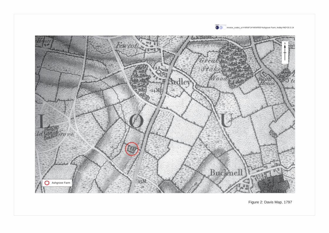
Figure 2: Davis Map, 1797
invoice_codes_a-h*ARAF14*ARAFBS*Ashgrove Farm, Ardley*MD*20.3.14
N
Ashgrove Farm


Figure 3: Tithe Map, 1839
invoice_codes_a-h*ARAF14*ARAFBS*Ashgrove Farm, Ardley*MD*20.3.14
N


Figure 4: Plan associated with the Sale Catalogue, 1894
invoice_codes_a-h*ARAF14*ARAFBS*Ashgrove Farm, Ardley*MD*20.3.14
N


Figure 5: Barn Numbering Convention (taken from the architect’s plan of the proposed layout)
invoice_codes_a-h*ARAF14*ARAFBS*Ashgrove Farm, Ardley*MD*20.3.14
N
1:750
0 50 m


Roller door hung outside Passageway
Ground floor of modern carpenter’s workshop
Modernstairway
Landing(redundant)
Landing Mill House
BlockedBlocked
Machinery
Drive machinery
Cow Barn
Location of existing limestone wall
General workshop Oil drum storeWarming room
Fireplace
Flue
Open front
Farrier’s workshop
1:100
0 5 m
Figure 6: Barn 2, ground floor
invoice_codes_a-h*ARAF14*ARAFBS*Ashgrove Farm, Ardley*MD*20.3.14

Modern carpenter’s workshop
Modernstairway
Void over passageway
Shepherd’sgranary
Boxedin
Blocked
Blocked
Blocked
Drive machineryBlocked door
1:100
0 5 m
Figure 7: Barn 2, first floor
invoice_codes_a-h*ARAF14*ARAFBS*Ashgrove Farm, Ardley*MD*20.3.14


Lean-to
Threshing barn
Pigsties
Not accessed
Building not in study
1:100
0 5 m
Figure 8: Barn 3
invoice_codes_a-h*ARAF14*ARAFBS*Ashgrove Farm, Ardley*MD*20.3.14


Small modernstore room
Main modernstore room
Store room
Missingdoor
Window
Central loose box
Eastern mostloose box
Tack room
1:150
0 5 m
Figure 9: Barn 4 and Barn 5
invoice_codes_a-h*ARAF14*ARAFBS*Ashgrove Farm, Ardley*MD*20.3.14


invo
ice_
code
s_a-
h*A
RA
F14*
AR
AFB
S*A
shgr
ove
Farm
, Ard
ley*
MD
*20.
3.14
Plate 1: Main farmhouse building; south elevation
Plate 2: Farmhouse building; detail of fi rst fl oor addition and pitching door; north elevation

invo
ice_
code
s_a-
h*A
RA
F14*
AR
AFB
S*A
shgr
ove
Farm
, Ard
ley*
MD
*20.
3.14
Plate 3: Stable or loosebox to the west of the threshing barn; south elevation
Plate 4: Stable or loosebox to the west of the threshing barn; north elevation

invo
ice_
code
s_a-
h*A
RA
F14*
AR
AFB
S*A
shgr
ove
Farm
, Ard
ley*
MD
*20.
3.14
Plate 5: Black barn and modern building to the far eastern end of the site; looking east
Plate 6: Modern building to the far eastern end of the site; north elevation

invo
ice_
code
s_a-
h*A
RA
F14*
AR
AFB
S*A
shgr
ove
Farm
, Ard
ley*
MD
*20.
3.14
Plate 7: Silo bases and the bases of removed modern buildings; looking west
Plate 8: Barn 1; north elevation

invo
ice_
code
s_a-
h*A
RA
F14*
AR
AFB
S*A
shgr
ove
Farm
, Ard
ley*
MD
*20.
3.14
Plate 9: Barn 1 rear wall; view from cowsheds looking north
Plate 10: Barn 2; north and west elevations

invo
ice_
code
s_a-
h*A
RA
F14*
AR
AFB
S*A
shgr
ove
Farm
, Ard
ley*
MD
*20.
3.14
Plate 11: Barn 2; south elevation
Plate 12: Barn 2; west elevation
invo
ice_
code
s_a-
h*A
RA
F14*
AR
AFB
S*A
shgr
ove
Farm
, Ard
ley*
MD
*20.
3.14
Plate 13: Barn 2; east elevation
Plate 14: Barn 2; east end of north elevation

invo
ice_
code
s_a-
h*A
RA
F14*
AR
AFB
S*A
shgr
ove
Farm
, Ard
ley*
MD
*20.
3.14
Plate 15: Barn 2; central passageway looking east
Plate 16: Barn 2; dividing wall between Shepherd’s Granary and void over passageway

invo
ice_
code
s_a-
h*A
RA
F14*
AR
AFB
S*A
shgr
ove
Farm
, Ard
ley*
MD
*20.
3.14
Plate 17: Barn 2; Roof truss in Modern Carpenter’s Workshop
Plate 18: Barn 2; Roof truss in the General Workshop

invo
ice_
code
s_a-
h*A
RA
F14*
AR
AFB
S*A
shgr
ove
Farm
, Ard
ley*
MD
*20.
3.14
Plate 19: Barn 2; fi replace in the Warming Room
Plate 20: Barn 2; Warming Room window

invo
ice_
code
s_a-
h*A
RA
F14*
AR
AFB
S*A
shgr
ove
Farm
, Ard
ley*
MD
*20.
3.14
Plate 21: Barn 2; Farrier’s Workshop
Plate 22: Barn 2; General Workshop showing blocking of large opening
invo
ice_
code
s_a-
h*A
RA
F14*
AR
AFB
S*A
shgr
ove
Farm
, Ard
ley*
MD
*20.
3.14
Plate 23: Barn 2; Oil Drum Store
Plate 24: Barn 2; Modern Carpenter’s Shop, ground fl oor looking east

invo
ice_
code
s_a-
h*A
RA
F14*
AR
AFB
S*A
shgr
ove
Farm
, Ard
ley*
MD
*20.
3.14
Plate 25: Barn 2; Modern Carpenter’s Shop, ground fl oor looking west
Plate 26: Barn 2; Modern Carpenter’s Shop, fi rst fl oor looking east

invo
ice_
code
s_a-
h*A
RA
F14*
AR
AFB
S*A
shgr
ove
Farm
, Ard
ley*
MD
*20.
3.14
Plate 27: Barn 2; Modern Carpenter’s Shop, fi rst fl oor looking west
Plate 28: Barn 2; Mill House steps and landing looking west

invo
ice_
code
s_a-
h*A
RA
F14*
AR
AFB
S*A
shgr
ove
Farm
, Ard
ley*
MD
*20.
3.14
Plate 29: Barn 2; drive machinery between the Mill House and Passageway
Plate 30: Barn 3; south elevation

invo
ice_
code
s_a-
h*A
RA
F14*
AR
AFB
S*A
shgr
ove
Farm
, Ard
ley*
MD
*20.
3.14
Plate 31: Barn 3; north elevation
Plate 32: Barn 3; east elevation

invo
ice_
code
s_a-
h*A
RA
F14*
AR
AFB
S*A
shgr
ove
Farm
, Ard
ley*
MD
*20.
3.14
Plate 33: Barn 3; blocked doorway in the south wall
Plate 34: Barn 3; opening for modern machinery in the north wall

invo
ice_
code
s_a-
h*A
RA
F14*
AR
AFB
S*A
shgr
ove
Farm
, Ard
ley*
MD
*20.
3.14
Plate 35: Barn 3; Pigsties to the south of the threshing barn looking west
Plate 36: Barn 3; Pigsties and associated building looking south west

invo
ice_
code
s_a-
h*A
RA
F14*
AR
AFB
S*A
shgr
ove
Farm
, Ard
ley*
MD
*20.
3.14
Plate 37: Barn 3; truss
Plate 38: Barn 3; stopped chamfered tie-beam

invo
ice_
code
s_a-
h*A
RA
F14*
AR
AFB
S*A
shgr
ove
Farm
, Ard
ley*
MD
*20.
3.14
Plate 39: Barn 3; threshing fl oor and storage bay fl oor looking north east
Plate 40: Barn 5; south elevation looking north east
invo
ice_
code
s_a-
h*A
RA
F14*
AR
AFB
S*A
shgr
ove
Farm
, Ard
ley*
MD
*20.
3.14
Plate 41: Barn 5; east and north elevations looking south west
Plate 42: Barns 4 & 5; join between the block and the farmhouse on the north elevation

invo
ice_
code
s_a-
h*A
RA
F14*
AR
AFB
S*A
shgr
ove
Farm
, Ard
ley*
MD
*20.
3.14
Plate 43: Barns 4 & 5; join between the block and the farmhouse on the south elevation
Plate 44: Barn 5; truss

invo
ice_
code
s_a-
h*A
RA
F14*
AR
AFB
S*A
shgr
ove
Farm
, Ard
ley*
MD
*20.
3.14
Plate 45: Barn 5; manger and hayrack along south wall in the Easternmost Stable/Loosebox
Plate 46: Barn 5; Tackroom
invo
ice_
code
s_a-
h*A
RA
F14*
AR
AFB
S*A
shgr
ove
Farm
, Ard
ley*
MD
*20.
3.14
Plate 47: Barn 5; Partition dividing the Easternmost and Central Stable/Loosebox
Plate 48: Barn 5; Central Stable/Loosebox showing makeshift stalls

invo
ice_
code
s_a-
h*A
RA
F14*
AR
AFB
S*A
shgr
ove
Farm
, Ard
ley*
MD
*20.
3.14
Plate 49: Barn 5; Central Stable/Loosebox fl oor detail
Plate 50: Barn 4 & 5; Partition of Store at west end of Barn 5 and Large Store of Barn 4

invo
ice_
code
s_a-
h*A
RA
F14*
AR
AFB
S*A
shgr
ove
Farm
, Ard
ley*
MD
*20.
3.14
Plate 51: Barn 4; General Shot looking west


Di rec to r : G i l l H e y , B A P h D F S A M I F A
Oxf o rd A rchaeo l ogy L td i s a
P r i va te L i m i ted C om pany , N o : 1618597
and a Reg i s te red Char i t y , No : 285627
OA Nor thMi l l 3Moor LaneLancas te r LA1 1QD
t : +44 ( 0 ) 1524 541 000f : +44 ( 0 ) 1524 848 606e : oanor th@ox fo rda rchaeo lo g y .co mw:h t tp : / /ox fo rda rchaeo logy .co m
Head Of f ice/Reg i s te red O f f ice/OA Sou th
Janus HouseOsney MeadOxfo rd OX2 0ES
t : +44 ( 0 ) 1865 263 800f : +44 ( 0 )1865 793 496e : i n fo@ox fo rda rchaeo logy .c o mw:h t tp : / /ox fo rda rchaeo logy .co m
OA Eas t
15 T r a fa lga r WayBar H i l lCambr idgesh i reCB23 8SQ
t : +44 (0 )1223 850500e : oaeas t@ox fo rda rchaeo logy .co mw:h t tp : / /ox fo rda rchaeo logy .co m