Embed Size (px)
Citation preview
As presented to BCC Cabinet November 2016
Appendix 1
West of England Joint Spatial Plan Joint Spatial Plan – Towards the emerging Spatial Strategy Consultation
Introduction
1. The Joint Spatial Plan ‘Issues and Options’ document was consulted upon between
9th November 2015 and 29th January 2016. The responses to the consultation and the summary consultation report which have informed this document can be found here: https://www.jointplanningwofe.org.uk/ .
2. This document is the second phase of consultation to inform the draft Joint Spatial Plan which is intended to be adopted in 2018.
3. The West of England (WoE) currently faces a key challenge: how to accommodate
and deliver much needed new homes and jobs properly supported by infrastructure to create attractive places, while maintaining the environmental assets and quality of life unique to our area. The scale of the issue to be addressed requires an ambitious strategic response.
4. The local authorities of Bath and North East Somerset Council, Bristol City Council,
North Somerset Council and South Gloucestershire Council have joined forces to prepare the Joint Spatial Plan (JSP). The JSP will be a statutory Development Plan Document that will provide the strategic overarching development framework for the West of England to 2036.
5. A Joint Transport Study (JTS) is being undertaken to develop future strategic
transport proposals for delivery up to 2036 that address current challenges on the network and to inform future development proposals. This work will inform the JSP. This joint approach to planning and transport will ensure that future growth decisions are made with an understanding of the necessary transport investment needed to achieve sustainable communities.
Purpose of the Joint Spatial Plan
6. The four authorities are committed to a positive plan-led approach. This is consistent
with the Government’s core planning principles and the Duty to Cooperate. Whilst the JSP is not a detailed land use plan, it is a statutory Development Plan Document and will form the strategic policy for individual Local Plans prepared by the four Authorities going forwards. The scope of the JSP, with its supporting evidence base, is intentionally focused on:
• identifying the number of new market and affordable homes and amount of employment land that is needed across the West of England 2016-2036.
• setting out the most appropriate spatial strategy and strategic locations for where this
growth should be to meet the needs identified. The outcome of this process will be
housing apportionments for each authority in the final JSP.
• identifying the transport and other infrastructure that needs to be provided in the right place and at the right time to support sustainable growth and to provide certainty for our communities and those that want to invest in our area.
Relationship of the Joint Spatial Plan to Local Plans
7. The JSP will, in due course, carry significant weight and be used to inform key
planning decisions. Whilst it will not replace existing local plans, in due course it will be a material consideration in decision making. In the meantime, existing local plans will continue to deliver existing Core Strategy targets.Local plan reviews will need to respond to the new strategic context. The JSP will eventually (when adopted) provide the new higher level strategic planning framework for the four authorities to 2036.
8. Given the early stage that the JSP is at, and in the spirit of early engagement on options, the JSP will not carry significant weight at this time which would be premature.
9. The Housing and Planning Act 2016 has a new route for planning permission for housing led development called ‘planning permission in principle’ or PIP. A PIP may be granted for housing-led development either on application to the local planning authority (or Secretary of State in some instances), or through qualifying documents. The JSP is not expected to be a qualifying document for establishing planning permission in principle.. The JSP Spatial Strategy will identify strategic development locations which will be brought forward as allocations through the local plan process.
Purpose of this document
10. During the public consultation on the Issues and Options document we set out potential strategic locations classified by broad typologies and asked for comments on five potential generalised spatial scenarios to base the Plan’s spatial strategy upon. These are listed below and pictorial representations of the first three are shown:
• Protection of the Green Belt • Concentration at Bristol Urban Area • Transport Focused • A more even spread of development across the sub-region • New Settlement or (a limited number of expanded settlements).
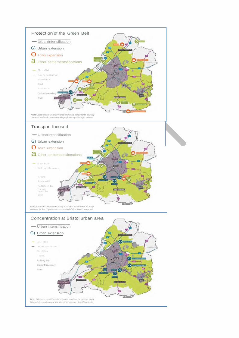
Protection of the Green Belt •Urban intensification
G) Urban extension
0 Town expansion
a Other settlements/locations • G. nBd
• £ t:l'tt ng settleme
MctnrNilV A
fload
Ralw.wh e-
Note: Locati<ms ore WvsrratiVI!Onfy and must not be rokffl ro ;mp.'y onv SIJf!C{/ic devttlcpment sftq oro preference fot identifid o ons
Transport focused
•Urban intensification
G) Urban extension
0 Town expansion
a Other settlements/locations • S-een B.,.•l
• Ew1 1ng t11emcnt ,
b, Ronrl
R;;alw.avfi'l
Port1she c I11e
Co\Jrt!l bpund;'i•y
Olvc'
Note; locations CJre 1llv5uorr.;e only o1fd tt'ILSt not bf! taken ro ;mply DtW spec.'fk dev /OpmMt srh!' «o pre/ereltC4{or *l!enrlf,ed optJons
Concentration at Bristol urban area
•Urban intensification
G) Urban extension • GH.· nBt!t
• :t(IO:tiOf c;rtt1Pfl1Pntr.
l\lfn nf'V/i1y
"-Ro-tC'
Nou:: LOcouoos ore til11stroti'W! on(v ond must nor be roken to imply Dfty spl'cl{!c devt'/cpmenl sire at a prt-jH nceJar ukmtild optkwls
11. A wide range of views were expressed through the consultation. Broad support was indicated for one or a combination of both of the following options: 1) Protection of the Green Belt 2) Transport Focussed.
12. Following the outcome of the consultation, further technical work has been undertaken to look at the range of locations across the West of England and test the merit of alternative approaches and scenarios. W e have sought to draw out components of each of the options that people valued and have distilled those into a single draft emerging spatial strategy. A wider range of factors and issues including transport , sustainability, green belt, environmental, community building, place making, protecting valued landscapes and places have been considered. This has come together to produce a pragmatic, deliverable plan which overall produces a balanced strategy which best delivers the plan’s objectives. This has been tested against the objectives of the Sustainability Appraisal and strategic modelling of the transport impacts as part of the Joint Transport Study. Topic Paper 1 sets out the full methodology for preparing the Spatial Strategy.
What happens now?
13. Before the plan preparation progresses to the publication plan (final draft plan), we
want to seek people’s views now on the emerging spatial strategy in this document. The strategy is not fixed and we recognise that further work is necessary including taking on board comments from this additional stage of consultation. The additional stage of consultation has been undertaken as it is critical to ensure everyone can have an opportunity to comment and help shape the emerging spatial scenario. This is particularly important as no alternative spatial strategy was put forward at the Issues and Options stage and we want to ensure that the opportunity is provided for alternatives to come forward.
14. This draft document on Towards the Emerging Spatial Strategy and supporting
evidence is open to consultation between 7th November and 16th December 2016. This consultation is being undertaken jointly with the consultation on the Joint Transport Study, The work streams are closely linked and consultation responses will inform both the final draft of the plan and the transport vision in the joint transport study.
Preparing the final draft JSP and Timetable for the plan
15. The JSP is being prepared in accordance with the Planning and Compulsory Purchase Act 2004.
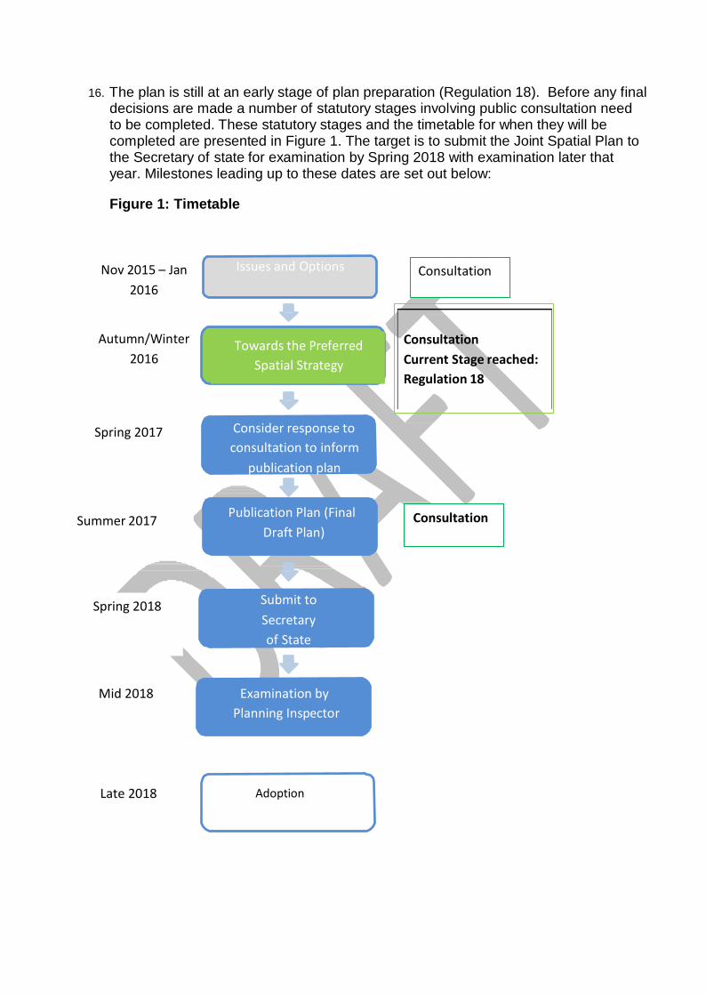
16. The plan is still at an early stage of plan preparation (Regulation 18). Before any final decisions are made a number of statutory stages involving public consultation need to be completed. These statutory stages and the timetable for when they will be completed are presented in Figure 1. The target is to submit the Joint Spatial Plan to the Secretary of state for examination by Spring 2018 with examination later that year. Milestones leading up to these dates are set out below:
Figure 1: Timetable
Nov 2015 – Jan 2016
Issues and Options Consultation
Autumn/Winter 2016
Towards the Preferred Spatial Strategy
Consultation Current Stage reached: Regulation 18
Spring 2017 Consider response to consultation to inform
publication plan
Summer 2017 Publication Plan (Final Draft Plan)
Consultation
Spring 2018 Submit to Secretary of State
Mid 2018 Examination by Planning Inspector
Late 2018 Adoption
Vision and Objectives
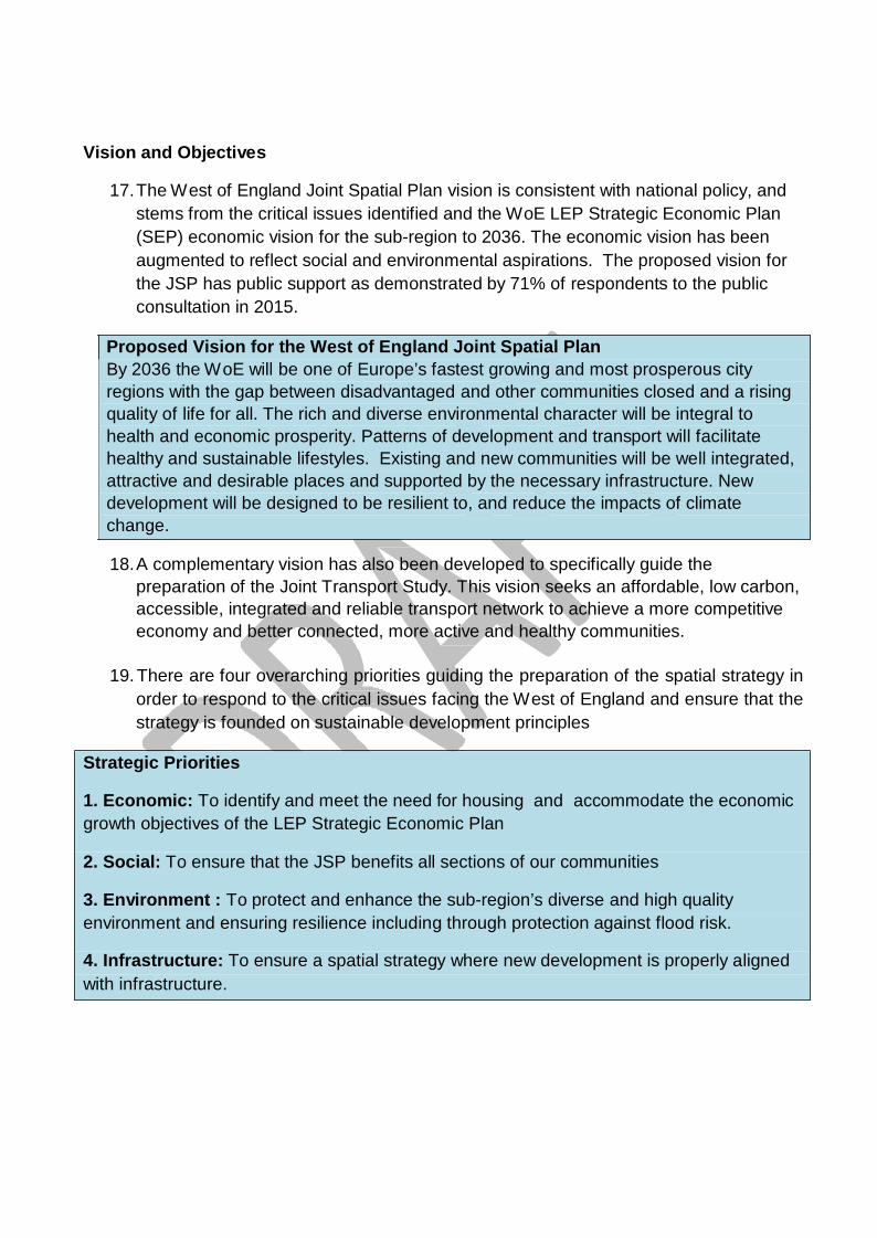
17. The West of England Joint Spatial Plan vision is consistent with national policy, and
stems from the critical issues identified and the WoE LEP Strategic Economic Plan (SEP) economic vision for the sub-region to 2036. The economic vision has been augmented to reflect social and environmental aspirations. The proposed vision for the JSP has public support as demonstrated by 71% of respondents to the public consultation in 2015.
Proposed Vision for the West of England Joint Spatial Plan By 2036 the W oE will be one of Europe’s fastest growing and most prosperous city regions with the gap between disadvantaged and other communities closed and a rising quality of life for all. The rich and diverse environmental character will be integral to health and economic prosperity. Patterns of development and transport will facilitate healthy and sustainable lifestyles. Existing and new communities will be well integrated, attractive and desirable places and supported by the necessary infrastructure. New development will be designed to be resilient to, and reduce the impacts of climate change.
18. A complementary vision has also been developed to specifically guide the
preparation of the Joint Transport Study. This vision seeks an affordable, low carbon, accessible, integrated and reliable transport network to achieve a more competitive economy and better connected, more active and healthy communities.
19. There are four overarching priorities guiding the preparation of the spatial strategy in
order to respond to the critical issues facing the West of England and ensure that the strategy is founded on sustainable development principles
Strategic Priorities
1. Economic: To identify and meet the need for housing and accommodate the economic growth objectives of the LEP Strategic Economic Plan
2. Social: To ensure that the JSP benefits all sections of our communities
3. Environment : To protect and enhance the sub-region’s diverse and high quality environment and ensuring resilience including through protection against flood risk.
4. Infrastructure: To ensure a spatial strategy where new development is properly aligned with infrastructure.
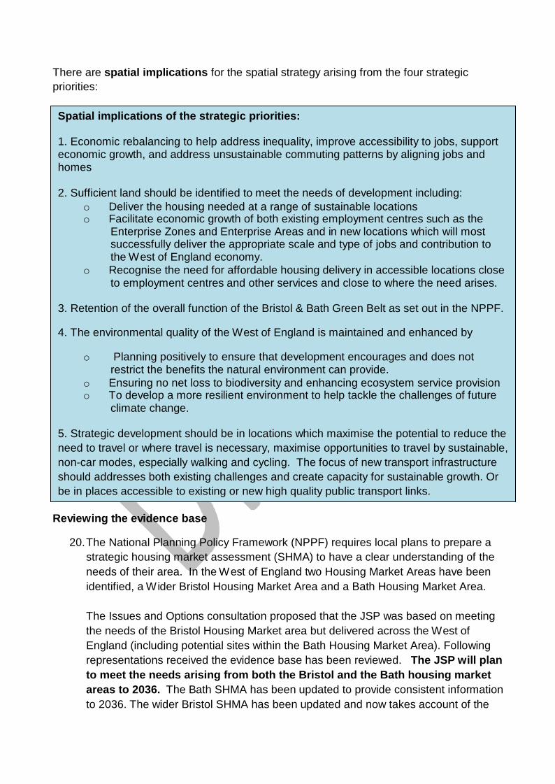
There are spatial implications for the spatial strategy arising from the four strategic priorities:
Spatial implications of the strategic priorities:
1. Economic rebalancing to help address inequality, improve accessibility to jobs, support economic growth, and address unsustainable commuting patterns by aligning jobs and homes
2. Sufficient land should be identified to meet the needs of development including:
o Deliver the housing needed at a range of sustainable locations o Facilitate economic growth of both existing employment centres such as the
Enterprise Zones and Enterprise Areas and in new locations which will most successfully deliver the appropriate scale and type of jobs and contribution to the West of England economy.
o Recognise the need for affordable housing delivery in accessible locations close to employment centres and other services and close to where the need arises.
3. Retention of the overall function of the Bristol & Bath Green Belt as set out in the NPPF.
4. The environmental quality of the West of England is maintained and enhanced by
o Planning positively to ensure that development encourages and does not
restrict the benefits the natural environment can provide. o Ensuring no net loss to biodiversity and enhancing ecosystem service provision o To develop a more resilient environment to help tackle the challenges of future
climate change.
5. Strategic development should be in locations which maximise the potential to reduce the need to travel or where travel is necessary, maximise opportunities to travel by sustainable, non-car modes, especially walking and cycling. The focus of new transport infrastructure should addresses both existing challenges and create capacity for sustainable growth. Or be in places accessible to existing or new high quality public transport links.
Reviewing the evidence base
20. The National Planning Policy Framework (NPPF) requires local plans to prepare a
strategic housing market assessment (SHMA) to have a clear understanding of the needs of their area. In the West of England two Housing Market Areas have been identified, a W ider Bristol Housing Market Area and a Bath Housing Market Area.
The Issues and Options consultation proposed that the JSP was based on meeting the needs of the Bristol Housing Market area but delivered across the West of England (including potential sites within the Bath Housing Market Area). Following representations received the evidence base has been reviewed. The JSP will plan to meet the needs arising from both the Bristol and the Bath housing market areas to 2036. The Bath SHMA has been updated to provide consistent information to 2036. The wider Bristol SHMA has been updated and now takes account of the
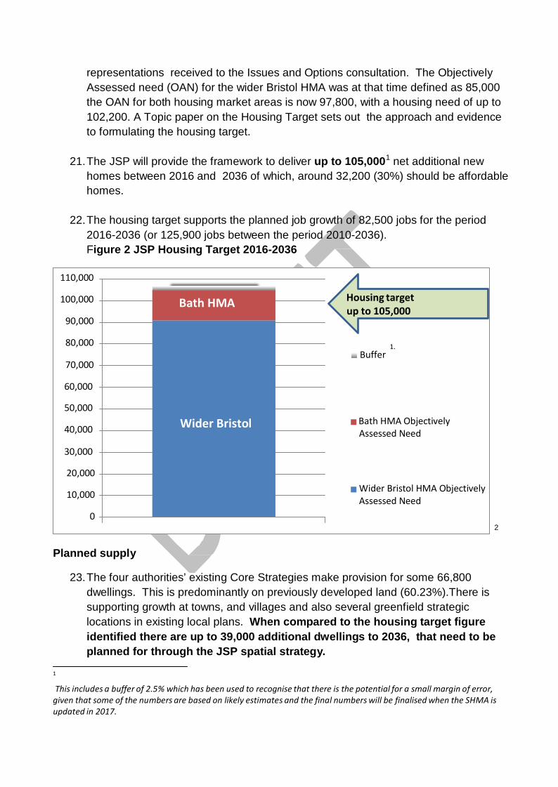
representations received to the Issues and Options consultation. The Objectively Assessed need (OAN) for the wider Bristol HMA was at that time defined as 85,000 the OAN for both housing market areas is now 97,800, with a housing need of up to 102,200. A Topic paper on the Housing Target sets out the approach and evidence to formulating the housing target.
21. The JSP will provide the framework to deliver up to 105,0001 net additional new
homes between 2016 and 2036 of which, around 32,200 (30%) should be affordable homes.
22. The housing target supports the planned job growth of 82,500 jobs for the period 2016-2036 (or 125,900 jobs between the period 2010-2036). Figure 2 JSP Housing Target 2016-2036
110,000
100,000
90,000
80,000
70,000
Bath HMA Housing target
up to 105,000
1. Buffer
60,000
50,000
40,000
30,000
Wider Bristol Bath HMA Objectively
Assessed Need
20,000
10,000
0
Wider Bristol HMA Objectively Assessed Need
2
Planned supply
23. The four authorities’ existing Core Strategies make provision for some 66,800
dwellings. This is predominantly on previously developed land (60.23%).There is supporting growth at towns, and villages and also several greenfield strategic locations in existing local plans. When compared to the housing target figure identified there are up to 39,000 additional dwellings to 2036, that need to be planned for through the JSP spatial strategy.
1
This includes a buffer of 2.5% which has been used to recognise that there is the potential for a small margin of error, given that some of the numbers are based on likely estimates and the final numbers will be finalised when the SHMA is updated in 2017.
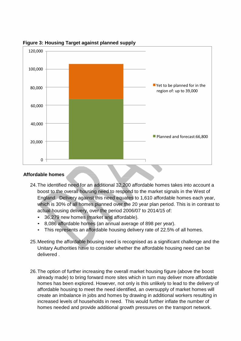
Figure 3: Housing Target against planned supply
120,000
100,000
80,000 Yet to be planned for in the region of: up to 39,000
60,000
40,000
20,000 Planned and forecast:66,800
0 Affordable homes
24. The identified need for an additional 32,200 affordable homes takes into account a
boost to the overall housing need to respond to the market signals in the West of England. Delivery against this need equates to 1,610 affordable homes each year, which is 30% of all homes planned over the 20 year plan period. This is in contrast to actual housing delivery, over the period 2006/07 to 2014/15 of: • 36,279 new homes (market and affordable). • 8,086 affordable homes (an annual average of 898 per year). • This represents an affordable housing delivery rate of 22.5% of all homes.
25. Meeting the affordable housing need is recognised as a significant challenge and the
Unitary Authorities have to consider whether the affordable housing need can be delivered .
26. The option of further increasing the overall market housing figure (above the boost already made) to bring forward more sites which in turn may deliver more affordable homes has been explored. However, not only is this unlikely to lead to the delivery of affordable housing to meet the need identified, an oversupply of market homes will create an imbalance in jobs and homes by drawing in additional workers resulting in increased levels of households in need. This would further inflate the number of homes needed and provide additional growth pressures on the transport network.
Hence this approach is contrary to providing a sustainable balanced strategy for growth and is likely to have a detrimental impact on wider principles of the Plan as well as destabilising the plans of adjoining Local Planning Authorities who are also promoting a plan led approach to planning for sustainable economic growth.
27. Challenges in delivering affordable housing to meet identified need are not unique to
the West of England; the nature and scale of issues and policy landscape is national. There is a significant implementation gap between levels of need and planned numbers of affordable homes that can be realistically delivered by the development industry. It is recognised that the Unitary Authorities will need to work with partners and use other mechanisms as well as the planning system to maximise delivery of affordable homes needed.
28. On balance therefore it is clear that it is unrealistic and unsustainable for the Plan
alone to meet the full amount of affordable housing identified. This is a judgement that has involved a careful balancing exercise that has taken into account all of the factors set out above.
29. It is recognised that other areas in the country have experienced the same issues
and have instead set out what can be achieved through their respective Spatial Strategies.
30. It should be noted that if there is a review of the affordable housing definition in
national planning policy to include Starter Homes, then the 32,200 affordable housing need would need reviewing. This is because many of the households who aspire to home ownership but cannot afford to buy market housing in the Plan area (those who may be eligible for Starter Homes) can afford to rent market housing. Therefore they are not counted within the affordable housing need of 32,200 dwellings (which is based on those who cannot afford to buy or rent at market rates in the market area).
31. In the absence of regulations explaining the introduction of Starter Homes in more
detail the Authorities’ technical assessment has assumed that 20% starter homes will apply on all the new strategic development locations as they come forward.
32. This means that traditional affordable homes (as currently defined in national and
local policy) will make up the balance of the policy requirement. In practice, the % of traditional affordable housing should be higher if equivalent viability is maintained. However it is not possible to confirm this at this time. It is also unknown whether existing Core Strategy commitments could be impacted by the introduction of Starter Homes. Therefore current projections, taking into account the impact of starter homes on new strategic development locations, are that 17,100 traditional affordable homes can be delivered against the housing need of 32,200 (53%).
33. The assumption of 20% Starter Homes on new strategic development locations equates to the delivery of 7,740 homes, contributing towards the overall housing target.
34. We are seeking views on this proposed approach to the emerging spatial
strategy.
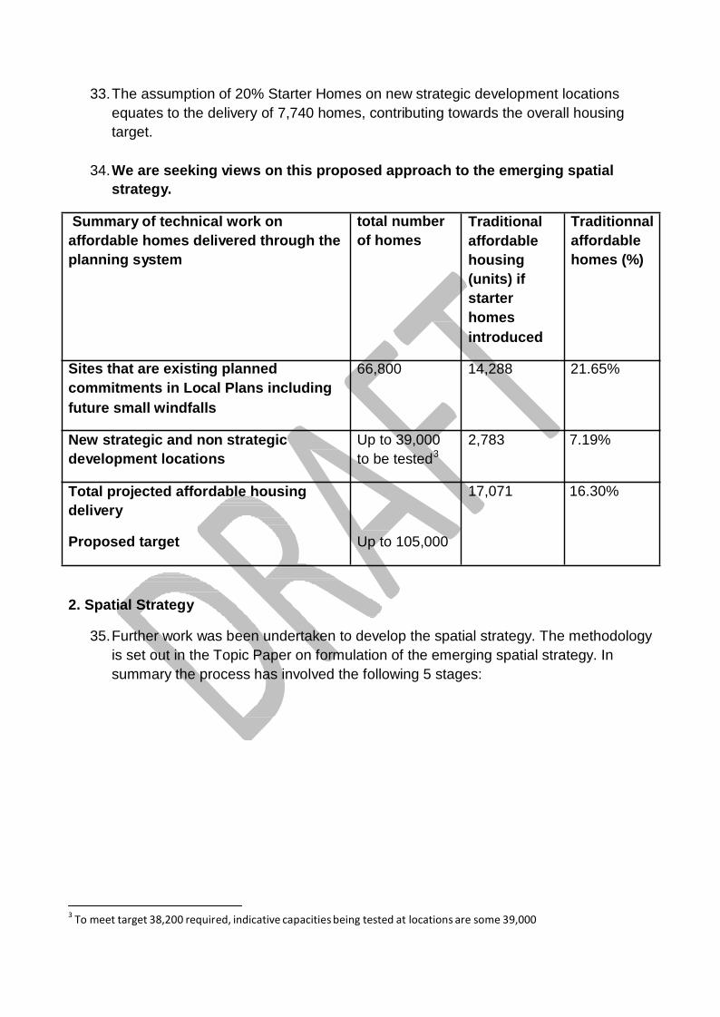
Summary of technical work on affordable homes delivered through the planning system
total number of homes
Traditional affordable housing (units) if starter homes introduced
Traditionnal affordable homes (%)
Sites that are existing planned commitments in Local Plans including future small windfalls
66,800 14,288 21.65%
New strategic and non strategic development locations
Up to 39,000 to be tested3
2,783 7.19%
Total projected affordable housing delivery
17,071 16.30%
Proposed target Up to 105,000
2. Spatial Strategy
35. Further work was been undertaken to develop the spatial strategy. The methodology
is set out in the Topic Paper on formulation of the emerging spatial strategy. In summary the process has involved the following 5 stages:
3 To meet target 38,200 required, indicative capacities being tested at locations are some 39,000
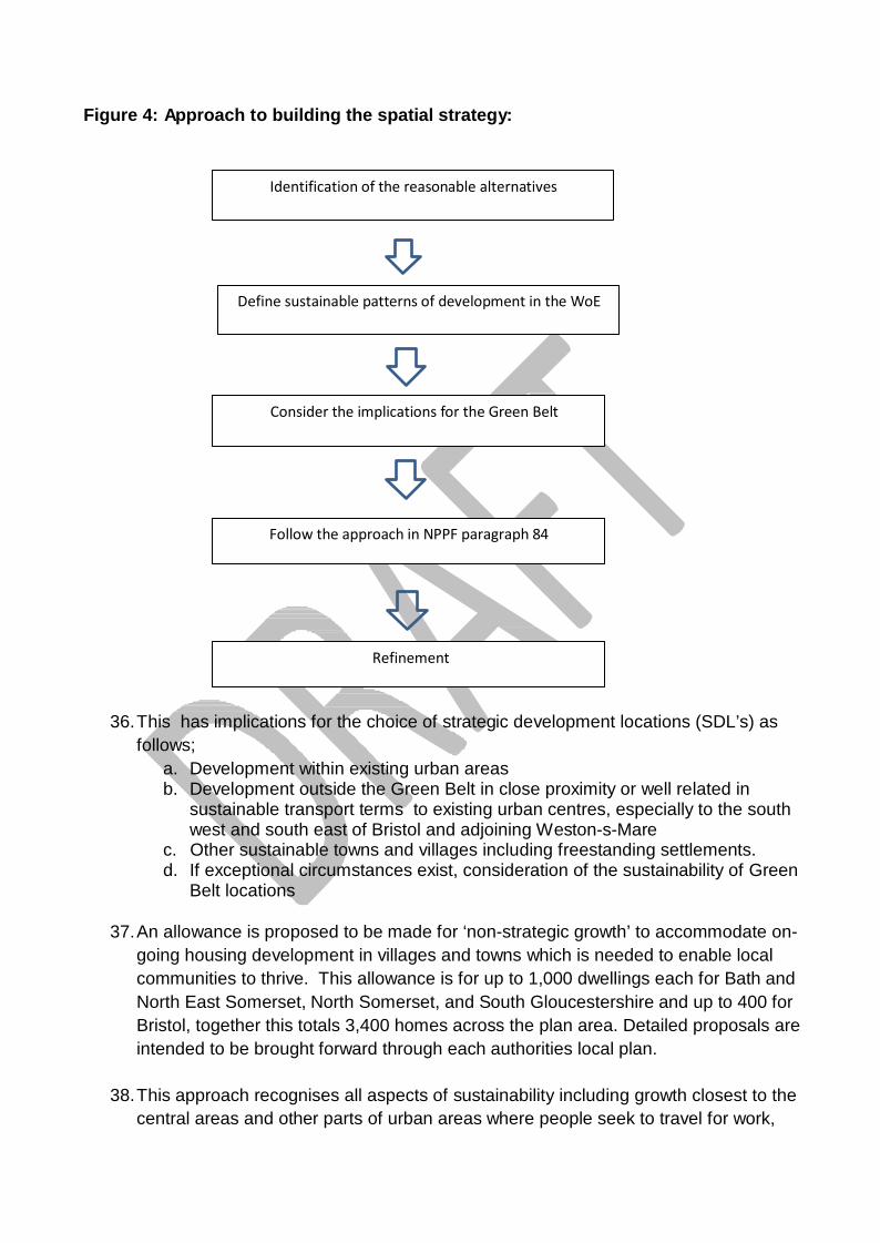
Figure 4: Approach to building the spatial strategy:
Identification of the reasonable alternatives
Define sustainable patterns of development in the WoE
Consider the implications for the Green Belt
Follow the approach in NPPF paragraph 84
Refinement
36. This has implications for the choice of strategic development locations (SDL’s) as follows;
a. Development within existing urban areas b. Development outside the Green Belt in close proximity or well related in
sustainable transport terms to existing urban centres, especially to the south west and south east of Bristol and adjoining Weston-s-Mare
c. Other sustainable towns and villages including freestanding settlements. d. If exceptional circumstances exist, consideration of the sustainability of Green
Belt locations
37. An allowance is proposed to be made for ‘non-strategic growth’ to accommodate on- going housing development in villages and towns which is needed to enable local communities to thrive. This allowance is for up to 1,000 dwellings each for Bath and North East Somerset, North Somerset, and South Gloucestershire and up to 400 for Bristol, together this totals 3,400 homes across the plan area. Detailed proposals are intended to be brought forward through each authorities local plan.
38. This approach recognises all aspects of sustainability including growth closest to the
central areas and other parts of urban areas where people seek to travel for work,
shopping and recreational needs. Sustainability is closely related, but not entirely, to proximity. Other sustainability factors to meet the priorities of the plan also need to be considered including rebalancing economic growth, maintaining and enhancing the environment and retaining the overall function of the Green Belt. A balanced approach has been taken.
39. The current and anticipated future locations which are significant generators of trips
are central Bristol, the existing communities of the Bristol North Fringe, central Bath/Bath Enterprise Zone and Weston-super-Mare. However, this approach which focusses on increasing existing urban development opportunities and expansion will not be sufficient to meet the homes and job needs of the Region over the next 20 years. Additional new sustainable locations will be needed which may include new approaches such as new neighbourhoods, or garden villages. The spatial strategy identifies locations for these, recognising their current proximity and access to central Bristol, Bath and W eston super-Mare and their potential to utilise existing and new transport corridor opportunities. Evidence shows that due to significant environmental constraints there is no scope to further expand Bath outwards.
40. Alongside this, it is also recognised that existing towns and larger villages have a
role to play in supporting sustainable economic growth. Strategic opportunities have been identified where investment in high profile public transport will assist in delivering sustainable growth.
41. A sizeable proportion (48%) of the West of England is part of the Bristol-Bath Green
Belt. This has significant implications for the spatial strategy, particularly reflecting the strategic priority to retain the overall function of the Green Belt. The advice in NPPF para 83 is “Once established, Green Belt boundaries should only be altered in exceptional circumstances, through the preparation or review of the Local Plan. At that time, authorities should consider the Green Belt boundaries having regard to their intended permanence in the long term, so that they should be capable of enduring beyond the plan period.”
42. Technical work and transport modelling show that it is not possible to sustainably
accommodate the identified growth needs entirely outside the Green Belt. The transport impacts cannot be fully mitigated even with substantial investment. Such a strategy would be dependent on some highly unsustainable locations that are very difficult and expensive to mitigate with only sub-optimal solutions. It would also put pressure to locate development in the floodplain, and these issues would impact delivery of such a strategy.
43. In response to public consultation, the spatial strategy aims to minimise development
within the Bristol and Bath Green Belt. However, due to the scale of provision required and the extensive nature of the Green Belt, the plan does include certain sites currently with Green Belt designation. Land is proposed to be released from the
Green Belt, south east of Bristol as explained in the Spatial Strategy methodology paper. There may be potential through the plan’s preparation to explore whether areas could be included within the Green Belt to ensure no net loss of the overall green belt. There are no firm proposals at this time. Finally, the opportunity for a new free standing settlement has been explored. Through the Issues and options consultation a garden village of Buckover to the east of Thornbury was identified.
Urban Living (maximising the potential of urban areas)
44. Urban Living is a central plank of the Spatial Strategy, and commands a high degree
of public support. The four UAs have carried out an assessment of the potential of existing urban areas to deliver land to meet development needs. In recent years a high proportion of new homes have been delivered on brownfield land in urban areas. This process has been aided by new approaches to urban density, and new thinking about the nature of liveable cities and towns and the trends in the type of accommodation we seek. It is recognised that the success will rely on the ability to plan effectively the use of all public services as part of this concept.
45. Further work undertaken has indicated that brownfield land in the future could deliver
greater levels of development than in recent years. Bristol has delivered 45% of the new housing provision across the JSP plan area since 2006, much of it on previously developed land. In the Issues and Options document 10,000 homes were identified to come forward through urban living in Bristol (12,000 across the plan area). More recent evidence has identified that through maximising opportunities for development, this number could be increased to a potential for 12,000 homes to be delivered in Bristol (14,300 across the plan area). Opportunities for maximising the potential of existing land will result from:
• the change of use of non-residential brown field land to residential – where the previous use is no longer required or the most efficient use for the land
• Identifying land which is currently underused and has potential for residential development
• Identification of mechanisms to ensure more certainty over the delivery of large windfall sites.
• Increasing the density of development: o on allocated sites by reappraising and increasing their development
potential o on existing sites where the opportunity for redevelopment arises
Strategic Development Locations
46. Against the requirement of c39,000 additional dwellings, taking into account up to
14,300 that could be delivered through urban living the remaining c24,400 additional new dwellings will be accommodated in a combination of the following two ways:
• Majority through strategic development locations identified in the JSP (SDL’s) • Non strategic growth identified through individual Local Plans, (400 in Bristol,
and up to 1,000 in each of the remaining 3 UAs, totalling some 3,400).
47. District apportionments in the final JSP will set the amount of growth to be
accommodated.
48. Across the West of England economic locations are expected to deliver capacities to
support c.658ha of employment land. W ith the enterprise zone and areas having capacity to support the provision of up to 78,400 jobs depending on end uses.
49. The Enterprise Zone and areas can contribute more than two thirds of the 82,500
jobs, a further third of employment will come through the needs of the increased population including; GPs, Shops, leisure uses.
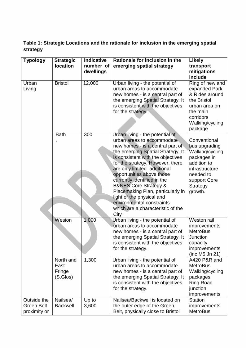
Table 1: Strategic Locations and the rationale for inclusion in the emerging spatial strategy
Typology Strategic
location Indicative number of dwellings
Rationale for inclusion in the emerging spatial strategy
Likely transport mitigations include
Urban Living
Bristol 12,000 Urban living - the potential of urban areas to accommodate new homes - is a central part of the emerging Spatial Strategy. It is consistent with the objectives for the strategy.
Ring of new and expanded Park & Rides around the Bristol urban area on the main corridors Walking/cycling package
Bath .
300 Urban living - the potential of urban areas to accommodate new homes - is a central part of the emerging Spatial Strategy. It is consistent with the objectives for the strategy. However, there are only limited additional opportunities above those currently identified in the B&NES Core Strategy & Placemaking Plan, particularly in light of the physical and environmental constraints which are a characteristic of the City
Conventional bus upgrading Walking/cycling packages in addition to infrastructure needed to support Core Strategy growth.
Weston 1,000 Urban living - the potential of urban areas to accommodate new homes - is a central part of the emerging Spatial Strategy. It is consistent with the objectives for the strategy.
Weston rail improvements MetroBus Junction capacity improvements (inc M5 Jn 21)
North and East Fringe (S.Glos)
1,300 Urban living - the potential of urban areas to accommodate new homes - is a central part of the emerging Spatial Strategy. It is consistent with the objectives for the strategy.
A420 P&R and MetroBus Walking/cycling packages Ring Road junction improvements
Outside the Green Belt proximity or
Nailsea/ Backwell
Up to 3,600
Nailsea/Backwell is located on the outer edge of the Green Belt, physically close to Bristol
Station improvements MetroBus
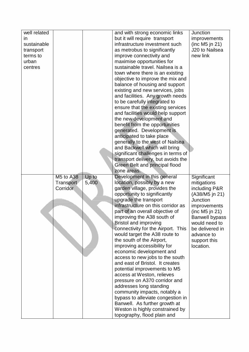
well related in sustainable transport terms to urban centres
M5 to A38 Transport Corridor
Up to 5,400
and with strong economic links but it will require transport infrastructure investment such as metrobus to significantly improve connectivity and maximise opportunities for sustainable travel. Nailsea is a town where there is an existing objective to improve the mix and balance of housing and support existing and new services, jobs and facilities. Any growth needs to be carefully integrated to ensure that the existing services and facilities would help support the new development and benefit from the opportunities generated. Development is anticipated to take place generally to the west of Nailsea and Backwell which will bring significant challenges in terms of transport delivery, but avoids the Green Belt and principal flood zone areas. Development in this general location, possibly by a new garden village, provides the opportunity to significantly upgrade the transport infrastructure on this corridor as part of an overall objective of improving the A38 south of Bristol and improving connectivity for the Airport. This would target the A38 route to the south of the Airport, improving accessibility for economic development and access to new jobs to the south and east of Bristol. It creates potential improvements to M5 access at Weston, relieves pressure on A370 corridor and addresses long standing community impacts, notably a bypass to alleviate congestion in Banwell. As further growth at Weston is highly constrained by topography, flood plain and
Junction improvements (inc M5 jn 21) J20 to Nailsea new link Significant mitigations including P&R (A38/M5 jn 21) Junction improvements (inc M5 jn 21) Banwell bypass would need to be delivered in advance to support this location.
significant highway capacity issues, this provides an opportunity to provide future growth to meet Weston’s needs, linked to the existing urban area by transport improvements.
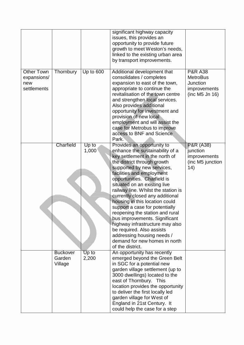
Other Town expansions/ new settlements
Thornbury Up to 600 Additional development that consolidates / completes expansion to east of the town, appropriate to continue the revitalisation of the town centre and strengthen local services. Also provides additional opportunity for investment and provision of new local employment and will assist the case for Metrobus to improve access to BNF and Science Park.
P&R A38 MetroBus Junction improvements (inc M5 Jn 16)
Charfield Up to 1,000
Provides an opportunity to enhance the sustainability of a key settlement in the north of the district through growth supported by new services, facilities and employment opportunities. Charfield is situated on an existing live railway line. W hilst the station is currently closed any additional housing in this location could support a case for potentially reopening the station and rural bus improvements. Significant highway infrastructure may also be required. Also assists addressing housing needs / demand for new homes in north of the district.
P&R (A38) junction improvements (inc M5 junction 14)
Buckover Garden Village
Up to 2,200
An opportunity has recently emerged beyond the Green Belt in SGC for a potential new garden village settlement (up to 3000 dwellings) located to the east of Thornbury. This location provides the opportunity to deliver the first locally led garden village for West of England in 21st Century. It could help the case for a step

Locations within or partially within the Green Belt
SE Bristol Whitchurch
Up to 3,500
change in public transport to the locality, linking to Metrobus routes to enable access to the major employment centres of North Bristol. Significant highway infrastructure, including the strategic road network (M5) may also be required. It also potentially broadens the housing supply models in the sub-region via a single ownership with genuinely visionary approach to place making and land value capture. Alongside planned expansion at Charfield it would also provide the opportunity for the local communities in the north of the district to meet housing pressures in a planned sustainable way. Buckover is also a potential growth point for any future Oldbury NNB. Land south and east of Whitchurch Village performs relatively well in the sustainability appraisal because of its proximity to Bristol, and the choice of travel options available in this location. However, this location is only deliverable if substantial new sub-regional and local transport infrastructure is provided, focussing on public transport, including conventional bus service upgrading, new park & ride, and future Metrobus or rapid transit provision. Additional highways capacity would also be needed, to address underlying congestion issues, to provide access to new development and to release space for the public transport improvements. Housing capacity is constrained to about 3,500 dwellings to avoid causing unacceptable harm to nationally important heritage assets as well as retaining the Green Belt separation of Whitchurch Village
Walking & cycling package Conventional bus upgrading A37 new Park & Ride Orbital Metrobus linking Whitchurch/Hick s Gate/city centre A4-A37 new or improved orbital links (also facilitates Metrobus corridor) Whitchurch distributor road including connection to A4-A37
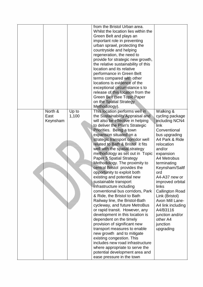
North & East Keynsham
Up to 1,100
from the Bristol Urban area. Whilst the location lies within the Green Belt and plays an important role in preventing urban sprawl, protecting the countryside and helping regeneration, the need to provide for strategic new growth, the relative sustainability of this location and its relative performance in Green Belt terms compared with other locations is evidence of the exceptional circumstance s to release of this location from the Green Belt (see Topic Paper on the Spatial Strategy Methodology). This location performs well in the Sustainability Appraisal and will also be effective in helping to deliver the Plan's Strategic Priorities. Being a town expansion situated on a strategic transport corridor well related to Bath & Bristol it fits well with the spatial strategy methodology as set out in Topic Paper 5 Spatial Strategy Methodology. The proximity to central Bristol provides the opportunity to exploit both existing and potential new sustainable transport infrastructure including conventional bus corridors, Park & Ride, the Bristol to Bath Railway line, the Bristol-Bath cycleway, and future MetroBus or rapid transit. However, any development in this location is dependent on the timely provision of significant new transport measures to enable new growth and to mitigate existing congestion. This includes new road infrastructure where appropriate to serve the potential development area and ease pressure in the town
Walking & cycling package including NCN4 link Conventional bus upgrading A4 Park & Ride relocation and/or expansion A4 Metrobus terminating Keynsham/Saltf ord A4-A37 new or improved orbital links Callington Road Link (Bristol) Avon Mill Lane- A4 link including A4/B3116 junction and/or other A4 junction upgrading
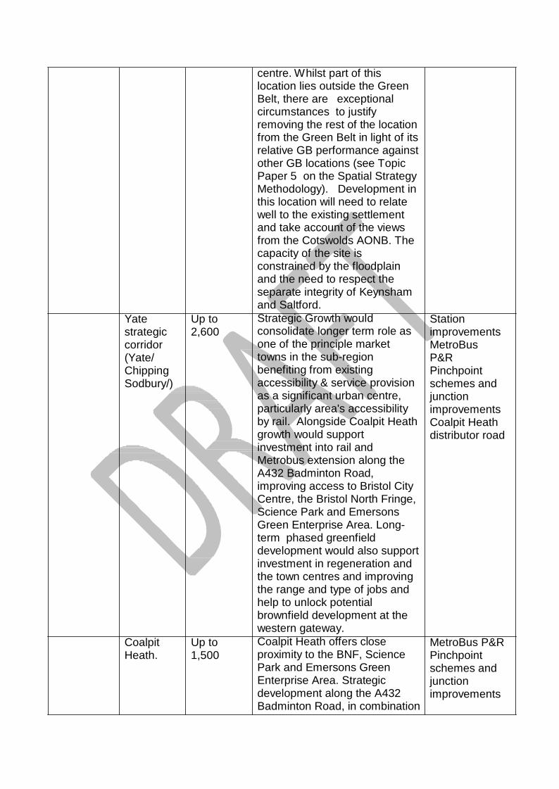
Yate strategic corridor (Yate/ Chipping Sodbury/)
Coalpit Heath.
Up to 2,600 Up to 1,500
centre. Whilst part of this location lies outside the Green Belt, there are exceptional circumstances to justify removing the rest of the location from the Green Belt in light of its relative GB performance against other GB locations (see Topic Paper 5 on the Spatial Strategy Methodology). Development in this location will need to relate well to the existing settlement and take account of the views from the Cotswolds AONB. The capacity of the site is constrained by the floodplain and the need to respect the separate integrity of Keynsham and Saltford. Strategic Growth would consolidate longer term role as one of the principle market towns in the sub-region benefiting from existing accessibility & service provision as a significant urban centre, particularly area's accessibility by rail. Alongside Coalpit Heath growth would support investment into rail and Metrobus extension along the A432 Badminton Road, improving access to Bristol City Centre, the Bristol North Fringe, Science Park and Emersons Green Enterprise Area. Long- term phased greenfield development would also support investment in regeneration and the town centres and improving the range and type of jobs and help to unlock potential brownfield development at the western gateway. Coalpit Heath offers close proximity to the BNF, Science Park and Emersons Green Enterprise Area. Strategic development along the A432 Badminton Road, in combination
Station improvements MetroBus P&R Pinchpoint schemes and junction improvements Coalpit Heath distributor road MetroBus P&R Pinchpoint schemes and junction improvements
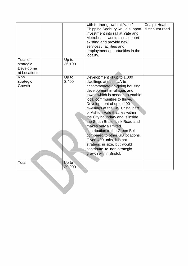
Total of strategic Developme nt Locations Non strategic Growth
Up to 36,100 Up to 3,400
with further growth at Yate / Chipping Sodbury would support investment into rail at Yate and Metrobus. It would also support existing and provide new services / facilities and employment opportunities in the locality. Development of up to 1,000 dwellings at each UA to accommodate on-going housing development in villages and towns which is needed to enable local communities to thrive. Development of up to 400 dwellings at the SW Bristol part of Ashton Vale that lies within the City boundary and is inside the South Bristol Link Road and makes only a limited contribution to the Green Belt compared to other GB locations. Given 400 units, it is not strategic in size, but would contribute to non-strategic growth within Bristol.
Coalpit Heath distributor road
Total Up to
39,900
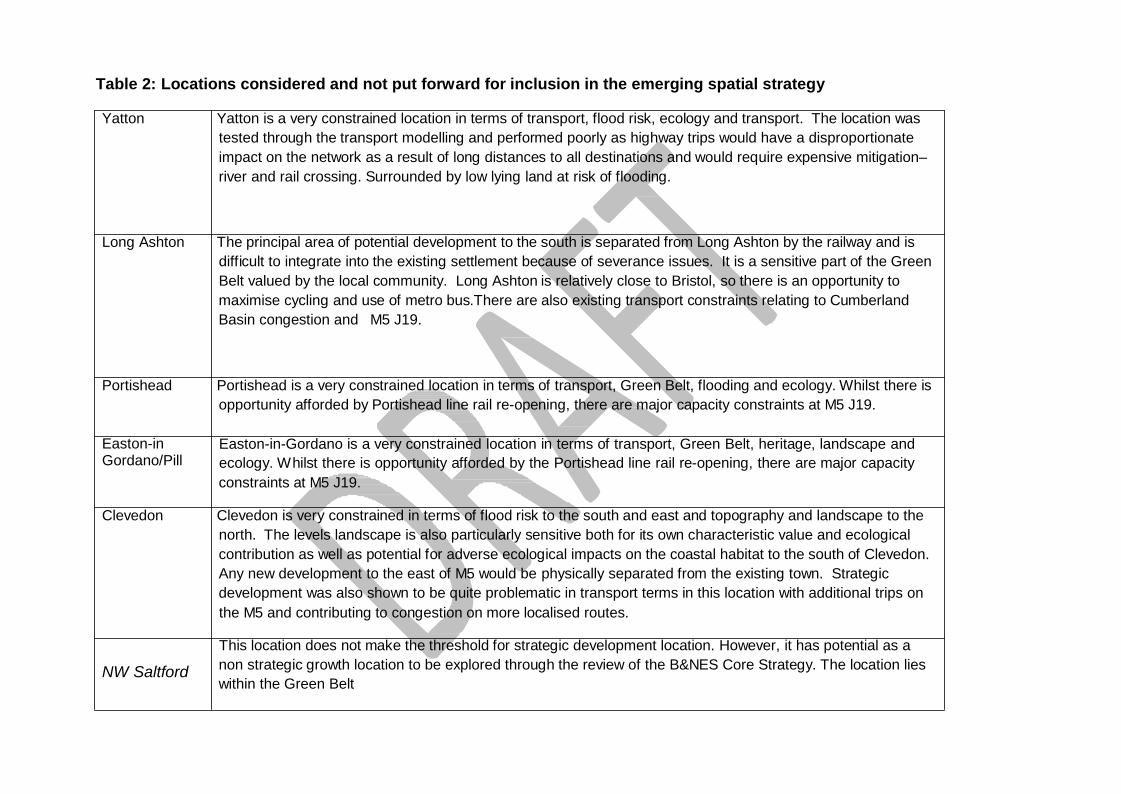
Table 2: Locations considered and not put forward for inclusion in the emerging spatial strategy
Yatton Yatton is a very constrained location in terms of transport, flood risk, ecology and transport. The location was tested through the transport modelling and performed poorly as highway trips would have a disproportionate impact on the network as a result of long distances to all destinations and would require expensive mitigation– river and rail crossing. Surrounded by low lying land at risk of flooding.
Long Ashton The principal area of potential development to the south is separated from Long Ashton by the railway and is difficult to integrate into the existing settlement because of severance issues. It is a sensitive part of the Green Belt valued by the local community. Long Ashton is relatively close to Bristol, so there is an opportunity to maximise cycling and use of metro bus.There are also existing transport constraints relating to Cumberland Basin congestion and M5 J19.
Portishead Portishead is a very constrained location in terms of transport, Green Belt, flooding and ecology. Whilst there is opportunity afforded by Portishead line rail re-opening, there are major capacity constraints at M5 J19.
Easton-in Gordano/Pill
Easton-in-Gordano is a very constrained location in terms of transport, Green Belt, heritage, landscape and ecology. Whilst there is opportunity afforded by the Portishead line rail re-opening, there are major capacity constraints at M5 J19.
Clevedon Clevedon is very constrained in terms of flood risk to the south and east and topography and landscape to the
north. The levels landscape is also particularly sensitive both for its own characteristic value and ecological contribution as well as potential for adverse ecological impacts on the coastal habitat to the south of Clevedon. Any new development to the east of M5 would be physically separated from the existing town. Strategic development was also shown to be quite problematic in transport terms in this location with additional trips on the M5 and contributing to congestion on more localised routes.
NW Saltford
This location does not make the threshold for strategic development location. However, it has potential as a non strategic growth location to be explored through the review of the B&NES Core Strategy. The location lies within the Green Belt
West & South West Keynsham
SE Keynsham
This location does not perform well in the Sustainability Appraisal. It would be difficult and costly to mitigate the negative impacts of development in this location. The location lies within the Green Belt This location does not perform well in the Sustainability Appraisal. It would be difficult and costly to mitigate the negative impacts of development in this location. The location lies within the Green Belt
SW Saltford
This location does not perform well in the Sustainability Appraisal. It would be difficult and costly to mitigate the negative impacts of development in this location. The location lies within the Green Belt
Somer Valley
The Somer Valley is one of the least sustainable locations in the sub-region for accommodating strategic housing growth. There is already a substantial imbalance in the number of workers who reside in the town and the employment available and this will be exacerbated in light of existing residential commitments. It has also proved difficult to attract new employment to the area and jobs have been steadily eroded over recent years. Therefore, strategic new housing growth will inevitably lead to substantial out commuting. Transport modelling shows that seeking to mitigate this will be difficult, costly and only partially effective. The purpose of the new Enterprise Zone is to facilitate employment generation to help mitigate the existing high levels of out- commuting.
Clutton and Temple Cloud
Sites in Clutton & Temple Cloud do not perform well as sustainable locations for accommodating strategic housing growth in the sub-region. The majority of new residents are highly likely to seek to travel by car to work and other activities. Transport modelling shows that seeking to mitigate this will be difficult, costly and only partially effective.
West of Twerton, Bath
Based on the SA the significance impact that development of this scale and this location would have on World Heritage site and its setting has led to this full site not being considered as a reasonable option. The severity of harm caused by development in this location would significantly outweigh the benefits. It would cause significant harm to the setting of the WHS and whilst it is not in the AONB, it is on the edge of Bath and is visually prominent, thereby causing harm to the AONB. As such development would contradict national policy. It also performs very strongly in Green Belt terms. Therefore this location is not suitable for development in the plan period.
SE Bristol Hicks Gate
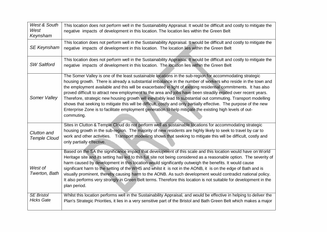
Whilst this location performs well in the Sustainability Appraisal, and would be effective in helping to deliver the Plan's Strategic Priorities, it lies in a very sensitive part of the Bristol and Bath Green Belt which makes a major
contribution to preventing the merger of Bristol and Keynsham. Ashton Vale The Green Belt at Ashton Vale (outside the South Bristol Link) makes a major contribution to Green Belt
purposes. It is an area of attractive countryside and a sensitive landscape in relation to, in particular, Ashton Court and Dundry Hill and has ecological importance. It provides the landscape setting to Bristol and for rural communities within North Somerset and plays a significant role in protecting the countryside from encroachment of development. Protecting high quality environment is a priority of the plan. The location was tested through the transport modelling and performed well in terms of potential accessibility by non-car modes given its proximity to Bristol. There are also existing transport constraints relating to M5 J19.
Kingswood/ Warmley
Some 13,500 dwellings also remain to be constructed on land allocated in the South Gloucestershire Local Plan & Core Strategy across the Bristol North & North East Fringe communities over the next 10-15 years. Further strategic growth in the locality is likely to undermine delivery of these key sites. Moreover Bristol has historically predominantly grown north & eastwards. Strategic growth in the locality towards and also up the escarpments would significantly add to the impression of sprawl undermining the objectives of the Greenbelt. Notwithstanding this, significant growth will severely exacerbate congestion and air quality issues along the A420 corridor into Bristol. Road space along the A420 is significantly constrained by the nature of built form limiting the potential for necessary substantive strategic public transport, walking and cycling interventions along it. The locality is also poorly related to major areas of employment. Strategic growth would also further divorce existing communities to the west from physical and visual access to the countryside and potentially impact on Siston Conservation Area, Siston Lane and Webbs Heath areas of landscape value as well as local ecological interests.
North of M4/M5 Some 13,500 dwellings also remain to be constructed on land allocated in the South Gloucestershire Local
Plan & Core Strategy across the Bristol North & North East Fringe communities over the next 10-15 years. Further strategic growth in the locality is likely to undermine delivery of these key sites. Moreover Bristol has historically predominantly grown north & eastwards. Strategic growth in the locality would also therefore significantly add to the impression of sprawl significantly undermining the objectives of the Greenbelt. Notwithstanding this, although the locality is in close proximity to existing strategic employment locations the location lacks good connections. Strategic growth would be severed from the existing urban area by the motorway therefore limiting options in terms of new connections. Strategic growth would therefore have a severe impact on Hortham village and J16 being in such close proximity. Strategic growth would also divorce existing communities from access to the countryside and maturing recreational opportunities, important to
support existing residential and employment areas in the north Bristol fringe. Pucklechurch & M4 to Shortwood
Some 13,500 dwellings also remain to be constructed on land allocated in the South Gloucestershire Local Plan & Core Strategy across the Bristol North & North East Fringe communities over the next 10-15 years. Further strategic growth in the locality is likely to undermine delivery of these key sites. Moreover similar to significant growth at Kingswood/Warmley, strategic growth will severely exacerbate congestion and air quality issues along radial routes into Bristol, where road space is significantly constrained by the nature of built form so limiting the potential for necessary substantive strategic public transport, walking and cycling interventions. The locality is also less well related to major areas of employment than proposed growth points at Yate & Coalpit Heath. Strategic growth would also further divorce existing communities from physical and visual access to the countryside and potentially impact on Siston Conservation Area. Development between Pucklechurch and the East Fringe is also highly constrained by its topography, ecological and archaeological interests. Significant development in the locality up these escarpments would thus significantly add to the impression of sprawl and separation in the locality undermining the objectives of the Greenbelt. Pucklechurch itself may have potential for some non-strategic growth to support local services. To be considered through the Local Plan process.
Olveston Olveston is surrounded by high quality landscape, ecological and heritage assets. Access is along ‘lanes’. This
village is not considered suitable for strategic level growth but may have potential for some non-strategic growth to support local services. To be considered through the Local Plan process.
Wickwar Major strategic growth is not considered appropriate due to areas of important landscape, heritage and
ecological value to the north, northwest and east. The village is also less well related to major areas of employment than proposed growth points at Yate & Coalpit Heath. Strategic growth would be car based with limited opportunity to improve public transport options, thereby also impacting on other settlements on route to higher order localities and the strategic transport network. However the village may have potential for some non-strategic growth to support local services. To be considered through the Local Plan process.
Alveston Major strategic growth is not considered appropriate due to areas of particular landscape and heritage value to
the north, northeast and west. The A38 would sever development to the southeast from the village. Development to the north would also compromise separation from Thornbury undermining green belt objectives. The settlement / locality is therefore not considered suitable for strategic level growth but may have potential for some non-strategic growth to support local services. To be considered through the Local Plan
process. Almondsbury Some 13,500 dwellings also remain to be constructed on land allocated in the South Gloucestershire Local Plan
& Core Strategy across the Bristol North & North East Fringe communities over the next 10-15 years. Further strategic growth in the locality is likely to undermine delivery of these key sites. Moreover major strategic growth is not considered appropriate due to the village being constrained by noise, pylons, solar park and proposed air ambulance site to its south / southeast and high landscape value / slopes towards the Severn Vale to its northwest. Similar to land north of M4/M5, strategic growth would also have a severe impact on Hortham village and J16, being in such close proximity. Bristol has also historically predominantly grown north & eastwards. Strategic growth would thus also significantly add to the impression of sprawl in the locality significantly undermining the objectives of the Greenbelt. Therefore, the settlement/locality is not considered suitable for strategic level growth but may have potential for some non-strategic growth to support local services. To be considered through the Local Plan process.
Longwell Green Land at Longwell Green essentially comprises slopes and hilltop with Hanham Abbots Conservation area to
the south. This area is an important physical and visual asset with extensive views to and from it to surrounding urban areas. Strategic growth over this area would significantly add to the impression of sprawl undermining objectives of the greenbelt.
Hambrook Some 13,500 dwellings also remain to be constructed on land allocated in the South Gloucestershire Local
Plan & Core Strategy across the Bristol North & North East Fringe communities over the next 10-15 years. Further strategic growth in the locality is likely to undermine delivery of these key sites. Moreover the area is located between the M4 motorway and ring road, severing it from existing communities and suffering from noise and fumes. Hambrook village is also a conservation area with a number of heritage assets. The settlement / locality is therefore not considered suitable for strategic level growth but may have potential for some limited non-strategic growth to support local services. To be considered through the Local Plan process.
Bridge Yate / Oldland Common
The locality is characterised by the escarpment and ridgeline running along its length forming the ‘natural’ edge to the Bristol urban area. A pylon, abattoir and conservation area, archaeological and ecological interests are also present. The escarpments and ridgelines that frame / contain this part of Bristol East Fringe also protect the setting of the AONB. Bristol has also historically predominantly grown north & eastwards. Significant development in the locality up these escarpments would thus significantly add to the impression of sprawl in the locality undermining the objectives of the Greenbelt. Strategic growth would also further divorce existing
communities from physical and visual access to the countryside. Therefore, this locality is not considered suitable for strategic level growth but may have potential for some non-strategic growth to support local services. To be considered through the Local Plan process.
Severnside Comprising Severnside employment areas, Severn Beach, Pilning and Easter Compton. The locality is
characterised by the Severn Estuary and the Vale hinterland. With the exception of Easter Compton the locality is predominantly flood zone 3 and provides important habitats for birdlife and other wildlife (designations comprise RAMSAR, SPA, SAC & SSSIs). Strategic pylons and pipelines also intersect the locality. The Severnside 1957/58 employment consent covers much of the area and remains to be completely built out. Therefore, the locality is not considered suitable for strategic level residential growth but may have potential for some limited non-strategic growth to support local services. To be considered through the Local Plan process.
Likely mitigations and infrastructure required to support the emerging spatial strategy
50. Our transport network has an increasing volume of travel and complex travel
patterns. This has contributed to a network that is often at capacity at peak times, with increased journey times and congestion. These impacts have been perceived as a barrier to securing sustainable economic growth. This threatens not only the productivity of our businesses and workforce but our ability to meet wider sustainable objectives such as reducing carbon emissions and improving air quality in our urban areas.
51. Transport investment can be a major influence on where development is located and
how to create high quality places in which people want to live and work. Influencing the location of development will not of itself be sufficient to address the issue.
52. Integrating housing and employment development with investment in reliable, high quality transport choices will reduce the length and number of journeys to work, encourage more sustainable travel modes such as cycling, walking and public transport and reduce the reliance on car based journeys.
53. To support the additional development required as a result of the spatial strategy the
approach to infrastructure provision seeks to:
• maximise the effectiveness of sustainable travel choices and encourage mode shift (to rail, MetroBus, Park & Ride, bus, cycling, walking) across the plan area.
• maximise the effectiveness of non-car mode choices for both urban living and new development outside existing urban areas;
• then, mitigate impacts of additional traffic, including investigation of junction capacity improvements, upgrades, new highway connections and traffic restrictions.
Encouraging mode shift across the plan area:
54. MetroBus will be central to delivering mode shift at strategic development locations,
and along key corridors with a number of locations outside of walking/cycling distance from key attractors and less-well served by the conventional bus and rail networks;
55. –A network of new Park & Ride and interchange schemes will help to intercept trips on the edge of Bristol and Bath urban areas: reduce traffic in Bristol and Bath and improve conditions for walking, cycling and public transport;
56. Conventional local bus services and in particular improving existing bus
services will be an important part of promoting sustainable travel on several corridors;
57. Rail will play an important role for access to urban centres, but improvements will be needed (capacity, access to stations, parking, station environment, interchanges ) and it should be recognised that with a modest modal share, 2.1% of journeys to work in the 2011 Census, and despite impressive levels of passenger growth in recent years rail is just part of a wider package of transport measures. Some locations will remain difficult to serve by rail;
58. Walking and cycling must take a central role for shorter trips –better links to
surrounding walking and cycling networks are assumed; Supporting infrastructure for urban living:
59. There are limited opportunities for significant highway capacity improvements in the Bristol urban areas. Intensification will require a different approach to reduce traffic to create conditions for urban growth. This will:
• necessitate more walking, cycling and public transport within the urban areas. • require intercepting traffic on radial routes into Bristol with Park & Ride, and other
interchanges • locate development around transit hubs, • require re-allocating road-space to better promote sustainable travel choices on
radial routes, potentially facilitated by improvements to orbital highway capacity in certain locations.
60. Consultation on the Joint Transport Study will take place concurrently with the
JSP consultation. Information about both the JSP and JTS consultation can be found at https://www.jointplanningwofe.org.uk/

Strategic Transport Improvement
Urban Living
Figure 5: JSP Spatial Strategy Map: new development locations (incl employment locations).
Green Belt
Strategic Employment Location
Buckover Thornbury
Charfield
Strategic Development Locations
Motorway Council Boundary Railway line A Road Port
Bristol
Yate/Chipping Sodbury Coalpit Heath
Nailsea
Backwell Keynsham
Weston-super-Mare Airport Whitchurch Bath
M5-A38 Corridor
Somer Valley
Note: Locations symbols are illustrative only and must not be taken to imply any specific development sites.
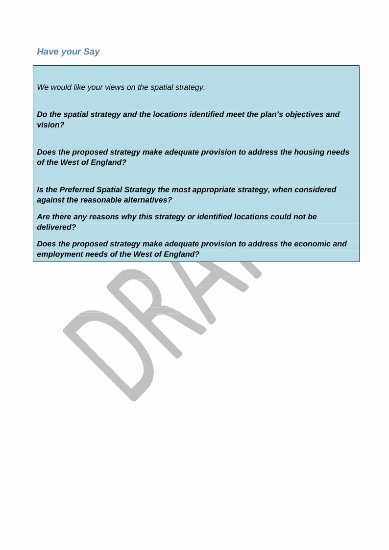
Have your Say We would like your views on the spatial strategy.
Do the spatial strategy and the locations identified meet the plan’s objectives and vision?
Does the proposed strategy make adequate provision to address the housing needs of the West of England?
Is the Preferred Spatial Strategy the most appropriate strategy, when considered against the reasonable alternatives?
Are there any reasons why this strategy or identified locations could not be delivered?
Does the proposed strategy make adequate provision to address the economic and employment needs of the West of England?

33