Embed Size (px)
Citation preview
8102019 Articulo - Geomorphology Natural Hazards Vulnerability and Prevention of Natural Disasters in Developing Countrihellip
httpslidepdfcomreaderfullarticulo-geomorphology-natural-hazards-vulnerability-and-prevention-of 118
Geomorphology natural hazards vulnerability and prevention
of natural disasters in developing countries
Irasema Alcantara-Ayala
Department of Civil and Environmental Engineering Massachusetts Institute of Technology
Room 1-330 77 Massachusetts Avenue Cambridge MA 02139-4307 USA
Received 20 September 1999 received in revised form 27 November 2000 accepted 25 October 2001
Abstract
The significance of the prevention of natural disasters is made evident by the commemoration of the I nternational Decade
for N atural Disaster Reduction (IDNDR) This paper focuses on the role of geomorphology in the prevention of natural disasters
in developing countries where their impact has devastating consequences Concepts such as natural hazards natural disasters
and vulnerability have a broad range of definitions however the most significant elements are associated with the vulnerability
concept The latter is further explored and considered as a key factor in understanding the occurrence of natural disasters and
consequently in developing and applying adequate strategies for prevention Terms such as natural and human vulnerabilities
are introduce and explained as target aspects to be taken into account in the reduction of vulnerability and for prevention and
mitigation of natural disasters The importance of the incorporation not only of geomorphological research but also of geomorphologists in risk assessment and management programs in the poorest countries is emphasized
D 2002 Elsevier Science BV All rights reserved
Keywords Geomorphology Natural hazards Natural disasters Vulnerability Prevention Developing countries
1 Introduction
Before the appearance of Homo sapiens on Earth
the purely natural system ruled our planet Manygeophysical events such as earthquakes volcanic
eruptions landsliding andor flooding took place
threatening only the prevailing flora and fauna Mil-
lions of years later the human presence transformed
the geophysical events into natural disasters
The transformation of these geophysical events
into natural disasters occurred simultaneously with
the appearance of the human system when human
beings began to interact with nature when fire wasdiscovered and tools were made from the offerings of
the natural habitats The evolution of humans left
behind the age in which only nature existed It
provided the starting point of the interrelation of the
human system with nature
The human system itself was subjected to signifi-
cant transformations where the concept of work and
hence of social division of work production relations
and economical ndash political systems appeared These
transformations and their links to the natural system
0169-555X02$ - see front matter D 2002 Elsevier Science BV All rights reservedP I I S 0 1 6 9 - 5 5 5 X ( 0 2 ) 0 0 0 8 3 - 1
Fax +1-525-56-16-21-45
E-mail address irasemaigirisigeografunammx
(I Alcantara-Ayala)
wwwelseviercomlocategeomorph
Geomorphology 47 (2002) 107ndash124
8102019 Articulo - Geomorphology Natural Hazards Vulnerability and Prevention of Natural Disasters in Developing Countrihellip
httpslidepdfcomreaderfullarticulo-geomorphology-natural-hazards-vulnerability-and-prevention-of 218
have served as templates of the dynamics of natural
hazards and therefore of natural disasters
Natural hazards are indeed geophysical events
such as earthquakes landsliding volcanic activityand flooding They have the characteristic of posing
danger to the different social entities of our planet
nevertheless this danger is not only the result of the
process per se (natural vulnerability) it is the result of
the human systems and their associated vulnerabilities
towards them (human vulnerability) When both types
of vulnerability have the same coordinates in space
and time natural disasters can occur
Natural disasters occur worldwide however their
impact is greater in developing countries where they
occur very often In most cases the occurrence of
natural disasters in these countries is due to two main
factors First there is a relation with geographical
location and geologicalndash geomorphological settings
Developing or poor countries are located to a great
extent in zones largely affected by volcanic activity
seismicity flooding etc The second reason is linked
to the historical development of these poor countries
where the economic social political and cultural
conditions are not good and consequently act as
factors of high vulnerability to natural disasters (eco-
nomic social political and cultural vulnerability)
Recently attention has been paid to the preventionreduction and mitigation of natural disasters by creat-
ing a Scientific and Technical Committee of the Inter-
national Decade for Natural Disaster Reduction
(IDNDR) Efforts within this international framework
have been taken worldwide however since natural
disasters continue to devastate developing countries
(eg Hurricane Mitch in Central America) a major
emphasis on prevention should be addressed [or under-
taken] by institutions at all levels namely international
national regional local etc Strategies for prevention
of natural disasters are universal yet their applicabilityneeds to take into account the particular characteristics
of the threatened entity in such a way that a better
understanding of the vulnerability of a specified social
entity (natural + human) could lead to the development
of adequate disaster prevention strategies
Understanding and reducing vulnerability is
undoubtedly the task of multi-disciplinary teams
Amongst geoscientists geomorphologists with a
geography background might be best equipped to
undertake research related to the prevention of natural
disasters given the understanding not only of the
natural processes but also of their interactions with
the human system In this sense geomorphology has
contributed enormously to the understanding andassessment of different natural hazards (such as flood-
ing landslides volcanic activity and seismicity) and
to a lesser extent geomorphologists have started
moving into the natural disaster field
This paper addresses the significance of the incor-
por ati on of geomo rph ologists into the nat ional
regionallocal groups of experts to establish adequate
strategies of risk assessment and management These
strategies should be based on an understanding of the
necessities derived from the vulnerability both natural
and human of the threatened social entities Given the
existence of differential vulnerabilities this task is
even more relevant in developing countries located in
areas prone to natural hazards and where the character
of marginalization and economical political social
and cultural issues reduce the opportunities to prevent
and cope with natural disasters
2 Natural hazards and geomorphology
The term natural hazard implies the occurrence of a
natural condition or phenomenon which threatens or acts hazardously in a defined space and time Different
conceptualizations of natural hazards have not only
evolved in time they also reflect the approach of the
different disciplines involved in their study In this
sense a natural hazard has been expressed as the
elements in the physical environment harmful to man
(Burton and Kates 1964) an interaction of people and
nature (White 1973) the probability of occurrence of a
potentially damaging phenomenon (UNDRO 1982)
and as a physical event which makes an impact on hu-
man beings and their environment (Alexander 1993) Natural hazards are threatening events capable of
producing damage to the physical and social space
where they take place not only at the moment of their
occurrence but on a long-term basis due to their
associated consequences When these consequences
have a major impact on society andor infrastructure
they become natural disasters
The term hazard is often associated with different
agents or processes Some of those include atmos-
pheric hydrologic geologic biologic and techno-
I Alca ntara-Ayala Geomorphology 47 (2002) 107ndash124108
8102019 Articulo - Geomorphology Natural Hazards Vulnerability and Prevention of Natural Disasters in Developing Countrihellip
httpslidepdfcomreaderfullarticulo-geomorphology-natural-hazards-vulnerability-and-prevention-of 318
logic Specifically natural hazards are considered
within a geological and hydrometeorological concep-
tion where earthquakes volcanoes floods landslides
storms droughts and tsunamis are the main typesThese hazards are strongly related to geomorphology
since they are important ingredients of the Earthrsquos
surface dynamics Hazards are the result of sudden
changes in long-term behavior caused by minute
changes in the initial conditions (Scheidegger
1994) In this sense geomorphic hazards can be
categorized as endogenous (volcanism and neotecton-
ics) exogenous (floods karst collapse snow ava-
lanche channel erosion sedimentation mass
movement tsunamis coastal erosion) and those
induced by climate and land-use change (desertifica-
tion permafr ost degradation soil erosion saliniza-
tion floods) (Slaymaker 1996)
According to Gares et al (1994) geomorphic
hazards can be regarded as the group of threats to
human resources resulting from the instability of the
Earthrsquos surface features The importance of these
features is concentrated on the response of the land-
forms to the processes rather than on their original
source Notwithstanding the lack of the use of the
concept geomorphic hazard (Gares et al 1994 Slay-
maker 1996) geomorphology has an important task
to fulfill in terms of natural hazards research Magni-tude and frequency as well as temporal and spatial
scale are key geomorphic concepts strongly corre-
lated to natural hazards
Indeed many contributions by geomorphologists
or within the geomorphology field have been directed
towards the analysis and understanding of natural
hazards Based on their observations of fluvial pro-
cesses Wolman and Miller (1960) introduced the
importance of magnitude and frequency of different
events and their significance on the landscape as a
result of the total work performed by them Thereforethe importance of both extreme events and high-
frequency low-magnitude events within geomorphic
processes is determined by the relation of the work
done on the landscape to the particular landforms
resulting from it For a given event such as a natural
hazard magnitude and frequency exert a very impor-
tant control on the impact of geomorphic processes
since they have an influence on landform change and
therefore on the dynamic equilibrium in geomorpho-
logical systems
The concepts of magnitude and frequency are
essential for the assessment of natural hazards For
example the consequences of a flood are measured
using return periods giving an idea of the character-istics the flood may have (magnitude) and how often
it is likely to occur (frequency) Although flooding
can be regarded as the typical example to represent the
magnitude and frequency duality it also can be well
typified by processes such as mass movement vol-
canic activity neotectonics and erosion For instance
the significance of magnitude and frequency on mass
movement has been demonstrated by the occurrence
of slope failures under different conditions and on a
great variety of materials These events included
storms with 50 years of recurrence intervals in Scot-
land (Jenkins et al 1988) winter floods and their
associated failures in humid temperate catchments
(Dowdeswell et al 1988) in the Pyrenees (Coromi-
nas and Moya 1996) in Mediterranean environments
(Montgomery and Dietrich 1994 Thornes and Alcan-
tara-Ayala 1998) and in Colombia (Terlien 1996) to
mention a few
The dynamism of the Earthrsquos surface is enclosed
within a temporal and spatial scale The response of
the landform to the changes caused by the processes
corresponds to the magnitude and frequency of the
events the resistance of the involved materials and thesize of the concerned landform (Summerfield 1991)
Natural hazards take place in a certain place and
during a specific time but their occurrence is not
instantaneous Time is always involved in the devel-
opment of such phenomena For example flooding
triggered by hurricanes or tropical storms is developed
on a time basis Atmospheric perturbations lead to the
formation of tropical storms which may evolve into
hurricanes taking from a few hours to some days
Hence the intensity and duration of rainfall in con-
junction with the nature of the fluvial system devel-oped also on a time basis would determine the
characteristics of the flooding
3 Natural disasters
31 Defining natural disasters
Several definitions of natural disasters emphasize
the character of this term During the 1960s disasters
I Alca ntara-Ayala Geomorphology 47 (2002) 107ndash124 109
8102019 Articulo - Geomorphology Natural Hazards Vulnerability and Prevention of Natural Disasters in Developing Countrihellip
httpslidepdfcomreaderfullarticulo-geomorphology-natural-hazards-vulnerability-and-prevention-of 418
were understood as uncontrollable events in which a
society undergoes severe danger disrupting all or
some of the essential functions of the society (Fritz
1961) The idea of a defenseless society clearly
damaged by a powerful natural force is expressed in
a definition where a disaster is a severe sudden and
frequently disruption of normal structural arrange-ments within a social system over which the social
system has no control (Barkun 1974)
Westgate and OrsquoKeefe (1976) were among the first
to recognize the importance of vulnerability by defin-
ing disaster as the interaction between extreme phys-
ical or natural phenomena and a vulnerable human
group resulting in general disruption and destruction
loss of life and livelihood and injury IDNDR (1992)
defined a disaster as lsquolsquoa serious disruption of thefunctioning of a society causing widespread human
material or environmental losses which exceed the
Fig 1 Number of disasters and associated damage worldwide between 1900 and 1999 (Source EM-DAT database)
Fig 2 People killed and affected as a result of the natural disasters occurring in the world between 1950 and 1999 (Source EM-DAT database)
I Alca ntara-Ayala Geomorphology 47 (2002) 107ndash124110
8102019 Articulo - Geomorphology Natural Hazards Vulnerability and Prevention of Natural Disasters in Developing Countrihellip
httpslidepdfcomreaderfullarticulo-geomorphology-natural-hazards-vulnerability-and-prevention-of 518
Table 1
Some of the major geomorphology related natural disasters of the world from 1900 to 1999 (Data source EM-DAT and the Office of US
Foreign Disaster Assistance)
Disaster Year Country Killed Affected
Flood Jul-1931 Peoplersquos Republic of China 3700000 28500000
Flood Jul-1959 Peoplersquos Republic of China 2000000 ndash
Flood Oct-1949 Guatemala 40000 ndash
Floodmudslides Dec-1999 Venezuela 30000 600000
Flood Aug-1998 Peoplersquos Republic of China 3656 238973000
Flood 10-Aug-1998 India 1811 29227200
Flood 06-Aug-1998 Sudan 1393 338000
Flood 09-Sep-1998 Mexico 1256 400000
Flood 7-Jul-1993 India 827 128000000
Flood 28-Feb-1999 Mozambique 23 177000
Cyclone 18-Oct-1999 India 9465 15000000
Cyclone 2-Oct-1963 Grenada Trinidad y Tobago
Dominican Republic Haiti
Jamaica Cuba Bahamas
7258 ndash
Cyclone Nov-1964 Vietnam 7000 700000
Cyclone 3-Sep-1930 DominicaDominic Republic 6500 20000
Cyclone 8-Sep-1900 United States 6000 ndash
Cyclone (Mitch) 26-Oct-1998 Honduras 5657 2100000
Cyclone 09-Jun-1998 India 3000 4600000
Cyclone (Mitch) 26-Oct-1998 Nicaragua 2447 868000
Cyclone (Mitch) 26-Oct-1998 Guatemala 263 105700
Cyclone (Mitch) 26-Oct-1998 El Salvador 240 84000
Storm 25-Nov-1998 Bangladesh 200 121000
Earthquake 5-Oct-1948 Soviet Union 110000 ndash
Earthquake 28-Dec-1908 Italy 75000 150000
Earthquakedebris avalanche 31-May-1970 Peru 66794 3216240
Earthquake 6-Dec-1939 Turkey 32962 ndash
Earthquake 24-Jan-1939 Chile 30000 58500
Earthquake 13-Jan-1915 Italy 30000 ndash
Earthquake 4-Feb-1976 Guatemala 23000 4993000
Earthquake 17-Aug-1999 Turkey 15466 23954
Earthquake 21-Jan-1917 Indonesia 15000 ndash
Earthquake 28-Feb-1960 Morocco 12000 25000
Earthquake 23-Dec-1972 Nicaragua 10000 720000
Earthquake 21-Jan-1944 Argentina 10000 155000
Earthquake 19-Sep-1985 Mexico 8776 130204
Earthquake 16-Aug-1976 Philippines 6000 181348
Earthquake 29-Apr-1903 Turkey 6000 ndash
Earthquake 18-Feb-1951 Papua New Guinea 3000 ndash
Earthquake 26-Sep-1999 Taiwan 2084 100000
Earthquake 25-Jan-1999 Colombia 1171 745000Volcano 8-May-1902 Martinique 40000 ndash
Volcano 13-Nov-1985 Colombia 21800 12700
Volcano 1909 Indonesia 5500 ndash
Volcanomudflows 1919 Indonesia 5000 ndash
Volcano 15-Jan-1951 Papua New Guinea 3000 ndash
Volcano 21-Aug-1986 Cameroon 1734 4634
Avalanche 13-Dec-1916 ItalyAustria 10000 ndash
Tsunami 17-Jul-1998 Papua New Guinea 2182 9199
I Alca ntara-Ayala Geomorphology 47 (2002) 107ndash124 111
8102019 Articulo - Geomorphology Natural Hazards Vulnerability and Prevention of Natural Disasters in Developing Countrihellip
httpslidepdfcomreaderfullarticulo-geomorphology-natural-hazards-vulnerability-and-prevention-of 618
ability of affected society to cope using only its own
resources Disasters are often classified according to
their speed of onset (sudden or slow) or according to
their cause (natural or man-made)rsquorsquo
The dual character of natural disasters has been
addressed by considering not only the natural charac-
ter but also the social and economic systems As a
result a natural disaster can be defined as some rapid
instantaneous or profound impact of the natural envi-
ronment upon the socio-economic system (Alexander1993) or as a suddenly disequilibrium of the balance
between the forces released by the natural system and
the counteracting forces of the social system The
severity of such disequilibrium depends on the rela-
tion between the magnitude of the natural event and
the tolerance of human settlements to such an event
(Albala-Bertrand 1993) As explained by Tobin and
Montz (1997) a disaster is an event that has a big
impact on society It is a hazardous event that disrupts
the workings of society It may or may not lead to
deaths but it typically has severe economic impacts
By reviewing definitions of natural disasters it is
clear that there is a tendency to include either the
physical events as cause of the disaster or to acknowl-
Fig 3 Percentage of the number of disasters registered from 1900
until 1999 by regions of the world (Source EM-DAT database)
Fig 4 Occurrence of different types of disasters by regions of the globe Cylinder bars show the percentage of each particular disaster in a given
region in relation to the whole world (Source EM-DAT database)
I Alca ntara-Ayala Geomorphology 47 (2002) 107ndash124112
8102019 Articulo - Geomorphology Natural Hazards Vulnerability and Prevention of Natural Disasters in Developing Countrihellip
httpslidepdfcomreaderfullarticulo-geomorphology-natural-hazards-vulnerability-and-prevention-of 718
edge that the social and economic systems take part as
well as nature In some cases the possible consequen-
ces of the natural disasters are stated whereas the
reason why they occur is frequently omitted
32 Where do natural disasters occur
Natural disasters are a global issue as they occur all
over the world (Figs 1 and 2) Even though they may
have a considerable impact in countries such as Japan
USA France or Switzerland their significance in
countries such as Bangladesh India China Guate-
mala Colombia or Mexico is by far greater (Table 1)
The global death toll due to natural disasters is
concentrated in developing countries (also called
Third World Countries) and it can be as high as
95 of the total toll (Alexander 1993)
Most of the developing countries are located in
areas especially prone to natural hazards Volcanism is
associated with specific areas such as the Circum-
Pacific Volcanic Belt where approximately 80 of
the total activity takes place (Anderson and Decker
1992) Many Latin American and Asian countries are
located within this area and the effect volcanism and
its associated risks may cause to the population living
in close proximity is observed in disasters such as the
catastrophe of Nevado del Ruiz in Colombia (21800 people killed)
Asia and Latin America share the highest concen-
tration of flooding and associated risks due to hurri-
canes cyclones tropical storms typhoons and mon-
soons They are also the areas most susceptible to
earthquakes According to the registered natural dis-
asters which occurred between 1900 and 1999 (Fig 3)42 of the total number took place in Asia whereas
America had 27 Europe 13 and Oceania and
Africa 8 and 10 respectively (EM-DAT database
Office of US Foreign Disaster Assistance and the
Centre for Research on the Epidemiology of Disasters
OFDA CRED) The spatial distribution of natural dis-
asters (Fig 4) shows a clear tendency to occur in
developing countries In addition their impact is
reflected given the cost the consequences have in
relation to the GNP GDP and the time needed for
partial or total recovery For instance more than 9000
people lost their lives and about 11 (32 million
people) of the total population in Central America
was affected by the consequences of Hurricane Mitch
The impact was not homogeneous in all the countries
In Honduras the losses were equivalent to 80 of the
1997 GDP whereas those in Nicaragua were almost
49 of GDP The total losses of the whole region were
estimated at US$6 billion (Table 2) having a slightly
larger concentration of direct (515) than the indirect
(485) damage Furthermore the damage to the
population (Table 3) can be barely evaluated in finan-
cial t erms and in relation to the post-disaster recoverytime (CEPAL 1999)
The case of Hurricane Mitch in Central America
shows that even though the susceptibility of these
Table 2
Summary of damage in millions of dollars caused by Hurricane Mitch in Central America (Source CEPAL 1999 based on official figures and
their own estimates)
Total Direct damage Indirect damage Replacement cost
Total sectors 60183 31003 29180 44773
Social sectors 7985 5518 2466 9751
Housing 5909 4363 1546 7463
Health 1327 538 789 1170
Education 749 618 131 1118
Infrastructure 12455 6569 5886 17565
Roads bridges and railways 10695 5281 5415 14279
Energy 587 286 301 606
Water and sewerage systems 914 746 168 2244
Irrigation and drainage 258 256 02 436
Productive sectors 39069 18241 20828 16352
Farming fishing and forestry 29465 17019 12446 13020
Manufacturing industry 6080 328 5752 699
Trade restaurants and hotels 3524 894 2630 2633
Environment 674 674 00 1105
I Alca ntara-Ayala Geomorphology 47 (2002) 107ndash124 113
8102019 Articulo - Geomorphology Natural Hazards Vulnerability and Prevention of Natural Disasters in Developing Countrihellip
httpslidepdfcomreaderfullarticulo-geomorphology-natural-hazards-vulnerability-and-prevention-of 818
countries to natural disasters is high due to the
environmental setting (in a non-deterministic sense)
issues related to the social economic political and
cultural aspects of any social entity play a great role as
factors of vulnerability to natural disasters Although
poverty and natural disasters should not be considered
as synonyms it is certain that some characteristics
resulting from the economicndash socialndash politicalndash cul-
tural system reduce or eliminate equal access to
opportunities and therefore to development These
characteristics increase vulnerability Therefore the
occurrence of natural disasters in developing countries
is not only linked to the susceptibility of natural
hazards due to geologicalndashgeomorphological featuresand geographical location but also due to the vulner-
ability of the system where they exist
An example of the coupling of natural and
human vulnerability by analyzing the 1985 earth-
quake of Mexico City was presented by Blaikie et
al (1994) The city was erected on the bed of an
ancient lake making the soil highly vulnerable to
earthquakes and associated processes such as lique-
faction (natural vulnerability) Construction of build-
ings within the zone was performed using materials
of diverse type and quality during different periodsof time High population density low-income jobs
and poverty contributed to poor housing standards
(social and economic vulnerability) All the elements
derived from the particular natural social and
economic vulnerability of the area were combined
at the time of the earthquake producing zones of
disaster This case and the consequences of hurri-
cane Mitch underpin the need of both types of
vulnerability analysis to better understand and pre-
vent natural disasters
4 Natural disasters and geomorphology
Little has been done to associate geomorphology
and natural disasters directly Few publications in
geomorphology deal specifically with this issue (eg
Okuda 1970 Verstappen 1989 Rosenfeld 1994)
However innumerable works related to natural haz-
ards have represented the significance of geomorphol-
ogy to the natural disaster field Geomorphologists
have been concerned with the understanding analysis
and forecast of hazards such as flooding mass move-
ment earthquakes and volcanism
Flooding associated with hydrometeorological phe-
nomenon namely tropical storms hurricanes mon-soons (Kale et al 1994) El Nino or La Nina is
regarded as one of the most dangerous natural hazards
and principal trigger of disasters Fluvial geomorphol-
ogists have paid considerable attention to flooding
Approaches to understand this process include the
study of past events or palaeoflood geomorphology
and flood hydrology (Enzel et al 1993 Baker 1994
Kale et al 1997) Furthermore flood simulations
(Enzel and Wells 1997 Bates and De Roo 2000
Chang et al 2000) forecasting (Chowdhury 2000)
and flood maps elaborated by using GeographicalInformation Systems (GIS) (Merzi and Aktas 2000)
radar imagery (Zhou et al 2000) and remote sensing
(Islam and Sado 2000 Siegel and Gerth 2000) have
been a crucial aspect in the development of hazard and
risk assessment and management
Based on different approaches such as mapping
(Canuti et al 1987 Leroi 1997 Yin 1994) the
elaboration of inventories (Al-Homoud and Tubeileh
1997 Chacon et al 1996 Guzzetti et al 1994)
analysis of historical archives (Brunsden 1993 Ibsen
Table 3
Population affected by Hurricane Mitch in Central America (Source CEPAL 1999 based on official figures)
Item Total Costa Rica El Salvador Guatemala Honduras Nicaragua
(1) Dead 9214 4 240 268 5657 3045(2) Missing 9171 3 19 121 8058 970
(3) Injured 12842 ndash ndash 280 12275 287
(4) In shelters 466271 5411 55864 54725 285000 65271
(5) Total evacuated and direct victims 1191908 16500 84316 105000 617831 368261
(6) Population directly affected 3464662 20000 346910 730000 1500000 867752
(7) Children under five 1801624 10400 180393 379600 780000 451231
(8) Total population 31648907 3270700 6075536 11645900 6203188 4453583
(9) Percentage affected 109 06 57 63 242 195
I Alca ntara-Ayala Geomorphology 47 (2002) 107ndash124114
8102019 Articulo - Geomorphology Natural Hazards Vulnerability and Prevention of Natural Disasters in Developing Countrihellip
httpslidepdfcomreaderfullarticulo-geomorphology-natural-hazards-vulnerability-and-prevention-of 918
8102019 Articulo - Geomorphology Natural Hazards Vulnerability and Prevention of Natural Disasters in Developing Countrihellip
httpslidepdfcomreaderfullarticulo-geomorphology-natural-hazards-vulnerability-and-prevention-of 1018
panorama of the occurrence of such events and their
consequences
In the geomorphological dimensions of natural
disasters Rosenfeld (1994) examined the contribu-
tions of different geomorphological projects to inter-
disciplinary research including rainfall-induced land-
sliding cyclonic storms flooding etc Certainly the
use of remote sensing Global Positioning System
(GPS) and GIS has led to the incorporation of geo-
morphologists into the mapping analysis and model-
ing of such geophysical hydrological and geomor-
phological processes within the natural and human
hazards approach Rosenfeld illustrated the relation-
ship between the natural and human sides of the
Fig 6 Natural and geomorphology related disasters registered from 1990 to 1999 worldwide (Source EM-DAT database)
Fig 7 Estimated damage due to natural and geomorphology related disasters from 1990 to 1999 (Source EM-DAT database)
I Alca ntara-Ayala Geomorphology 47 (2002) 107ndash124116
8102019 Articulo - Geomorphology Natural Hazards Vulnerability and Prevention of Natural Disasters in Developing Countrihellip
httpslidepdfcomreaderfullarticulo-geomorphology-natural-hazards-vulnerability-and-prevention-of 1118
extent of natural hazards by using a pyramid-form
graph where the faces represent the duration and areal
extents of different hazards in terms of casualties and
hazard severity according to the different degree of
development of the countries and based on the level
response needed to cope with the disasters as a
function of economic development
By analyzing the EM-DAT database which
includes phenomena such as slides floods earth-
quakes volcanoes wind storms extreme tempera-
tures droughts wild fires and epidemics as natural
disasters it can be noticed that with exception of
extreme temperatures and epidemics all the other
ph en omen a are ge omor ph ol ogy rela te d Fig 5
presents the percentage of those disasters related to
geomorphology by type and region from 1900 to
1999 Between 1990 and 1999 2808 disasters were
recorded worldwide Eighty four percent of them wererelated to geomorphology (Fig 6) The total amount
of estimated damage (Fig 7) in relation to the global
natural disasters registered within the same period of
time and the number of people reported killed (Table
4) and affected (Fig 8) give a good indication of the
significance of geomorphology for the prevention of
natural disasters
The contribution of geomorphology to the field of
natural disasters is mainly through the elaboration of
hazard assessments In general such assessments
comprise stages like mapping modeling prediction
and management proposals using field observations
photogrammetry geographical information systems
and remote sensing the zonation and mapping of
different hazards is done Modeling approaches con-
sider not only the understanding of present but past
events leading to accurate predictions of the conse-
quences a geomorphic hazard may have on a deter-
mined landscape under a given conditions
Hazard assessment is a key part within the risk
analysis process Certainly geomorphologists have
contributed enormously on this matter Nevertheless
Table 4
Total number of people reported killed by continent and by type of
phenomenon from 1990 to 1999 (Source EM-DAT database)
Africa Americas Asia Europe Oceania Total
Slides 225 2010 5500 644 279 8658
Droughts 12 0 2680 0 98 2790
Earthquakes 816 3519 91878 2395 70 98678
Floods 9487 35598 55916 2839 30 103870
Wind Storms 1612 13264 185739 913 262 201790
Volcanoes 0 77 994 0 9 1080
Total 12152 54468 342707 6791 748 416866
Fig 8 People affected due to natural and geomorphology related disasters from 1990 to 1999 (Source EM-DAT database)
I Alca ntara-Ayala Geomorphology 47 (2002) 107ndash124 117
8102019 Articulo - Geomorphology Natural Hazards Vulnerability and Prevention of Natural Disasters in Developing Countrihellip
httpslidepdfcomreaderfullarticulo-geomorphology-natural-hazards-vulnerability-and-prevention-of 1218
a greater progress would be achieved if vulnerability
analysis were also taken into account
5 Geomorphology vulnerability and disasters
By examining the different definitions of natural
hazards and natural disasters it is clear that the
conceptualization has changed from a perspective of
a merely physical or natural event towards the inte-
gration of the human system Initially the uncontrol-
lable character of natural hazards directed efforts
towards coping with their impacts and also towards
the prediction of these events Technological advances
and the development of prediction models for vol-
canic activity hurricanes tsunamis flooding land-
sliding etc were developed seeking a better under-
standing of the phenomena and to some extent to offer
possibilities to cope with the impact of natural haz-
ards but mainly in lsquodeveloped countriesrsquo
Later in the 1960s the idea of the devastation by
natural disasters as a result of the social and economic
characteristics of the regions where natural hazards
took place was introduced (White 1961 1964 Kates
1962 Burton et al 1968 Hewitt and Burton 1971)
However it was not until the 1970s that the role of
economic and social conditions as factors of vulner-ability to natural disasters was acknowledged
The interest of understanding not only the natural
events per se but the characteristics of risk in the
areas prone to these phenomena has moved the
attention of many social scientists towards the study
of risk and vulnerability (eg Albala-Bertrand 1993
Blaikie et al 1994 Cannon 1993 Varley 1991
Winchester 1992) Previous investigations have
shown the need for defining and measuring hazard
events in a non-scientific (physical) view This
includes the description and analyses of different perceptions of hazard (Burton et al 1968) based on
the concept of differential perception of risk a very
important factor in the development of risk manage-
ment approaches
At the present time not only social scientists but
geoscientists are considering the socio-economic char-
acter of some regions prone to natural hazards as one
of the main factors of vulnerability to natural disasters
For instance Cardona (1997) considered the social
economic and institutional aspects within the manage-
ment of the crisis of Galer as volcano in Colombia
Dibben and Chester (1999) proposed a framework to
analyze human vulnerability in the case of Furnas
volcano in the Azores They recognized that peoplersquosvulnerability to volcanic hazards implies an interaction
of different elements related to the social context and
the corresponding physiological and psychological
characteristics In his overview of volcanic geomor-
phology Thouret (1999) pointed out that in order to
cope with the consequences of natural hazards and their
interaction with people living around the volcanoes
geomorphology is an essential part to undertake risk
assessment based on geomorphic hazard and risk
zonation
51 A closer look to vulnerability
The study of vulnerability related to natural disas-
ters has been the focus of different investigations and
hence of several definitions Westgate and OrsquoKeefe
(1976) defined vulnerability as the degree to which a
community is at risk from the occurrence of extreme
physical or natural phenomena where risk refers to the
probability of occurrence and the degree to which
socio-economic and socio-political factors affect the
communityrsquos capacity to absorb and recover from
extreme phenomena For Varley (1991) vulnerabilityis a function of the degree of social and self-protection
available to potential victims It is clearly related to the
ability of households or communities to cope with and
recover from outside events and particularly to shocks
and sudden changes (Maskey 1993) It also concerns
the predisposition of a society to experience substan-
tial damage as a result of natural hazards (Clarke and
Munasinghe 1995) These definitions imply that vul-
nerability is the result of the socio-economic and
political systems of the entity in danger However it
is the definition of Cannon (1993) which considersdifferent factors affecting or producing the vulnerabil-
ity of individuals or groups that is most germane
According to him vulnerability lsquolsquois a characteristic of
individuals and groups of people who inhabit a given
natural social and economic space within which they
are differentiated according to their varying position in
society into more or less vulnerable individuals and
groups It is a complex characteristics produced by a
combination of factors derived especially (but not
entirely) from class gender or ethnicityrsquorsquo Cannon
I Alca ntara-Ayala Geomorphology 47 (2002) 107ndash124118
8102019 Articulo - Geomorphology Natural Hazards Vulnerability and Prevention of Natural Disasters in Developing Countrihellip
httpslidepdfcomreaderfullarticulo-geomorphology-natural-hazards-vulnerability-and-prevention-of 1318
divided vulnerability into three parts (1) Livelihood
resilience the degree of resilience of the particular
livelihood system of an individual or group and their
capacity for resisting the impact of hazard (2) Healthincluding both the robustness of individuals and the
operation of various social measures (3) Preparedness
determined by the protection available for a given
hazard something that depends on people acting on
their own behalf and social factors
These three aspects cover a great proportion of the
different kinds of vulnerabilities Nevertheless each
aspect has different components and the combinations
of them can be so numerous that it is necessary to
specify the particular types of vulnerability of each
threatened entity The latter will provide an adequate
understanding of the total vulnerability to natural
disasters so that prevention can be effectively accom-
plished This insight strengthens the contribution of
Aysan (1993) who recognizes different kinds of
vulnerability as follows
Lack of access to resources (materialseconomic
vulnerability) Disintegration of social patterns (social vulnerabil-
ity) Lack of strong national and local institutional
structures (organizational vulnerability) Lack of access to information and knowledge
(educational vulnerability) Lack of public awareness (attitudinal and motiva-
tional vulnerability) Limited access to political power and representa-
tion (political vulnerability) Certain beliefs and customs (cultural vulner-
ability) Weak buildings of weak individuals (physical
vulnerability)
There are indeed many other kinds of vulnerability
However all of them can be inserted within four main
types of vulnerability social economic political and
cultural This classification indicates that each social
entity has different types of vulnerability and it is not
only the result of the human actions decisions and
choices it is the result of the interaction of the natural
economic social cultural and political contexts where
people live Vulnerability cannot be treated as a
homogeneous and general term its dynamism is given
by each society and it is both a universal and
particular concept There is certainly a differential
character of vulnerability Vulnerability is given by
t he coupling between the natural and human systems(Fig 9) In this sense vulnerability can be divided
into natural vulnerability and human vulnerability
Natural vulnerability depends on the threatening nat-
ural hazard (very much related to geographical loca-
tion) thus there is volcanic vulnerability flooding
vulnerability landsliding vulnerability tsunamis vul-
nerability hurricane vulnerability and so on On con-
trast human vulnerability is based on the social
economical political and cultural systems
Hence vulnerability can be defined as the propen-
sity of an endangered element due to any kind of
natural hazard to suffer different degrees of loss or
amount of damage depending on its particular social
economic cultural and political weaknesses Total
vulnerability is a function of the individual types of
vulnerability present in a given area Such vulnerabil-
ity determines the magnitude of the disaster the level
of resilience and the recovery process
52 A step forward into the prevention of natural
disasters applied geomorphology
The reduction of natural vulnerability could beobtained from an equal access to scientific informa-
tional resources and methodologies for the understand-
ing and prediction of natural hazards (eg state-of-art
predicting models) and to international training pro-
grams Natural hazards cannot be prevented but the
understanding of the process and scientific method-
ologies to predict patterns of behavior of such pro-
cesses can be powerful tools to help reduce natural
vulnerability
Geomorphological research can provide theoretical
and applied approaches to the prevention of naturaldisasters in terms of origin and dynamism of the
physical processes Furthermore geomorphologists
could also offer important contributions based on the
understanding of the interaction between natural haz-
ards (natural vulnerability) and the societies (human
vulnerability) Consequently they should be involved
to a greater extent in such tasks as is the case of the
contributions of D Alexander M Panizza and HT
Verstappenmdashto mention the most familiar examplesmdash
who not only have shed light on understanding geo-
I Alca ntara-Ayala Geomorphology 47 (2002) 107ndash124 119
8102019 Articulo - Geomorphology Natural Hazards Vulnerability and Prevention of Natural Disasters in Developing Countrihellip
httpslidepdfcomreaderfullarticulo-geomorphology-natural-hazards-vulnerability-and-prevention-of 1418
morphological processes but also on the strong link
between the processes and society
Geomorphology can be considered a strategic
discipline in the reduction of both human and natural
vulnerabilities By contributing to the understanding
of endogenetic and exogenetic processes method-
ologies to predict patterns of occurrence of hazardous
events can be developed and applied Geomorpholo-
gists assist in the reduction of natural vulnerability inthree different ways first by enriching the theoretical
knowledge of geomorphology which is the base of
the application of our discipline second by develop-
ing prediction models for different processes such as
landsliding flooding volcanism among others and
finally through diversified approaches of applied
geomorphology for the prevention of natural disas-
ters Indeed geomorphology is a powerful field that
must play a role in the interdisciplinary efforts to
develop adequate strategies for prevention and miti-
gation of natural disasters Nonetheless contributions
of geomorphology would be even more significant if
research applications were directed towards the
understanding and coupling of human and natural
vulnerabilities Reduction of natural disasters is a
complex task by nature however it is now clear
that a combination not only of social and scientific
knowledge but also of attitudes towards the elabo-
ration of adequate strategies based on vulnerabilityanalysis of the particular social entities is urgently
required
6 Conclusions
Natural hazards are threatening events capable of
producing damage to the physical and social space in
which they take place not only at the moment of their
occurrence but in the long-term due to their associ-
Fig 9 The ingredients of natural disasters
I Alca ntara-Ayala Geomorphology 47 (2002) 107ndash124120
8102019 Articulo - Geomorphology Natural Hazards Vulnerability and Prevention of Natural Disasters in Developing Countrihellip
httpslidepdfcomreaderfullarticulo-geomorphology-natural-hazards-vulnerability-and-prevention-of 1518
ated consequences When these consequences have an
impact on society andor infrastructure they become
natural disasters These can be considered as sudden
but expected (we all know that they occur) naturalevents which impact the human and natural systems
The degree of their impact in space and time is a
function of the exposure to and the magnitude of the
natural phenomena (natural vulnerability) and the
human vulnerability of the threatened entity
Natural disasters occur all over the world how-
ever their impact in developing countries is greater
due to the geographical location in zones highly
susceptible to natural hazards (natural vulnerability)
and also due to the different types of economic social
political and cultural vulnerabilities that exist These
vulnerabilities are indeed the result of their historical
development and their social political economic and
cultural contexts The rich get richer the poor poorer
and the access to opportunities within the social entity
are unequal and indirectly proportional to the occur-
rence of natural disasters (the less opportunities the
more vulnerability the more affected by natural dis-
asters)
The International Decade for Natural Disaster
Reduction (IDNDR) has achieved several goals such
as the organization of international groups to provide
advice on the prevention of natural disasters onregional and national bases Events such as Hurricane
Mitch in Central America (October 1998) the earth-
quake in Turkey (August 1999) and their devastating
consequences demonstrated that natural disasters
occur in places where the geographical coordinates
of natural and human vulnerabilities converge An
effort must be made to promote the elaboration of
vulnerability analysis within a risk assessment and
management framework where not only geomor-
phology but also geomorphologists play a key role
for the prevention of natural disasters The latter needs indeed to be more rapidly implemented in
developing countries
Acknowledgements
Natural disasters registered data were kindly
provided by the ODFACRED International Disaster
Database Center for Research into the Epidemiology of
Disasters (CRED) Catholic University of Louvain
Belgium (httpwwwmduclacbecred) and the Of-
fice of US Foreign Disaster Assistance (httpwww
usaidgovhum _ responseofda ) Thanks are also due to
BE Montz CL Rosenfeld and PLK Knuepfer for critical reviewing of this paper
References
Albala-Bertrand JM 1993 Political Economy of Large Natural
Disasters With Special Reference to Developing Countries Ox-
ford Univ Press London 259 pp
Alexander D 1993 Natural Disasters UCL Press and Chapman amp
Hall New York 632 pp
Al-Homoud AS Tubeileh T 1997 An inventory for evaluating
hazard and risk assessment of cut slopes in weak rocks along
highways Bull Int Assoc Eng Geol 55 39ndash51Anderson JL Decker RW 1992 Volcano risk mitigation
through training In McCall GJH Laming DJC Scott
SC (Eds) Geohazards Natural and Man-Made Chapman amp
Hall London pp 7 ndash 12
Anderson MG Collison AJC Hartshorne J Lloyd DM
Park A 1996 Developments in slope hydrology-stability mod-
eling for tropical slopes In Anderson MG Brooks SM
(Eds) Advances in Hillslope Processes vol 2 Wiley Chiches-
ter pp 799ndash821
Aysan YF 1993 Vulnerability assessment In Merriman PA
Browitt CWA (Eds) Natural Disasters Protecting Vulnerable
Communities Thomas Telford London pp 1 ndash 14
Baker VR 1994 Geomorphological understanding of floods Geo-
morphology 10 139ndash156
Barkun N 1974 Disaster and the Millenium Yale Univ Press
New Haven
Bates PD De Roo APJ 2000 A simple raster-based model for
flood inundation simulation J Hydrol 236 54ndash77
Blaikie P Cannon T Davis I Wisner B 1994 At Risk Natural
Hazards Peoplersquos Vulnerability and Disasters Routledge Lon-
don 284 pp
Brooks SM Collison AJC 1996 The significance of soil pro-
file differentiation to hydrological response and slope instability
a modeling approach In Anderson MG Brooks SM (Eds)
Advances in Hillslope Processes vol 2 Wiley Chichester pp
471ndash486
Brunsden D 1993 Mass movement the research frontier and bey ond a geomor phological approa ch Geom orp hology 7
85ndash128
Brunsden D 1999 Some geomorphological considerations for the
future development of landslide models Geomorphology 30
13ndash24
Burton I Kates RW 1964 The perception of natural hazards in
resource management Nat Resour J 3 412ndash441
Burton I Kates RW White GF 1968 The Human Ecology of
Extreme Geophysical Events Department of Geography Natu-
ral Hazards Research Working Paper No 1 University of Tor-
onto
Cannon T 1993 A hazard need not a disaster make vulnerability
I Alca ntara-Ayala Geomorphology 47 (2002) 107ndash124 121
8102019 Articulo - Geomorphology Natural Hazards Vulnerability and Prevention of Natural Disasters in Developing Countrihellip
httpslidepdfcomreaderfullarticulo-geomorphology-natural-hazards-vulnerability-and-prevention-of 1618
and the causes of lsquonaturalrsquo disasters In Merriman PA Bro-
witt CWA (Eds) Natural Disasters Protecting Vulnerable
Communities Thomas Telford London pp 92ndash 105
Canuti P Focardi P Garzonia CA Rodolfi G Vannocci P
1987 Slope stability mapping in Tuscany Italy In Gardiner V(Ed) International Geomorphology 1986 Part I Wiley London
pp 231 ndash 240
Cardona OD 1997 Management of the volcanic crises of Galeras
volcano social economic and institutional aspects J Volcanol
Geother Res 77 313ndash324
Carrara A Cardinali M Detti R Guzzetti F Pasqui V Reich-
enbach P 1990 Geographical information systems and multi-
variate models in landslide hazard evaluation In Cancelli A
(Ed) Alps 90 Int Conf and Field Workshop on Landslides
Milano pp 17ndash 28
CEPAL 1999 Central America Assessment of the Damage Caused
by Hurricane Mitch 1998 Implications for Economic and So-
cial Development and for the Environment 41 pp At http
wwwcepalorgmx
Chacon J Irigaray C El Hamdouni R Fernandez T 1996
From the inventory to the risk analisis improvements to a large
scale GIS method In Chacon J Irigaray C Fernandez T
(Eds) Landslides Balkema Rotterdam pp 335ndash342
Chandler JH Brunsden D 1995 Steady state behaviour of the
Black Ven mudslide the application of archival analytical pho-
togrammetry to studies of landform change Earth Surf Pro-
cesses Landf 20 255ndash275
Chandler JH Cooper MAR 1989 The extraction of positional
data from historical photographs and their application in geo-
morphology Photogramm Rec 13 (73) 69 ndash 78
Chandler JH Moore R 1989 Analytical photogrammetry a
method for monitoring slope instability Q J Eng Geol 2297ndash110
Chang TJ Hsu MH Teng WH Huang CJ 2000 A GIS-
assisted distributed watershed model for simulating flooding and
inundation J Am Wat Resour Assoc 36 (5) 975 ndash 988
Chowdhury MR 2000 An assessment of flood forecasting in
Bangladesh the experience of the 1998 flood Nat Hazards
22 (2) 139ndash163
Clarke C Munasinghe M 1995 Economic aspects of disasters
and sustainable development an introduction In Munasinghe
M Clarke C (Eds) Disaster Prevention for Sustainable De-
velopment Economy and Policy Issues IDNDR and the World
Bank Washington pp 1ndash10
Collison AJC Anderson MG 1996 Using a combined slope
hydrology-slope stability model to identify suitable conditionsfor landslide prevention by vegetation in the humid tropics
Earth Surf Processes Landf 21 (8) 737ndash747
Collison AJC Anderson MG Lloyd DM 1995 The impact
of vegetation on slope stability in a humid tropical environment
a modeling approach Inst Civil Eng Water Marit Energy 112
168ndash175
Corominas J Moya J 1996 Historical landslides in the eastern
Pyrenees and their relation to rainy events In Chacon J Iri-
garay C Fernandez T (Eds) Landslides Balkema Rotter-
dam pp 125ndash132
Dibben C Chester DK 1999 Human vulnerability in volcanic
environments the case of Furnas Sao Miguel Azores J Vol-
canol Geother Res 92 (1ndash2) 133ndash150
Dikau R Jaeger S 1993 The role of geomorphology in regional
landslide hazard assessment using GIS technologies In Reich-
enbach P Guzzetti F Carrara A (Eds) Workshop on Geo-graphic Information Systems in Assessing Natural Hazards
Univ Foreigners Perugia Italy pp 54 ndash 55
Dikau R Cavallin A Jaeger S 1992 Database and GIS for
landslide research in Europe In Casale R Fantechi R Flag-
eollet JC (Eds) Temporal Occurrence and Forecasting of
Landslides in the European Community Final Report vol 1
pp 97 ndash 116
Domınguez-Cuesta MJ Jimınez-Sanchez M Rodrıguez-Garcıa
A 1999 Press archives as temporal records of landslides in the
north of Spain relationships between rainfall and instability
slope events Geomorphology 30 125ndash132
Dowdeswell JA Lamb HF Lewin J 1988 Failure and flow on
a 35 degrees slope causes and three-dimensional observations
Earth Surf Processes Landf 13 737ndash746
Elsinga RJ Verstappen HT 1988 SPOT for earthquake hazard
zoning in southern Italy SPOT 1 Image utilization assessment
results Techniques Spatiales 1 Centre National drsquoEtudes Spa-
tiales Toulouse France pp 199ndash207
EM-DAT The OFDACRED International Disaster Database At
httpwwwcredbeemdat Universite Catholique de Louvain
Brussels Belgium
Enzel Y Wells SG 1997 Extracting Holocene paleohydrology
and paleoclimatology information from modern extreme flood
events an example from Southern California Geomorphology
19 203ndash226
Enzel Y Ely LL House PK Baker VR Webb RH 1993
Paleoflood evidence for a natural upper bound to flood magni-tudes in the Colorado River Water Resour Res 29 (7) 2287ndash
2297
Erdik M Biro YA Onur T Sesetyan K Birgoren G 1999
Assessment of earthquake hazard in Turkey and neighboring
regions Ann Geofis 42 1125ndash1138
Fritz CE 1961 Disasters In Merton RK Nisbet RA (Eds)
Contemporary Social Problems Harcourt New York pp 651ndash
694
Galadini F Galli P 2000 Active tectonics in the central Apen-
nines (Italy)mdashinput data for seismic hazard assessment Nat
Hazards 22 (3) 225ndash270
Gares PA Sherman DJ Nordstrom KF 1994 Geomorphology
and natural hazards Geomorphology 10 1ndash18
Gili JA Corominas J Rius J 2000 Using global positioningsystem techniques in landslide monitoring Eng Geol 55 (3)
167ndash192
Gomez-Fernandez F 2000 Contribution of geographical informa-
tion systems to the management of volcanic crises Nat Hazards
21 (2ndash 3) 347ndash 360
Guzzetti F Cardinali M Reichenbach P 1994 The AVI project
a bibliographical and archive inventory of landslides and floods
in Italy Environ Manage 18 (4) 623ndash633
Hansen A 1984 Landslide hazard analysis In Brunsden D
Prior DB (Eds) Slope Instability Wiley Chichester pp
523ndash602
I Alcantara-Ayala Geomorphology 47 (2002) 107ndash124122
8102019 Articulo - Geomorphology Natural Hazards Vulnerability and Prevention of Natural Disasters in Developing Countrihellip
httpslidepdfcomreaderfullarticulo-geomorphology-natural-hazards-vulnerability-and-prevention-of 1718
Hewitt K Burton I 1971 The Hazardousness of a Place A
Regional Ecology of Damaging Events Research Paper No 6
Department of Geography University of Toronto
Hutchinson JN 1992 Landslide Hazard Assessment Proc 6th
Int Symp on Landslides Christchurch New Zealand vol 3 pp 3 ndash 35
Ibsen ML Brunsden D 1996 The nature use and problems of
historical archives for the temporal occurrence of landslides
with specific reference to the south coast of Britain Ventnor
Isle of Wight Geomorphology 15 241ndash258
IDNDR 1992 Glossary Internationally Agreed Glossary of Basic
Terms Related to Disaster Management DHA-Geneva 83 pp
Islam MDM Sado K 2000 Development of flood hazard maps
of Bangladesh using NOAA-AVHRR images with GIS Hydrol
Sci J 45 337ndash355
Jenkins A Ashworth PJ Ferguson RI Grieve IC Rowling
P Stott TA 1988 Slope failures in the Ochil Hills Scotland
November 1984 Earth Surf Processes Landf 13 69 ndash 76
Kale VS Ely LL Enzel Y Baker VR 1994 Geomorphic and
hydrologic aspects of monsoon floods on the Narmada and Tapi
Rivers in central India Geomorphology 10 157ndash168
Kale VS Hire P Baker VR 1997 Flood hydrology and geo-
morphology of monsoon-dominated rivers the Indian Peninsu-
la Water Int 22 259ndash265
Kates RW 1962 Hazard and Choice Perception in Flood Plain
Management Research Paper No 78 Department of Geogra-
phy University of Chicago
Leroi E 1997 Landslide risk mapping problems limitations and
developments In Cruden DM Fell R (Eds) Landslide Risk
Assessment Balkema Rotterdam pp 239 ndash 250
Mantovani F Soeters R Van Westen CJ 1996 Remote sensing
techniques for landslide studies and hazard zonation in EuropeGeomorphology 15 213ndash225
Maskey A 1993 Vulnerability accumulation in peripheral regions
in Latin America the challenge for disaster prevention and
management In Merriman PA Browitt CWA (Eds) Nat-
ural Disasters Protecting Vulnerable Communities Thomas
Telford London pp 461ndash472
Merzi N Aktas MT 2000 Geographic information systems
(GIS) for the determination of inundation maps of Lake Mogan
Turkey Water Int 25 (3) 474ndash480
Montgomery DR Dietrich WE 1994 A physically based model
for the topographic control on shallow landsliding Water Re-
sour Res 30 (4) 1153ndash1171
Okuda S 1970 On the relation between physical geomorphology
and the science of natural disasters Bull Disaster Prev ResInst 19 (25) Part 5 Kyoto Japan
Ordaz M Reyes C 1999 Earthquake hazard in Mexico City
observations versus computations Bull Seismol Soc Am 89
(5) 1379ndash 1383
Panizza M 1981 Geomorphology and earthquake hazard in envi-
ronmental planning In Palmentola G Acquafredda P (Eds)
Proceedings of the International Conference on Seismic Zones
in the Mediterranean Area Basilicata Italy pp 203ndash207
Panizza M 1991 Geomorphology and seismic risk Earth-Sci
Rev 31 (1) 11ndash20
Pareschi MT Cavarra L Favalli M Giannini F Meriggi A
2000 GIS and volcanic risk management Nat Hazards 21 (2ndash
3) 361ndash379
Petley DN 1998 Geomorphological mapping for hazard assess-
ment in a neotectonic terrain Geogr J 164 (7) 183ndash201
Proske H 1996 GIS supported analysis of effects of joint systemson shallow landslides in a tectonically complex crystalline
catchment area In Chacon J Irigaray C Fernandez T
(Eds) Landslides Balkema Rotterdam pp 173ndash180
Rosenfeld CL 1994 The geomorphological dimensions of natural
disasters Geomorphology 10 27ndash36
Scheidegger AE 1994 Hazards singularities in geomorphic sys-
tems Geomorphology 10 19ndash25
Siegel H Gerth M 2000 Satellite-based studies of the 1997 Oder
flood event in the southern Baltic Sea Remote Sens Environ
73 (2) 207ndash217
Singhroy V Mattar KE Gray AL 1998 Landslide character-
isation in Canada using interferometric SAR and combined SAR
and TM images Adv Space Res 21 (3) 465ndash476
Slaymaker O 1996 Introduction In Slaymaker O (Ed) Geo-
morphic Hazards Wiley Chichester pp 1ndash7
Sousa J Voight B 1992 Computational flow modeling for long-
runout landslide hazard assessment with an example from Cla-
piere landslide France Bull Assoc Eng Geol 29 (2) 131 ndash
150
Summerfield MA 1991 Global Geomorphology An Introduction
to the Study of Landforms Wiley New York 537 pp
Terlien MTJ 1996 The prediction of rainfall-triggered soil slips
in Manizales (Colombia) In Chacon J Irigaray C Fernan-
dez T (Eds) Landslides Balkema Rotterdam pp 197 ndash 205
Thornes JB Alcantara-Ayala I 1998 Modelling mass failure in a
Mediterranean mountain environment climatic geological
topographical and erosional controls Geomorphology 24 87ndash 100
Thouret JC 1999 Urban hazards and risks consequences of
earthquakes and volcanic eruptions an introduction GeoJournal
49 (2) 131ndash135
Tobin GA Montz BE 1997 Natural Hazards Explanation and
Integration The Guilford Press New York 388 pp
UNDRO 1982 Natural Disasters and Vulnerability Analysis Of-
fice of the United Nations Disaster Relief Coordinator Geneva
Switzerland
Van Asch TWJ Buma JT 1997 Modelling groundwater fluc-
tuations and the frequency of movement of a landslide in the
Terres Noires region of Barcelonnette (France) Earth Surf Pro-
cesses Landf 22 131ndash141
Varley A 1991 Disasters vulnerability and response Disasters 15(3) 285ndash287
Verstappen HT 1988 Geomorphological surveys and natural haz-
ard zoning with special reference to volcanic hazards in central
Java Z Geomorphol Supplbd 68 81ndash101
Verstappen HT 1989 Geomorphology natural disasters and glob-
al change Symposium on Aerospace Survey and Natural Dis-
asters ITC J (3ndash4) 159ndash164
Verstappen HT 1992 Volcanic hazards in Colombia and Indone-
sia lahars and related phenomena In McCall GJH Laming
DDC Scott SC (Eds) Geohazards Natural and Man-Made
Chapman amp Hall London pp 33ndash42
I Alcantara-Ayala Geomorphology 47 (2002) 107ndash124 123
8102019 Articulo - Geomorphology Natural Hazards Vulnerability and Prevention of Natural Disasters in Developing Countrihellip
httpslidepdfcomreaderfullarticulo-geomorphology-natural-hazards-vulnerability-and-prevention-of 1818
Westgate KN OrsquoKeefe P 1976 Some Definitions of Disaster
Disaster Research Unit Occasional Paper No 4 Department of
Geography University of Bradford
White GF (Ed) 1961 Papers on Flood Problems Research Pa-
pers No 70 Department of Geography University of ChicagoWhite GF 1964 Choice of Adjustments to Floods Research Pa-
per No 93 Department of Geography University of Chicago
White GF 1973 Natural hazards research In Chorley RJ (Ed)
Directions in Geography Methuen London pp 193 ndash 216
Winchester P 1992 Power Choice and Vulnerability A Case
Study in Disaster Management in South India James amp James
London 225 pp
Wolman MG Miller JP 1960 Magnitude and frequency of
forces in geomorphic processes J Geol 68 (1) 54ndash74
Yin KL 1994 A computer-assisted mapping of landslide hazardevaluation 7th International IAEG Congress Balkema Rotter-
dam pp 4495ndash 4499
Zhou CH Luo JC Yang CJ Li BL Wang SL 2000 Flood
monitoring using multi-temporal AVHRR and RADARSAT im-
agery Photogramm Eng Remote Sensing 66 (5) 633ndash638
I Alca ntara-Ayala Geomorphology 47 (2002) 107ndash124124
8102019 Articulo - Geomorphology Natural Hazards Vulnerability and Prevention of Natural Disasters in Developing Countrihellip
httpslidepdfcomreaderfullarticulo-geomorphology-natural-hazards-vulnerability-and-prevention-of 318
logic Specifically natural hazards are considered
within a geological and hydrometeorological concep-
tion where earthquakes volcanoes floods landslides
storms droughts and tsunamis are the main typesThese hazards are strongly related to geomorphology
since they are important ingredients of the Earthrsquos
surface dynamics Hazards are the result of sudden
changes in long-term behavior caused by minute
changes in the initial conditions (Scheidegger
1994) In this sense geomorphic hazards can be
categorized as endogenous (volcanism and neotecton-
ics) exogenous (floods karst collapse snow ava-
lanche channel erosion sedimentation mass
movement tsunamis coastal erosion) and those
induced by climate and land-use change (desertifica-
tion permafr ost degradation soil erosion saliniza-
tion floods) (Slaymaker 1996)
According to Gares et al (1994) geomorphic
hazards can be regarded as the group of threats to
human resources resulting from the instability of the
Earthrsquos surface features The importance of these
features is concentrated on the response of the land-
forms to the processes rather than on their original
source Notwithstanding the lack of the use of the
concept geomorphic hazard (Gares et al 1994 Slay-
maker 1996) geomorphology has an important task
to fulfill in terms of natural hazards research Magni-tude and frequency as well as temporal and spatial
scale are key geomorphic concepts strongly corre-
lated to natural hazards
Indeed many contributions by geomorphologists
or within the geomorphology field have been directed
towards the analysis and understanding of natural
hazards Based on their observations of fluvial pro-
cesses Wolman and Miller (1960) introduced the
importance of magnitude and frequency of different
events and their significance on the landscape as a
result of the total work performed by them Thereforethe importance of both extreme events and high-
frequency low-magnitude events within geomorphic
processes is determined by the relation of the work
done on the landscape to the particular landforms
resulting from it For a given event such as a natural
hazard magnitude and frequency exert a very impor-
tant control on the impact of geomorphic processes
since they have an influence on landform change and
therefore on the dynamic equilibrium in geomorpho-
logical systems
The concepts of magnitude and frequency are
essential for the assessment of natural hazards For
example the consequences of a flood are measured
using return periods giving an idea of the character-istics the flood may have (magnitude) and how often
it is likely to occur (frequency) Although flooding
can be regarded as the typical example to represent the
magnitude and frequency duality it also can be well
typified by processes such as mass movement vol-
canic activity neotectonics and erosion For instance
the significance of magnitude and frequency on mass
movement has been demonstrated by the occurrence
of slope failures under different conditions and on a
great variety of materials These events included
storms with 50 years of recurrence intervals in Scot-
land (Jenkins et al 1988) winter floods and their
associated failures in humid temperate catchments
(Dowdeswell et al 1988) in the Pyrenees (Coromi-
nas and Moya 1996) in Mediterranean environments
(Montgomery and Dietrich 1994 Thornes and Alcan-
tara-Ayala 1998) and in Colombia (Terlien 1996) to
mention a few
The dynamism of the Earthrsquos surface is enclosed
within a temporal and spatial scale The response of
the landform to the changes caused by the processes
corresponds to the magnitude and frequency of the
events the resistance of the involved materials and thesize of the concerned landform (Summerfield 1991)
Natural hazards take place in a certain place and
during a specific time but their occurrence is not
instantaneous Time is always involved in the devel-
opment of such phenomena For example flooding
triggered by hurricanes or tropical storms is developed
on a time basis Atmospheric perturbations lead to the
formation of tropical storms which may evolve into
hurricanes taking from a few hours to some days
Hence the intensity and duration of rainfall in con-
junction with the nature of the fluvial system devel-oped also on a time basis would determine the
characteristics of the flooding
3 Natural disasters
31 Defining natural disasters
Several definitions of natural disasters emphasize
the character of this term During the 1960s disasters
I Alca ntara-Ayala Geomorphology 47 (2002) 107ndash124 109
8102019 Articulo - Geomorphology Natural Hazards Vulnerability and Prevention of Natural Disasters in Developing Countrihellip
httpslidepdfcomreaderfullarticulo-geomorphology-natural-hazards-vulnerability-and-prevention-of 418
were understood as uncontrollable events in which a
society undergoes severe danger disrupting all or
some of the essential functions of the society (Fritz
1961) The idea of a defenseless society clearly
damaged by a powerful natural force is expressed in
a definition where a disaster is a severe sudden and
frequently disruption of normal structural arrange-ments within a social system over which the social
system has no control (Barkun 1974)
Westgate and OrsquoKeefe (1976) were among the first
to recognize the importance of vulnerability by defin-
ing disaster as the interaction between extreme phys-
ical or natural phenomena and a vulnerable human
group resulting in general disruption and destruction
loss of life and livelihood and injury IDNDR (1992)
defined a disaster as lsquolsquoa serious disruption of thefunctioning of a society causing widespread human
material or environmental losses which exceed the
Fig 1 Number of disasters and associated damage worldwide between 1900 and 1999 (Source EM-DAT database)
Fig 2 People killed and affected as a result of the natural disasters occurring in the world between 1950 and 1999 (Source EM-DAT database)
I Alca ntara-Ayala Geomorphology 47 (2002) 107ndash124110
8102019 Articulo - Geomorphology Natural Hazards Vulnerability and Prevention of Natural Disasters in Developing Countrihellip
httpslidepdfcomreaderfullarticulo-geomorphology-natural-hazards-vulnerability-and-prevention-of 518
Table 1
Some of the major geomorphology related natural disasters of the world from 1900 to 1999 (Data source EM-DAT and the Office of US
Foreign Disaster Assistance)
Disaster Year Country Killed Affected
Flood Jul-1931 Peoplersquos Republic of China 3700000 28500000
Flood Jul-1959 Peoplersquos Republic of China 2000000 ndash
Flood Oct-1949 Guatemala 40000 ndash
Floodmudslides Dec-1999 Venezuela 30000 600000
Flood Aug-1998 Peoplersquos Republic of China 3656 238973000
Flood 10-Aug-1998 India 1811 29227200
Flood 06-Aug-1998 Sudan 1393 338000
Flood 09-Sep-1998 Mexico 1256 400000
Flood 7-Jul-1993 India 827 128000000
Flood 28-Feb-1999 Mozambique 23 177000
Cyclone 18-Oct-1999 India 9465 15000000
Cyclone 2-Oct-1963 Grenada Trinidad y Tobago
Dominican Republic Haiti
Jamaica Cuba Bahamas
7258 ndash
Cyclone Nov-1964 Vietnam 7000 700000
Cyclone 3-Sep-1930 DominicaDominic Republic 6500 20000
Cyclone 8-Sep-1900 United States 6000 ndash
Cyclone (Mitch) 26-Oct-1998 Honduras 5657 2100000
Cyclone 09-Jun-1998 India 3000 4600000
Cyclone (Mitch) 26-Oct-1998 Nicaragua 2447 868000
Cyclone (Mitch) 26-Oct-1998 Guatemala 263 105700
Cyclone (Mitch) 26-Oct-1998 El Salvador 240 84000
Storm 25-Nov-1998 Bangladesh 200 121000
Earthquake 5-Oct-1948 Soviet Union 110000 ndash
Earthquake 28-Dec-1908 Italy 75000 150000
Earthquakedebris avalanche 31-May-1970 Peru 66794 3216240
Earthquake 6-Dec-1939 Turkey 32962 ndash
Earthquake 24-Jan-1939 Chile 30000 58500
Earthquake 13-Jan-1915 Italy 30000 ndash
Earthquake 4-Feb-1976 Guatemala 23000 4993000
Earthquake 17-Aug-1999 Turkey 15466 23954
Earthquake 21-Jan-1917 Indonesia 15000 ndash
Earthquake 28-Feb-1960 Morocco 12000 25000
Earthquake 23-Dec-1972 Nicaragua 10000 720000
Earthquake 21-Jan-1944 Argentina 10000 155000
Earthquake 19-Sep-1985 Mexico 8776 130204
Earthquake 16-Aug-1976 Philippines 6000 181348
Earthquake 29-Apr-1903 Turkey 6000 ndash
Earthquake 18-Feb-1951 Papua New Guinea 3000 ndash
Earthquake 26-Sep-1999 Taiwan 2084 100000
Earthquake 25-Jan-1999 Colombia 1171 745000Volcano 8-May-1902 Martinique 40000 ndash
Volcano 13-Nov-1985 Colombia 21800 12700
Volcano 1909 Indonesia 5500 ndash
Volcanomudflows 1919 Indonesia 5000 ndash
Volcano 15-Jan-1951 Papua New Guinea 3000 ndash
Volcano 21-Aug-1986 Cameroon 1734 4634
Avalanche 13-Dec-1916 ItalyAustria 10000 ndash
Tsunami 17-Jul-1998 Papua New Guinea 2182 9199
I Alca ntara-Ayala Geomorphology 47 (2002) 107ndash124 111
8102019 Articulo - Geomorphology Natural Hazards Vulnerability and Prevention of Natural Disasters in Developing Countrihellip
httpslidepdfcomreaderfullarticulo-geomorphology-natural-hazards-vulnerability-and-prevention-of 618
ability of affected society to cope using only its own
resources Disasters are often classified according to
their speed of onset (sudden or slow) or according to
their cause (natural or man-made)rsquorsquo
The dual character of natural disasters has been
addressed by considering not only the natural charac-
ter but also the social and economic systems As a
result a natural disaster can be defined as some rapid
instantaneous or profound impact of the natural envi-
ronment upon the socio-economic system (Alexander1993) or as a suddenly disequilibrium of the balance
between the forces released by the natural system and
the counteracting forces of the social system The
severity of such disequilibrium depends on the rela-
tion between the magnitude of the natural event and
the tolerance of human settlements to such an event
(Albala-Bertrand 1993) As explained by Tobin and
Montz (1997) a disaster is an event that has a big
impact on society It is a hazardous event that disrupts
the workings of society It may or may not lead to
deaths but it typically has severe economic impacts
By reviewing definitions of natural disasters it is
clear that there is a tendency to include either the
physical events as cause of the disaster or to acknowl-
Fig 3 Percentage of the number of disasters registered from 1900
until 1999 by regions of the world (Source EM-DAT database)
Fig 4 Occurrence of different types of disasters by regions of the globe Cylinder bars show the percentage of each particular disaster in a given
region in relation to the whole world (Source EM-DAT database)
I Alca ntara-Ayala Geomorphology 47 (2002) 107ndash124112
8102019 Articulo - Geomorphology Natural Hazards Vulnerability and Prevention of Natural Disasters in Developing Countrihellip
httpslidepdfcomreaderfullarticulo-geomorphology-natural-hazards-vulnerability-and-prevention-of 718
edge that the social and economic systems take part as
well as nature In some cases the possible consequen-
ces of the natural disasters are stated whereas the
reason why they occur is frequently omitted
32 Where do natural disasters occur
Natural disasters are a global issue as they occur all
over the world (Figs 1 and 2) Even though they may
have a considerable impact in countries such as Japan
USA France or Switzerland their significance in
countries such as Bangladesh India China Guate-
mala Colombia or Mexico is by far greater (Table 1)
The global death toll due to natural disasters is
concentrated in developing countries (also called
Third World Countries) and it can be as high as
95 of the total toll (Alexander 1993)
Most of the developing countries are located in
areas especially prone to natural hazards Volcanism is
associated with specific areas such as the Circum-
Pacific Volcanic Belt where approximately 80 of
the total activity takes place (Anderson and Decker
1992) Many Latin American and Asian countries are
located within this area and the effect volcanism and
its associated risks may cause to the population living
in close proximity is observed in disasters such as the
catastrophe of Nevado del Ruiz in Colombia (21800 people killed)
Asia and Latin America share the highest concen-
tration of flooding and associated risks due to hurri-
canes cyclones tropical storms typhoons and mon-
soons They are also the areas most susceptible to
earthquakes According to the registered natural dis-
asters which occurred between 1900 and 1999 (Fig 3)42 of the total number took place in Asia whereas
America had 27 Europe 13 and Oceania and
Africa 8 and 10 respectively (EM-DAT database
Office of US Foreign Disaster Assistance and the
Centre for Research on the Epidemiology of Disasters
OFDA CRED) The spatial distribution of natural dis-
asters (Fig 4) shows a clear tendency to occur in
developing countries In addition their impact is
reflected given the cost the consequences have in
relation to the GNP GDP and the time needed for
partial or total recovery For instance more than 9000
people lost their lives and about 11 (32 million
people) of the total population in Central America
was affected by the consequences of Hurricane Mitch
The impact was not homogeneous in all the countries
In Honduras the losses were equivalent to 80 of the
1997 GDP whereas those in Nicaragua were almost
49 of GDP The total losses of the whole region were
estimated at US$6 billion (Table 2) having a slightly
larger concentration of direct (515) than the indirect
(485) damage Furthermore the damage to the
population (Table 3) can be barely evaluated in finan-
cial t erms and in relation to the post-disaster recoverytime (CEPAL 1999)
The case of Hurricane Mitch in Central America
shows that even though the susceptibility of these
Table 2
Summary of damage in millions of dollars caused by Hurricane Mitch in Central America (Source CEPAL 1999 based on official figures and
their own estimates)
Total Direct damage Indirect damage Replacement cost
Total sectors 60183 31003 29180 44773
Social sectors 7985 5518 2466 9751
Housing 5909 4363 1546 7463
Health 1327 538 789 1170
Education 749 618 131 1118
Infrastructure 12455 6569 5886 17565
Roads bridges and railways 10695 5281 5415 14279
Energy 587 286 301 606
Water and sewerage systems 914 746 168 2244
Irrigation and drainage 258 256 02 436
Productive sectors 39069 18241 20828 16352
Farming fishing and forestry 29465 17019 12446 13020
Manufacturing industry 6080 328 5752 699
Trade restaurants and hotels 3524 894 2630 2633
Environment 674 674 00 1105
I Alca ntara-Ayala Geomorphology 47 (2002) 107ndash124 113
8102019 Articulo - Geomorphology Natural Hazards Vulnerability and Prevention of Natural Disasters in Developing Countrihellip
httpslidepdfcomreaderfullarticulo-geomorphology-natural-hazards-vulnerability-and-prevention-of 818
countries to natural disasters is high due to the
environmental setting (in a non-deterministic sense)
issues related to the social economic political and
cultural aspects of any social entity play a great role as
factors of vulnerability to natural disasters Although
poverty and natural disasters should not be considered
as synonyms it is certain that some characteristics
resulting from the economicndash socialndash politicalndash cul-
tural system reduce or eliminate equal access to
opportunities and therefore to development These
characteristics increase vulnerability Therefore the
occurrence of natural disasters in developing countries
is not only linked to the susceptibility of natural
hazards due to geologicalndashgeomorphological featuresand geographical location but also due to the vulner-
ability of the system where they exist
An example of the coupling of natural and
human vulnerability by analyzing the 1985 earth-
quake of Mexico City was presented by Blaikie et
al (1994) The city was erected on the bed of an
ancient lake making the soil highly vulnerable to
earthquakes and associated processes such as lique-
faction (natural vulnerability) Construction of build-
ings within the zone was performed using materials
of diverse type and quality during different periodsof time High population density low-income jobs
and poverty contributed to poor housing standards
(social and economic vulnerability) All the elements
derived from the particular natural social and
economic vulnerability of the area were combined
at the time of the earthquake producing zones of
disaster This case and the consequences of hurri-
cane Mitch underpin the need of both types of
vulnerability analysis to better understand and pre-
vent natural disasters
4 Natural disasters and geomorphology
Little has been done to associate geomorphology
and natural disasters directly Few publications in
geomorphology deal specifically with this issue (eg
Okuda 1970 Verstappen 1989 Rosenfeld 1994)
However innumerable works related to natural haz-
ards have represented the significance of geomorphol-
ogy to the natural disaster field Geomorphologists
have been concerned with the understanding analysis
and forecast of hazards such as flooding mass move-
ment earthquakes and volcanism
Flooding associated with hydrometeorological phe-
nomenon namely tropical storms hurricanes mon-soons (Kale et al 1994) El Nino or La Nina is
regarded as one of the most dangerous natural hazards
and principal trigger of disasters Fluvial geomorphol-
ogists have paid considerable attention to flooding
Approaches to understand this process include the
study of past events or palaeoflood geomorphology
and flood hydrology (Enzel et al 1993 Baker 1994
Kale et al 1997) Furthermore flood simulations
(Enzel and Wells 1997 Bates and De Roo 2000
Chang et al 2000) forecasting (Chowdhury 2000)
and flood maps elaborated by using GeographicalInformation Systems (GIS) (Merzi and Aktas 2000)
radar imagery (Zhou et al 2000) and remote sensing
(Islam and Sado 2000 Siegel and Gerth 2000) have
been a crucial aspect in the development of hazard and
risk assessment and management
Based on different approaches such as mapping
(Canuti et al 1987 Leroi 1997 Yin 1994) the
elaboration of inventories (Al-Homoud and Tubeileh
1997 Chacon et al 1996 Guzzetti et al 1994)
analysis of historical archives (Brunsden 1993 Ibsen
Table 3
Population affected by Hurricane Mitch in Central America (Source CEPAL 1999 based on official figures)
Item Total Costa Rica El Salvador Guatemala Honduras Nicaragua
(1) Dead 9214 4 240 268 5657 3045(2) Missing 9171 3 19 121 8058 970
(3) Injured 12842 ndash ndash 280 12275 287
(4) In shelters 466271 5411 55864 54725 285000 65271
(5) Total evacuated and direct victims 1191908 16500 84316 105000 617831 368261
(6) Population directly affected 3464662 20000 346910 730000 1500000 867752
(7) Children under five 1801624 10400 180393 379600 780000 451231
(8) Total population 31648907 3270700 6075536 11645900 6203188 4453583
(9) Percentage affected 109 06 57 63 242 195
I Alca ntara-Ayala Geomorphology 47 (2002) 107ndash124114
8102019 Articulo - Geomorphology Natural Hazards Vulnerability and Prevention of Natural Disasters in Developing Countrihellip
httpslidepdfcomreaderfullarticulo-geomorphology-natural-hazards-vulnerability-and-prevention-of 918
8102019 Articulo - Geomorphology Natural Hazards Vulnerability and Prevention of Natural Disasters in Developing Countrihellip
httpslidepdfcomreaderfullarticulo-geomorphology-natural-hazards-vulnerability-and-prevention-of 1018
panorama of the occurrence of such events and their
consequences
In the geomorphological dimensions of natural
disasters Rosenfeld (1994) examined the contribu-
tions of different geomorphological projects to inter-
disciplinary research including rainfall-induced land-
sliding cyclonic storms flooding etc Certainly the
use of remote sensing Global Positioning System
(GPS) and GIS has led to the incorporation of geo-
morphologists into the mapping analysis and model-
ing of such geophysical hydrological and geomor-
phological processes within the natural and human
hazards approach Rosenfeld illustrated the relation-
ship between the natural and human sides of the
Fig 6 Natural and geomorphology related disasters registered from 1990 to 1999 worldwide (Source EM-DAT database)
Fig 7 Estimated damage due to natural and geomorphology related disasters from 1990 to 1999 (Source EM-DAT database)
I Alca ntara-Ayala Geomorphology 47 (2002) 107ndash124116
8102019 Articulo - Geomorphology Natural Hazards Vulnerability and Prevention of Natural Disasters in Developing Countrihellip
httpslidepdfcomreaderfullarticulo-geomorphology-natural-hazards-vulnerability-and-prevention-of 1118
extent of natural hazards by using a pyramid-form
graph where the faces represent the duration and areal
extents of different hazards in terms of casualties and
hazard severity according to the different degree of
development of the countries and based on the level
response needed to cope with the disasters as a
function of economic development
By analyzing the EM-DAT database which
includes phenomena such as slides floods earth-
quakes volcanoes wind storms extreme tempera-
tures droughts wild fires and epidemics as natural
disasters it can be noticed that with exception of
extreme temperatures and epidemics all the other
ph en omen a are ge omor ph ol ogy rela te d Fig 5
presents the percentage of those disasters related to
geomorphology by type and region from 1900 to
1999 Between 1990 and 1999 2808 disasters were
recorded worldwide Eighty four percent of them wererelated to geomorphology (Fig 6) The total amount
of estimated damage (Fig 7) in relation to the global
natural disasters registered within the same period of
time and the number of people reported killed (Table
4) and affected (Fig 8) give a good indication of the
significance of geomorphology for the prevention of
natural disasters
The contribution of geomorphology to the field of
natural disasters is mainly through the elaboration of
hazard assessments In general such assessments
comprise stages like mapping modeling prediction
and management proposals using field observations
photogrammetry geographical information systems
and remote sensing the zonation and mapping of
different hazards is done Modeling approaches con-
sider not only the understanding of present but past
events leading to accurate predictions of the conse-
quences a geomorphic hazard may have on a deter-
mined landscape under a given conditions
Hazard assessment is a key part within the risk
analysis process Certainly geomorphologists have
contributed enormously on this matter Nevertheless
Table 4
Total number of people reported killed by continent and by type of
phenomenon from 1990 to 1999 (Source EM-DAT database)
Africa Americas Asia Europe Oceania Total
Slides 225 2010 5500 644 279 8658
Droughts 12 0 2680 0 98 2790
Earthquakes 816 3519 91878 2395 70 98678
Floods 9487 35598 55916 2839 30 103870
Wind Storms 1612 13264 185739 913 262 201790
Volcanoes 0 77 994 0 9 1080
Total 12152 54468 342707 6791 748 416866
Fig 8 People affected due to natural and geomorphology related disasters from 1990 to 1999 (Source EM-DAT database)
I Alca ntara-Ayala Geomorphology 47 (2002) 107ndash124 117
8102019 Articulo - Geomorphology Natural Hazards Vulnerability and Prevention of Natural Disasters in Developing Countrihellip
httpslidepdfcomreaderfullarticulo-geomorphology-natural-hazards-vulnerability-and-prevention-of 1218
a greater progress would be achieved if vulnerability
analysis were also taken into account
5 Geomorphology vulnerability and disasters
By examining the different definitions of natural
hazards and natural disasters it is clear that the
conceptualization has changed from a perspective of
a merely physical or natural event towards the inte-
gration of the human system Initially the uncontrol-
lable character of natural hazards directed efforts
towards coping with their impacts and also towards
the prediction of these events Technological advances
and the development of prediction models for vol-
canic activity hurricanes tsunamis flooding land-
sliding etc were developed seeking a better under-
standing of the phenomena and to some extent to offer
possibilities to cope with the impact of natural haz-
ards but mainly in lsquodeveloped countriesrsquo
Later in the 1960s the idea of the devastation by
natural disasters as a result of the social and economic
characteristics of the regions where natural hazards
took place was introduced (White 1961 1964 Kates
1962 Burton et al 1968 Hewitt and Burton 1971)
However it was not until the 1970s that the role of
economic and social conditions as factors of vulner-ability to natural disasters was acknowledged
The interest of understanding not only the natural
events per se but the characteristics of risk in the
areas prone to these phenomena has moved the
attention of many social scientists towards the study
of risk and vulnerability (eg Albala-Bertrand 1993
Blaikie et al 1994 Cannon 1993 Varley 1991
Winchester 1992) Previous investigations have
shown the need for defining and measuring hazard
events in a non-scientific (physical) view This
includes the description and analyses of different perceptions of hazard (Burton et al 1968) based on
the concept of differential perception of risk a very
important factor in the development of risk manage-
ment approaches
At the present time not only social scientists but
geoscientists are considering the socio-economic char-
acter of some regions prone to natural hazards as one
of the main factors of vulnerability to natural disasters
For instance Cardona (1997) considered the social
economic and institutional aspects within the manage-
ment of the crisis of Galer as volcano in Colombia
Dibben and Chester (1999) proposed a framework to
analyze human vulnerability in the case of Furnas
volcano in the Azores They recognized that peoplersquosvulnerability to volcanic hazards implies an interaction
of different elements related to the social context and
the corresponding physiological and psychological
characteristics In his overview of volcanic geomor-
phology Thouret (1999) pointed out that in order to
cope with the consequences of natural hazards and their
interaction with people living around the volcanoes
geomorphology is an essential part to undertake risk
assessment based on geomorphic hazard and risk
zonation
51 A closer look to vulnerability
The study of vulnerability related to natural disas-
ters has been the focus of different investigations and
hence of several definitions Westgate and OrsquoKeefe
(1976) defined vulnerability as the degree to which a
community is at risk from the occurrence of extreme
physical or natural phenomena where risk refers to the
probability of occurrence and the degree to which
socio-economic and socio-political factors affect the
communityrsquos capacity to absorb and recover from
extreme phenomena For Varley (1991) vulnerabilityis a function of the degree of social and self-protection
available to potential victims It is clearly related to the
ability of households or communities to cope with and
recover from outside events and particularly to shocks
and sudden changes (Maskey 1993) It also concerns
the predisposition of a society to experience substan-
tial damage as a result of natural hazards (Clarke and
Munasinghe 1995) These definitions imply that vul-
nerability is the result of the socio-economic and
political systems of the entity in danger However it
is the definition of Cannon (1993) which considersdifferent factors affecting or producing the vulnerabil-
ity of individuals or groups that is most germane
According to him vulnerability lsquolsquois a characteristic of
individuals and groups of people who inhabit a given
natural social and economic space within which they
are differentiated according to their varying position in
society into more or less vulnerable individuals and
groups It is a complex characteristics produced by a
combination of factors derived especially (but not
entirely) from class gender or ethnicityrsquorsquo Cannon
I Alca ntara-Ayala Geomorphology 47 (2002) 107ndash124118
8102019 Articulo - Geomorphology Natural Hazards Vulnerability and Prevention of Natural Disasters in Developing Countrihellip
httpslidepdfcomreaderfullarticulo-geomorphology-natural-hazards-vulnerability-and-prevention-of 1318
divided vulnerability into three parts (1) Livelihood
resilience the degree of resilience of the particular
livelihood system of an individual or group and their
capacity for resisting the impact of hazard (2) Healthincluding both the robustness of individuals and the
operation of various social measures (3) Preparedness
determined by the protection available for a given
hazard something that depends on people acting on
their own behalf and social factors
These three aspects cover a great proportion of the
different kinds of vulnerabilities Nevertheless each
aspect has different components and the combinations
of them can be so numerous that it is necessary to
specify the particular types of vulnerability of each
threatened entity The latter will provide an adequate
understanding of the total vulnerability to natural
disasters so that prevention can be effectively accom-
plished This insight strengthens the contribution of
Aysan (1993) who recognizes different kinds of
vulnerability as follows
Lack of access to resources (materialseconomic
vulnerability) Disintegration of social patterns (social vulnerabil-
ity) Lack of strong national and local institutional
structures (organizational vulnerability) Lack of access to information and knowledge
(educational vulnerability) Lack of public awareness (attitudinal and motiva-
tional vulnerability) Limited access to political power and representa-
tion (political vulnerability) Certain beliefs and customs (cultural vulner-
ability) Weak buildings of weak individuals (physical
vulnerability)
There are indeed many other kinds of vulnerability
However all of them can be inserted within four main
types of vulnerability social economic political and
cultural This classification indicates that each social
entity has different types of vulnerability and it is not
only the result of the human actions decisions and
choices it is the result of the interaction of the natural
economic social cultural and political contexts where
people live Vulnerability cannot be treated as a
homogeneous and general term its dynamism is given
by each society and it is both a universal and
particular concept There is certainly a differential
character of vulnerability Vulnerability is given by
t he coupling between the natural and human systems(Fig 9) In this sense vulnerability can be divided
into natural vulnerability and human vulnerability
Natural vulnerability depends on the threatening nat-
ural hazard (very much related to geographical loca-
tion) thus there is volcanic vulnerability flooding
vulnerability landsliding vulnerability tsunamis vul-
nerability hurricane vulnerability and so on On con-
trast human vulnerability is based on the social
economical political and cultural systems
Hence vulnerability can be defined as the propen-
sity of an endangered element due to any kind of
natural hazard to suffer different degrees of loss or
amount of damage depending on its particular social
economic cultural and political weaknesses Total
vulnerability is a function of the individual types of
vulnerability present in a given area Such vulnerabil-
ity determines the magnitude of the disaster the level
of resilience and the recovery process
52 A step forward into the prevention of natural
disasters applied geomorphology
The reduction of natural vulnerability could beobtained from an equal access to scientific informa-
tional resources and methodologies for the understand-
ing and prediction of natural hazards (eg state-of-art
predicting models) and to international training pro-
grams Natural hazards cannot be prevented but the
understanding of the process and scientific method-
ologies to predict patterns of behavior of such pro-
cesses can be powerful tools to help reduce natural
vulnerability
Geomorphological research can provide theoretical
and applied approaches to the prevention of naturaldisasters in terms of origin and dynamism of the
physical processes Furthermore geomorphologists
could also offer important contributions based on the
understanding of the interaction between natural haz-
ards (natural vulnerability) and the societies (human
vulnerability) Consequently they should be involved
to a greater extent in such tasks as is the case of the
contributions of D Alexander M Panizza and HT
Verstappenmdashto mention the most familiar examplesmdash
who not only have shed light on understanding geo-
I Alca ntara-Ayala Geomorphology 47 (2002) 107ndash124 119
8102019 Articulo - Geomorphology Natural Hazards Vulnerability and Prevention of Natural Disasters in Developing Countrihellip
httpslidepdfcomreaderfullarticulo-geomorphology-natural-hazards-vulnerability-and-prevention-of 1418
morphological processes but also on the strong link
between the processes and society
Geomorphology can be considered a strategic
discipline in the reduction of both human and natural
vulnerabilities By contributing to the understanding
of endogenetic and exogenetic processes method-
ologies to predict patterns of occurrence of hazardous
events can be developed and applied Geomorpholo-
gists assist in the reduction of natural vulnerability inthree different ways first by enriching the theoretical
knowledge of geomorphology which is the base of
the application of our discipline second by develop-
ing prediction models for different processes such as
landsliding flooding volcanism among others and
finally through diversified approaches of applied
geomorphology for the prevention of natural disas-
ters Indeed geomorphology is a powerful field that
must play a role in the interdisciplinary efforts to
develop adequate strategies for prevention and miti-
gation of natural disasters Nonetheless contributions
of geomorphology would be even more significant if
research applications were directed towards the
understanding and coupling of human and natural
vulnerabilities Reduction of natural disasters is a
complex task by nature however it is now clear
that a combination not only of social and scientific
knowledge but also of attitudes towards the elabo-
ration of adequate strategies based on vulnerabilityanalysis of the particular social entities is urgently
required
6 Conclusions
Natural hazards are threatening events capable of
producing damage to the physical and social space in
which they take place not only at the moment of their
occurrence but in the long-term due to their associ-
Fig 9 The ingredients of natural disasters
I Alca ntara-Ayala Geomorphology 47 (2002) 107ndash124120
8102019 Articulo - Geomorphology Natural Hazards Vulnerability and Prevention of Natural Disasters in Developing Countrihellip
httpslidepdfcomreaderfullarticulo-geomorphology-natural-hazards-vulnerability-and-prevention-of 1518
ated consequences When these consequences have an
impact on society andor infrastructure they become
natural disasters These can be considered as sudden
but expected (we all know that they occur) naturalevents which impact the human and natural systems
The degree of their impact in space and time is a
function of the exposure to and the magnitude of the
natural phenomena (natural vulnerability) and the
human vulnerability of the threatened entity
Natural disasters occur all over the world how-
ever their impact in developing countries is greater
due to the geographical location in zones highly
susceptible to natural hazards (natural vulnerability)
and also due to the different types of economic social
political and cultural vulnerabilities that exist These
vulnerabilities are indeed the result of their historical
development and their social political economic and
cultural contexts The rich get richer the poor poorer
and the access to opportunities within the social entity
are unequal and indirectly proportional to the occur-
rence of natural disasters (the less opportunities the
more vulnerability the more affected by natural dis-
asters)
The International Decade for Natural Disaster
Reduction (IDNDR) has achieved several goals such
as the organization of international groups to provide
advice on the prevention of natural disasters onregional and national bases Events such as Hurricane
Mitch in Central America (October 1998) the earth-
quake in Turkey (August 1999) and their devastating
consequences demonstrated that natural disasters
occur in places where the geographical coordinates
of natural and human vulnerabilities converge An
effort must be made to promote the elaboration of
vulnerability analysis within a risk assessment and
management framework where not only geomor-
phology but also geomorphologists play a key role
for the prevention of natural disasters The latter needs indeed to be more rapidly implemented in
developing countries
Acknowledgements
Natural disasters registered data were kindly
provided by the ODFACRED International Disaster
Database Center for Research into the Epidemiology of
Disasters (CRED) Catholic University of Louvain
Belgium (httpwwwmduclacbecred) and the Of-
fice of US Foreign Disaster Assistance (httpwww
usaidgovhum _ responseofda ) Thanks are also due to
BE Montz CL Rosenfeld and PLK Knuepfer for critical reviewing of this paper
References
Albala-Bertrand JM 1993 Political Economy of Large Natural
Disasters With Special Reference to Developing Countries Ox-
ford Univ Press London 259 pp
Alexander D 1993 Natural Disasters UCL Press and Chapman amp
Hall New York 632 pp
Al-Homoud AS Tubeileh T 1997 An inventory for evaluating
hazard and risk assessment of cut slopes in weak rocks along
highways Bull Int Assoc Eng Geol 55 39ndash51Anderson JL Decker RW 1992 Volcano risk mitigation
through training In McCall GJH Laming DJC Scott
SC (Eds) Geohazards Natural and Man-Made Chapman amp
Hall London pp 7 ndash 12
Anderson MG Collison AJC Hartshorne J Lloyd DM
Park A 1996 Developments in slope hydrology-stability mod-
eling for tropical slopes In Anderson MG Brooks SM
(Eds) Advances in Hillslope Processes vol 2 Wiley Chiches-
ter pp 799ndash821
Aysan YF 1993 Vulnerability assessment In Merriman PA
Browitt CWA (Eds) Natural Disasters Protecting Vulnerable
Communities Thomas Telford London pp 1 ndash 14
Baker VR 1994 Geomorphological understanding of floods Geo-
morphology 10 139ndash156
Barkun N 1974 Disaster and the Millenium Yale Univ Press
New Haven
Bates PD De Roo APJ 2000 A simple raster-based model for
flood inundation simulation J Hydrol 236 54ndash77
Blaikie P Cannon T Davis I Wisner B 1994 At Risk Natural
Hazards Peoplersquos Vulnerability and Disasters Routledge Lon-
don 284 pp
Brooks SM Collison AJC 1996 The significance of soil pro-
file differentiation to hydrological response and slope instability
a modeling approach In Anderson MG Brooks SM (Eds)
Advances in Hillslope Processes vol 2 Wiley Chichester pp
471ndash486
Brunsden D 1993 Mass movement the research frontier and bey ond a geomor phological approa ch Geom orp hology 7
85ndash128
Brunsden D 1999 Some geomorphological considerations for the
future development of landslide models Geomorphology 30
13ndash24
Burton I Kates RW 1964 The perception of natural hazards in
resource management Nat Resour J 3 412ndash441
Burton I Kates RW White GF 1968 The Human Ecology of
Extreme Geophysical Events Department of Geography Natu-
ral Hazards Research Working Paper No 1 University of Tor-
onto
Cannon T 1993 A hazard need not a disaster make vulnerability
I Alca ntara-Ayala Geomorphology 47 (2002) 107ndash124 121
8102019 Articulo - Geomorphology Natural Hazards Vulnerability and Prevention of Natural Disasters in Developing Countrihellip
httpslidepdfcomreaderfullarticulo-geomorphology-natural-hazards-vulnerability-and-prevention-of 1618
and the causes of lsquonaturalrsquo disasters In Merriman PA Bro-
witt CWA (Eds) Natural Disasters Protecting Vulnerable
Communities Thomas Telford London pp 92ndash 105
Canuti P Focardi P Garzonia CA Rodolfi G Vannocci P
1987 Slope stability mapping in Tuscany Italy In Gardiner V(Ed) International Geomorphology 1986 Part I Wiley London
pp 231 ndash 240
Cardona OD 1997 Management of the volcanic crises of Galeras
volcano social economic and institutional aspects J Volcanol
Geother Res 77 313ndash324
Carrara A Cardinali M Detti R Guzzetti F Pasqui V Reich-
enbach P 1990 Geographical information systems and multi-
variate models in landslide hazard evaluation In Cancelli A
(Ed) Alps 90 Int Conf and Field Workshop on Landslides
Milano pp 17ndash 28
CEPAL 1999 Central America Assessment of the Damage Caused
by Hurricane Mitch 1998 Implications for Economic and So-
cial Development and for the Environment 41 pp At http
wwwcepalorgmx
Chacon J Irigaray C El Hamdouni R Fernandez T 1996
From the inventory to the risk analisis improvements to a large
scale GIS method In Chacon J Irigaray C Fernandez T
(Eds) Landslides Balkema Rotterdam pp 335ndash342
Chandler JH Brunsden D 1995 Steady state behaviour of the
Black Ven mudslide the application of archival analytical pho-
togrammetry to studies of landform change Earth Surf Pro-
cesses Landf 20 255ndash275
Chandler JH Cooper MAR 1989 The extraction of positional
data from historical photographs and their application in geo-
morphology Photogramm Rec 13 (73) 69 ndash 78
Chandler JH Moore R 1989 Analytical photogrammetry a
method for monitoring slope instability Q J Eng Geol 2297ndash110
Chang TJ Hsu MH Teng WH Huang CJ 2000 A GIS-
assisted distributed watershed model for simulating flooding and
inundation J Am Wat Resour Assoc 36 (5) 975 ndash 988
Chowdhury MR 2000 An assessment of flood forecasting in
Bangladesh the experience of the 1998 flood Nat Hazards
22 (2) 139ndash163
Clarke C Munasinghe M 1995 Economic aspects of disasters
and sustainable development an introduction In Munasinghe
M Clarke C (Eds) Disaster Prevention for Sustainable De-
velopment Economy and Policy Issues IDNDR and the World
Bank Washington pp 1ndash10
Collison AJC Anderson MG 1996 Using a combined slope
hydrology-slope stability model to identify suitable conditionsfor landslide prevention by vegetation in the humid tropics
Earth Surf Processes Landf 21 (8) 737ndash747
Collison AJC Anderson MG Lloyd DM 1995 The impact
of vegetation on slope stability in a humid tropical environment
a modeling approach Inst Civil Eng Water Marit Energy 112
168ndash175
Corominas J Moya J 1996 Historical landslides in the eastern
Pyrenees and their relation to rainy events In Chacon J Iri-
garay C Fernandez T (Eds) Landslides Balkema Rotter-
dam pp 125ndash132
Dibben C Chester DK 1999 Human vulnerability in volcanic
environments the case of Furnas Sao Miguel Azores J Vol-
canol Geother Res 92 (1ndash2) 133ndash150
Dikau R Jaeger S 1993 The role of geomorphology in regional
landslide hazard assessment using GIS technologies In Reich-
enbach P Guzzetti F Carrara A (Eds) Workshop on Geo-graphic Information Systems in Assessing Natural Hazards
Univ Foreigners Perugia Italy pp 54 ndash 55
Dikau R Cavallin A Jaeger S 1992 Database and GIS for
landslide research in Europe In Casale R Fantechi R Flag-
eollet JC (Eds) Temporal Occurrence and Forecasting of
Landslides in the European Community Final Report vol 1
pp 97 ndash 116
Domınguez-Cuesta MJ Jimınez-Sanchez M Rodrıguez-Garcıa
A 1999 Press archives as temporal records of landslides in the
north of Spain relationships between rainfall and instability
slope events Geomorphology 30 125ndash132
Dowdeswell JA Lamb HF Lewin J 1988 Failure and flow on
a 35 degrees slope causes and three-dimensional observations
Earth Surf Processes Landf 13 737ndash746
Elsinga RJ Verstappen HT 1988 SPOT for earthquake hazard
zoning in southern Italy SPOT 1 Image utilization assessment
results Techniques Spatiales 1 Centre National drsquoEtudes Spa-
tiales Toulouse France pp 199ndash207
EM-DAT The OFDACRED International Disaster Database At
httpwwwcredbeemdat Universite Catholique de Louvain
Brussels Belgium
Enzel Y Wells SG 1997 Extracting Holocene paleohydrology
and paleoclimatology information from modern extreme flood
events an example from Southern California Geomorphology
19 203ndash226
Enzel Y Ely LL House PK Baker VR Webb RH 1993
Paleoflood evidence for a natural upper bound to flood magni-tudes in the Colorado River Water Resour Res 29 (7) 2287ndash
2297
Erdik M Biro YA Onur T Sesetyan K Birgoren G 1999
Assessment of earthquake hazard in Turkey and neighboring
regions Ann Geofis 42 1125ndash1138
Fritz CE 1961 Disasters In Merton RK Nisbet RA (Eds)
Contemporary Social Problems Harcourt New York pp 651ndash
694
Galadini F Galli P 2000 Active tectonics in the central Apen-
nines (Italy)mdashinput data for seismic hazard assessment Nat
Hazards 22 (3) 225ndash270
Gares PA Sherman DJ Nordstrom KF 1994 Geomorphology
and natural hazards Geomorphology 10 1ndash18
Gili JA Corominas J Rius J 2000 Using global positioningsystem techniques in landslide monitoring Eng Geol 55 (3)
167ndash192
Gomez-Fernandez F 2000 Contribution of geographical informa-
tion systems to the management of volcanic crises Nat Hazards
21 (2ndash 3) 347ndash 360
Guzzetti F Cardinali M Reichenbach P 1994 The AVI project
a bibliographical and archive inventory of landslides and floods
in Italy Environ Manage 18 (4) 623ndash633
Hansen A 1984 Landslide hazard analysis In Brunsden D
Prior DB (Eds) Slope Instability Wiley Chichester pp
523ndash602
I Alcantara-Ayala Geomorphology 47 (2002) 107ndash124122
8102019 Articulo - Geomorphology Natural Hazards Vulnerability and Prevention of Natural Disasters in Developing Countrihellip
httpslidepdfcomreaderfullarticulo-geomorphology-natural-hazards-vulnerability-and-prevention-of 1718
Hewitt K Burton I 1971 The Hazardousness of a Place A
Regional Ecology of Damaging Events Research Paper No 6
Department of Geography University of Toronto
Hutchinson JN 1992 Landslide Hazard Assessment Proc 6th
Int Symp on Landslides Christchurch New Zealand vol 3 pp 3 ndash 35
Ibsen ML Brunsden D 1996 The nature use and problems of
historical archives for the temporal occurrence of landslides
with specific reference to the south coast of Britain Ventnor
Isle of Wight Geomorphology 15 241ndash258
IDNDR 1992 Glossary Internationally Agreed Glossary of Basic
Terms Related to Disaster Management DHA-Geneva 83 pp
Islam MDM Sado K 2000 Development of flood hazard maps
of Bangladesh using NOAA-AVHRR images with GIS Hydrol
Sci J 45 337ndash355
Jenkins A Ashworth PJ Ferguson RI Grieve IC Rowling
P Stott TA 1988 Slope failures in the Ochil Hills Scotland
November 1984 Earth Surf Processes Landf 13 69 ndash 76
Kale VS Ely LL Enzel Y Baker VR 1994 Geomorphic and
hydrologic aspects of monsoon floods on the Narmada and Tapi
Rivers in central India Geomorphology 10 157ndash168
Kale VS Hire P Baker VR 1997 Flood hydrology and geo-
morphology of monsoon-dominated rivers the Indian Peninsu-
la Water Int 22 259ndash265
Kates RW 1962 Hazard and Choice Perception in Flood Plain
Management Research Paper No 78 Department of Geogra-
phy University of Chicago
Leroi E 1997 Landslide risk mapping problems limitations and
developments In Cruden DM Fell R (Eds) Landslide Risk
Assessment Balkema Rotterdam pp 239 ndash 250
Mantovani F Soeters R Van Westen CJ 1996 Remote sensing
techniques for landslide studies and hazard zonation in EuropeGeomorphology 15 213ndash225
Maskey A 1993 Vulnerability accumulation in peripheral regions
in Latin America the challenge for disaster prevention and
management In Merriman PA Browitt CWA (Eds) Nat-
ural Disasters Protecting Vulnerable Communities Thomas
Telford London pp 461ndash472
Merzi N Aktas MT 2000 Geographic information systems
(GIS) for the determination of inundation maps of Lake Mogan
Turkey Water Int 25 (3) 474ndash480
Montgomery DR Dietrich WE 1994 A physically based model
for the topographic control on shallow landsliding Water Re-
sour Res 30 (4) 1153ndash1171
Okuda S 1970 On the relation between physical geomorphology
and the science of natural disasters Bull Disaster Prev ResInst 19 (25) Part 5 Kyoto Japan
Ordaz M Reyes C 1999 Earthquake hazard in Mexico City
observations versus computations Bull Seismol Soc Am 89
(5) 1379ndash 1383
Panizza M 1981 Geomorphology and earthquake hazard in envi-
ronmental planning In Palmentola G Acquafredda P (Eds)
Proceedings of the International Conference on Seismic Zones
in the Mediterranean Area Basilicata Italy pp 203ndash207
Panizza M 1991 Geomorphology and seismic risk Earth-Sci
Rev 31 (1) 11ndash20
Pareschi MT Cavarra L Favalli M Giannini F Meriggi A
2000 GIS and volcanic risk management Nat Hazards 21 (2ndash
3) 361ndash379
Petley DN 1998 Geomorphological mapping for hazard assess-
ment in a neotectonic terrain Geogr J 164 (7) 183ndash201
Proske H 1996 GIS supported analysis of effects of joint systemson shallow landslides in a tectonically complex crystalline
catchment area In Chacon J Irigaray C Fernandez T
(Eds) Landslides Balkema Rotterdam pp 173ndash180
Rosenfeld CL 1994 The geomorphological dimensions of natural
disasters Geomorphology 10 27ndash36
Scheidegger AE 1994 Hazards singularities in geomorphic sys-
tems Geomorphology 10 19ndash25
Siegel H Gerth M 2000 Satellite-based studies of the 1997 Oder
flood event in the southern Baltic Sea Remote Sens Environ
73 (2) 207ndash217
Singhroy V Mattar KE Gray AL 1998 Landslide character-
isation in Canada using interferometric SAR and combined SAR
and TM images Adv Space Res 21 (3) 465ndash476
Slaymaker O 1996 Introduction In Slaymaker O (Ed) Geo-
morphic Hazards Wiley Chichester pp 1ndash7
Sousa J Voight B 1992 Computational flow modeling for long-
runout landslide hazard assessment with an example from Cla-
piere landslide France Bull Assoc Eng Geol 29 (2) 131 ndash
150
Summerfield MA 1991 Global Geomorphology An Introduction
to the Study of Landforms Wiley New York 537 pp
Terlien MTJ 1996 The prediction of rainfall-triggered soil slips
in Manizales (Colombia) In Chacon J Irigaray C Fernan-
dez T (Eds) Landslides Balkema Rotterdam pp 197 ndash 205
Thornes JB Alcantara-Ayala I 1998 Modelling mass failure in a
Mediterranean mountain environment climatic geological
topographical and erosional controls Geomorphology 24 87ndash 100
Thouret JC 1999 Urban hazards and risks consequences of
earthquakes and volcanic eruptions an introduction GeoJournal
49 (2) 131ndash135
Tobin GA Montz BE 1997 Natural Hazards Explanation and
Integration The Guilford Press New York 388 pp
UNDRO 1982 Natural Disasters and Vulnerability Analysis Of-
fice of the United Nations Disaster Relief Coordinator Geneva
Switzerland
Van Asch TWJ Buma JT 1997 Modelling groundwater fluc-
tuations and the frequency of movement of a landslide in the
Terres Noires region of Barcelonnette (France) Earth Surf Pro-
cesses Landf 22 131ndash141
Varley A 1991 Disasters vulnerability and response Disasters 15(3) 285ndash287
Verstappen HT 1988 Geomorphological surveys and natural haz-
ard zoning with special reference to volcanic hazards in central
Java Z Geomorphol Supplbd 68 81ndash101
Verstappen HT 1989 Geomorphology natural disasters and glob-
al change Symposium on Aerospace Survey and Natural Dis-
asters ITC J (3ndash4) 159ndash164
Verstappen HT 1992 Volcanic hazards in Colombia and Indone-
sia lahars and related phenomena In McCall GJH Laming
DDC Scott SC (Eds) Geohazards Natural and Man-Made
Chapman amp Hall London pp 33ndash42
I Alcantara-Ayala Geomorphology 47 (2002) 107ndash124 123
8102019 Articulo - Geomorphology Natural Hazards Vulnerability and Prevention of Natural Disasters in Developing Countrihellip
httpslidepdfcomreaderfullarticulo-geomorphology-natural-hazards-vulnerability-and-prevention-of 1818
Westgate KN OrsquoKeefe P 1976 Some Definitions of Disaster
Disaster Research Unit Occasional Paper No 4 Department of
Geography University of Bradford
White GF (Ed) 1961 Papers on Flood Problems Research Pa-
pers No 70 Department of Geography University of ChicagoWhite GF 1964 Choice of Adjustments to Floods Research Pa-
per No 93 Department of Geography University of Chicago
White GF 1973 Natural hazards research In Chorley RJ (Ed)
Directions in Geography Methuen London pp 193 ndash 216
Winchester P 1992 Power Choice and Vulnerability A Case
Study in Disaster Management in South India James amp James
London 225 pp
Wolman MG Miller JP 1960 Magnitude and frequency of
forces in geomorphic processes J Geol 68 (1) 54ndash74
Yin KL 1994 A computer-assisted mapping of landslide hazardevaluation 7th International IAEG Congress Balkema Rotter-
dam pp 4495ndash 4499
Zhou CH Luo JC Yang CJ Li BL Wang SL 2000 Flood
monitoring using multi-temporal AVHRR and RADARSAT im-
agery Photogramm Eng Remote Sensing 66 (5) 633ndash638
I Alca ntara-Ayala Geomorphology 47 (2002) 107ndash124124
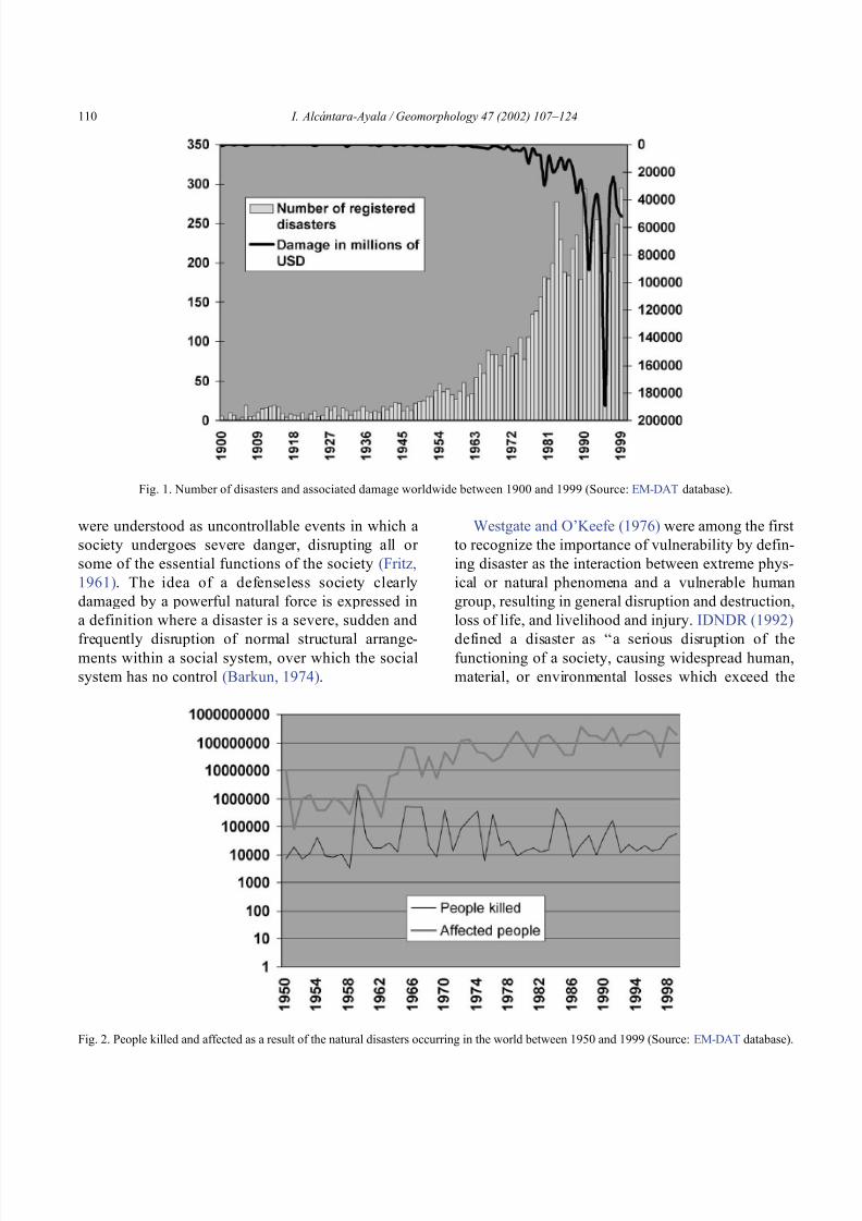
8102019 Articulo - Geomorphology Natural Hazards Vulnerability and Prevention of Natural Disasters in Developing Countrihellip
httpslidepdfcomreaderfullarticulo-geomorphology-natural-hazards-vulnerability-and-prevention-of 418
were understood as uncontrollable events in which a
society undergoes severe danger disrupting all or
some of the essential functions of the society (Fritz
1961) The idea of a defenseless society clearly
damaged by a powerful natural force is expressed in
a definition where a disaster is a severe sudden and
frequently disruption of normal structural arrange-ments within a social system over which the social
system has no control (Barkun 1974)
Westgate and OrsquoKeefe (1976) were among the first
to recognize the importance of vulnerability by defin-
ing disaster as the interaction between extreme phys-
ical or natural phenomena and a vulnerable human
group resulting in general disruption and destruction
loss of life and livelihood and injury IDNDR (1992)
defined a disaster as lsquolsquoa serious disruption of thefunctioning of a society causing widespread human
material or environmental losses which exceed the
Fig 1 Number of disasters and associated damage worldwide between 1900 and 1999 (Source EM-DAT database)
Fig 2 People killed and affected as a result of the natural disasters occurring in the world between 1950 and 1999 (Source EM-DAT database)
I Alca ntara-Ayala Geomorphology 47 (2002) 107ndash124110
8102019 Articulo - Geomorphology Natural Hazards Vulnerability and Prevention of Natural Disasters in Developing Countrihellip
httpslidepdfcomreaderfullarticulo-geomorphology-natural-hazards-vulnerability-and-prevention-of 518
Table 1
Some of the major geomorphology related natural disasters of the world from 1900 to 1999 (Data source EM-DAT and the Office of US
Foreign Disaster Assistance)
Disaster Year Country Killed Affected
Flood Jul-1931 Peoplersquos Republic of China 3700000 28500000
Flood Jul-1959 Peoplersquos Republic of China 2000000 ndash
Flood Oct-1949 Guatemala 40000 ndash
Floodmudslides Dec-1999 Venezuela 30000 600000
Flood Aug-1998 Peoplersquos Republic of China 3656 238973000
Flood 10-Aug-1998 India 1811 29227200
Flood 06-Aug-1998 Sudan 1393 338000
Flood 09-Sep-1998 Mexico 1256 400000
Flood 7-Jul-1993 India 827 128000000
Flood 28-Feb-1999 Mozambique 23 177000
Cyclone 18-Oct-1999 India 9465 15000000
Cyclone 2-Oct-1963 Grenada Trinidad y Tobago
Dominican Republic Haiti
Jamaica Cuba Bahamas
7258 ndash
Cyclone Nov-1964 Vietnam 7000 700000
Cyclone 3-Sep-1930 DominicaDominic Republic 6500 20000
Cyclone 8-Sep-1900 United States 6000 ndash
Cyclone (Mitch) 26-Oct-1998 Honduras 5657 2100000
Cyclone 09-Jun-1998 India 3000 4600000
Cyclone (Mitch) 26-Oct-1998 Nicaragua 2447 868000
Cyclone (Mitch) 26-Oct-1998 Guatemala 263 105700
Cyclone (Mitch) 26-Oct-1998 El Salvador 240 84000
Storm 25-Nov-1998 Bangladesh 200 121000
Earthquake 5-Oct-1948 Soviet Union 110000 ndash
Earthquake 28-Dec-1908 Italy 75000 150000
Earthquakedebris avalanche 31-May-1970 Peru 66794 3216240
Earthquake 6-Dec-1939 Turkey 32962 ndash
Earthquake 24-Jan-1939 Chile 30000 58500
Earthquake 13-Jan-1915 Italy 30000 ndash
Earthquake 4-Feb-1976 Guatemala 23000 4993000
Earthquake 17-Aug-1999 Turkey 15466 23954
Earthquake 21-Jan-1917 Indonesia 15000 ndash
Earthquake 28-Feb-1960 Morocco 12000 25000
Earthquake 23-Dec-1972 Nicaragua 10000 720000
Earthquake 21-Jan-1944 Argentina 10000 155000
Earthquake 19-Sep-1985 Mexico 8776 130204
Earthquake 16-Aug-1976 Philippines 6000 181348
Earthquake 29-Apr-1903 Turkey 6000 ndash
Earthquake 18-Feb-1951 Papua New Guinea 3000 ndash
Earthquake 26-Sep-1999 Taiwan 2084 100000
Earthquake 25-Jan-1999 Colombia 1171 745000Volcano 8-May-1902 Martinique 40000 ndash
Volcano 13-Nov-1985 Colombia 21800 12700
Volcano 1909 Indonesia 5500 ndash
Volcanomudflows 1919 Indonesia 5000 ndash
Volcano 15-Jan-1951 Papua New Guinea 3000 ndash
Volcano 21-Aug-1986 Cameroon 1734 4634
Avalanche 13-Dec-1916 ItalyAustria 10000 ndash
Tsunami 17-Jul-1998 Papua New Guinea 2182 9199
I Alca ntara-Ayala Geomorphology 47 (2002) 107ndash124 111
8102019 Articulo - Geomorphology Natural Hazards Vulnerability and Prevention of Natural Disasters in Developing Countrihellip
httpslidepdfcomreaderfullarticulo-geomorphology-natural-hazards-vulnerability-and-prevention-of 618
ability of affected society to cope using only its own
resources Disasters are often classified according to
their speed of onset (sudden or slow) or according to
their cause (natural or man-made)rsquorsquo
The dual character of natural disasters has been
addressed by considering not only the natural charac-
ter but also the social and economic systems As a
result a natural disaster can be defined as some rapid
instantaneous or profound impact of the natural envi-
ronment upon the socio-economic system (Alexander1993) or as a suddenly disequilibrium of the balance
between the forces released by the natural system and
the counteracting forces of the social system The
severity of such disequilibrium depends on the rela-
tion between the magnitude of the natural event and
the tolerance of human settlements to such an event
(Albala-Bertrand 1993) As explained by Tobin and
Montz (1997) a disaster is an event that has a big
impact on society It is a hazardous event that disrupts
the workings of society It may or may not lead to
deaths but it typically has severe economic impacts
By reviewing definitions of natural disasters it is
clear that there is a tendency to include either the
physical events as cause of the disaster or to acknowl-
Fig 3 Percentage of the number of disasters registered from 1900
until 1999 by regions of the world (Source EM-DAT database)
Fig 4 Occurrence of different types of disasters by regions of the globe Cylinder bars show the percentage of each particular disaster in a given
region in relation to the whole world (Source EM-DAT database)
I Alca ntara-Ayala Geomorphology 47 (2002) 107ndash124112
8102019 Articulo - Geomorphology Natural Hazards Vulnerability and Prevention of Natural Disasters in Developing Countrihellip
httpslidepdfcomreaderfullarticulo-geomorphology-natural-hazards-vulnerability-and-prevention-of 718
edge that the social and economic systems take part as
well as nature In some cases the possible consequen-
ces of the natural disasters are stated whereas the
reason why they occur is frequently omitted
32 Where do natural disasters occur
Natural disasters are a global issue as they occur all
over the world (Figs 1 and 2) Even though they may
have a considerable impact in countries such as Japan
USA France or Switzerland their significance in
countries such as Bangladesh India China Guate-
mala Colombia or Mexico is by far greater (Table 1)
The global death toll due to natural disasters is
concentrated in developing countries (also called
Third World Countries) and it can be as high as
95 of the total toll (Alexander 1993)
Most of the developing countries are located in
areas especially prone to natural hazards Volcanism is
associated with specific areas such as the Circum-
Pacific Volcanic Belt where approximately 80 of
the total activity takes place (Anderson and Decker
1992) Many Latin American and Asian countries are
located within this area and the effect volcanism and
its associated risks may cause to the population living
in close proximity is observed in disasters such as the
catastrophe of Nevado del Ruiz in Colombia (21800 people killed)
Asia and Latin America share the highest concen-
tration of flooding and associated risks due to hurri-
canes cyclones tropical storms typhoons and mon-
soons They are also the areas most susceptible to
earthquakes According to the registered natural dis-
asters which occurred between 1900 and 1999 (Fig 3)42 of the total number took place in Asia whereas
America had 27 Europe 13 and Oceania and
Africa 8 and 10 respectively (EM-DAT database
Office of US Foreign Disaster Assistance and the
Centre for Research on the Epidemiology of Disasters
OFDA CRED) The spatial distribution of natural dis-
asters (Fig 4) shows a clear tendency to occur in
developing countries In addition their impact is
reflected given the cost the consequences have in
relation to the GNP GDP and the time needed for
partial or total recovery For instance more than 9000
people lost their lives and about 11 (32 million
people) of the total population in Central America
was affected by the consequences of Hurricane Mitch
The impact was not homogeneous in all the countries
In Honduras the losses were equivalent to 80 of the
1997 GDP whereas those in Nicaragua were almost
49 of GDP The total losses of the whole region were
estimated at US$6 billion (Table 2) having a slightly
larger concentration of direct (515) than the indirect
(485) damage Furthermore the damage to the
population (Table 3) can be barely evaluated in finan-
cial t erms and in relation to the post-disaster recoverytime (CEPAL 1999)
The case of Hurricane Mitch in Central America
shows that even though the susceptibility of these
Table 2
Summary of damage in millions of dollars caused by Hurricane Mitch in Central America (Source CEPAL 1999 based on official figures and
their own estimates)
Total Direct damage Indirect damage Replacement cost
Total sectors 60183 31003 29180 44773
Social sectors 7985 5518 2466 9751
Housing 5909 4363 1546 7463
Health 1327 538 789 1170
Education 749 618 131 1118
Infrastructure 12455 6569 5886 17565
Roads bridges and railways 10695 5281 5415 14279
Energy 587 286 301 606
Water and sewerage systems 914 746 168 2244
Irrigation and drainage 258 256 02 436
Productive sectors 39069 18241 20828 16352
Farming fishing and forestry 29465 17019 12446 13020
Manufacturing industry 6080 328 5752 699
Trade restaurants and hotels 3524 894 2630 2633
Environment 674 674 00 1105
I Alca ntara-Ayala Geomorphology 47 (2002) 107ndash124 113
8102019 Articulo - Geomorphology Natural Hazards Vulnerability and Prevention of Natural Disasters in Developing Countrihellip
httpslidepdfcomreaderfullarticulo-geomorphology-natural-hazards-vulnerability-and-prevention-of 818
countries to natural disasters is high due to the
environmental setting (in a non-deterministic sense)
issues related to the social economic political and
cultural aspects of any social entity play a great role as
factors of vulnerability to natural disasters Although
poverty and natural disasters should not be considered
as synonyms it is certain that some characteristics
resulting from the economicndash socialndash politicalndash cul-
tural system reduce or eliminate equal access to
opportunities and therefore to development These
characteristics increase vulnerability Therefore the
occurrence of natural disasters in developing countries
is not only linked to the susceptibility of natural
hazards due to geologicalndashgeomorphological featuresand geographical location but also due to the vulner-
ability of the system where they exist
An example of the coupling of natural and
human vulnerability by analyzing the 1985 earth-
quake of Mexico City was presented by Blaikie et
al (1994) The city was erected on the bed of an
ancient lake making the soil highly vulnerable to
earthquakes and associated processes such as lique-
faction (natural vulnerability) Construction of build-
ings within the zone was performed using materials
of diverse type and quality during different periodsof time High population density low-income jobs
and poverty contributed to poor housing standards
(social and economic vulnerability) All the elements
derived from the particular natural social and
economic vulnerability of the area were combined
at the time of the earthquake producing zones of
disaster This case and the consequences of hurri-
cane Mitch underpin the need of both types of
vulnerability analysis to better understand and pre-
vent natural disasters
4 Natural disasters and geomorphology
Little has been done to associate geomorphology
and natural disasters directly Few publications in
geomorphology deal specifically with this issue (eg
Okuda 1970 Verstappen 1989 Rosenfeld 1994)
However innumerable works related to natural haz-
ards have represented the significance of geomorphol-
ogy to the natural disaster field Geomorphologists
have been concerned with the understanding analysis
and forecast of hazards such as flooding mass move-
ment earthquakes and volcanism
Flooding associated with hydrometeorological phe-
nomenon namely tropical storms hurricanes mon-soons (Kale et al 1994) El Nino or La Nina is
regarded as one of the most dangerous natural hazards
and principal trigger of disasters Fluvial geomorphol-
ogists have paid considerable attention to flooding
Approaches to understand this process include the
study of past events or palaeoflood geomorphology
and flood hydrology (Enzel et al 1993 Baker 1994
Kale et al 1997) Furthermore flood simulations
(Enzel and Wells 1997 Bates and De Roo 2000
Chang et al 2000) forecasting (Chowdhury 2000)
and flood maps elaborated by using GeographicalInformation Systems (GIS) (Merzi and Aktas 2000)
radar imagery (Zhou et al 2000) and remote sensing
(Islam and Sado 2000 Siegel and Gerth 2000) have
been a crucial aspect in the development of hazard and
risk assessment and management
Based on different approaches such as mapping
(Canuti et al 1987 Leroi 1997 Yin 1994) the
elaboration of inventories (Al-Homoud and Tubeileh
1997 Chacon et al 1996 Guzzetti et al 1994)
analysis of historical archives (Brunsden 1993 Ibsen
Table 3
Population affected by Hurricane Mitch in Central America (Source CEPAL 1999 based on official figures)
Item Total Costa Rica El Salvador Guatemala Honduras Nicaragua
(1) Dead 9214 4 240 268 5657 3045(2) Missing 9171 3 19 121 8058 970
(3) Injured 12842 ndash ndash 280 12275 287
(4) In shelters 466271 5411 55864 54725 285000 65271
(5) Total evacuated and direct victims 1191908 16500 84316 105000 617831 368261
(6) Population directly affected 3464662 20000 346910 730000 1500000 867752
(7) Children under five 1801624 10400 180393 379600 780000 451231
(8) Total population 31648907 3270700 6075536 11645900 6203188 4453583
(9) Percentage affected 109 06 57 63 242 195
I Alca ntara-Ayala Geomorphology 47 (2002) 107ndash124114
8102019 Articulo - Geomorphology Natural Hazards Vulnerability and Prevention of Natural Disasters in Developing Countrihellip
httpslidepdfcomreaderfullarticulo-geomorphology-natural-hazards-vulnerability-and-prevention-of 918
8102019 Articulo - Geomorphology Natural Hazards Vulnerability and Prevention of Natural Disasters in Developing Countrihellip
httpslidepdfcomreaderfullarticulo-geomorphology-natural-hazards-vulnerability-and-prevention-of 1018
panorama of the occurrence of such events and their
consequences
In the geomorphological dimensions of natural
disasters Rosenfeld (1994) examined the contribu-
tions of different geomorphological projects to inter-
disciplinary research including rainfall-induced land-
sliding cyclonic storms flooding etc Certainly the
use of remote sensing Global Positioning System
(GPS) and GIS has led to the incorporation of geo-
morphologists into the mapping analysis and model-
ing of such geophysical hydrological and geomor-
phological processes within the natural and human
hazards approach Rosenfeld illustrated the relation-
ship between the natural and human sides of the
Fig 6 Natural and geomorphology related disasters registered from 1990 to 1999 worldwide (Source EM-DAT database)
Fig 7 Estimated damage due to natural and geomorphology related disasters from 1990 to 1999 (Source EM-DAT database)
I Alca ntara-Ayala Geomorphology 47 (2002) 107ndash124116
8102019 Articulo - Geomorphology Natural Hazards Vulnerability and Prevention of Natural Disasters in Developing Countrihellip
httpslidepdfcomreaderfullarticulo-geomorphology-natural-hazards-vulnerability-and-prevention-of 1118
extent of natural hazards by using a pyramid-form
graph where the faces represent the duration and areal
extents of different hazards in terms of casualties and
hazard severity according to the different degree of
development of the countries and based on the level
response needed to cope with the disasters as a
function of economic development
By analyzing the EM-DAT database which
includes phenomena such as slides floods earth-
quakes volcanoes wind storms extreme tempera-
tures droughts wild fires and epidemics as natural
disasters it can be noticed that with exception of
extreme temperatures and epidemics all the other
ph en omen a are ge omor ph ol ogy rela te d Fig 5
presents the percentage of those disasters related to
geomorphology by type and region from 1900 to
1999 Between 1990 and 1999 2808 disasters were
recorded worldwide Eighty four percent of them wererelated to geomorphology (Fig 6) The total amount
of estimated damage (Fig 7) in relation to the global
natural disasters registered within the same period of
time and the number of people reported killed (Table
4) and affected (Fig 8) give a good indication of the
significance of geomorphology for the prevention of
natural disasters
The contribution of geomorphology to the field of
natural disasters is mainly through the elaboration of
hazard assessments In general such assessments
comprise stages like mapping modeling prediction
and management proposals using field observations
photogrammetry geographical information systems
and remote sensing the zonation and mapping of
different hazards is done Modeling approaches con-
sider not only the understanding of present but past
events leading to accurate predictions of the conse-
quences a geomorphic hazard may have on a deter-
mined landscape under a given conditions
Hazard assessment is a key part within the risk
analysis process Certainly geomorphologists have
contributed enormously on this matter Nevertheless
Table 4
Total number of people reported killed by continent and by type of
phenomenon from 1990 to 1999 (Source EM-DAT database)
Africa Americas Asia Europe Oceania Total
Slides 225 2010 5500 644 279 8658
Droughts 12 0 2680 0 98 2790
Earthquakes 816 3519 91878 2395 70 98678
Floods 9487 35598 55916 2839 30 103870
Wind Storms 1612 13264 185739 913 262 201790
Volcanoes 0 77 994 0 9 1080
Total 12152 54468 342707 6791 748 416866
Fig 8 People affected due to natural and geomorphology related disasters from 1990 to 1999 (Source EM-DAT database)
I Alca ntara-Ayala Geomorphology 47 (2002) 107ndash124 117
8102019 Articulo - Geomorphology Natural Hazards Vulnerability and Prevention of Natural Disasters in Developing Countrihellip
httpslidepdfcomreaderfullarticulo-geomorphology-natural-hazards-vulnerability-and-prevention-of 1218
a greater progress would be achieved if vulnerability
analysis were also taken into account
5 Geomorphology vulnerability and disasters
By examining the different definitions of natural
hazards and natural disasters it is clear that the
conceptualization has changed from a perspective of
a merely physical or natural event towards the inte-
gration of the human system Initially the uncontrol-
lable character of natural hazards directed efforts
towards coping with their impacts and also towards
the prediction of these events Technological advances
and the development of prediction models for vol-
canic activity hurricanes tsunamis flooding land-
sliding etc were developed seeking a better under-
standing of the phenomena and to some extent to offer
possibilities to cope with the impact of natural haz-
ards but mainly in lsquodeveloped countriesrsquo
Later in the 1960s the idea of the devastation by
natural disasters as a result of the social and economic
characteristics of the regions where natural hazards
took place was introduced (White 1961 1964 Kates
1962 Burton et al 1968 Hewitt and Burton 1971)
However it was not until the 1970s that the role of
economic and social conditions as factors of vulner-ability to natural disasters was acknowledged
The interest of understanding not only the natural
events per se but the characteristics of risk in the
areas prone to these phenomena has moved the
attention of many social scientists towards the study
of risk and vulnerability (eg Albala-Bertrand 1993
Blaikie et al 1994 Cannon 1993 Varley 1991
Winchester 1992) Previous investigations have
shown the need for defining and measuring hazard
events in a non-scientific (physical) view This
includes the description and analyses of different perceptions of hazard (Burton et al 1968) based on
the concept of differential perception of risk a very
important factor in the development of risk manage-
ment approaches
At the present time not only social scientists but
geoscientists are considering the socio-economic char-
acter of some regions prone to natural hazards as one
of the main factors of vulnerability to natural disasters
For instance Cardona (1997) considered the social
economic and institutional aspects within the manage-
ment of the crisis of Galer as volcano in Colombia
Dibben and Chester (1999) proposed a framework to
analyze human vulnerability in the case of Furnas
volcano in the Azores They recognized that peoplersquosvulnerability to volcanic hazards implies an interaction
of different elements related to the social context and
the corresponding physiological and psychological
characteristics In his overview of volcanic geomor-
phology Thouret (1999) pointed out that in order to
cope with the consequences of natural hazards and their
interaction with people living around the volcanoes
geomorphology is an essential part to undertake risk
assessment based on geomorphic hazard and risk
zonation
51 A closer look to vulnerability
The study of vulnerability related to natural disas-
ters has been the focus of different investigations and
hence of several definitions Westgate and OrsquoKeefe
(1976) defined vulnerability as the degree to which a
community is at risk from the occurrence of extreme
physical or natural phenomena where risk refers to the
probability of occurrence and the degree to which
socio-economic and socio-political factors affect the
communityrsquos capacity to absorb and recover from
extreme phenomena For Varley (1991) vulnerabilityis a function of the degree of social and self-protection
available to potential victims It is clearly related to the
ability of households or communities to cope with and
recover from outside events and particularly to shocks
and sudden changes (Maskey 1993) It also concerns
the predisposition of a society to experience substan-
tial damage as a result of natural hazards (Clarke and
Munasinghe 1995) These definitions imply that vul-
nerability is the result of the socio-economic and
political systems of the entity in danger However it
is the definition of Cannon (1993) which considersdifferent factors affecting or producing the vulnerabil-
ity of individuals or groups that is most germane
According to him vulnerability lsquolsquois a characteristic of
individuals and groups of people who inhabit a given
natural social and economic space within which they
are differentiated according to their varying position in
society into more or less vulnerable individuals and
groups It is a complex characteristics produced by a
combination of factors derived especially (but not
entirely) from class gender or ethnicityrsquorsquo Cannon
I Alca ntara-Ayala Geomorphology 47 (2002) 107ndash124118
8102019 Articulo - Geomorphology Natural Hazards Vulnerability and Prevention of Natural Disasters in Developing Countrihellip
httpslidepdfcomreaderfullarticulo-geomorphology-natural-hazards-vulnerability-and-prevention-of 1318
divided vulnerability into three parts (1) Livelihood
resilience the degree of resilience of the particular
livelihood system of an individual or group and their
capacity for resisting the impact of hazard (2) Healthincluding both the robustness of individuals and the
operation of various social measures (3) Preparedness
determined by the protection available for a given
hazard something that depends on people acting on
their own behalf and social factors
These three aspects cover a great proportion of the
different kinds of vulnerabilities Nevertheless each
aspect has different components and the combinations
of them can be so numerous that it is necessary to
specify the particular types of vulnerability of each
threatened entity The latter will provide an adequate
understanding of the total vulnerability to natural
disasters so that prevention can be effectively accom-
plished This insight strengthens the contribution of
Aysan (1993) who recognizes different kinds of
vulnerability as follows
Lack of access to resources (materialseconomic
vulnerability) Disintegration of social patterns (social vulnerabil-
ity) Lack of strong national and local institutional
structures (organizational vulnerability) Lack of access to information and knowledge
(educational vulnerability) Lack of public awareness (attitudinal and motiva-
tional vulnerability) Limited access to political power and representa-
tion (political vulnerability) Certain beliefs and customs (cultural vulner-
ability) Weak buildings of weak individuals (physical
vulnerability)
There are indeed many other kinds of vulnerability
However all of them can be inserted within four main
types of vulnerability social economic political and
cultural This classification indicates that each social
entity has different types of vulnerability and it is not
only the result of the human actions decisions and
choices it is the result of the interaction of the natural
economic social cultural and political contexts where
people live Vulnerability cannot be treated as a
homogeneous and general term its dynamism is given
by each society and it is both a universal and
particular concept There is certainly a differential
character of vulnerability Vulnerability is given by
t he coupling between the natural and human systems(Fig 9) In this sense vulnerability can be divided
into natural vulnerability and human vulnerability
Natural vulnerability depends on the threatening nat-
ural hazard (very much related to geographical loca-
tion) thus there is volcanic vulnerability flooding
vulnerability landsliding vulnerability tsunamis vul-
nerability hurricane vulnerability and so on On con-
trast human vulnerability is based on the social
economical political and cultural systems
Hence vulnerability can be defined as the propen-
sity of an endangered element due to any kind of
natural hazard to suffer different degrees of loss or
amount of damage depending on its particular social
economic cultural and political weaknesses Total
vulnerability is a function of the individual types of
vulnerability present in a given area Such vulnerabil-
ity determines the magnitude of the disaster the level
of resilience and the recovery process
52 A step forward into the prevention of natural
disasters applied geomorphology
The reduction of natural vulnerability could beobtained from an equal access to scientific informa-
tional resources and methodologies for the understand-
ing and prediction of natural hazards (eg state-of-art
predicting models) and to international training pro-
grams Natural hazards cannot be prevented but the
understanding of the process and scientific method-
ologies to predict patterns of behavior of such pro-
cesses can be powerful tools to help reduce natural
vulnerability
Geomorphological research can provide theoretical
and applied approaches to the prevention of naturaldisasters in terms of origin and dynamism of the
physical processes Furthermore geomorphologists
could also offer important contributions based on the
understanding of the interaction between natural haz-
ards (natural vulnerability) and the societies (human
vulnerability) Consequently they should be involved
to a greater extent in such tasks as is the case of the
contributions of D Alexander M Panizza and HT
Verstappenmdashto mention the most familiar examplesmdash
who not only have shed light on understanding geo-
I Alca ntara-Ayala Geomorphology 47 (2002) 107ndash124 119
8102019 Articulo - Geomorphology Natural Hazards Vulnerability and Prevention of Natural Disasters in Developing Countrihellip
httpslidepdfcomreaderfullarticulo-geomorphology-natural-hazards-vulnerability-and-prevention-of 1418
morphological processes but also on the strong link
between the processes and society
Geomorphology can be considered a strategic
discipline in the reduction of both human and natural
vulnerabilities By contributing to the understanding
of endogenetic and exogenetic processes method-
ologies to predict patterns of occurrence of hazardous
events can be developed and applied Geomorpholo-
gists assist in the reduction of natural vulnerability inthree different ways first by enriching the theoretical
knowledge of geomorphology which is the base of
the application of our discipline second by develop-
ing prediction models for different processes such as
landsliding flooding volcanism among others and
finally through diversified approaches of applied
geomorphology for the prevention of natural disas-
ters Indeed geomorphology is a powerful field that
must play a role in the interdisciplinary efforts to
develop adequate strategies for prevention and miti-
gation of natural disasters Nonetheless contributions
of geomorphology would be even more significant if
research applications were directed towards the
understanding and coupling of human and natural
vulnerabilities Reduction of natural disasters is a
complex task by nature however it is now clear
that a combination not only of social and scientific
knowledge but also of attitudes towards the elabo-
ration of adequate strategies based on vulnerabilityanalysis of the particular social entities is urgently
required
6 Conclusions
Natural hazards are threatening events capable of
producing damage to the physical and social space in
which they take place not only at the moment of their
occurrence but in the long-term due to their associ-
Fig 9 The ingredients of natural disasters
I Alca ntara-Ayala Geomorphology 47 (2002) 107ndash124120
8102019 Articulo - Geomorphology Natural Hazards Vulnerability and Prevention of Natural Disasters in Developing Countrihellip
httpslidepdfcomreaderfullarticulo-geomorphology-natural-hazards-vulnerability-and-prevention-of 1518
ated consequences When these consequences have an
impact on society andor infrastructure they become
natural disasters These can be considered as sudden
but expected (we all know that they occur) naturalevents which impact the human and natural systems
The degree of their impact in space and time is a
function of the exposure to and the magnitude of the
natural phenomena (natural vulnerability) and the
human vulnerability of the threatened entity
Natural disasters occur all over the world how-
ever their impact in developing countries is greater
due to the geographical location in zones highly
susceptible to natural hazards (natural vulnerability)
and also due to the different types of economic social
political and cultural vulnerabilities that exist These
vulnerabilities are indeed the result of their historical
development and their social political economic and
cultural contexts The rich get richer the poor poorer
and the access to opportunities within the social entity
are unequal and indirectly proportional to the occur-
rence of natural disasters (the less opportunities the
more vulnerability the more affected by natural dis-
asters)
The International Decade for Natural Disaster
Reduction (IDNDR) has achieved several goals such
as the organization of international groups to provide
advice on the prevention of natural disasters onregional and national bases Events such as Hurricane
Mitch in Central America (October 1998) the earth-
quake in Turkey (August 1999) and their devastating
consequences demonstrated that natural disasters
occur in places where the geographical coordinates
of natural and human vulnerabilities converge An
effort must be made to promote the elaboration of
vulnerability analysis within a risk assessment and
management framework where not only geomor-
phology but also geomorphologists play a key role
for the prevention of natural disasters The latter needs indeed to be more rapidly implemented in
developing countries
Acknowledgements
Natural disasters registered data were kindly
provided by the ODFACRED International Disaster
Database Center for Research into the Epidemiology of
Disasters (CRED) Catholic University of Louvain
Belgium (httpwwwmduclacbecred) and the Of-
fice of US Foreign Disaster Assistance (httpwww
usaidgovhum _ responseofda ) Thanks are also due to
BE Montz CL Rosenfeld and PLK Knuepfer for critical reviewing of this paper
References
Albala-Bertrand JM 1993 Political Economy of Large Natural
Disasters With Special Reference to Developing Countries Ox-
ford Univ Press London 259 pp
Alexander D 1993 Natural Disasters UCL Press and Chapman amp
Hall New York 632 pp
Al-Homoud AS Tubeileh T 1997 An inventory for evaluating
hazard and risk assessment of cut slopes in weak rocks along
highways Bull Int Assoc Eng Geol 55 39ndash51Anderson JL Decker RW 1992 Volcano risk mitigation
through training In McCall GJH Laming DJC Scott
SC (Eds) Geohazards Natural and Man-Made Chapman amp
Hall London pp 7 ndash 12
Anderson MG Collison AJC Hartshorne J Lloyd DM
Park A 1996 Developments in slope hydrology-stability mod-
eling for tropical slopes In Anderson MG Brooks SM
(Eds) Advances in Hillslope Processes vol 2 Wiley Chiches-
ter pp 799ndash821
Aysan YF 1993 Vulnerability assessment In Merriman PA
Browitt CWA (Eds) Natural Disasters Protecting Vulnerable
Communities Thomas Telford London pp 1 ndash 14
Baker VR 1994 Geomorphological understanding of floods Geo-
morphology 10 139ndash156
Barkun N 1974 Disaster and the Millenium Yale Univ Press
New Haven
Bates PD De Roo APJ 2000 A simple raster-based model for
flood inundation simulation J Hydrol 236 54ndash77
Blaikie P Cannon T Davis I Wisner B 1994 At Risk Natural
Hazards Peoplersquos Vulnerability and Disasters Routledge Lon-
don 284 pp
Brooks SM Collison AJC 1996 The significance of soil pro-
file differentiation to hydrological response and slope instability
a modeling approach In Anderson MG Brooks SM (Eds)
Advances in Hillslope Processes vol 2 Wiley Chichester pp
471ndash486
Brunsden D 1993 Mass movement the research frontier and bey ond a geomor phological approa ch Geom orp hology 7
85ndash128
Brunsden D 1999 Some geomorphological considerations for the
future development of landslide models Geomorphology 30
13ndash24
Burton I Kates RW 1964 The perception of natural hazards in
resource management Nat Resour J 3 412ndash441
Burton I Kates RW White GF 1968 The Human Ecology of
Extreme Geophysical Events Department of Geography Natu-
ral Hazards Research Working Paper No 1 University of Tor-
onto
Cannon T 1993 A hazard need not a disaster make vulnerability
I Alca ntara-Ayala Geomorphology 47 (2002) 107ndash124 121
8102019 Articulo - Geomorphology Natural Hazards Vulnerability and Prevention of Natural Disasters in Developing Countrihellip
httpslidepdfcomreaderfullarticulo-geomorphology-natural-hazards-vulnerability-and-prevention-of 1618
and the causes of lsquonaturalrsquo disasters In Merriman PA Bro-
witt CWA (Eds) Natural Disasters Protecting Vulnerable
Communities Thomas Telford London pp 92ndash 105
Canuti P Focardi P Garzonia CA Rodolfi G Vannocci P
1987 Slope stability mapping in Tuscany Italy In Gardiner V(Ed) International Geomorphology 1986 Part I Wiley London
pp 231 ndash 240
Cardona OD 1997 Management of the volcanic crises of Galeras
volcano social economic and institutional aspects J Volcanol
Geother Res 77 313ndash324
Carrara A Cardinali M Detti R Guzzetti F Pasqui V Reich-
enbach P 1990 Geographical information systems and multi-
variate models in landslide hazard evaluation In Cancelli A
(Ed) Alps 90 Int Conf and Field Workshop on Landslides
Milano pp 17ndash 28
CEPAL 1999 Central America Assessment of the Damage Caused
by Hurricane Mitch 1998 Implications for Economic and So-
cial Development and for the Environment 41 pp At http
wwwcepalorgmx
Chacon J Irigaray C El Hamdouni R Fernandez T 1996
From the inventory to the risk analisis improvements to a large
scale GIS method In Chacon J Irigaray C Fernandez T
(Eds) Landslides Balkema Rotterdam pp 335ndash342
Chandler JH Brunsden D 1995 Steady state behaviour of the
Black Ven mudslide the application of archival analytical pho-
togrammetry to studies of landform change Earth Surf Pro-
cesses Landf 20 255ndash275
Chandler JH Cooper MAR 1989 The extraction of positional
data from historical photographs and their application in geo-
morphology Photogramm Rec 13 (73) 69 ndash 78
Chandler JH Moore R 1989 Analytical photogrammetry a
method for monitoring slope instability Q J Eng Geol 2297ndash110
Chang TJ Hsu MH Teng WH Huang CJ 2000 A GIS-
assisted distributed watershed model for simulating flooding and
inundation J Am Wat Resour Assoc 36 (5) 975 ndash 988
Chowdhury MR 2000 An assessment of flood forecasting in
Bangladesh the experience of the 1998 flood Nat Hazards
22 (2) 139ndash163
Clarke C Munasinghe M 1995 Economic aspects of disasters
and sustainable development an introduction In Munasinghe
M Clarke C (Eds) Disaster Prevention for Sustainable De-
velopment Economy and Policy Issues IDNDR and the World
Bank Washington pp 1ndash10
Collison AJC Anderson MG 1996 Using a combined slope
hydrology-slope stability model to identify suitable conditionsfor landslide prevention by vegetation in the humid tropics
Earth Surf Processes Landf 21 (8) 737ndash747
Collison AJC Anderson MG Lloyd DM 1995 The impact
of vegetation on slope stability in a humid tropical environment
a modeling approach Inst Civil Eng Water Marit Energy 112
168ndash175
Corominas J Moya J 1996 Historical landslides in the eastern
Pyrenees and their relation to rainy events In Chacon J Iri-
garay C Fernandez T (Eds) Landslides Balkema Rotter-
dam pp 125ndash132
Dibben C Chester DK 1999 Human vulnerability in volcanic
environments the case of Furnas Sao Miguel Azores J Vol-
canol Geother Res 92 (1ndash2) 133ndash150
Dikau R Jaeger S 1993 The role of geomorphology in regional
landslide hazard assessment using GIS technologies In Reich-
enbach P Guzzetti F Carrara A (Eds) Workshop on Geo-graphic Information Systems in Assessing Natural Hazards
Univ Foreigners Perugia Italy pp 54 ndash 55
Dikau R Cavallin A Jaeger S 1992 Database and GIS for
landslide research in Europe In Casale R Fantechi R Flag-
eollet JC (Eds) Temporal Occurrence and Forecasting of
Landslides in the European Community Final Report vol 1
pp 97 ndash 116
Domınguez-Cuesta MJ Jimınez-Sanchez M Rodrıguez-Garcıa
A 1999 Press archives as temporal records of landslides in the
north of Spain relationships between rainfall and instability
slope events Geomorphology 30 125ndash132
Dowdeswell JA Lamb HF Lewin J 1988 Failure and flow on
a 35 degrees slope causes and three-dimensional observations
Earth Surf Processes Landf 13 737ndash746
Elsinga RJ Verstappen HT 1988 SPOT for earthquake hazard
zoning in southern Italy SPOT 1 Image utilization assessment
results Techniques Spatiales 1 Centre National drsquoEtudes Spa-
tiales Toulouse France pp 199ndash207
EM-DAT The OFDACRED International Disaster Database At
httpwwwcredbeemdat Universite Catholique de Louvain
Brussels Belgium
Enzel Y Wells SG 1997 Extracting Holocene paleohydrology
and paleoclimatology information from modern extreme flood
events an example from Southern California Geomorphology
19 203ndash226
Enzel Y Ely LL House PK Baker VR Webb RH 1993
Paleoflood evidence for a natural upper bound to flood magni-tudes in the Colorado River Water Resour Res 29 (7) 2287ndash
2297
Erdik M Biro YA Onur T Sesetyan K Birgoren G 1999
Assessment of earthquake hazard in Turkey and neighboring
regions Ann Geofis 42 1125ndash1138
Fritz CE 1961 Disasters In Merton RK Nisbet RA (Eds)
Contemporary Social Problems Harcourt New York pp 651ndash
694
Galadini F Galli P 2000 Active tectonics in the central Apen-
nines (Italy)mdashinput data for seismic hazard assessment Nat
Hazards 22 (3) 225ndash270
Gares PA Sherman DJ Nordstrom KF 1994 Geomorphology
and natural hazards Geomorphology 10 1ndash18
Gili JA Corominas J Rius J 2000 Using global positioningsystem techniques in landslide monitoring Eng Geol 55 (3)
167ndash192
Gomez-Fernandez F 2000 Contribution of geographical informa-
tion systems to the management of volcanic crises Nat Hazards
21 (2ndash 3) 347ndash 360
Guzzetti F Cardinali M Reichenbach P 1994 The AVI project
a bibliographical and archive inventory of landslides and floods
in Italy Environ Manage 18 (4) 623ndash633
Hansen A 1984 Landslide hazard analysis In Brunsden D
Prior DB (Eds) Slope Instability Wiley Chichester pp
523ndash602
I Alcantara-Ayala Geomorphology 47 (2002) 107ndash124122
8102019 Articulo - Geomorphology Natural Hazards Vulnerability and Prevention of Natural Disasters in Developing Countrihellip
httpslidepdfcomreaderfullarticulo-geomorphology-natural-hazards-vulnerability-and-prevention-of 1718
Hewitt K Burton I 1971 The Hazardousness of a Place A
Regional Ecology of Damaging Events Research Paper No 6
Department of Geography University of Toronto
Hutchinson JN 1992 Landslide Hazard Assessment Proc 6th
Int Symp on Landslides Christchurch New Zealand vol 3 pp 3 ndash 35
Ibsen ML Brunsden D 1996 The nature use and problems of
historical archives for the temporal occurrence of landslides
with specific reference to the south coast of Britain Ventnor
Isle of Wight Geomorphology 15 241ndash258
IDNDR 1992 Glossary Internationally Agreed Glossary of Basic
Terms Related to Disaster Management DHA-Geneva 83 pp
Islam MDM Sado K 2000 Development of flood hazard maps
of Bangladesh using NOAA-AVHRR images with GIS Hydrol
Sci J 45 337ndash355
Jenkins A Ashworth PJ Ferguson RI Grieve IC Rowling
P Stott TA 1988 Slope failures in the Ochil Hills Scotland
November 1984 Earth Surf Processes Landf 13 69 ndash 76
Kale VS Ely LL Enzel Y Baker VR 1994 Geomorphic and
hydrologic aspects of monsoon floods on the Narmada and Tapi
Rivers in central India Geomorphology 10 157ndash168
Kale VS Hire P Baker VR 1997 Flood hydrology and geo-
morphology of monsoon-dominated rivers the Indian Peninsu-
la Water Int 22 259ndash265
Kates RW 1962 Hazard and Choice Perception in Flood Plain
Management Research Paper No 78 Department of Geogra-
phy University of Chicago
Leroi E 1997 Landslide risk mapping problems limitations and
developments In Cruden DM Fell R (Eds) Landslide Risk
Assessment Balkema Rotterdam pp 239 ndash 250
Mantovani F Soeters R Van Westen CJ 1996 Remote sensing
techniques for landslide studies and hazard zonation in EuropeGeomorphology 15 213ndash225
Maskey A 1993 Vulnerability accumulation in peripheral regions
in Latin America the challenge for disaster prevention and
management In Merriman PA Browitt CWA (Eds) Nat-
ural Disasters Protecting Vulnerable Communities Thomas
Telford London pp 461ndash472
Merzi N Aktas MT 2000 Geographic information systems
(GIS) for the determination of inundation maps of Lake Mogan
Turkey Water Int 25 (3) 474ndash480
Montgomery DR Dietrich WE 1994 A physically based model
for the topographic control on shallow landsliding Water Re-
sour Res 30 (4) 1153ndash1171
Okuda S 1970 On the relation between physical geomorphology
and the science of natural disasters Bull Disaster Prev ResInst 19 (25) Part 5 Kyoto Japan
Ordaz M Reyes C 1999 Earthquake hazard in Mexico City
observations versus computations Bull Seismol Soc Am 89
(5) 1379ndash 1383
Panizza M 1981 Geomorphology and earthquake hazard in envi-
ronmental planning In Palmentola G Acquafredda P (Eds)
Proceedings of the International Conference on Seismic Zones
in the Mediterranean Area Basilicata Italy pp 203ndash207
Panizza M 1991 Geomorphology and seismic risk Earth-Sci
Rev 31 (1) 11ndash20
Pareschi MT Cavarra L Favalli M Giannini F Meriggi A
2000 GIS and volcanic risk management Nat Hazards 21 (2ndash
3) 361ndash379
Petley DN 1998 Geomorphological mapping for hazard assess-
ment in a neotectonic terrain Geogr J 164 (7) 183ndash201
Proske H 1996 GIS supported analysis of effects of joint systemson shallow landslides in a tectonically complex crystalline
catchment area In Chacon J Irigaray C Fernandez T
(Eds) Landslides Balkema Rotterdam pp 173ndash180
Rosenfeld CL 1994 The geomorphological dimensions of natural
disasters Geomorphology 10 27ndash36
Scheidegger AE 1994 Hazards singularities in geomorphic sys-
tems Geomorphology 10 19ndash25
Siegel H Gerth M 2000 Satellite-based studies of the 1997 Oder
flood event in the southern Baltic Sea Remote Sens Environ
73 (2) 207ndash217
Singhroy V Mattar KE Gray AL 1998 Landslide character-
isation in Canada using interferometric SAR and combined SAR
and TM images Adv Space Res 21 (3) 465ndash476
Slaymaker O 1996 Introduction In Slaymaker O (Ed) Geo-
morphic Hazards Wiley Chichester pp 1ndash7
Sousa J Voight B 1992 Computational flow modeling for long-
runout landslide hazard assessment with an example from Cla-
piere landslide France Bull Assoc Eng Geol 29 (2) 131 ndash
150
Summerfield MA 1991 Global Geomorphology An Introduction
to the Study of Landforms Wiley New York 537 pp
Terlien MTJ 1996 The prediction of rainfall-triggered soil slips
in Manizales (Colombia) In Chacon J Irigaray C Fernan-
dez T (Eds) Landslides Balkema Rotterdam pp 197 ndash 205
Thornes JB Alcantara-Ayala I 1998 Modelling mass failure in a
Mediterranean mountain environment climatic geological
topographical and erosional controls Geomorphology 24 87ndash 100
Thouret JC 1999 Urban hazards and risks consequences of
earthquakes and volcanic eruptions an introduction GeoJournal
49 (2) 131ndash135
Tobin GA Montz BE 1997 Natural Hazards Explanation and
Integration The Guilford Press New York 388 pp
UNDRO 1982 Natural Disasters and Vulnerability Analysis Of-
fice of the United Nations Disaster Relief Coordinator Geneva
Switzerland
Van Asch TWJ Buma JT 1997 Modelling groundwater fluc-
tuations and the frequency of movement of a landslide in the
Terres Noires region of Barcelonnette (France) Earth Surf Pro-
cesses Landf 22 131ndash141
Varley A 1991 Disasters vulnerability and response Disasters 15(3) 285ndash287
Verstappen HT 1988 Geomorphological surveys and natural haz-
ard zoning with special reference to volcanic hazards in central
Java Z Geomorphol Supplbd 68 81ndash101
Verstappen HT 1989 Geomorphology natural disasters and glob-
al change Symposium on Aerospace Survey and Natural Dis-
asters ITC J (3ndash4) 159ndash164
Verstappen HT 1992 Volcanic hazards in Colombia and Indone-
sia lahars and related phenomena In McCall GJH Laming
DDC Scott SC (Eds) Geohazards Natural and Man-Made
Chapman amp Hall London pp 33ndash42
I Alcantara-Ayala Geomorphology 47 (2002) 107ndash124 123
8102019 Articulo - Geomorphology Natural Hazards Vulnerability and Prevention of Natural Disasters in Developing Countrihellip
httpslidepdfcomreaderfullarticulo-geomorphology-natural-hazards-vulnerability-and-prevention-of 1818
Westgate KN OrsquoKeefe P 1976 Some Definitions of Disaster
Disaster Research Unit Occasional Paper No 4 Department of
Geography University of Bradford
White GF (Ed) 1961 Papers on Flood Problems Research Pa-
pers No 70 Department of Geography University of ChicagoWhite GF 1964 Choice of Adjustments to Floods Research Pa-
per No 93 Department of Geography University of Chicago
White GF 1973 Natural hazards research In Chorley RJ (Ed)
Directions in Geography Methuen London pp 193 ndash 216
Winchester P 1992 Power Choice and Vulnerability A Case
Study in Disaster Management in South India James amp James
London 225 pp
Wolman MG Miller JP 1960 Magnitude and frequency of
forces in geomorphic processes J Geol 68 (1) 54ndash74
Yin KL 1994 A computer-assisted mapping of landslide hazardevaluation 7th International IAEG Congress Balkema Rotter-
dam pp 4495ndash 4499
Zhou CH Luo JC Yang CJ Li BL Wang SL 2000 Flood
monitoring using multi-temporal AVHRR and RADARSAT im-
agery Photogramm Eng Remote Sensing 66 (5) 633ndash638
I Alca ntara-Ayala Geomorphology 47 (2002) 107ndash124124
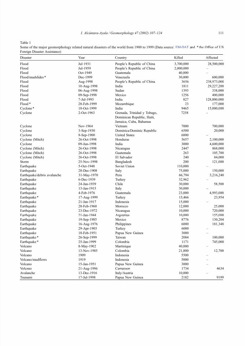
8102019 Articulo - Geomorphology Natural Hazards Vulnerability and Prevention of Natural Disasters in Developing Countrihellip
httpslidepdfcomreaderfullarticulo-geomorphology-natural-hazards-vulnerability-and-prevention-of 518
Table 1
Some of the major geomorphology related natural disasters of the world from 1900 to 1999 (Data source EM-DAT and the Office of US
Foreign Disaster Assistance)
Disaster Year Country Killed Affected
Flood Jul-1931 Peoplersquos Republic of China 3700000 28500000
Flood Jul-1959 Peoplersquos Republic of China 2000000 ndash
Flood Oct-1949 Guatemala 40000 ndash
Floodmudslides Dec-1999 Venezuela 30000 600000
Flood Aug-1998 Peoplersquos Republic of China 3656 238973000
Flood 10-Aug-1998 India 1811 29227200
Flood 06-Aug-1998 Sudan 1393 338000
Flood 09-Sep-1998 Mexico 1256 400000
Flood 7-Jul-1993 India 827 128000000
Flood 28-Feb-1999 Mozambique 23 177000
Cyclone 18-Oct-1999 India 9465 15000000
Cyclone 2-Oct-1963 Grenada Trinidad y Tobago
Dominican Republic Haiti
Jamaica Cuba Bahamas
7258 ndash
Cyclone Nov-1964 Vietnam 7000 700000
Cyclone 3-Sep-1930 DominicaDominic Republic 6500 20000
Cyclone 8-Sep-1900 United States 6000 ndash
Cyclone (Mitch) 26-Oct-1998 Honduras 5657 2100000
Cyclone 09-Jun-1998 India 3000 4600000
Cyclone (Mitch) 26-Oct-1998 Nicaragua 2447 868000
Cyclone (Mitch) 26-Oct-1998 Guatemala 263 105700
Cyclone (Mitch) 26-Oct-1998 El Salvador 240 84000
Storm 25-Nov-1998 Bangladesh 200 121000
Earthquake 5-Oct-1948 Soviet Union 110000 ndash
Earthquake 28-Dec-1908 Italy 75000 150000
Earthquakedebris avalanche 31-May-1970 Peru 66794 3216240
Earthquake 6-Dec-1939 Turkey 32962 ndash
Earthquake 24-Jan-1939 Chile 30000 58500
Earthquake 13-Jan-1915 Italy 30000 ndash
Earthquake 4-Feb-1976 Guatemala 23000 4993000
Earthquake 17-Aug-1999 Turkey 15466 23954
Earthquake 21-Jan-1917 Indonesia 15000 ndash
Earthquake 28-Feb-1960 Morocco 12000 25000
Earthquake 23-Dec-1972 Nicaragua 10000 720000
Earthquake 21-Jan-1944 Argentina 10000 155000
Earthquake 19-Sep-1985 Mexico 8776 130204
Earthquake 16-Aug-1976 Philippines 6000 181348
Earthquake 29-Apr-1903 Turkey 6000 ndash
Earthquake 18-Feb-1951 Papua New Guinea 3000 ndash
Earthquake 26-Sep-1999 Taiwan 2084 100000
Earthquake 25-Jan-1999 Colombia 1171 745000Volcano 8-May-1902 Martinique 40000 ndash
Volcano 13-Nov-1985 Colombia 21800 12700
Volcano 1909 Indonesia 5500 ndash
Volcanomudflows 1919 Indonesia 5000 ndash
Volcano 15-Jan-1951 Papua New Guinea 3000 ndash
Volcano 21-Aug-1986 Cameroon 1734 4634
Avalanche 13-Dec-1916 ItalyAustria 10000 ndash
Tsunami 17-Jul-1998 Papua New Guinea 2182 9199
I Alca ntara-Ayala Geomorphology 47 (2002) 107ndash124 111
8102019 Articulo - Geomorphology Natural Hazards Vulnerability and Prevention of Natural Disasters in Developing Countrihellip
httpslidepdfcomreaderfullarticulo-geomorphology-natural-hazards-vulnerability-and-prevention-of 618
ability of affected society to cope using only its own
resources Disasters are often classified according to
their speed of onset (sudden or slow) or according to
their cause (natural or man-made)rsquorsquo
The dual character of natural disasters has been
addressed by considering not only the natural charac-
ter but also the social and economic systems As a
result a natural disaster can be defined as some rapid
instantaneous or profound impact of the natural envi-
ronment upon the socio-economic system (Alexander1993) or as a suddenly disequilibrium of the balance
between the forces released by the natural system and
the counteracting forces of the social system The
severity of such disequilibrium depends on the rela-
tion between the magnitude of the natural event and
the tolerance of human settlements to such an event
(Albala-Bertrand 1993) As explained by Tobin and
Montz (1997) a disaster is an event that has a big
impact on society It is a hazardous event that disrupts
the workings of society It may or may not lead to
deaths but it typically has severe economic impacts
By reviewing definitions of natural disasters it is
clear that there is a tendency to include either the
physical events as cause of the disaster or to acknowl-
Fig 3 Percentage of the number of disasters registered from 1900
until 1999 by regions of the world (Source EM-DAT database)
Fig 4 Occurrence of different types of disasters by regions of the globe Cylinder bars show the percentage of each particular disaster in a given
region in relation to the whole world (Source EM-DAT database)
I Alca ntara-Ayala Geomorphology 47 (2002) 107ndash124112
8102019 Articulo - Geomorphology Natural Hazards Vulnerability and Prevention of Natural Disasters in Developing Countrihellip
httpslidepdfcomreaderfullarticulo-geomorphology-natural-hazards-vulnerability-and-prevention-of 718
edge that the social and economic systems take part as
well as nature In some cases the possible consequen-
ces of the natural disasters are stated whereas the
reason why they occur is frequently omitted
32 Where do natural disasters occur
Natural disasters are a global issue as they occur all
over the world (Figs 1 and 2) Even though they may
have a considerable impact in countries such as Japan
USA France or Switzerland their significance in
countries such as Bangladesh India China Guate-
mala Colombia or Mexico is by far greater (Table 1)
The global death toll due to natural disasters is
concentrated in developing countries (also called
Third World Countries) and it can be as high as
95 of the total toll (Alexander 1993)
Most of the developing countries are located in
areas especially prone to natural hazards Volcanism is
associated with specific areas such as the Circum-
Pacific Volcanic Belt where approximately 80 of
the total activity takes place (Anderson and Decker
1992) Many Latin American and Asian countries are
located within this area and the effect volcanism and
its associated risks may cause to the population living
in close proximity is observed in disasters such as the
catastrophe of Nevado del Ruiz in Colombia (21800 people killed)
Asia and Latin America share the highest concen-
tration of flooding and associated risks due to hurri-
canes cyclones tropical storms typhoons and mon-
soons They are also the areas most susceptible to
earthquakes According to the registered natural dis-
asters which occurred between 1900 and 1999 (Fig 3)42 of the total number took place in Asia whereas
America had 27 Europe 13 and Oceania and
Africa 8 and 10 respectively (EM-DAT database
Office of US Foreign Disaster Assistance and the
Centre for Research on the Epidemiology of Disasters
OFDA CRED) The spatial distribution of natural dis-
asters (Fig 4) shows a clear tendency to occur in
developing countries In addition their impact is
reflected given the cost the consequences have in
relation to the GNP GDP and the time needed for
partial or total recovery For instance more than 9000
people lost their lives and about 11 (32 million
people) of the total population in Central America
was affected by the consequences of Hurricane Mitch
The impact was not homogeneous in all the countries
In Honduras the losses were equivalent to 80 of the
1997 GDP whereas those in Nicaragua were almost
49 of GDP The total losses of the whole region were
estimated at US$6 billion (Table 2) having a slightly
larger concentration of direct (515) than the indirect
(485) damage Furthermore the damage to the
population (Table 3) can be barely evaluated in finan-
cial t erms and in relation to the post-disaster recoverytime (CEPAL 1999)
The case of Hurricane Mitch in Central America
shows that even though the susceptibility of these
Table 2
Summary of damage in millions of dollars caused by Hurricane Mitch in Central America (Source CEPAL 1999 based on official figures and
their own estimates)
Total Direct damage Indirect damage Replacement cost
Total sectors 60183 31003 29180 44773
Social sectors 7985 5518 2466 9751
Housing 5909 4363 1546 7463
Health 1327 538 789 1170
Education 749 618 131 1118
Infrastructure 12455 6569 5886 17565
Roads bridges and railways 10695 5281 5415 14279
Energy 587 286 301 606
Water and sewerage systems 914 746 168 2244
Irrigation and drainage 258 256 02 436
Productive sectors 39069 18241 20828 16352
Farming fishing and forestry 29465 17019 12446 13020
Manufacturing industry 6080 328 5752 699
Trade restaurants and hotels 3524 894 2630 2633
Environment 674 674 00 1105
I Alca ntara-Ayala Geomorphology 47 (2002) 107ndash124 113
8102019 Articulo - Geomorphology Natural Hazards Vulnerability and Prevention of Natural Disasters in Developing Countrihellip
httpslidepdfcomreaderfullarticulo-geomorphology-natural-hazards-vulnerability-and-prevention-of 818
countries to natural disasters is high due to the
environmental setting (in a non-deterministic sense)
issues related to the social economic political and
cultural aspects of any social entity play a great role as
factors of vulnerability to natural disasters Although
poverty and natural disasters should not be considered
as synonyms it is certain that some characteristics
resulting from the economicndash socialndash politicalndash cul-
tural system reduce or eliminate equal access to
opportunities and therefore to development These
characteristics increase vulnerability Therefore the
occurrence of natural disasters in developing countries
is not only linked to the susceptibility of natural
hazards due to geologicalndashgeomorphological featuresand geographical location but also due to the vulner-
ability of the system where they exist
An example of the coupling of natural and
human vulnerability by analyzing the 1985 earth-
quake of Mexico City was presented by Blaikie et
al (1994) The city was erected on the bed of an
ancient lake making the soil highly vulnerable to
earthquakes and associated processes such as lique-
faction (natural vulnerability) Construction of build-
ings within the zone was performed using materials
of diverse type and quality during different periodsof time High population density low-income jobs
and poverty contributed to poor housing standards
(social and economic vulnerability) All the elements
derived from the particular natural social and
economic vulnerability of the area were combined
at the time of the earthquake producing zones of
disaster This case and the consequences of hurri-
cane Mitch underpin the need of both types of
vulnerability analysis to better understand and pre-
vent natural disasters
4 Natural disasters and geomorphology
Little has been done to associate geomorphology
and natural disasters directly Few publications in
geomorphology deal specifically with this issue (eg
Okuda 1970 Verstappen 1989 Rosenfeld 1994)
However innumerable works related to natural haz-
ards have represented the significance of geomorphol-
ogy to the natural disaster field Geomorphologists
have been concerned with the understanding analysis
and forecast of hazards such as flooding mass move-
ment earthquakes and volcanism
Flooding associated with hydrometeorological phe-
nomenon namely tropical storms hurricanes mon-soons (Kale et al 1994) El Nino or La Nina is
regarded as one of the most dangerous natural hazards
and principal trigger of disasters Fluvial geomorphol-
ogists have paid considerable attention to flooding
Approaches to understand this process include the
study of past events or palaeoflood geomorphology
and flood hydrology (Enzel et al 1993 Baker 1994
Kale et al 1997) Furthermore flood simulations
(Enzel and Wells 1997 Bates and De Roo 2000
Chang et al 2000) forecasting (Chowdhury 2000)
and flood maps elaborated by using GeographicalInformation Systems (GIS) (Merzi and Aktas 2000)
radar imagery (Zhou et al 2000) and remote sensing
(Islam and Sado 2000 Siegel and Gerth 2000) have
been a crucial aspect in the development of hazard and
risk assessment and management
Based on different approaches such as mapping
(Canuti et al 1987 Leroi 1997 Yin 1994) the
elaboration of inventories (Al-Homoud and Tubeileh
1997 Chacon et al 1996 Guzzetti et al 1994)
analysis of historical archives (Brunsden 1993 Ibsen
Table 3
Population affected by Hurricane Mitch in Central America (Source CEPAL 1999 based on official figures)
Item Total Costa Rica El Salvador Guatemala Honduras Nicaragua
(1) Dead 9214 4 240 268 5657 3045(2) Missing 9171 3 19 121 8058 970
(3) Injured 12842 ndash ndash 280 12275 287
(4) In shelters 466271 5411 55864 54725 285000 65271
(5) Total evacuated and direct victims 1191908 16500 84316 105000 617831 368261
(6) Population directly affected 3464662 20000 346910 730000 1500000 867752
(7) Children under five 1801624 10400 180393 379600 780000 451231
(8) Total population 31648907 3270700 6075536 11645900 6203188 4453583
(9) Percentage affected 109 06 57 63 242 195
I Alca ntara-Ayala Geomorphology 47 (2002) 107ndash124114
8102019 Articulo - Geomorphology Natural Hazards Vulnerability and Prevention of Natural Disasters in Developing Countrihellip
httpslidepdfcomreaderfullarticulo-geomorphology-natural-hazards-vulnerability-and-prevention-of 918
8102019 Articulo - Geomorphology Natural Hazards Vulnerability and Prevention of Natural Disasters in Developing Countrihellip
httpslidepdfcomreaderfullarticulo-geomorphology-natural-hazards-vulnerability-and-prevention-of 1018
panorama of the occurrence of such events and their
consequences
In the geomorphological dimensions of natural
disasters Rosenfeld (1994) examined the contribu-
tions of different geomorphological projects to inter-
disciplinary research including rainfall-induced land-
sliding cyclonic storms flooding etc Certainly the
use of remote sensing Global Positioning System
(GPS) and GIS has led to the incorporation of geo-
morphologists into the mapping analysis and model-
ing of such geophysical hydrological and geomor-
phological processes within the natural and human
hazards approach Rosenfeld illustrated the relation-
ship between the natural and human sides of the
Fig 6 Natural and geomorphology related disasters registered from 1990 to 1999 worldwide (Source EM-DAT database)
Fig 7 Estimated damage due to natural and geomorphology related disasters from 1990 to 1999 (Source EM-DAT database)
I Alca ntara-Ayala Geomorphology 47 (2002) 107ndash124116
8102019 Articulo - Geomorphology Natural Hazards Vulnerability and Prevention of Natural Disasters in Developing Countrihellip
httpslidepdfcomreaderfullarticulo-geomorphology-natural-hazards-vulnerability-and-prevention-of 1118
extent of natural hazards by using a pyramid-form
graph where the faces represent the duration and areal
extents of different hazards in terms of casualties and
hazard severity according to the different degree of
development of the countries and based on the level
response needed to cope with the disasters as a
function of economic development
By analyzing the EM-DAT database which
includes phenomena such as slides floods earth-
quakes volcanoes wind storms extreme tempera-
tures droughts wild fires and epidemics as natural
disasters it can be noticed that with exception of
extreme temperatures and epidemics all the other
ph en omen a are ge omor ph ol ogy rela te d Fig 5
presents the percentage of those disasters related to
geomorphology by type and region from 1900 to
1999 Between 1990 and 1999 2808 disasters were
recorded worldwide Eighty four percent of them wererelated to geomorphology (Fig 6) The total amount
of estimated damage (Fig 7) in relation to the global
natural disasters registered within the same period of
time and the number of people reported killed (Table
4) and affected (Fig 8) give a good indication of the
significance of geomorphology for the prevention of
natural disasters
The contribution of geomorphology to the field of
natural disasters is mainly through the elaboration of
hazard assessments In general such assessments
comprise stages like mapping modeling prediction
and management proposals using field observations
photogrammetry geographical information systems
and remote sensing the zonation and mapping of
different hazards is done Modeling approaches con-
sider not only the understanding of present but past
events leading to accurate predictions of the conse-
quences a geomorphic hazard may have on a deter-
mined landscape under a given conditions
Hazard assessment is a key part within the risk
analysis process Certainly geomorphologists have
contributed enormously on this matter Nevertheless
Table 4
Total number of people reported killed by continent and by type of
phenomenon from 1990 to 1999 (Source EM-DAT database)
Africa Americas Asia Europe Oceania Total
Slides 225 2010 5500 644 279 8658
Droughts 12 0 2680 0 98 2790
Earthquakes 816 3519 91878 2395 70 98678
Floods 9487 35598 55916 2839 30 103870
Wind Storms 1612 13264 185739 913 262 201790
Volcanoes 0 77 994 0 9 1080
Total 12152 54468 342707 6791 748 416866
Fig 8 People affected due to natural and geomorphology related disasters from 1990 to 1999 (Source EM-DAT database)
I Alca ntara-Ayala Geomorphology 47 (2002) 107ndash124 117
8102019 Articulo - Geomorphology Natural Hazards Vulnerability and Prevention of Natural Disasters in Developing Countrihellip
httpslidepdfcomreaderfullarticulo-geomorphology-natural-hazards-vulnerability-and-prevention-of 1218
a greater progress would be achieved if vulnerability
analysis were also taken into account
5 Geomorphology vulnerability and disasters
By examining the different definitions of natural
hazards and natural disasters it is clear that the
conceptualization has changed from a perspective of
a merely physical or natural event towards the inte-
gration of the human system Initially the uncontrol-
lable character of natural hazards directed efforts
towards coping with their impacts and also towards
the prediction of these events Technological advances
and the development of prediction models for vol-
canic activity hurricanes tsunamis flooding land-
sliding etc were developed seeking a better under-
standing of the phenomena and to some extent to offer
possibilities to cope with the impact of natural haz-
ards but mainly in lsquodeveloped countriesrsquo
Later in the 1960s the idea of the devastation by
natural disasters as a result of the social and economic
characteristics of the regions where natural hazards
took place was introduced (White 1961 1964 Kates
1962 Burton et al 1968 Hewitt and Burton 1971)
However it was not until the 1970s that the role of
economic and social conditions as factors of vulner-ability to natural disasters was acknowledged
The interest of understanding not only the natural
events per se but the characteristics of risk in the
areas prone to these phenomena has moved the
attention of many social scientists towards the study
of risk and vulnerability (eg Albala-Bertrand 1993
Blaikie et al 1994 Cannon 1993 Varley 1991
Winchester 1992) Previous investigations have
shown the need for defining and measuring hazard
events in a non-scientific (physical) view This
includes the description and analyses of different perceptions of hazard (Burton et al 1968) based on
the concept of differential perception of risk a very
important factor in the development of risk manage-
ment approaches
At the present time not only social scientists but
geoscientists are considering the socio-economic char-
acter of some regions prone to natural hazards as one
of the main factors of vulnerability to natural disasters
For instance Cardona (1997) considered the social
economic and institutional aspects within the manage-
ment of the crisis of Galer as volcano in Colombia
Dibben and Chester (1999) proposed a framework to
analyze human vulnerability in the case of Furnas
volcano in the Azores They recognized that peoplersquosvulnerability to volcanic hazards implies an interaction
of different elements related to the social context and
the corresponding physiological and psychological
characteristics In his overview of volcanic geomor-
phology Thouret (1999) pointed out that in order to
cope with the consequences of natural hazards and their
interaction with people living around the volcanoes
geomorphology is an essential part to undertake risk
assessment based on geomorphic hazard and risk
zonation
51 A closer look to vulnerability
The study of vulnerability related to natural disas-
ters has been the focus of different investigations and
hence of several definitions Westgate and OrsquoKeefe
(1976) defined vulnerability as the degree to which a
community is at risk from the occurrence of extreme
physical or natural phenomena where risk refers to the
probability of occurrence and the degree to which
socio-economic and socio-political factors affect the
communityrsquos capacity to absorb and recover from
extreme phenomena For Varley (1991) vulnerabilityis a function of the degree of social and self-protection
available to potential victims It is clearly related to the
ability of households or communities to cope with and
recover from outside events and particularly to shocks
and sudden changes (Maskey 1993) It also concerns
the predisposition of a society to experience substan-
tial damage as a result of natural hazards (Clarke and
Munasinghe 1995) These definitions imply that vul-
nerability is the result of the socio-economic and
political systems of the entity in danger However it
is the definition of Cannon (1993) which considersdifferent factors affecting or producing the vulnerabil-
ity of individuals or groups that is most germane
According to him vulnerability lsquolsquois a characteristic of
individuals and groups of people who inhabit a given
natural social and economic space within which they
are differentiated according to their varying position in
society into more or less vulnerable individuals and
groups It is a complex characteristics produced by a
combination of factors derived especially (but not
entirely) from class gender or ethnicityrsquorsquo Cannon
I Alca ntara-Ayala Geomorphology 47 (2002) 107ndash124118
8102019 Articulo - Geomorphology Natural Hazards Vulnerability and Prevention of Natural Disasters in Developing Countrihellip
httpslidepdfcomreaderfullarticulo-geomorphology-natural-hazards-vulnerability-and-prevention-of 1318
divided vulnerability into three parts (1) Livelihood
resilience the degree of resilience of the particular
livelihood system of an individual or group and their
capacity for resisting the impact of hazard (2) Healthincluding both the robustness of individuals and the
operation of various social measures (3) Preparedness
determined by the protection available for a given
hazard something that depends on people acting on
their own behalf and social factors
These three aspects cover a great proportion of the
different kinds of vulnerabilities Nevertheless each
aspect has different components and the combinations
of them can be so numerous that it is necessary to
specify the particular types of vulnerability of each
threatened entity The latter will provide an adequate
understanding of the total vulnerability to natural
disasters so that prevention can be effectively accom-
plished This insight strengthens the contribution of
Aysan (1993) who recognizes different kinds of
vulnerability as follows
Lack of access to resources (materialseconomic
vulnerability) Disintegration of social patterns (social vulnerabil-
ity) Lack of strong national and local institutional
structures (organizational vulnerability) Lack of access to information and knowledge
(educational vulnerability) Lack of public awareness (attitudinal and motiva-
tional vulnerability) Limited access to political power and representa-
tion (political vulnerability) Certain beliefs and customs (cultural vulner-
ability) Weak buildings of weak individuals (physical
vulnerability)
There are indeed many other kinds of vulnerability
However all of them can be inserted within four main
types of vulnerability social economic political and
cultural This classification indicates that each social
entity has different types of vulnerability and it is not
only the result of the human actions decisions and
choices it is the result of the interaction of the natural
economic social cultural and political contexts where
people live Vulnerability cannot be treated as a
homogeneous and general term its dynamism is given
by each society and it is both a universal and
particular concept There is certainly a differential
character of vulnerability Vulnerability is given by
t he coupling between the natural and human systems(Fig 9) In this sense vulnerability can be divided
into natural vulnerability and human vulnerability
Natural vulnerability depends on the threatening nat-
ural hazard (very much related to geographical loca-
tion) thus there is volcanic vulnerability flooding
vulnerability landsliding vulnerability tsunamis vul-
nerability hurricane vulnerability and so on On con-
trast human vulnerability is based on the social
economical political and cultural systems
Hence vulnerability can be defined as the propen-
sity of an endangered element due to any kind of
natural hazard to suffer different degrees of loss or
amount of damage depending on its particular social
economic cultural and political weaknesses Total
vulnerability is a function of the individual types of
vulnerability present in a given area Such vulnerabil-
ity determines the magnitude of the disaster the level
of resilience and the recovery process
52 A step forward into the prevention of natural
disasters applied geomorphology
The reduction of natural vulnerability could beobtained from an equal access to scientific informa-
tional resources and methodologies for the understand-
ing and prediction of natural hazards (eg state-of-art
predicting models) and to international training pro-
grams Natural hazards cannot be prevented but the
understanding of the process and scientific method-
ologies to predict patterns of behavior of such pro-
cesses can be powerful tools to help reduce natural
vulnerability
Geomorphological research can provide theoretical
and applied approaches to the prevention of naturaldisasters in terms of origin and dynamism of the
physical processes Furthermore geomorphologists
could also offer important contributions based on the
understanding of the interaction between natural haz-
ards (natural vulnerability) and the societies (human
vulnerability) Consequently they should be involved
to a greater extent in such tasks as is the case of the
contributions of D Alexander M Panizza and HT
Verstappenmdashto mention the most familiar examplesmdash
who not only have shed light on understanding geo-
I Alca ntara-Ayala Geomorphology 47 (2002) 107ndash124 119
8102019 Articulo - Geomorphology Natural Hazards Vulnerability and Prevention of Natural Disasters in Developing Countrihellip
httpslidepdfcomreaderfullarticulo-geomorphology-natural-hazards-vulnerability-and-prevention-of 1418
morphological processes but also on the strong link
between the processes and society
Geomorphology can be considered a strategic
discipline in the reduction of both human and natural
vulnerabilities By contributing to the understanding
of endogenetic and exogenetic processes method-
ologies to predict patterns of occurrence of hazardous
events can be developed and applied Geomorpholo-
gists assist in the reduction of natural vulnerability inthree different ways first by enriching the theoretical
knowledge of geomorphology which is the base of
the application of our discipline second by develop-
ing prediction models for different processes such as
landsliding flooding volcanism among others and
finally through diversified approaches of applied
geomorphology for the prevention of natural disas-
ters Indeed geomorphology is a powerful field that
must play a role in the interdisciplinary efforts to
develop adequate strategies for prevention and miti-
gation of natural disasters Nonetheless contributions
of geomorphology would be even more significant if
research applications were directed towards the
understanding and coupling of human and natural
vulnerabilities Reduction of natural disasters is a
complex task by nature however it is now clear
that a combination not only of social and scientific
knowledge but also of attitudes towards the elabo-
ration of adequate strategies based on vulnerabilityanalysis of the particular social entities is urgently
required
6 Conclusions
Natural hazards are threatening events capable of
producing damage to the physical and social space in
which they take place not only at the moment of their
occurrence but in the long-term due to their associ-
Fig 9 The ingredients of natural disasters
I Alca ntara-Ayala Geomorphology 47 (2002) 107ndash124120
8102019 Articulo - Geomorphology Natural Hazards Vulnerability and Prevention of Natural Disasters in Developing Countrihellip
httpslidepdfcomreaderfullarticulo-geomorphology-natural-hazards-vulnerability-and-prevention-of 1518
ated consequences When these consequences have an
impact on society andor infrastructure they become
natural disasters These can be considered as sudden
but expected (we all know that they occur) naturalevents which impact the human and natural systems
The degree of their impact in space and time is a
function of the exposure to and the magnitude of the
natural phenomena (natural vulnerability) and the
human vulnerability of the threatened entity
Natural disasters occur all over the world how-
ever their impact in developing countries is greater
due to the geographical location in zones highly
susceptible to natural hazards (natural vulnerability)
and also due to the different types of economic social
political and cultural vulnerabilities that exist These
vulnerabilities are indeed the result of their historical
development and their social political economic and
cultural contexts The rich get richer the poor poorer
and the access to opportunities within the social entity
are unequal and indirectly proportional to the occur-
rence of natural disasters (the less opportunities the
more vulnerability the more affected by natural dis-
asters)
The International Decade for Natural Disaster
Reduction (IDNDR) has achieved several goals such
as the organization of international groups to provide
advice on the prevention of natural disasters onregional and national bases Events such as Hurricane
Mitch in Central America (October 1998) the earth-
quake in Turkey (August 1999) and their devastating
consequences demonstrated that natural disasters
occur in places where the geographical coordinates
of natural and human vulnerabilities converge An
effort must be made to promote the elaboration of
vulnerability analysis within a risk assessment and
management framework where not only geomor-
phology but also geomorphologists play a key role
for the prevention of natural disasters The latter needs indeed to be more rapidly implemented in
developing countries
Acknowledgements
Natural disasters registered data were kindly
provided by the ODFACRED International Disaster
Database Center for Research into the Epidemiology of
Disasters (CRED) Catholic University of Louvain
Belgium (httpwwwmduclacbecred) and the Of-
fice of US Foreign Disaster Assistance (httpwww
usaidgovhum _ responseofda ) Thanks are also due to
BE Montz CL Rosenfeld and PLK Knuepfer for critical reviewing of this paper
References
Albala-Bertrand JM 1993 Political Economy of Large Natural
Disasters With Special Reference to Developing Countries Ox-
ford Univ Press London 259 pp
Alexander D 1993 Natural Disasters UCL Press and Chapman amp
Hall New York 632 pp
Al-Homoud AS Tubeileh T 1997 An inventory for evaluating
hazard and risk assessment of cut slopes in weak rocks along
highways Bull Int Assoc Eng Geol 55 39ndash51Anderson JL Decker RW 1992 Volcano risk mitigation
through training In McCall GJH Laming DJC Scott
SC (Eds) Geohazards Natural and Man-Made Chapman amp
Hall London pp 7 ndash 12
Anderson MG Collison AJC Hartshorne J Lloyd DM
Park A 1996 Developments in slope hydrology-stability mod-
eling for tropical slopes In Anderson MG Brooks SM
(Eds) Advances in Hillslope Processes vol 2 Wiley Chiches-
ter pp 799ndash821
Aysan YF 1993 Vulnerability assessment In Merriman PA
Browitt CWA (Eds) Natural Disasters Protecting Vulnerable
Communities Thomas Telford London pp 1 ndash 14
Baker VR 1994 Geomorphological understanding of floods Geo-
morphology 10 139ndash156
Barkun N 1974 Disaster and the Millenium Yale Univ Press
New Haven
Bates PD De Roo APJ 2000 A simple raster-based model for
flood inundation simulation J Hydrol 236 54ndash77
Blaikie P Cannon T Davis I Wisner B 1994 At Risk Natural
Hazards Peoplersquos Vulnerability and Disasters Routledge Lon-
don 284 pp
Brooks SM Collison AJC 1996 The significance of soil pro-
file differentiation to hydrological response and slope instability
a modeling approach In Anderson MG Brooks SM (Eds)
Advances in Hillslope Processes vol 2 Wiley Chichester pp
471ndash486
Brunsden D 1993 Mass movement the research frontier and bey ond a geomor phological approa ch Geom orp hology 7
85ndash128
Brunsden D 1999 Some geomorphological considerations for the
future development of landslide models Geomorphology 30
13ndash24
Burton I Kates RW 1964 The perception of natural hazards in
resource management Nat Resour J 3 412ndash441
Burton I Kates RW White GF 1968 The Human Ecology of
Extreme Geophysical Events Department of Geography Natu-
ral Hazards Research Working Paper No 1 University of Tor-
onto
Cannon T 1993 A hazard need not a disaster make vulnerability
I Alca ntara-Ayala Geomorphology 47 (2002) 107ndash124 121
8102019 Articulo - Geomorphology Natural Hazards Vulnerability and Prevention of Natural Disasters in Developing Countrihellip
httpslidepdfcomreaderfullarticulo-geomorphology-natural-hazards-vulnerability-and-prevention-of 1618
and the causes of lsquonaturalrsquo disasters In Merriman PA Bro-
witt CWA (Eds) Natural Disasters Protecting Vulnerable
Communities Thomas Telford London pp 92ndash 105
Canuti P Focardi P Garzonia CA Rodolfi G Vannocci P
1987 Slope stability mapping in Tuscany Italy In Gardiner V(Ed) International Geomorphology 1986 Part I Wiley London
pp 231 ndash 240
Cardona OD 1997 Management of the volcanic crises of Galeras
volcano social economic and institutional aspects J Volcanol
Geother Res 77 313ndash324
Carrara A Cardinali M Detti R Guzzetti F Pasqui V Reich-
enbach P 1990 Geographical information systems and multi-
variate models in landslide hazard evaluation In Cancelli A
(Ed) Alps 90 Int Conf and Field Workshop on Landslides
Milano pp 17ndash 28
CEPAL 1999 Central America Assessment of the Damage Caused
by Hurricane Mitch 1998 Implications for Economic and So-
cial Development and for the Environment 41 pp At http
wwwcepalorgmx
Chacon J Irigaray C El Hamdouni R Fernandez T 1996
From the inventory to the risk analisis improvements to a large
scale GIS method In Chacon J Irigaray C Fernandez T
(Eds) Landslides Balkema Rotterdam pp 335ndash342
Chandler JH Brunsden D 1995 Steady state behaviour of the
Black Ven mudslide the application of archival analytical pho-
togrammetry to studies of landform change Earth Surf Pro-
cesses Landf 20 255ndash275
Chandler JH Cooper MAR 1989 The extraction of positional
data from historical photographs and their application in geo-
morphology Photogramm Rec 13 (73) 69 ndash 78
Chandler JH Moore R 1989 Analytical photogrammetry a
method for monitoring slope instability Q J Eng Geol 2297ndash110
Chang TJ Hsu MH Teng WH Huang CJ 2000 A GIS-
assisted distributed watershed model for simulating flooding and
inundation J Am Wat Resour Assoc 36 (5) 975 ndash 988
Chowdhury MR 2000 An assessment of flood forecasting in
Bangladesh the experience of the 1998 flood Nat Hazards
22 (2) 139ndash163
Clarke C Munasinghe M 1995 Economic aspects of disasters
and sustainable development an introduction In Munasinghe
M Clarke C (Eds) Disaster Prevention for Sustainable De-
velopment Economy and Policy Issues IDNDR and the World
Bank Washington pp 1ndash10
Collison AJC Anderson MG 1996 Using a combined slope
hydrology-slope stability model to identify suitable conditionsfor landslide prevention by vegetation in the humid tropics
Earth Surf Processes Landf 21 (8) 737ndash747
Collison AJC Anderson MG Lloyd DM 1995 The impact
of vegetation on slope stability in a humid tropical environment
a modeling approach Inst Civil Eng Water Marit Energy 112
168ndash175
Corominas J Moya J 1996 Historical landslides in the eastern
Pyrenees and their relation to rainy events In Chacon J Iri-
garay C Fernandez T (Eds) Landslides Balkema Rotter-
dam pp 125ndash132
Dibben C Chester DK 1999 Human vulnerability in volcanic
environments the case of Furnas Sao Miguel Azores J Vol-
canol Geother Res 92 (1ndash2) 133ndash150
Dikau R Jaeger S 1993 The role of geomorphology in regional
landslide hazard assessment using GIS technologies In Reich-
enbach P Guzzetti F Carrara A (Eds) Workshop on Geo-graphic Information Systems in Assessing Natural Hazards
Univ Foreigners Perugia Italy pp 54 ndash 55
Dikau R Cavallin A Jaeger S 1992 Database and GIS for
landslide research in Europe In Casale R Fantechi R Flag-
eollet JC (Eds) Temporal Occurrence and Forecasting of
Landslides in the European Community Final Report vol 1
pp 97 ndash 116
Domınguez-Cuesta MJ Jimınez-Sanchez M Rodrıguez-Garcıa
A 1999 Press archives as temporal records of landslides in the
north of Spain relationships between rainfall and instability
slope events Geomorphology 30 125ndash132
Dowdeswell JA Lamb HF Lewin J 1988 Failure and flow on
a 35 degrees slope causes and three-dimensional observations
Earth Surf Processes Landf 13 737ndash746
Elsinga RJ Verstappen HT 1988 SPOT for earthquake hazard
zoning in southern Italy SPOT 1 Image utilization assessment
results Techniques Spatiales 1 Centre National drsquoEtudes Spa-
tiales Toulouse France pp 199ndash207
EM-DAT The OFDACRED International Disaster Database At
httpwwwcredbeemdat Universite Catholique de Louvain
Brussels Belgium
Enzel Y Wells SG 1997 Extracting Holocene paleohydrology
and paleoclimatology information from modern extreme flood
events an example from Southern California Geomorphology
19 203ndash226
Enzel Y Ely LL House PK Baker VR Webb RH 1993
Paleoflood evidence for a natural upper bound to flood magni-tudes in the Colorado River Water Resour Res 29 (7) 2287ndash
2297
Erdik M Biro YA Onur T Sesetyan K Birgoren G 1999
Assessment of earthquake hazard in Turkey and neighboring
regions Ann Geofis 42 1125ndash1138
Fritz CE 1961 Disasters In Merton RK Nisbet RA (Eds)
Contemporary Social Problems Harcourt New York pp 651ndash
694
Galadini F Galli P 2000 Active tectonics in the central Apen-
nines (Italy)mdashinput data for seismic hazard assessment Nat
Hazards 22 (3) 225ndash270
Gares PA Sherman DJ Nordstrom KF 1994 Geomorphology
and natural hazards Geomorphology 10 1ndash18
Gili JA Corominas J Rius J 2000 Using global positioningsystem techniques in landslide monitoring Eng Geol 55 (3)
167ndash192
Gomez-Fernandez F 2000 Contribution of geographical informa-
tion systems to the management of volcanic crises Nat Hazards
21 (2ndash 3) 347ndash 360
Guzzetti F Cardinali M Reichenbach P 1994 The AVI project
a bibliographical and archive inventory of landslides and floods
in Italy Environ Manage 18 (4) 623ndash633
Hansen A 1984 Landslide hazard analysis In Brunsden D
Prior DB (Eds) Slope Instability Wiley Chichester pp
523ndash602
I Alcantara-Ayala Geomorphology 47 (2002) 107ndash124122
8102019 Articulo - Geomorphology Natural Hazards Vulnerability and Prevention of Natural Disasters in Developing Countrihellip
httpslidepdfcomreaderfullarticulo-geomorphology-natural-hazards-vulnerability-and-prevention-of 1718
Hewitt K Burton I 1971 The Hazardousness of a Place A
Regional Ecology of Damaging Events Research Paper No 6
Department of Geography University of Toronto
Hutchinson JN 1992 Landslide Hazard Assessment Proc 6th
Int Symp on Landslides Christchurch New Zealand vol 3 pp 3 ndash 35
Ibsen ML Brunsden D 1996 The nature use and problems of
historical archives for the temporal occurrence of landslides
with specific reference to the south coast of Britain Ventnor
Isle of Wight Geomorphology 15 241ndash258
IDNDR 1992 Glossary Internationally Agreed Glossary of Basic
Terms Related to Disaster Management DHA-Geneva 83 pp
Islam MDM Sado K 2000 Development of flood hazard maps
of Bangladesh using NOAA-AVHRR images with GIS Hydrol
Sci J 45 337ndash355
Jenkins A Ashworth PJ Ferguson RI Grieve IC Rowling
P Stott TA 1988 Slope failures in the Ochil Hills Scotland
November 1984 Earth Surf Processes Landf 13 69 ndash 76
Kale VS Ely LL Enzel Y Baker VR 1994 Geomorphic and
hydrologic aspects of monsoon floods on the Narmada and Tapi
Rivers in central India Geomorphology 10 157ndash168
Kale VS Hire P Baker VR 1997 Flood hydrology and geo-
morphology of monsoon-dominated rivers the Indian Peninsu-
la Water Int 22 259ndash265
Kates RW 1962 Hazard and Choice Perception in Flood Plain
Management Research Paper No 78 Department of Geogra-
phy University of Chicago
Leroi E 1997 Landslide risk mapping problems limitations and
developments In Cruden DM Fell R (Eds) Landslide Risk
Assessment Balkema Rotterdam pp 239 ndash 250
Mantovani F Soeters R Van Westen CJ 1996 Remote sensing
techniques for landslide studies and hazard zonation in EuropeGeomorphology 15 213ndash225
Maskey A 1993 Vulnerability accumulation in peripheral regions
in Latin America the challenge for disaster prevention and
management In Merriman PA Browitt CWA (Eds) Nat-
ural Disasters Protecting Vulnerable Communities Thomas
Telford London pp 461ndash472
Merzi N Aktas MT 2000 Geographic information systems
(GIS) for the determination of inundation maps of Lake Mogan
Turkey Water Int 25 (3) 474ndash480
Montgomery DR Dietrich WE 1994 A physically based model
for the topographic control on shallow landsliding Water Re-
sour Res 30 (4) 1153ndash1171
Okuda S 1970 On the relation between physical geomorphology
and the science of natural disasters Bull Disaster Prev ResInst 19 (25) Part 5 Kyoto Japan
Ordaz M Reyes C 1999 Earthquake hazard in Mexico City
observations versus computations Bull Seismol Soc Am 89
(5) 1379ndash 1383
Panizza M 1981 Geomorphology and earthquake hazard in envi-
ronmental planning In Palmentola G Acquafredda P (Eds)
Proceedings of the International Conference on Seismic Zones
in the Mediterranean Area Basilicata Italy pp 203ndash207
Panizza M 1991 Geomorphology and seismic risk Earth-Sci
Rev 31 (1) 11ndash20
Pareschi MT Cavarra L Favalli M Giannini F Meriggi A
2000 GIS and volcanic risk management Nat Hazards 21 (2ndash
3) 361ndash379
Petley DN 1998 Geomorphological mapping for hazard assess-
ment in a neotectonic terrain Geogr J 164 (7) 183ndash201
Proske H 1996 GIS supported analysis of effects of joint systemson shallow landslides in a tectonically complex crystalline
catchment area In Chacon J Irigaray C Fernandez T
(Eds) Landslides Balkema Rotterdam pp 173ndash180
Rosenfeld CL 1994 The geomorphological dimensions of natural
disasters Geomorphology 10 27ndash36
Scheidegger AE 1994 Hazards singularities in geomorphic sys-
tems Geomorphology 10 19ndash25
Siegel H Gerth M 2000 Satellite-based studies of the 1997 Oder
flood event in the southern Baltic Sea Remote Sens Environ
73 (2) 207ndash217
Singhroy V Mattar KE Gray AL 1998 Landslide character-
isation in Canada using interferometric SAR and combined SAR
and TM images Adv Space Res 21 (3) 465ndash476
Slaymaker O 1996 Introduction In Slaymaker O (Ed) Geo-
morphic Hazards Wiley Chichester pp 1ndash7
Sousa J Voight B 1992 Computational flow modeling for long-
runout landslide hazard assessment with an example from Cla-
piere landslide France Bull Assoc Eng Geol 29 (2) 131 ndash
150
Summerfield MA 1991 Global Geomorphology An Introduction
to the Study of Landforms Wiley New York 537 pp
Terlien MTJ 1996 The prediction of rainfall-triggered soil slips
in Manizales (Colombia) In Chacon J Irigaray C Fernan-
dez T (Eds) Landslides Balkema Rotterdam pp 197 ndash 205
Thornes JB Alcantara-Ayala I 1998 Modelling mass failure in a
Mediterranean mountain environment climatic geological
topographical and erosional controls Geomorphology 24 87ndash 100
Thouret JC 1999 Urban hazards and risks consequences of
earthquakes and volcanic eruptions an introduction GeoJournal
49 (2) 131ndash135
Tobin GA Montz BE 1997 Natural Hazards Explanation and
Integration The Guilford Press New York 388 pp
UNDRO 1982 Natural Disasters and Vulnerability Analysis Of-
fice of the United Nations Disaster Relief Coordinator Geneva
Switzerland
Van Asch TWJ Buma JT 1997 Modelling groundwater fluc-
tuations and the frequency of movement of a landslide in the
Terres Noires region of Barcelonnette (France) Earth Surf Pro-
cesses Landf 22 131ndash141
Varley A 1991 Disasters vulnerability and response Disasters 15(3) 285ndash287
Verstappen HT 1988 Geomorphological surveys and natural haz-
ard zoning with special reference to volcanic hazards in central
Java Z Geomorphol Supplbd 68 81ndash101
Verstappen HT 1989 Geomorphology natural disasters and glob-
al change Symposium on Aerospace Survey and Natural Dis-
asters ITC J (3ndash4) 159ndash164
Verstappen HT 1992 Volcanic hazards in Colombia and Indone-
sia lahars and related phenomena In McCall GJH Laming
DDC Scott SC (Eds) Geohazards Natural and Man-Made
Chapman amp Hall London pp 33ndash42
I Alcantara-Ayala Geomorphology 47 (2002) 107ndash124 123
8102019 Articulo - Geomorphology Natural Hazards Vulnerability and Prevention of Natural Disasters in Developing Countrihellip
httpslidepdfcomreaderfullarticulo-geomorphology-natural-hazards-vulnerability-and-prevention-of 1818
Westgate KN OrsquoKeefe P 1976 Some Definitions of Disaster
Disaster Research Unit Occasional Paper No 4 Department of
Geography University of Bradford
White GF (Ed) 1961 Papers on Flood Problems Research Pa-
pers No 70 Department of Geography University of ChicagoWhite GF 1964 Choice of Adjustments to Floods Research Pa-
per No 93 Department of Geography University of Chicago
White GF 1973 Natural hazards research In Chorley RJ (Ed)
Directions in Geography Methuen London pp 193 ndash 216
Winchester P 1992 Power Choice and Vulnerability A Case
Study in Disaster Management in South India James amp James
London 225 pp
Wolman MG Miller JP 1960 Magnitude and frequency of
forces in geomorphic processes J Geol 68 (1) 54ndash74
Yin KL 1994 A computer-assisted mapping of landslide hazardevaluation 7th International IAEG Congress Balkema Rotter-
dam pp 4495ndash 4499
Zhou CH Luo JC Yang CJ Li BL Wang SL 2000 Flood
monitoring using multi-temporal AVHRR and RADARSAT im-
agery Photogramm Eng Remote Sensing 66 (5) 633ndash638
I Alca ntara-Ayala Geomorphology 47 (2002) 107ndash124124
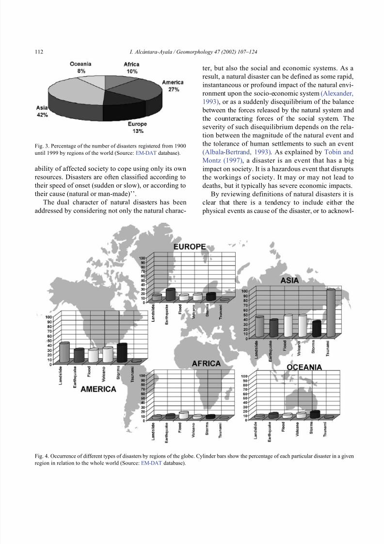
8102019 Articulo - Geomorphology Natural Hazards Vulnerability and Prevention of Natural Disasters in Developing Countrihellip
httpslidepdfcomreaderfullarticulo-geomorphology-natural-hazards-vulnerability-and-prevention-of 618
ability of affected society to cope using only its own
resources Disasters are often classified according to
their speed of onset (sudden or slow) or according to
their cause (natural or man-made)rsquorsquo
The dual character of natural disasters has been
addressed by considering not only the natural charac-
ter but also the social and economic systems As a
result a natural disaster can be defined as some rapid
instantaneous or profound impact of the natural envi-
ronment upon the socio-economic system (Alexander1993) or as a suddenly disequilibrium of the balance
between the forces released by the natural system and
the counteracting forces of the social system The
severity of such disequilibrium depends on the rela-
tion between the magnitude of the natural event and
the tolerance of human settlements to such an event
(Albala-Bertrand 1993) As explained by Tobin and
Montz (1997) a disaster is an event that has a big
impact on society It is a hazardous event that disrupts
the workings of society It may or may not lead to
deaths but it typically has severe economic impacts
By reviewing definitions of natural disasters it is
clear that there is a tendency to include either the
physical events as cause of the disaster or to acknowl-
Fig 3 Percentage of the number of disasters registered from 1900
until 1999 by regions of the world (Source EM-DAT database)
Fig 4 Occurrence of different types of disasters by regions of the globe Cylinder bars show the percentage of each particular disaster in a given
region in relation to the whole world (Source EM-DAT database)
I Alca ntara-Ayala Geomorphology 47 (2002) 107ndash124112
8102019 Articulo - Geomorphology Natural Hazards Vulnerability and Prevention of Natural Disasters in Developing Countrihellip
httpslidepdfcomreaderfullarticulo-geomorphology-natural-hazards-vulnerability-and-prevention-of 718
edge that the social and economic systems take part as
well as nature In some cases the possible consequen-
ces of the natural disasters are stated whereas the
reason why they occur is frequently omitted
32 Where do natural disasters occur
Natural disasters are a global issue as they occur all
over the world (Figs 1 and 2) Even though they may
have a considerable impact in countries such as Japan
USA France or Switzerland their significance in
countries such as Bangladesh India China Guate-
mala Colombia or Mexico is by far greater (Table 1)
The global death toll due to natural disasters is
concentrated in developing countries (also called
Third World Countries) and it can be as high as
95 of the total toll (Alexander 1993)
Most of the developing countries are located in
areas especially prone to natural hazards Volcanism is
associated with specific areas such as the Circum-
Pacific Volcanic Belt where approximately 80 of
the total activity takes place (Anderson and Decker
1992) Many Latin American and Asian countries are
located within this area and the effect volcanism and
its associated risks may cause to the population living
in close proximity is observed in disasters such as the
catastrophe of Nevado del Ruiz in Colombia (21800 people killed)
Asia and Latin America share the highest concen-
tration of flooding and associated risks due to hurri-
canes cyclones tropical storms typhoons and mon-
soons They are also the areas most susceptible to
earthquakes According to the registered natural dis-
asters which occurred between 1900 and 1999 (Fig 3)42 of the total number took place in Asia whereas
America had 27 Europe 13 and Oceania and
Africa 8 and 10 respectively (EM-DAT database
Office of US Foreign Disaster Assistance and the
Centre for Research on the Epidemiology of Disasters
OFDA CRED) The spatial distribution of natural dis-
asters (Fig 4) shows a clear tendency to occur in
developing countries In addition their impact is
reflected given the cost the consequences have in
relation to the GNP GDP and the time needed for
partial or total recovery For instance more than 9000
people lost their lives and about 11 (32 million
people) of the total population in Central America
was affected by the consequences of Hurricane Mitch
The impact was not homogeneous in all the countries
In Honduras the losses were equivalent to 80 of the
1997 GDP whereas those in Nicaragua were almost
49 of GDP The total losses of the whole region were
estimated at US$6 billion (Table 2) having a slightly
larger concentration of direct (515) than the indirect
(485) damage Furthermore the damage to the
population (Table 3) can be barely evaluated in finan-
cial t erms and in relation to the post-disaster recoverytime (CEPAL 1999)
The case of Hurricane Mitch in Central America
shows that even though the susceptibility of these
Table 2
Summary of damage in millions of dollars caused by Hurricane Mitch in Central America (Source CEPAL 1999 based on official figures and
their own estimates)
Total Direct damage Indirect damage Replacement cost
Total sectors 60183 31003 29180 44773
Social sectors 7985 5518 2466 9751
Housing 5909 4363 1546 7463
Health 1327 538 789 1170
Education 749 618 131 1118
Infrastructure 12455 6569 5886 17565
Roads bridges and railways 10695 5281 5415 14279
Energy 587 286 301 606
Water and sewerage systems 914 746 168 2244
Irrigation and drainage 258 256 02 436
Productive sectors 39069 18241 20828 16352
Farming fishing and forestry 29465 17019 12446 13020
Manufacturing industry 6080 328 5752 699
Trade restaurants and hotels 3524 894 2630 2633
Environment 674 674 00 1105
I Alca ntara-Ayala Geomorphology 47 (2002) 107ndash124 113
8102019 Articulo - Geomorphology Natural Hazards Vulnerability and Prevention of Natural Disasters in Developing Countrihellip
httpslidepdfcomreaderfullarticulo-geomorphology-natural-hazards-vulnerability-and-prevention-of 818
countries to natural disasters is high due to the
environmental setting (in a non-deterministic sense)
issues related to the social economic political and
cultural aspects of any social entity play a great role as
factors of vulnerability to natural disasters Although
poverty and natural disasters should not be considered
as synonyms it is certain that some characteristics
resulting from the economicndash socialndash politicalndash cul-
tural system reduce or eliminate equal access to
opportunities and therefore to development These
characteristics increase vulnerability Therefore the
occurrence of natural disasters in developing countries
is not only linked to the susceptibility of natural
hazards due to geologicalndashgeomorphological featuresand geographical location but also due to the vulner-
ability of the system where they exist
An example of the coupling of natural and
human vulnerability by analyzing the 1985 earth-
quake of Mexico City was presented by Blaikie et
al (1994) The city was erected on the bed of an
ancient lake making the soil highly vulnerable to
earthquakes and associated processes such as lique-
faction (natural vulnerability) Construction of build-
ings within the zone was performed using materials
of diverse type and quality during different periodsof time High population density low-income jobs
and poverty contributed to poor housing standards
(social and economic vulnerability) All the elements
derived from the particular natural social and
economic vulnerability of the area were combined
at the time of the earthquake producing zones of
disaster This case and the consequences of hurri-
cane Mitch underpin the need of both types of
vulnerability analysis to better understand and pre-
vent natural disasters
4 Natural disasters and geomorphology
Little has been done to associate geomorphology
and natural disasters directly Few publications in
geomorphology deal specifically with this issue (eg
Okuda 1970 Verstappen 1989 Rosenfeld 1994)
However innumerable works related to natural haz-
ards have represented the significance of geomorphol-
ogy to the natural disaster field Geomorphologists
have been concerned with the understanding analysis
and forecast of hazards such as flooding mass move-
ment earthquakes and volcanism
Flooding associated with hydrometeorological phe-
nomenon namely tropical storms hurricanes mon-soons (Kale et al 1994) El Nino or La Nina is
regarded as one of the most dangerous natural hazards
and principal trigger of disasters Fluvial geomorphol-
ogists have paid considerable attention to flooding
Approaches to understand this process include the
study of past events or palaeoflood geomorphology
and flood hydrology (Enzel et al 1993 Baker 1994
Kale et al 1997) Furthermore flood simulations
(Enzel and Wells 1997 Bates and De Roo 2000
Chang et al 2000) forecasting (Chowdhury 2000)
and flood maps elaborated by using GeographicalInformation Systems (GIS) (Merzi and Aktas 2000)
radar imagery (Zhou et al 2000) and remote sensing
(Islam and Sado 2000 Siegel and Gerth 2000) have
been a crucial aspect in the development of hazard and
risk assessment and management
Based on different approaches such as mapping
(Canuti et al 1987 Leroi 1997 Yin 1994) the
elaboration of inventories (Al-Homoud and Tubeileh
1997 Chacon et al 1996 Guzzetti et al 1994)
analysis of historical archives (Brunsden 1993 Ibsen
Table 3
Population affected by Hurricane Mitch in Central America (Source CEPAL 1999 based on official figures)
Item Total Costa Rica El Salvador Guatemala Honduras Nicaragua
(1) Dead 9214 4 240 268 5657 3045(2) Missing 9171 3 19 121 8058 970
(3) Injured 12842 ndash ndash 280 12275 287
(4) In shelters 466271 5411 55864 54725 285000 65271
(5) Total evacuated and direct victims 1191908 16500 84316 105000 617831 368261
(6) Population directly affected 3464662 20000 346910 730000 1500000 867752
(7) Children under five 1801624 10400 180393 379600 780000 451231
(8) Total population 31648907 3270700 6075536 11645900 6203188 4453583
(9) Percentage affected 109 06 57 63 242 195
I Alca ntara-Ayala Geomorphology 47 (2002) 107ndash124114
8102019 Articulo - Geomorphology Natural Hazards Vulnerability and Prevention of Natural Disasters in Developing Countrihellip
httpslidepdfcomreaderfullarticulo-geomorphology-natural-hazards-vulnerability-and-prevention-of 918
8102019 Articulo - Geomorphology Natural Hazards Vulnerability and Prevention of Natural Disasters in Developing Countrihellip
httpslidepdfcomreaderfullarticulo-geomorphology-natural-hazards-vulnerability-and-prevention-of 1018
panorama of the occurrence of such events and their
consequences
In the geomorphological dimensions of natural
disasters Rosenfeld (1994) examined the contribu-
tions of different geomorphological projects to inter-
disciplinary research including rainfall-induced land-
sliding cyclonic storms flooding etc Certainly the
use of remote sensing Global Positioning System
(GPS) and GIS has led to the incorporation of geo-
morphologists into the mapping analysis and model-
ing of such geophysical hydrological and geomor-
phological processes within the natural and human
hazards approach Rosenfeld illustrated the relation-
ship between the natural and human sides of the
Fig 6 Natural and geomorphology related disasters registered from 1990 to 1999 worldwide (Source EM-DAT database)
Fig 7 Estimated damage due to natural and geomorphology related disasters from 1990 to 1999 (Source EM-DAT database)
I Alca ntara-Ayala Geomorphology 47 (2002) 107ndash124116
8102019 Articulo - Geomorphology Natural Hazards Vulnerability and Prevention of Natural Disasters in Developing Countrihellip
httpslidepdfcomreaderfullarticulo-geomorphology-natural-hazards-vulnerability-and-prevention-of 1118
extent of natural hazards by using a pyramid-form
graph where the faces represent the duration and areal
extents of different hazards in terms of casualties and
hazard severity according to the different degree of
development of the countries and based on the level
response needed to cope with the disasters as a
function of economic development
By analyzing the EM-DAT database which
includes phenomena such as slides floods earth-
quakes volcanoes wind storms extreme tempera-
tures droughts wild fires and epidemics as natural
disasters it can be noticed that with exception of
extreme temperatures and epidemics all the other
ph en omen a are ge omor ph ol ogy rela te d Fig 5
presents the percentage of those disasters related to
geomorphology by type and region from 1900 to
1999 Between 1990 and 1999 2808 disasters were
recorded worldwide Eighty four percent of them wererelated to geomorphology (Fig 6) The total amount
of estimated damage (Fig 7) in relation to the global
natural disasters registered within the same period of
time and the number of people reported killed (Table
4) and affected (Fig 8) give a good indication of the
significance of geomorphology for the prevention of
natural disasters
The contribution of geomorphology to the field of
natural disasters is mainly through the elaboration of
hazard assessments In general such assessments
comprise stages like mapping modeling prediction
and management proposals using field observations
photogrammetry geographical information systems
and remote sensing the zonation and mapping of
different hazards is done Modeling approaches con-
sider not only the understanding of present but past
events leading to accurate predictions of the conse-
quences a geomorphic hazard may have on a deter-
mined landscape under a given conditions
Hazard assessment is a key part within the risk
analysis process Certainly geomorphologists have
contributed enormously on this matter Nevertheless
Table 4
Total number of people reported killed by continent and by type of
phenomenon from 1990 to 1999 (Source EM-DAT database)
Africa Americas Asia Europe Oceania Total
Slides 225 2010 5500 644 279 8658
Droughts 12 0 2680 0 98 2790
Earthquakes 816 3519 91878 2395 70 98678
Floods 9487 35598 55916 2839 30 103870
Wind Storms 1612 13264 185739 913 262 201790
Volcanoes 0 77 994 0 9 1080
Total 12152 54468 342707 6791 748 416866
Fig 8 People affected due to natural and geomorphology related disasters from 1990 to 1999 (Source EM-DAT database)
I Alca ntara-Ayala Geomorphology 47 (2002) 107ndash124 117
8102019 Articulo - Geomorphology Natural Hazards Vulnerability and Prevention of Natural Disasters in Developing Countrihellip
httpslidepdfcomreaderfullarticulo-geomorphology-natural-hazards-vulnerability-and-prevention-of 1218
a greater progress would be achieved if vulnerability
analysis were also taken into account
5 Geomorphology vulnerability and disasters
By examining the different definitions of natural
hazards and natural disasters it is clear that the
conceptualization has changed from a perspective of
a merely physical or natural event towards the inte-
gration of the human system Initially the uncontrol-
lable character of natural hazards directed efforts
towards coping with their impacts and also towards
the prediction of these events Technological advances
and the development of prediction models for vol-
canic activity hurricanes tsunamis flooding land-
sliding etc were developed seeking a better under-
standing of the phenomena and to some extent to offer
possibilities to cope with the impact of natural haz-
ards but mainly in lsquodeveloped countriesrsquo
Later in the 1960s the idea of the devastation by
natural disasters as a result of the social and economic
characteristics of the regions where natural hazards
took place was introduced (White 1961 1964 Kates
1962 Burton et al 1968 Hewitt and Burton 1971)
However it was not until the 1970s that the role of
economic and social conditions as factors of vulner-ability to natural disasters was acknowledged
The interest of understanding not only the natural
events per se but the characteristics of risk in the
areas prone to these phenomena has moved the
attention of many social scientists towards the study
of risk and vulnerability (eg Albala-Bertrand 1993
Blaikie et al 1994 Cannon 1993 Varley 1991
Winchester 1992) Previous investigations have
shown the need for defining and measuring hazard
events in a non-scientific (physical) view This
includes the description and analyses of different perceptions of hazard (Burton et al 1968) based on
the concept of differential perception of risk a very
important factor in the development of risk manage-
ment approaches
At the present time not only social scientists but
geoscientists are considering the socio-economic char-
acter of some regions prone to natural hazards as one
of the main factors of vulnerability to natural disasters
For instance Cardona (1997) considered the social
economic and institutional aspects within the manage-
ment of the crisis of Galer as volcano in Colombia
Dibben and Chester (1999) proposed a framework to
analyze human vulnerability in the case of Furnas
volcano in the Azores They recognized that peoplersquosvulnerability to volcanic hazards implies an interaction
of different elements related to the social context and
the corresponding physiological and psychological
characteristics In his overview of volcanic geomor-
phology Thouret (1999) pointed out that in order to
cope with the consequences of natural hazards and their
interaction with people living around the volcanoes
geomorphology is an essential part to undertake risk
assessment based on geomorphic hazard and risk
zonation
51 A closer look to vulnerability
The study of vulnerability related to natural disas-
ters has been the focus of different investigations and
hence of several definitions Westgate and OrsquoKeefe
(1976) defined vulnerability as the degree to which a
community is at risk from the occurrence of extreme
physical or natural phenomena where risk refers to the
probability of occurrence and the degree to which
socio-economic and socio-political factors affect the
communityrsquos capacity to absorb and recover from
extreme phenomena For Varley (1991) vulnerabilityis a function of the degree of social and self-protection
available to potential victims It is clearly related to the
ability of households or communities to cope with and
recover from outside events and particularly to shocks
and sudden changes (Maskey 1993) It also concerns
the predisposition of a society to experience substan-
tial damage as a result of natural hazards (Clarke and
Munasinghe 1995) These definitions imply that vul-
nerability is the result of the socio-economic and
political systems of the entity in danger However it
is the definition of Cannon (1993) which considersdifferent factors affecting or producing the vulnerabil-
ity of individuals or groups that is most germane
According to him vulnerability lsquolsquois a characteristic of
individuals and groups of people who inhabit a given
natural social and economic space within which they
are differentiated according to their varying position in
society into more or less vulnerable individuals and
groups It is a complex characteristics produced by a
combination of factors derived especially (but not
entirely) from class gender or ethnicityrsquorsquo Cannon
I Alca ntara-Ayala Geomorphology 47 (2002) 107ndash124118
8102019 Articulo - Geomorphology Natural Hazards Vulnerability and Prevention of Natural Disasters in Developing Countrihellip
httpslidepdfcomreaderfullarticulo-geomorphology-natural-hazards-vulnerability-and-prevention-of 1318
divided vulnerability into three parts (1) Livelihood
resilience the degree of resilience of the particular
livelihood system of an individual or group and their
capacity for resisting the impact of hazard (2) Healthincluding both the robustness of individuals and the
operation of various social measures (3) Preparedness
determined by the protection available for a given
hazard something that depends on people acting on
their own behalf and social factors
These three aspects cover a great proportion of the
different kinds of vulnerabilities Nevertheless each
aspect has different components and the combinations
of them can be so numerous that it is necessary to
specify the particular types of vulnerability of each
threatened entity The latter will provide an adequate
understanding of the total vulnerability to natural
disasters so that prevention can be effectively accom-
plished This insight strengthens the contribution of
Aysan (1993) who recognizes different kinds of
vulnerability as follows
Lack of access to resources (materialseconomic
vulnerability) Disintegration of social patterns (social vulnerabil-
ity) Lack of strong national and local institutional
structures (organizational vulnerability) Lack of access to information and knowledge
(educational vulnerability) Lack of public awareness (attitudinal and motiva-
tional vulnerability) Limited access to political power and representa-
tion (political vulnerability) Certain beliefs and customs (cultural vulner-
ability) Weak buildings of weak individuals (physical
vulnerability)
There are indeed many other kinds of vulnerability
However all of them can be inserted within four main
types of vulnerability social economic political and
cultural This classification indicates that each social
entity has different types of vulnerability and it is not
only the result of the human actions decisions and
choices it is the result of the interaction of the natural
economic social cultural and political contexts where
people live Vulnerability cannot be treated as a
homogeneous and general term its dynamism is given
by each society and it is both a universal and
particular concept There is certainly a differential
character of vulnerability Vulnerability is given by
t he coupling between the natural and human systems(Fig 9) In this sense vulnerability can be divided
into natural vulnerability and human vulnerability
Natural vulnerability depends on the threatening nat-
ural hazard (very much related to geographical loca-
tion) thus there is volcanic vulnerability flooding
vulnerability landsliding vulnerability tsunamis vul-
nerability hurricane vulnerability and so on On con-
trast human vulnerability is based on the social
economical political and cultural systems
Hence vulnerability can be defined as the propen-
sity of an endangered element due to any kind of
natural hazard to suffer different degrees of loss or
amount of damage depending on its particular social
economic cultural and political weaknesses Total
vulnerability is a function of the individual types of
vulnerability present in a given area Such vulnerabil-
ity determines the magnitude of the disaster the level
of resilience and the recovery process
52 A step forward into the prevention of natural
disasters applied geomorphology
The reduction of natural vulnerability could beobtained from an equal access to scientific informa-
tional resources and methodologies for the understand-
ing and prediction of natural hazards (eg state-of-art
predicting models) and to international training pro-
grams Natural hazards cannot be prevented but the
understanding of the process and scientific method-
ologies to predict patterns of behavior of such pro-
cesses can be powerful tools to help reduce natural
vulnerability
Geomorphological research can provide theoretical
and applied approaches to the prevention of naturaldisasters in terms of origin and dynamism of the
physical processes Furthermore geomorphologists
could also offer important contributions based on the
understanding of the interaction between natural haz-
ards (natural vulnerability) and the societies (human
vulnerability) Consequently they should be involved
to a greater extent in such tasks as is the case of the
contributions of D Alexander M Panizza and HT
Verstappenmdashto mention the most familiar examplesmdash
who not only have shed light on understanding geo-
I Alca ntara-Ayala Geomorphology 47 (2002) 107ndash124 119
8102019 Articulo - Geomorphology Natural Hazards Vulnerability and Prevention of Natural Disasters in Developing Countrihellip
httpslidepdfcomreaderfullarticulo-geomorphology-natural-hazards-vulnerability-and-prevention-of 1418
morphological processes but also on the strong link
between the processes and society
Geomorphology can be considered a strategic
discipline in the reduction of both human and natural
vulnerabilities By contributing to the understanding
of endogenetic and exogenetic processes method-
ologies to predict patterns of occurrence of hazardous
events can be developed and applied Geomorpholo-
gists assist in the reduction of natural vulnerability inthree different ways first by enriching the theoretical
knowledge of geomorphology which is the base of
the application of our discipline second by develop-
ing prediction models for different processes such as
landsliding flooding volcanism among others and
finally through diversified approaches of applied
geomorphology for the prevention of natural disas-
ters Indeed geomorphology is a powerful field that
must play a role in the interdisciplinary efforts to
develop adequate strategies for prevention and miti-
gation of natural disasters Nonetheless contributions
of geomorphology would be even more significant if
research applications were directed towards the
understanding and coupling of human and natural
vulnerabilities Reduction of natural disasters is a
complex task by nature however it is now clear
that a combination not only of social and scientific
knowledge but also of attitudes towards the elabo-
ration of adequate strategies based on vulnerabilityanalysis of the particular social entities is urgently
required
6 Conclusions
Natural hazards are threatening events capable of
producing damage to the physical and social space in
which they take place not only at the moment of their
occurrence but in the long-term due to their associ-
Fig 9 The ingredients of natural disasters
I Alca ntara-Ayala Geomorphology 47 (2002) 107ndash124120
8102019 Articulo - Geomorphology Natural Hazards Vulnerability and Prevention of Natural Disasters in Developing Countrihellip
httpslidepdfcomreaderfullarticulo-geomorphology-natural-hazards-vulnerability-and-prevention-of 1518
ated consequences When these consequences have an
impact on society andor infrastructure they become
natural disasters These can be considered as sudden
but expected (we all know that they occur) naturalevents which impact the human and natural systems
The degree of their impact in space and time is a
function of the exposure to and the magnitude of the
natural phenomena (natural vulnerability) and the
human vulnerability of the threatened entity
Natural disasters occur all over the world how-
ever their impact in developing countries is greater
due to the geographical location in zones highly
susceptible to natural hazards (natural vulnerability)
and also due to the different types of economic social
political and cultural vulnerabilities that exist These
vulnerabilities are indeed the result of their historical
development and their social political economic and
cultural contexts The rich get richer the poor poorer
and the access to opportunities within the social entity
are unequal and indirectly proportional to the occur-
rence of natural disasters (the less opportunities the
more vulnerability the more affected by natural dis-
asters)
The International Decade for Natural Disaster
Reduction (IDNDR) has achieved several goals such
as the organization of international groups to provide
advice on the prevention of natural disasters onregional and national bases Events such as Hurricane
Mitch in Central America (October 1998) the earth-
quake in Turkey (August 1999) and their devastating
consequences demonstrated that natural disasters
occur in places where the geographical coordinates
of natural and human vulnerabilities converge An
effort must be made to promote the elaboration of
vulnerability analysis within a risk assessment and
management framework where not only geomor-
phology but also geomorphologists play a key role
for the prevention of natural disasters The latter needs indeed to be more rapidly implemented in
developing countries
Acknowledgements
Natural disasters registered data were kindly
provided by the ODFACRED International Disaster
Database Center for Research into the Epidemiology of
Disasters (CRED) Catholic University of Louvain
Belgium (httpwwwmduclacbecred) and the Of-
fice of US Foreign Disaster Assistance (httpwww
usaidgovhum _ responseofda ) Thanks are also due to
BE Montz CL Rosenfeld and PLK Knuepfer for critical reviewing of this paper
References
Albala-Bertrand JM 1993 Political Economy of Large Natural
Disasters With Special Reference to Developing Countries Ox-
ford Univ Press London 259 pp
Alexander D 1993 Natural Disasters UCL Press and Chapman amp
Hall New York 632 pp
Al-Homoud AS Tubeileh T 1997 An inventory for evaluating
hazard and risk assessment of cut slopes in weak rocks along
highways Bull Int Assoc Eng Geol 55 39ndash51Anderson JL Decker RW 1992 Volcano risk mitigation
through training In McCall GJH Laming DJC Scott
SC (Eds) Geohazards Natural and Man-Made Chapman amp
Hall London pp 7 ndash 12
Anderson MG Collison AJC Hartshorne J Lloyd DM
Park A 1996 Developments in slope hydrology-stability mod-
eling for tropical slopes In Anderson MG Brooks SM
(Eds) Advances in Hillslope Processes vol 2 Wiley Chiches-
ter pp 799ndash821
Aysan YF 1993 Vulnerability assessment In Merriman PA
Browitt CWA (Eds) Natural Disasters Protecting Vulnerable
Communities Thomas Telford London pp 1 ndash 14
Baker VR 1994 Geomorphological understanding of floods Geo-
morphology 10 139ndash156
Barkun N 1974 Disaster and the Millenium Yale Univ Press
New Haven
Bates PD De Roo APJ 2000 A simple raster-based model for
flood inundation simulation J Hydrol 236 54ndash77
Blaikie P Cannon T Davis I Wisner B 1994 At Risk Natural
Hazards Peoplersquos Vulnerability and Disasters Routledge Lon-
don 284 pp
Brooks SM Collison AJC 1996 The significance of soil pro-
file differentiation to hydrological response and slope instability
a modeling approach In Anderson MG Brooks SM (Eds)
Advances in Hillslope Processes vol 2 Wiley Chichester pp
471ndash486
Brunsden D 1993 Mass movement the research frontier and bey ond a geomor phological approa ch Geom orp hology 7
85ndash128
Brunsden D 1999 Some geomorphological considerations for the
future development of landslide models Geomorphology 30
13ndash24
Burton I Kates RW 1964 The perception of natural hazards in
resource management Nat Resour J 3 412ndash441
Burton I Kates RW White GF 1968 The Human Ecology of
Extreme Geophysical Events Department of Geography Natu-
ral Hazards Research Working Paper No 1 University of Tor-
onto
Cannon T 1993 A hazard need not a disaster make vulnerability
I Alca ntara-Ayala Geomorphology 47 (2002) 107ndash124 121
8102019 Articulo - Geomorphology Natural Hazards Vulnerability and Prevention of Natural Disasters in Developing Countrihellip
httpslidepdfcomreaderfullarticulo-geomorphology-natural-hazards-vulnerability-and-prevention-of 1618
and the causes of lsquonaturalrsquo disasters In Merriman PA Bro-
witt CWA (Eds) Natural Disasters Protecting Vulnerable
Communities Thomas Telford London pp 92ndash 105
Canuti P Focardi P Garzonia CA Rodolfi G Vannocci P
1987 Slope stability mapping in Tuscany Italy In Gardiner V(Ed) International Geomorphology 1986 Part I Wiley London
pp 231 ndash 240
Cardona OD 1997 Management of the volcanic crises of Galeras
volcano social economic and institutional aspects J Volcanol
Geother Res 77 313ndash324
Carrara A Cardinali M Detti R Guzzetti F Pasqui V Reich-
enbach P 1990 Geographical information systems and multi-
variate models in landslide hazard evaluation In Cancelli A
(Ed) Alps 90 Int Conf and Field Workshop on Landslides
Milano pp 17ndash 28
CEPAL 1999 Central America Assessment of the Damage Caused
by Hurricane Mitch 1998 Implications for Economic and So-
cial Development and for the Environment 41 pp At http
wwwcepalorgmx
Chacon J Irigaray C El Hamdouni R Fernandez T 1996
From the inventory to the risk analisis improvements to a large
scale GIS method In Chacon J Irigaray C Fernandez T
(Eds) Landslides Balkema Rotterdam pp 335ndash342
Chandler JH Brunsden D 1995 Steady state behaviour of the
Black Ven mudslide the application of archival analytical pho-
togrammetry to studies of landform change Earth Surf Pro-
cesses Landf 20 255ndash275
Chandler JH Cooper MAR 1989 The extraction of positional
data from historical photographs and their application in geo-
morphology Photogramm Rec 13 (73) 69 ndash 78
Chandler JH Moore R 1989 Analytical photogrammetry a
method for monitoring slope instability Q J Eng Geol 2297ndash110
Chang TJ Hsu MH Teng WH Huang CJ 2000 A GIS-
assisted distributed watershed model for simulating flooding and
inundation J Am Wat Resour Assoc 36 (5) 975 ndash 988
Chowdhury MR 2000 An assessment of flood forecasting in
Bangladesh the experience of the 1998 flood Nat Hazards
22 (2) 139ndash163
Clarke C Munasinghe M 1995 Economic aspects of disasters
and sustainable development an introduction In Munasinghe
M Clarke C (Eds) Disaster Prevention for Sustainable De-
velopment Economy and Policy Issues IDNDR and the World
Bank Washington pp 1ndash10
Collison AJC Anderson MG 1996 Using a combined slope
hydrology-slope stability model to identify suitable conditionsfor landslide prevention by vegetation in the humid tropics
Earth Surf Processes Landf 21 (8) 737ndash747
Collison AJC Anderson MG Lloyd DM 1995 The impact
of vegetation on slope stability in a humid tropical environment
a modeling approach Inst Civil Eng Water Marit Energy 112
168ndash175
Corominas J Moya J 1996 Historical landslides in the eastern
Pyrenees and their relation to rainy events In Chacon J Iri-
garay C Fernandez T (Eds) Landslides Balkema Rotter-
dam pp 125ndash132
Dibben C Chester DK 1999 Human vulnerability in volcanic
environments the case of Furnas Sao Miguel Azores J Vol-
canol Geother Res 92 (1ndash2) 133ndash150
Dikau R Jaeger S 1993 The role of geomorphology in regional
landslide hazard assessment using GIS technologies In Reich-
enbach P Guzzetti F Carrara A (Eds) Workshop on Geo-graphic Information Systems in Assessing Natural Hazards
Univ Foreigners Perugia Italy pp 54 ndash 55
Dikau R Cavallin A Jaeger S 1992 Database and GIS for
landslide research in Europe In Casale R Fantechi R Flag-
eollet JC (Eds) Temporal Occurrence and Forecasting of
Landslides in the European Community Final Report vol 1
pp 97 ndash 116
Domınguez-Cuesta MJ Jimınez-Sanchez M Rodrıguez-Garcıa
A 1999 Press archives as temporal records of landslides in the
north of Spain relationships between rainfall and instability
slope events Geomorphology 30 125ndash132
Dowdeswell JA Lamb HF Lewin J 1988 Failure and flow on
a 35 degrees slope causes and three-dimensional observations
Earth Surf Processes Landf 13 737ndash746
Elsinga RJ Verstappen HT 1988 SPOT for earthquake hazard
zoning in southern Italy SPOT 1 Image utilization assessment
results Techniques Spatiales 1 Centre National drsquoEtudes Spa-
tiales Toulouse France pp 199ndash207
EM-DAT The OFDACRED International Disaster Database At
httpwwwcredbeemdat Universite Catholique de Louvain
Brussels Belgium
Enzel Y Wells SG 1997 Extracting Holocene paleohydrology
and paleoclimatology information from modern extreme flood
events an example from Southern California Geomorphology
19 203ndash226
Enzel Y Ely LL House PK Baker VR Webb RH 1993
Paleoflood evidence for a natural upper bound to flood magni-tudes in the Colorado River Water Resour Res 29 (7) 2287ndash
2297
Erdik M Biro YA Onur T Sesetyan K Birgoren G 1999
Assessment of earthquake hazard in Turkey and neighboring
regions Ann Geofis 42 1125ndash1138
Fritz CE 1961 Disasters In Merton RK Nisbet RA (Eds)
Contemporary Social Problems Harcourt New York pp 651ndash
694
Galadini F Galli P 2000 Active tectonics in the central Apen-
nines (Italy)mdashinput data for seismic hazard assessment Nat
Hazards 22 (3) 225ndash270
Gares PA Sherman DJ Nordstrom KF 1994 Geomorphology
and natural hazards Geomorphology 10 1ndash18
Gili JA Corominas J Rius J 2000 Using global positioningsystem techniques in landslide monitoring Eng Geol 55 (3)
167ndash192
Gomez-Fernandez F 2000 Contribution of geographical informa-
tion systems to the management of volcanic crises Nat Hazards
21 (2ndash 3) 347ndash 360
Guzzetti F Cardinali M Reichenbach P 1994 The AVI project
a bibliographical and archive inventory of landslides and floods
in Italy Environ Manage 18 (4) 623ndash633
Hansen A 1984 Landslide hazard analysis In Brunsden D
Prior DB (Eds) Slope Instability Wiley Chichester pp
523ndash602
I Alcantara-Ayala Geomorphology 47 (2002) 107ndash124122
8102019 Articulo - Geomorphology Natural Hazards Vulnerability and Prevention of Natural Disasters in Developing Countrihellip
httpslidepdfcomreaderfullarticulo-geomorphology-natural-hazards-vulnerability-and-prevention-of 1718
Hewitt K Burton I 1971 The Hazardousness of a Place A
Regional Ecology of Damaging Events Research Paper No 6
Department of Geography University of Toronto
Hutchinson JN 1992 Landslide Hazard Assessment Proc 6th
Int Symp on Landslides Christchurch New Zealand vol 3 pp 3 ndash 35
Ibsen ML Brunsden D 1996 The nature use and problems of
historical archives for the temporal occurrence of landslides
with specific reference to the south coast of Britain Ventnor
Isle of Wight Geomorphology 15 241ndash258
IDNDR 1992 Glossary Internationally Agreed Glossary of Basic
Terms Related to Disaster Management DHA-Geneva 83 pp
Islam MDM Sado K 2000 Development of flood hazard maps
of Bangladesh using NOAA-AVHRR images with GIS Hydrol
Sci J 45 337ndash355
Jenkins A Ashworth PJ Ferguson RI Grieve IC Rowling
P Stott TA 1988 Slope failures in the Ochil Hills Scotland
November 1984 Earth Surf Processes Landf 13 69 ndash 76
Kale VS Ely LL Enzel Y Baker VR 1994 Geomorphic and
hydrologic aspects of monsoon floods on the Narmada and Tapi
Rivers in central India Geomorphology 10 157ndash168
Kale VS Hire P Baker VR 1997 Flood hydrology and geo-
morphology of monsoon-dominated rivers the Indian Peninsu-
la Water Int 22 259ndash265
Kates RW 1962 Hazard and Choice Perception in Flood Plain
Management Research Paper No 78 Department of Geogra-
phy University of Chicago
Leroi E 1997 Landslide risk mapping problems limitations and
developments In Cruden DM Fell R (Eds) Landslide Risk
Assessment Balkema Rotterdam pp 239 ndash 250
Mantovani F Soeters R Van Westen CJ 1996 Remote sensing
techniques for landslide studies and hazard zonation in EuropeGeomorphology 15 213ndash225
Maskey A 1993 Vulnerability accumulation in peripheral regions
in Latin America the challenge for disaster prevention and
management In Merriman PA Browitt CWA (Eds) Nat-
ural Disasters Protecting Vulnerable Communities Thomas
Telford London pp 461ndash472
Merzi N Aktas MT 2000 Geographic information systems
(GIS) for the determination of inundation maps of Lake Mogan
Turkey Water Int 25 (3) 474ndash480
Montgomery DR Dietrich WE 1994 A physically based model
for the topographic control on shallow landsliding Water Re-
sour Res 30 (4) 1153ndash1171
Okuda S 1970 On the relation between physical geomorphology
and the science of natural disasters Bull Disaster Prev ResInst 19 (25) Part 5 Kyoto Japan
Ordaz M Reyes C 1999 Earthquake hazard in Mexico City
observations versus computations Bull Seismol Soc Am 89
(5) 1379ndash 1383
Panizza M 1981 Geomorphology and earthquake hazard in envi-
ronmental planning In Palmentola G Acquafredda P (Eds)
Proceedings of the International Conference on Seismic Zones
in the Mediterranean Area Basilicata Italy pp 203ndash207
Panizza M 1991 Geomorphology and seismic risk Earth-Sci
Rev 31 (1) 11ndash20
Pareschi MT Cavarra L Favalli M Giannini F Meriggi A
2000 GIS and volcanic risk management Nat Hazards 21 (2ndash
3) 361ndash379
Petley DN 1998 Geomorphological mapping for hazard assess-
ment in a neotectonic terrain Geogr J 164 (7) 183ndash201
Proske H 1996 GIS supported analysis of effects of joint systemson shallow landslides in a tectonically complex crystalline
catchment area In Chacon J Irigaray C Fernandez T
(Eds) Landslides Balkema Rotterdam pp 173ndash180
Rosenfeld CL 1994 The geomorphological dimensions of natural
disasters Geomorphology 10 27ndash36
Scheidegger AE 1994 Hazards singularities in geomorphic sys-
tems Geomorphology 10 19ndash25
Siegel H Gerth M 2000 Satellite-based studies of the 1997 Oder
flood event in the southern Baltic Sea Remote Sens Environ
73 (2) 207ndash217
Singhroy V Mattar KE Gray AL 1998 Landslide character-
isation in Canada using interferometric SAR and combined SAR
and TM images Adv Space Res 21 (3) 465ndash476
Slaymaker O 1996 Introduction In Slaymaker O (Ed) Geo-
morphic Hazards Wiley Chichester pp 1ndash7
Sousa J Voight B 1992 Computational flow modeling for long-
runout landslide hazard assessment with an example from Cla-
piere landslide France Bull Assoc Eng Geol 29 (2) 131 ndash
150
Summerfield MA 1991 Global Geomorphology An Introduction
to the Study of Landforms Wiley New York 537 pp
Terlien MTJ 1996 The prediction of rainfall-triggered soil slips
in Manizales (Colombia) In Chacon J Irigaray C Fernan-
dez T (Eds) Landslides Balkema Rotterdam pp 197 ndash 205
Thornes JB Alcantara-Ayala I 1998 Modelling mass failure in a
Mediterranean mountain environment climatic geological
topographical and erosional controls Geomorphology 24 87ndash 100
Thouret JC 1999 Urban hazards and risks consequences of
earthquakes and volcanic eruptions an introduction GeoJournal
49 (2) 131ndash135
Tobin GA Montz BE 1997 Natural Hazards Explanation and
Integration The Guilford Press New York 388 pp
UNDRO 1982 Natural Disasters and Vulnerability Analysis Of-
fice of the United Nations Disaster Relief Coordinator Geneva
Switzerland
Van Asch TWJ Buma JT 1997 Modelling groundwater fluc-
tuations and the frequency of movement of a landslide in the
Terres Noires region of Barcelonnette (France) Earth Surf Pro-
cesses Landf 22 131ndash141
Varley A 1991 Disasters vulnerability and response Disasters 15(3) 285ndash287
Verstappen HT 1988 Geomorphological surveys and natural haz-
ard zoning with special reference to volcanic hazards in central
Java Z Geomorphol Supplbd 68 81ndash101
Verstappen HT 1989 Geomorphology natural disasters and glob-
al change Symposium on Aerospace Survey and Natural Dis-
asters ITC J (3ndash4) 159ndash164
Verstappen HT 1992 Volcanic hazards in Colombia and Indone-
sia lahars and related phenomena In McCall GJH Laming
DDC Scott SC (Eds) Geohazards Natural and Man-Made
Chapman amp Hall London pp 33ndash42
I Alcantara-Ayala Geomorphology 47 (2002) 107ndash124 123
8102019 Articulo - Geomorphology Natural Hazards Vulnerability and Prevention of Natural Disasters in Developing Countrihellip
httpslidepdfcomreaderfullarticulo-geomorphology-natural-hazards-vulnerability-and-prevention-of 1818
Westgate KN OrsquoKeefe P 1976 Some Definitions of Disaster
Disaster Research Unit Occasional Paper No 4 Department of
Geography University of Bradford
White GF (Ed) 1961 Papers on Flood Problems Research Pa-
pers No 70 Department of Geography University of ChicagoWhite GF 1964 Choice of Adjustments to Floods Research Pa-
per No 93 Department of Geography University of Chicago
White GF 1973 Natural hazards research In Chorley RJ (Ed)
Directions in Geography Methuen London pp 193 ndash 216
Winchester P 1992 Power Choice and Vulnerability A Case
Study in Disaster Management in South India James amp James
London 225 pp
Wolman MG Miller JP 1960 Magnitude and frequency of
forces in geomorphic processes J Geol 68 (1) 54ndash74
Yin KL 1994 A computer-assisted mapping of landslide hazardevaluation 7th International IAEG Congress Balkema Rotter-
dam pp 4495ndash 4499
Zhou CH Luo JC Yang CJ Li BL Wang SL 2000 Flood
monitoring using multi-temporal AVHRR and RADARSAT im-
agery Photogramm Eng Remote Sensing 66 (5) 633ndash638
I Alca ntara-Ayala Geomorphology 47 (2002) 107ndash124124
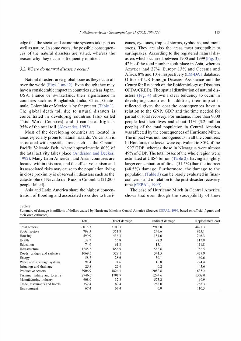
8102019 Articulo - Geomorphology Natural Hazards Vulnerability and Prevention of Natural Disasters in Developing Countrihellip
httpslidepdfcomreaderfullarticulo-geomorphology-natural-hazards-vulnerability-and-prevention-of 718
edge that the social and economic systems take part as
well as nature In some cases the possible consequen-
ces of the natural disasters are stated whereas the
reason why they occur is frequently omitted
32 Where do natural disasters occur
Natural disasters are a global issue as they occur all
over the world (Figs 1 and 2) Even though they may
have a considerable impact in countries such as Japan
USA France or Switzerland their significance in
countries such as Bangladesh India China Guate-
mala Colombia or Mexico is by far greater (Table 1)
The global death toll due to natural disasters is
concentrated in developing countries (also called
Third World Countries) and it can be as high as
95 of the total toll (Alexander 1993)
Most of the developing countries are located in
areas especially prone to natural hazards Volcanism is
associated with specific areas such as the Circum-
Pacific Volcanic Belt where approximately 80 of
the total activity takes place (Anderson and Decker
1992) Many Latin American and Asian countries are
located within this area and the effect volcanism and
its associated risks may cause to the population living
in close proximity is observed in disasters such as the
catastrophe of Nevado del Ruiz in Colombia (21800 people killed)
Asia and Latin America share the highest concen-
tration of flooding and associated risks due to hurri-
canes cyclones tropical storms typhoons and mon-
soons They are also the areas most susceptible to
earthquakes According to the registered natural dis-
asters which occurred between 1900 and 1999 (Fig 3)42 of the total number took place in Asia whereas
America had 27 Europe 13 and Oceania and
Africa 8 and 10 respectively (EM-DAT database
Office of US Foreign Disaster Assistance and the
Centre for Research on the Epidemiology of Disasters
OFDA CRED) The spatial distribution of natural dis-
asters (Fig 4) shows a clear tendency to occur in
developing countries In addition their impact is
reflected given the cost the consequences have in
relation to the GNP GDP and the time needed for
partial or total recovery For instance more than 9000
people lost their lives and about 11 (32 million
people) of the total population in Central America
was affected by the consequences of Hurricane Mitch
The impact was not homogeneous in all the countries
In Honduras the losses were equivalent to 80 of the
1997 GDP whereas those in Nicaragua were almost
49 of GDP The total losses of the whole region were
estimated at US$6 billion (Table 2) having a slightly
larger concentration of direct (515) than the indirect
(485) damage Furthermore the damage to the
population (Table 3) can be barely evaluated in finan-
cial t erms and in relation to the post-disaster recoverytime (CEPAL 1999)
The case of Hurricane Mitch in Central America
shows that even though the susceptibility of these
Table 2
Summary of damage in millions of dollars caused by Hurricane Mitch in Central America (Source CEPAL 1999 based on official figures and
their own estimates)
Total Direct damage Indirect damage Replacement cost
Total sectors 60183 31003 29180 44773
Social sectors 7985 5518 2466 9751
Housing 5909 4363 1546 7463
Health 1327 538 789 1170
Education 749 618 131 1118
Infrastructure 12455 6569 5886 17565
Roads bridges and railways 10695 5281 5415 14279
Energy 587 286 301 606
Water and sewerage systems 914 746 168 2244
Irrigation and drainage 258 256 02 436
Productive sectors 39069 18241 20828 16352
Farming fishing and forestry 29465 17019 12446 13020
Manufacturing industry 6080 328 5752 699
Trade restaurants and hotels 3524 894 2630 2633
Environment 674 674 00 1105
I Alca ntara-Ayala Geomorphology 47 (2002) 107ndash124 113
8102019 Articulo - Geomorphology Natural Hazards Vulnerability and Prevention of Natural Disasters in Developing Countrihellip
httpslidepdfcomreaderfullarticulo-geomorphology-natural-hazards-vulnerability-and-prevention-of 818
countries to natural disasters is high due to the
environmental setting (in a non-deterministic sense)
issues related to the social economic political and
cultural aspects of any social entity play a great role as
factors of vulnerability to natural disasters Although
poverty and natural disasters should not be considered
as synonyms it is certain that some characteristics
resulting from the economicndash socialndash politicalndash cul-
tural system reduce or eliminate equal access to
opportunities and therefore to development These
characteristics increase vulnerability Therefore the
occurrence of natural disasters in developing countries
is not only linked to the susceptibility of natural
hazards due to geologicalndashgeomorphological featuresand geographical location but also due to the vulner-
ability of the system where they exist
An example of the coupling of natural and
human vulnerability by analyzing the 1985 earth-
quake of Mexico City was presented by Blaikie et
al (1994) The city was erected on the bed of an
ancient lake making the soil highly vulnerable to
earthquakes and associated processes such as lique-
faction (natural vulnerability) Construction of build-
ings within the zone was performed using materials
of diverse type and quality during different periodsof time High population density low-income jobs
and poverty contributed to poor housing standards
(social and economic vulnerability) All the elements
derived from the particular natural social and
economic vulnerability of the area were combined
at the time of the earthquake producing zones of
disaster This case and the consequences of hurri-
cane Mitch underpin the need of both types of
vulnerability analysis to better understand and pre-
vent natural disasters
4 Natural disasters and geomorphology
Little has been done to associate geomorphology
and natural disasters directly Few publications in
geomorphology deal specifically with this issue (eg
Okuda 1970 Verstappen 1989 Rosenfeld 1994)
However innumerable works related to natural haz-
ards have represented the significance of geomorphol-
ogy to the natural disaster field Geomorphologists
have been concerned with the understanding analysis
and forecast of hazards such as flooding mass move-
ment earthquakes and volcanism
Flooding associated with hydrometeorological phe-
nomenon namely tropical storms hurricanes mon-soons (Kale et al 1994) El Nino or La Nina is
regarded as one of the most dangerous natural hazards
and principal trigger of disasters Fluvial geomorphol-
ogists have paid considerable attention to flooding
Approaches to understand this process include the
study of past events or palaeoflood geomorphology
and flood hydrology (Enzel et al 1993 Baker 1994
Kale et al 1997) Furthermore flood simulations
(Enzel and Wells 1997 Bates and De Roo 2000
Chang et al 2000) forecasting (Chowdhury 2000)
and flood maps elaborated by using GeographicalInformation Systems (GIS) (Merzi and Aktas 2000)
radar imagery (Zhou et al 2000) and remote sensing
(Islam and Sado 2000 Siegel and Gerth 2000) have
been a crucial aspect in the development of hazard and
risk assessment and management
Based on different approaches such as mapping
(Canuti et al 1987 Leroi 1997 Yin 1994) the
elaboration of inventories (Al-Homoud and Tubeileh
1997 Chacon et al 1996 Guzzetti et al 1994)
analysis of historical archives (Brunsden 1993 Ibsen
Table 3
Population affected by Hurricane Mitch in Central America (Source CEPAL 1999 based on official figures)
Item Total Costa Rica El Salvador Guatemala Honduras Nicaragua
(1) Dead 9214 4 240 268 5657 3045(2) Missing 9171 3 19 121 8058 970
(3) Injured 12842 ndash ndash 280 12275 287
(4) In shelters 466271 5411 55864 54725 285000 65271
(5) Total evacuated and direct victims 1191908 16500 84316 105000 617831 368261
(6) Population directly affected 3464662 20000 346910 730000 1500000 867752
(7) Children under five 1801624 10400 180393 379600 780000 451231
(8) Total population 31648907 3270700 6075536 11645900 6203188 4453583
(9) Percentage affected 109 06 57 63 242 195
I Alca ntara-Ayala Geomorphology 47 (2002) 107ndash124114
8102019 Articulo - Geomorphology Natural Hazards Vulnerability and Prevention of Natural Disasters in Developing Countrihellip
httpslidepdfcomreaderfullarticulo-geomorphology-natural-hazards-vulnerability-and-prevention-of 918
8102019 Articulo - Geomorphology Natural Hazards Vulnerability and Prevention of Natural Disasters in Developing Countrihellip
httpslidepdfcomreaderfullarticulo-geomorphology-natural-hazards-vulnerability-and-prevention-of 1018
panorama of the occurrence of such events and their
consequences
In the geomorphological dimensions of natural
disasters Rosenfeld (1994) examined the contribu-
tions of different geomorphological projects to inter-
disciplinary research including rainfall-induced land-
sliding cyclonic storms flooding etc Certainly the
use of remote sensing Global Positioning System
(GPS) and GIS has led to the incorporation of geo-
morphologists into the mapping analysis and model-
ing of such geophysical hydrological and geomor-
phological processes within the natural and human
hazards approach Rosenfeld illustrated the relation-
ship between the natural and human sides of the
Fig 6 Natural and geomorphology related disasters registered from 1990 to 1999 worldwide (Source EM-DAT database)
Fig 7 Estimated damage due to natural and geomorphology related disasters from 1990 to 1999 (Source EM-DAT database)
I Alca ntara-Ayala Geomorphology 47 (2002) 107ndash124116
8102019 Articulo - Geomorphology Natural Hazards Vulnerability and Prevention of Natural Disasters in Developing Countrihellip
httpslidepdfcomreaderfullarticulo-geomorphology-natural-hazards-vulnerability-and-prevention-of 1118
extent of natural hazards by using a pyramid-form
graph where the faces represent the duration and areal
extents of different hazards in terms of casualties and
hazard severity according to the different degree of
development of the countries and based on the level
response needed to cope with the disasters as a
function of economic development
By analyzing the EM-DAT database which
includes phenomena such as slides floods earth-
quakes volcanoes wind storms extreme tempera-
tures droughts wild fires and epidemics as natural
disasters it can be noticed that with exception of
extreme temperatures and epidemics all the other
ph en omen a are ge omor ph ol ogy rela te d Fig 5
presents the percentage of those disasters related to
geomorphology by type and region from 1900 to
1999 Between 1990 and 1999 2808 disasters were
recorded worldwide Eighty four percent of them wererelated to geomorphology (Fig 6) The total amount
of estimated damage (Fig 7) in relation to the global
natural disasters registered within the same period of
time and the number of people reported killed (Table
4) and affected (Fig 8) give a good indication of the
significance of geomorphology for the prevention of
natural disasters
The contribution of geomorphology to the field of
natural disasters is mainly through the elaboration of
hazard assessments In general such assessments
comprise stages like mapping modeling prediction
and management proposals using field observations
photogrammetry geographical information systems
and remote sensing the zonation and mapping of
different hazards is done Modeling approaches con-
sider not only the understanding of present but past
events leading to accurate predictions of the conse-
quences a geomorphic hazard may have on a deter-
mined landscape under a given conditions
Hazard assessment is a key part within the risk
analysis process Certainly geomorphologists have
contributed enormously on this matter Nevertheless
Table 4
Total number of people reported killed by continent and by type of
phenomenon from 1990 to 1999 (Source EM-DAT database)
Africa Americas Asia Europe Oceania Total
Slides 225 2010 5500 644 279 8658
Droughts 12 0 2680 0 98 2790
Earthquakes 816 3519 91878 2395 70 98678
Floods 9487 35598 55916 2839 30 103870
Wind Storms 1612 13264 185739 913 262 201790
Volcanoes 0 77 994 0 9 1080
Total 12152 54468 342707 6791 748 416866
Fig 8 People affected due to natural and geomorphology related disasters from 1990 to 1999 (Source EM-DAT database)
I Alca ntara-Ayala Geomorphology 47 (2002) 107ndash124 117
8102019 Articulo - Geomorphology Natural Hazards Vulnerability and Prevention of Natural Disasters in Developing Countrihellip
httpslidepdfcomreaderfullarticulo-geomorphology-natural-hazards-vulnerability-and-prevention-of 1218
a greater progress would be achieved if vulnerability
analysis were also taken into account
5 Geomorphology vulnerability and disasters
By examining the different definitions of natural
hazards and natural disasters it is clear that the
conceptualization has changed from a perspective of
a merely physical or natural event towards the inte-
gration of the human system Initially the uncontrol-
lable character of natural hazards directed efforts
towards coping with their impacts and also towards
the prediction of these events Technological advances
and the development of prediction models for vol-
canic activity hurricanes tsunamis flooding land-
sliding etc were developed seeking a better under-
standing of the phenomena and to some extent to offer
possibilities to cope with the impact of natural haz-
ards but mainly in lsquodeveloped countriesrsquo
Later in the 1960s the idea of the devastation by
natural disasters as a result of the social and economic
characteristics of the regions where natural hazards
took place was introduced (White 1961 1964 Kates
1962 Burton et al 1968 Hewitt and Burton 1971)
However it was not until the 1970s that the role of
economic and social conditions as factors of vulner-ability to natural disasters was acknowledged
The interest of understanding not only the natural
events per se but the characteristics of risk in the
areas prone to these phenomena has moved the
attention of many social scientists towards the study
of risk and vulnerability (eg Albala-Bertrand 1993
Blaikie et al 1994 Cannon 1993 Varley 1991
Winchester 1992) Previous investigations have
shown the need for defining and measuring hazard
events in a non-scientific (physical) view This
includes the description and analyses of different perceptions of hazard (Burton et al 1968) based on
the concept of differential perception of risk a very
important factor in the development of risk manage-
ment approaches
At the present time not only social scientists but
geoscientists are considering the socio-economic char-
acter of some regions prone to natural hazards as one
of the main factors of vulnerability to natural disasters
For instance Cardona (1997) considered the social
economic and institutional aspects within the manage-
ment of the crisis of Galer as volcano in Colombia
Dibben and Chester (1999) proposed a framework to
analyze human vulnerability in the case of Furnas
volcano in the Azores They recognized that peoplersquosvulnerability to volcanic hazards implies an interaction
of different elements related to the social context and
the corresponding physiological and psychological
characteristics In his overview of volcanic geomor-
phology Thouret (1999) pointed out that in order to
cope with the consequences of natural hazards and their
interaction with people living around the volcanoes
geomorphology is an essential part to undertake risk
assessment based on geomorphic hazard and risk
zonation
51 A closer look to vulnerability
The study of vulnerability related to natural disas-
ters has been the focus of different investigations and
hence of several definitions Westgate and OrsquoKeefe
(1976) defined vulnerability as the degree to which a
community is at risk from the occurrence of extreme
physical or natural phenomena where risk refers to the
probability of occurrence and the degree to which
socio-economic and socio-political factors affect the
communityrsquos capacity to absorb and recover from
extreme phenomena For Varley (1991) vulnerabilityis a function of the degree of social and self-protection
available to potential victims It is clearly related to the
ability of households or communities to cope with and
recover from outside events and particularly to shocks
and sudden changes (Maskey 1993) It also concerns
the predisposition of a society to experience substan-
tial damage as a result of natural hazards (Clarke and
Munasinghe 1995) These definitions imply that vul-
nerability is the result of the socio-economic and
political systems of the entity in danger However it
is the definition of Cannon (1993) which considersdifferent factors affecting or producing the vulnerabil-
ity of individuals or groups that is most germane
According to him vulnerability lsquolsquois a characteristic of
individuals and groups of people who inhabit a given
natural social and economic space within which they
are differentiated according to their varying position in
society into more or less vulnerable individuals and
groups It is a complex characteristics produced by a
combination of factors derived especially (but not
entirely) from class gender or ethnicityrsquorsquo Cannon
I Alca ntara-Ayala Geomorphology 47 (2002) 107ndash124118
8102019 Articulo - Geomorphology Natural Hazards Vulnerability and Prevention of Natural Disasters in Developing Countrihellip
httpslidepdfcomreaderfullarticulo-geomorphology-natural-hazards-vulnerability-and-prevention-of 1318
divided vulnerability into three parts (1) Livelihood
resilience the degree of resilience of the particular
livelihood system of an individual or group and their
capacity for resisting the impact of hazard (2) Healthincluding both the robustness of individuals and the
operation of various social measures (3) Preparedness
determined by the protection available for a given
hazard something that depends on people acting on
their own behalf and social factors
These three aspects cover a great proportion of the
different kinds of vulnerabilities Nevertheless each
aspect has different components and the combinations
of them can be so numerous that it is necessary to
specify the particular types of vulnerability of each
threatened entity The latter will provide an adequate
understanding of the total vulnerability to natural
disasters so that prevention can be effectively accom-
plished This insight strengthens the contribution of
Aysan (1993) who recognizes different kinds of
vulnerability as follows
Lack of access to resources (materialseconomic
vulnerability) Disintegration of social patterns (social vulnerabil-
ity) Lack of strong national and local institutional
structures (organizational vulnerability) Lack of access to information and knowledge
(educational vulnerability) Lack of public awareness (attitudinal and motiva-
tional vulnerability) Limited access to political power and representa-
tion (political vulnerability) Certain beliefs and customs (cultural vulner-
ability) Weak buildings of weak individuals (physical
vulnerability)
There are indeed many other kinds of vulnerability
However all of them can be inserted within four main
types of vulnerability social economic political and
cultural This classification indicates that each social
entity has different types of vulnerability and it is not
only the result of the human actions decisions and
choices it is the result of the interaction of the natural
economic social cultural and political contexts where
people live Vulnerability cannot be treated as a
homogeneous and general term its dynamism is given
by each society and it is both a universal and
particular concept There is certainly a differential
character of vulnerability Vulnerability is given by
t he coupling between the natural and human systems(Fig 9) In this sense vulnerability can be divided
into natural vulnerability and human vulnerability
Natural vulnerability depends on the threatening nat-
ural hazard (very much related to geographical loca-
tion) thus there is volcanic vulnerability flooding
vulnerability landsliding vulnerability tsunamis vul-
nerability hurricane vulnerability and so on On con-
trast human vulnerability is based on the social
economical political and cultural systems
Hence vulnerability can be defined as the propen-
sity of an endangered element due to any kind of
natural hazard to suffer different degrees of loss or
amount of damage depending on its particular social
economic cultural and political weaknesses Total
vulnerability is a function of the individual types of
vulnerability present in a given area Such vulnerabil-
ity determines the magnitude of the disaster the level
of resilience and the recovery process
52 A step forward into the prevention of natural
disasters applied geomorphology
The reduction of natural vulnerability could beobtained from an equal access to scientific informa-
tional resources and methodologies for the understand-
ing and prediction of natural hazards (eg state-of-art
predicting models) and to international training pro-
grams Natural hazards cannot be prevented but the
understanding of the process and scientific method-
ologies to predict patterns of behavior of such pro-
cesses can be powerful tools to help reduce natural
vulnerability
Geomorphological research can provide theoretical
and applied approaches to the prevention of naturaldisasters in terms of origin and dynamism of the
physical processes Furthermore geomorphologists
could also offer important contributions based on the
understanding of the interaction between natural haz-
ards (natural vulnerability) and the societies (human
vulnerability) Consequently they should be involved
to a greater extent in such tasks as is the case of the
contributions of D Alexander M Panizza and HT
Verstappenmdashto mention the most familiar examplesmdash
who not only have shed light on understanding geo-
I Alca ntara-Ayala Geomorphology 47 (2002) 107ndash124 119
8102019 Articulo - Geomorphology Natural Hazards Vulnerability and Prevention of Natural Disasters in Developing Countrihellip
httpslidepdfcomreaderfullarticulo-geomorphology-natural-hazards-vulnerability-and-prevention-of 1418
morphological processes but also on the strong link
between the processes and society
Geomorphology can be considered a strategic
discipline in the reduction of both human and natural
vulnerabilities By contributing to the understanding
of endogenetic and exogenetic processes method-
ologies to predict patterns of occurrence of hazardous
events can be developed and applied Geomorpholo-
gists assist in the reduction of natural vulnerability inthree different ways first by enriching the theoretical
knowledge of geomorphology which is the base of
the application of our discipline second by develop-
ing prediction models for different processes such as
landsliding flooding volcanism among others and
finally through diversified approaches of applied
geomorphology for the prevention of natural disas-
ters Indeed geomorphology is a powerful field that
must play a role in the interdisciplinary efforts to
develop adequate strategies for prevention and miti-
gation of natural disasters Nonetheless contributions
of geomorphology would be even more significant if
research applications were directed towards the
understanding and coupling of human and natural
vulnerabilities Reduction of natural disasters is a
complex task by nature however it is now clear
that a combination not only of social and scientific
knowledge but also of attitudes towards the elabo-
ration of adequate strategies based on vulnerabilityanalysis of the particular social entities is urgently
required
6 Conclusions
Natural hazards are threatening events capable of
producing damage to the physical and social space in
which they take place not only at the moment of their
occurrence but in the long-term due to their associ-
Fig 9 The ingredients of natural disasters
I Alca ntara-Ayala Geomorphology 47 (2002) 107ndash124120
8102019 Articulo - Geomorphology Natural Hazards Vulnerability and Prevention of Natural Disasters in Developing Countrihellip
httpslidepdfcomreaderfullarticulo-geomorphology-natural-hazards-vulnerability-and-prevention-of 1518
ated consequences When these consequences have an
impact on society andor infrastructure they become
natural disasters These can be considered as sudden
but expected (we all know that they occur) naturalevents which impact the human and natural systems
The degree of their impact in space and time is a
function of the exposure to and the magnitude of the
natural phenomena (natural vulnerability) and the
human vulnerability of the threatened entity
Natural disasters occur all over the world how-
ever their impact in developing countries is greater
due to the geographical location in zones highly
susceptible to natural hazards (natural vulnerability)
and also due to the different types of economic social
political and cultural vulnerabilities that exist These
vulnerabilities are indeed the result of their historical
development and their social political economic and
cultural contexts The rich get richer the poor poorer
and the access to opportunities within the social entity
are unequal and indirectly proportional to the occur-
rence of natural disasters (the less opportunities the
more vulnerability the more affected by natural dis-
asters)
The International Decade for Natural Disaster
Reduction (IDNDR) has achieved several goals such
as the organization of international groups to provide
advice on the prevention of natural disasters onregional and national bases Events such as Hurricane
Mitch in Central America (October 1998) the earth-
quake in Turkey (August 1999) and their devastating
consequences demonstrated that natural disasters
occur in places where the geographical coordinates
of natural and human vulnerabilities converge An
effort must be made to promote the elaboration of
vulnerability analysis within a risk assessment and
management framework where not only geomor-
phology but also geomorphologists play a key role
for the prevention of natural disasters The latter needs indeed to be more rapidly implemented in
developing countries
Acknowledgements
Natural disasters registered data were kindly
provided by the ODFACRED International Disaster
Database Center for Research into the Epidemiology of
Disasters (CRED) Catholic University of Louvain
Belgium (httpwwwmduclacbecred) and the Of-
fice of US Foreign Disaster Assistance (httpwww
usaidgovhum _ responseofda ) Thanks are also due to
BE Montz CL Rosenfeld and PLK Knuepfer for critical reviewing of this paper
References
Albala-Bertrand JM 1993 Political Economy of Large Natural
Disasters With Special Reference to Developing Countries Ox-
ford Univ Press London 259 pp
Alexander D 1993 Natural Disasters UCL Press and Chapman amp
Hall New York 632 pp
Al-Homoud AS Tubeileh T 1997 An inventory for evaluating
hazard and risk assessment of cut slopes in weak rocks along
highways Bull Int Assoc Eng Geol 55 39ndash51Anderson JL Decker RW 1992 Volcano risk mitigation
through training In McCall GJH Laming DJC Scott
SC (Eds) Geohazards Natural and Man-Made Chapman amp
Hall London pp 7 ndash 12
Anderson MG Collison AJC Hartshorne J Lloyd DM
Park A 1996 Developments in slope hydrology-stability mod-
eling for tropical slopes In Anderson MG Brooks SM
(Eds) Advances in Hillslope Processes vol 2 Wiley Chiches-
ter pp 799ndash821
Aysan YF 1993 Vulnerability assessment In Merriman PA
Browitt CWA (Eds) Natural Disasters Protecting Vulnerable
Communities Thomas Telford London pp 1 ndash 14
Baker VR 1994 Geomorphological understanding of floods Geo-
morphology 10 139ndash156
Barkun N 1974 Disaster and the Millenium Yale Univ Press
New Haven
Bates PD De Roo APJ 2000 A simple raster-based model for
flood inundation simulation J Hydrol 236 54ndash77
Blaikie P Cannon T Davis I Wisner B 1994 At Risk Natural
Hazards Peoplersquos Vulnerability and Disasters Routledge Lon-
don 284 pp
Brooks SM Collison AJC 1996 The significance of soil pro-
file differentiation to hydrological response and slope instability
a modeling approach In Anderson MG Brooks SM (Eds)
Advances in Hillslope Processes vol 2 Wiley Chichester pp
471ndash486
Brunsden D 1993 Mass movement the research frontier and bey ond a geomor phological approa ch Geom orp hology 7
85ndash128
Brunsden D 1999 Some geomorphological considerations for the
future development of landslide models Geomorphology 30
13ndash24
Burton I Kates RW 1964 The perception of natural hazards in
resource management Nat Resour J 3 412ndash441
Burton I Kates RW White GF 1968 The Human Ecology of
Extreme Geophysical Events Department of Geography Natu-
ral Hazards Research Working Paper No 1 University of Tor-
onto
Cannon T 1993 A hazard need not a disaster make vulnerability
I Alca ntara-Ayala Geomorphology 47 (2002) 107ndash124 121
8102019 Articulo - Geomorphology Natural Hazards Vulnerability and Prevention of Natural Disasters in Developing Countrihellip
httpslidepdfcomreaderfullarticulo-geomorphology-natural-hazards-vulnerability-and-prevention-of 1618
and the causes of lsquonaturalrsquo disasters In Merriman PA Bro-
witt CWA (Eds) Natural Disasters Protecting Vulnerable
Communities Thomas Telford London pp 92ndash 105
Canuti P Focardi P Garzonia CA Rodolfi G Vannocci P
1987 Slope stability mapping in Tuscany Italy In Gardiner V(Ed) International Geomorphology 1986 Part I Wiley London
pp 231 ndash 240
Cardona OD 1997 Management of the volcanic crises of Galeras
volcano social economic and institutional aspects J Volcanol
Geother Res 77 313ndash324
Carrara A Cardinali M Detti R Guzzetti F Pasqui V Reich-
enbach P 1990 Geographical information systems and multi-
variate models in landslide hazard evaluation In Cancelli A
(Ed) Alps 90 Int Conf and Field Workshop on Landslides
Milano pp 17ndash 28
CEPAL 1999 Central America Assessment of the Damage Caused
by Hurricane Mitch 1998 Implications for Economic and So-
cial Development and for the Environment 41 pp At http
wwwcepalorgmx
Chacon J Irigaray C El Hamdouni R Fernandez T 1996
From the inventory to the risk analisis improvements to a large
scale GIS method In Chacon J Irigaray C Fernandez T
(Eds) Landslides Balkema Rotterdam pp 335ndash342
Chandler JH Brunsden D 1995 Steady state behaviour of the
Black Ven mudslide the application of archival analytical pho-
togrammetry to studies of landform change Earth Surf Pro-
cesses Landf 20 255ndash275
Chandler JH Cooper MAR 1989 The extraction of positional
data from historical photographs and their application in geo-
morphology Photogramm Rec 13 (73) 69 ndash 78
Chandler JH Moore R 1989 Analytical photogrammetry a
method for monitoring slope instability Q J Eng Geol 2297ndash110
Chang TJ Hsu MH Teng WH Huang CJ 2000 A GIS-
assisted distributed watershed model for simulating flooding and
inundation J Am Wat Resour Assoc 36 (5) 975 ndash 988
Chowdhury MR 2000 An assessment of flood forecasting in
Bangladesh the experience of the 1998 flood Nat Hazards
22 (2) 139ndash163
Clarke C Munasinghe M 1995 Economic aspects of disasters
and sustainable development an introduction In Munasinghe
M Clarke C (Eds) Disaster Prevention for Sustainable De-
velopment Economy and Policy Issues IDNDR and the World
Bank Washington pp 1ndash10
Collison AJC Anderson MG 1996 Using a combined slope
hydrology-slope stability model to identify suitable conditionsfor landslide prevention by vegetation in the humid tropics
Earth Surf Processes Landf 21 (8) 737ndash747
Collison AJC Anderson MG Lloyd DM 1995 The impact
of vegetation on slope stability in a humid tropical environment
a modeling approach Inst Civil Eng Water Marit Energy 112
168ndash175
Corominas J Moya J 1996 Historical landslides in the eastern
Pyrenees and their relation to rainy events In Chacon J Iri-
garay C Fernandez T (Eds) Landslides Balkema Rotter-
dam pp 125ndash132
Dibben C Chester DK 1999 Human vulnerability in volcanic
environments the case of Furnas Sao Miguel Azores J Vol-
canol Geother Res 92 (1ndash2) 133ndash150
Dikau R Jaeger S 1993 The role of geomorphology in regional
landslide hazard assessment using GIS technologies In Reich-
enbach P Guzzetti F Carrara A (Eds) Workshop on Geo-graphic Information Systems in Assessing Natural Hazards
Univ Foreigners Perugia Italy pp 54 ndash 55
Dikau R Cavallin A Jaeger S 1992 Database and GIS for
landslide research in Europe In Casale R Fantechi R Flag-
eollet JC (Eds) Temporal Occurrence and Forecasting of
Landslides in the European Community Final Report vol 1
pp 97 ndash 116
Domınguez-Cuesta MJ Jimınez-Sanchez M Rodrıguez-Garcıa
A 1999 Press archives as temporal records of landslides in the
north of Spain relationships between rainfall and instability
slope events Geomorphology 30 125ndash132
Dowdeswell JA Lamb HF Lewin J 1988 Failure and flow on
a 35 degrees slope causes and three-dimensional observations
Earth Surf Processes Landf 13 737ndash746
Elsinga RJ Verstappen HT 1988 SPOT for earthquake hazard
zoning in southern Italy SPOT 1 Image utilization assessment
results Techniques Spatiales 1 Centre National drsquoEtudes Spa-
tiales Toulouse France pp 199ndash207
EM-DAT The OFDACRED International Disaster Database At
httpwwwcredbeemdat Universite Catholique de Louvain
Brussels Belgium
Enzel Y Wells SG 1997 Extracting Holocene paleohydrology
and paleoclimatology information from modern extreme flood
events an example from Southern California Geomorphology
19 203ndash226
Enzel Y Ely LL House PK Baker VR Webb RH 1993
Paleoflood evidence for a natural upper bound to flood magni-tudes in the Colorado River Water Resour Res 29 (7) 2287ndash
2297
Erdik M Biro YA Onur T Sesetyan K Birgoren G 1999
Assessment of earthquake hazard in Turkey and neighboring
regions Ann Geofis 42 1125ndash1138
Fritz CE 1961 Disasters In Merton RK Nisbet RA (Eds)
Contemporary Social Problems Harcourt New York pp 651ndash
694
Galadini F Galli P 2000 Active tectonics in the central Apen-
nines (Italy)mdashinput data for seismic hazard assessment Nat
Hazards 22 (3) 225ndash270
Gares PA Sherman DJ Nordstrom KF 1994 Geomorphology
and natural hazards Geomorphology 10 1ndash18
Gili JA Corominas J Rius J 2000 Using global positioningsystem techniques in landslide monitoring Eng Geol 55 (3)
167ndash192
Gomez-Fernandez F 2000 Contribution of geographical informa-
tion systems to the management of volcanic crises Nat Hazards
21 (2ndash 3) 347ndash 360
Guzzetti F Cardinali M Reichenbach P 1994 The AVI project
a bibliographical and archive inventory of landslides and floods
in Italy Environ Manage 18 (4) 623ndash633
Hansen A 1984 Landslide hazard analysis In Brunsden D
Prior DB (Eds) Slope Instability Wiley Chichester pp
523ndash602
I Alcantara-Ayala Geomorphology 47 (2002) 107ndash124122
8102019 Articulo - Geomorphology Natural Hazards Vulnerability and Prevention of Natural Disasters in Developing Countrihellip
httpslidepdfcomreaderfullarticulo-geomorphology-natural-hazards-vulnerability-and-prevention-of 1718
Hewitt K Burton I 1971 The Hazardousness of a Place A
Regional Ecology of Damaging Events Research Paper No 6
Department of Geography University of Toronto
Hutchinson JN 1992 Landslide Hazard Assessment Proc 6th
Int Symp on Landslides Christchurch New Zealand vol 3 pp 3 ndash 35
Ibsen ML Brunsden D 1996 The nature use and problems of
historical archives for the temporal occurrence of landslides
with specific reference to the south coast of Britain Ventnor
Isle of Wight Geomorphology 15 241ndash258
IDNDR 1992 Glossary Internationally Agreed Glossary of Basic
Terms Related to Disaster Management DHA-Geneva 83 pp
Islam MDM Sado K 2000 Development of flood hazard maps
of Bangladesh using NOAA-AVHRR images with GIS Hydrol
Sci J 45 337ndash355
Jenkins A Ashworth PJ Ferguson RI Grieve IC Rowling
P Stott TA 1988 Slope failures in the Ochil Hills Scotland
November 1984 Earth Surf Processes Landf 13 69 ndash 76
Kale VS Ely LL Enzel Y Baker VR 1994 Geomorphic and
hydrologic aspects of monsoon floods on the Narmada and Tapi
Rivers in central India Geomorphology 10 157ndash168
Kale VS Hire P Baker VR 1997 Flood hydrology and geo-
morphology of monsoon-dominated rivers the Indian Peninsu-
la Water Int 22 259ndash265
Kates RW 1962 Hazard and Choice Perception in Flood Plain
Management Research Paper No 78 Department of Geogra-
phy University of Chicago
Leroi E 1997 Landslide risk mapping problems limitations and
developments In Cruden DM Fell R (Eds) Landslide Risk
Assessment Balkema Rotterdam pp 239 ndash 250
Mantovani F Soeters R Van Westen CJ 1996 Remote sensing
techniques for landslide studies and hazard zonation in EuropeGeomorphology 15 213ndash225
Maskey A 1993 Vulnerability accumulation in peripheral regions
in Latin America the challenge for disaster prevention and
management In Merriman PA Browitt CWA (Eds) Nat-
ural Disasters Protecting Vulnerable Communities Thomas
Telford London pp 461ndash472
Merzi N Aktas MT 2000 Geographic information systems
(GIS) for the determination of inundation maps of Lake Mogan
Turkey Water Int 25 (3) 474ndash480
Montgomery DR Dietrich WE 1994 A physically based model
for the topographic control on shallow landsliding Water Re-
sour Res 30 (4) 1153ndash1171
Okuda S 1970 On the relation between physical geomorphology
and the science of natural disasters Bull Disaster Prev ResInst 19 (25) Part 5 Kyoto Japan
Ordaz M Reyes C 1999 Earthquake hazard in Mexico City
observations versus computations Bull Seismol Soc Am 89
(5) 1379ndash 1383
Panizza M 1981 Geomorphology and earthquake hazard in envi-
ronmental planning In Palmentola G Acquafredda P (Eds)
Proceedings of the International Conference on Seismic Zones
in the Mediterranean Area Basilicata Italy pp 203ndash207
Panizza M 1991 Geomorphology and seismic risk Earth-Sci
Rev 31 (1) 11ndash20
Pareschi MT Cavarra L Favalli M Giannini F Meriggi A
2000 GIS and volcanic risk management Nat Hazards 21 (2ndash
3) 361ndash379
Petley DN 1998 Geomorphological mapping for hazard assess-
ment in a neotectonic terrain Geogr J 164 (7) 183ndash201
Proske H 1996 GIS supported analysis of effects of joint systemson shallow landslides in a tectonically complex crystalline
catchment area In Chacon J Irigaray C Fernandez T
(Eds) Landslides Balkema Rotterdam pp 173ndash180
Rosenfeld CL 1994 The geomorphological dimensions of natural
disasters Geomorphology 10 27ndash36
Scheidegger AE 1994 Hazards singularities in geomorphic sys-
tems Geomorphology 10 19ndash25
Siegel H Gerth M 2000 Satellite-based studies of the 1997 Oder
flood event in the southern Baltic Sea Remote Sens Environ
73 (2) 207ndash217
Singhroy V Mattar KE Gray AL 1998 Landslide character-
isation in Canada using interferometric SAR and combined SAR
and TM images Adv Space Res 21 (3) 465ndash476
Slaymaker O 1996 Introduction In Slaymaker O (Ed) Geo-
morphic Hazards Wiley Chichester pp 1ndash7
Sousa J Voight B 1992 Computational flow modeling for long-
runout landslide hazard assessment with an example from Cla-
piere landslide France Bull Assoc Eng Geol 29 (2) 131 ndash
150
Summerfield MA 1991 Global Geomorphology An Introduction
to the Study of Landforms Wiley New York 537 pp
Terlien MTJ 1996 The prediction of rainfall-triggered soil slips
in Manizales (Colombia) In Chacon J Irigaray C Fernan-
dez T (Eds) Landslides Balkema Rotterdam pp 197 ndash 205
Thornes JB Alcantara-Ayala I 1998 Modelling mass failure in a
Mediterranean mountain environment climatic geological
topographical and erosional controls Geomorphology 24 87ndash 100
Thouret JC 1999 Urban hazards and risks consequences of
earthquakes and volcanic eruptions an introduction GeoJournal
49 (2) 131ndash135
Tobin GA Montz BE 1997 Natural Hazards Explanation and
Integration The Guilford Press New York 388 pp
UNDRO 1982 Natural Disasters and Vulnerability Analysis Of-
fice of the United Nations Disaster Relief Coordinator Geneva
Switzerland
Van Asch TWJ Buma JT 1997 Modelling groundwater fluc-
tuations and the frequency of movement of a landslide in the
Terres Noires region of Barcelonnette (France) Earth Surf Pro-
cesses Landf 22 131ndash141
Varley A 1991 Disasters vulnerability and response Disasters 15(3) 285ndash287
Verstappen HT 1988 Geomorphological surveys and natural haz-
ard zoning with special reference to volcanic hazards in central
Java Z Geomorphol Supplbd 68 81ndash101
Verstappen HT 1989 Geomorphology natural disasters and glob-
al change Symposium on Aerospace Survey and Natural Dis-
asters ITC J (3ndash4) 159ndash164
Verstappen HT 1992 Volcanic hazards in Colombia and Indone-
sia lahars and related phenomena In McCall GJH Laming
DDC Scott SC (Eds) Geohazards Natural and Man-Made
Chapman amp Hall London pp 33ndash42
I Alcantara-Ayala Geomorphology 47 (2002) 107ndash124 123
8102019 Articulo - Geomorphology Natural Hazards Vulnerability and Prevention of Natural Disasters in Developing Countrihellip
httpslidepdfcomreaderfullarticulo-geomorphology-natural-hazards-vulnerability-and-prevention-of 1818
Westgate KN OrsquoKeefe P 1976 Some Definitions of Disaster
Disaster Research Unit Occasional Paper No 4 Department of
Geography University of Bradford
White GF (Ed) 1961 Papers on Flood Problems Research Pa-
pers No 70 Department of Geography University of ChicagoWhite GF 1964 Choice of Adjustments to Floods Research Pa-
per No 93 Department of Geography University of Chicago
White GF 1973 Natural hazards research In Chorley RJ (Ed)
Directions in Geography Methuen London pp 193 ndash 216
Winchester P 1992 Power Choice and Vulnerability A Case
Study in Disaster Management in South India James amp James
London 225 pp
Wolman MG Miller JP 1960 Magnitude and frequency of
forces in geomorphic processes J Geol 68 (1) 54ndash74
Yin KL 1994 A computer-assisted mapping of landslide hazardevaluation 7th International IAEG Congress Balkema Rotter-
dam pp 4495ndash 4499
Zhou CH Luo JC Yang CJ Li BL Wang SL 2000 Flood
monitoring using multi-temporal AVHRR and RADARSAT im-
agery Photogramm Eng Remote Sensing 66 (5) 633ndash638
I Alca ntara-Ayala Geomorphology 47 (2002) 107ndash124124
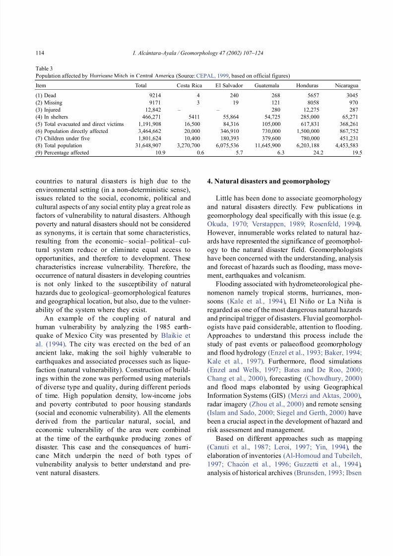
8102019 Articulo - Geomorphology Natural Hazards Vulnerability and Prevention of Natural Disasters in Developing Countrihellip
httpslidepdfcomreaderfullarticulo-geomorphology-natural-hazards-vulnerability-and-prevention-of 818
countries to natural disasters is high due to the
environmental setting (in a non-deterministic sense)
issues related to the social economic political and
cultural aspects of any social entity play a great role as
factors of vulnerability to natural disasters Although
poverty and natural disasters should not be considered
as synonyms it is certain that some characteristics
resulting from the economicndash socialndash politicalndash cul-
tural system reduce or eliminate equal access to
opportunities and therefore to development These
characteristics increase vulnerability Therefore the
occurrence of natural disasters in developing countries
is not only linked to the susceptibility of natural
hazards due to geologicalndashgeomorphological featuresand geographical location but also due to the vulner-
ability of the system where they exist
An example of the coupling of natural and
human vulnerability by analyzing the 1985 earth-
quake of Mexico City was presented by Blaikie et
al (1994) The city was erected on the bed of an
ancient lake making the soil highly vulnerable to
earthquakes and associated processes such as lique-
faction (natural vulnerability) Construction of build-
ings within the zone was performed using materials
of diverse type and quality during different periodsof time High population density low-income jobs
and poverty contributed to poor housing standards
(social and economic vulnerability) All the elements
derived from the particular natural social and
economic vulnerability of the area were combined
at the time of the earthquake producing zones of
disaster This case and the consequences of hurri-
cane Mitch underpin the need of both types of
vulnerability analysis to better understand and pre-
vent natural disasters
4 Natural disasters and geomorphology
Little has been done to associate geomorphology
and natural disasters directly Few publications in
geomorphology deal specifically with this issue (eg
Okuda 1970 Verstappen 1989 Rosenfeld 1994)
However innumerable works related to natural haz-
ards have represented the significance of geomorphol-
ogy to the natural disaster field Geomorphologists
have been concerned with the understanding analysis
and forecast of hazards such as flooding mass move-
ment earthquakes and volcanism
Flooding associated with hydrometeorological phe-
nomenon namely tropical storms hurricanes mon-soons (Kale et al 1994) El Nino or La Nina is
regarded as one of the most dangerous natural hazards
and principal trigger of disasters Fluvial geomorphol-
ogists have paid considerable attention to flooding
Approaches to understand this process include the
study of past events or palaeoflood geomorphology
and flood hydrology (Enzel et al 1993 Baker 1994
Kale et al 1997) Furthermore flood simulations
(Enzel and Wells 1997 Bates and De Roo 2000
Chang et al 2000) forecasting (Chowdhury 2000)
and flood maps elaborated by using GeographicalInformation Systems (GIS) (Merzi and Aktas 2000)
radar imagery (Zhou et al 2000) and remote sensing
(Islam and Sado 2000 Siegel and Gerth 2000) have
been a crucial aspect in the development of hazard and
risk assessment and management
Based on different approaches such as mapping
(Canuti et al 1987 Leroi 1997 Yin 1994) the
elaboration of inventories (Al-Homoud and Tubeileh
1997 Chacon et al 1996 Guzzetti et al 1994)
analysis of historical archives (Brunsden 1993 Ibsen
Table 3
Population affected by Hurricane Mitch in Central America (Source CEPAL 1999 based on official figures)
Item Total Costa Rica El Salvador Guatemala Honduras Nicaragua
(1) Dead 9214 4 240 268 5657 3045(2) Missing 9171 3 19 121 8058 970
(3) Injured 12842 ndash ndash 280 12275 287
(4) In shelters 466271 5411 55864 54725 285000 65271
(5) Total evacuated and direct victims 1191908 16500 84316 105000 617831 368261
(6) Population directly affected 3464662 20000 346910 730000 1500000 867752
(7) Children under five 1801624 10400 180393 379600 780000 451231
(8) Total population 31648907 3270700 6075536 11645900 6203188 4453583
(9) Percentage affected 109 06 57 63 242 195
I Alca ntara-Ayala Geomorphology 47 (2002) 107ndash124114
8102019 Articulo - Geomorphology Natural Hazards Vulnerability and Prevention of Natural Disasters in Developing Countrihellip
httpslidepdfcomreaderfullarticulo-geomorphology-natural-hazards-vulnerability-and-prevention-of 918
8102019 Articulo - Geomorphology Natural Hazards Vulnerability and Prevention of Natural Disasters in Developing Countrihellip
httpslidepdfcomreaderfullarticulo-geomorphology-natural-hazards-vulnerability-and-prevention-of 1018
panorama of the occurrence of such events and their
consequences
In the geomorphological dimensions of natural
disasters Rosenfeld (1994) examined the contribu-
tions of different geomorphological projects to inter-
disciplinary research including rainfall-induced land-
sliding cyclonic storms flooding etc Certainly the
use of remote sensing Global Positioning System
(GPS) and GIS has led to the incorporation of geo-
morphologists into the mapping analysis and model-
ing of such geophysical hydrological and geomor-
phological processes within the natural and human
hazards approach Rosenfeld illustrated the relation-
ship between the natural and human sides of the
Fig 6 Natural and geomorphology related disasters registered from 1990 to 1999 worldwide (Source EM-DAT database)
Fig 7 Estimated damage due to natural and geomorphology related disasters from 1990 to 1999 (Source EM-DAT database)
I Alca ntara-Ayala Geomorphology 47 (2002) 107ndash124116
8102019 Articulo - Geomorphology Natural Hazards Vulnerability and Prevention of Natural Disasters in Developing Countrihellip
httpslidepdfcomreaderfullarticulo-geomorphology-natural-hazards-vulnerability-and-prevention-of 1118
extent of natural hazards by using a pyramid-form
graph where the faces represent the duration and areal
extents of different hazards in terms of casualties and
hazard severity according to the different degree of
development of the countries and based on the level
response needed to cope with the disasters as a
function of economic development
By analyzing the EM-DAT database which
includes phenomena such as slides floods earth-
quakes volcanoes wind storms extreme tempera-
tures droughts wild fires and epidemics as natural
disasters it can be noticed that with exception of
extreme temperatures and epidemics all the other
ph en omen a are ge omor ph ol ogy rela te d Fig 5
presents the percentage of those disasters related to
geomorphology by type and region from 1900 to
1999 Between 1990 and 1999 2808 disasters were
recorded worldwide Eighty four percent of them wererelated to geomorphology (Fig 6) The total amount
of estimated damage (Fig 7) in relation to the global
natural disasters registered within the same period of
time and the number of people reported killed (Table
4) and affected (Fig 8) give a good indication of the
significance of geomorphology for the prevention of
natural disasters
The contribution of geomorphology to the field of
natural disasters is mainly through the elaboration of
hazard assessments In general such assessments
comprise stages like mapping modeling prediction
and management proposals using field observations
photogrammetry geographical information systems
and remote sensing the zonation and mapping of
different hazards is done Modeling approaches con-
sider not only the understanding of present but past
events leading to accurate predictions of the conse-
quences a geomorphic hazard may have on a deter-
mined landscape under a given conditions
Hazard assessment is a key part within the risk
analysis process Certainly geomorphologists have
contributed enormously on this matter Nevertheless
Table 4
Total number of people reported killed by continent and by type of
phenomenon from 1990 to 1999 (Source EM-DAT database)
Africa Americas Asia Europe Oceania Total
Slides 225 2010 5500 644 279 8658
Droughts 12 0 2680 0 98 2790
Earthquakes 816 3519 91878 2395 70 98678
Floods 9487 35598 55916 2839 30 103870
Wind Storms 1612 13264 185739 913 262 201790
Volcanoes 0 77 994 0 9 1080
Total 12152 54468 342707 6791 748 416866
Fig 8 People affected due to natural and geomorphology related disasters from 1990 to 1999 (Source EM-DAT database)
I Alca ntara-Ayala Geomorphology 47 (2002) 107ndash124 117
8102019 Articulo - Geomorphology Natural Hazards Vulnerability and Prevention of Natural Disasters in Developing Countrihellip
httpslidepdfcomreaderfullarticulo-geomorphology-natural-hazards-vulnerability-and-prevention-of 1218
a greater progress would be achieved if vulnerability
analysis were also taken into account
5 Geomorphology vulnerability and disasters
By examining the different definitions of natural
hazards and natural disasters it is clear that the
conceptualization has changed from a perspective of
a merely physical or natural event towards the inte-
gration of the human system Initially the uncontrol-
lable character of natural hazards directed efforts
towards coping with their impacts and also towards
the prediction of these events Technological advances
and the development of prediction models for vol-
canic activity hurricanes tsunamis flooding land-
sliding etc were developed seeking a better under-
standing of the phenomena and to some extent to offer
possibilities to cope with the impact of natural haz-
ards but mainly in lsquodeveloped countriesrsquo
Later in the 1960s the idea of the devastation by
natural disasters as a result of the social and economic
characteristics of the regions where natural hazards
took place was introduced (White 1961 1964 Kates
1962 Burton et al 1968 Hewitt and Burton 1971)
However it was not until the 1970s that the role of
economic and social conditions as factors of vulner-ability to natural disasters was acknowledged
The interest of understanding not only the natural
events per se but the characteristics of risk in the
areas prone to these phenomena has moved the
attention of many social scientists towards the study
of risk and vulnerability (eg Albala-Bertrand 1993
Blaikie et al 1994 Cannon 1993 Varley 1991
Winchester 1992) Previous investigations have
shown the need for defining and measuring hazard
events in a non-scientific (physical) view This
includes the description and analyses of different perceptions of hazard (Burton et al 1968) based on
the concept of differential perception of risk a very
important factor in the development of risk manage-
ment approaches
At the present time not only social scientists but
geoscientists are considering the socio-economic char-
acter of some regions prone to natural hazards as one
of the main factors of vulnerability to natural disasters
For instance Cardona (1997) considered the social
economic and institutional aspects within the manage-
ment of the crisis of Galer as volcano in Colombia
Dibben and Chester (1999) proposed a framework to
analyze human vulnerability in the case of Furnas
volcano in the Azores They recognized that peoplersquosvulnerability to volcanic hazards implies an interaction
of different elements related to the social context and
the corresponding physiological and psychological
characteristics In his overview of volcanic geomor-
phology Thouret (1999) pointed out that in order to
cope with the consequences of natural hazards and their
interaction with people living around the volcanoes
geomorphology is an essential part to undertake risk
assessment based on geomorphic hazard and risk
zonation
51 A closer look to vulnerability
The study of vulnerability related to natural disas-
ters has been the focus of different investigations and
hence of several definitions Westgate and OrsquoKeefe
(1976) defined vulnerability as the degree to which a
community is at risk from the occurrence of extreme
physical or natural phenomena where risk refers to the
probability of occurrence and the degree to which
socio-economic and socio-political factors affect the
communityrsquos capacity to absorb and recover from
extreme phenomena For Varley (1991) vulnerabilityis a function of the degree of social and self-protection
available to potential victims It is clearly related to the
ability of households or communities to cope with and
recover from outside events and particularly to shocks
and sudden changes (Maskey 1993) It also concerns
the predisposition of a society to experience substan-
tial damage as a result of natural hazards (Clarke and
Munasinghe 1995) These definitions imply that vul-
nerability is the result of the socio-economic and
political systems of the entity in danger However it
is the definition of Cannon (1993) which considersdifferent factors affecting or producing the vulnerabil-
ity of individuals or groups that is most germane
According to him vulnerability lsquolsquois a characteristic of
individuals and groups of people who inhabit a given
natural social and economic space within which they
are differentiated according to their varying position in
society into more or less vulnerable individuals and
groups It is a complex characteristics produced by a
combination of factors derived especially (but not
entirely) from class gender or ethnicityrsquorsquo Cannon
I Alca ntara-Ayala Geomorphology 47 (2002) 107ndash124118
8102019 Articulo - Geomorphology Natural Hazards Vulnerability and Prevention of Natural Disasters in Developing Countrihellip
httpslidepdfcomreaderfullarticulo-geomorphology-natural-hazards-vulnerability-and-prevention-of 1318
divided vulnerability into three parts (1) Livelihood
resilience the degree of resilience of the particular
livelihood system of an individual or group and their
capacity for resisting the impact of hazard (2) Healthincluding both the robustness of individuals and the
operation of various social measures (3) Preparedness
determined by the protection available for a given
hazard something that depends on people acting on
their own behalf and social factors
These three aspects cover a great proportion of the
different kinds of vulnerabilities Nevertheless each
aspect has different components and the combinations
of them can be so numerous that it is necessary to
specify the particular types of vulnerability of each
threatened entity The latter will provide an adequate
understanding of the total vulnerability to natural
disasters so that prevention can be effectively accom-
plished This insight strengthens the contribution of
Aysan (1993) who recognizes different kinds of
vulnerability as follows
Lack of access to resources (materialseconomic
vulnerability) Disintegration of social patterns (social vulnerabil-
ity) Lack of strong national and local institutional
structures (organizational vulnerability) Lack of access to information and knowledge
(educational vulnerability) Lack of public awareness (attitudinal and motiva-
tional vulnerability) Limited access to political power and representa-
tion (political vulnerability) Certain beliefs and customs (cultural vulner-
ability) Weak buildings of weak individuals (physical
vulnerability)
There are indeed many other kinds of vulnerability
However all of them can be inserted within four main
types of vulnerability social economic political and
cultural This classification indicates that each social
entity has different types of vulnerability and it is not
only the result of the human actions decisions and
choices it is the result of the interaction of the natural
economic social cultural and political contexts where
people live Vulnerability cannot be treated as a
homogeneous and general term its dynamism is given
by each society and it is both a universal and
particular concept There is certainly a differential
character of vulnerability Vulnerability is given by
t he coupling between the natural and human systems(Fig 9) In this sense vulnerability can be divided
into natural vulnerability and human vulnerability
Natural vulnerability depends on the threatening nat-
ural hazard (very much related to geographical loca-
tion) thus there is volcanic vulnerability flooding
vulnerability landsliding vulnerability tsunamis vul-
nerability hurricane vulnerability and so on On con-
trast human vulnerability is based on the social
economical political and cultural systems
Hence vulnerability can be defined as the propen-
sity of an endangered element due to any kind of
natural hazard to suffer different degrees of loss or
amount of damage depending on its particular social
economic cultural and political weaknesses Total
vulnerability is a function of the individual types of
vulnerability present in a given area Such vulnerabil-
ity determines the magnitude of the disaster the level
of resilience and the recovery process
52 A step forward into the prevention of natural
disasters applied geomorphology
The reduction of natural vulnerability could beobtained from an equal access to scientific informa-
tional resources and methodologies for the understand-
ing and prediction of natural hazards (eg state-of-art
predicting models) and to international training pro-
grams Natural hazards cannot be prevented but the
understanding of the process and scientific method-
ologies to predict patterns of behavior of such pro-
cesses can be powerful tools to help reduce natural
vulnerability
Geomorphological research can provide theoretical
and applied approaches to the prevention of naturaldisasters in terms of origin and dynamism of the
physical processes Furthermore geomorphologists
could also offer important contributions based on the
understanding of the interaction between natural haz-
ards (natural vulnerability) and the societies (human
vulnerability) Consequently they should be involved
to a greater extent in such tasks as is the case of the
contributions of D Alexander M Panizza and HT
Verstappenmdashto mention the most familiar examplesmdash
who not only have shed light on understanding geo-
I Alca ntara-Ayala Geomorphology 47 (2002) 107ndash124 119
8102019 Articulo - Geomorphology Natural Hazards Vulnerability and Prevention of Natural Disasters in Developing Countrihellip
httpslidepdfcomreaderfullarticulo-geomorphology-natural-hazards-vulnerability-and-prevention-of 1418
morphological processes but also on the strong link
between the processes and society
Geomorphology can be considered a strategic
discipline in the reduction of both human and natural
vulnerabilities By contributing to the understanding
of endogenetic and exogenetic processes method-
ologies to predict patterns of occurrence of hazardous
events can be developed and applied Geomorpholo-
gists assist in the reduction of natural vulnerability inthree different ways first by enriching the theoretical
knowledge of geomorphology which is the base of
the application of our discipline second by develop-
ing prediction models for different processes such as
landsliding flooding volcanism among others and
finally through diversified approaches of applied
geomorphology for the prevention of natural disas-
ters Indeed geomorphology is a powerful field that
must play a role in the interdisciplinary efforts to
develop adequate strategies for prevention and miti-
gation of natural disasters Nonetheless contributions
of geomorphology would be even more significant if
research applications were directed towards the
understanding and coupling of human and natural
vulnerabilities Reduction of natural disasters is a
complex task by nature however it is now clear
that a combination not only of social and scientific
knowledge but also of attitudes towards the elabo-
ration of adequate strategies based on vulnerabilityanalysis of the particular social entities is urgently
required
6 Conclusions
Natural hazards are threatening events capable of
producing damage to the physical and social space in
which they take place not only at the moment of their
occurrence but in the long-term due to their associ-
Fig 9 The ingredients of natural disasters
I Alca ntara-Ayala Geomorphology 47 (2002) 107ndash124120
8102019 Articulo - Geomorphology Natural Hazards Vulnerability and Prevention of Natural Disasters in Developing Countrihellip
httpslidepdfcomreaderfullarticulo-geomorphology-natural-hazards-vulnerability-and-prevention-of 1518
ated consequences When these consequences have an
impact on society andor infrastructure they become
natural disasters These can be considered as sudden
but expected (we all know that they occur) naturalevents which impact the human and natural systems
The degree of their impact in space and time is a
function of the exposure to and the magnitude of the
natural phenomena (natural vulnerability) and the
human vulnerability of the threatened entity
Natural disasters occur all over the world how-
ever their impact in developing countries is greater
due to the geographical location in zones highly
susceptible to natural hazards (natural vulnerability)
and also due to the different types of economic social
political and cultural vulnerabilities that exist These
vulnerabilities are indeed the result of their historical
development and their social political economic and
cultural contexts The rich get richer the poor poorer
and the access to opportunities within the social entity
are unequal and indirectly proportional to the occur-
rence of natural disasters (the less opportunities the
more vulnerability the more affected by natural dis-
asters)
The International Decade for Natural Disaster
Reduction (IDNDR) has achieved several goals such
as the organization of international groups to provide
advice on the prevention of natural disasters onregional and national bases Events such as Hurricane
Mitch in Central America (October 1998) the earth-
quake in Turkey (August 1999) and their devastating
consequences demonstrated that natural disasters
occur in places where the geographical coordinates
of natural and human vulnerabilities converge An
effort must be made to promote the elaboration of
vulnerability analysis within a risk assessment and
management framework where not only geomor-
phology but also geomorphologists play a key role
for the prevention of natural disasters The latter needs indeed to be more rapidly implemented in
developing countries
Acknowledgements
Natural disasters registered data were kindly
provided by the ODFACRED International Disaster
Database Center for Research into the Epidemiology of
Disasters (CRED) Catholic University of Louvain
Belgium (httpwwwmduclacbecred) and the Of-
fice of US Foreign Disaster Assistance (httpwww
usaidgovhum _ responseofda ) Thanks are also due to
BE Montz CL Rosenfeld and PLK Knuepfer for critical reviewing of this paper
References
Albala-Bertrand JM 1993 Political Economy of Large Natural
Disasters With Special Reference to Developing Countries Ox-
ford Univ Press London 259 pp
Alexander D 1993 Natural Disasters UCL Press and Chapman amp
Hall New York 632 pp
Al-Homoud AS Tubeileh T 1997 An inventory for evaluating
hazard and risk assessment of cut slopes in weak rocks along
highways Bull Int Assoc Eng Geol 55 39ndash51Anderson JL Decker RW 1992 Volcano risk mitigation
through training In McCall GJH Laming DJC Scott
SC (Eds) Geohazards Natural and Man-Made Chapman amp
Hall London pp 7 ndash 12
Anderson MG Collison AJC Hartshorne J Lloyd DM
Park A 1996 Developments in slope hydrology-stability mod-
eling for tropical slopes In Anderson MG Brooks SM
(Eds) Advances in Hillslope Processes vol 2 Wiley Chiches-
ter pp 799ndash821
Aysan YF 1993 Vulnerability assessment In Merriman PA
Browitt CWA (Eds) Natural Disasters Protecting Vulnerable
Communities Thomas Telford London pp 1 ndash 14
Baker VR 1994 Geomorphological understanding of floods Geo-
morphology 10 139ndash156
Barkun N 1974 Disaster and the Millenium Yale Univ Press
New Haven
Bates PD De Roo APJ 2000 A simple raster-based model for
flood inundation simulation J Hydrol 236 54ndash77
Blaikie P Cannon T Davis I Wisner B 1994 At Risk Natural
Hazards Peoplersquos Vulnerability and Disasters Routledge Lon-
don 284 pp
Brooks SM Collison AJC 1996 The significance of soil pro-
file differentiation to hydrological response and slope instability
a modeling approach In Anderson MG Brooks SM (Eds)
Advances in Hillslope Processes vol 2 Wiley Chichester pp
471ndash486
Brunsden D 1993 Mass movement the research frontier and bey ond a geomor phological approa ch Geom orp hology 7
85ndash128
Brunsden D 1999 Some geomorphological considerations for the
future development of landslide models Geomorphology 30
13ndash24
Burton I Kates RW 1964 The perception of natural hazards in
resource management Nat Resour J 3 412ndash441
Burton I Kates RW White GF 1968 The Human Ecology of
Extreme Geophysical Events Department of Geography Natu-
ral Hazards Research Working Paper No 1 University of Tor-
onto
Cannon T 1993 A hazard need not a disaster make vulnerability
I Alca ntara-Ayala Geomorphology 47 (2002) 107ndash124 121
8102019 Articulo - Geomorphology Natural Hazards Vulnerability and Prevention of Natural Disasters in Developing Countrihellip
httpslidepdfcomreaderfullarticulo-geomorphology-natural-hazards-vulnerability-and-prevention-of 1618
and the causes of lsquonaturalrsquo disasters In Merriman PA Bro-
witt CWA (Eds) Natural Disasters Protecting Vulnerable
Communities Thomas Telford London pp 92ndash 105
Canuti P Focardi P Garzonia CA Rodolfi G Vannocci P
1987 Slope stability mapping in Tuscany Italy In Gardiner V(Ed) International Geomorphology 1986 Part I Wiley London
pp 231 ndash 240
Cardona OD 1997 Management of the volcanic crises of Galeras
volcano social economic and institutional aspects J Volcanol
Geother Res 77 313ndash324
Carrara A Cardinali M Detti R Guzzetti F Pasqui V Reich-
enbach P 1990 Geographical information systems and multi-
variate models in landslide hazard evaluation In Cancelli A
(Ed) Alps 90 Int Conf and Field Workshop on Landslides
Milano pp 17ndash 28
CEPAL 1999 Central America Assessment of the Damage Caused
by Hurricane Mitch 1998 Implications for Economic and So-
cial Development and for the Environment 41 pp At http
wwwcepalorgmx
Chacon J Irigaray C El Hamdouni R Fernandez T 1996
From the inventory to the risk analisis improvements to a large
scale GIS method In Chacon J Irigaray C Fernandez T
(Eds) Landslides Balkema Rotterdam pp 335ndash342
Chandler JH Brunsden D 1995 Steady state behaviour of the
Black Ven mudslide the application of archival analytical pho-
togrammetry to studies of landform change Earth Surf Pro-
cesses Landf 20 255ndash275
Chandler JH Cooper MAR 1989 The extraction of positional
data from historical photographs and their application in geo-
morphology Photogramm Rec 13 (73) 69 ndash 78
Chandler JH Moore R 1989 Analytical photogrammetry a
method for monitoring slope instability Q J Eng Geol 2297ndash110
Chang TJ Hsu MH Teng WH Huang CJ 2000 A GIS-
assisted distributed watershed model for simulating flooding and
inundation J Am Wat Resour Assoc 36 (5) 975 ndash 988
Chowdhury MR 2000 An assessment of flood forecasting in
Bangladesh the experience of the 1998 flood Nat Hazards
22 (2) 139ndash163
Clarke C Munasinghe M 1995 Economic aspects of disasters
and sustainable development an introduction In Munasinghe
M Clarke C (Eds) Disaster Prevention for Sustainable De-
velopment Economy and Policy Issues IDNDR and the World
Bank Washington pp 1ndash10
Collison AJC Anderson MG 1996 Using a combined slope
hydrology-slope stability model to identify suitable conditionsfor landslide prevention by vegetation in the humid tropics
Earth Surf Processes Landf 21 (8) 737ndash747
Collison AJC Anderson MG Lloyd DM 1995 The impact
of vegetation on slope stability in a humid tropical environment
a modeling approach Inst Civil Eng Water Marit Energy 112
168ndash175
Corominas J Moya J 1996 Historical landslides in the eastern
Pyrenees and their relation to rainy events In Chacon J Iri-
garay C Fernandez T (Eds) Landslides Balkema Rotter-
dam pp 125ndash132
Dibben C Chester DK 1999 Human vulnerability in volcanic
environments the case of Furnas Sao Miguel Azores J Vol-
canol Geother Res 92 (1ndash2) 133ndash150
Dikau R Jaeger S 1993 The role of geomorphology in regional
landslide hazard assessment using GIS technologies In Reich-
enbach P Guzzetti F Carrara A (Eds) Workshop on Geo-graphic Information Systems in Assessing Natural Hazards
Univ Foreigners Perugia Italy pp 54 ndash 55
Dikau R Cavallin A Jaeger S 1992 Database and GIS for
landslide research in Europe In Casale R Fantechi R Flag-
eollet JC (Eds) Temporal Occurrence and Forecasting of
Landslides in the European Community Final Report vol 1
pp 97 ndash 116
Domınguez-Cuesta MJ Jimınez-Sanchez M Rodrıguez-Garcıa
A 1999 Press archives as temporal records of landslides in the
north of Spain relationships between rainfall and instability
slope events Geomorphology 30 125ndash132
Dowdeswell JA Lamb HF Lewin J 1988 Failure and flow on
a 35 degrees slope causes and three-dimensional observations
Earth Surf Processes Landf 13 737ndash746
Elsinga RJ Verstappen HT 1988 SPOT for earthquake hazard
zoning in southern Italy SPOT 1 Image utilization assessment
results Techniques Spatiales 1 Centre National drsquoEtudes Spa-
tiales Toulouse France pp 199ndash207
EM-DAT The OFDACRED International Disaster Database At
httpwwwcredbeemdat Universite Catholique de Louvain
Brussels Belgium
Enzel Y Wells SG 1997 Extracting Holocene paleohydrology
and paleoclimatology information from modern extreme flood
events an example from Southern California Geomorphology
19 203ndash226
Enzel Y Ely LL House PK Baker VR Webb RH 1993
Paleoflood evidence for a natural upper bound to flood magni-tudes in the Colorado River Water Resour Res 29 (7) 2287ndash
2297
Erdik M Biro YA Onur T Sesetyan K Birgoren G 1999
Assessment of earthquake hazard in Turkey and neighboring
regions Ann Geofis 42 1125ndash1138
Fritz CE 1961 Disasters In Merton RK Nisbet RA (Eds)
Contemporary Social Problems Harcourt New York pp 651ndash
694
Galadini F Galli P 2000 Active tectonics in the central Apen-
nines (Italy)mdashinput data for seismic hazard assessment Nat
Hazards 22 (3) 225ndash270
Gares PA Sherman DJ Nordstrom KF 1994 Geomorphology
and natural hazards Geomorphology 10 1ndash18
Gili JA Corominas J Rius J 2000 Using global positioningsystem techniques in landslide monitoring Eng Geol 55 (3)
167ndash192
Gomez-Fernandez F 2000 Contribution of geographical informa-
tion systems to the management of volcanic crises Nat Hazards
21 (2ndash 3) 347ndash 360
Guzzetti F Cardinali M Reichenbach P 1994 The AVI project
a bibliographical and archive inventory of landslides and floods
in Italy Environ Manage 18 (4) 623ndash633
Hansen A 1984 Landslide hazard analysis In Brunsden D
Prior DB (Eds) Slope Instability Wiley Chichester pp
523ndash602
I Alcantara-Ayala Geomorphology 47 (2002) 107ndash124122
8102019 Articulo - Geomorphology Natural Hazards Vulnerability and Prevention of Natural Disasters in Developing Countrihellip
httpslidepdfcomreaderfullarticulo-geomorphology-natural-hazards-vulnerability-and-prevention-of 1718
Hewitt K Burton I 1971 The Hazardousness of a Place A
Regional Ecology of Damaging Events Research Paper No 6
Department of Geography University of Toronto
Hutchinson JN 1992 Landslide Hazard Assessment Proc 6th
Int Symp on Landslides Christchurch New Zealand vol 3 pp 3 ndash 35
Ibsen ML Brunsden D 1996 The nature use and problems of
historical archives for the temporal occurrence of landslides
with specific reference to the south coast of Britain Ventnor
Isle of Wight Geomorphology 15 241ndash258
IDNDR 1992 Glossary Internationally Agreed Glossary of Basic
Terms Related to Disaster Management DHA-Geneva 83 pp
Islam MDM Sado K 2000 Development of flood hazard maps
of Bangladesh using NOAA-AVHRR images with GIS Hydrol
Sci J 45 337ndash355
Jenkins A Ashworth PJ Ferguson RI Grieve IC Rowling
P Stott TA 1988 Slope failures in the Ochil Hills Scotland
November 1984 Earth Surf Processes Landf 13 69 ndash 76
Kale VS Ely LL Enzel Y Baker VR 1994 Geomorphic and
hydrologic aspects of monsoon floods on the Narmada and Tapi
Rivers in central India Geomorphology 10 157ndash168
Kale VS Hire P Baker VR 1997 Flood hydrology and geo-
morphology of monsoon-dominated rivers the Indian Peninsu-
la Water Int 22 259ndash265
Kates RW 1962 Hazard and Choice Perception in Flood Plain
Management Research Paper No 78 Department of Geogra-
phy University of Chicago
Leroi E 1997 Landslide risk mapping problems limitations and
developments In Cruden DM Fell R (Eds) Landslide Risk
Assessment Balkema Rotterdam pp 239 ndash 250
Mantovani F Soeters R Van Westen CJ 1996 Remote sensing
techniques for landslide studies and hazard zonation in EuropeGeomorphology 15 213ndash225
Maskey A 1993 Vulnerability accumulation in peripheral regions
in Latin America the challenge for disaster prevention and
management In Merriman PA Browitt CWA (Eds) Nat-
ural Disasters Protecting Vulnerable Communities Thomas
Telford London pp 461ndash472
Merzi N Aktas MT 2000 Geographic information systems
(GIS) for the determination of inundation maps of Lake Mogan
Turkey Water Int 25 (3) 474ndash480
Montgomery DR Dietrich WE 1994 A physically based model
for the topographic control on shallow landsliding Water Re-
sour Res 30 (4) 1153ndash1171
Okuda S 1970 On the relation between physical geomorphology
and the science of natural disasters Bull Disaster Prev ResInst 19 (25) Part 5 Kyoto Japan
Ordaz M Reyes C 1999 Earthquake hazard in Mexico City
observations versus computations Bull Seismol Soc Am 89
(5) 1379ndash 1383
Panizza M 1981 Geomorphology and earthquake hazard in envi-
ronmental planning In Palmentola G Acquafredda P (Eds)
Proceedings of the International Conference on Seismic Zones
in the Mediterranean Area Basilicata Italy pp 203ndash207
Panizza M 1991 Geomorphology and seismic risk Earth-Sci
Rev 31 (1) 11ndash20
Pareschi MT Cavarra L Favalli M Giannini F Meriggi A
2000 GIS and volcanic risk management Nat Hazards 21 (2ndash
3) 361ndash379
Petley DN 1998 Geomorphological mapping for hazard assess-
ment in a neotectonic terrain Geogr J 164 (7) 183ndash201
Proske H 1996 GIS supported analysis of effects of joint systemson shallow landslides in a tectonically complex crystalline
catchment area In Chacon J Irigaray C Fernandez T
(Eds) Landslides Balkema Rotterdam pp 173ndash180
Rosenfeld CL 1994 The geomorphological dimensions of natural
disasters Geomorphology 10 27ndash36
Scheidegger AE 1994 Hazards singularities in geomorphic sys-
tems Geomorphology 10 19ndash25
Siegel H Gerth M 2000 Satellite-based studies of the 1997 Oder
flood event in the southern Baltic Sea Remote Sens Environ
73 (2) 207ndash217
Singhroy V Mattar KE Gray AL 1998 Landslide character-
isation in Canada using interferometric SAR and combined SAR
and TM images Adv Space Res 21 (3) 465ndash476
Slaymaker O 1996 Introduction In Slaymaker O (Ed) Geo-
morphic Hazards Wiley Chichester pp 1ndash7
Sousa J Voight B 1992 Computational flow modeling for long-
runout landslide hazard assessment with an example from Cla-
piere landslide France Bull Assoc Eng Geol 29 (2) 131 ndash
150
Summerfield MA 1991 Global Geomorphology An Introduction
to the Study of Landforms Wiley New York 537 pp
Terlien MTJ 1996 The prediction of rainfall-triggered soil slips
in Manizales (Colombia) In Chacon J Irigaray C Fernan-
dez T (Eds) Landslides Balkema Rotterdam pp 197 ndash 205
Thornes JB Alcantara-Ayala I 1998 Modelling mass failure in a
Mediterranean mountain environment climatic geological
topographical and erosional controls Geomorphology 24 87ndash 100
Thouret JC 1999 Urban hazards and risks consequences of
earthquakes and volcanic eruptions an introduction GeoJournal
49 (2) 131ndash135
Tobin GA Montz BE 1997 Natural Hazards Explanation and
Integration The Guilford Press New York 388 pp
UNDRO 1982 Natural Disasters and Vulnerability Analysis Of-
fice of the United Nations Disaster Relief Coordinator Geneva
Switzerland
Van Asch TWJ Buma JT 1997 Modelling groundwater fluc-
tuations and the frequency of movement of a landslide in the
Terres Noires region of Barcelonnette (France) Earth Surf Pro-
cesses Landf 22 131ndash141
Varley A 1991 Disasters vulnerability and response Disasters 15(3) 285ndash287
Verstappen HT 1988 Geomorphological surveys and natural haz-
ard zoning with special reference to volcanic hazards in central
Java Z Geomorphol Supplbd 68 81ndash101
Verstappen HT 1989 Geomorphology natural disasters and glob-
al change Symposium on Aerospace Survey and Natural Dis-
asters ITC J (3ndash4) 159ndash164
Verstappen HT 1992 Volcanic hazards in Colombia and Indone-
sia lahars and related phenomena In McCall GJH Laming
DDC Scott SC (Eds) Geohazards Natural and Man-Made
Chapman amp Hall London pp 33ndash42
I Alcantara-Ayala Geomorphology 47 (2002) 107ndash124 123
8102019 Articulo - Geomorphology Natural Hazards Vulnerability and Prevention of Natural Disasters in Developing Countrihellip
httpslidepdfcomreaderfullarticulo-geomorphology-natural-hazards-vulnerability-and-prevention-of 1818
Westgate KN OrsquoKeefe P 1976 Some Definitions of Disaster
Disaster Research Unit Occasional Paper No 4 Department of
Geography University of Bradford
White GF (Ed) 1961 Papers on Flood Problems Research Pa-
pers No 70 Department of Geography University of ChicagoWhite GF 1964 Choice of Adjustments to Floods Research Pa-
per No 93 Department of Geography University of Chicago
White GF 1973 Natural hazards research In Chorley RJ (Ed)
Directions in Geography Methuen London pp 193 ndash 216
Winchester P 1992 Power Choice and Vulnerability A Case
Study in Disaster Management in South India James amp James
London 225 pp
Wolman MG Miller JP 1960 Magnitude and frequency of
forces in geomorphic processes J Geol 68 (1) 54ndash74
Yin KL 1994 A computer-assisted mapping of landslide hazardevaluation 7th International IAEG Congress Balkema Rotter-
dam pp 4495ndash 4499
Zhou CH Luo JC Yang CJ Li BL Wang SL 2000 Flood
monitoring using multi-temporal AVHRR and RADARSAT im-
agery Photogramm Eng Remote Sensing 66 (5) 633ndash638
I Alca ntara-Ayala Geomorphology 47 (2002) 107ndash124124
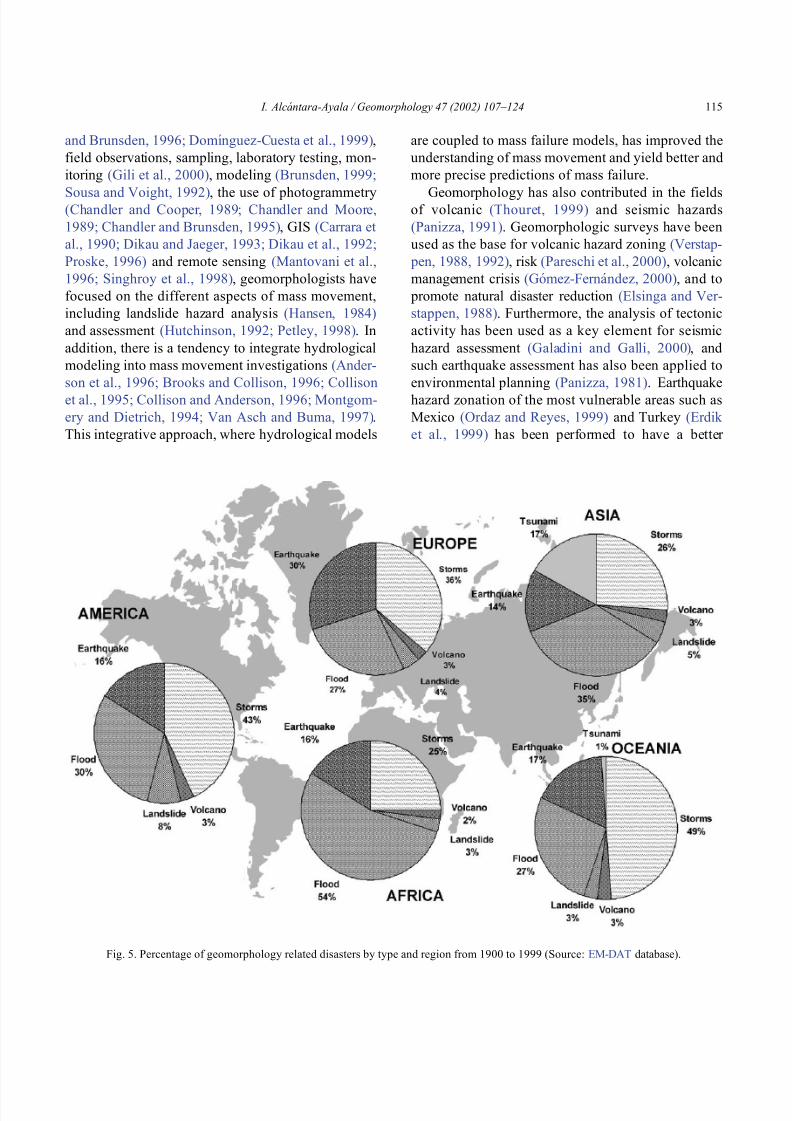
8102019 Articulo - Geomorphology Natural Hazards Vulnerability and Prevention of Natural Disasters in Developing Countrihellip
httpslidepdfcomreaderfullarticulo-geomorphology-natural-hazards-vulnerability-and-prevention-of 918
8102019 Articulo - Geomorphology Natural Hazards Vulnerability and Prevention of Natural Disasters in Developing Countrihellip
httpslidepdfcomreaderfullarticulo-geomorphology-natural-hazards-vulnerability-and-prevention-of 1018
panorama of the occurrence of such events and their
consequences
In the geomorphological dimensions of natural
disasters Rosenfeld (1994) examined the contribu-
tions of different geomorphological projects to inter-
disciplinary research including rainfall-induced land-
sliding cyclonic storms flooding etc Certainly the
use of remote sensing Global Positioning System
(GPS) and GIS has led to the incorporation of geo-
morphologists into the mapping analysis and model-
ing of such geophysical hydrological and geomor-
phological processes within the natural and human
hazards approach Rosenfeld illustrated the relation-
ship between the natural and human sides of the
Fig 6 Natural and geomorphology related disasters registered from 1990 to 1999 worldwide (Source EM-DAT database)
Fig 7 Estimated damage due to natural and geomorphology related disasters from 1990 to 1999 (Source EM-DAT database)
I Alca ntara-Ayala Geomorphology 47 (2002) 107ndash124116
8102019 Articulo - Geomorphology Natural Hazards Vulnerability and Prevention of Natural Disasters in Developing Countrihellip
httpslidepdfcomreaderfullarticulo-geomorphology-natural-hazards-vulnerability-and-prevention-of 1118
extent of natural hazards by using a pyramid-form
graph where the faces represent the duration and areal
extents of different hazards in terms of casualties and
hazard severity according to the different degree of
development of the countries and based on the level
response needed to cope with the disasters as a
function of economic development
By analyzing the EM-DAT database which
includes phenomena such as slides floods earth-
quakes volcanoes wind storms extreme tempera-
tures droughts wild fires and epidemics as natural
disasters it can be noticed that with exception of
extreme temperatures and epidemics all the other
ph en omen a are ge omor ph ol ogy rela te d Fig 5
presents the percentage of those disasters related to
geomorphology by type and region from 1900 to
1999 Between 1990 and 1999 2808 disasters were
recorded worldwide Eighty four percent of them wererelated to geomorphology (Fig 6) The total amount
of estimated damage (Fig 7) in relation to the global
natural disasters registered within the same period of
time and the number of people reported killed (Table
4) and affected (Fig 8) give a good indication of the
significance of geomorphology for the prevention of
natural disasters
The contribution of geomorphology to the field of
natural disasters is mainly through the elaboration of
hazard assessments In general such assessments
comprise stages like mapping modeling prediction
and management proposals using field observations
photogrammetry geographical information systems
and remote sensing the zonation and mapping of
different hazards is done Modeling approaches con-
sider not only the understanding of present but past
events leading to accurate predictions of the conse-
quences a geomorphic hazard may have on a deter-
mined landscape under a given conditions
Hazard assessment is a key part within the risk
analysis process Certainly geomorphologists have
contributed enormously on this matter Nevertheless
Table 4
Total number of people reported killed by continent and by type of
phenomenon from 1990 to 1999 (Source EM-DAT database)
Africa Americas Asia Europe Oceania Total
Slides 225 2010 5500 644 279 8658
Droughts 12 0 2680 0 98 2790
Earthquakes 816 3519 91878 2395 70 98678
Floods 9487 35598 55916 2839 30 103870
Wind Storms 1612 13264 185739 913 262 201790
Volcanoes 0 77 994 0 9 1080
Total 12152 54468 342707 6791 748 416866
Fig 8 People affected due to natural and geomorphology related disasters from 1990 to 1999 (Source EM-DAT database)
I Alca ntara-Ayala Geomorphology 47 (2002) 107ndash124 117
8102019 Articulo - Geomorphology Natural Hazards Vulnerability and Prevention of Natural Disasters in Developing Countrihellip
httpslidepdfcomreaderfullarticulo-geomorphology-natural-hazards-vulnerability-and-prevention-of 1218
a greater progress would be achieved if vulnerability
analysis were also taken into account
5 Geomorphology vulnerability and disasters
By examining the different definitions of natural
hazards and natural disasters it is clear that the
conceptualization has changed from a perspective of
a merely physical or natural event towards the inte-
gration of the human system Initially the uncontrol-
lable character of natural hazards directed efforts
towards coping with their impacts and also towards
the prediction of these events Technological advances
and the development of prediction models for vol-
canic activity hurricanes tsunamis flooding land-
sliding etc were developed seeking a better under-
standing of the phenomena and to some extent to offer
possibilities to cope with the impact of natural haz-
ards but mainly in lsquodeveloped countriesrsquo
Later in the 1960s the idea of the devastation by
natural disasters as a result of the social and economic
characteristics of the regions where natural hazards
took place was introduced (White 1961 1964 Kates
1962 Burton et al 1968 Hewitt and Burton 1971)
However it was not until the 1970s that the role of
economic and social conditions as factors of vulner-ability to natural disasters was acknowledged
The interest of understanding not only the natural
events per se but the characteristics of risk in the
areas prone to these phenomena has moved the
attention of many social scientists towards the study
of risk and vulnerability (eg Albala-Bertrand 1993
Blaikie et al 1994 Cannon 1993 Varley 1991
Winchester 1992) Previous investigations have
shown the need for defining and measuring hazard
events in a non-scientific (physical) view This
includes the description and analyses of different perceptions of hazard (Burton et al 1968) based on
the concept of differential perception of risk a very
important factor in the development of risk manage-
ment approaches
At the present time not only social scientists but
geoscientists are considering the socio-economic char-
acter of some regions prone to natural hazards as one
of the main factors of vulnerability to natural disasters
For instance Cardona (1997) considered the social
economic and institutional aspects within the manage-
ment of the crisis of Galer as volcano in Colombia
Dibben and Chester (1999) proposed a framework to
analyze human vulnerability in the case of Furnas
volcano in the Azores They recognized that peoplersquosvulnerability to volcanic hazards implies an interaction
of different elements related to the social context and
the corresponding physiological and psychological
characteristics In his overview of volcanic geomor-
phology Thouret (1999) pointed out that in order to
cope with the consequences of natural hazards and their
interaction with people living around the volcanoes
geomorphology is an essential part to undertake risk
assessment based on geomorphic hazard and risk
zonation
51 A closer look to vulnerability
The study of vulnerability related to natural disas-
ters has been the focus of different investigations and
hence of several definitions Westgate and OrsquoKeefe
(1976) defined vulnerability as the degree to which a
community is at risk from the occurrence of extreme
physical or natural phenomena where risk refers to the
probability of occurrence and the degree to which
socio-economic and socio-political factors affect the
communityrsquos capacity to absorb and recover from
extreme phenomena For Varley (1991) vulnerabilityis a function of the degree of social and self-protection
available to potential victims It is clearly related to the
ability of households or communities to cope with and
recover from outside events and particularly to shocks
and sudden changes (Maskey 1993) It also concerns
the predisposition of a society to experience substan-
tial damage as a result of natural hazards (Clarke and
Munasinghe 1995) These definitions imply that vul-
nerability is the result of the socio-economic and
political systems of the entity in danger However it
is the definition of Cannon (1993) which considersdifferent factors affecting or producing the vulnerabil-
ity of individuals or groups that is most germane
According to him vulnerability lsquolsquois a characteristic of
individuals and groups of people who inhabit a given
natural social and economic space within which they
are differentiated according to their varying position in
society into more or less vulnerable individuals and
groups It is a complex characteristics produced by a
combination of factors derived especially (but not
entirely) from class gender or ethnicityrsquorsquo Cannon
I Alca ntara-Ayala Geomorphology 47 (2002) 107ndash124118
8102019 Articulo - Geomorphology Natural Hazards Vulnerability and Prevention of Natural Disasters in Developing Countrihellip
httpslidepdfcomreaderfullarticulo-geomorphology-natural-hazards-vulnerability-and-prevention-of 1318
divided vulnerability into three parts (1) Livelihood
resilience the degree of resilience of the particular
livelihood system of an individual or group and their
capacity for resisting the impact of hazard (2) Healthincluding both the robustness of individuals and the
operation of various social measures (3) Preparedness
determined by the protection available for a given
hazard something that depends on people acting on
their own behalf and social factors
These three aspects cover a great proportion of the
different kinds of vulnerabilities Nevertheless each
aspect has different components and the combinations
of them can be so numerous that it is necessary to
specify the particular types of vulnerability of each
threatened entity The latter will provide an adequate
understanding of the total vulnerability to natural
disasters so that prevention can be effectively accom-
plished This insight strengthens the contribution of
Aysan (1993) who recognizes different kinds of
vulnerability as follows
Lack of access to resources (materialseconomic
vulnerability) Disintegration of social patterns (social vulnerabil-
ity) Lack of strong national and local institutional
structures (organizational vulnerability) Lack of access to information and knowledge
(educational vulnerability) Lack of public awareness (attitudinal and motiva-
tional vulnerability) Limited access to political power and representa-
tion (political vulnerability) Certain beliefs and customs (cultural vulner-
ability) Weak buildings of weak individuals (physical
vulnerability)
There are indeed many other kinds of vulnerability
However all of them can be inserted within four main
types of vulnerability social economic political and
cultural This classification indicates that each social
entity has different types of vulnerability and it is not
only the result of the human actions decisions and
choices it is the result of the interaction of the natural
economic social cultural and political contexts where
people live Vulnerability cannot be treated as a
homogeneous and general term its dynamism is given
by each society and it is both a universal and
particular concept There is certainly a differential
character of vulnerability Vulnerability is given by
t he coupling between the natural and human systems(Fig 9) In this sense vulnerability can be divided
into natural vulnerability and human vulnerability
Natural vulnerability depends on the threatening nat-
ural hazard (very much related to geographical loca-
tion) thus there is volcanic vulnerability flooding
vulnerability landsliding vulnerability tsunamis vul-
nerability hurricane vulnerability and so on On con-
trast human vulnerability is based on the social
economical political and cultural systems
Hence vulnerability can be defined as the propen-
sity of an endangered element due to any kind of
natural hazard to suffer different degrees of loss or
amount of damage depending on its particular social
economic cultural and political weaknesses Total
vulnerability is a function of the individual types of
vulnerability present in a given area Such vulnerabil-
ity determines the magnitude of the disaster the level
of resilience and the recovery process
52 A step forward into the prevention of natural
disasters applied geomorphology
The reduction of natural vulnerability could beobtained from an equal access to scientific informa-
tional resources and methodologies for the understand-
ing and prediction of natural hazards (eg state-of-art
predicting models) and to international training pro-
grams Natural hazards cannot be prevented but the
understanding of the process and scientific method-
ologies to predict patterns of behavior of such pro-
cesses can be powerful tools to help reduce natural
vulnerability
Geomorphological research can provide theoretical
and applied approaches to the prevention of naturaldisasters in terms of origin and dynamism of the
physical processes Furthermore geomorphologists
could also offer important contributions based on the
understanding of the interaction between natural haz-
ards (natural vulnerability) and the societies (human
vulnerability) Consequently they should be involved
to a greater extent in such tasks as is the case of the
contributions of D Alexander M Panizza and HT
Verstappenmdashto mention the most familiar examplesmdash
who not only have shed light on understanding geo-
I Alca ntara-Ayala Geomorphology 47 (2002) 107ndash124 119
8102019 Articulo - Geomorphology Natural Hazards Vulnerability and Prevention of Natural Disasters in Developing Countrihellip
httpslidepdfcomreaderfullarticulo-geomorphology-natural-hazards-vulnerability-and-prevention-of 1418
morphological processes but also on the strong link
between the processes and society
Geomorphology can be considered a strategic
discipline in the reduction of both human and natural
vulnerabilities By contributing to the understanding
of endogenetic and exogenetic processes method-
ologies to predict patterns of occurrence of hazardous
events can be developed and applied Geomorpholo-
gists assist in the reduction of natural vulnerability inthree different ways first by enriching the theoretical
knowledge of geomorphology which is the base of
the application of our discipline second by develop-
ing prediction models for different processes such as
landsliding flooding volcanism among others and
finally through diversified approaches of applied
geomorphology for the prevention of natural disas-
ters Indeed geomorphology is a powerful field that
must play a role in the interdisciplinary efforts to
develop adequate strategies for prevention and miti-
gation of natural disasters Nonetheless contributions
of geomorphology would be even more significant if
research applications were directed towards the
understanding and coupling of human and natural
vulnerabilities Reduction of natural disasters is a
complex task by nature however it is now clear
that a combination not only of social and scientific
knowledge but also of attitudes towards the elabo-
ration of adequate strategies based on vulnerabilityanalysis of the particular social entities is urgently
required
6 Conclusions
Natural hazards are threatening events capable of
producing damage to the physical and social space in
which they take place not only at the moment of their
occurrence but in the long-term due to their associ-
Fig 9 The ingredients of natural disasters
I Alca ntara-Ayala Geomorphology 47 (2002) 107ndash124120
8102019 Articulo - Geomorphology Natural Hazards Vulnerability and Prevention of Natural Disasters in Developing Countrihellip
httpslidepdfcomreaderfullarticulo-geomorphology-natural-hazards-vulnerability-and-prevention-of 1518
ated consequences When these consequences have an
impact on society andor infrastructure they become
natural disasters These can be considered as sudden
but expected (we all know that they occur) naturalevents which impact the human and natural systems
The degree of their impact in space and time is a
function of the exposure to and the magnitude of the
natural phenomena (natural vulnerability) and the
human vulnerability of the threatened entity
Natural disasters occur all over the world how-
ever their impact in developing countries is greater
due to the geographical location in zones highly
susceptible to natural hazards (natural vulnerability)
and also due to the different types of economic social
political and cultural vulnerabilities that exist These
vulnerabilities are indeed the result of their historical
development and their social political economic and
cultural contexts The rich get richer the poor poorer
and the access to opportunities within the social entity
are unequal and indirectly proportional to the occur-
rence of natural disasters (the less opportunities the
more vulnerability the more affected by natural dis-
asters)
The International Decade for Natural Disaster
Reduction (IDNDR) has achieved several goals such
as the organization of international groups to provide
advice on the prevention of natural disasters onregional and national bases Events such as Hurricane
Mitch in Central America (October 1998) the earth-
quake in Turkey (August 1999) and their devastating
consequences demonstrated that natural disasters
occur in places where the geographical coordinates
of natural and human vulnerabilities converge An
effort must be made to promote the elaboration of
vulnerability analysis within a risk assessment and
management framework where not only geomor-
phology but also geomorphologists play a key role
for the prevention of natural disasters The latter needs indeed to be more rapidly implemented in
developing countries
Acknowledgements
Natural disasters registered data were kindly
provided by the ODFACRED International Disaster
Database Center for Research into the Epidemiology of
Disasters (CRED) Catholic University of Louvain
Belgium (httpwwwmduclacbecred) and the Of-
fice of US Foreign Disaster Assistance (httpwww
usaidgovhum _ responseofda ) Thanks are also due to
BE Montz CL Rosenfeld and PLK Knuepfer for critical reviewing of this paper
References
Albala-Bertrand JM 1993 Political Economy of Large Natural
Disasters With Special Reference to Developing Countries Ox-
ford Univ Press London 259 pp
Alexander D 1993 Natural Disasters UCL Press and Chapman amp
Hall New York 632 pp
Al-Homoud AS Tubeileh T 1997 An inventory for evaluating
hazard and risk assessment of cut slopes in weak rocks along
highways Bull Int Assoc Eng Geol 55 39ndash51Anderson JL Decker RW 1992 Volcano risk mitigation
through training In McCall GJH Laming DJC Scott
SC (Eds) Geohazards Natural and Man-Made Chapman amp
Hall London pp 7 ndash 12
Anderson MG Collison AJC Hartshorne J Lloyd DM
Park A 1996 Developments in slope hydrology-stability mod-
eling for tropical slopes In Anderson MG Brooks SM
(Eds) Advances in Hillslope Processes vol 2 Wiley Chiches-
ter pp 799ndash821
Aysan YF 1993 Vulnerability assessment In Merriman PA
Browitt CWA (Eds) Natural Disasters Protecting Vulnerable
Communities Thomas Telford London pp 1 ndash 14
Baker VR 1994 Geomorphological understanding of floods Geo-
morphology 10 139ndash156
Barkun N 1974 Disaster and the Millenium Yale Univ Press
New Haven
Bates PD De Roo APJ 2000 A simple raster-based model for
flood inundation simulation J Hydrol 236 54ndash77
Blaikie P Cannon T Davis I Wisner B 1994 At Risk Natural
Hazards Peoplersquos Vulnerability and Disasters Routledge Lon-
don 284 pp
Brooks SM Collison AJC 1996 The significance of soil pro-
file differentiation to hydrological response and slope instability
a modeling approach In Anderson MG Brooks SM (Eds)
Advances in Hillslope Processes vol 2 Wiley Chichester pp
471ndash486
Brunsden D 1993 Mass movement the research frontier and bey ond a geomor phological approa ch Geom orp hology 7
85ndash128
Brunsden D 1999 Some geomorphological considerations for the
future development of landslide models Geomorphology 30
13ndash24
Burton I Kates RW 1964 The perception of natural hazards in
resource management Nat Resour J 3 412ndash441
Burton I Kates RW White GF 1968 The Human Ecology of
Extreme Geophysical Events Department of Geography Natu-
ral Hazards Research Working Paper No 1 University of Tor-
onto
Cannon T 1993 A hazard need not a disaster make vulnerability
I Alca ntara-Ayala Geomorphology 47 (2002) 107ndash124 121
8102019 Articulo - Geomorphology Natural Hazards Vulnerability and Prevention of Natural Disasters in Developing Countrihellip
httpslidepdfcomreaderfullarticulo-geomorphology-natural-hazards-vulnerability-and-prevention-of 1618
and the causes of lsquonaturalrsquo disasters In Merriman PA Bro-
witt CWA (Eds) Natural Disasters Protecting Vulnerable
Communities Thomas Telford London pp 92ndash 105
Canuti P Focardi P Garzonia CA Rodolfi G Vannocci P
1987 Slope stability mapping in Tuscany Italy In Gardiner V(Ed) International Geomorphology 1986 Part I Wiley London
pp 231 ndash 240
Cardona OD 1997 Management of the volcanic crises of Galeras
volcano social economic and institutional aspects J Volcanol
Geother Res 77 313ndash324
Carrara A Cardinali M Detti R Guzzetti F Pasqui V Reich-
enbach P 1990 Geographical information systems and multi-
variate models in landslide hazard evaluation In Cancelli A
(Ed) Alps 90 Int Conf and Field Workshop on Landslides
Milano pp 17ndash 28
CEPAL 1999 Central America Assessment of the Damage Caused
by Hurricane Mitch 1998 Implications for Economic and So-
cial Development and for the Environment 41 pp At http
wwwcepalorgmx
Chacon J Irigaray C El Hamdouni R Fernandez T 1996
From the inventory to the risk analisis improvements to a large
scale GIS method In Chacon J Irigaray C Fernandez T
(Eds) Landslides Balkema Rotterdam pp 335ndash342
Chandler JH Brunsden D 1995 Steady state behaviour of the
Black Ven mudslide the application of archival analytical pho-
togrammetry to studies of landform change Earth Surf Pro-
cesses Landf 20 255ndash275
Chandler JH Cooper MAR 1989 The extraction of positional
data from historical photographs and their application in geo-
morphology Photogramm Rec 13 (73) 69 ndash 78
Chandler JH Moore R 1989 Analytical photogrammetry a
method for monitoring slope instability Q J Eng Geol 2297ndash110
Chang TJ Hsu MH Teng WH Huang CJ 2000 A GIS-
assisted distributed watershed model for simulating flooding and
inundation J Am Wat Resour Assoc 36 (5) 975 ndash 988
Chowdhury MR 2000 An assessment of flood forecasting in
Bangladesh the experience of the 1998 flood Nat Hazards
22 (2) 139ndash163
Clarke C Munasinghe M 1995 Economic aspects of disasters
and sustainable development an introduction In Munasinghe
M Clarke C (Eds) Disaster Prevention for Sustainable De-
velopment Economy and Policy Issues IDNDR and the World
Bank Washington pp 1ndash10
Collison AJC Anderson MG 1996 Using a combined slope
hydrology-slope stability model to identify suitable conditionsfor landslide prevention by vegetation in the humid tropics
Earth Surf Processes Landf 21 (8) 737ndash747
Collison AJC Anderson MG Lloyd DM 1995 The impact
of vegetation on slope stability in a humid tropical environment
a modeling approach Inst Civil Eng Water Marit Energy 112
168ndash175
Corominas J Moya J 1996 Historical landslides in the eastern
Pyrenees and their relation to rainy events In Chacon J Iri-
garay C Fernandez T (Eds) Landslides Balkema Rotter-
dam pp 125ndash132
Dibben C Chester DK 1999 Human vulnerability in volcanic
environments the case of Furnas Sao Miguel Azores J Vol-
canol Geother Res 92 (1ndash2) 133ndash150
Dikau R Jaeger S 1993 The role of geomorphology in regional
landslide hazard assessment using GIS technologies In Reich-
enbach P Guzzetti F Carrara A (Eds) Workshop on Geo-graphic Information Systems in Assessing Natural Hazards
Univ Foreigners Perugia Italy pp 54 ndash 55
Dikau R Cavallin A Jaeger S 1992 Database and GIS for
landslide research in Europe In Casale R Fantechi R Flag-
eollet JC (Eds) Temporal Occurrence and Forecasting of
Landslides in the European Community Final Report vol 1
pp 97 ndash 116
Domınguez-Cuesta MJ Jimınez-Sanchez M Rodrıguez-Garcıa
A 1999 Press archives as temporal records of landslides in the
north of Spain relationships between rainfall and instability
slope events Geomorphology 30 125ndash132
Dowdeswell JA Lamb HF Lewin J 1988 Failure and flow on
a 35 degrees slope causes and three-dimensional observations
Earth Surf Processes Landf 13 737ndash746
Elsinga RJ Verstappen HT 1988 SPOT for earthquake hazard
zoning in southern Italy SPOT 1 Image utilization assessment
results Techniques Spatiales 1 Centre National drsquoEtudes Spa-
tiales Toulouse France pp 199ndash207
EM-DAT The OFDACRED International Disaster Database At
httpwwwcredbeemdat Universite Catholique de Louvain
Brussels Belgium
Enzel Y Wells SG 1997 Extracting Holocene paleohydrology
and paleoclimatology information from modern extreme flood
events an example from Southern California Geomorphology
19 203ndash226
Enzel Y Ely LL House PK Baker VR Webb RH 1993
Paleoflood evidence for a natural upper bound to flood magni-tudes in the Colorado River Water Resour Res 29 (7) 2287ndash
2297
Erdik M Biro YA Onur T Sesetyan K Birgoren G 1999
Assessment of earthquake hazard in Turkey and neighboring
regions Ann Geofis 42 1125ndash1138
Fritz CE 1961 Disasters In Merton RK Nisbet RA (Eds)
Contemporary Social Problems Harcourt New York pp 651ndash
694
Galadini F Galli P 2000 Active tectonics in the central Apen-
nines (Italy)mdashinput data for seismic hazard assessment Nat
Hazards 22 (3) 225ndash270
Gares PA Sherman DJ Nordstrom KF 1994 Geomorphology
and natural hazards Geomorphology 10 1ndash18
Gili JA Corominas J Rius J 2000 Using global positioningsystem techniques in landslide monitoring Eng Geol 55 (3)
167ndash192
Gomez-Fernandez F 2000 Contribution of geographical informa-
tion systems to the management of volcanic crises Nat Hazards
21 (2ndash 3) 347ndash 360
Guzzetti F Cardinali M Reichenbach P 1994 The AVI project
a bibliographical and archive inventory of landslides and floods
in Italy Environ Manage 18 (4) 623ndash633
Hansen A 1984 Landslide hazard analysis In Brunsden D
Prior DB (Eds) Slope Instability Wiley Chichester pp
523ndash602
I Alcantara-Ayala Geomorphology 47 (2002) 107ndash124122
8102019 Articulo - Geomorphology Natural Hazards Vulnerability and Prevention of Natural Disasters in Developing Countrihellip
httpslidepdfcomreaderfullarticulo-geomorphology-natural-hazards-vulnerability-and-prevention-of 1718
Hewitt K Burton I 1971 The Hazardousness of a Place A
Regional Ecology of Damaging Events Research Paper No 6
Department of Geography University of Toronto
Hutchinson JN 1992 Landslide Hazard Assessment Proc 6th
Int Symp on Landslides Christchurch New Zealand vol 3 pp 3 ndash 35
Ibsen ML Brunsden D 1996 The nature use and problems of
historical archives for the temporal occurrence of landslides
with specific reference to the south coast of Britain Ventnor
Isle of Wight Geomorphology 15 241ndash258
IDNDR 1992 Glossary Internationally Agreed Glossary of Basic
Terms Related to Disaster Management DHA-Geneva 83 pp
Islam MDM Sado K 2000 Development of flood hazard maps
of Bangladesh using NOAA-AVHRR images with GIS Hydrol
Sci J 45 337ndash355
Jenkins A Ashworth PJ Ferguson RI Grieve IC Rowling
P Stott TA 1988 Slope failures in the Ochil Hills Scotland
November 1984 Earth Surf Processes Landf 13 69 ndash 76
Kale VS Ely LL Enzel Y Baker VR 1994 Geomorphic and
hydrologic aspects of monsoon floods on the Narmada and Tapi
Rivers in central India Geomorphology 10 157ndash168
Kale VS Hire P Baker VR 1997 Flood hydrology and geo-
morphology of monsoon-dominated rivers the Indian Peninsu-
la Water Int 22 259ndash265
Kates RW 1962 Hazard and Choice Perception in Flood Plain
Management Research Paper No 78 Department of Geogra-
phy University of Chicago
Leroi E 1997 Landslide risk mapping problems limitations and
developments In Cruden DM Fell R (Eds) Landslide Risk
Assessment Balkema Rotterdam pp 239 ndash 250
Mantovani F Soeters R Van Westen CJ 1996 Remote sensing
techniques for landslide studies and hazard zonation in EuropeGeomorphology 15 213ndash225
Maskey A 1993 Vulnerability accumulation in peripheral regions
in Latin America the challenge for disaster prevention and
management In Merriman PA Browitt CWA (Eds) Nat-
ural Disasters Protecting Vulnerable Communities Thomas
Telford London pp 461ndash472
Merzi N Aktas MT 2000 Geographic information systems
(GIS) for the determination of inundation maps of Lake Mogan
Turkey Water Int 25 (3) 474ndash480
Montgomery DR Dietrich WE 1994 A physically based model
for the topographic control on shallow landsliding Water Re-
sour Res 30 (4) 1153ndash1171
Okuda S 1970 On the relation between physical geomorphology
and the science of natural disasters Bull Disaster Prev ResInst 19 (25) Part 5 Kyoto Japan
Ordaz M Reyes C 1999 Earthquake hazard in Mexico City
observations versus computations Bull Seismol Soc Am 89
(5) 1379ndash 1383
Panizza M 1981 Geomorphology and earthquake hazard in envi-
ronmental planning In Palmentola G Acquafredda P (Eds)
Proceedings of the International Conference on Seismic Zones
in the Mediterranean Area Basilicata Italy pp 203ndash207
Panizza M 1991 Geomorphology and seismic risk Earth-Sci
Rev 31 (1) 11ndash20
Pareschi MT Cavarra L Favalli M Giannini F Meriggi A
2000 GIS and volcanic risk management Nat Hazards 21 (2ndash
3) 361ndash379
Petley DN 1998 Geomorphological mapping for hazard assess-
ment in a neotectonic terrain Geogr J 164 (7) 183ndash201
Proske H 1996 GIS supported analysis of effects of joint systemson shallow landslides in a tectonically complex crystalline
catchment area In Chacon J Irigaray C Fernandez T
(Eds) Landslides Balkema Rotterdam pp 173ndash180
Rosenfeld CL 1994 The geomorphological dimensions of natural
disasters Geomorphology 10 27ndash36
Scheidegger AE 1994 Hazards singularities in geomorphic sys-
tems Geomorphology 10 19ndash25
Siegel H Gerth M 2000 Satellite-based studies of the 1997 Oder
flood event in the southern Baltic Sea Remote Sens Environ
73 (2) 207ndash217
Singhroy V Mattar KE Gray AL 1998 Landslide character-
isation in Canada using interferometric SAR and combined SAR
and TM images Adv Space Res 21 (3) 465ndash476
Slaymaker O 1996 Introduction In Slaymaker O (Ed) Geo-
morphic Hazards Wiley Chichester pp 1ndash7
Sousa J Voight B 1992 Computational flow modeling for long-
runout landslide hazard assessment with an example from Cla-
piere landslide France Bull Assoc Eng Geol 29 (2) 131 ndash
150
Summerfield MA 1991 Global Geomorphology An Introduction
to the Study of Landforms Wiley New York 537 pp
Terlien MTJ 1996 The prediction of rainfall-triggered soil slips
in Manizales (Colombia) In Chacon J Irigaray C Fernan-
dez T (Eds) Landslides Balkema Rotterdam pp 197 ndash 205
Thornes JB Alcantara-Ayala I 1998 Modelling mass failure in a
Mediterranean mountain environment climatic geological
topographical and erosional controls Geomorphology 24 87ndash 100
Thouret JC 1999 Urban hazards and risks consequences of
earthquakes and volcanic eruptions an introduction GeoJournal
49 (2) 131ndash135
Tobin GA Montz BE 1997 Natural Hazards Explanation and
Integration The Guilford Press New York 388 pp
UNDRO 1982 Natural Disasters and Vulnerability Analysis Of-
fice of the United Nations Disaster Relief Coordinator Geneva
Switzerland
Van Asch TWJ Buma JT 1997 Modelling groundwater fluc-
tuations and the frequency of movement of a landslide in the
Terres Noires region of Barcelonnette (France) Earth Surf Pro-
cesses Landf 22 131ndash141
Varley A 1991 Disasters vulnerability and response Disasters 15(3) 285ndash287
Verstappen HT 1988 Geomorphological surveys and natural haz-
ard zoning with special reference to volcanic hazards in central
Java Z Geomorphol Supplbd 68 81ndash101
Verstappen HT 1989 Geomorphology natural disasters and glob-
al change Symposium on Aerospace Survey and Natural Dis-
asters ITC J (3ndash4) 159ndash164
Verstappen HT 1992 Volcanic hazards in Colombia and Indone-
sia lahars and related phenomena In McCall GJH Laming
DDC Scott SC (Eds) Geohazards Natural and Man-Made
Chapman amp Hall London pp 33ndash42
I Alcantara-Ayala Geomorphology 47 (2002) 107ndash124 123
8102019 Articulo - Geomorphology Natural Hazards Vulnerability and Prevention of Natural Disasters in Developing Countrihellip
httpslidepdfcomreaderfullarticulo-geomorphology-natural-hazards-vulnerability-and-prevention-of 1818
Westgate KN OrsquoKeefe P 1976 Some Definitions of Disaster
Disaster Research Unit Occasional Paper No 4 Department of
Geography University of Bradford
White GF (Ed) 1961 Papers on Flood Problems Research Pa-
pers No 70 Department of Geography University of ChicagoWhite GF 1964 Choice of Adjustments to Floods Research Pa-
per No 93 Department of Geography University of Chicago
White GF 1973 Natural hazards research In Chorley RJ (Ed)
Directions in Geography Methuen London pp 193 ndash 216
Winchester P 1992 Power Choice and Vulnerability A Case
Study in Disaster Management in South India James amp James
London 225 pp
Wolman MG Miller JP 1960 Magnitude and frequency of
forces in geomorphic processes J Geol 68 (1) 54ndash74
Yin KL 1994 A computer-assisted mapping of landslide hazardevaluation 7th International IAEG Congress Balkema Rotter-
dam pp 4495ndash 4499
Zhou CH Luo JC Yang CJ Li BL Wang SL 2000 Flood
monitoring using multi-temporal AVHRR and RADARSAT im-
agery Photogramm Eng Remote Sensing 66 (5) 633ndash638
I Alca ntara-Ayala Geomorphology 47 (2002) 107ndash124124
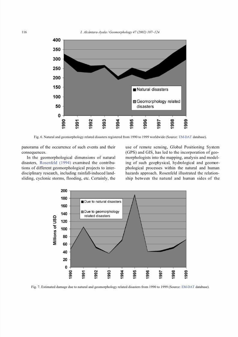
8102019 Articulo - Geomorphology Natural Hazards Vulnerability and Prevention of Natural Disasters in Developing Countrihellip
httpslidepdfcomreaderfullarticulo-geomorphology-natural-hazards-vulnerability-and-prevention-of 1018
panorama of the occurrence of such events and their
consequences
In the geomorphological dimensions of natural
disasters Rosenfeld (1994) examined the contribu-
tions of different geomorphological projects to inter-
disciplinary research including rainfall-induced land-
sliding cyclonic storms flooding etc Certainly the
use of remote sensing Global Positioning System
(GPS) and GIS has led to the incorporation of geo-
morphologists into the mapping analysis and model-
ing of such geophysical hydrological and geomor-
phological processes within the natural and human
hazards approach Rosenfeld illustrated the relation-
ship between the natural and human sides of the
Fig 6 Natural and geomorphology related disasters registered from 1990 to 1999 worldwide (Source EM-DAT database)
Fig 7 Estimated damage due to natural and geomorphology related disasters from 1990 to 1999 (Source EM-DAT database)
I Alca ntara-Ayala Geomorphology 47 (2002) 107ndash124116
8102019 Articulo - Geomorphology Natural Hazards Vulnerability and Prevention of Natural Disasters in Developing Countrihellip
httpslidepdfcomreaderfullarticulo-geomorphology-natural-hazards-vulnerability-and-prevention-of 1118
extent of natural hazards by using a pyramid-form
graph where the faces represent the duration and areal
extents of different hazards in terms of casualties and
hazard severity according to the different degree of
development of the countries and based on the level
response needed to cope with the disasters as a
function of economic development
By analyzing the EM-DAT database which
includes phenomena such as slides floods earth-
quakes volcanoes wind storms extreme tempera-
tures droughts wild fires and epidemics as natural
disasters it can be noticed that with exception of
extreme temperatures and epidemics all the other
ph en omen a are ge omor ph ol ogy rela te d Fig 5
presents the percentage of those disasters related to
geomorphology by type and region from 1900 to
1999 Between 1990 and 1999 2808 disasters were
recorded worldwide Eighty four percent of them wererelated to geomorphology (Fig 6) The total amount
of estimated damage (Fig 7) in relation to the global
natural disasters registered within the same period of
time and the number of people reported killed (Table
4) and affected (Fig 8) give a good indication of the
significance of geomorphology for the prevention of
natural disasters
The contribution of geomorphology to the field of
natural disasters is mainly through the elaboration of
hazard assessments In general such assessments
comprise stages like mapping modeling prediction
and management proposals using field observations
photogrammetry geographical information systems
and remote sensing the zonation and mapping of
different hazards is done Modeling approaches con-
sider not only the understanding of present but past
events leading to accurate predictions of the conse-
quences a geomorphic hazard may have on a deter-
mined landscape under a given conditions
Hazard assessment is a key part within the risk
analysis process Certainly geomorphologists have
contributed enormously on this matter Nevertheless
Table 4
Total number of people reported killed by continent and by type of
phenomenon from 1990 to 1999 (Source EM-DAT database)
Africa Americas Asia Europe Oceania Total
Slides 225 2010 5500 644 279 8658
Droughts 12 0 2680 0 98 2790
Earthquakes 816 3519 91878 2395 70 98678
Floods 9487 35598 55916 2839 30 103870
Wind Storms 1612 13264 185739 913 262 201790
Volcanoes 0 77 994 0 9 1080
Total 12152 54468 342707 6791 748 416866
Fig 8 People affected due to natural and geomorphology related disasters from 1990 to 1999 (Source EM-DAT database)
I Alca ntara-Ayala Geomorphology 47 (2002) 107ndash124 117
8102019 Articulo - Geomorphology Natural Hazards Vulnerability and Prevention of Natural Disasters in Developing Countrihellip
httpslidepdfcomreaderfullarticulo-geomorphology-natural-hazards-vulnerability-and-prevention-of 1218
a greater progress would be achieved if vulnerability
analysis were also taken into account
5 Geomorphology vulnerability and disasters
By examining the different definitions of natural
hazards and natural disasters it is clear that the
conceptualization has changed from a perspective of
a merely physical or natural event towards the inte-
gration of the human system Initially the uncontrol-
lable character of natural hazards directed efforts
towards coping with their impacts and also towards
the prediction of these events Technological advances
and the development of prediction models for vol-
canic activity hurricanes tsunamis flooding land-
sliding etc were developed seeking a better under-
standing of the phenomena and to some extent to offer
possibilities to cope with the impact of natural haz-
ards but mainly in lsquodeveloped countriesrsquo
Later in the 1960s the idea of the devastation by
natural disasters as a result of the social and economic
characteristics of the regions where natural hazards
took place was introduced (White 1961 1964 Kates
1962 Burton et al 1968 Hewitt and Burton 1971)
However it was not until the 1970s that the role of
economic and social conditions as factors of vulner-ability to natural disasters was acknowledged
The interest of understanding not only the natural
events per se but the characteristics of risk in the
areas prone to these phenomena has moved the
attention of many social scientists towards the study
of risk and vulnerability (eg Albala-Bertrand 1993
Blaikie et al 1994 Cannon 1993 Varley 1991
Winchester 1992) Previous investigations have
shown the need for defining and measuring hazard
events in a non-scientific (physical) view This
includes the description and analyses of different perceptions of hazard (Burton et al 1968) based on
the concept of differential perception of risk a very
important factor in the development of risk manage-
ment approaches
At the present time not only social scientists but
geoscientists are considering the socio-economic char-
acter of some regions prone to natural hazards as one
of the main factors of vulnerability to natural disasters
For instance Cardona (1997) considered the social
economic and institutional aspects within the manage-
ment of the crisis of Galer as volcano in Colombia
Dibben and Chester (1999) proposed a framework to
analyze human vulnerability in the case of Furnas
volcano in the Azores They recognized that peoplersquosvulnerability to volcanic hazards implies an interaction
of different elements related to the social context and
the corresponding physiological and psychological
characteristics In his overview of volcanic geomor-
phology Thouret (1999) pointed out that in order to
cope with the consequences of natural hazards and their
interaction with people living around the volcanoes
geomorphology is an essential part to undertake risk
assessment based on geomorphic hazard and risk
zonation
51 A closer look to vulnerability
The study of vulnerability related to natural disas-
ters has been the focus of different investigations and
hence of several definitions Westgate and OrsquoKeefe
(1976) defined vulnerability as the degree to which a
community is at risk from the occurrence of extreme
physical or natural phenomena where risk refers to the
probability of occurrence and the degree to which
socio-economic and socio-political factors affect the
communityrsquos capacity to absorb and recover from
extreme phenomena For Varley (1991) vulnerabilityis a function of the degree of social and self-protection
available to potential victims It is clearly related to the
ability of households or communities to cope with and
recover from outside events and particularly to shocks
and sudden changes (Maskey 1993) It also concerns
the predisposition of a society to experience substan-
tial damage as a result of natural hazards (Clarke and
Munasinghe 1995) These definitions imply that vul-
nerability is the result of the socio-economic and
political systems of the entity in danger However it
is the definition of Cannon (1993) which considersdifferent factors affecting or producing the vulnerabil-
ity of individuals or groups that is most germane
According to him vulnerability lsquolsquois a characteristic of
individuals and groups of people who inhabit a given
natural social and economic space within which they
are differentiated according to their varying position in
society into more or less vulnerable individuals and
groups It is a complex characteristics produced by a
combination of factors derived especially (but not
entirely) from class gender or ethnicityrsquorsquo Cannon
I Alca ntara-Ayala Geomorphology 47 (2002) 107ndash124118
8102019 Articulo - Geomorphology Natural Hazards Vulnerability and Prevention of Natural Disasters in Developing Countrihellip
httpslidepdfcomreaderfullarticulo-geomorphology-natural-hazards-vulnerability-and-prevention-of 1318
divided vulnerability into three parts (1) Livelihood
resilience the degree of resilience of the particular
livelihood system of an individual or group and their
capacity for resisting the impact of hazard (2) Healthincluding both the robustness of individuals and the
operation of various social measures (3) Preparedness
determined by the protection available for a given
hazard something that depends on people acting on
their own behalf and social factors
These three aspects cover a great proportion of the
different kinds of vulnerabilities Nevertheless each
aspect has different components and the combinations
of them can be so numerous that it is necessary to
specify the particular types of vulnerability of each
threatened entity The latter will provide an adequate
understanding of the total vulnerability to natural
disasters so that prevention can be effectively accom-
plished This insight strengthens the contribution of
Aysan (1993) who recognizes different kinds of
vulnerability as follows
Lack of access to resources (materialseconomic
vulnerability) Disintegration of social patterns (social vulnerabil-
ity) Lack of strong national and local institutional
structures (organizational vulnerability) Lack of access to information and knowledge
(educational vulnerability) Lack of public awareness (attitudinal and motiva-
tional vulnerability) Limited access to political power and representa-
tion (political vulnerability) Certain beliefs and customs (cultural vulner-
ability) Weak buildings of weak individuals (physical
vulnerability)
There are indeed many other kinds of vulnerability
However all of them can be inserted within four main
types of vulnerability social economic political and
cultural This classification indicates that each social
entity has different types of vulnerability and it is not
only the result of the human actions decisions and
choices it is the result of the interaction of the natural
economic social cultural and political contexts where
people live Vulnerability cannot be treated as a
homogeneous and general term its dynamism is given
by each society and it is both a universal and
particular concept There is certainly a differential
character of vulnerability Vulnerability is given by
t he coupling between the natural and human systems(Fig 9) In this sense vulnerability can be divided
into natural vulnerability and human vulnerability
Natural vulnerability depends on the threatening nat-
ural hazard (very much related to geographical loca-
tion) thus there is volcanic vulnerability flooding
vulnerability landsliding vulnerability tsunamis vul-
nerability hurricane vulnerability and so on On con-
trast human vulnerability is based on the social
economical political and cultural systems
Hence vulnerability can be defined as the propen-
sity of an endangered element due to any kind of
natural hazard to suffer different degrees of loss or
amount of damage depending on its particular social
economic cultural and political weaknesses Total
vulnerability is a function of the individual types of
vulnerability present in a given area Such vulnerabil-
ity determines the magnitude of the disaster the level
of resilience and the recovery process
52 A step forward into the prevention of natural
disasters applied geomorphology
The reduction of natural vulnerability could beobtained from an equal access to scientific informa-
tional resources and methodologies for the understand-
ing and prediction of natural hazards (eg state-of-art
predicting models) and to international training pro-
grams Natural hazards cannot be prevented but the
understanding of the process and scientific method-
ologies to predict patterns of behavior of such pro-
cesses can be powerful tools to help reduce natural
vulnerability
Geomorphological research can provide theoretical
and applied approaches to the prevention of naturaldisasters in terms of origin and dynamism of the
physical processes Furthermore geomorphologists
could also offer important contributions based on the
understanding of the interaction between natural haz-
ards (natural vulnerability) and the societies (human
vulnerability) Consequently they should be involved
to a greater extent in such tasks as is the case of the
contributions of D Alexander M Panizza and HT
Verstappenmdashto mention the most familiar examplesmdash
who not only have shed light on understanding geo-
I Alca ntara-Ayala Geomorphology 47 (2002) 107ndash124 119
8102019 Articulo - Geomorphology Natural Hazards Vulnerability and Prevention of Natural Disasters in Developing Countrihellip
httpslidepdfcomreaderfullarticulo-geomorphology-natural-hazards-vulnerability-and-prevention-of 1418
morphological processes but also on the strong link
between the processes and society
Geomorphology can be considered a strategic
discipline in the reduction of both human and natural
vulnerabilities By contributing to the understanding
of endogenetic and exogenetic processes method-
ologies to predict patterns of occurrence of hazardous
events can be developed and applied Geomorpholo-
gists assist in the reduction of natural vulnerability inthree different ways first by enriching the theoretical
knowledge of geomorphology which is the base of
the application of our discipline second by develop-
ing prediction models for different processes such as
landsliding flooding volcanism among others and
finally through diversified approaches of applied
geomorphology for the prevention of natural disas-
ters Indeed geomorphology is a powerful field that
must play a role in the interdisciplinary efforts to
develop adequate strategies for prevention and miti-
gation of natural disasters Nonetheless contributions
of geomorphology would be even more significant if
research applications were directed towards the
understanding and coupling of human and natural
vulnerabilities Reduction of natural disasters is a
complex task by nature however it is now clear
that a combination not only of social and scientific
knowledge but also of attitudes towards the elabo-
ration of adequate strategies based on vulnerabilityanalysis of the particular social entities is urgently
required
6 Conclusions
Natural hazards are threatening events capable of
producing damage to the physical and social space in
which they take place not only at the moment of their
occurrence but in the long-term due to their associ-
Fig 9 The ingredients of natural disasters
I Alca ntara-Ayala Geomorphology 47 (2002) 107ndash124120
8102019 Articulo - Geomorphology Natural Hazards Vulnerability and Prevention of Natural Disasters in Developing Countrihellip
httpslidepdfcomreaderfullarticulo-geomorphology-natural-hazards-vulnerability-and-prevention-of 1518
ated consequences When these consequences have an
impact on society andor infrastructure they become
natural disasters These can be considered as sudden
but expected (we all know that they occur) naturalevents which impact the human and natural systems
The degree of their impact in space and time is a
function of the exposure to and the magnitude of the
natural phenomena (natural vulnerability) and the
human vulnerability of the threatened entity
Natural disasters occur all over the world how-
ever their impact in developing countries is greater
due to the geographical location in zones highly
susceptible to natural hazards (natural vulnerability)
and also due to the different types of economic social
political and cultural vulnerabilities that exist These
vulnerabilities are indeed the result of their historical
development and their social political economic and
cultural contexts The rich get richer the poor poorer
and the access to opportunities within the social entity
are unequal and indirectly proportional to the occur-
rence of natural disasters (the less opportunities the
more vulnerability the more affected by natural dis-
asters)
The International Decade for Natural Disaster
Reduction (IDNDR) has achieved several goals such
as the organization of international groups to provide
advice on the prevention of natural disasters onregional and national bases Events such as Hurricane
Mitch in Central America (October 1998) the earth-
quake in Turkey (August 1999) and their devastating
consequences demonstrated that natural disasters
occur in places where the geographical coordinates
of natural and human vulnerabilities converge An
effort must be made to promote the elaboration of
vulnerability analysis within a risk assessment and
management framework where not only geomor-
phology but also geomorphologists play a key role
for the prevention of natural disasters The latter needs indeed to be more rapidly implemented in
developing countries
Acknowledgements
Natural disasters registered data were kindly
provided by the ODFACRED International Disaster
Database Center for Research into the Epidemiology of
Disasters (CRED) Catholic University of Louvain
Belgium (httpwwwmduclacbecred) and the Of-
fice of US Foreign Disaster Assistance (httpwww
usaidgovhum _ responseofda ) Thanks are also due to
BE Montz CL Rosenfeld and PLK Knuepfer for critical reviewing of this paper
References
Albala-Bertrand JM 1993 Political Economy of Large Natural
Disasters With Special Reference to Developing Countries Ox-
ford Univ Press London 259 pp
Alexander D 1993 Natural Disasters UCL Press and Chapman amp
Hall New York 632 pp
Al-Homoud AS Tubeileh T 1997 An inventory for evaluating
hazard and risk assessment of cut slopes in weak rocks along
highways Bull Int Assoc Eng Geol 55 39ndash51Anderson JL Decker RW 1992 Volcano risk mitigation
through training In McCall GJH Laming DJC Scott
SC (Eds) Geohazards Natural and Man-Made Chapman amp
Hall London pp 7 ndash 12
Anderson MG Collison AJC Hartshorne J Lloyd DM
Park A 1996 Developments in slope hydrology-stability mod-
eling for tropical slopes In Anderson MG Brooks SM
(Eds) Advances in Hillslope Processes vol 2 Wiley Chiches-
ter pp 799ndash821
Aysan YF 1993 Vulnerability assessment In Merriman PA
Browitt CWA (Eds) Natural Disasters Protecting Vulnerable
Communities Thomas Telford London pp 1 ndash 14
Baker VR 1994 Geomorphological understanding of floods Geo-
morphology 10 139ndash156
Barkun N 1974 Disaster and the Millenium Yale Univ Press
New Haven
Bates PD De Roo APJ 2000 A simple raster-based model for
flood inundation simulation J Hydrol 236 54ndash77
Blaikie P Cannon T Davis I Wisner B 1994 At Risk Natural
Hazards Peoplersquos Vulnerability and Disasters Routledge Lon-
don 284 pp
Brooks SM Collison AJC 1996 The significance of soil pro-
file differentiation to hydrological response and slope instability
a modeling approach In Anderson MG Brooks SM (Eds)
Advances in Hillslope Processes vol 2 Wiley Chichester pp
471ndash486
Brunsden D 1993 Mass movement the research frontier and bey ond a geomor phological approa ch Geom orp hology 7
85ndash128
Brunsden D 1999 Some geomorphological considerations for the
future development of landslide models Geomorphology 30
13ndash24
Burton I Kates RW 1964 The perception of natural hazards in
resource management Nat Resour J 3 412ndash441
Burton I Kates RW White GF 1968 The Human Ecology of
Extreme Geophysical Events Department of Geography Natu-
ral Hazards Research Working Paper No 1 University of Tor-
onto
Cannon T 1993 A hazard need not a disaster make vulnerability
I Alca ntara-Ayala Geomorphology 47 (2002) 107ndash124 121
8102019 Articulo - Geomorphology Natural Hazards Vulnerability and Prevention of Natural Disasters in Developing Countrihellip
httpslidepdfcomreaderfullarticulo-geomorphology-natural-hazards-vulnerability-and-prevention-of 1618
and the causes of lsquonaturalrsquo disasters In Merriman PA Bro-
witt CWA (Eds) Natural Disasters Protecting Vulnerable
Communities Thomas Telford London pp 92ndash 105
Canuti P Focardi P Garzonia CA Rodolfi G Vannocci P
1987 Slope stability mapping in Tuscany Italy In Gardiner V(Ed) International Geomorphology 1986 Part I Wiley London
pp 231 ndash 240
Cardona OD 1997 Management of the volcanic crises of Galeras
volcano social economic and institutional aspects J Volcanol
Geother Res 77 313ndash324
Carrara A Cardinali M Detti R Guzzetti F Pasqui V Reich-
enbach P 1990 Geographical information systems and multi-
variate models in landslide hazard evaluation In Cancelli A
(Ed) Alps 90 Int Conf and Field Workshop on Landslides
Milano pp 17ndash 28
CEPAL 1999 Central America Assessment of the Damage Caused
by Hurricane Mitch 1998 Implications for Economic and So-
cial Development and for the Environment 41 pp At http
wwwcepalorgmx
Chacon J Irigaray C El Hamdouni R Fernandez T 1996
From the inventory to the risk analisis improvements to a large
scale GIS method In Chacon J Irigaray C Fernandez T
(Eds) Landslides Balkema Rotterdam pp 335ndash342
Chandler JH Brunsden D 1995 Steady state behaviour of the
Black Ven mudslide the application of archival analytical pho-
togrammetry to studies of landform change Earth Surf Pro-
cesses Landf 20 255ndash275
Chandler JH Cooper MAR 1989 The extraction of positional
data from historical photographs and their application in geo-
morphology Photogramm Rec 13 (73) 69 ndash 78
Chandler JH Moore R 1989 Analytical photogrammetry a
method for monitoring slope instability Q J Eng Geol 2297ndash110
Chang TJ Hsu MH Teng WH Huang CJ 2000 A GIS-
assisted distributed watershed model for simulating flooding and
inundation J Am Wat Resour Assoc 36 (5) 975 ndash 988
Chowdhury MR 2000 An assessment of flood forecasting in
Bangladesh the experience of the 1998 flood Nat Hazards
22 (2) 139ndash163
Clarke C Munasinghe M 1995 Economic aspects of disasters
and sustainable development an introduction In Munasinghe
M Clarke C (Eds) Disaster Prevention for Sustainable De-
velopment Economy and Policy Issues IDNDR and the World
Bank Washington pp 1ndash10
Collison AJC Anderson MG 1996 Using a combined slope
hydrology-slope stability model to identify suitable conditionsfor landslide prevention by vegetation in the humid tropics
Earth Surf Processes Landf 21 (8) 737ndash747
Collison AJC Anderson MG Lloyd DM 1995 The impact
of vegetation on slope stability in a humid tropical environment
a modeling approach Inst Civil Eng Water Marit Energy 112
168ndash175
Corominas J Moya J 1996 Historical landslides in the eastern
Pyrenees and their relation to rainy events In Chacon J Iri-
garay C Fernandez T (Eds) Landslides Balkema Rotter-
dam pp 125ndash132
Dibben C Chester DK 1999 Human vulnerability in volcanic
environments the case of Furnas Sao Miguel Azores J Vol-
canol Geother Res 92 (1ndash2) 133ndash150
Dikau R Jaeger S 1993 The role of geomorphology in regional
landslide hazard assessment using GIS technologies In Reich-
enbach P Guzzetti F Carrara A (Eds) Workshop on Geo-graphic Information Systems in Assessing Natural Hazards
Univ Foreigners Perugia Italy pp 54 ndash 55
Dikau R Cavallin A Jaeger S 1992 Database and GIS for
landslide research in Europe In Casale R Fantechi R Flag-
eollet JC (Eds) Temporal Occurrence and Forecasting of
Landslides in the European Community Final Report vol 1
pp 97 ndash 116
Domınguez-Cuesta MJ Jimınez-Sanchez M Rodrıguez-Garcıa
A 1999 Press archives as temporal records of landslides in the
north of Spain relationships between rainfall and instability
slope events Geomorphology 30 125ndash132
Dowdeswell JA Lamb HF Lewin J 1988 Failure and flow on
a 35 degrees slope causes and three-dimensional observations
Earth Surf Processes Landf 13 737ndash746
Elsinga RJ Verstappen HT 1988 SPOT for earthquake hazard
zoning in southern Italy SPOT 1 Image utilization assessment
results Techniques Spatiales 1 Centre National drsquoEtudes Spa-
tiales Toulouse France pp 199ndash207
EM-DAT The OFDACRED International Disaster Database At
httpwwwcredbeemdat Universite Catholique de Louvain
Brussels Belgium
Enzel Y Wells SG 1997 Extracting Holocene paleohydrology
and paleoclimatology information from modern extreme flood
events an example from Southern California Geomorphology
19 203ndash226
Enzel Y Ely LL House PK Baker VR Webb RH 1993
Paleoflood evidence for a natural upper bound to flood magni-tudes in the Colorado River Water Resour Res 29 (7) 2287ndash
2297
Erdik M Biro YA Onur T Sesetyan K Birgoren G 1999
Assessment of earthquake hazard in Turkey and neighboring
regions Ann Geofis 42 1125ndash1138
Fritz CE 1961 Disasters In Merton RK Nisbet RA (Eds)
Contemporary Social Problems Harcourt New York pp 651ndash
694
Galadini F Galli P 2000 Active tectonics in the central Apen-
nines (Italy)mdashinput data for seismic hazard assessment Nat
Hazards 22 (3) 225ndash270
Gares PA Sherman DJ Nordstrom KF 1994 Geomorphology
and natural hazards Geomorphology 10 1ndash18
Gili JA Corominas J Rius J 2000 Using global positioningsystem techniques in landslide monitoring Eng Geol 55 (3)
167ndash192
Gomez-Fernandez F 2000 Contribution of geographical informa-
tion systems to the management of volcanic crises Nat Hazards
21 (2ndash 3) 347ndash 360
Guzzetti F Cardinali M Reichenbach P 1994 The AVI project
a bibliographical and archive inventory of landslides and floods
in Italy Environ Manage 18 (4) 623ndash633
Hansen A 1984 Landslide hazard analysis In Brunsden D
Prior DB (Eds) Slope Instability Wiley Chichester pp
523ndash602
I Alcantara-Ayala Geomorphology 47 (2002) 107ndash124122
8102019 Articulo - Geomorphology Natural Hazards Vulnerability and Prevention of Natural Disasters in Developing Countrihellip
httpslidepdfcomreaderfullarticulo-geomorphology-natural-hazards-vulnerability-and-prevention-of 1718
Hewitt K Burton I 1971 The Hazardousness of a Place A
Regional Ecology of Damaging Events Research Paper No 6
Department of Geography University of Toronto
Hutchinson JN 1992 Landslide Hazard Assessment Proc 6th
Int Symp on Landslides Christchurch New Zealand vol 3 pp 3 ndash 35
Ibsen ML Brunsden D 1996 The nature use and problems of
historical archives for the temporal occurrence of landslides
with specific reference to the south coast of Britain Ventnor
Isle of Wight Geomorphology 15 241ndash258
IDNDR 1992 Glossary Internationally Agreed Glossary of Basic
Terms Related to Disaster Management DHA-Geneva 83 pp
Islam MDM Sado K 2000 Development of flood hazard maps
of Bangladesh using NOAA-AVHRR images with GIS Hydrol
Sci J 45 337ndash355
Jenkins A Ashworth PJ Ferguson RI Grieve IC Rowling
P Stott TA 1988 Slope failures in the Ochil Hills Scotland
November 1984 Earth Surf Processes Landf 13 69 ndash 76
Kale VS Ely LL Enzel Y Baker VR 1994 Geomorphic and
hydrologic aspects of monsoon floods on the Narmada and Tapi
Rivers in central India Geomorphology 10 157ndash168
Kale VS Hire P Baker VR 1997 Flood hydrology and geo-
morphology of monsoon-dominated rivers the Indian Peninsu-
la Water Int 22 259ndash265
Kates RW 1962 Hazard and Choice Perception in Flood Plain
Management Research Paper No 78 Department of Geogra-
phy University of Chicago
Leroi E 1997 Landslide risk mapping problems limitations and
developments In Cruden DM Fell R (Eds) Landslide Risk
Assessment Balkema Rotterdam pp 239 ndash 250
Mantovani F Soeters R Van Westen CJ 1996 Remote sensing
techniques for landslide studies and hazard zonation in EuropeGeomorphology 15 213ndash225
Maskey A 1993 Vulnerability accumulation in peripheral regions
in Latin America the challenge for disaster prevention and
management In Merriman PA Browitt CWA (Eds) Nat-
ural Disasters Protecting Vulnerable Communities Thomas
Telford London pp 461ndash472
Merzi N Aktas MT 2000 Geographic information systems
(GIS) for the determination of inundation maps of Lake Mogan
Turkey Water Int 25 (3) 474ndash480
Montgomery DR Dietrich WE 1994 A physically based model
for the topographic control on shallow landsliding Water Re-
sour Res 30 (4) 1153ndash1171
Okuda S 1970 On the relation between physical geomorphology
and the science of natural disasters Bull Disaster Prev ResInst 19 (25) Part 5 Kyoto Japan
Ordaz M Reyes C 1999 Earthquake hazard in Mexico City
observations versus computations Bull Seismol Soc Am 89
(5) 1379ndash 1383
Panizza M 1981 Geomorphology and earthquake hazard in envi-
ronmental planning In Palmentola G Acquafredda P (Eds)
Proceedings of the International Conference on Seismic Zones
in the Mediterranean Area Basilicata Italy pp 203ndash207
Panizza M 1991 Geomorphology and seismic risk Earth-Sci
Rev 31 (1) 11ndash20
Pareschi MT Cavarra L Favalli M Giannini F Meriggi A
2000 GIS and volcanic risk management Nat Hazards 21 (2ndash
3) 361ndash379
Petley DN 1998 Geomorphological mapping for hazard assess-
ment in a neotectonic terrain Geogr J 164 (7) 183ndash201
Proske H 1996 GIS supported analysis of effects of joint systemson shallow landslides in a tectonically complex crystalline
catchment area In Chacon J Irigaray C Fernandez T
(Eds) Landslides Balkema Rotterdam pp 173ndash180
Rosenfeld CL 1994 The geomorphological dimensions of natural
disasters Geomorphology 10 27ndash36
Scheidegger AE 1994 Hazards singularities in geomorphic sys-
tems Geomorphology 10 19ndash25
Siegel H Gerth M 2000 Satellite-based studies of the 1997 Oder
flood event in the southern Baltic Sea Remote Sens Environ
73 (2) 207ndash217
Singhroy V Mattar KE Gray AL 1998 Landslide character-
isation in Canada using interferometric SAR and combined SAR
and TM images Adv Space Res 21 (3) 465ndash476
Slaymaker O 1996 Introduction In Slaymaker O (Ed) Geo-
morphic Hazards Wiley Chichester pp 1ndash7
Sousa J Voight B 1992 Computational flow modeling for long-
runout landslide hazard assessment with an example from Cla-
piere landslide France Bull Assoc Eng Geol 29 (2) 131 ndash
150
Summerfield MA 1991 Global Geomorphology An Introduction
to the Study of Landforms Wiley New York 537 pp
Terlien MTJ 1996 The prediction of rainfall-triggered soil slips
in Manizales (Colombia) In Chacon J Irigaray C Fernan-
dez T (Eds) Landslides Balkema Rotterdam pp 197 ndash 205
Thornes JB Alcantara-Ayala I 1998 Modelling mass failure in a
Mediterranean mountain environment climatic geological
topographical and erosional controls Geomorphology 24 87ndash 100
Thouret JC 1999 Urban hazards and risks consequences of
earthquakes and volcanic eruptions an introduction GeoJournal
49 (2) 131ndash135
Tobin GA Montz BE 1997 Natural Hazards Explanation and
Integration The Guilford Press New York 388 pp
UNDRO 1982 Natural Disasters and Vulnerability Analysis Of-
fice of the United Nations Disaster Relief Coordinator Geneva
Switzerland
Van Asch TWJ Buma JT 1997 Modelling groundwater fluc-
tuations and the frequency of movement of a landslide in the
Terres Noires region of Barcelonnette (France) Earth Surf Pro-
cesses Landf 22 131ndash141
Varley A 1991 Disasters vulnerability and response Disasters 15(3) 285ndash287
Verstappen HT 1988 Geomorphological surveys and natural haz-
ard zoning with special reference to volcanic hazards in central
Java Z Geomorphol Supplbd 68 81ndash101
Verstappen HT 1989 Geomorphology natural disasters and glob-
al change Symposium on Aerospace Survey and Natural Dis-
asters ITC J (3ndash4) 159ndash164
Verstappen HT 1992 Volcanic hazards in Colombia and Indone-
sia lahars and related phenomena In McCall GJH Laming
DDC Scott SC (Eds) Geohazards Natural and Man-Made
Chapman amp Hall London pp 33ndash42
I Alcantara-Ayala Geomorphology 47 (2002) 107ndash124 123
8102019 Articulo - Geomorphology Natural Hazards Vulnerability and Prevention of Natural Disasters in Developing Countrihellip
httpslidepdfcomreaderfullarticulo-geomorphology-natural-hazards-vulnerability-and-prevention-of 1818
Westgate KN OrsquoKeefe P 1976 Some Definitions of Disaster
Disaster Research Unit Occasional Paper No 4 Department of
Geography University of Bradford
White GF (Ed) 1961 Papers on Flood Problems Research Pa-
pers No 70 Department of Geography University of ChicagoWhite GF 1964 Choice of Adjustments to Floods Research Pa-
per No 93 Department of Geography University of Chicago
White GF 1973 Natural hazards research In Chorley RJ (Ed)
Directions in Geography Methuen London pp 193 ndash 216
Winchester P 1992 Power Choice and Vulnerability A Case
Study in Disaster Management in South India James amp James
London 225 pp
Wolman MG Miller JP 1960 Magnitude and frequency of
forces in geomorphic processes J Geol 68 (1) 54ndash74
Yin KL 1994 A computer-assisted mapping of landslide hazardevaluation 7th International IAEG Congress Balkema Rotter-
dam pp 4495ndash 4499
Zhou CH Luo JC Yang CJ Li BL Wang SL 2000 Flood
monitoring using multi-temporal AVHRR and RADARSAT im-
agery Photogramm Eng Remote Sensing 66 (5) 633ndash638
I Alca ntara-Ayala Geomorphology 47 (2002) 107ndash124124
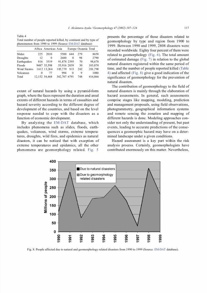
8102019 Articulo - Geomorphology Natural Hazards Vulnerability and Prevention of Natural Disasters in Developing Countrihellip
httpslidepdfcomreaderfullarticulo-geomorphology-natural-hazards-vulnerability-and-prevention-of 1118
extent of natural hazards by using a pyramid-form
graph where the faces represent the duration and areal
extents of different hazards in terms of casualties and
hazard severity according to the different degree of
development of the countries and based on the level
response needed to cope with the disasters as a
function of economic development
By analyzing the EM-DAT database which
includes phenomena such as slides floods earth-
quakes volcanoes wind storms extreme tempera-
tures droughts wild fires and epidemics as natural
disasters it can be noticed that with exception of
extreme temperatures and epidemics all the other
ph en omen a are ge omor ph ol ogy rela te d Fig 5
presents the percentage of those disasters related to
geomorphology by type and region from 1900 to
1999 Between 1990 and 1999 2808 disasters were
recorded worldwide Eighty four percent of them wererelated to geomorphology (Fig 6) The total amount
of estimated damage (Fig 7) in relation to the global
natural disasters registered within the same period of
time and the number of people reported killed (Table
4) and affected (Fig 8) give a good indication of the
significance of geomorphology for the prevention of
natural disasters
The contribution of geomorphology to the field of
natural disasters is mainly through the elaboration of
hazard assessments In general such assessments
comprise stages like mapping modeling prediction
and management proposals using field observations
photogrammetry geographical information systems
and remote sensing the zonation and mapping of
different hazards is done Modeling approaches con-
sider not only the understanding of present but past
events leading to accurate predictions of the conse-
quences a geomorphic hazard may have on a deter-
mined landscape under a given conditions
Hazard assessment is a key part within the risk
analysis process Certainly geomorphologists have
contributed enormously on this matter Nevertheless
Table 4
Total number of people reported killed by continent and by type of
phenomenon from 1990 to 1999 (Source EM-DAT database)
Africa Americas Asia Europe Oceania Total
Slides 225 2010 5500 644 279 8658
Droughts 12 0 2680 0 98 2790
Earthquakes 816 3519 91878 2395 70 98678
Floods 9487 35598 55916 2839 30 103870
Wind Storms 1612 13264 185739 913 262 201790
Volcanoes 0 77 994 0 9 1080
Total 12152 54468 342707 6791 748 416866
Fig 8 People affected due to natural and geomorphology related disasters from 1990 to 1999 (Source EM-DAT database)
I Alca ntara-Ayala Geomorphology 47 (2002) 107ndash124 117
8102019 Articulo - Geomorphology Natural Hazards Vulnerability and Prevention of Natural Disasters in Developing Countrihellip
httpslidepdfcomreaderfullarticulo-geomorphology-natural-hazards-vulnerability-and-prevention-of 1218
a greater progress would be achieved if vulnerability
analysis were also taken into account
5 Geomorphology vulnerability and disasters
By examining the different definitions of natural
hazards and natural disasters it is clear that the
conceptualization has changed from a perspective of
a merely physical or natural event towards the inte-
gration of the human system Initially the uncontrol-
lable character of natural hazards directed efforts
towards coping with their impacts and also towards
the prediction of these events Technological advances
and the development of prediction models for vol-
canic activity hurricanes tsunamis flooding land-
sliding etc were developed seeking a better under-
standing of the phenomena and to some extent to offer
possibilities to cope with the impact of natural haz-
ards but mainly in lsquodeveloped countriesrsquo
Later in the 1960s the idea of the devastation by
natural disasters as a result of the social and economic
characteristics of the regions where natural hazards
took place was introduced (White 1961 1964 Kates
1962 Burton et al 1968 Hewitt and Burton 1971)
However it was not until the 1970s that the role of
economic and social conditions as factors of vulner-ability to natural disasters was acknowledged
The interest of understanding not only the natural
events per se but the characteristics of risk in the
areas prone to these phenomena has moved the
attention of many social scientists towards the study
of risk and vulnerability (eg Albala-Bertrand 1993
Blaikie et al 1994 Cannon 1993 Varley 1991
Winchester 1992) Previous investigations have
shown the need for defining and measuring hazard
events in a non-scientific (physical) view This
includes the description and analyses of different perceptions of hazard (Burton et al 1968) based on
the concept of differential perception of risk a very
important factor in the development of risk manage-
ment approaches
At the present time not only social scientists but
geoscientists are considering the socio-economic char-
acter of some regions prone to natural hazards as one
of the main factors of vulnerability to natural disasters
For instance Cardona (1997) considered the social
economic and institutional aspects within the manage-
ment of the crisis of Galer as volcano in Colombia
Dibben and Chester (1999) proposed a framework to
analyze human vulnerability in the case of Furnas
volcano in the Azores They recognized that peoplersquosvulnerability to volcanic hazards implies an interaction
of different elements related to the social context and
the corresponding physiological and psychological
characteristics In his overview of volcanic geomor-
phology Thouret (1999) pointed out that in order to
cope with the consequences of natural hazards and their
interaction with people living around the volcanoes
geomorphology is an essential part to undertake risk
assessment based on geomorphic hazard and risk
zonation
51 A closer look to vulnerability
The study of vulnerability related to natural disas-
ters has been the focus of different investigations and
hence of several definitions Westgate and OrsquoKeefe
(1976) defined vulnerability as the degree to which a
community is at risk from the occurrence of extreme
physical or natural phenomena where risk refers to the
probability of occurrence and the degree to which
socio-economic and socio-political factors affect the
communityrsquos capacity to absorb and recover from
extreme phenomena For Varley (1991) vulnerabilityis a function of the degree of social and self-protection
available to potential victims It is clearly related to the
ability of households or communities to cope with and
recover from outside events and particularly to shocks
and sudden changes (Maskey 1993) It also concerns
the predisposition of a society to experience substan-
tial damage as a result of natural hazards (Clarke and
Munasinghe 1995) These definitions imply that vul-
nerability is the result of the socio-economic and
political systems of the entity in danger However it
is the definition of Cannon (1993) which considersdifferent factors affecting or producing the vulnerabil-
ity of individuals or groups that is most germane
According to him vulnerability lsquolsquois a characteristic of
individuals and groups of people who inhabit a given
natural social and economic space within which they
are differentiated according to their varying position in
society into more or less vulnerable individuals and
groups It is a complex characteristics produced by a
combination of factors derived especially (but not
entirely) from class gender or ethnicityrsquorsquo Cannon
I Alca ntara-Ayala Geomorphology 47 (2002) 107ndash124118
8102019 Articulo - Geomorphology Natural Hazards Vulnerability and Prevention of Natural Disasters in Developing Countrihellip
httpslidepdfcomreaderfullarticulo-geomorphology-natural-hazards-vulnerability-and-prevention-of 1318
divided vulnerability into three parts (1) Livelihood
resilience the degree of resilience of the particular
livelihood system of an individual or group and their
capacity for resisting the impact of hazard (2) Healthincluding both the robustness of individuals and the
operation of various social measures (3) Preparedness
determined by the protection available for a given
hazard something that depends on people acting on
their own behalf and social factors
These three aspects cover a great proportion of the
different kinds of vulnerabilities Nevertheless each
aspect has different components and the combinations
of them can be so numerous that it is necessary to
specify the particular types of vulnerability of each
threatened entity The latter will provide an adequate
understanding of the total vulnerability to natural
disasters so that prevention can be effectively accom-
plished This insight strengthens the contribution of
Aysan (1993) who recognizes different kinds of
vulnerability as follows
Lack of access to resources (materialseconomic
vulnerability) Disintegration of social patterns (social vulnerabil-
ity) Lack of strong national and local institutional
structures (organizational vulnerability) Lack of access to information and knowledge
(educational vulnerability) Lack of public awareness (attitudinal and motiva-
tional vulnerability) Limited access to political power and representa-
tion (political vulnerability) Certain beliefs and customs (cultural vulner-
ability) Weak buildings of weak individuals (physical
vulnerability)
There are indeed many other kinds of vulnerability
However all of them can be inserted within four main
types of vulnerability social economic political and
cultural This classification indicates that each social
entity has different types of vulnerability and it is not
only the result of the human actions decisions and
choices it is the result of the interaction of the natural
economic social cultural and political contexts where
people live Vulnerability cannot be treated as a
homogeneous and general term its dynamism is given
by each society and it is both a universal and
particular concept There is certainly a differential
character of vulnerability Vulnerability is given by
t he coupling between the natural and human systems(Fig 9) In this sense vulnerability can be divided
into natural vulnerability and human vulnerability
Natural vulnerability depends on the threatening nat-
ural hazard (very much related to geographical loca-
tion) thus there is volcanic vulnerability flooding
vulnerability landsliding vulnerability tsunamis vul-
nerability hurricane vulnerability and so on On con-
trast human vulnerability is based on the social
economical political and cultural systems
Hence vulnerability can be defined as the propen-
sity of an endangered element due to any kind of
natural hazard to suffer different degrees of loss or
amount of damage depending on its particular social
economic cultural and political weaknesses Total
vulnerability is a function of the individual types of
vulnerability present in a given area Such vulnerabil-
ity determines the magnitude of the disaster the level
of resilience and the recovery process
52 A step forward into the prevention of natural
disasters applied geomorphology
The reduction of natural vulnerability could beobtained from an equal access to scientific informa-
tional resources and methodologies for the understand-
ing and prediction of natural hazards (eg state-of-art
predicting models) and to international training pro-
grams Natural hazards cannot be prevented but the
understanding of the process and scientific method-
ologies to predict patterns of behavior of such pro-
cesses can be powerful tools to help reduce natural
vulnerability
Geomorphological research can provide theoretical
and applied approaches to the prevention of naturaldisasters in terms of origin and dynamism of the
physical processes Furthermore geomorphologists
could also offer important contributions based on the
understanding of the interaction between natural haz-
ards (natural vulnerability) and the societies (human
vulnerability) Consequently they should be involved
to a greater extent in such tasks as is the case of the
contributions of D Alexander M Panizza and HT
Verstappenmdashto mention the most familiar examplesmdash
who not only have shed light on understanding geo-
I Alca ntara-Ayala Geomorphology 47 (2002) 107ndash124 119
8102019 Articulo - Geomorphology Natural Hazards Vulnerability and Prevention of Natural Disasters in Developing Countrihellip
httpslidepdfcomreaderfullarticulo-geomorphology-natural-hazards-vulnerability-and-prevention-of 1418
morphological processes but also on the strong link
between the processes and society
Geomorphology can be considered a strategic
discipline in the reduction of both human and natural
vulnerabilities By contributing to the understanding
of endogenetic and exogenetic processes method-
ologies to predict patterns of occurrence of hazardous
events can be developed and applied Geomorpholo-
gists assist in the reduction of natural vulnerability inthree different ways first by enriching the theoretical
knowledge of geomorphology which is the base of
the application of our discipline second by develop-
ing prediction models for different processes such as
landsliding flooding volcanism among others and
finally through diversified approaches of applied
geomorphology for the prevention of natural disas-
ters Indeed geomorphology is a powerful field that
must play a role in the interdisciplinary efforts to
develop adequate strategies for prevention and miti-
gation of natural disasters Nonetheless contributions
of geomorphology would be even more significant if
research applications were directed towards the
understanding and coupling of human and natural
vulnerabilities Reduction of natural disasters is a
complex task by nature however it is now clear
that a combination not only of social and scientific
knowledge but also of attitudes towards the elabo-
ration of adequate strategies based on vulnerabilityanalysis of the particular social entities is urgently
required
6 Conclusions
Natural hazards are threatening events capable of
producing damage to the physical and social space in
which they take place not only at the moment of their
occurrence but in the long-term due to their associ-
Fig 9 The ingredients of natural disasters
I Alca ntara-Ayala Geomorphology 47 (2002) 107ndash124120
8102019 Articulo - Geomorphology Natural Hazards Vulnerability and Prevention of Natural Disasters in Developing Countrihellip
httpslidepdfcomreaderfullarticulo-geomorphology-natural-hazards-vulnerability-and-prevention-of 1518
ated consequences When these consequences have an
impact on society andor infrastructure they become
natural disasters These can be considered as sudden
but expected (we all know that they occur) naturalevents which impact the human and natural systems
The degree of their impact in space and time is a
function of the exposure to and the magnitude of the
natural phenomena (natural vulnerability) and the
human vulnerability of the threatened entity
Natural disasters occur all over the world how-
ever their impact in developing countries is greater
due to the geographical location in zones highly
susceptible to natural hazards (natural vulnerability)
and also due to the different types of economic social
political and cultural vulnerabilities that exist These
vulnerabilities are indeed the result of their historical
development and their social political economic and
cultural contexts The rich get richer the poor poorer
and the access to opportunities within the social entity
are unequal and indirectly proportional to the occur-
rence of natural disasters (the less opportunities the
more vulnerability the more affected by natural dis-
asters)
The International Decade for Natural Disaster
Reduction (IDNDR) has achieved several goals such
as the organization of international groups to provide
advice on the prevention of natural disasters onregional and national bases Events such as Hurricane
Mitch in Central America (October 1998) the earth-
quake in Turkey (August 1999) and their devastating
consequences demonstrated that natural disasters
occur in places where the geographical coordinates
of natural and human vulnerabilities converge An
effort must be made to promote the elaboration of
vulnerability analysis within a risk assessment and
management framework where not only geomor-
phology but also geomorphologists play a key role
for the prevention of natural disasters The latter needs indeed to be more rapidly implemented in
developing countries
Acknowledgements
Natural disasters registered data were kindly
provided by the ODFACRED International Disaster
Database Center for Research into the Epidemiology of
Disasters (CRED) Catholic University of Louvain
Belgium (httpwwwmduclacbecred) and the Of-
fice of US Foreign Disaster Assistance (httpwww
usaidgovhum _ responseofda ) Thanks are also due to
BE Montz CL Rosenfeld and PLK Knuepfer for critical reviewing of this paper
References
Albala-Bertrand JM 1993 Political Economy of Large Natural
Disasters With Special Reference to Developing Countries Ox-
ford Univ Press London 259 pp
Alexander D 1993 Natural Disasters UCL Press and Chapman amp
Hall New York 632 pp
Al-Homoud AS Tubeileh T 1997 An inventory for evaluating
hazard and risk assessment of cut slopes in weak rocks along
highways Bull Int Assoc Eng Geol 55 39ndash51Anderson JL Decker RW 1992 Volcano risk mitigation
through training In McCall GJH Laming DJC Scott
SC (Eds) Geohazards Natural and Man-Made Chapman amp
Hall London pp 7 ndash 12
Anderson MG Collison AJC Hartshorne J Lloyd DM
Park A 1996 Developments in slope hydrology-stability mod-
eling for tropical slopes In Anderson MG Brooks SM
(Eds) Advances in Hillslope Processes vol 2 Wiley Chiches-
ter pp 799ndash821
Aysan YF 1993 Vulnerability assessment In Merriman PA
Browitt CWA (Eds) Natural Disasters Protecting Vulnerable
Communities Thomas Telford London pp 1 ndash 14
Baker VR 1994 Geomorphological understanding of floods Geo-
morphology 10 139ndash156
Barkun N 1974 Disaster and the Millenium Yale Univ Press
New Haven
Bates PD De Roo APJ 2000 A simple raster-based model for
flood inundation simulation J Hydrol 236 54ndash77
Blaikie P Cannon T Davis I Wisner B 1994 At Risk Natural
Hazards Peoplersquos Vulnerability and Disasters Routledge Lon-
don 284 pp
Brooks SM Collison AJC 1996 The significance of soil pro-
file differentiation to hydrological response and slope instability
a modeling approach In Anderson MG Brooks SM (Eds)
Advances in Hillslope Processes vol 2 Wiley Chichester pp
471ndash486
Brunsden D 1993 Mass movement the research frontier and bey ond a geomor phological approa ch Geom orp hology 7
85ndash128
Brunsden D 1999 Some geomorphological considerations for the
future development of landslide models Geomorphology 30
13ndash24
Burton I Kates RW 1964 The perception of natural hazards in
resource management Nat Resour J 3 412ndash441
Burton I Kates RW White GF 1968 The Human Ecology of
Extreme Geophysical Events Department of Geography Natu-
ral Hazards Research Working Paper No 1 University of Tor-
onto
Cannon T 1993 A hazard need not a disaster make vulnerability
I Alca ntara-Ayala Geomorphology 47 (2002) 107ndash124 121
8102019 Articulo - Geomorphology Natural Hazards Vulnerability and Prevention of Natural Disasters in Developing Countrihellip
httpslidepdfcomreaderfullarticulo-geomorphology-natural-hazards-vulnerability-and-prevention-of 1618
and the causes of lsquonaturalrsquo disasters In Merriman PA Bro-
witt CWA (Eds) Natural Disasters Protecting Vulnerable
Communities Thomas Telford London pp 92ndash 105
Canuti P Focardi P Garzonia CA Rodolfi G Vannocci P
1987 Slope stability mapping in Tuscany Italy In Gardiner V(Ed) International Geomorphology 1986 Part I Wiley London
pp 231 ndash 240
Cardona OD 1997 Management of the volcanic crises of Galeras
volcano social economic and institutional aspects J Volcanol
Geother Res 77 313ndash324
Carrara A Cardinali M Detti R Guzzetti F Pasqui V Reich-
enbach P 1990 Geographical information systems and multi-
variate models in landslide hazard evaluation In Cancelli A
(Ed) Alps 90 Int Conf and Field Workshop on Landslides
Milano pp 17ndash 28
CEPAL 1999 Central America Assessment of the Damage Caused
by Hurricane Mitch 1998 Implications for Economic and So-
cial Development and for the Environment 41 pp At http
wwwcepalorgmx
Chacon J Irigaray C El Hamdouni R Fernandez T 1996
From the inventory to the risk analisis improvements to a large
scale GIS method In Chacon J Irigaray C Fernandez T
(Eds) Landslides Balkema Rotterdam pp 335ndash342
Chandler JH Brunsden D 1995 Steady state behaviour of the
Black Ven mudslide the application of archival analytical pho-
togrammetry to studies of landform change Earth Surf Pro-
cesses Landf 20 255ndash275
Chandler JH Cooper MAR 1989 The extraction of positional
data from historical photographs and their application in geo-
morphology Photogramm Rec 13 (73) 69 ndash 78
Chandler JH Moore R 1989 Analytical photogrammetry a
method for monitoring slope instability Q J Eng Geol 2297ndash110
Chang TJ Hsu MH Teng WH Huang CJ 2000 A GIS-
assisted distributed watershed model for simulating flooding and
inundation J Am Wat Resour Assoc 36 (5) 975 ndash 988
Chowdhury MR 2000 An assessment of flood forecasting in
Bangladesh the experience of the 1998 flood Nat Hazards
22 (2) 139ndash163
Clarke C Munasinghe M 1995 Economic aspects of disasters
and sustainable development an introduction In Munasinghe
M Clarke C (Eds) Disaster Prevention for Sustainable De-
velopment Economy and Policy Issues IDNDR and the World
Bank Washington pp 1ndash10
Collison AJC Anderson MG 1996 Using a combined slope
hydrology-slope stability model to identify suitable conditionsfor landslide prevention by vegetation in the humid tropics
Earth Surf Processes Landf 21 (8) 737ndash747
Collison AJC Anderson MG Lloyd DM 1995 The impact
of vegetation on slope stability in a humid tropical environment
a modeling approach Inst Civil Eng Water Marit Energy 112
168ndash175
Corominas J Moya J 1996 Historical landslides in the eastern
Pyrenees and their relation to rainy events In Chacon J Iri-
garay C Fernandez T (Eds) Landslides Balkema Rotter-
dam pp 125ndash132
Dibben C Chester DK 1999 Human vulnerability in volcanic
environments the case of Furnas Sao Miguel Azores J Vol-
canol Geother Res 92 (1ndash2) 133ndash150
Dikau R Jaeger S 1993 The role of geomorphology in regional
landslide hazard assessment using GIS technologies In Reich-
enbach P Guzzetti F Carrara A (Eds) Workshop on Geo-graphic Information Systems in Assessing Natural Hazards
Univ Foreigners Perugia Italy pp 54 ndash 55
Dikau R Cavallin A Jaeger S 1992 Database and GIS for
landslide research in Europe In Casale R Fantechi R Flag-
eollet JC (Eds) Temporal Occurrence and Forecasting of
Landslides in the European Community Final Report vol 1
pp 97 ndash 116
Domınguez-Cuesta MJ Jimınez-Sanchez M Rodrıguez-Garcıa
A 1999 Press archives as temporal records of landslides in the
north of Spain relationships between rainfall and instability
slope events Geomorphology 30 125ndash132
Dowdeswell JA Lamb HF Lewin J 1988 Failure and flow on
a 35 degrees slope causes and three-dimensional observations
Earth Surf Processes Landf 13 737ndash746
Elsinga RJ Verstappen HT 1988 SPOT for earthquake hazard
zoning in southern Italy SPOT 1 Image utilization assessment
results Techniques Spatiales 1 Centre National drsquoEtudes Spa-
tiales Toulouse France pp 199ndash207
EM-DAT The OFDACRED International Disaster Database At
httpwwwcredbeemdat Universite Catholique de Louvain
Brussels Belgium
Enzel Y Wells SG 1997 Extracting Holocene paleohydrology
and paleoclimatology information from modern extreme flood
events an example from Southern California Geomorphology
19 203ndash226
Enzel Y Ely LL House PK Baker VR Webb RH 1993
Paleoflood evidence for a natural upper bound to flood magni-tudes in the Colorado River Water Resour Res 29 (7) 2287ndash
2297
Erdik M Biro YA Onur T Sesetyan K Birgoren G 1999
Assessment of earthquake hazard in Turkey and neighboring
regions Ann Geofis 42 1125ndash1138
Fritz CE 1961 Disasters In Merton RK Nisbet RA (Eds)
Contemporary Social Problems Harcourt New York pp 651ndash
694
Galadini F Galli P 2000 Active tectonics in the central Apen-
nines (Italy)mdashinput data for seismic hazard assessment Nat
Hazards 22 (3) 225ndash270
Gares PA Sherman DJ Nordstrom KF 1994 Geomorphology
and natural hazards Geomorphology 10 1ndash18
Gili JA Corominas J Rius J 2000 Using global positioningsystem techniques in landslide monitoring Eng Geol 55 (3)
167ndash192
Gomez-Fernandez F 2000 Contribution of geographical informa-
tion systems to the management of volcanic crises Nat Hazards
21 (2ndash 3) 347ndash 360
Guzzetti F Cardinali M Reichenbach P 1994 The AVI project
a bibliographical and archive inventory of landslides and floods
in Italy Environ Manage 18 (4) 623ndash633
Hansen A 1984 Landslide hazard analysis In Brunsden D
Prior DB (Eds) Slope Instability Wiley Chichester pp
523ndash602
I Alcantara-Ayala Geomorphology 47 (2002) 107ndash124122
8102019 Articulo - Geomorphology Natural Hazards Vulnerability and Prevention of Natural Disasters in Developing Countrihellip
httpslidepdfcomreaderfullarticulo-geomorphology-natural-hazards-vulnerability-and-prevention-of 1718
Hewitt K Burton I 1971 The Hazardousness of a Place A
Regional Ecology of Damaging Events Research Paper No 6
Department of Geography University of Toronto
Hutchinson JN 1992 Landslide Hazard Assessment Proc 6th
Int Symp on Landslides Christchurch New Zealand vol 3 pp 3 ndash 35
Ibsen ML Brunsden D 1996 The nature use and problems of
historical archives for the temporal occurrence of landslides
with specific reference to the south coast of Britain Ventnor
Isle of Wight Geomorphology 15 241ndash258
IDNDR 1992 Glossary Internationally Agreed Glossary of Basic
Terms Related to Disaster Management DHA-Geneva 83 pp
Islam MDM Sado K 2000 Development of flood hazard maps
of Bangladesh using NOAA-AVHRR images with GIS Hydrol
Sci J 45 337ndash355
Jenkins A Ashworth PJ Ferguson RI Grieve IC Rowling
P Stott TA 1988 Slope failures in the Ochil Hills Scotland
November 1984 Earth Surf Processes Landf 13 69 ndash 76
Kale VS Ely LL Enzel Y Baker VR 1994 Geomorphic and
hydrologic aspects of monsoon floods on the Narmada and Tapi
Rivers in central India Geomorphology 10 157ndash168
Kale VS Hire P Baker VR 1997 Flood hydrology and geo-
morphology of monsoon-dominated rivers the Indian Peninsu-
la Water Int 22 259ndash265
Kates RW 1962 Hazard and Choice Perception in Flood Plain
Management Research Paper No 78 Department of Geogra-
phy University of Chicago
Leroi E 1997 Landslide risk mapping problems limitations and
developments In Cruden DM Fell R (Eds) Landslide Risk
Assessment Balkema Rotterdam pp 239 ndash 250
Mantovani F Soeters R Van Westen CJ 1996 Remote sensing
techniques for landslide studies and hazard zonation in EuropeGeomorphology 15 213ndash225
Maskey A 1993 Vulnerability accumulation in peripheral regions
in Latin America the challenge for disaster prevention and
management In Merriman PA Browitt CWA (Eds) Nat-
ural Disasters Protecting Vulnerable Communities Thomas
Telford London pp 461ndash472
Merzi N Aktas MT 2000 Geographic information systems
(GIS) for the determination of inundation maps of Lake Mogan
Turkey Water Int 25 (3) 474ndash480
Montgomery DR Dietrich WE 1994 A physically based model
for the topographic control on shallow landsliding Water Re-
sour Res 30 (4) 1153ndash1171
Okuda S 1970 On the relation between physical geomorphology
and the science of natural disasters Bull Disaster Prev ResInst 19 (25) Part 5 Kyoto Japan
Ordaz M Reyes C 1999 Earthquake hazard in Mexico City
observations versus computations Bull Seismol Soc Am 89
(5) 1379ndash 1383
Panizza M 1981 Geomorphology and earthquake hazard in envi-
ronmental planning In Palmentola G Acquafredda P (Eds)
Proceedings of the International Conference on Seismic Zones
in the Mediterranean Area Basilicata Italy pp 203ndash207
Panizza M 1991 Geomorphology and seismic risk Earth-Sci
Rev 31 (1) 11ndash20
Pareschi MT Cavarra L Favalli M Giannini F Meriggi A
2000 GIS and volcanic risk management Nat Hazards 21 (2ndash
3) 361ndash379
Petley DN 1998 Geomorphological mapping for hazard assess-
ment in a neotectonic terrain Geogr J 164 (7) 183ndash201
Proske H 1996 GIS supported analysis of effects of joint systemson shallow landslides in a tectonically complex crystalline
catchment area In Chacon J Irigaray C Fernandez T
(Eds) Landslides Balkema Rotterdam pp 173ndash180
Rosenfeld CL 1994 The geomorphological dimensions of natural
disasters Geomorphology 10 27ndash36
Scheidegger AE 1994 Hazards singularities in geomorphic sys-
tems Geomorphology 10 19ndash25
Siegel H Gerth M 2000 Satellite-based studies of the 1997 Oder
flood event in the southern Baltic Sea Remote Sens Environ
73 (2) 207ndash217
Singhroy V Mattar KE Gray AL 1998 Landslide character-
isation in Canada using interferometric SAR and combined SAR
and TM images Adv Space Res 21 (3) 465ndash476
Slaymaker O 1996 Introduction In Slaymaker O (Ed) Geo-
morphic Hazards Wiley Chichester pp 1ndash7
Sousa J Voight B 1992 Computational flow modeling for long-
runout landslide hazard assessment with an example from Cla-
piere landslide France Bull Assoc Eng Geol 29 (2) 131 ndash
150
Summerfield MA 1991 Global Geomorphology An Introduction
to the Study of Landforms Wiley New York 537 pp
Terlien MTJ 1996 The prediction of rainfall-triggered soil slips
in Manizales (Colombia) In Chacon J Irigaray C Fernan-
dez T (Eds) Landslides Balkema Rotterdam pp 197 ndash 205
Thornes JB Alcantara-Ayala I 1998 Modelling mass failure in a
Mediterranean mountain environment climatic geological
topographical and erosional controls Geomorphology 24 87ndash 100
Thouret JC 1999 Urban hazards and risks consequences of
earthquakes and volcanic eruptions an introduction GeoJournal
49 (2) 131ndash135
Tobin GA Montz BE 1997 Natural Hazards Explanation and
Integration The Guilford Press New York 388 pp
UNDRO 1982 Natural Disasters and Vulnerability Analysis Of-
fice of the United Nations Disaster Relief Coordinator Geneva
Switzerland
Van Asch TWJ Buma JT 1997 Modelling groundwater fluc-
tuations and the frequency of movement of a landslide in the
Terres Noires region of Barcelonnette (France) Earth Surf Pro-
cesses Landf 22 131ndash141
Varley A 1991 Disasters vulnerability and response Disasters 15(3) 285ndash287
Verstappen HT 1988 Geomorphological surveys and natural haz-
ard zoning with special reference to volcanic hazards in central
Java Z Geomorphol Supplbd 68 81ndash101
Verstappen HT 1989 Geomorphology natural disasters and glob-
al change Symposium on Aerospace Survey and Natural Dis-
asters ITC J (3ndash4) 159ndash164
Verstappen HT 1992 Volcanic hazards in Colombia and Indone-
sia lahars and related phenomena In McCall GJH Laming
DDC Scott SC (Eds) Geohazards Natural and Man-Made
Chapman amp Hall London pp 33ndash42
I Alcantara-Ayala Geomorphology 47 (2002) 107ndash124 123
8102019 Articulo - Geomorphology Natural Hazards Vulnerability and Prevention of Natural Disasters in Developing Countrihellip
httpslidepdfcomreaderfullarticulo-geomorphology-natural-hazards-vulnerability-and-prevention-of 1818
Westgate KN OrsquoKeefe P 1976 Some Definitions of Disaster
Disaster Research Unit Occasional Paper No 4 Department of
Geography University of Bradford
White GF (Ed) 1961 Papers on Flood Problems Research Pa-
pers No 70 Department of Geography University of ChicagoWhite GF 1964 Choice of Adjustments to Floods Research Pa-
per No 93 Department of Geography University of Chicago
White GF 1973 Natural hazards research In Chorley RJ (Ed)
Directions in Geography Methuen London pp 193 ndash 216
Winchester P 1992 Power Choice and Vulnerability A Case
Study in Disaster Management in South India James amp James
London 225 pp
Wolman MG Miller JP 1960 Magnitude and frequency of
forces in geomorphic processes J Geol 68 (1) 54ndash74
Yin KL 1994 A computer-assisted mapping of landslide hazardevaluation 7th International IAEG Congress Balkema Rotter-
dam pp 4495ndash 4499
Zhou CH Luo JC Yang CJ Li BL Wang SL 2000 Flood
monitoring using multi-temporal AVHRR and RADARSAT im-
agery Photogramm Eng Remote Sensing 66 (5) 633ndash638
I Alca ntara-Ayala Geomorphology 47 (2002) 107ndash124124
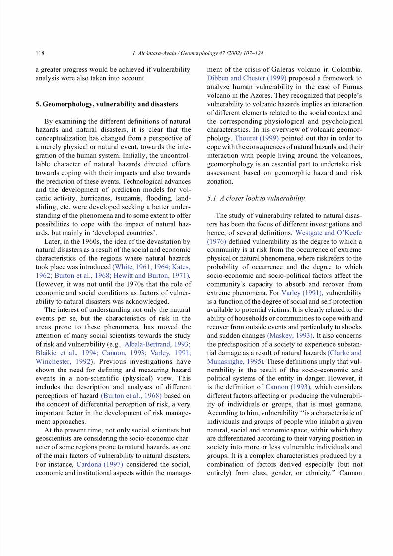
8102019 Articulo - Geomorphology Natural Hazards Vulnerability and Prevention of Natural Disasters in Developing Countrihellip
httpslidepdfcomreaderfullarticulo-geomorphology-natural-hazards-vulnerability-and-prevention-of 1318
divided vulnerability into three parts (1) Livelihood
resilience the degree of resilience of the particular
livelihood system of an individual or group and their
capacity for resisting the impact of hazard (2) Healthincluding both the robustness of individuals and the
operation of various social measures (3) Preparedness
determined by the protection available for a given
hazard something that depends on people acting on
their own behalf and social factors
These three aspects cover a great proportion of the
different kinds of vulnerabilities Nevertheless each
aspect has different components and the combinations
of them can be so numerous that it is necessary to
specify the particular types of vulnerability of each
threatened entity The latter will provide an adequate
understanding of the total vulnerability to natural
disasters so that prevention can be effectively accom-
plished This insight strengthens the contribution of
Aysan (1993) who recognizes different kinds of
vulnerability as follows
Lack of access to resources (materialseconomic
vulnerability) Disintegration of social patterns (social vulnerabil-
ity) Lack of strong national and local institutional
structures (organizational vulnerability) Lack of access to information and knowledge
(educational vulnerability) Lack of public awareness (attitudinal and motiva-
tional vulnerability) Limited access to political power and representa-
tion (political vulnerability) Certain beliefs and customs (cultural vulner-
ability) Weak buildings of weak individuals (physical
vulnerability)
There are indeed many other kinds of vulnerability
However all of them can be inserted within four main
types of vulnerability social economic political and
cultural This classification indicates that each social
entity has different types of vulnerability and it is not
only the result of the human actions decisions and
choices it is the result of the interaction of the natural
economic social cultural and political contexts where
people live Vulnerability cannot be treated as a
homogeneous and general term its dynamism is given
by each society and it is both a universal and
particular concept There is certainly a differential
character of vulnerability Vulnerability is given by
t he coupling between the natural and human systems(Fig 9) In this sense vulnerability can be divided
into natural vulnerability and human vulnerability
Natural vulnerability depends on the threatening nat-
ural hazard (very much related to geographical loca-
tion) thus there is volcanic vulnerability flooding
vulnerability landsliding vulnerability tsunamis vul-
nerability hurricane vulnerability and so on On con-
trast human vulnerability is based on the social
economical political and cultural systems
Hence vulnerability can be defined as the propen-
sity of an endangered element due to any kind of
natural hazard to suffer different degrees of loss or
amount of damage depending on its particular social
economic cultural and political weaknesses Total
vulnerability is a function of the individual types of
vulnerability present in a given area Such vulnerabil-
ity determines the magnitude of the disaster the level
of resilience and the recovery process
52 A step forward into the prevention of natural
disasters applied geomorphology
The reduction of natural vulnerability could beobtained from an equal access to scientific informa-
tional resources and methodologies for the understand-
ing and prediction of natural hazards (eg state-of-art
predicting models) and to international training pro-
grams Natural hazards cannot be prevented but the
understanding of the process and scientific method-
ologies to predict patterns of behavior of such pro-
cesses can be powerful tools to help reduce natural
vulnerability
Geomorphological research can provide theoretical
and applied approaches to the prevention of naturaldisasters in terms of origin and dynamism of the
physical processes Furthermore geomorphologists
could also offer important contributions based on the
understanding of the interaction between natural haz-
ards (natural vulnerability) and the societies (human
vulnerability) Consequently they should be involved
to a greater extent in such tasks as is the case of the
contributions of D Alexander M Panizza and HT
Verstappenmdashto mention the most familiar examplesmdash
who not only have shed light on understanding geo-
I Alca ntara-Ayala Geomorphology 47 (2002) 107ndash124 119
8102019 Articulo - Geomorphology Natural Hazards Vulnerability and Prevention of Natural Disasters in Developing Countrihellip
httpslidepdfcomreaderfullarticulo-geomorphology-natural-hazards-vulnerability-and-prevention-of 1418
morphological processes but also on the strong link
between the processes and society
Geomorphology can be considered a strategic
discipline in the reduction of both human and natural
vulnerabilities By contributing to the understanding
of endogenetic and exogenetic processes method-
ologies to predict patterns of occurrence of hazardous
events can be developed and applied Geomorpholo-
gists assist in the reduction of natural vulnerability inthree different ways first by enriching the theoretical
knowledge of geomorphology which is the base of
the application of our discipline second by develop-
ing prediction models for different processes such as
landsliding flooding volcanism among others and
finally through diversified approaches of applied
geomorphology for the prevention of natural disas-
ters Indeed geomorphology is a powerful field that
must play a role in the interdisciplinary efforts to
develop adequate strategies for prevention and miti-
gation of natural disasters Nonetheless contributions
of geomorphology would be even more significant if
research applications were directed towards the
understanding and coupling of human and natural
vulnerabilities Reduction of natural disasters is a
complex task by nature however it is now clear
that a combination not only of social and scientific
knowledge but also of attitudes towards the elabo-
ration of adequate strategies based on vulnerabilityanalysis of the particular social entities is urgently
required
6 Conclusions
Natural hazards are threatening events capable of
producing damage to the physical and social space in
which they take place not only at the moment of their
occurrence but in the long-term due to their associ-
Fig 9 The ingredients of natural disasters
I Alca ntara-Ayala Geomorphology 47 (2002) 107ndash124120
8102019 Articulo - Geomorphology Natural Hazards Vulnerability and Prevention of Natural Disasters in Developing Countrihellip
httpslidepdfcomreaderfullarticulo-geomorphology-natural-hazards-vulnerability-and-prevention-of 1518
ated consequences When these consequences have an
impact on society andor infrastructure they become
natural disasters These can be considered as sudden
but expected (we all know that they occur) naturalevents which impact the human and natural systems
The degree of their impact in space and time is a
function of the exposure to and the magnitude of the
natural phenomena (natural vulnerability) and the
human vulnerability of the threatened entity
Natural disasters occur all over the world how-
ever their impact in developing countries is greater
due to the geographical location in zones highly
susceptible to natural hazards (natural vulnerability)
and also due to the different types of economic social
political and cultural vulnerabilities that exist These
vulnerabilities are indeed the result of their historical
development and their social political economic and
cultural contexts The rich get richer the poor poorer
and the access to opportunities within the social entity
are unequal and indirectly proportional to the occur-
rence of natural disasters (the less opportunities the
more vulnerability the more affected by natural dis-
asters)
The International Decade for Natural Disaster
Reduction (IDNDR) has achieved several goals such
as the organization of international groups to provide
advice on the prevention of natural disasters onregional and national bases Events such as Hurricane
Mitch in Central America (October 1998) the earth-
quake in Turkey (August 1999) and their devastating
consequences demonstrated that natural disasters
occur in places where the geographical coordinates
of natural and human vulnerabilities converge An
effort must be made to promote the elaboration of
vulnerability analysis within a risk assessment and
management framework where not only geomor-
phology but also geomorphologists play a key role
for the prevention of natural disasters The latter needs indeed to be more rapidly implemented in
developing countries
Acknowledgements
Natural disasters registered data were kindly
provided by the ODFACRED International Disaster
Database Center for Research into the Epidemiology of
Disasters (CRED) Catholic University of Louvain
Belgium (httpwwwmduclacbecred) and the Of-
fice of US Foreign Disaster Assistance (httpwww
usaidgovhum _ responseofda ) Thanks are also due to
BE Montz CL Rosenfeld and PLK Knuepfer for critical reviewing of this paper
References
Albala-Bertrand JM 1993 Political Economy of Large Natural
Disasters With Special Reference to Developing Countries Ox-
ford Univ Press London 259 pp
Alexander D 1993 Natural Disasters UCL Press and Chapman amp
Hall New York 632 pp
Al-Homoud AS Tubeileh T 1997 An inventory for evaluating
hazard and risk assessment of cut slopes in weak rocks along
highways Bull Int Assoc Eng Geol 55 39ndash51Anderson JL Decker RW 1992 Volcano risk mitigation
through training In McCall GJH Laming DJC Scott
SC (Eds) Geohazards Natural and Man-Made Chapman amp
Hall London pp 7 ndash 12
Anderson MG Collison AJC Hartshorne J Lloyd DM
Park A 1996 Developments in slope hydrology-stability mod-
eling for tropical slopes In Anderson MG Brooks SM
(Eds) Advances in Hillslope Processes vol 2 Wiley Chiches-
ter pp 799ndash821
Aysan YF 1993 Vulnerability assessment In Merriman PA
Browitt CWA (Eds) Natural Disasters Protecting Vulnerable
Communities Thomas Telford London pp 1 ndash 14
Baker VR 1994 Geomorphological understanding of floods Geo-
morphology 10 139ndash156
Barkun N 1974 Disaster and the Millenium Yale Univ Press
New Haven
Bates PD De Roo APJ 2000 A simple raster-based model for
flood inundation simulation J Hydrol 236 54ndash77
Blaikie P Cannon T Davis I Wisner B 1994 At Risk Natural
Hazards Peoplersquos Vulnerability and Disasters Routledge Lon-
don 284 pp
Brooks SM Collison AJC 1996 The significance of soil pro-
file differentiation to hydrological response and slope instability
a modeling approach In Anderson MG Brooks SM (Eds)
Advances in Hillslope Processes vol 2 Wiley Chichester pp
471ndash486
Brunsden D 1993 Mass movement the research frontier and bey ond a geomor phological approa ch Geom orp hology 7
85ndash128
Brunsden D 1999 Some geomorphological considerations for the
future development of landslide models Geomorphology 30
13ndash24
Burton I Kates RW 1964 The perception of natural hazards in
resource management Nat Resour J 3 412ndash441
Burton I Kates RW White GF 1968 The Human Ecology of
Extreme Geophysical Events Department of Geography Natu-
ral Hazards Research Working Paper No 1 University of Tor-
onto
Cannon T 1993 A hazard need not a disaster make vulnerability
I Alca ntara-Ayala Geomorphology 47 (2002) 107ndash124 121
8102019 Articulo - Geomorphology Natural Hazards Vulnerability and Prevention of Natural Disasters in Developing Countrihellip
httpslidepdfcomreaderfullarticulo-geomorphology-natural-hazards-vulnerability-and-prevention-of 1618
and the causes of lsquonaturalrsquo disasters In Merriman PA Bro-
witt CWA (Eds) Natural Disasters Protecting Vulnerable
Communities Thomas Telford London pp 92ndash 105
Canuti P Focardi P Garzonia CA Rodolfi G Vannocci P
1987 Slope stability mapping in Tuscany Italy In Gardiner V(Ed) International Geomorphology 1986 Part I Wiley London
pp 231 ndash 240
Cardona OD 1997 Management of the volcanic crises of Galeras
volcano social economic and institutional aspects J Volcanol
Geother Res 77 313ndash324
Carrara A Cardinali M Detti R Guzzetti F Pasqui V Reich-
enbach P 1990 Geographical information systems and multi-
variate models in landslide hazard evaluation In Cancelli A
(Ed) Alps 90 Int Conf and Field Workshop on Landslides
Milano pp 17ndash 28
CEPAL 1999 Central America Assessment of the Damage Caused
by Hurricane Mitch 1998 Implications for Economic and So-
cial Development and for the Environment 41 pp At http
wwwcepalorgmx
Chacon J Irigaray C El Hamdouni R Fernandez T 1996
From the inventory to the risk analisis improvements to a large
scale GIS method In Chacon J Irigaray C Fernandez T
(Eds) Landslides Balkema Rotterdam pp 335ndash342
Chandler JH Brunsden D 1995 Steady state behaviour of the
Black Ven mudslide the application of archival analytical pho-
togrammetry to studies of landform change Earth Surf Pro-
cesses Landf 20 255ndash275
Chandler JH Cooper MAR 1989 The extraction of positional
data from historical photographs and their application in geo-
morphology Photogramm Rec 13 (73) 69 ndash 78
Chandler JH Moore R 1989 Analytical photogrammetry a
method for monitoring slope instability Q J Eng Geol 2297ndash110
Chang TJ Hsu MH Teng WH Huang CJ 2000 A GIS-
assisted distributed watershed model for simulating flooding and
inundation J Am Wat Resour Assoc 36 (5) 975 ndash 988
Chowdhury MR 2000 An assessment of flood forecasting in
Bangladesh the experience of the 1998 flood Nat Hazards
22 (2) 139ndash163
Clarke C Munasinghe M 1995 Economic aspects of disasters
and sustainable development an introduction In Munasinghe
M Clarke C (Eds) Disaster Prevention for Sustainable De-
velopment Economy and Policy Issues IDNDR and the World
Bank Washington pp 1ndash10
Collison AJC Anderson MG 1996 Using a combined slope
hydrology-slope stability model to identify suitable conditionsfor landslide prevention by vegetation in the humid tropics
Earth Surf Processes Landf 21 (8) 737ndash747
Collison AJC Anderson MG Lloyd DM 1995 The impact
of vegetation on slope stability in a humid tropical environment
a modeling approach Inst Civil Eng Water Marit Energy 112
168ndash175
Corominas J Moya J 1996 Historical landslides in the eastern
Pyrenees and their relation to rainy events In Chacon J Iri-
garay C Fernandez T (Eds) Landslides Balkema Rotter-
dam pp 125ndash132
Dibben C Chester DK 1999 Human vulnerability in volcanic
environments the case of Furnas Sao Miguel Azores J Vol-
canol Geother Res 92 (1ndash2) 133ndash150
Dikau R Jaeger S 1993 The role of geomorphology in regional
landslide hazard assessment using GIS technologies In Reich-
enbach P Guzzetti F Carrara A (Eds) Workshop on Geo-graphic Information Systems in Assessing Natural Hazards
Univ Foreigners Perugia Italy pp 54 ndash 55
Dikau R Cavallin A Jaeger S 1992 Database and GIS for
landslide research in Europe In Casale R Fantechi R Flag-
eollet JC (Eds) Temporal Occurrence and Forecasting of
Landslides in the European Community Final Report vol 1
pp 97 ndash 116
Domınguez-Cuesta MJ Jimınez-Sanchez M Rodrıguez-Garcıa
A 1999 Press archives as temporal records of landslides in the
north of Spain relationships between rainfall and instability
slope events Geomorphology 30 125ndash132
Dowdeswell JA Lamb HF Lewin J 1988 Failure and flow on
a 35 degrees slope causes and three-dimensional observations
Earth Surf Processes Landf 13 737ndash746
Elsinga RJ Verstappen HT 1988 SPOT for earthquake hazard
zoning in southern Italy SPOT 1 Image utilization assessment
results Techniques Spatiales 1 Centre National drsquoEtudes Spa-
tiales Toulouse France pp 199ndash207
EM-DAT The OFDACRED International Disaster Database At
httpwwwcredbeemdat Universite Catholique de Louvain
Brussels Belgium
Enzel Y Wells SG 1997 Extracting Holocene paleohydrology
and paleoclimatology information from modern extreme flood
events an example from Southern California Geomorphology
19 203ndash226
Enzel Y Ely LL House PK Baker VR Webb RH 1993
Paleoflood evidence for a natural upper bound to flood magni-tudes in the Colorado River Water Resour Res 29 (7) 2287ndash
2297
Erdik M Biro YA Onur T Sesetyan K Birgoren G 1999
Assessment of earthquake hazard in Turkey and neighboring
regions Ann Geofis 42 1125ndash1138
Fritz CE 1961 Disasters In Merton RK Nisbet RA (Eds)
Contemporary Social Problems Harcourt New York pp 651ndash
694
Galadini F Galli P 2000 Active tectonics in the central Apen-
nines (Italy)mdashinput data for seismic hazard assessment Nat
Hazards 22 (3) 225ndash270
Gares PA Sherman DJ Nordstrom KF 1994 Geomorphology
and natural hazards Geomorphology 10 1ndash18
Gili JA Corominas J Rius J 2000 Using global positioningsystem techniques in landslide monitoring Eng Geol 55 (3)
167ndash192
Gomez-Fernandez F 2000 Contribution of geographical informa-
tion systems to the management of volcanic crises Nat Hazards
21 (2ndash 3) 347ndash 360
Guzzetti F Cardinali M Reichenbach P 1994 The AVI project
a bibliographical and archive inventory of landslides and floods
in Italy Environ Manage 18 (4) 623ndash633
Hansen A 1984 Landslide hazard analysis In Brunsden D
Prior DB (Eds) Slope Instability Wiley Chichester pp
523ndash602
I Alcantara-Ayala Geomorphology 47 (2002) 107ndash124122
8102019 Articulo - Geomorphology Natural Hazards Vulnerability and Prevention of Natural Disasters in Developing Countrihellip
httpslidepdfcomreaderfullarticulo-geomorphology-natural-hazards-vulnerability-and-prevention-of 1718
Hewitt K Burton I 1971 The Hazardousness of a Place A
Regional Ecology of Damaging Events Research Paper No 6
Department of Geography University of Toronto
Hutchinson JN 1992 Landslide Hazard Assessment Proc 6th
Int Symp on Landslides Christchurch New Zealand vol 3 pp 3 ndash 35
Ibsen ML Brunsden D 1996 The nature use and problems of
historical archives for the temporal occurrence of landslides
with specific reference to the south coast of Britain Ventnor
Isle of Wight Geomorphology 15 241ndash258
IDNDR 1992 Glossary Internationally Agreed Glossary of Basic
Terms Related to Disaster Management DHA-Geneva 83 pp
Islam MDM Sado K 2000 Development of flood hazard maps
of Bangladesh using NOAA-AVHRR images with GIS Hydrol
Sci J 45 337ndash355
Jenkins A Ashworth PJ Ferguson RI Grieve IC Rowling
P Stott TA 1988 Slope failures in the Ochil Hills Scotland
November 1984 Earth Surf Processes Landf 13 69 ndash 76
Kale VS Ely LL Enzel Y Baker VR 1994 Geomorphic and
hydrologic aspects of monsoon floods on the Narmada and Tapi
Rivers in central India Geomorphology 10 157ndash168
Kale VS Hire P Baker VR 1997 Flood hydrology and geo-
morphology of monsoon-dominated rivers the Indian Peninsu-
la Water Int 22 259ndash265
Kates RW 1962 Hazard and Choice Perception in Flood Plain
Management Research Paper No 78 Department of Geogra-
phy University of Chicago
Leroi E 1997 Landslide risk mapping problems limitations and
developments In Cruden DM Fell R (Eds) Landslide Risk
Assessment Balkema Rotterdam pp 239 ndash 250
Mantovani F Soeters R Van Westen CJ 1996 Remote sensing
techniques for landslide studies and hazard zonation in EuropeGeomorphology 15 213ndash225
Maskey A 1993 Vulnerability accumulation in peripheral regions
in Latin America the challenge for disaster prevention and
management In Merriman PA Browitt CWA (Eds) Nat-
ural Disasters Protecting Vulnerable Communities Thomas
Telford London pp 461ndash472
Merzi N Aktas MT 2000 Geographic information systems
(GIS) for the determination of inundation maps of Lake Mogan
Turkey Water Int 25 (3) 474ndash480
Montgomery DR Dietrich WE 1994 A physically based model
for the topographic control on shallow landsliding Water Re-
sour Res 30 (4) 1153ndash1171
Okuda S 1970 On the relation between physical geomorphology
and the science of natural disasters Bull Disaster Prev ResInst 19 (25) Part 5 Kyoto Japan
Ordaz M Reyes C 1999 Earthquake hazard in Mexico City
observations versus computations Bull Seismol Soc Am 89
(5) 1379ndash 1383
Panizza M 1981 Geomorphology and earthquake hazard in envi-
ronmental planning In Palmentola G Acquafredda P (Eds)
Proceedings of the International Conference on Seismic Zones
in the Mediterranean Area Basilicata Italy pp 203ndash207
Panizza M 1991 Geomorphology and seismic risk Earth-Sci
Rev 31 (1) 11ndash20
Pareschi MT Cavarra L Favalli M Giannini F Meriggi A
2000 GIS and volcanic risk management Nat Hazards 21 (2ndash
3) 361ndash379
Petley DN 1998 Geomorphological mapping for hazard assess-
ment in a neotectonic terrain Geogr J 164 (7) 183ndash201
Proske H 1996 GIS supported analysis of effects of joint systemson shallow landslides in a tectonically complex crystalline
catchment area In Chacon J Irigaray C Fernandez T
(Eds) Landslides Balkema Rotterdam pp 173ndash180
Rosenfeld CL 1994 The geomorphological dimensions of natural
disasters Geomorphology 10 27ndash36
Scheidegger AE 1994 Hazards singularities in geomorphic sys-
tems Geomorphology 10 19ndash25
Siegel H Gerth M 2000 Satellite-based studies of the 1997 Oder
flood event in the southern Baltic Sea Remote Sens Environ
73 (2) 207ndash217
Singhroy V Mattar KE Gray AL 1998 Landslide character-
isation in Canada using interferometric SAR and combined SAR
and TM images Adv Space Res 21 (3) 465ndash476
Slaymaker O 1996 Introduction In Slaymaker O (Ed) Geo-
morphic Hazards Wiley Chichester pp 1ndash7
Sousa J Voight B 1992 Computational flow modeling for long-
runout landslide hazard assessment with an example from Cla-
piere landslide France Bull Assoc Eng Geol 29 (2) 131 ndash
150
Summerfield MA 1991 Global Geomorphology An Introduction
to the Study of Landforms Wiley New York 537 pp
Terlien MTJ 1996 The prediction of rainfall-triggered soil slips
in Manizales (Colombia) In Chacon J Irigaray C Fernan-
dez T (Eds) Landslides Balkema Rotterdam pp 197 ndash 205
Thornes JB Alcantara-Ayala I 1998 Modelling mass failure in a
Mediterranean mountain environment climatic geological
topographical and erosional controls Geomorphology 24 87ndash 100
Thouret JC 1999 Urban hazards and risks consequences of
earthquakes and volcanic eruptions an introduction GeoJournal
49 (2) 131ndash135
Tobin GA Montz BE 1997 Natural Hazards Explanation and
Integration The Guilford Press New York 388 pp
UNDRO 1982 Natural Disasters and Vulnerability Analysis Of-
fice of the United Nations Disaster Relief Coordinator Geneva
Switzerland
Van Asch TWJ Buma JT 1997 Modelling groundwater fluc-
tuations and the frequency of movement of a landslide in the
Terres Noires region of Barcelonnette (France) Earth Surf Pro-
cesses Landf 22 131ndash141
Varley A 1991 Disasters vulnerability and response Disasters 15(3) 285ndash287
Verstappen HT 1988 Geomorphological surveys and natural haz-
ard zoning with special reference to volcanic hazards in central
Java Z Geomorphol Supplbd 68 81ndash101
Verstappen HT 1989 Geomorphology natural disasters and glob-
al change Symposium on Aerospace Survey and Natural Dis-
asters ITC J (3ndash4) 159ndash164
Verstappen HT 1992 Volcanic hazards in Colombia and Indone-
sia lahars and related phenomena In McCall GJH Laming
DDC Scott SC (Eds) Geohazards Natural and Man-Made
Chapman amp Hall London pp 33ndash42
I Alcantara-Ayala Geomorphology 47 (2002) 107ndash124 123
8102019 Articulo - Geomorphology Natural Hazards Vulnerability and Prevention of Natural Disasters in Developing Countrihellip
httpslidepdfcomreaderfullarticulo-geomorphology-natural-hazards-vulnerability-and-prevention-of 1818
Westgate KN OrsquoKeefe P 1976 Some Definitions of Disaster
Disaster Research Unit Occasional Paper No 4 Department of
Geography University of Bradford
White GF (Ed) 1961 Papers on Flood Problems Research Pa-
pers No 70 Department of Geography University of ChicagoWhite GF 1964 Choice of Adjustments to Floods Research Pa-
per No 93 Department of Geography University of Chicago
White GF 1973 Natural hazards research In Chorley RJ (Ed)
Directions in Geography Methuen London pp 193 ndash 216
Winchester P 1992 Power Choice and Vulnerability A Case
Study in Disaster Management in South India James amp James
London 225 pp
Wolman MG Miller JP 1960 Magnitude and frequency of
forces in geomorphic processes J Geol 68 (1) 54ndash74
Yin KL 1994 A computer-assisted mapping of landslide hazardevaluation 7th International IAEG Congress Balkema Rotter-
dam pp 4495ndash 4499
Zhou CH Luo JC Yang CJ Li BL Wang SL 2000 Flood
monitoring using multi-temporal AVHRR and RADARSAT im-
agery Photogramm Eng Remote Sensing 66 (5) 633ndash638
I Alca ntara-Ayala Geomorphology 47 (2002) 107ndash124124
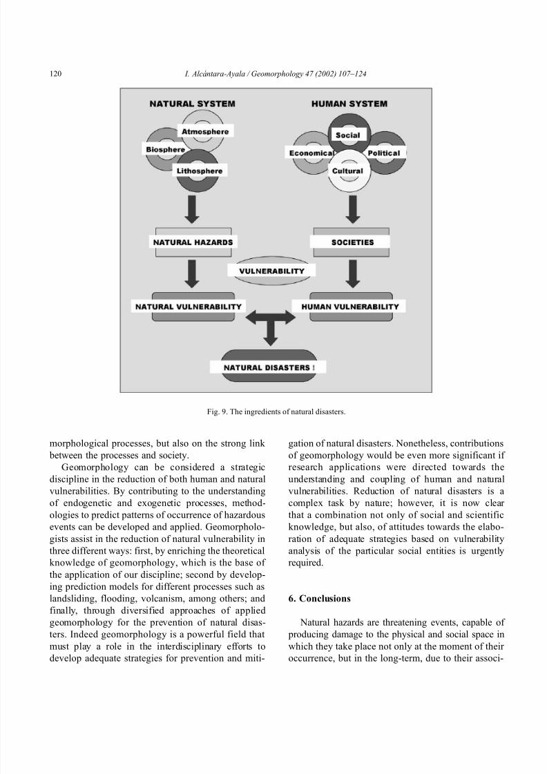
8102019 Articulo - Geomorphology Natural Hazards Vulnerability and Prevention of Natural Disasters in Developing Countrihellip
httpslidepdfcomreaderfullarticulo-geomorphology-natural-hazards-vulnerability-and-prevention-of 1418
morphological processes but also on the strong link
between the processes and society
Geomorphology can be considered a strategic
discipline in the reduction of both human and natural
vulnerabilities By contributing to the understanding
of endogenetic and exogenetic processes method-
ologies to predict patterns of occurrence of hazardous
events can be developed and applied Geomorpholo-
gists assist in the reduction of natural vulnerability inthree different ways first by enriching the theoretical
knowledge of geomorphology which is the base of
the application of our discipline second by develop-
ing prediction models for different processes such as
landsliding flooding volcanism among others and
finally through diversified approaches of applied
geomorphology for the prevention of natural disas-
ters Indeed geomorphology is a powerful field that
must play a role in the interdisciplinary efforts to
develop adequate strategies for prevention and miti-
gation of natural disasters Nonetheless contributions
of geomorphology would be even more significant if
research applications were directed towards the
understanding and coupling of human and natural
vulnerabilities Reduction of natural disasters is a
complex task by nature however it is now clear
that a combination not only of social and scientific
knowledge but also of attitudes towards the elabo-
ration of adequate strategies based on vulnerabilityanalysis of the particular social entities is urgently
required
6 Conclusions
Natural hazards are threatening events capable of
producing damage to the physical and social space in
which they take place not only at the moment of their
occurrence but in the long-term due to their associ-
Fig 9 The ingredients of natural disasters
I Alca ntara-Ayala Geomorphology 47 (2002) 107ndash124120
8102019 Articulo - Geomorphology Natural Hazards Vulnerability and Prevention of Natural Disasters in Developing Countrihellip
httpslidepdfcomreaderfullarticulo-geomorphology-natural-hazards-vulnerability-and-prevention-of 1518
ated consequences When these consequences have an
impact on society andor infrastructure they become
natural disasters These can be considered as sudden
but expected (we all know that they occur) naturalevents which impact the human and natural systems
The degree of their impact in space and time is a
function of the exposure to and the magnitude of the
natural phenomena (natural vulnerability) and the
human vulnerability of the threatened entity
Natural disasters occur all over the world how-
ever their impact in developing countries is greater
due to the geographical location in zones highly
susceptible to natural hazards (natural vulnerability)
and also due to the different types of economic social
political and cultural vulnerabilities that exist These
vulnerabilities are indeed the result of their historical
development and their social political economic and
cultural contexts The rich get richer the poor poorer
and the access to opportunities within the social entity
are unequal and indirectly proportional to the occur-
rence of natural disasters (the less opportunities the
more vulnerability the more affected by natural dis-
asters)
The International Decade for Natural Disaster
Reduction (IDNDR) has achieved several goals such
as the organization of international groups to provide
advice on the prevention of natural disasters onregional and national bases Events such as Hurricane
Mitch in Central America (October 1998) the earth-
quake in Turkey (August 1999) and their devastating
consequences demonstrated that natural disasters
occur in places where the geographical coordinates
of natural and human vulnerabilities converge An
effort must be made to promote the elaboration of
vulnerability analysis within a risk assessment and
management framework where not only geomor-
phology but also geomorphologists play a key role
for the prevention of natural disasters The latter needs indeed to be more rapidly implemented in
developing countries
Acknowledgements
Natural disasters registered data were kindly
provided by the ODFACRED International Disaster
Database Center for Research into the Epidemiology of
Disasters (CRED) Catholic University of Louvain
Belgium (httpwwwmduclacbecred) and the Of-
fice of US Foreign Disaster Assistance (httpwww
usaidgovhum _ responseofda ) Thanks are also due to
BE Montz CL Rosenfeld and PLK Knuepfer for critical reviewing of this paper
References
Albala-Bertrand JM 1993 Political Economy of Large Natural
Disasters With Special Reference to Developing Countries Ox-
ford Univ Press London 259 pp
Alexander D 1993 Natural Disasters UCL Press and Chapman amp
Hall New York 632 pp
Al-Homoud AS Tubeileh T 1997 An inventory for evaluating
hazard and risk assessment of cut slopes in weak rocks along
highways Bull Int Assoc Eng Geol 55 39ndash51Anderson JL Decker RW 1992 Volcano risk mitigation
through training In McCall GJH Laming DJC Scott
SC (Eds) Geohazards Natural and Man-Made Chapman amp
Hall London pp 7 ndash 12
Anderson MG Collison AJC Hartshorne J Lloyd DM
Park A 1996 Developments in slope hydrology-stability mod-
eling for tropical slopes In Anderson MG Brooks SM
(Eds) Advances in Hillslope Processes vol 2 Wiley Chiches-
ter pp 799ndash821
Aysan YF 1993 Vulnerability assessment In Merriman PA
Browitt CWA (Eds) Natural Disasters Protecting Vulnerable
Communities Thomas Telford London pp 1 ndash 14
Baker VR 1994 Geomorphological understanding of floods Geo-
morphology 10 139ndash156
Barkun N 1974 Disaster and the Millenium Yale Univ Press
New Haven
Bates PD De Roo APJ 2000 A simple raster-based model for
flood inundation simulation J Hydrol 236 54ndash77
Blaikie P Cannon T Davis I Wisner B 1994 At Risk Natural
Hazards Peoplersquos Vulnerability and Disasters Routledge Lon-
don 284 pp
Brooks SM Collison AJC 1996 The significance of soil pro-
file differentiation to hydrological response and slope instability
a modeling approach In Anderson MG Brooks SM (Eds)
Advances in Hillslope Processes vol 2 Wiley Chichester pp
471ndash486
Brunsden D 1993 Mass movement the research frontier and bey ond a geomor phological approa ch Geom orp hology 7
85ndash128
Brunsden D 1999 Some geomorphological considerations for the
future development of landslide models Geomorphology 30
13ndash24
Burton I Kates RW 1964 The perception of natural hazards in
resource management Nat Resour J 3 412ndash441
Burton I Kates RW White GF 1968 The Human Ecology of
Extreme Geophysical Events Department of Geography Natu-
ral Hazards Research Working Paper No 1 University of Tor-
onto
Cannon T 1993 A hazard need not a disaster make vulnerability
I Alca ntara-Ayala Geomorphology 47 (2002) 107ndash124 121
8102019 Articulo - Geomorphology Natural Hazards Vulnerability and Prevention of Natural Disasters in Developing Countrihellip
httpslidepdfcomreaderfullarticulo-geomorphology-natural-hazards-vulnerability-and-prevention-of 1618
and the causes of lsquonaturalrsquo disasters In Merriman PA Bro-
witt CWA (Eds) Natural Disasters Protecting Vulnerable
Communities Thomas Telford London pp 92ndash 105
Canuti P Focardi P Garzonia CA Rodolfi G Vannocci P
1987 Slope stability mapping in Tuscany Italy In Gardiner V(Ed) International Geomorphology 1986 Part I Wiley London
pp 231 ndash 240
Cardona OD 1997 Management of the volcanic crises of Galeras
volcano social economic and institutional aspects J Volcanol
Geother Res 77 313ndash324
Carrara A Cardinali M Detti R Guzzetti F Pasqui V Reich-
enbach P 1990 Geographical information systems and multi-
variate models in landslide hazard evaluation In Cancelli A
(Ed) Alps 90 Int Conf and Field Workshop on Landslides
Milano pp 17ndash 28
CEPAL 1999 Central America Assessment of the Damage Caused
by Hurricane Mitch 1998 Implications for Economic and So-
cial Development and for the Environment 41 pp At http
wwwcepalorgmx
Chacon J Irigaray C El Hamdouni R Fernandez T 1996
From the inventory to the risk analisis improvements to a large
scale GIS method In Chacon J Irigaray C Fernandez T
(Eds) Landslides Balkema Rotterdam pp 335ndash342
Chandler JH Brunsden D 1995 Steady state behaviour of the
Black Ven mudslide the application of archival analytical pho-
togrammetry to studies of landform change Earth Surf Pro-
cesses Landf 20 255ndash275
Chandler JH Cooper MAR 1989 The extraction of positional
data from historical photographs and their application in geo-
morphology Photogramm Rec 13 (73) 69 ndash 78
Chandler JH Moore R 1989 Analytical photogrammetry a
method for monitoring slope instability Q J Eng Geol 2297ndash110
Chang TJ Hsu MH Teng WH Huang CJ 2000 A GIS-
assisted distributed watershed model for simulating flooding and
inundation J Am Wat Resour Assoc 36 (5) 975 ndash 988
Chowdhury MR 2000 An assessment of flood forecasting in
Bangladesh the experience of the 1998 flood Nat Hazards
22 (2) 139ndash163
Clarke C Munasinghe M 1995 Economic aspects of disasters
and sustainable development an introduction In Munasinghe
M Clarke C (Eds) Disaster Prevention for Sustainable De-
velopment Economy and Policy Issues IDNDR and the World
Bank Washington pp 1ndash10
Collison AJC Anderson MG 1996 Using a combined slope
hydrology-slope stability model to identify suitable conditionsfor landslide prevention by vegetation in the humid tropics
Earth Surf Processes Landf 21 (8) 737ndash747
Collison AJC Anderson MG Lloyd DM 1995 The impact
of vegetation on slope stability in a humid tropical environment
a modeling approach Inst Civil Eng Water Marit Energy 112
168ndash175
Corominas J Moya J 1996 Historical landslides in the eastern
Pyrenees and their relation to rainy events In Chacon J Iri-
garay C Fernandez T (Eds) Landslides Balkema Rotter-
dam pp 125ndash132
Dibben C Chester DK 1999 Human vulnerability in volcanic
environments the case of Furnas Sao Miguel Azores J Vol-
canol Geother Res 92 (1ndash2) 133ndash150
Dikau R Jaeger S 1993 The role of geomorphology in regional
landslide hazard assessment using GIS technologies In Reich-
enbach P Guzzetti F Carrara A (Eds) Workshop on Geo-graphic Information Systems in Assessing Natural Hazards
Univ Foreigners Perugia Italy pp 54 ndash 55
Dikau R Cavallin A Jaeger S 1992 Database and GIS for
landslide research in Europe In Casale R Fantechi R Flag-
eollet JC (Eds) Temporal Occurrence and Forecasting of
Landslides in the European Community Final Report vol 1
pp 97 ndash 116
Domınguez-Cuesta MJ Jimınez-Sanchez M Rodrıguez-Garcıa
A 1999 Press archives as temporal records of landslides in the
north of Spain relationships between rainfall and instability
slope events Geomorphology 30 125ndash132
Dowdeswell JA Lamb HF Lewin J 1988 Failure and flow on
a 35 degrees slope causes and three-dimensional observations
Earth Surf Processes Landf 13 737ndash746
Elsinga RJ Verstappen HT 1988 SPOT for earthquake hazard
zoning in southern Italy SPOT 1 Image utilization assessment
results Techniques Spatiales 1 Centre National drsquoEtudes Spa-
tiales Toulouse France pp 199ndash207
EM-DAT The OFDACRED International Disaster Database At
httpwwwcredbeemdat Universite Catholique de Louvain
Brussels Belgium
Enzel Y Wells SG 1997 Extracting Holocene paleohydrology
and paleoclimatology information from modern extreme flood
events an example from Southern California Geomorphology
19 203ndash226
Enzel Y Ely LL House PK Baker VR Webb RH 1993
Paleoflood evidence for a natural upper bound to flood magni-tudes in the Colorado River Water Resour Res 29 (7) 2287ndash
2297
Erdik M Biro YA Onur T Sesetyan K Birgoren G 1999
Assessment of earthquake hazard in Turkey and neighboring
regions Ann Geofis 42 1125ndash1138
Fritz CE 1961 Disasters In Merton RK Nisbet RA (Eds)
Contemporary Social Problems Harcourt New York pp 651ndash
694
Galadini F Galli P 2000 Active tectonics in the central Apen-
nines (Italy)mdashinput data for seismic hazard assessment Nat
Hazards 22 (3) 225ndash270
Gares PA Sherman DJ Nordstrom KF 1994 Geomorphology
and natural hazards Geomorphology 10 1ndash18
Gili JA Corominas J Rius J 2000 Using global positioningsystem techniques in landslide monitoring Eng Geol 55 (3)
167ndash192
Gomez-Fernandez F 2000 Contribution of geographical informa-
tion systems to the management of volcanic crises Nat Hazards
21 (2ndash 3) 347ndash 360
Guzzetti F Cardinali M Reichenbach P 1994 The AVI project
a bibliographical and archive inventory of landslides and floods
in Italy Environ Manage 18 (4) 623ndash633
Hansen A 1984 Landslide hazard analysis In Brunsden D
Prior DB (Eds) Slope Instability Wiley Chichester pp
523ndash602
I Alcantara-Ayala Geomorphology 47 (2002) 107ndash124122
8102019 Articulo - Geomorphology Natural Hazards Vulnerability and Prevention of Natural Disasters in Developing Countrihellip
httpslidepdfcomreaderfullarticulo-geomorphology-natural-hazards-vulnerability-and-prevention-of 1718
Hewitt K Burton I 1971 The Hazardousness of a Place A
Regional Ecology of Damaging Events Research Paper No 6
Department of Geography University of Toronto
Hutchinson JN 1992 Landslide Hazard Assessment Proc 6th
Int Symp on Landslides Christchurch New Zealand vol 3 pp 3 ndash 35
Ibsen ML Brunsden D 1996 The nature use and problems of
historical archives for the temporal occurrence of landslides
with specific reference to the south coast of Britain Ventnor
Isle of Wight Geomorphology 15 241ndash258
IDNDR 1992 Glossary Internationally Agreed Glossary of Basic
Terms Related to Disaster Management DHA-Geneva 83 pp
Islam MDM Sado K 2000 Development of flood hazard maps
of Bangladesh using NOAA-AVHRR images with GIS Hydrol
Sci J 45 337ndash355
Jenkins A Ashworth PJ Ferguson RI Grieve IC Rowling
P Stott TA 1988 Slope failures in the Ochil Hills Scotland
November 1984 Earth Surf Processes Landf 13 69 ndash 76
Kale VS Ely LL Enzel Y Baker VR 1994 Geomorphic and
hydrologic aspects of monsoon floods on the Narmada and Tapi
Rivers in central India Geomorphology 10 157ndash168
Kale VS Hire P Baker VR 1997 Flood hydrology and geo-
morphology of monsoon-dominated rivers the Indian Peninsu-
la Water Int 22 259ndash265
Kates RW 1962 Hazard and Choice Perception in Flood Plain
Management Research Paper No 78 Department of Geogra-
phy University of Chicago
Leroi E 1997 Landslide risk mapping problems limitations and
developments In Cruden DM Fell R (Eds) Landslide Risk
Assessment Balkema Rotterdam pp 239 ndash 250
Mantovani F Soeters R Van Westen CJ 1996 Remote sensing
techniques for landslide studies and hazard zonation in EuropeGeomorphology 15 213ndash225
Maskey A 1993 Vulnerability accumulation in peripheral regions
in Latin America the challenge for disaster prevention and
management In Merriman PA Browitt CWA (Eds) Nat-
ural Disasters Protecting Vulnerable Communities Thomas
Telford London pp 461ndash472
Merzi N Aktas MT 2000 Geographic information systems
(GIS) for the determination of inundation maps of Lake Mogan
Turkey Water Int 25 (3) 474ndash480
Montgomery DR Dietrich WE 1994 A physically based model
for the topographic control on shallow landsliding Water Re-
sour Res 30 (4) 1153ndash1171
Okuda S 1970 On the relation between physical geomorphology
and the science of natural disasters Bull Disaster Prev ResInst 19 (25) Part 5 Kyoto Japan
Ordaz M Reyes C 1999 Earthquake hazard in Mexico City
observations versus computations Bull Seismol Soc Am 89
(5) 1379ndash 1383
Panizza M 1981 Geomorphology and earthquake hazard in envi-
ronmental planning In Palmentola G Acquafredda P (Eds)
Proceedings of the International Conference on Seismic Zones
in the Mediterranean Area Basilicata Italy pp 203ndash207
Panizza M 1991 Geomorphology and seismic risk Earth-Sci
Rev 31 (1) 11ndash20
Pareschi MT Cavarra L Favalli M Giannini F Meriggi A
2000 GIS and volcanic risk management Nat Hazards 21 (2ndash
3) 361ndash379
Petley DN 1998 Geomorphological mapping for hazard assess-
ment in a neotectonic terrain Geogr J 164 (7) 183ndash201
Proske H 1996 GIS supported analysis of effects of joint systemson shallow landslides in a tectonically complex crystalline
catchment area In Chacon J Irigaray C Fernandez T
(Eds) Landslides Balkema Rotterdam pp 173ndash180
Rosenfeld CL 1994 The geomorphological dimensions of natural
disasters Geomorphology 10 27ndash36
Scheidegger AE 1994 Hazards singularities in geomorphic sys-
tems Geomorphology 10 19ndash25
Siegel H Gerth M 2000 Satellite-based studies of the 1997 Oder
flood event in the southern Baltic Sea Remote Sens Environ
73 (2) 207ndash217
Singhroy V Mattar KE Gray AL 1998 Landslide character-
isation in Canada using interferometric SAR and combined SAR
and TM images Adv Space Res 21 (3) 465ndash476
Slaymaker O 1996 Introduction In Slaymaker O (Ed) Geo-
morphic Hazards Wiley Chichester pp 1ndash7
Sousa J Voight B 1992 Computational flow modeling for long-
runout landslide hazard assessment with an example from Cla-
piere landslide France Bull Assoc Eng Geol 29 (2) 131 ndash
150
Summerfield MA 1991 Global Geomorphology An Introduction
to the Study of Landforms Wiley New York 537 pp
Terlien MTJ 1996 The prediction of rainfall-triggered soil slips
in Manizales (Colombia) In Chacon J Irigaray C Fernan-
dez T (Eds) Landslides Balkema Rotterdam pp 197 ndash 205
Thornes JB Alcantara-Ayala I 1998 Modelling mass failure in a
Mediterranean mountain environment climatic geological
topographical and erosional controls Geomorphology 24 87ndash 100
Thouret JC 1999 Urban hazards and risks consequences of
earthquakes and volcanic eruptions an introduction GeoJournal
49 (2) 131ndash135
Tobin GA Montz BE 1997 Natural Hazards Explanation and
Integration The Guilford Press New York 388 pp
UNDRO 1982 Natural Disasters and Vulnerability Analysis Of-
fice of the United Nations Disaster Relief Coordinator Geneva
Switzerland
Van Asch TWJ Buma JT 1997 Modelling groundwater fluc-
tuations and the frequency of movement of a landslide in the
Terres Noires region of Barcelonnette (France) Earth Surf Pro-
cesses Landf 22 131ndash141
Varley A 1991 Disasters vulnerability and response Disasters 15(3) 285ndash287
Verstappen HT 1988 Geomorphological surveys and natural haz-
ard zoning with special reference to volcanic hazards in central
Java Z Geomorphol Supplbd 68 81ndash101
Verstappen HT 1989 Geomorphology natural disasters and glob-
al change Symposium on Aerospace Survey and Natural Dis-
asters ITC J (3ndash4) 159ndash164
Verstappen HT 1992 Volcanic hazards in Colombia and Indone-
sia lahars and related phenomena In McCall GJH Laming
DDC Scott SC (Eds) Geohazards Natural and Man-Made
Chapman amp Hall London pp 33ndash42
I Alcantara-Ayala Geomorphology 47 (2002) 107ndash124 123
8102019 Articulo - Geomorphology Natural Hazards Vulnerability and Prevention of Natural Disasters in Developing Countrihellip
httpslidepdfcomreaderfullarticulo-geomorphology-natural-hazards-vulnerability-and-prevention-of 1818
Westgate KN OrsquoKeefe P 1976 Some Definitions of Disaster
Disaster Research Unit Occasional Paper No 4 Department of
Geography University of Bradford
White GF (Ed) 1961 Papers on Flood Problems Research Pa-
pers No 70 Department of Geography University of ChicagoWhite GF 1964 Choice of Adjustments to Floods Research Pa-
per No 93 Department of Geography University of Chicago
White GF 1973 Natural hazards research In Chorley RJ (Ed)
Directions in Geography Methuen London pp 193 ndash 216
Winchester P 1992 Power Choice and Vulnerability A Case
Study in Disaster Management in South India James amp James
London 225 pp
Wolman MG Miller JP 1960 Magnitude and frequency of
forces in geomorphic processes J Geol 68 (1) 54ndash74
Yin KL 1994 A computer-assisted mapping of landslide hazardevaluation 7th International IAEG Congress Balkema Rotter-
dam pp 4495ndash 4499
Zhou CH Luo JC Yang CJ Li BL Wang SL 2000 Flood
monitoring using multi-temporal AVHRR and RADARSAT im-
agery Photogramm Eng Remote Sensing 66 (5) 633ndash638
I Alca ntara-Ayala Geomorphology 47 (2002) 107ndash124124
8102019 Articulo - Geomorphology Natural Hazards Vulnerability and Prevention of Natural Disasters in Developing Countrihellip
httpslidepdfcomreaderfullarticulo-geomorphology-natural-hazards-vulnerability-and-prevention-of 1718
Hewitt K Burton I 1971 The Hazardousness of a Place A
Regional Ecology of Damaging Events Research Paper No 6
Department of Geography University of Toronto
Hutchinson JN 1992 Landslide Hazard Assessment Proc 6th
Int Symp on Landslides Christchurch New Zealand vol 3 pp 3 ndash 35
Ibsen ML Brunsden D 1996 The nature use and problems of
historical archives for the temporal occurrence of landslides
with specific reference to the south coast of Britain Ventnor
Isle of Wight Geomorphology 15 241ndash258
IDNDR 1992 Glossary Internationally Agreed Glossary of Basic
Terms Related to Disaster Management DHA-Geneva 83 pp
Islam MDM Sado K 2000 Development of flood hazard maps
of Bangladesh using NOAA-AVHRR images with GIS Hydrol
Sci J 45 337ndash355
Jenkins A Ashworth PJ Ferguson RI Grieve IC Rowling
P Stott TA 1988 Slope failures in the Ochil Hills Scotland
November 1984 Earth Surf Processes Landf 13 69 ndash 76
Kale VS Ely LL Enzel Y Baker VR 1994 Geomorphic and
hydrologic aspects of monsoon floods on the Narmada and Tapi
Rivers in central India Geomorphology 10 157ndash168
Kale VS Hire P Baker VR 1997 Flood hydrology and geo-
morphology of monsoon-dominated rivers the Indian Peninsu-
la Water Int 22 259ndash265
Kates RW 1962 Hazard and Choice Perception in Flood Plain
Management Research Paper No 78 Department of Geogra-
phy University of Chicago
Leroi E 1997 Landslide risk mapping problems limitations and
developments In Cruden DM Fell R (Eds) Landslide Risk
Assessment Balkema Rotterdam pp 239 ndash 250
Mantovani F Soeters R Van Westen CJ 1996 Remote sensing
techniques for landslide studies and hazard zonation in EuropeGeomorphology 15 213ndash225
Maskey A 1993 Vulnerability accumulation in peripheral regions
in Latin America the challenge for disaster prevention and
management In Merriman PA Browitt CWA (Eds) Nat-
ural Disasters Protecting Vulnerable Communities Thomas
Telford London pp 461ndash472
Merzi N Aktas MT 2000 Geographic information systems
(GIS) for the determination of inundation maps of Lake Mogan
Turkey Water Int 25 (3) 474ndash480
Montgomery DR Dietrich WE 1994 A physically based model
for the topographic control on shallow landsliding Water Re-
sour Res 30 (4) 1153ndash1171
Okuda S 1970 On the relation between physical geomorphology
and the science of natural disasters Bull Disaster Prev ResInst 19 (25) Part 5 Kyoto Japan
Ordaz M Reyes C 1999 Earthquake hazard in Mexico City
observations versus computations Bull Seismol Soc Am 89
(5) 1379ndash 1383
Panizza M 1981 Geomorphology and earthquake hazard in envi-
ronmental planning In Palmentola G Acquafredda P (Eds)
Proceedings of the International Conference on Seismic Zones
in the Mediterranean Area Basilicata Italy pp 203ndash207
Panizza M 1991 Geomorphology and seismic risk Earth-Sci
Rev 31 (1) 11ndash20
Pareschi MT Cavarra L Favalli M Giannini F Meriggi A
2000 GIS and volcanic risk management Nat Hazards 21 (2ndash
3) 361ndash379
Petley DN 1998 Geomorphological mapping for hazard assess-
ment in a neotectonic terrain Geogr J 164 (7) 183ndash201
Proske H 1996 GIS supported analysis of effects of joint systemson shallow landslides in a tectonically complex crystalline
catchment area In Chacon J Irigaray C Fernandez T
(Eds) Landslides Balkema Rotterdam pp 173ndash180
Rosenfeld CL 1994 The geomorphological dimensions of natural
disasters Geomorphology 10 27ndash36
Scheidegger AE 1994 Hazards singularities in geomorphic sys-
tems Geomorphology 10 19ndash25
Siegel H Gerth M 2000 Satellite-based studies of the 1997 Oder
flood event in the southern Baltic Sea Remote Sens Environ
73 (2) 207ndash217
Singhroy V Mattar KE Gray AL 1998 Landslide character-
isation in Canada using interferometric SAR and combined SAR
and TM images Adv Space Res 21 (3) 465ndash476
Slaymaker O 1996 Introduction In Slaymaker O (Ed) Geo-
morphic Hazards Wiley Chichester pp 1ndash7
Sousa J Voight B 1992 Computational flow modeling for long-
runout landslide hazard assessment with an example from Cla-
piere landslide France Bull Assoc Eng Geol 29 (2) 131 ndash
150
Summerfield MA 1991 Global Geomorphology An Introduction
to the Study of Landforms Wiley New York 537 pp
Terlien MTJ 1996 The prediction of rainfall-triggered soil slips
in Manizales (Colombia) In Chacon J Irigaray C Fernan-
dez T (Eds) Landslides Balkema Rotterdam pp 197 ndash 205
Thornes JB Alcantara-Ayala I 1998 Modelling mass failure in a
Mediterranean mountain environment climatic geological
topographical and erosional controls Geomorphology 24 87ndash 100
Thouret JC 1999 Urban hazards and risks consequences of
earthquakes and volcanic eruptions an introduction GeoJournal
49 (2) 131ndash135
Tobin GA Montz BE 1997 Natural Hazards Explanation and
Integration The Guilford Press New York 388 pp
UNDRO 1982 Natural Disasters and Vulnerability Analysis Of-
fice of the United Nations Disaster Relief Coordinator Geneva
Switzerland
Van Asch TWJ Buma JT 1997 Modelling groundwater fluc-
tuations and the frequency of movement of a landslide in the
Terres Noires region of Barcelonnette (France) Earth Surf Pro-
cesses Landf 22 131ndash141
Varley A 1991 Disasters vulnerability and response Disasters 15(3) 285ndash287
Verstappen HT 1988 Geomorphological surveys and natural haz-
ard zoning with special reference to volcanic hazards in central
Java Z Geomorphol Supplbd 68 81ndash101
Verstappen HT 1989 Geomorphology natural disasters and glob-
al change Symposium on Aerospace Survey and Natural Dis-
asters ITC J (3ndash4) 159ndash164
Verstappen HT 1992 Volcanic hazards in Colombia and Indone-
sia lahars and related phenomena In McCall GJH Laming
DDC Scott SC (Eds) Geohazards Natural and Man-Made
Chapman amp Hall London pp 33ndash42
I Alcantara-Ayala Geomorphology 47 (2002) 107ndash124 123
8102019 Articulo - Geomorphology Natural Hazards Vulnerability and Prevention of Natural Disasters in Developing Countrihellip
httpslidepdfcomreaderfullarticulo-geomorphology-natural-hazards-vulnerability-and-prevention-of 1818
Westgate KN OrsquoKeefe P 1976 Some Definitions of Disaster
Disaster Research Unit Occasional Paper No 4 Department of
Geography University of Bradford
White GF (Ed) 1961 Papers on Flood Problems Research Pa-
pers No 70 Department of Geography University of ChicagoWhite GF 1964 Choice of Adjustments to Floods Research Pa-
per No 93 Department of Geography University of Chicago
White GF 1973 Natural hazards research In Chorley RJ (Ed)
Directions in Geography Methuen London pp 193 ndash 216
Winchester P 1992 Power Choice and Vulnerability A Case
Study in Disaster Management in South India James amp James
London 225 pp
Wolman MG Miller JP 1960 Magnitude and frequency of
forces in geomorphic processes J Geol 68 (1) 54ndash74
Yin KL 1994 A computer-assisted mapping of landslide hazardevaluation 7th International IAEG Congress Balkema Rotter-
dam pp 4495ndash 4499
Zhou CH Luo JC Yang CJ Li BL Wang SL 2000 Flood
monitoring using multi-temporal AVHRR and RADARSAT im-
agery Photogramm Eng Remote Sensing 66 (5) 633ndash638
I Alca ntara-Ayala Geomorphology 47 (2002) 107ndash124124