Embed Size (px)
Citation preview
Geomorphology xxx (2008) xxx-xxx
GEOMOR-02625; No of Pages 13
Contents lists available at ScienceDirect
Geomorphology
j ourna l homepage: www.e lsev ie r.com/ locate /geomorph
ARTICLE IN PRESS
Evidence for changes in Holocene sediment flux in Semer Water and Raydale,North Yorkshire, UK
R.C. Chiverrell a,⁎, F. Oldfield a, P.G. Appleby b, D. Barlow c, E. Fisher d, R. Thompson e, G. Wolff d
a Department of Geography, Roxby Building, University of Liverpool, Liverpool, L69 7ZT, UKb Department of Mathematical Sciences, The University of Liverpool, Mathematical Sciences Building, Liverpool, L69 7ZL, UKc World Wildlife Fund Scotland, Little Dunkeld, Dunkeld, Perthshire PH8 0AD, UKd Department of Earth and Ocean Sciences, 4 Brownlow Street, Liverpool, L69 3GP, UKe School of Geosciences, Crew Building, The King's Buildings, West Mains Road, Edinburgh EH9 3JN, UK
⁎ Corresponding author. Tel.: +44 151 7942846.E-mail address: [email protected] (R.C. Chiverrell).
0169-555X/$ – see front matter © 2008 Elsevier B.V. Aldoi:10.1016/j.geomorph.2007.04.035
Please cite this article as: Chiverrell, R.C., etUK, Geomorphology (2008), doi:10.1016/j.g
A B S T R A C T
A R T I C L E I N F OArticle history:
We present preliminary res Received 21 December 2005Received in revised form 6 September 2006Accepted 15 April 2007Available online xxxxKeywords:Lake sedimentsGully erosionMagnetic propertiesOrganic geochemistryBiomarkersHolocene
ults from studies carried out in the lake and extensively gullied drainage basin ofSemer Water in North Yorkshire, England. The results obtained so far are limited by physical problemsencountered during coring at the present day lake, the complex nature of the sedimentary infill upstream inRaydale, and difficulties experienced in establishing a continuous Holocene chronology for the site. Bothmagnetic measurements and organic geochemical analyses show that the bulk of the sediment sampled inSemer Water and in the alluvial area of Raydale, just upstream, is derived from the catchment, although insome cases the allochthonous magnetic signature is overprinted by contributions from bacterialmagnetosomes growing in the lake or surface sediments. Significant traces of polyaromatic hydrocarbons(PAHs) in sediments contemporary with the Mesolithic occupation of the Pennines reinforce evidence fromelsewhere for the use of fire at this time. Several lines of evidence identify a mid-Holocene period of reducedallochthonous input. Rapid sediment accumulation during the period between 4200 and 3500 cal. BP pointsto the likelihood of increased erosion during the Bronze Age. Geomorphological studies point to periods ofalternating dissection and aggradation in the catchment during the last 2000 years. The record presentedgives some indication of the potential for uniting geomorphological, palaeolimnological and organicgeochemical research in an effort to trace the Holocene evolution of a complex, highly eroded system.
© 2008 Elsevier B.V. All rights reserved.
1. Introduction
The differing goals of fluvial geomorphologists and palaeolimnol-ogists generally lead to differences in site selection. In the former case,dynamic systems with discontinuities, regime shifts and sharpcontrasts in sediment characteristics and spatial disposition throughtime hold most fascination. In the latter, the emphasis is usually oncontinuity and conformable sediment accumulation in relatively lowenergy sinks. Linking the complementary perspectives on pastenvironmental change by uniting both strands of research is clearly adesirable aim, although studies that address this are relatively rare (e.g.Foster et al., 2003; Chiverrell, 2006). Working in contexts that holdsome promise of satisfying the goals of both research communitiesposes special challenges. One such environment is considered here.The results presented draw on a much larger body of data containedmainly within PhD theses by Barlow (1998) and Fisher (1999), theformer dealing with particulate flux using mainly magnetic measure-ments, and the latter concentrating on organic geochemistry. Themain
l rights reserved.
al., Evidence for changes in Heomorph.2007.04.035
focus here is on those aspects of the research that have implications forreconstructing allochthonous sediment sources and catchment pro-cesses. There is also reference to the logistic hurdles encountered, andon the prospects that the study site holds for future research unitinggeomorphological and palaeolimnological approaches.
2. The site
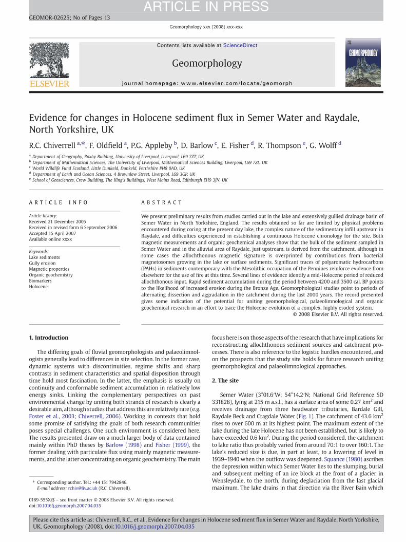
Semer Water (3°01.6′W; 54°14.2′N; National Grid Reference SD331828), lying at 215 m a.s.l., has a surface area of some 0.27 km2 andreceives drainage from three headwater tributaries, Bardale Gill,Raydale Beck and Cragdale Water (Fig. 1). The catchment of 43.6 km2
rises to over 600 m at its highest point. The maximum extent of thelake during the late Holocene has not been established, but is likely tohave exceeded 0.6 km2. During the period considered, the catchmentto lake ratio thus probably varied from around 70:1 to over 160:1. Thelake's reduced size is due, in part at least, to a lowering of level in1939–1940 when the outflow was deepened. Squance (1980) ascribesthe depression within which Semer Water lies to the slumping, burialand subsequent melting of an ice block at the front of a glacier inWensleydale, to the north, during deglaciation from the last glacialmaximum. The lake drains in that direction via the River Bain which
olocene sediment flux in Semer Water and Raydale, North Yorkshire,
Fig. 1. Location and relief of the Semer Water catchment. Outline box defines the extent of Fig. 3.
2 R.C. Chiverrell et al. / Geomorphology xxx (2008) xxx-xxx
ARTICLE IN PRESS
cuts through glacial moraine impounding the lake. The threeinflowing streams focus a highly developed drainage net into thehead of Raydale, to the south of the present day lake (Fig. 1).
The Upper Carboniferous limestones, shales and sandstones thatunderlie the catchment are extensively covered by glacial diamicts.There appears to have been only limited para- and periglacialremobilisation of these diamicts, with much of the glacial sediments inthe Raydale basin probably being an in situ fill and showing little of thesurface morphology, sediment fabric and stratification commonlyassociated with soliflucted diamicts. Since deglaciation, the rivers haveincised into the glacial deposits, giving rise to a series of fluviallandforms, river terraces and alluvial fans. At higher elevations, gentleslopes and summits are covered by blanket peat which is extensivelyeroded, often to the underlying bedrock. Where limestone crops outthere are sinkholes, as along the western flank of the catchment. TheRaydale valley bottom is covered by alluvium of mixed fluvial andlacustrine origin. Fig. 2 summarises the main features of the catchmentgeology. Over 90% of the catchment is grazed or used for hay/silage andless than 5% iswoodland,mainly sitka spruce planted between 1966 and1970 (Barlow,1998).Meanannual rainfall is of theorderof 1400mmyr−1.
3. Research methods
3.1. Catchment sampling for magnetic measurements
Forty-two samples were taken from sites in the lake catchment tocharacterise the properties of the sediment sources. All were mea-sured for a range of magnetic properties: bulk, low field susceptibility(χ), anhysteretic remanent magnetization (ARM), isothermal rema-
Please cite this article as: Chiverrell, R.C., et al., Evidence for changes in HUK, Geomorphology (2008), doi:10.1016/j.geomorph.2007.04.035
nent magnetization at 100 mT (IRM100) and saturation isothermalremanent magnetization (SIRM) using a field of 1 T. The quotientsARM/SIRM, ARM/ χ and IRM100/SIRM were also derived.
3.2. Bardale Gill: geomorphological mapping and palaeosol sampling
Thefluvial landformswithin the Bardale Gill tributarywere studiedto ascertain the postglacial geomorphic evolution of the catchment.The reach mapped (Fig. 3) extends up valley from the waterfall nickpoint just downstreamof theHebden Fold Gill tributary junction to theheavily eroded, peat-covered headwaters of Fleet Moss (see Fig. 2).Bardale Gill has cut a gully, which in places is 50 m across, into theglacial deposits intermittently exposed on both sides of the river. Theriver terraces and alluvial fans within this reach were mapped and thesediments described using available exposures. At three locations, twoalluvial fans and one river terrace, soils were encountered buriedbeneath fluvial gravels. Radiocarbon assays from such soils (Table 1)provide information about the age of underlying and overlyingdeposits (Harvey, 1996). Here we have dated the top horizon of thesoil and targeted the humic acid fraction of the soil organicmatter. Thehumic acid fraction produces younger age estimates for a buried soilthan other fractions, e.g. the humin fraction (Matthews, 1993), andprovides a ‘younger than’ estimate for the overlying sediments(Harvey, 1996). Throughout the paper, all new dates presented listthe original radiocarbon age determination in 14C years BP, and theseare listed in Table 1. These dates and others from the publishedresearch are presented as the 1-sigma calibrated age range in years BP,with all radiocarbon determinations calibrated to calendar years BP bythe authors using CALIB 5.0.1 (Stuiver et al., 2005).
olocene sediment flux in Semer Water and Raydale, North Yorkshire,

Fig. 2. Semer Water: simplified bedrock and Quaternary geology. The river outline also identifies the length and distribution of hillslope gully systems.
3R.C. Chiverrell et al. / Geomorphology xxx (2008) xxx-xxx
ARTICLE IN PRESS
3.3. Semer Water
The lake sedimentswere sampled using both aMackerethminicorerthat preserves an undisturbed sediment water interface, and a 6 mMackereth corer. The 18 minicores obtained fromwater depths rangingfrom 1.5 to 10.5 m, each provided between 55 cm and 85 cm of lateHolocene sediment. Three cores, T3 and two taken close to SL2 (Fig. 4)were analysed for 210Pb and 137Cs using gamma spectrometry (Applebyet al., 1986). All the minicores located in Fig. 4, were subsampled formagneticmeasurements.χ andARMweremeasured in all cases, the fullrange of measurements in two (cores 6 and 10), as well as in both of thelonger Mackereth cores. Core T3 was used for organic geochemistry. Itwas subsampled at 2 cm intervals (45 samples in total) and each samplewas analysed for C, H and N so that total organic carbon (TOC) contentand C/N ratios could be established. Lipids were extracted (Fisher, 1999;Fisher et al., 2003) from the sediments using organic solvents (23samples in total; 2 cm intervals for the top 20 cm, 4–10 cm intervalsbelow). Some lipids have specific biological origins and are referred to asbiomarkers. Thesewere used to determine the source of organic matterto the lake sediments. One additional 80 cm-long minicore from thedeepest part of the lake was subdivided into 20 cm lengths; the 4subsamples were then separated into particle size fractions rangingfrom b1 μm to N64 μm and each fraction subjected to magneticmeasurements using the dispersal, granulometric and magneticmeasurement procedures summarised in Yu and Oldfield (1993).
The two attempts to secure 6 m cores from the deepest part of thelake (SL1 and SL2 in Fig. 4) recovered only 2.2m and 2.4m of sediment,respectively, before the core tube reached densely compacted, impe-
Please cite this article as: Chiverrell, R.C., et al., Evidence for changes in HUK, Geomorphology (2008), doi:10.1016/j.geomorph.2007.04.035
netrable sediment. Two AMS radiocarbon dates were obtained on theshorter core of the two cores and three on the longer (Table 1).
3.4. Raydale
Thirty-two gouge cores and 3 Giddings cores were obtained fromRaydale (Fig. 4). Giddings core A and C confirmed that as far as 1.3 kmbeyond the southern edge of the current lake, over 10 m of partiallylacustrine Holocene sediments were present. The two gouge cores,shown in Fig. 4, confirm that the depth of fill some 400 m from thesouthern edge of the lake was in excess of 18 m. Further informationon the extent of the alluvial/lacustrine infill was obtained from a suiteof 13 resistivity profiles. Occasional peat lenses were observed insection in the main river channel, but not sampled.
Only the three Giddings cores were subsampled for analysis.Preliminary scans of a few samples from each core were carried outwith a view to identifying the main pollen types and constraining thechronologies. In addition, Core A, close to the position of the maininflowingstream,wasused fororganic geochemical analysis (30 samplesat ~30 cm resolution), magnetic measurements and granulometry, CoreC, less than 200m to the east was used for radiocarbon dating, magneticmeasurements and granulometry, and Core B, some 600 m to the north,was used for magnetic measurements and granulometry.
4. Chronological problems
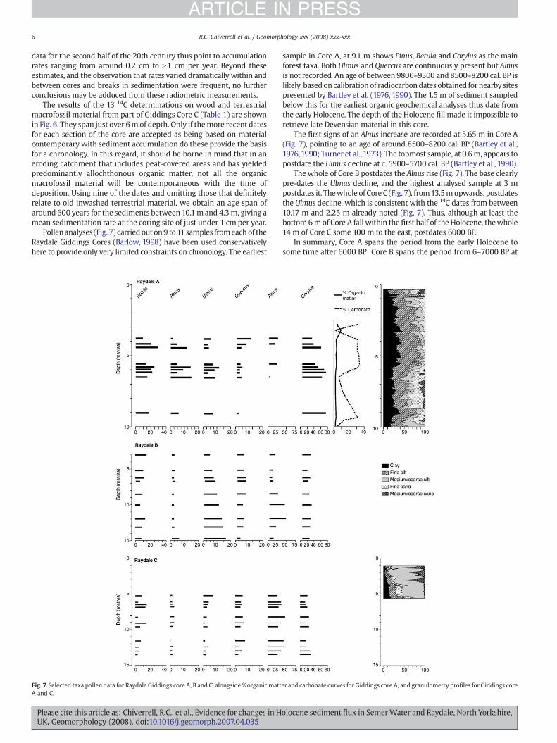
Two of the 210Pb and 137Cs profiles from Semer Water showed clearevidence for discontinuities in sedimentation (Fig. 5). These appear to
olocene sediment flux in Semer Water and Raydale, North Yorkshire,
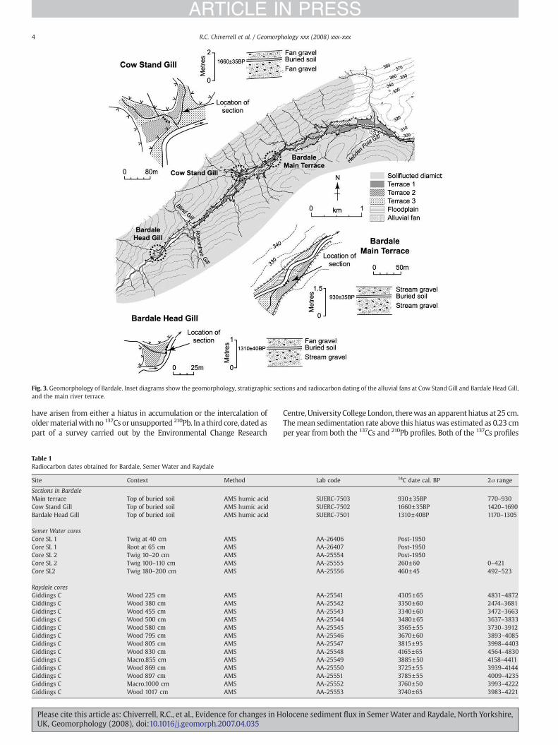
Fig. 3. Geomorphology of Bardale. Inset diagrams show the geomorphology, stratigraphic sections and radiocarbon dating of the alluvial fans at Cow Stand Gill and Bardale Head Gill,and the main river terrace.
4 R.C. Chiverrell et al. / Geomorphology xxx (2008) xxx-xxx
ARTICLE IN PRESS
have arisen from either a hiatus in accumulation or the intercalation ofoldermaterialwithno 137Csorunsupported 210Pb. In a third core, datedaspart of a survey carried out by the Environmental Change Research
Table 1Radiocarbon dates obtained for Bardale, Semer Water and Raydale
Site Context Method
Sections in BardaleMain terrace Top of buried soil AMS humic acidCow Stand Gill Top of buried soil AMS humic acidBardale Head Gill Top of buried soil AMS humic acid
Semer Water coresCore SL 1 Twig at 40 cm AMSCore SL 1 Root at 65 cm AMSCore SL 2 Twig 10–20 cm AMSCore SL 2 Twig 100–110 cm AMSCore SL2 Twig 180–200 cm AMS
Raydale coresGiddings C Wood 225 cm AMSGiddings C Wood 380 cm AMSGiddings C Wood 455 cm AMSGiddings C Wood 500 cm AMSGiddings C Wood 580 cm AMSGiddings C Wood 795 cm AMSGiddings C Wood 805 cm AMSGiddings C Wood 830 cm AMSGiddings C Macro.855 cm AMSGiddings C Wood 869 cm AMSGiddings C Wood 897 cm AMSGiddings C Macro.1000 cm AMSGiddings C Wood 1017 cm AMS
Please cite this article as: Chiverrell, R.C., et al., Evidence for changes in HUK, Geomorphology (2008), doi:10.1016/j.geomorph.2007.04.035
Centre, University College London, therewas an apparent hiatus at 25 cm.Themean sedimentation rate above this hiatuswas estimated as 0.23 cmper year from both the 137Cs and 210Pb profiles. Both of the 137Cs profiles
Lab code 14C date cal. BP 2σ range
SUERC-7503 930±35BP 770–930SUERC-7502 1660±35BP 1420–1690SUERC-7501 1310±40BP 1170–1305
AA-26406 Post-1950AA-26407 Post-1950AA-25554 Post-1950AA-25555 260±60 0–421AA-25556 460±45 492–523
AA-25541 4305±65 4831–4872AA-25542 3350±60 2474–3681AA-25543 3340±60 3472–3663AA-25544 3480±65 3637–3833AA-25545 3565±55 3730–3912AA-25546 3670±60 3893–4085AA-25547 3815±95 3998–4403AA-25548 4165±65 4564–4830AA-25549 3885±50 4158–4411AA-25550 3725±55 3939–4144AA-25551 3785±55 4009–4235AA-25552 3760±50 3993–4222AA-25553 3740±65 3983–4221
olocene sediment flux in Semer Water and Raydale, North Yorkshire,
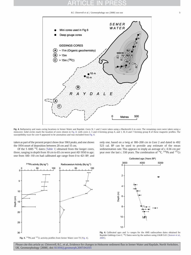
Fig. 4. Bathymetry and main coring locations in Semer Water and Raydale. Cores SL 1 and 2 were taken using a Mackereth 6 m corer. The remaining cores were taken using aminicorer. Solid circles mark the location of cores shown in Fig. 8; with cores 2, 3 and 4 forming group A, and 1, 10, 8 and 7 forming group B of these magnetic profiles. Thesusceptibility trace for core 9 appeared to be anomalous and was excluded from Fig. 8.
5R.C. Chiverrell et al. / Geomorphology xxx (2008) xxx-xxx
ARTICLE IN PRESS
takenaspart of thepresent project showclear 1963peaks, andone showsthe 1954 onset of deposition between 20 cm and 15 cm.
Of the 5 AMS 14C dates (Table 1) obtained from the longer cores,three, ranging in depth from 10 cm to 65 cmwere post AD 1950 in age;one from 100–110 cm had calibrated age range from 0 to 421 BP; and
Fig. 5. 210Pb and 137Cs activity profiles from Semer Water core T3 (Fig. 4).
Please cite this article as: Chiverrell, R.C., et al., Evidence for changes in HUK, Geomorphology (2008), doi:10.1016/j.geomorph.2007.04.035
only one, based on a twig at 180–200 cm in Core 2 and dated to 492523 cal. BP can be used to provide any estimate of the meansedimentation rate. This appears to imply an average of c. 0.36 cm peryear over the last c. 550 years. The combination of 14C, 210Pb and 137Cs
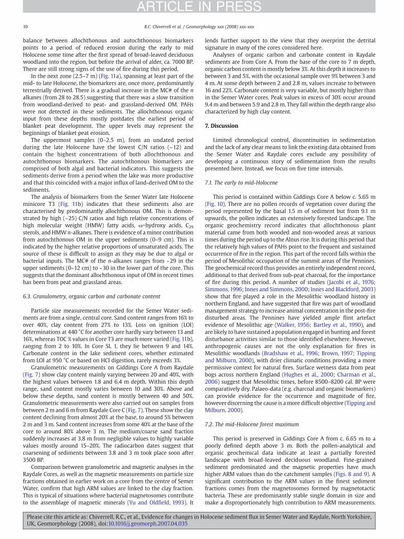
Fig. 6. Calibrated ages and 1σ ranges for the AMS radiocarbon dates obtained forRaydale Giddings Core C. 14C Dates were by the authors using CALIB 5.0.1 (Stuiver et al.,2005).
olocene sediment flux in Semer Water and Raydale, North Yorkshire,
6 R.C. Chiverrell et al. / Geomorphology xxx (2008) xxx-xxx
ARTICLE IN PRESS
data for the second half of the 20th century thus point to accumulationrates ranging from around 0.2 cm to N1 cm per year. Beyond theseestimates, and the observation that rates varied dramatically within andbetween cores and breaks in sedimentation were frequent, no furtherconclusions may be adduced from these radiometric measurements.
The results of the 13 14C determinations on wood and terrestrialmacrofossil material from part of Giddings Core C (Table 1) are shownin Fig. 6. They span just over 6m of depth. Only if themore recent datesfor each section of the core are accepted as being based on materialcontemporary with sediment accumulation do these provide the basisfor a chronology. In this regard, it should be borne in mind that in aneroding catchment that includes peat-covered areas and has yieldedpredominantly allochthonous organic matter, not all the organicmacrofossil material will be contemporaneous with the time ofdeposition. Using nine of the dates and omitting those that definitelyrelate to old inwashed terrestrial material, we obtain an age span ofaround 600 years for the sediments between 10.1m and 4.3m, giving amean sedimentation rate at the coring site of just under 1 cm per year.
Pollenanalyses (Fig. 7) carried out on9 to11 samples fromeachof theRaydale Giddings Cores (Barlow, 1998) have been used conservativelyhere to provide only very limited constraints on chronology. The earliest
Fig. 7. Selected taxa pollen data for Raydale Giddings core A, B and C, alongside % organic mattA and C.
Please cite this article as: Chiverrell, R.C., et al., Evidence for changes in HUK, Geomorphology (2008), doi:10.1016/j.geomorph.2007.04.035
sample in Core A, at 9.1 m shows Pinus, Betula and Corylus as the mainforest taxa. Both Ulmus and Quercus are continuously present but Alnusis not recorded. An age of between 9800–9300 and 8500–8200 cal. BP islikely, basedon calibration of radiocarbondatesobtained fornearby sitespresented by Bartley et al. (1976, 1990). The 1.5 m of sediment sampledbelow this for the earliest organic geochemical analyses thus date fromthe early Holocene. The depth of the Holocene fill made it impossible toretrieve late Devensian material in this core.
The first signs of an Alnus increase are recorded at 5.65 m in Core A(Fig. 7), pointing to an age of around 8500–8200 cal. BP (Bartley et al.,1976,1990; Turner et al.,1973). The topmost sample, at 0.6m, appears topostdate the Ulmus decline at c. 5900–5700 cal. BP (Bartley et al., 1990).
Thewhole of Core B postdates the Alnus rise (Fig. 7). The base clearlypre-dates the Ulmus decline, and the highest analysed sample at 3 mpostdates it. Thewhole of Core C (Fig. 7), from13.5mupwards, postdatesthe Ulmus decline, which is consistent with the 14C dates from between10.17 m and 2.25 m already noted (Fig. 7). Thus, although at least thebottom 6mof Core A fall within the first half of the Holocene, thewhole14 m of Core C some 100 m to the east, postdates 6000 BP.
In summary, Core A spans the period from the early Holocene tosome time after 6000 BP: Core B spans the period from 6–7000 BP at
er and carbonate curves for Giddings core A, and granulometry profiles for Giddings core
olocene sediment flux in Semer Water and Raydale, North Yorkshire,

7R.C. Chiverrell et al. / Geomorphology xxx (2008) xxx-xxx
ARTICLE IN PRESS
the base, to some unknown date post-6000 BP at the top; the base ofCore C postdates 6000 BP and its top postdates 3500 BP.
5. Landform evolution in Bardale Gill
The fluvial reach contains three levels of river terrace and severaltributary alluvial fans (Fig. 3). The first and highest terrace is present intwo locations, comprises coarse fluvial gravel, and is covered by soils ofsome maturity (Harvey et al., 1984). The second terrace is morewidespread, also comprisesfluvial gravel, but the overlying soil is thinnerand appears less mature. Sections exposed in the Bardale second terrace(Fig. 3) reveal two units of alluvial gravel separated by a buried brownearth soil some 10 cm in thickness. Radiocarbon dating of the humic acidfraction of the uppermost layers of this soil yielded a date of 770–930 cal.BP (930±35 BP: SUERC-7503) (Table 1). The third, and lowest, riverterrace describes a suite of landforms that is younger than the secondterrace, but varies in character from fairlymature features sustaining thinsoils to recently vegetated point-bars and abandoned channels.
Feeding into the valley there are a series of gullies cut into theglacial sediments, and where these tributaries meet the axial stream,alluvial fans have formed. At Cow Stand Gill the alluvial fan is acomplex multiple phase landform, with two surfaces. The deposits ofthe older surface are exposed (Fig. 3), and the sequence shows twounits of alluvial fan gravels separated by a 15 cm-thick brown earth
Fig. 8.Magnetic susceptibility (χ) and ARM/SIRM profiles for 10 of the cores (Group A and B)(B) areas of the lake. Tentative correlation lines have been marked, with the bolder ones su
Please cite this article as: Chiverrell, R.C., et al., Evidence for changes in HUK, Geomorphology (2008), doi:10.1016/j.geomorph.2007.04.035
soil. This fan surface grades to the second river terrace. The uppermostlayers of the soil were sampled for 14C dating, and the humic acidfraction yielded a date of 1690–1420 cal. BP (1660±35 BP: SUERC . Thealluvial fan at Bardale Head Gill also comprises two phases of fanformation, and here the younger, lower surface has exposure thatshows two units of alluvial fan gravel separated by a 5 cm-thick soil.The humic acid fraction of this soil has been dated to 1305–1170 cal. BP(1310±40 BP: SUERC-7501).
The sequence of events in the postglacial evolution of the BardaleGill is resolved, in the present study, into two broad phases. During thelate glacial and early Holocene the river incised, either gradually orrapidly, after which there was a considerable period of stability. Thefirst river terrace is a remnant feature, the gravels of which wereprobably lain down during late glacial or early Holocene times. Thethickness of soil overlying this feature implies abandonment andincision probably during the early to mid-Holocene, and it pre-datesthe lower gravels of the higher fan surface at Cow Stand Gill dated tobefore 1690–1420 cal. BP. During the late Holocene the riverexperienced cycles of aggradation and incision, with phases of gravelaggradation associated with the second and third suite of terracesdated. Dating of the second terrace deposits indicates phases of gravelaggradation before and after a period of stability that ended after 930770 cal. BP. It has not been possible to secure the timing of the onset ofgullying in the tributary systems, with gravel aggradation associated
identified on Fig. 4. They are grouped into sets from the south-western (A) and northernpported by trends in both χ and ARM/SIRM.
olocene sediment flux in Semer Water and Raydale, North Yorkshire,

Fig. 9. Biplots of magnetic properties in the sediment cores and catchment samplesfrom Semer Water and Raydale. The upper two graphs compare the Semer Water andcatchment properties. Note the generally higher ARM/SIRM and especially ARM/χquotients in the sediments in (a) and the much wider scatter and generally much lowervalues of IRM100 mT/SIRM in (b) and (c) also includes quotients from the three RaydaleGiddings cores. All but the values from Core C show ARM values well outside thecatchment envelope.
8 R.C. Chiverrell et al. / Geomorphology xxx (2008) xxx-xxx
ARTICLE IN PRESS
with the higher fan terrace before 1690–1420 cal. BP at Cow Stand Gill.The phase of relative stability represented by soil accumulation wasfollowed by further gravel aggradation, again associated with thehigher fan terrace, after 1690–1420 cal. BP. The surface of this alluvialfan terrace appears to grade to the second river terrace, which issuggestive of some equivalence between these landforms. The CowStand Gill gully system has incised into the higher fan terraceproducing a lower surface that grades to the third river terrace,which clearly postdates 930–770 cal. BP. Geochronological control forthe alluvial fan sequence at Bardale Head Gill is only available for thedeposits of the lower fan surface, and so the onset of gully incisionclearly pre-dates 1305–1170 cal. BP, and there is evidence for renewedalluvial fan development after that date.
6. Analytical results
6.1. Magnetic measurements
Fig. 8 shows plots of χ and ARM/SIRM based on measuredsubsamples at 2–3 cm depth intervals from 7 of the Semer Waterminicores. They are grouped into two sets, each of which is separatelyidentified in the location map. Within each set, lines have been drawnlinking horizons for which correlations are supported by each of theindependently derivedmagnetic properties. There are indications thatdeposition was reasonably conformable over each of the twotransects. Difficulty in correlating magnetic profiles from the remain-ing cores, including those from deeper water in the centre of the lake,is consistent with the problems encountered in interpreting theradiometric data from this part of the lake (see above).
Fig. 9 summarises the results of susceptibility and remanencemeasurements on samples from the catchment and from the lake andRaydale cores. The bi-variate plots show the extent to which theenvelope of values for each set of sediment core measurements lieswithin or extends beyond the range of values for the catchmentsamples. The lake sediment samples generally have higher ARMvalues relative to both χ and SIRM than do the catchment samples.Moreover, values for ARM and ARM/SIRM in all the cores, save Core C,from Raydale include the majority of samples that lie outside thecatchment envelope. These features show that most of the lakesediments and those from Raydale Cores A and B have a significantmagnetite contribution from magnetosomes produced by magneto-tactic bacteria growing within the lake or surface sediments (cf. vander Post et al., 1997; Oldfield and Wu 2000; Oldfield et al., 2003) andproducing mainly stable single domain magnetite with a dispropor-tionately high ARM (Maher, 1988). On the other hand, most of thecatchment samples have a ‘harder’ isothermal remanence mainlyattributable to a higher contribution from haematite. This reflects theextent to which catchment sampling included material from subsoilsand unweathered parent material.
Fig. 10 compares the values for ARM/χ, ARM/SIRM and IRM100 mT/SIRM in the mid-Holocene part of Giddings Core A (below) and the14C-dated (c. 4200–3500 cal. BP) part of Core C (above) withcatchment values for the same quotients. These plots reinforce theconclusion that only in the case of Raydale Core C do the magneticmeasurements reflect allochthonous input that has not been sig-nificantly modified by the addition of bacterially derived magnetite.
6.2. Organic geochemistry (Fig. 11)
In the present account, inferences regarding organic matter (OM)provenance have been based on the evidence and interpretationsdiscussed more fully by Fisher et al. (2003) and the sources quotedtherein.
C/N ratios in Raydale Giddings Core A range from 12–19. Thissuggests that the dominant source of OM is from catchment-derivedvascular plants. The biomarkers are also dominated by indicators of
Please cite this article as: Chiverrell, R.C., et al., Evidence for changes in HUK, Geomorphology (2008), doi:10.1016/j.geomorph.2007.04.035
allochthonous OM, e.g. ω-hydroxy acids, pentacyclic triterpenoidalcohols and ketones, C29 sterols and HMW fatty acids. However, therelative concentrations of biomarkers vary considerably down-core:
In the deepest sediments (9.5–10.5 m) the biomarkers are entirelydominated by indicators of allochthonous inputs (Fig. 11a). Auto-chthonous biomarkers were not detected in these sediments. Thesediments also contain high concentrations (0.4 mg/g TOC) ofpolycyclic aromatic hydrocarbons (PAHs). These form when wood,or, in modern times, coal or petroleum is burnt under oxygen deficientconditions (Baek et al., 1991). Those present in the highest concentra-tions in Raydale sediments are phenanthrene, benzo(b)fluoranthene,dibenz(ah)anthracene, chrysene, benzo(ghi)perylene and pyrene. Theconcentration of PAHs falls to 0.05 mg/g TOC at the top of this zone(9.5 m). There is also a gradual change in the mean carbon number(MC#) of the n-alkanes (from 29.25 to 28.25) suggesting that a changemay have occurred in the source of the organic matter, from peat andgrassland to woodland, consistent with the development of forestcover during the early Holocene.
From 7–8.5 m (Fig. 11a), the concentration of allochthonousbiomarkers is virtually undetectable. However, there is an increase
olocene sediment flux in Semer Water and Raydale, North Yorkshire,

Fig. 10. Down-core traces of ARM/χ, ARM/SIRM and IRM100 mT/SIRM for parts of Raydale Giddings Cores A (below) and C (above) compared with the mean values for catchmentsamples shown as grey shading. In all cases, high quotient values are likely to reflect a stronger contribution from bacterial magnetosomes and/or surface soils. The lower values aretypical of catchment subsoils and parent material. They reflect the high content of haematite in these materials.
9R.C. Chiverrell et al. / Geomorphology xxx (2008) xxx-xxx
ARTICLE IN PRESS
in the relative concentration of bacterial indicators (e.g. β-hydroxyacids and iso and anteiso acids). The sediments are also characterisedby high concentrations of PAHs (0.4 mg/g TOC). The MC# of the n
Fig. 11. Down-core profiles of Mean Carbon Number (MC#) of the n-alkanes and polycyclicalkanes suggest a high contribution of organic matter (OM) from woodlands, whereas highconcentrations of PAHs suggest the use of fire in the catchment. + add in short core MC n-a
Please cite this article as: Chiverrell, R.C., et al., Evidence for changes in HUK, Geomorphology (2008), doi:10.1016/j.geomorph.2007.04.035
alkanes is very variable and ranges from 28 to 29.6. This suggests thatboth forested and unforested parts of the catchment contributedorganic matter to the sediments during this period. The changed
aromatic hydrocarbons (PAHs) from Raydale Giddings Core A. Low values of MC# n-values suggest that peat and grass are the main sources of OM to the sediment. Highlkanes and TOC%.
olocene sediment flux in Semer Water and Raydale, North Yorkshire,
10 R.C. Chiverrell et al. / Geomorphology xxx (2008) xxx-xxx
ARTICLE IN PRESS
balance between allochthonous and autochthonous biomarkerspoints to a period of reduced erosion during the early to midHolocene some time after the first spread of broad-leaved deciduouswoodland into the region, but before the arrival of alder, ca. 7000 BP.There are still strong signs of the use of fire during this period.
In the next zone (2.5–7 m) (Fig. 11a), spanning at least part of themid- to late Holocene, the biomarkers are, once more, predominantlyterrestrially derived. There is a gradual increase in the MC# of the nalkanes (from 28 to 28.5) suggesting that there was a slow transitionfrom woodland-derived to peat- and grassland-derived OM. PAHswere not detected in these sediments. The allochthonous organicinput from these depths mostly postdates the earliest period ofblanket peat development. The upper levels may represent thebeginnings of blanket peat erosion.
The uppermost samples (0–2.5 m), from an undated periodduring the late Holocene have the lowest C/N ratios (~12) andcontain the highest concentrations of both allochthonous andautochthonous biomarkers. The autochthonous biomarkers arecomprised of both algal and bacterial indicators. This suggests thesediments derive from a period when the lake was more productiveand that this coincided with a major influx of land-derived OM to thesediments.
The analysis of biomarkers from the Semer Water late Holoceneminicore T3 (Fig. 11b) indicates that these sediments also arecharacterised by predominantly allochthonous OM. This is demon-strated by high (~25) C/N ratios and high relative concentrations ofhigh molecular weight (HMW) fatty acids, ω−hydroxy acids, C29
sterols, and HMW n-alkanes. There is evidence of aminor contributionfrom autochthonous OM in the upper sediments (0–9 cm). This isindicated by the higher relative proportions of unsaturated acids. Thesource of these is difficult to assign as they may be due to algal orbacterial inputs. The MC# of the n-alkanes ranges from ~29 in theupper sediments (0–12 cm) to ~30 in the lower part of the core. Thissuggests that the dominant allochthonous input of OM in recent timeshas been from peat and grassland areas.
6.3. Granulometry, organic carbon and carbonate content
Particle size measurements recorded for the Semer Water sedi-ments are from a single, central core. Sand content ranges from 16% toover 40%, clay content from 27% to 13%. Loss on ignition (LOI)determinations at 440 °C for another core hardly vary between 13 and16%, whereas TOC % values in Core T3 are much more varied (Fig. 11b),ranging from 2 to 10%. In Core SL 1, they lie between 9 and 14%.Carbonate content in the lake sediment cores, whether estimatedfrom LOI at 950 °C or based on HCl digestion, rarely exceeds 3%.
Granulometric measurements on Giddings Core A from Raydale(Fig. 7) show clay content mainly varying between 20 and 40%, withthe highest values between 1.8 and 6.4 m depth. Within this depthrange, sand content mostly varies between 10 and 30%. Above andbelow these depths, sand content is mostly between 40 and 50%.Granulometric measurements were also carried out on samples frombetween 2m and 6m fromRaydale Core C (Fig. 7). These show the claycontent declining from almost 20% at the base, to around 5% between2 m and 3 m. Sand content increases from some 40% at the base of thecore to around 80% above 3 m. The medium/coarse sand fractionsuddenly increases at 3.8 m from negligible values to highly variablevalues mostly around 15–20%. The radiocarbon dates suggest thatcoarsening of sediments between 3.8 and 3 m took place soon after3500 BP.
Comparison between granulometric and magnetic analyses in theRaydale Cores, as well as the magnetic measurements on particle sizefractions obtained in earlier work on a core from the centre of SemerWater, confirm that high ARM values are linked to the clay fraction.This is typical of situations where bacterial magnetosomes contributeto the assemblage of magnetic minerals (Yu and Oldfield, 1993). It
Please cite this article as: Chiverrell, R.C., et al., Evidence for changes in HUK, Geomorphology (2008), doi:10.1016/j.geomorph.2007.04.035
lends further support to the view that they overprint the detritalsignature in many of the cores considered here.
Analyses of organic carbon and carbonate content in Raydalesediments are from Core A. From the base of the core to 7 m depth,organic carbon content is mostly below 3%. At this depth it increases tobetween 3 and 5%, with the occasional sample over 9% between 3 and4 m. At some depth between 2 and 2.8 m, values increase to between16 and 22%. Carbonate content is very variable, but mostly higher thanin the Semer Water cores. Peak values in excess of 30% occur around9.4m and between 5.9 and 2.8m. They fall within the depth range alsocharacterized by high clay content.
7. Discussion
Limited chronological control, discontinuities in sedimentationand the lack of any clear means to link the existing data obtained fromthe Semer Water and Raydale cores exclude any possibility ofdeveloping a continuous story of sedimentation from the resultspresented here. Instead, we focus on five time intervals.
7.1. The early to mid-Holocene
This period is contained within Giddings Core A below c. 5.65 m(Fig. 10). There are no pollen records of vegetation cover during theperiod represented by the basal 1.5 m of sediment but from 9.1 mupwards, the pollen indicates an extensively forested landscape. Theorganic geochemistry record indicates that allochthonous plantmaterial came from both wooded and non-wooded areas at varioustimes during the period up to the Alnus rise. It is during this period thatthe relatively high values of PAHs point to the frequent and sustainedoccurrence of fire in the region. This part of the record falls within theperiod of Mesolithic occupation of the summit areas of the Pennines.The geochemical record thus provides an entirely independent record,additional to that derived from sub-peat charcoal, for the importanceof fire during this period. A number of studies (Jacobi et al., 1976;Simmons,1996; Innes and Simmons, 2000; Innes and Blackford, 2003)show that fire played a role in the Mesolithic woodland history innorthern England, and have suggested that fire was part of woodlandmanagement strategy to increase animal concentration in the post-firedisturbed areas. The Pennines have yielded ample flint artefactevidence of Mesolithic age (Walker, 1956; Bartley et al., 1990), andare likely to have sustained a population engaged in hunting and forestdisturbance activities similar to those identified elsewhere. However,anthropogenic causes are not the only explanation for fires inMesolithic woodlands (Bradshaw et al., 1996; Brown, 1997; Tippingand Milburn, 2000), with drier climatic conditions providing a morepermissive context for natural fires. Surface wetness data from peatbogs across northern England (Hughes et al., 2000; Charman et al.,2006) suggest that Mesolithic times, before 8500–8200 cal. BP werecomparatively dry. Palaeo-data (e.g. charcoal and organic biomarkers)can provide evidence for the occurrence and magnitude of fire,however discerning the cause is amore difficult objective (Tipping andMilburn, 2000).
7.2. The mid-Holocene forest maximum
This period is preserved in Giddings Core A from c. 6.65 m to apoorly defined depth above 3 m. Both the pollen-analytical andorganic geochemical data indicate at least a partially forestedlandscape with broad-leaved deciduous woodland. Fine-grainedsediment predominated and the magnetic properties have muchhigher ARM values than do the catchment samples (Figs. 8 and 9). Asignificant contribution to the ARM values in the finest sedimentfractions comes from the magnetosomes formed by magnetotacticbacteria. These are predominantly stable single domain in size andmake a disproportionately high contribution to ARM measurements.
olocene sediment flux in Semer Water and Raydale, North Yorkshire,
11R.C. Chiverrell et al. / Geomorphology xxx (2008) xxx-xxx
ARTICLE IN PRESS
Oldfield et al. (2003) showed that such magnetic assemblages areassociated with minimum allochthonous particulate input. Thecombined magnetic and granulometric record from this part of CoreA thus points to a period of landscape stability and limited clasticinput via the main inflowing river. This is also the period of maximumcarbonate concentration in Core A. A stable landscape with asignificant solute input from the limestone slopes along the westernside of the catchment is indicated.
Land-use change, climate and storms are regarded as the maintriggers for phases of increased fluvial geomorphic activity (Harveyet al., 1981; Macklin, 1999; Lewin et al., 2005; Chiverrell et al., 2007).Storms often are the trigger for gully incision, but the radiocarbondating of upland alluvial fans across northwest England shows thatepisodes of gully incision are concentrated in the late Holocene andhave been attributed to localised responses to land-use change duringthe late Holocene (Harvey et al., 1981; Harvey, 1996; Chiverrell et al.,2007). The geomorphic evidence in Bardale relating to the early tomid-Holocene is somewhat ambiguous, with no comprehensivegeochronological control. However, a period of relative geomorphicstability as interpreted from the palaeolimnological data during earlyto mid-Holocene times is in keeping with investigations of othernearby upland river systems (Harvey et al., 1981; Harvey and Renwick,1987; Chiverrell et al., 2007).
7.3. The period from c. 4100 to 3500 cal. BP
Ascribing dates to the interval spanned by the sediments between4 m and 9 m in Core C rests on assumptions about the validity ofseveral of the 14C dates from that core, and it is possible that the timeinterval represented is somewhat younger in age. A partiallydeforested landscape is indicated by the pollen record. Pollen datafrom sites in Wensleydale identify major clearances dated to theBronze Age c. 4440–4160 cal. BP (Honeyman, 1985), and lowlandsaround Airedale to 4080–3730 cal. BP (Bartley et al., 1990). The wholeof the dated interval just precedes the sharp increase in the coarsesand fraction at 3.8 m noted above. Nevertheless all the signs from themagnetic measurements (Figs. 8 and 9) are that the sediment iscatchment-derived and, bearing in mind also the high sedimentationrate recorded, close to 1 cm per year, this represents a period of quitesevere erosion. Similar magnetic properties characterize the upper,undated part of the core. There is tentative geomorphic evidence forerosion and aggradation during the late Holocene within Bardale, theonset of which has not been constrained other than it pre-dates 16901420 cal. BP. If as elsewhere in the uplands of northern England, theinception of tributary gullies systems has been linked with anthro-pogenic woodland clearance and destabilisation of the hillslopes(Harvey, 1996; Chiverrell et al., 2007), then it is a plausible hypothesishere but it requires further testing.
7.4. The period from c. 2000 to 100 cal. BP
The geochronological control for the geomorphic evidence inBardale can at present only be regarded as tentative, neverthelessmuch of the evidence relates to the last 2000 years. Radiocarbondating of buried mineral soils can secure a chronology for lateHolocene landforms (Matthews, 1993; Harvey, 1996), however duecaution is required in case the soils have been truncated by erosion orreceived younger organic matter from overlying soils. By analysinghumic acids the radiocarbon dating targets the youngest organicfraction within buried soils (Matthews, 1993; Harvey, 1996), but doesnot preclude the possibility of residence time in the accumulation oforganic matter. Nevertheless, the overlying deposits and youngerlandforms postdate the age determinations produced for each buriedsoil horizon. Laterally extensive buried soils between the accumula-tion of alluvial gravel units reflect that the Cow Stand Gill alluvial fanwent through a phase of stability that ended after 1690–1420 cal. BP,
Please cite this article as: Chiverrell, R.C., et al., Evidence for changes in HUK, Geomorphology (2008), doi:10.1016/j.geomorph.2007.04.035
and elsewhere within Bardale similar stability episodes ended after930–770 cal. BP in the case of the main river terrace. The subsequentincision phase and further gravel aggradation associated with thedeposits of the third river terrace is constrained to after 930–770 cal.BP. In summary the sequence can be interpreted as reflectingincreased geomorphic activity during the late Holocene.
The lacustrine evidence for this period is somewhat limited atpresent, but cores from the centre of Semer Water show that rapidaccumulation of sandy sediments have occurred through at least thelast 500 years. The alluvial delta that comprises the valley floor ofRaydale will include a substantial body of sediment that aggraded atthis time. Supporting geomorphic evidence for heightened geo-morphic instability during the late Holocene is available from theSwale/Ure confluence at Myton-on-Swale (Taylor et al., 2000), whereboreholes show considerable accumulation (6 m) of fine-grainedalluvial sediment during the period after 930–730 cal. BP. The recorddiscerned for other nearby upland areas, the Forest of Bowland(Harvey and Renwick, 1987; Chiverrell et al., 2007) and the HowgillFells (Harvey, 1996; Chiverrell et al., 2007), contains extensiveevidence for heightened geomorphic activity and hillslope instabilityafter dates that span the period 1400–800 cal. BP and this coincideswith evidence for population expansion and increased upland landusage during Anglo-Norse and later times (Winchester, 1987;Chiverrell et al., 2007). Pollen data for this time period are notavailable for Semer Water, and more widely well-dated palaeoecolo-gical evidence is not abundant across the region. Sites in Nidderdaleidentify further substantial woodland clearances dated to c.1060805 cal. BP (Tinsley, 1975), and in lowlands around Ribblesdale thefirst substantial woodland clearances took place 1515–1290 cal. BP(Bartley et al., 1990). Tinsley (1975) suggests that many of the uppertributary valleys and probably the steeper slopes retained woodlandcover until these clearances. This apparent coincidence between thepalaeoecological evidence for anthropogenically induced vegetationchange, and both limnological and geomorphic evidence for landscapeinstability with the catchment of SemerWater can only be regarded astentative at present.
7.5. The 20th century
The record for this time interval is disjointed and comes entirelyfrom the Semer Water cores. Some cores at least experiencedsedimentation rates during the second half of the century that werecomparable to those dating from 4000–3000 cal. BP in Giddings CoreC. The magnetic record shows clear signs both of a high detrital inputand some bacterial overprinting, varying with depth. The organicgeochemistry indicates that the sediments are characterised bypredominantly allochthonous biomarkers. There is a minor contribu-tion from autochthonous OM in the surficial sediments demonstratedby lower C/N ratios and higher proportions of unsaturated acids. Thissuggests that enhanced lake productivity may have occurred in recenttimes. However, as the first appearance of the autochthonousbiomarkers coincides with the hiatus in the core, it is difficult todetermine a timescale for this.
8. Conclusions
Deposition in the Raydale/Semer Water system is a complexmixture of alluvial, deltaic and fine-grained lacustrine material, withstrong temporal and spatial variations in particle size, organic carbonand carbonate content. Comparison of the time intervals spanned byeach set of cores shows that deposition has been at least partiallyprogradational during the Holocene. Thus, although all the evidencesuggests that fluvial incision and gully erosion of glacial diamict islikely to have been the dominant sediment source during theHolocene, attempts to refine this from the sediment record forspecific time intervals on a quantitative basis will be difficult.
olocene sediment flux in Semer Water and Raydale, North Yorkshire,
12 R.C. Chiverrell et al. / Geomorphology xxx (2008) xxx-xxx
ARTICLE IN PRESS
Radiocarbon measurements based on terrestrial macrofossils andwood from the only dated Raydale core point to rapid sedimentation c.4200–3200 cal. BP (of the order of 1 cm yr−1) as well as to theincorporation of ‘old’ macroscopic material pre-dating the time ofsediment accumulation. Improving chronological control will require,wherever possible, discrimination between terrestrial material con-temporary with sedimentation and that derived from the erosion ofstable organic residues in catchment soils and blanket peat. The SemerWater system provides a context within which to explore the onsetand history of the erosion of Pennine summit blanket peat, but thiswill require unambiguous recognition of eroded peat whetherthrough microscopic analysis or improved biomarker ‘fingerprinting’.The combined indications from 210Pb, 137Cs and 14C measurementscarried out on the SemerWater cores point to discontinuities in recentsedimentation, although the magnetic susceptibility traces indicatethat there are areas of conformable sedimentation within the lake.137Cs and 14C data from the Semer Water Cores show that the depthrange of post-1950 sediments varies from c.15 cm to N60 cm. The onlydemonstrably pre-modern 14C date from the Semer Water corespoints to the accumulation of some 2 m of sediment during the last550 years in one of the central cores.
Although in many cores, the magnetic properties show over-printing of catchment ‘signatures’ by bacterial magnetosomes, themagnetic properties of a significant proportion of the Raydalesediments, from Core C in particular, correspond well with those ofcatchment-derived material. In this case, any in situ production ofbacterial magnetite has been swamped by the volume of allochtho-nous material deposited. Biomarker data suggest that the dominantsource of organic material in both the lake and Raydale sedimentsequences is terrestrial. The only likely exception is the most recent(post-1950) Semer Water sediment, probably as a consequence ofrecent eutrophication. Early to mid-Holocene biomarkers indicate atleast a partially wooded landscape as the dominant source ofallochthonous organic matter. Stronger evidence for organic materialderived from grassland and/or peat sources appears later in thesequence (as well as in the earliest part, pre-dating pollen records ofmixed deciduous and pinewoodland). The peaks in PAH present in thepre-Alnus rise Raydale sediment record provide evidence for theimportance of fire in the region during the Mesolithic.
The evidence for catchment instability during the last 2000 years isnot fullymatched by any of the lacustrine sequences studied so far. TheRaydale cores sampled and dated, whether by radiocarbon or morecrudely by pollen counts, are mostly too old, and the oldest materialdated from SemerWater itself is only 550 years old. However, the bulkof the Raydale infill lies between the present southern limits of the lakeand the Raydale cores analysed. Moreover, gouge cores have alreadyproved sediment depths in excess of 16–18 m in parts of this fill.Clearly, it is to this part of the system that attentionmust turn in futurein order to link the geomorphic and palaeolimnological records moreclosely. Developing secure quantitative estimates of total sedimenta-tion for key episodes during the Holocene will depend on compre-hensive coring of both the Raydale and sub-aquatic sediments at leastto the Late Devensian/Holocene contact. Given the complex inter-digitation of limnic, prograding deltaic and fluvial sediments inRaydale, this will require not only multiple cores, but extensivechronological control. Successful coring of the currently sub-aquaticsediments calls for raft-based equipment capable of penetrating andretrieving cores from extremely cohesive material. Finally, success inbringing the historyof sedimentation up to the present daywill requirea series of cores spanning the last two centurieswithout any significanthiatus. This has proved difficult so far, despite multiple magneticprofiles and detailed radioisotope measurements.
One of the key outcomes of this account is a demonstration of thepotential of the site for further work linking geomorphological andpalaeolimnological studies within the same lake-catchment frame-work. Organic biogeochemistry can identify the key linkages, since the
Please cite this article as: Chiverrell, R.C., et al., Evidence for changes in HUK, Geomorphology (2008), doi:10.1016/j.geomorph.2007.04.035
results relate to the nature and provenance of organic material in thesediment, not simply to the general nature of catchment vegetation, asis the case with pollen analysis. More research is likely to revealimportant pointers both from the changing relative proportions ofdifferent allochthonous OM biomarkers and from their relativerichness or paucity as a whole. For example, where the sediment isimpoverished in biomarkers, despite strong indications of erosionfrom other lines of evidence, one likely inference would be that thesediments were largely derived, as in this study, from channel bankand gully erosion rather than erosion of surface soil. Such evidencecomplements that provided by magnetic measurements on theminerogenic sediments (cf. Oldfield et al., 2003). At the same time,these preliminary results force acknowledgement of the formidablechallenges posed by such a complex site if any attempt is made tounite the geomorphic and palaeolimnological evidence into acoherent and continuous, quantified account of erosion, sedimentyields and sources, and Holocene denudational processes.
Acknowledgements
We thank Andy Plater for help with coring the Raydale sediments,Shiva Patil for some of the magnetic measurements carried out on theSemer Water cores and Sandra Mather for producing the majority ofthe diagrams. Reviews by Richard Tipping and Adrian Harvey helpedus to significantly improve the paper. Most of the work presented herewas funded by NERC Grant No GST/02/754 as part of the LOEPS SpecialTopic.
References
Appleby, P.G., Nolan, P.J., Gifford, D.W., Godfrey, M.J., Oldfield, F., Anderson, N.J.,Battarbee, R.W., 1986. 210Pb dating by low background gamma counting.Hydrobiolgia 143, 21–27.
Baek, S.O., Field, R.A., Goldstone, M.E., Kirk, M.E., Lester, J.N., Perry, R., 1991. A review ofatmospheric polycyclic aromatic hydrocarbons: sources, fate and behaviour. WaterAir and Soil Pollution 60, 279–300.
Barlow, D., 1998. A lake sediment study of particulate flux in the Humber Catchment,using magnetic measurements. Ph.D. thesis, University of Edinburgh, 313p.
Bartley, D.D., Chambers, C., Hart-Jones, B., 1976. The vegetation history of parts of southand east Durham. New Phytologist 77, 437–468.
Bartley, D.D., Jones, I.P., Smith, R.T., 1990. Studies in the Flandrian vegetational history ofthe Craven district of Yorkshire: the lowlands. Journal of Ecology 78, 611–632.
Bradshaw, R.H.W., Tolonen, K., Tolonen, M., 1996. Holocene records of fire from theboreal and temperate zones of Europe. In: Clark, J.S., Cachier, H., Goldammer, J.G.,Stocks, B. (Eds.), Sediment Records of Biomass Burning and Global Change. Springer,Berlin, pp. 347–365.
Brown, A., 1997. Clearances and clearings: deforestation in mesolithic/neolithic Britain.Oxford Journal of Archaeology 16, 133–146.
Charman, D.J., Blundell, A., Chiverrell, R.C., Hendon, D., Langdon, P.G., 2006. Compilationof non-annually resolved Holocene proxy climate records: stacked Holocenepeatland palaeo-water table reconstructions from northern Britain. QuaternaryScience Reviews 25, 336–350.
Chiverrell, R.C., 2006. Past and future perspectives upon landscape instability inCumbria, northwest England. Regional Environmental Change 6, 101–114.
Chiverrell, R.C., Harvey, A.M., Foster, G.C., 2007. Hillslope gullying in the Solway FirthMorecambe Bay region: responses to human impact and/or climatic deterioration?Geomorphology 84, 317–343.
Fisher, E., 1999. The impact of land use changes on lacustrine organic chemistry. Ph.D.thesis, University of Liverpool, 182p.
Fisher, E., Wake, R., Oldfield, F., Appleby, P.G., Boyle, J., Wolff, G., 2003. Molecular markerrecords of land use change. Organic Geochemistry 34, 105–119.
Foster, G.C., Dearing, J.A., Jones, R.T., Crook, D.S., Siddle, D.J., Harvey, A.M., James, P.A.,Appleby, P.G., Thompson, R., Nicholson, J., Loizeau, J.L., 2003. Meteorological andland-use controls on past and present hydro-geomorphic processes in the prealpine environment: an integrated lake-catchment study at the Petit Lac d'Annecy,France. Hydrological Processes 17, 3287–3305.
Harvey, A.M., 1996. Holocene hillslope gully systems in the Howgill Fells, Cumbria.In: Brooks, S.M., Anderson, M.G. (Eds.), Advances in Hillslope Processes, vol. 2.Wiley, Chichester, pp. 731–752.
Harvey, A.M., Renwick, W.H., 1987. Holocene alluvial fan and terrace formation in theBowland Fells, Northwest England. Earth Surface Processes and Landforms 12,249–257.
Harvey, A.M., Oldfield, F., Baron, A.F., Pearson, G., 1981. Dating of post-glacial landformsin the central Howgills. Earth Surface Processes and Landforms 6, 401–412.
Harvey, A.M., Alexander, R.W., James, P.A., 1984. Lichens, soil development and the ageof Holocene valley floor landforms: Howgill Fells, Cumbria. Geografiska Annaler66A, 353–366.
olocene sediment flux in Semer Water and Raydale, North Yorkshire,

13R.C. Chiverrell et al. / Geomorphology xxx (2008) xxx-xxx
ARTICLE IN PRESS
Honeyman, A. 1985. Studies in the Holocene vegetation history of Wensleydale. Ph.D.thesis, University of Leeds. 323p.
Hughes, P.D.M., Mauquoy, D., Barber, K.E., Langdon, P.G., 2000. Mire-developmentpathways and palaeoclimatic records from a full Holocene peat archive at WaltonMoss, Cumbria, England. The Holocene 10, 465–479.
Innes, J.B., Blackford, J.J., 2003. The ecology of late Mesolithic woodland disturbances:model testing with fungal spore assemblage data. Journal of Archaeological Science30, 185–194.
Innes, J.B., Simmons, I.G., 2000. Mid-Holocene charcoal stratigraphy, fire history andpalaeoecology at North Gill, North York Moors, UK. Palaeogeography, Palaeoclima-tology, Palaeoecology 164, 151–165.
Jacobi, R.M., Tallis, J.H., Mellars, P.A., 1976. The southern Pennine Mesolithic and theecological record. Journal of Archaeological Science 3, 307–320.
Lewin, J., Macklin, M.G., Johnstone, E., 2005. Interpreting alluvial archives: sedimento-logical factors in the British Holocene fluvial record. Quaternary Science Reviews24, 1873–1889.
Macklin, M.G., 1999. Holocene river environments in prehistoric Britain: humaninteraction and impact. In: Edwards, K.J., Sadler, J.P. (Eds.), Holocene Environment ofPrehistoric Britain. . Quaternary Proceedings No 7. Wiley, Chichester, pp. 521–530.
Maher, B.A., 1988. Magnetic properties of some synthetic sub-micron magnetites.Geophysical Journal 94, 83–96.
Matthews, J.A., 1993. Radiocarbon dating of arctic-alpine palaeosols and thereconstruction of Holocene palaeoenvironmental change. In: Chambers, F.M.(Ed.), Climate Change and Human Impact on the Landscape. Chapman and Hall,London, pp. 83–100.
Oldfield, F., Wu, R., 2000. The magnetic properties of the recent sediments of BrothersWater, N.W. England. Journal of Paleolimnology 23, 165–174.
Oldfield, F.,Wake, R., Boyle, J., Jones, R., Nolan, S., Gibbs, Z., Appleby, P., Fisher, E.,Wolff, G.,2003. The late-Holocene history of Gormire Lake, (NE England) and its catchment: amultiproxy reconstruction of past human impact. The Holocene 13, 677–690.
Please cite this article as: Chiverrell, R.C., et al., Evidence for changes in HUK, Geomorphology (2008), doi:10.1016/j.geomorph.2007.04.035
Squance, M.A., 1980. Survey of Semer Water and adjacent wetland vegetation.Unpublished Internal Report, Nature Conservancy Council for England and Wales.
Simmons, I.G., 1996. The environmental impact of later Mesolithic cultures. EdinburghUniversity Press, Edinburgh.
Stuiver, M., Reimer, P.J., Reimer, R.W., 2005. CALIB 5.0.2 [Program and documentation]. .http://www.calib.qub.ac.uk/.
Taylor, M.P., Macklin, M.G., Hudson-Edwards, K., 2000. River sedimentation and fluvialresponse to Holocene environmental change in the Yorkshire Ouse Basin, northernEngland. The Holocene 10, 201–212.
Tinsley, H.M., 1975. The former woodland of the Nidderdale Moors (Yorkshire) and therole of early man in its decline. Journal of Ecology 6, 1–26.
Tipping, R., Milburn, P., 2000. The mid-Holocene charcoal fall in southern Scotland:spatial and temporal variability. Palaeogeography, Palaeoclimatology, Palaeoecol-ogy 164, 193–209.
Turner, J., Hewetson, V.P., Hibbert, F.A., Lowry, K.H., Chambers, C., 1973. The history ofthe vegetation and flora of Widdybank Fell and the Cow Green Reservoir Basin,Upper Teesdale. Philosophical Transactions of the Royal Society of London B 265,327–408.
van der Post, K.D., Oldfield, F., Haworth, E.Y., Crooks, P.R.J., Appleby, P.G., 1997. A recordof accelerated erosion in the recent sediments of Blelham Tarn in the English LakeDistrict. Journal of Paleolimnology 18, 103–120.
Walker, D., 1956. A site at Stump Cross, near Grassington, Yorkshire, and the age of thePennine Microlithic Industry. Proceedings of the Prehistoric Society 22, 23–28.
Winchester, A.J.L., 1987. Landscape and Society in Medieval Cumbria. J. Donald Ltd,Edinburgh. 177pp.
Yu, L., Oldfield, F., 1993. Quantitative sediment source ascription using magneticmeasurements in a reservoir-catchment system near Nijar, S.E. Spain. Earth SurfaceProcesses and Landforms 18, 441–454.
olocene sediment flux in Semer Water and Raydale, North Yorkshire,

![Article in Press - cdn.publisher.gn1.link2018;25(3):[article in press] Article in Press 140 hipertensão descompensada, diabetes descompensado, má formações de segmentos nos 141](https://img.pdfslide.us/doc/110x75/6015d4ddd2e1762737317163/article-in-press-cdn-2018253article-in-press-article-in-press-140-hipertenso.jpg)