Embed Size (px)
Citation preview

Marine Geology xxx (2009) xxx–xxx
MARGO-04409; No of Pages 21
Contents lists available at ScienceDirect
Marine Geology
j ourna l homepage: www.e lsev ie r.com/ locate /margeo
ARTICLE IN PRESS
The influence of sea level and tectonics on Late Pleistocene through Holocenesediment storage along the high-sediment supply Waipaoa continental shelf
Thomas P. Gerber a,⁎, Lincoln F. Pratson a, Steve Kuehl b, J.P. Walsh c, Clark Alexander d, Alan Palmer e
a Nicholas School of the Environment and Earth Sciences, Old Chemistry Box 90227, Duke University, Durham, NC 27708, USAb Virginia Institute of Marine Sciences, Rt.1208, Greate Road, P.O. Box 1346, Gloucester Point, VA 23062, USAc Department of Geological Sciences, East Carolina University, Room 101 Graham Building, Greenville, NC 27858, USAd Skidaway Institute of Oceanography, 10 Ocean Science Circle, Savannah, GA 31411, USAe Soil and Earth Sciences, Institute of Natural Resources, Private Bag 11 222, Palmerston North, New Zealand
⁎ Corresponding author. Present address: Chevron1500 Louisiana St., Houston, TX 77002, USA.
E-mail address: [email protected] (T.P. G
0025-3227/$ – see front matter © 2009 Elsevier B.V. Aldoi:10.1016/j.margeo.2009.10.002
Please cite this article as: Gerber, T.P., et al.along the high-sediment supply Waip..., M
a b s t r a c t
a r t i c l e i n f oAvailable online xxxx
Keywords:Waipaoa shelfstratigraphytransgressionhighstandaccumulation rates
We present geophysical and core evidence showing how subsidence caused by forearc shortening hasaccommodated Late Pleistocene and Holocene sediments supplied to the tectonically active Waipaoa shelf(NZ), limiting off-shelf export during the early sea level highstand. The last glacioeustatic fall and subsequentrise exposed and then flooded a shelf segmented into subbasins separated by zones of uplift, leaving keystratigraphic markers of shoreline regression and transgression that vary strongly in character across theshelf. Highstand sediment isopachs tied to piston cores dated using tephra correlation and a radiocarbon agemodel provide a sediment budget at ∼2000yr intervals from the mid-Holocene (∼5500 cal.yrBP) to present.Sediment load estimates from our shelf budget are in agreement with published model estimates forsuspended sediment discharge from the Waipaoa River for the past 3000yr but, importantly, do not showthe 6-fold increase in the Waipaoa's sediment output that began with human settlement 700yr ago andaccelerated with deforestation over the last century. Bypassing of Waipaoa sediment to the slope maytherefore be a recent phenomenon caused by unnaturally high sediment loads, a conclusion supported bydata reported elsewhere in this volume. Our study also reveals evidence for (1) a relatively thick mid-shelftransgressive section deposited during the last eustatic rise that may correlate to estuarine sequencesreported from numerous sites on the modern coastline of the North Island, (2) a slight decrease in total basinfilling rates during the highstand, and (3) variability in the partitioning of highstand sediments betweenindividual subbasins that may reflect differing degrees of tectonic accommodation.
Energy Technology Company,
erber).
l rights reserved.
, The influence of sea level and tectonics on Laar. Geol. (2009), doi:10.1016/j.margeo.2009.1
© 2009 Elsevier B.V. All rights reserved.
1. Introduction
Continental shelves are broadly defined by the landward andseaward extent of shoreline movement during relative sea levelchange. So strata formation and preservation on shelves is compli-cated by the fact that their surfaces are subject to subaerial, coastal,and marine sediment transport. In the source-to-sink perspectiveadvocated in this issue, shelves are part of a marine sediment pathwayextending from the shoreline to abyssal depths, and modulate when,how, and in what amount sediment delivered to the shorelineultimately moves beyond the shelf break. Quantifying sedimentdelivery to, storage in, and export from continental shelves istherefore a key component of a more complete source-to-sink pictureof margin sedimentation.
The primary controls on shelf sedimentation are expressed insequence stratigraphy, which relates the balance of relative sea level
(eustasy plus sea floor movement) and sediment supply to theformation of continental margin strata (Mitchum et al., 1977; Vailet al., 1977; Wilgus et al., 1988, and references therein). Relative sealevel determines the rate at which accommodation space is created ordestroyed in a basin, while sediment supply determines the rate atwhich it can fill. Eustasy superimposed upon amargin-wide pattern ofbasement subsidence determines accommodation on most passivemargins, but on active margins both localized uplift and subsidenceassociated with convergent deformation can modulate the eustaticcontrol on accommodation.
In essence, sequence-stratigraphic analyses seek to subdividemargin strata into sequences by identifying distinct bounding surfacesthat bear the signature of shoreline movement (Posamentier andAllen, 1999). Of particular interest are strata formed under knowneustatic (global) variation, because the signature of local factors(principally sediment supply and tectonics) on sequences andbounding surfaces can be recognized and used to guide interpreta-tions of seismic, core, or outcrop data from similar settings wherenone of the controlling factors is known (Naish and Kamp, 1997). Inthis regard, strata along convergent margins are particularly useful.
te Pleistocene through Holocene sediment storage0.002

2 T.P. Gerber et al. / Marine Geology xxx (2009) xxx–xxx
ARTICLE IN PRESS
Plio-Pleistocene sedimentation on continental margins has oc-curred during a period of Earth history in which glacioeustatic fluc-tuations are well-constrained (Pillans et al., 1998). On severalconvergent-margin coastlines, deformation across forearc basins hassubaerially exposed thick shallow marine and paralic late Plioceneand early Pleistocene strata (Clifton et al., 1988; Haywick et al., 1992;Naish and Kamp, 1995). In the tectonically active forearc of theHikurangi subduction margin along North Island, New Zealand, wideoutcrop exposure of such sediments reveals eustatically-driven (105–104yr) depositional sequences and bounding surfaces whose ex-pression is characterized in terms of fine-scale (100–101m) faciesarchitecture (Fig. 1). Beneath adjacent modern shelves along theNorth Island East Coast are similar sequences driven by LatePleistocene glacioeustasy (Lewis, 1973; Barnes et al., 2002), buttheir signature in seismic and core data of comparably high resolutionis largely unexplored.
Shelves on convergent margins commonly collect sediments fromsteep, rapidly uplifting terrestrial catchments drained by rivers withhigh sediment loads. In the modern eustatic highstand, most arecharacterized by appreciable shelf sedimentation and thus fall into the“supply-dominated” regime of Swift and Thorne (1991). Whetherearly highstand, supply-dominated shelves trap most sedimentssupplied to them or bypass a significant fraction to continental slopesis an important question in deepwater sedimentation (Walsh andNittrouer, 2003; Nittrouer, 1999), and ultimately depends on themagnitude of sediment supply relative to shelf accommodation (i.e.,
Fig. 1. Chart illustrating the timing of stratal-surface generation relative to sea level onthe shelf (top) and a representative vertical log sequence (bottom), both based on thework of Haywick et al. (1992) on Plio-Pleistocene shallow marine strata exposedonshore from Hawke's Bay (NZ). Figure is adapted from Naish and Kamp (1997), withschematic sea level curves following the framework of Allen and Allen (2005).Sequence-stratigraphic terminology used here and elsewhere is defined as follows:HST — highstand strata, RST — regressive strata, LST — lowstand strata, TST —
transgressive strata, SB — sequence boundary, TS — transgressive surface, MFS —
maximum flooding surface.
Please cite this article as: Gerber, T.P., et al., The influence of sea level analong the high-sediment supply Waip..., Mar. Geol. (2009), doi:10.1016
shelf width and subsidence). Determining this balance from thestratigraphic record is difficult because it requires sediment suppliedto and stored on shelves to be independently quantified. Only whereshelf accumulation has been significant and mappable during the lateHolocene – an early highstand period when sediment supply can alsobe reasonably estimated from studying modern rivers – can thebalance be quantified. Shelves draining the high-yielding catchmentson the eastern North Island provide this opportunity.
The modern Waipaoa continental shelf lies in the Hikurangiforearc between Hawke's Bay and East Cape and accumulates sed-iments washed from a rapidly eroding terrestrial catchment (Fig. 2)(Foster and Carter, 1997; Orpin et al., 2006; Kuehl et al., 2006). In thispaper, we combine high-resolution geophysical and core data fromthe Waipaoa shelf in pursuit of two primary results: (1) a subdivisionof the most recent sedimentary sequence associated with the lastglacioeustatic lowstand, rise, and modern highstand based on keystratigraphic surfaces and stratal patterns, and (2) a quantification ofearly highstand sediment storage that can be compared to long-termand short-term fluvial supply estimates to determine whether theWaipaoa shelf is an efficient trap for terrestrial sediment. In ad-dressing these objectives, we refine existing interpretations foreustatic lowstand-to-highstand sedimentation on the Waipaoa shelfand highlight the importance of spatial variability in tectonic ac-commodation. Our millennial-scale highstand sediment budget is animportant component of the larger source-to-sink budget for theWaipaoamargin, and provides a bridge between studies of short-term(last ∼100–200 yr) shelf accumulation and long-term (last ∼3000 yr)terrestrial sediment yields reported elsewhere. By establishing abaseline trapping efficiency for the entire shelf, we assess how arecent but sizable anthropogenic influence on land is affecting thestorage of sediment offshore.
2. The Waipaoa sedimentary system (WSS)
2.1. The source
Sediment delivered to the Waipaoa continental shelf is sourcedprimarily from the 2200 km2 Waipaoa River Basin (Fig. 2). Thecatchment lies along the flanks of New Zealand's Raukumara Range,which is part of the volcanic arc associated with subduction of thePacific Plate beneath the North Island. High (∼1–2 mmyr−1) rates ofsubduction-driven uplift in the headwaters (Berryman et al., 2000;Litchfield and Berryman, 2007), highly erodible Cretaceous-to-Pliocene aged sedimentary rocks underlying the catchment (Mazen-grab and Speden, 2000), moderate but episodically intense rainfall(Foster and Carter, 1997), periodically large subduction-zone earth-quakes (Lewis, 1980), and tephra-producing volcanic eruptions(Wilmshurst and McGlone, 1996; Kettner et al., 2007) all favor highnatural sediment yields from the basin. Hillslope gullying and, whenrainfall intensity is high, shallow landsliding dominate catchmenterosion (Page et al., 1999; Hicks et al., 2000; Reid and Page, 2003;Hicks et al., 2004).
Sediment production and delivery to catchment channels washigher during the last glacial maximum (Berryman et al., 2000), andstorm-induced landsliding may have become more frequent with theonset of an ENSO-dominated climate during the mid-Holocene(Gomez et al., 2004). Erosion today is amplified by the almost com-plete removal of indigenous forest cover that began with humansettlement 700 cal.yrBP and accelerated during the 19th and 20thcenturies (Gage and Black, 1979; Foster and Carter, 1997).
The Waipaoa River is predominantly gravel-bedded, with bedrocktributaries in the headwaters and a gravel–sand transition that todaylies only 8 km from the coast (Rosser, 1997). The anthropogenicinfluence on modern sediment production is manifest in aggradationof channel beds through much of the catchment and an extra-ordinarily high suspended sediment output to the coast, which at
d tectonics on Late Pleistocene through Holocene sediment storage/j.margeo.2009.10.002

Fig. 2. A) Elevation map of North Island, New Zealand. B) Shaded relief map of Waipaoa catchment and continental margin. Key features outlined are: Waipaoa drainage basin(2200 km2),Waipaoa lower coastal plain (Poverty Plats), Poverty Bay,Waipaoa continental shelf, Mahia Peninsula, and the 120 mbsl isobath near shelf edge. Projection in this and allsubsequent maps is based on the UTM coordinate system (Zone 60S, WGS 84).
3T.P. Gerber et al. / Marine Geology xxx (2009) xxx–xxx
ARTICLE IN PRESS
15Mtyr−1 translates to one of the highest specific sediment yields inthe world (6750 tkm−2yr; Hicks et al., 2000; Orpin et al., 2006).Prehistoric river sediment loads are not well understood, particularlyduring the immediate post-glacial and early Holocene period whenclimate and sea level rise triggered rapid long-profile adjustment ofthe Waipaoa mainstem and its tributaries, evidenced today by thepresence of knickpoints and both cut and fill terraces (Berryman et al.,
Please cite this article as: Gerber, T.P., et al., The influence of sea level analong the high-sediment supply Waip..., Mar. Geol. (2009), doi:10.1016
2000; Crosby and Whipple, 2006). A record of post-glacial sedimentstorage beneath the alluvial plain of Poverty Flats (Fig. 2) and a seriesof beach ridges inland from the modern coast provide a history ofshoreline movement during the Holocene transgression and subse-quent highstand (Brown, 1995).
Since eustatic sea level stabilized at ∼7000 cal.yrBP (Gibb, 1986),coastal accretion of sand delivered in the Waipaoa's bedload has
d tectonics on Late Pleistocene through Holocene sediment storage/j.margeo.2009.10.002

4 T.P. Gerber et al. / Marine Geology xxx (2009) xxx–xxx
ARTICLE IN PRESS
sustained shoreline progradation into Poverty Bay while largevolumes of mud have been exported to the Waipaoa shelf (Fosterand Carter, 1997). Recently, Kettner et al. (2007) used a semi-empirical quantitative model to estimate suspended sediment outputfrom the Waipaoa's catchment for the last 3000yr. Their results putthe modern Waipaoa load in perspective, showing a ∼6-fold increasein suspended sediment discharge with settlement and forest clearingin the catchment headwaters. Modern suspended sediment dispersalthrough and beyond Poverty Bay is a subject of active research (seeWood and Carter, Carter and Gomez, this issue) but is not dealt withhere.
2.2. The sink
The Waipaoa continental shelf and slope lie immediately inboardof the Hikurangi subduction zone (Fig. 2). Landward of the trench,active deformation has produced an imbricated accretionary prismbeneath the modern continental slope. The slope is segmented bythrust faulting into ridges and mini-basins, and large-scale massfailures are documented (Orpin, 2004; Orpin et al., 2006). Readers arereferred to studies by Bodger et al., Walsh et al., and Alexander et al.appearing elsewhere in this issue for more detailed studies ofdeformation and sedimentation on the Waipaoa slope.
The most landward emergent thrust in the deformation frontmarks the edge of the continental shelf and the forearc basin beneath(Lewis, 1980; Lewis and Pettinga, 1993). Sustained forearc subsidencefrom rotation of emergent outer shelf structures accommodatesQuaternary syntectonic growth strata, similar to that documented tothe south of theWaipaoamargin in Hawke's Bay (Lewis, 1973; Barneset al., 2002). Subsidence gives way to uplift along much of the Wai-
Fig. 3. Bathymetric map of Waipaoa continental shelf and upper most slope. Geophysi
Please cite this article as: Gerber, T.P., et al., The influence of sea level analong the high-sediment supply Waip..., Mar. Geol. (2009), doi:10.1016
paoa coastline, where Quaternary shorelines are mapped well-abovemodern sea level (Ota et al., 1988; Berryman, 1993a,b). Pioneeringwork by Foster and Carter (1997) documented a continuous sequenceof latest Pleistocene and Holocene growth strata on theWaipaoa shelf,demonstrating active syntectonic accumulation there. In the analysisthat follows, we use newly acquired high-resolution seismic and coredata to present a more detailed stratigraphy of this sequence.
3. Data and methods
Seismic and bathymetric data reported below were obtainedduring two consecutive cruises aboard the R/V Kilo Moana to map theWaipaoa shelf and slope as part of the NSF MARGINS Source-to-Sinkprogram. Bathymetric data from the shelf and slope were collectedwith shallow and deepwater multibeam echosounders (EM1002 andEM300, respectively). Full swath coverage was only achieved over theWaipaoa outer shelf, with a maximum grid resolution of 5 m (seeWalsh et al., 2007). Due to more sparse coverage over the inner andmiddle shelf, bathymetric grids shown here were regrid via inter-polation to 200 m pixel resolution (Fig. 3).
We collected over 1800 km of high-resolution chirp seismic datafrom the shelf with an EdgeTech 512c subbottom profiler (Fig. 3). Weused an FM pulse swept over 30 ms from .5 to 7.2 kHz, and sampledreturns at 64 μs intervals. Once digitized, the data were match filteredfor pulse compression and stored in analytic form. The combination ofhigh bandwidth, long pulse duration, and the hydrophonedirectionalityin the chirp system ensure high resolution, high signal-to-noise ratio,and diminished sidelobes from dipping reflectors off the sonar's verticalaxis (Schock et al., 1994). As a result, no post-processing is requiredto obtain interpretable seismic sections. Maximum penetration is
cal tracklines (chirp, multibeam) are shown in white along with piston core sites.
d tectonics on Late Pleistocene through Holocene sediment storage/j.margeo.2009.10.002
5T.P. Gerber et al. / Marine Geology xxx (2009) xxx–xxx
ARTICLE IN PRESS
attenuation dependent and thus varies by substrate, but can exceed100 m in gas-free fine muds. Unless noted otherwise, all chirp profilesshown here are presented as the signal envelope, or instantaneousamplitude.
A second MARGINS-supported effort was undertaken during the2006 MATACORE cruise aboard the R/V Marion Dufresne to recover 5giant piston cores from theWaipaoamiddle and outer shelf. Data fromthree long cores, each targeting one of three distinct depocentersidentified in the chirp data, are reported here: MD3004, MD3006, andMD3007, collectively referred to as the ‘MD06’ cores (locations inFig. 3). Before the cores were split, onboard measurements of gammabulk density, p-wave velocity, and magnetic susceptibility were re-corded at 2 cm intervals using a GEOTEK Multi Sensor Core Logger(MST). Effective porosities were calculated from the wet bulk den-sities assuming normal seawater salinity (1030 kgm−3) and solidgrain density of 2650 kgm−3. Subsequently, cores MD3004 andMD3007 were split, described, photographed, selectively subsampled,and archived for ongoing analyses. The first coring attempt adjacent tothe MD3007 site recovered core MD3001. This core was disturbedupon recovery, particularly in its middle and lower sections, whichprevented complete MST logging. Still, tephras collected in the uppersegment of the core corroborate the chronology for MD3007. MD3006was split but not described or photographed on board due to timeconstraints. However, photographs and descriptions from a shortertest core (MD3005) adjacent to it were obtained and show two pro-minent tephra beds that we assume also appear inMD3006. Publisheddata from an existing long piston core (MD2122) was also used for
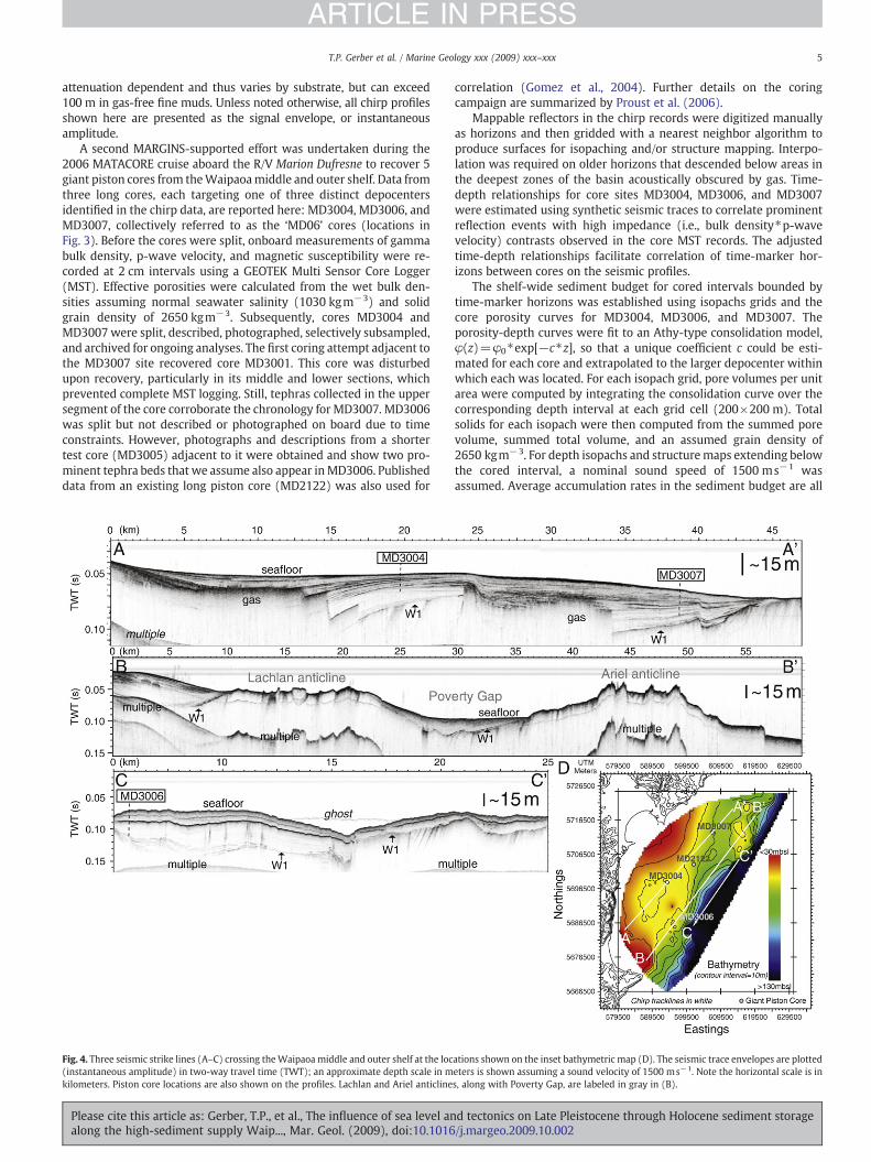
Fig. 4. Three seismic strike lines (A–C) crossing theWaipaoamiddle and outer shelf at the loc(instantaneous amplitude) in two-way travel time (TWT); an approximate depth scale in mkilometers. Piston core locations are also shown on the profiles. Lachlan and Ariel anticline
Please cite this article as: Gerber, T.P., et al., The influence of sea level analong the high-sediment supply Waip..., Mar. Geol. (2009), doi:10.1016
correlation (Gomez et al., 2004). Further details on the coringcampaign are summarized by Proust et al. (2006).
Mappable reflectors in the chirp records were digitized manuallyas horizons and then gridded with a nearest neighbor algorithm toproduce surfaces for isopaching and/or structure mapping. Interpo-lation was required on older horizons that descended below areas inthe deepest zones of the basin acoustically obscured by gas. Time-depth relationships for core sites MD3004, MD3006, and MD3007were estimated using synthetic seismic traces to correlate prominentreflection events with high impedance (i.e., bulk density⁎p-wavevelocity) contrasts observed in the core MST records. The adjustedtime-depth relationships facilitate correlation of time-marker hor-izons between cores on the seismic profiles.
The shelf-wide sediment budget for cored intervals bounded bytime-marker horizons was established using isopachs grids and thecore porosity curves for MD3004, MD3006, and MD3007. Theporosity-depth curves were fit to an Athy-type consolidation model,φ(z)=φ0⁎exp[−c⁎z], so that a unique coefficient c could be esti-mated for each core and extrapolated to the larger depocenter withinwhich each was located. For each isopach grid, pore volumes per unitarea were computed by integrating the consolidation curve over thecorresponding depth interval at each grid cell (200×200 m). Totalsolids for each isopach were then computed from the summed porevolume, summed total volume, and an assumed grain density of2650 kgm−3. For depth isopachs and structuremaps extending belowthe cored interval, a nominal sound speed of 1500 ms−1 wasassumed. Average accumulation rates in the sediment budget are all
ations shown on the inset bathymetric map (D). The seismic trace envelopes are plottedeters is shown assuming a sound velocity of 1500 ms−1. Note the horizontal scale is ins, along with Poverty Gap, are labeled in gray in (B).
d tectonics on Late Pleistocene through Holocene sediment storage/j.margeo.2009.10.002

6 T.P. Gerber et al. / Marine Geology xxx (2009) xxx–xxx
ARTICLE IN PRESS
reported with a fixed, 10% uncertainty to account for several potentialsources of error that are not quantifiable.
4. Waipaoa shelf stratigraphy
4.1. Overview of Late Pleistocene and Holocene seismic architecture
Interpreting a limited set of 3.5 kHz profiles crossing the Waipaoamargin, Foster and Carter (1997) identified distinct middle and outershelf modern depocenters above the first prominent unconformity inthe subsurface, which they interpreted as an erosion surface asso-ciated with the last sea level lowstand. Following Lewis (1973), whomade the same interpretation of shelf strata south of Hawke's Bay(NZ), they labeled this horizon “W1”, a convention we adopt here. Inthis section we describe the structure of W1 and the overlying sed-imentary architecture using our newly acquired chirp records, beforeproceeding in Section 5 to develop a sequence-stratigraphic inter-pretation for the shelf strata.
The character of W1 and the strata above it are seen in three chirplines that parallel the coast (Fig. 4A–C). In each, the W1 unconformityis defined by the loss of acoustic penetration into lower strata and isangular in sections where tilted bedding planes are observed beneathit. The two mid-shelf depocenters above W1 are separated by anemergent structure draped with thin syntectonic strata. Apparentuplift along this structure and the Mahia coast south of Poverty Bay
Fig. 5. (Top) Structure map of the W1 surface in perspective view, with the onshore digital ealong with the transect shown in bottom panel. (Bottom) Figure redrawn from Berryman (coast of Mahia Peninsula. Note maximum uplift of ∼4500 yr terrace is ∼15 m.
Please cite this article as: Gerber, T.P., et al., The influence of sea level analong the high-sediment supply Waip..., Mar. Geol. (2009), doi:10.1016
define the syncline that contains a southern depocenter (Fig. 4A).Numerous reflectors there dip into a basin deep where gas obscuresthe W1 surface. Gas is also present at depth in a northern depocenter,but reflectors there are more parallel and converge northward onto asecond emergent structure that exposes W1 at the seafloor.
Lewis and Pettinga (1993) and Foster and Carter (1997) identifiedthese structures, Ariel (north) and Lachlan (south), as emergentanticlinal folds with cores of Miocene slope mudstone that mark thefront of accretionary slope deformation. A chirp line parallel to butseaward of Fig. 4A crosses the crests of the two anticlines and ter-minates to the southwest on the uplifted Mahia coast (Fig. 4B). Theanticlines are separated by a ∼10 km offset known as Poverty Gap(Foster and Carter, 1997), where a thin, acoustically transparent unitdrapes W1. A third line seaward of the anticline crests shows that thestructural offset between them is partially accommodated along afault visible seaward of the Lachlan structure. Strata in a thirdsubbasin, described on 3.5 kHz profiles by Orpin et al. (2006), thickenacross the hanging wall of this fault and extend to the northern rim ofLachlan canyon. The depocenter above W1 is relatively thick there,and is acoustically transparent except for two prominent, drapingreflectors.
The structural configuration of the shelf is shown in Fig. 5 witha map of the W1 surface and in Fig. 6 with an isopach of the strataabove it. Across the shelf, the thickness of overlying basin fill mirrorsthe deformation of W1, which shows greater negative relief in the
levation model (DEM) included. Major structural features discussed in text are labeled,1993a,b) showing westward tilt of uplifted Holocene marine terraces on the northern
d tectonics on Late Pleistocene through Holocene sediment storage/j.margeo.2009.10.002

Fig. 6. Isopach map showing sediment thickness between W1 and the seafloor across the Waipaoa shelf assuming a velocity of 1500 ms−1. Structure contours on the W1 surface(mbsl) are overlain on the map (contour interval is 15 m).
7T.P. Gerber et al. / Marine Geology xxx (2009) xxx–xxx
ARTICLE IN PRESS
southern mid-shelf relative to the northern mid-shelf. A saddlebetween the plunging tip of the Lachlan anticline and the upliftingcoast east of Poverty Bay separates the mid-shelf depocenters. Thenorthern depocenter thins through Poverty Gap but thickens again asit connects to the outer shelf depocenter. Dashed extensions (Fig. 5)on the southern syncline axis denote our inference of structuralcontinuity between the basin, Mahia syncline (Berryman, 1993a,b),and subsidence beneath Poverty Bay Flats (Brown, 1995). Evidence oftectonic tilting in well logs beneath Poverty Flats (see Wolinsky et al.,this issue) and uplifted shoreline terraces above the northern coast ofMahia Peninsula (Fig. 5) reveals the onshore extension ofdeformation.
Maximum sediment thickness in the southern depocenter(∼70 m) is considerably higher than on the northern (∼45 m) andouter shelf (∼55 m). It is worth noting here that the southern isopachis appreciably thicker than that mapped by Foster and Carter (1997)and Orpin et al. (2006). The disagreement is due to the fact that theytraced W1 into the southern depocenter on a horizon in the 3.5 kHzprofiles that corresponds to what we interpret as a shallower, Holo-cene reflector in our chirp records.
4.2. Post-W1 chronostratigraphy: core-seismic integration
In this section we integrate three giant piston cores – two re-covered from the mid-shelf depocenters and a third from the outershelf – with the chirp data to establish a chronostratigraphy for thepost-glacial sediment record on theWaipaoa shelf (Figs. 7–9). Our agemodel is based primarily on the identification of three geochemicallydistinct tephras. The ashes were ejected during volcanic eruptions inthe North Island's Taupo Volcanic Zone (TVZ). Ages for the tephrashave been established from widely observed terrestrial deposits (see
Please cite this article as: Gerber, T.P., et al., The influence of sea level analong the high-sediment supply Waip..., Mar. Geol. (2009), doi:10.1016
Alloway et al., 2007, for dates reported here and additional back-ground on NZ tephrochronology). We interpret the ash beds asprimary airfall tephras that settled through the water column, de-posited, and in some cases were reworked. Supporting this view arecorrected 14C dates from shells above and below the tephras in each ofthe cores. Though not presented here (see Alexander et al., manu-script in preparation), the dates are consistent with ages for thetephras based on their terrestrial occurrence. The three tephras con-veniently subdivide the early eustatic highstand period (∼5500 cal.yrBP to present) into three approximately equal time intervals. Tomark the late eustatic rise, we report the depth of the Pleistocene–Holocene boundary (∼10000 cal.yrBP) in each core predicted by the14C age model.
To link the tephra and 14C markers in core (depth) with mappableseismic horizons in the chirp profiles (two-way travel time), we useMST logs to establish time-depth relationships for the core intervals ateach site. Results for the two mid-shelf cores are summarized inFig. 8A and B, where physical property logs for MD3004 (southerndepocenter) andMD3007 (northern depocenter) are shown. Includedin each log panel is the synthetic seismic trace predicted from the coreimpedance log that was used to tie core depths to the seismic two-way travel times. Each synthetic trace is overlain on the seismic data(Fig. 7B and D). Both synthetic traces are stretched in two-way traveltime to produce the best possible match to the field records. Inother words, the two-way travel times predicted from measured(MST) p-wave velocities and core depths appear to underestimate theactual two-way travel times over the cored interval. There are twopotential sources for the discrepancy: (1) anomalously high p-wavemeasurements on the cores, or (2) shortening of the piston coresduring extraction that caused measured thickness to be less than insitu thickness. Since the measured p-wave velocities are not
d tectonics on Late Pleistocene through Holocene sediment storage/j.margeo.2009.10.002

Fig. 7. A) Interpreted middle segment of seismic strike line shown in Fig. 4A. Marker horizons are discussed in text and defined in the log panels of Fig. 8. Core sites MD3004 andMD3007 are also shown; boxes enclose traces shown in parts B and D. The MD2122 core site lies 2.25 km seaward from this line (shown in part C), so its projection is shown here.B) Synthetic chirp trace overlain on trace amplitudes recorded at the MD3004 core site. Synthetic trace produced using the physical property logs in Fig. 8A. C) Chirp seismic traceenvelopes crossing the site of core MD2122 (see Gomez et al., 2004). Tephra marker horizons mapped across the site are shown along with the inferred depth of the Tuhua marker,which was not sampled in theMD06 cores. Terminology for the sequence-stratigraphic interpretation follows Fig. 1. D) Synthetic chirp trace overlain on trace amplitudes recorded atthe MD3007 core site. Synthetic trace produced using the physical property logs in Fig. 8B.
8 T.P. Gerber et al. / Marine Geology xxx (2009) xxx–xxx
ARTICLE IN PRESS
unreasonable for fine, unconsolidatedmarinemuds (Hamilton, 1971),we believe the latter effect is dominant. Assuming this, an averageshortening of 6.5% and 7.1% of the in situ thickness for MD3004 andMD3007, respectively, can account for the mismatch we identify.
A similar correlation plot for the outer shelf core (MD3006) is shownin Fig. 9. The synthetic trace for this core is also adjusted to providesatisfactory agreement with the chirp data, but in this case a matchrequired both stretching and compression in two-way travel time. Againassuming measured (MST) p-wave velocities are accurate, an averagelengthening of 3.3% of the in situ thickness accounts for the mismatch.We note that a similar analysis reported by Széréméta et al. (2004)showed both types of sampling anomaly seen in other giant piston corescollected aboard the R/V Marion Dufresne. As in their study, neitherstretching nor compression anomalies were obvious from visualinspection of the cores. The issue concerns us only insofar as it must beaccounted for in our core-to-core correlation and sediment isopaching.
Accepting this, we highlight our tephra-bound chronology for themid- and outer shelf in Figs. 7–9. The most prominent ash bed in all
Please cite this article as: Gerber, T.P., et al., The influence of sea level analong the high-sediment supply Waip..., Mar. Geol. (2009), doi:10.1016
three cores is identified with the Waimihia eruption (Waimihiatephra; 3410 cal.yrBP) from the Taupo caldera (TVZ). This tephra,widely recognized in terrestrial and marine records around the NorthIsland, is 15–20 cm thick in MD3004 and MD3006 (Fig. 10A–B) butless well-preserved in MD3007 (Fig. 10C). Another, younger tephra(Taupo tephra; 1718 cal.yrBP) widely sampled and correlated acrossNorth Island terrestrial and marine records is preserved in MD3006,but apparent bioturbation in mid-shelf cores makes its visual iden-tification difficult. For this reason, the Taupo tephra marker is tied inMD3004 and MD3007 to the base of peaks in magnetic susceptibilitythat we interpret as the primary occurrence of the tephra. Recoveryand identification of Taupo tephra at 2.3 m depth in MD3001 –
collected just adjacent to MD3007 – corroborate this interpretation, asdo 14C dates in each of the cores. Both theWaimihia and Taupo tephrahorizons coincide with reflectors that can be traced between andbeyond MD3004 and MD3007 (Fig. 7A), but the correspondingreflectors on the outer shelf (Fig. 9A) tied to the same markerhorizons in MD3006 cannot be traced through Poverty Gap.
d tectonics on Late Pleistocene through Holocene sediment storage/j.margeo.2009.10.002
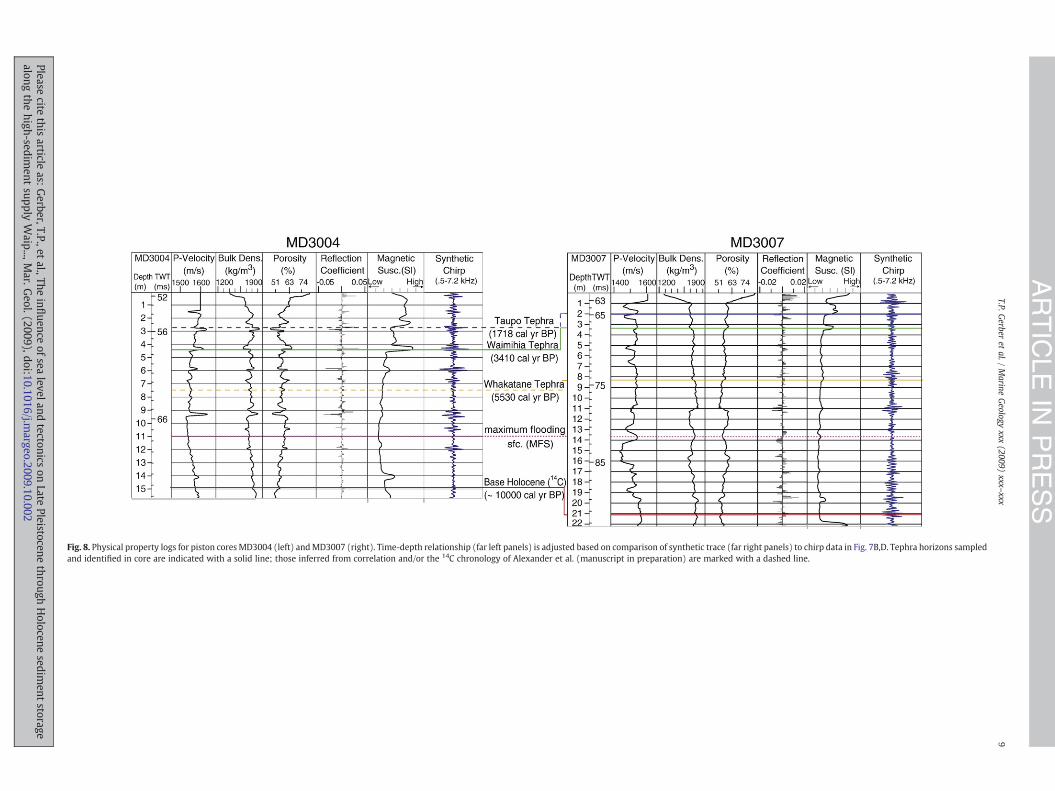
Fig. 8. Physical property logs for piston cores MD3004 (left) andMD3007 (right). Time-depth relationship (far left panels) is adjusted based on comparison of synthetic trace (far right panels) to chirp data in Fig. 7B,D. Tephra horizons sampledand identified in core are indicated with a solid line; those inferred from correlation and/or the 14C chronology of Alexander et al. (manuscript in preparation) are marked with a dashed line.
9T.P.G
erberet
al./Marine
Geology
xxx(2009)
xxx–xxx
ARTICLE
INPRESS
Pleasecite
thisarticle
as:Gerber,T.P.,et
al.,Theinfluence
ofsealeveland
tectonicson
LatePleistocene
throughHolocene
sediment
storagealong
thehigh-sedim
entsupply
Waip...,M
ar.Geol.(2009),doi:10.1016/j.m
argeo.2009.10.002

10 T.P. Gerber et al. / Marine Geology xxx (2009) xxx–xxx
ARTICLE IN PRESS
Please cite this article as: Gerber, T.P., et al., The influence of sea level and tectonics on Late Pleistocene through Holocene sediment storagealong the high-sediment supply Waip..., Mar. Geol. (2009), doi:10.1016/j.margeo.2009.10.002

Fig. 10. Example photographs of macroscopic Waimihia tephra recovered in (A) MD3004, (B) MD3007, and (C) MD3006.
11T.P. Gerber et al. / Marine Geology xxx (2009) xxx–xxx
ARTICLE IN PRESS
A third Holocene tephra in MD3007 is identified with the Whaka-tane eruption (Whakatane tephra; 5530 cal.yrBP) from the Okatainacaldera (TVZ). Like the Taupo tephra it also appears bioturbated in thecore, but unlike both of the younger tephras it does not show elevatedmagnetic susceptibility and has only a modest effect on theimpedance log. Whakatane tephra has not been identified in coresMD3004 and MD3006 but both contain shells of similar age. TheWhakatane marker horizon is extended away from MD3007 andMD3004 by tracing a semi-continuous reflector across the mid-shelf.Because the seismic character is transparent at the Whakatane depthon the outer shelf, the marker is mapped away from the core bysimply paralleling the draped geometry of overlying reflectors.
The Whakatane, Waimihia, and Taupo tephra markers were allidentified in a previous core (MD2122) first described by Gomez et al.(2004). The site of this core is covered by the chirp survey and shownin Fig. 7C. The three marker horizons traced away from theMD06 coresites are shown on the plot. Combining two-way travel times for eachhorizon at the MD2122 site with the core depths for each tephramarker reported by Gomez et al. (2004) implies low apparent velo-cities, which may also indicate shortening of the piston core uponrecovery. As we show in Section 6, our computed mass accumulationrates for the MD2122 site based on the correlation in Fig. 7C are inreasonable agreement with measurements made directly on the coreby Gomez et al. (2007). Given this, we forego further inquiry andsimply note that the apparent shortening is not inconsistent withour analysis of the MD06 cores. Note on Fig. 7C we have alsoapproximated the location of a fourth tephra marker (Tuhua tephra,7005 cal.yrBP) identified inMD2122 but not yet sampled in theMD06cores.
Fig. 9. A) Interpretedmiddle segment of seismic strike line shown in Fig. 4C. Marker horizonstraces shown in Part B. B) Synthetic chirp trace overlain on trace envelopes recorded at theC) Physical property logs for piston core MD3006. Time-depth relationship (far left panel) isTephra horizons sampled and identified in core are indicated with a solid line; those infpreparation) are marked with a dashed line.
Please cite this article as: Gerber, T.P., et al., The influence of sea level analong the high-sediment supply Waip..., Mar. Geol. (2009), doi:10.1016
The 14C age model indicates that all three piston cores stopped justbelow the Pleistocene–Holocene boundary (Figs. 7–9). Thus each corecontains a full Holocene record and, importantly, a record of risingeustasy along the New Zealand coastline. In the following section weuse this finding to develop our sequence-stratigraphic model for thepost-glacial flooding of the Waipaoa shelf.
5. Sequence-stratigraphic interpretation
Together, the W1 surface and the four marker horizons definedabove provide a chronostratigraphic framework for interpreting theLate Pleistocene and Holocene evolution of the Waipaoa shelf. In thissection we combine that framework with sequence-stratigraphicprinciples to interpret key surfaces and stratal patterns associatedwith changes in accommodation during the last glacioeustatic rise andongoing tectonic deformation. Standard sequence-stratigraphic ter-minology is used and follows Fig. 1 (see caption).
5.1. Late lowstand and transgressive strata: W1 and the shelf floodingsurface
The eustatic sea level fall and subsequent rise that accompaniedthe last glacial advance and retreat strongly influenced LatePleistocene and Holocene accommodation on the Waipaoa margin.Global sea level fell 120 m below its present level between ∼120,000and ∼20,000 cal.yrBP (Pillans et al., 1998; Fig. 11A). Eustatic sea levelsubsequently rose with deglaciation, reaching its present level alongthe coast of New Zealand around 7000 cal.yrBP (Gibb, 1986; Fig. 11B).The rapid increase in accommodation during this period forced a
are discussed in text and defined in Part C. Core site MD3006 is also shown; box enclosesMD3006 core site. Terminology for sequence-stratigraphic interpretation follows Fig. 7.adjusted based on comparison of synthetic trace (far right panel) to chirp data in Part B.erred from correlation and/or the 14C chronology of Alexander et al. (manuscript in
d tectonics on Late Pleistocene through Holocene sediment storage/j.margeo.2009.10.002

Fig. 11. A) Representative global eustatic curve following Pillans et al. (1998) and Slingerland et al. (2007) with approximate age range for Late Pleistocene tephras recovered inMD3004 and MD3007 included. B) Holocene eustatic curve for New Zealand based on Gibb's reconstruction (1986) and reproduced from Cochran et al. (2006). Included are ages ofHolocene tephras discussed in text. C) Mapped paleo-shorelines beneath Poverty Flats from Brown (1995).
12 T.P. Gerber et al. / Marine Geology xxx (2009) xxx–xxx
ARTICLE IN PRESS
Please cite this article as: Gerber, T.P., et al., The influence of sea level and tectonics on Late Pleistocene through Holocene sediment storagealong the high-sediment supply Waip..., Mar. Geol. (2009), doi:10.1016/j.margeo.2009.10.002

13T.P. Gerber et al. / Marine Geology xxx (2009) xxx–xxx
ARTICLE IN PRESS
shoreline transgression across the margin, the latter stages of whichare recorded landward of the shelf by paleo-shorelines beneath themodern coastal plain of the Waipaoa River (Poverty Flats, Fig. 11C).
We interpret the W1 unconformity as a sequence boundary (SB)associated with the last sea level fall and consequent shorelineregression. Where visible on the mid-shelf, W1 cuts into a deformed,consolidated substrate and is traceable onto the exposed cores of theanticlines (Fig. 4A; Fig. 7). None of the piston cores penetrated theburied extension of W1, but where exposed on the uplifted northernflank of the Lachlan structure the surface was mantled with gravelsinterpreted as lowstand deposits of the Waipaoa River (Wood, 2006).In places, diffuse reflections on W1 may indicate the presence of thinlowstand gravels (Fig. 7C), but the chirp records show no prominentincised valley, suggesting limited fluvial incision into the exposedshelf as the shoreline moved seaward.
On the outer shelf, W1 defines a wave-planed terrace on theseaward flank of the Ariel anticline that we interpret to be the lastlowstand shoreline (Fig. 12A–B). A strong angular unconformitydraped with post-glacial mud (transparent acoustic facies) delineatesthe terrace, which extends parallel to the anticline's crest and themodern coastline.W1 shows similar character alongmost of the outershelf except where it extends beneath the depocenter lying just northof Lachlan canyon (Fig. 4C; Fig. 9), where the sequence boundaryunderlies a package of parallel and truncated reflectors that thickentowards the canyon head. There, W1 diverges from a separate un-conformity that marks the boundary between the truncated unitand the overlying transparent seismic facies (gray dashed line inFig. 9A–B).
Two primary seismic facies are above W1 near MD3004 andMD3007 (Figs. 4A; 7A,C). An acoustically transparent facies with a fewweak, discontinuous reflectors characterizes the older unit, which isoverlain by a highly reflective package containingmultiple continuousreflectors. The facies break corresponds to a downlap surface for theoldest reflectors in the overlying unit. In the cores, the break cor-responds to a depth 5–7 m above the Pleistocene–Holocene boundary.At site MD2122, the break is near the inferred travel-time depth forthe Tuhua tephra (∼7000 cal.yrBP).
Unlike the mid-shelf, no distinct acoustic facies break divides theouter shelf depocenter above W1 except for the unit adjacent to
Fig. 12. A) Shore-perpendicular seismic line across the northern subbasin and the Ariel anticpanel is two-way travel time with approximate depth scale in meters assuming a sound velocouter shelf seaward of Ariel anticline. Location of both lines is indicated on the bathymetric mthe depth of the Chirp hydrophones in TWT.
Please cite this article as: Gerber, T.P., et al., The influence of sea level analong the high-sediment supply Waip..., Mar. Geol. (2009), doi:10.1016
Lachlan canyon (Fig. 9). The MD3006 core stopped in this unit, andvisual descriptions of the core indicate sands in its base. The 14C agemodel for MD3006 indicates the contact is at or near the Pleistocene–Holocene boundary.
Taken together, the seismic and core evidence support thefollowing sequence-stratigraphic interpretation. The mid-shelf faciesboundary described above is a maximum flooding surface (MFS) thatformed as the transgressing Waipaoa shoreline reached its maximuminland extent. As seen in Fig. 11C, the age of the most landward paleo-shoreline mapped in Poverty Bay matches that estimated for theculmination of eustatic sea level rise (∼7000 cal.yrBP) and the Tuhuatephra marker identified in MD2122, which lies at or near ourplacement of the MFS (Fig. 7). The seismic downlap of overlyingreflectors – a diagnostic attribute of shelf flooding surfaces – marksthe onset of coastal progradation in Poverty Bay and highstand sed-iment delivery to the shelf. The latter is further evidenced by acoarsening upward trend seen in grain size measurements fromMD2122 above our placement of the MFS (Gomez et al., 2004). Onthe outer shelf the MFS is not resolvable, but we infer its presencewithin the 5–6 m condensed section (i.e., an interval of low ac-cumulation rates) between the base of the core and the Whakatanemarker horizon (Fig. 9).
Extending our sequence-stratigraphic approach (i.e., Fig. 1), weexpect a mid-shelf succession below the MFS and above W1 con-sisting of late lowstand to early transgressive paralic strata capped bya transgressive wave ravinement surface (TS) and overlain by acondensed section of late transgressive and early highstand strata. Onthe outer shelf near the lowstand shoreline, we expect to observe aravinement surface cutting either lowstand deltaic deposits or thesequence boundary (W1) and capped by thin, hemipelagic drape. Thetruncated outer shelf unit adjacent to Lachlan canyon may in fact be adeltaic unit associated with the lowstandWaipaoa (Fig. 9), and whereW1 is overlain directly by thin transparent facies there is neither awell-developed transgressive surface nor overlying transgressive de-posits (e.g., Fig. 12B).
Characterizing facies beneath the MFS in the mid-shelf depocen-ters is more difficult, especially given the lack of detailed textural andpaleoenvironmental indicators. The interval lying between the MFSand W1 is approximately 15 m thick near the core sites and even
line. Labels in this figure and Part B refer to discussion in text, and vertical scale in eachity of 1500 ms−1. Intersection with line in Part B is marked. B) Shore-parallel line alongap in Part C. Note that projection of LGM sea level in Parts A and B includes correction for
d tectonics on Late Pleistocene through Holocene sediment storage/j.margeo.2009.10.002

14 T.P. Gerber et al. / Marine Geology xxx (2009) xxx–xxx
ARTICLE IN PRESS
thicker in the basin deeps. Foster and Carter (1997) and Orpin et al.(2006) interpreted W1 as the TS, which implies that the intervalbelow the base of the mid-shelf cores was deposited seaward of atransgressing shoreline prior to ∼10000 cal.yrBP. This is consistentwith the lack of a mappable seismic discontinuity above W1 thatwould indicate a separate overlying TS. Together, their interpretationand previous estimates for the marine incursion of Poverty Bay(10,000–11,000 cal.yrBP, Fig. 10C; Brown, 1995) suggest a relativelythick, well-preserved transgressive unit on the Waipaoa mid-shelf.
Given this, we interpret the TS to lie directly on the SB (W1) acrossmost of the Waipaoa shelf. Evidence for Late Pleistocene lowstanddeposits appears to be largely absent, except for the outer shelf unitnoted above (Fig. 9) and a package directly overlying W1 landward ofAriel anticline (Figs. 12A; 14A). Without additional evidence from thedeposits beneath the cored interval we are unable to develop themodel further. At present, it is unclear when – in terms of eustasy andthe position of the paleo-shoreline – erosion on W1 ceased andsediments began accumulating, and whether the deposits areprimarily nearshore, estuarine, or inner-shelf facies is not addressedhere.
Nevertheless, it is worth remembering that like most sequenceboundaries, W1 is a diachronous surface formed during shorelinemigration. Where imaged clearly, W1 apparently cuts not into shelfsediments of the previous highstand but older, deformed rocks of theaccretionary prism. This suggests that in addition to recordingtransgressive wave ravinement during the last eustatic rise W1 mayalso bear the signature of multiple sea level lowstands. Implicit in thisview is that previous sequences of lowstand, transgressive, andhighstand deposits may be confined to the gas-obscured basin deeps.And as we show in Section 5.2 (see alsoWood, 2006), W1 also recordshighstand ravinement where it shoals to depths at or above modernfair-weather wave base on the anticline crests.
In summary, seismic and core data support the identification of aflooding surface (MFS) across the Waipaoa shelf that is of similar ageto the most landward mapped shoreline in Poverty Bay and regionalestimates for the culmination of the post-glacial eustatic rise. If thetransgressive surface (TS) lies directly on the sequence boundary(W1) across most of the mid-shelf, then a relatively thick transgres-sive unit is preserved but few lowstand deposits. In this case, stratadirectly overlying W1 in the subsiding shelf basins formed during theend of falling or minimum eustasy (as in the generic sequence inFig. 1). More detailed sedimentological data should resolve the natureof deposition immediately beneath the MFS.
5.2. The modern highstand: tectonic controls on accommodation
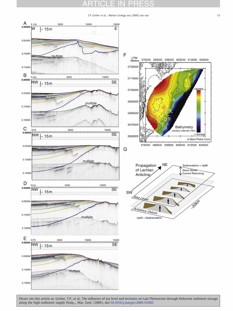
In this section we consider in more detail highstand strata abovethe MFS. In the present eustatic stillstand that began 7000 cal.yrBP,the dominant control on highstand accommodation is the ongoingtectonic deformation across the shelf. In Section 4.1 we contrastedstratal geometry and character between the two mid-shelf (Fig. 4A)and outer shelf (Fig. 4C) subbasins, noting differences across the mid-shelf that are even expressed in the seafloor bathymetry (Fig. 4D).Reflectors in the southern depocenter define an underfilled syncline,where the subsidence pattern evident in the post-W1 isopach ismirrored at the seafloor. In contrast, the stratal geometry of thenorthern depocenter shows a more progradational pattern alongstrike, and the highstand prism resembles a low gradient clinoform indip profile (Fig. 12A). Spatial and temporal variation in the mid-shelfsubsidence pattern can give rise to such differences, but mapping outthe detailed structural evolution of the shelf is beyond the limits of theshallow chirp and core data presented here. Yet a closer look at stratal
Fig. 13. (A–E). Series of seismic transects crossing the landward flank of Lachlan anticline atime; an approximate depth scale in meters is shown assuming a sound velocity of 1500 msketch explaining the pattern of stratal termination patterns along the landward flank of La
Please cite this article as: Gerber, T.P., et al., The influence of sea level analong the high-sediment supply Waip..., Mar. Geol. (2009), doi:10.1016
patterns in the early highstand growth strata provides clues to theongoing tectonic modulation of shelf infilling.
We infer the uplift and subsidence history of the Lachlan anticlineand southern syncline, respectively, from the termination patterns ofhighstand marker horizons along the Lachlan structure. A series ofchirp transects in Fig. 13 covering the transition from syncline toanticline flank shows a systematic pattern moving south to northalong the crest of the structure. The southernmost line, just offshorefrom Mahia Peninsula, shows an upturned package of post-W1 stratawith apparent truncation of the oldest highstand marker horizons(Fig. 13E). Moving north, apparent truncation of the growth stratagivesway to seismic offlapwith an increasing degree of seismic pinch-out (Fig. 13D–C). Further north, the same unit progressively onlapsonto the uplifting anticline (Fig. 13B) and, at the northernmostcrossing, is seen to completely drape the tip of the structure (Fig. 13A).Note the depth of the anticline crest varies little between transects.
If wave and current reworking of the seabed depend primarily onwater depth, then the preservation potential for sediments depositedacross a growing fold should depend on its uplift history during basinfilling. We therefore interpret the pattern seen in Fig. 13A–E to resultfrom a decrease in uplift relative to sediment accumulation fromsouth to north along the Lachlan structure that probably reflects itsnorthward propagation into the Waipaoa margin (Fig. 13G). Whereuplift is greatest in the south – that is, from high rates of upliftsustained for longer – early highstand growth strata have shoaled todepths where wave and current reworking (i.e., ravinement) canoccur (Fig. 13E). Where uplift is reduced in the north, highstandmarker horizons define a growth package that tapers toward the foldcrest and shows an increasing degree of onlap to the north, suggestingan increase in sedimentation rates relative to uplift (Fig. 13C–B). Atthe propagating tip of the fold, sedimentation still exceeds uplift andcompletely buries the emerging structure and the W1 surface. In ageneral sense, our model for the spatial gradient in stratal geometryalong the Lachlan structure (i.e., Fig. 13G) can be thought to ap-proximate the time-evolution along any given transect as the foldpropagates northward.
Seismic transects crossing the Ariel anticline do not show a strongmargin-parallel gradient in uplift. Yet variations in onlap–offlapgeometry in the growth strata along a single transect suggest tem-poral variation in the accommodation–supply balance across theevolving northern basin (Figs. 12; 14). Early highstand strata onlaponto the emergent Ariel fold, but the termination pattern reversesabove the Whakatane marker horizon such that the youngest unit,containing the Waimihia and Taupo markers, shows slight seismicofflap. Evidently, sediments began filling new accommodation duringthe early highstand period, marked by onlap of the anticline flankcoincident with downlap in subsiding shelf reaches. With sea levelstabilized, filling of this space and continued uplift on the anticline haslimited overall storage in the basin and caused distal strata to offlap theflank. In other words, accommodation in the northern basin may nowbe filled, with progradation limited by the emergence of the outershelf. Implicit in this view is that sediments delivered to the northernmid-shelf have increasingly been stored elsewhere, perhaps on theouter shelf, an idea we consider further in the following section.
6. Holocene highstand sediment budget
In this section we quantify the early highstand sediment budget tofurther evaluate the accommodation–supply balance in each shelfsubbasin and constrain the shelf-wide storage of terrestrial sediment.The budget (5530 cal.yrBP to present) is summarized in Figs. 15 and 16.In Fig. 15A–C, we plot three maps showing the spatial variation in
long the boundary of the southern mid-shelf subbasin. Vertical scale is two-way travels−1. Locations of lines are shown on the small bathymetric map in Part F. G) Conceptchlan anticline.
d tectonics on Late Pleistocene through Holocene sediment storage/j.margeo.2009.10.002
15T.P. Gerber et al. / Marine Geology xxx (2009) xxx–xxx
ARTICLE IN PRESS
Please cite this article as: Gerber, T.P., et al., The influence of sea level and tectonics on Late Pleistocene through Holocene sediment storagealong the high-sediment supply Waip..., Mar. Geol. (2009), doi:10.1016/j.margeo.2009.10.002

Fig. 14. A) Close up of seismic amplitudes from Fig. 12A where strata pinch-out on the flank of Ariel anticline. B) Concept sketch depicting filling of northern subbasin. Perspectivemaps of bathymetry (from Fig. 3) and W1 (from Fig. 5) look east towards the Waipaoa River mouth (both in mbsl).
16 T.P. Gerber et al. / Marine Geology xxx (2009) xxx–xxx
ARTICLE IN PRESS
average mass accumulation rate (MAR, gcm−2yr−1) between eachinterval bounded by the three highstandmarker horizons introduced inSection 4.2. In Fig. 16A and B, we plot the total average storage rate(Mtyr−1) and relative average storage rate (% of total shelf storage) foreach interval in the threemain shelf depocenters outlined in Section 4.1and evident in the accumulation ratemaps. In Fig. 16C, the total averagestorage rate (Mtyr−1) for the entire shelf is plotted with three ad-ditional estimates for comparison: (1) themeanand range of suspendedsediment loads delivered to Poverty Bay by the Waipaoa River from3000 to 700 cal.yrBP estimated by Kettner et al. (2007), (2) themodern(gauged) annual suspended sediment output to Poverty Bay (Hickset al., 1999), and (3) an estimate for the total annual rate of accumu-lation based on 210Pb chronology (last ∼100 yr) reported by Miller andKuehl (this volume). Finally, the inset to Fig. 16C compares our esti-mated mass accumulation rates at the MD2122 site (i.e., Fig. 15B–C) tothe core-derived estimates reported by Gomez et al. (2007).
6.1. Spatial and temporal trends in highstand shelf accumulation
Several features of our highstand sediment budget stand out.Overall, total shelf storage declines slightly from the mid-Holocene to
Please cite this article as: Gerber, T.P., et al., The influence of sea level analong the high-sediment supply Waip..., Mar. Geol. (2009), doi:10.1016
the present. The difference is small and may not be significant giventhe uncertainties in our summation. If real, the result suggests either asmall increase in sediment export from the shelf and/or a smalldecline in the supply of sediment to the shelf. But a more importantresult emerges when our loads are compared to the estimates ofKettner et al. (2007). Their running mean (=2.3Mtyr−1) for the lateHolocene prior to human settlement (∼700 cal.yrBP) comparesfavorably to our budget, suggesting that our storage estimates accountfor most or all of the suspended sediment delivered by the WaipaoaRiver to the coast during most of the early highstand period. In otherwords, our best estimate suggests a high shelf trapping efficiency forterrestrial sediment during this period.
The MAR maps and depocenter budget numbers quantify thepartitioning of the Waipaoa's highstand load into distinct subbasins.The southern mid-shelf basin is the primary depocenter, containing60–65% of the total highstand load. The small Holocene decline thereis thus the dominant influence on the trend noted above for the totalshelf. Storage on the outer shelf is much smaller but also shows aslight Holocene decline. Storage in the northern mid-shelf is morevariable, dropping nearly 50% between the oldest two intervals to anaverage load less than that of the outer shelf. Storage then increases
d tectonics on Late Pleistocene through Holocene sediment storage/j.margeo.2009.10.002

Fig. 15. (A–C) Mass accumulation rate maps for cored intervals bounded by the highstand tephra markers discussed in the text. Contours (15 m interval) are on W1.
17T.P. Gerber et al. / Marine Geology xxx (2009) xxx–xxx
ARTICLE IN PRESS
Please cite this article as: Gerber, T.P., et al., The influence of sea level and tectonics on Late Pleistocene through Holocene sediment storagealong the high-sediment supply Waip..., Mar. Geol. (2009), doi:10.1016/j.margeo.2009.10.002

Fig. 16. A) Total load (Mtyr−1) averaged over the three time intervals shown in Fig. 13 for each shelf depocenter. A constant, ±10% uncertainty is assigned to the load estimates.B) Same as Part A, but now loads are expressed as a fraction of the total shelf storage (from Part C) for each time interval. C) Total shelf loads for each time interval, expressed againwith a±10% uncertainty. Also shown are: themean (2.3 Mtyr−1) and range (shown as error bars) of Kettner et al.'s predictions for suspended sediment output from 3000 to 700 cal.yrBP, the 19th–20th century loads estimated by Miller and Kuehl in this volume (3.75 Mtyr−1), and the modern (gauged) suspended sediment discharge at the coast. (Inset) Massaccumulation rates estimated at the MD2122 site from our seismic mapping and extrapolation of MD06 piston core data. Our average MARs for the two most recent intervals(Fig. 13B–C) are compared with the higher resolution MARs measured directly on the core by Gomez et al. (2007).
18 T.P. Gerber et al. / Marine Geology xxx (2009) xxx–xxx
ARTICLE IN PRESS
by a smaller amount in the most recent interval. Note in the plot ofrelative depocenter loads that the large decrease in northern mid-shelf storage is accompanied by an increase in the percentage of totalstorage within the southern mid-shelf and outer shelf basins.
Together with our findings from Section 5.2, the maps and cumu-lative sediment budget for the Waipaoa shelf support a characteriza-tion of the shelf depocenters in terms of the supply–accommodationbalance. The underfilled geometry of the southernmid-shelf basin andits large fraction of total sediment storage through the early highstandsuggest accommodation-dominated conditions, an idea first put for-ward by Orpin et al. (2006). In this view, long-term sediment supply isless than the accommodation produced by tectonic subsidence andthus sediment storage is high. Conversely, the stratal geometryobserved in the northern mid-shelf basin in combination with thelarge reduction in sediment storage there suggests supply-dominatedconditions. In this view, accommodation produced by tectonicsubsidence is less than long-term sediment supply and thus limitssediment storage. A shift to overfilled conditions during the highstandlimited storage of sediment delivered to the northern mid-shelf,
Please cite this article as: Gerber, T.P., et al., The influence of sea level analong the high-sediment supply Waip..., Mar. Geol. (2009), doi:10.1016
which may instead have partially bypassed to the outer shelf basin(i.e., Fig. 14B), increasing its fraction of the total shelf load even asabsolute accumulation rates declined slightly. The smaller increase innorthern mid-shelf storage during the most recent interval mayreflect a strong modern supply signal, consistent with the large recentincrease inmass accumulation rates estimated from theMD2122 core.
6.2. The anthropogenic supply signal
Not seen in our total shelf sediment budget is the roughly 6-foldincrease in sediment discharged by theWaipaoa River that began around700yr agowith human settlement and has accelerated over the past twocenturies. If the shelf were trapping this elevated fluvial supply, ouraverage load for the most recent interval would not show the modernriver output but rather a weighted average that includes the pre-anthropogenic load. Yet this would still exceed the value we estimate.This appears to be the case at the MD2122 core site, where our interval-averaged (i.e., 1718 yr) mass accumulation rate is in good agreementwith that expected from the higher resolution core-based estimate of
d tectonics on Late Pleistocene through Holocene sediment storage/j.margeo.2009.10.002

19T.P. Gerber et al. / Marine Geology xxx (2009) xxx–xxx
ARTICLE IN PRESS
Gomezet al. (2007) (Fig. 16 inset). Yet our total shelf load showsnot evena small discernible increase in the modern interval. The deficit can beexplained by the recent (100–200 yr) shelf budget based on radionu-clide-derived sedimentation rates, which suggests that only 25% of thecurrent (i.e., 3.75 of 15 Mtyr−1) Waipaoa load is retained on the shelf(Miller and Kuehl, this volume). In other words, a storage increase to3.75 Mtyr−1 instead of 15 Mtyr−1 over the last few hundred yearswould be difficult to detect in our ∼1700yr average estimate. Weconclude, then, that shelf-wide accommodation largely balanced thepre-anthropogenic supply (high trapping efficiency), but the high anthropo-genic supply has tipped the balance and generated significant shelfbypassing and sediment export to the slope (low trapping efficiency).
7. Discussion
7.1. Stratigraphic architecture
Our sequence-stratigraphic interpretation for the shelf suffersfrom our inability to characterize the late glacioeustatic lowstand inthe seismic and core records and determine the extent to whichsequences analogous to that shown in Fig. 1 are preserved in theWaipaoa basin deeps. For example, we have not identifiedW1 cuttingregressive shelf strata formed prior to or during the sea level fall. Butregardless of long-term preservation potential, development of themodern sequence evidently varies across the tectonically segmentedWaipaoa shelf. In general, we conceptualize the relative thickness andstacking of strata deposited during the last eustatic fall and rise alonga continuum between well-developed sections in high-subsidencesettings to missing sections on uplifting structures where ravinementoccurs today (Fig. 17).
We are unable to probe the deeper structure beneath the Waipaoamargin to reveal the displacements driving surface deformationevident in the shallow shelf stratigraphic record. Nevertheless, theuplift we document along the Lachlan anticline (Figs. 5A; 13) isprobably coseismic in origin. Large, subduction-related earthquakesarewell documented along the extension of Lachlan Ridge south of theWaipaoamargin (Barnes et al., 2002), and uplifted Holocene shorelineterraces along Mahia Peninsula (Fig. 5B) are attributed to five largeearthquakes that occurred over the last 5000yr with a meanrecurrence interval of ∼1000yr and vertical displacements rangingfrom 1 to 4 m (Berryman, 1993a,b). Linked coseismic subsidence forthe oldest event is documented for coastal sites within the Mahiasyncline to the south (Cochran et al., 2006), and thus may also haveaffected the southernmid-shelf basin on theWaipaoamargin (Fig. 5A).Evidence for coseismic uplift and subsidence on the Ariel anticline andnorthernmid-shelf basin, respectively, is sparse, but upliftedHolocene
Fig. 17. Simple concept sketch of relative sea level fall and rise along the Waipaoa shelf. Uprespectively. Expected sequence of strata in subsiding shelf depocenters (top) gives way to
Please cite this article as: Gerber, T.P., et al., The influence of sea level analong the high-sediment supply Waip..., Mar. Geol. (2009), doi:10.1016
shoreline terraces are also above the northern coast of Poverty Bay andare considered coseismic in origin (Berryman et al., 1989).
In addition to raising marine terraces, coastal uplift along theNorth Island East Coast elevated a number of estuarine sequencesformed during the late eustatic rise, including preserved sectionsnorth of Poverty Bay (‘Sponge Bay’; Ota et al., 1988) and the northernMahia coast (‘Whangewehi Stream’; Berryman, 1993a,b). These 5–10 m preserved sections are correlative with thicker packages ofestuarine sediment buried beneath the subsiding zones of PovertyFlats (Brown, 1995). Importantly, our study provides the first offshorecharacterization of coeval transgressive sediments, i.e., those mappedbetween W1 and the MFS. Our analysis provides a framework forinterpreting forthcoming textural analyses for the MD06 cores at thisdepth, and will aid reconstruction of transgressive depositional en-vironments from the shoreline to the shelf edge.
7.2. Holocene sediment budget
Our sediment budget for the eustatic highstand period shows asmall decline in accumulation rates across the three averaging in-tervals (∼5500 cal.yrBP to present) that is probably within the rangeof combined uncertainty for our isopaching and chronology. Never-theless, the trend may indicate a small increase in sediment exportfrom the shelf during the middle and late Holocene and/or a steadilydecreasing supply to the shelf. The former may be explained byevidence for late Holocene infilling in the head of Lachlan canyon(Fig. 9), which we have not mapped for our budget but could bevolumetrically significant (Walsh et al., 2007). An explanation fordeclining sediment supply prior to human settlement is beyond thescope of this paper, but studies of sediment transfer through PovertyFlats and Poverty Bay may shed additional light on the question.
Previous attempts at a post-glacial sediment budget for theWaipaoa shelf by Foster and Carter (1997) and Orpin et al. (2006)also failed to balance long-term shelf storage and the modern, an-thropogenically influenced Waipaoa loads, leading them to infersignificant modern export of sediment to the slope. We have reachedthe same conclusion, but have corroborated the claim with moredetailed seismic mapping and additional long core data. Most impor-tantly, our findings are cast alongside new estimates for Holocenesediment loads from the Waipaoa River to demonstrate a high trap-ping efficiency for the shelf prior to anthropogenic disturbance in thecatchment. This result is surprising in light of predictions for high off-shelf sediment export from narrow shelves with a high fluvial sed-iment supply (Walsh and Nittrouer, 2003), and probably reflects thetectonic generation of shelf accommodation. Still, those same predic-tions imply that the amount of sediment retained onmodern shelves is
per and lower edges of dark gray band represent subsiding and uplifting endmembers,marine ravinement and subaerial exposure (bottom) on uplifting structures.
d tectonics on Late Pleistocene through Holocene sediment storage/j.margeo.2009.10.002

20 T.P. Gerber et al. / Marine Geology xxx (2009) xxx–xxx
ARTICLE IN PRESS
sensitive to sediment supply, as our Waipaoa budget and the recentstorage estimates of Miller and Kuehl (this volume) suggest.
8. Summary and conclusions
In this paper, we have documented the glacioeustatic lowstand-to-highstand transition as recorded in the strata of a shelf margin with ahigh-sediment supply and high but spatially variable tectonicaccommodation. Key surfaces predicted by sequence stratigraphy tomark the progression of relative sea level – sequence boundary,transgressive surface, maximum flooding surface – are identified inthe Late Pleistocene and Holocene strata, but their recognition acrossand along the shelf is difficult due to strong tectonic gradients and thefacies they bound are not entirely understood. Characterizing theWaipaoa shelf as accommodation or supply-dominated in themoderneustatic highstand has only local significance: we presented evidencesuggesting the two adjacent shelf subbasins fall into each regime,respectively. But when integrated across the entire shelf, oursediment budget combined with paleo-discharge estimates for theWaipaoa River suggest that the middle to late Holocene shelf wasaccommodation-dominated, as measured by the limited potential forsediment export to the continental slope. This high trapping efficiencyappears, however, to be sensitive to sediment supply, since neitherlong-term nor short-term shelf budgets come close to approximatingthe elevated, anthropogenically influenced suspended sedimentdischarge to the coast.
Acknowledgments
This work was supported by the NSF MARGINS Source-to-Sinkprogram (Grant OCE-0405515-02). We thank the crews of the R/VKilo Moana and R/V Marion Dufresne for facilitating our fieldworkand helping us with all aspects of data acquisition and core retrievalduring the 2005 and 2006 cruises. We also thank Mohammed Sanhajiof EdgeTech for his technical support with the chirp system deployedon the 2005 cruise, and David Amblas for his assistance with themultibeam data and thoughtful suggestions. Thoughtful reviews byTim Naish, Miquel Canals, and an anonymous reviewer greatlyimproved the manuscript.
References
Allen, P.A., Allen, J.R., 2005. Basin Analysis: Principles and Applications, 2nd Ed.,Blackwell Publishing, 549 p.
Alloway, B.V., Lowe, D.J., Barrell, D.J.A., Newnham, R.M., Almond, P.C., Augustinus, P.C.,Bertler, N.A.N., Carter, L., Litchfield, N.J., McGlone, M.S., Shulmeister, J., Vandergoes,M.J., Williams, P.W., NZ-INTIMATE members, 2007. Towards a climate eventstratigraphy for New Zealand over the past 30000 years (NZ-INTIMATE project).Journal of Quaternary Science 22 (1), 9–35.
Barnes, P.M., Nicol, A., Harrison, T., 2002. Late Cenozoic evolution and earthquakepotential of an active listric thrust complex above the Hikurangi subduction zone,New Zealand. Geological Society of America Bulletin 114 (11), 1379–1405.
Berryman, K., 1993a. Age, height, and deformation of Holocene marine terraces atMahia Peninsula, Hikurangi subduction margin, New Zealand. Tectonics 12 (6),1347–1364.
Berryman, K., 1993b. Distribution, age, and deformation of Late Pleistocene marineterraces at Mahia Peninsula, Hikurangi subduction margin, New Zealand. Tectonics12 (6), 1365–1379.
Berryman, K.R., Ota, Y., Hull, A.G., 1989. Holocene paleoseismicity in the fold and thrustbelt of the Hikurangi subduction zone, eastern North Island, New Zealand.Tectonophysics 163, 185–195.
Berryman, K., Marden, M., Eden, D., Mazengarb, C., Ota, Y., Moriya, I., 2000. Tectonic andpaleoclimatic significance of Quaternary river terraces of the Waipaoa River, EastCoast, North Island, New Zealand. New Zealand Journal of Geology and Geophysics43, 229–245.
Brown, L.J., 1995. Holocene shoreline depositional processes at Poverty Bay, atectonically active area, northeastern North Island, New Zealand. QuaternaryInternational 26, 21–33.
Clifton, H.E., Hunter, R.E., Gardner, J.V., 1988. Analysis of eustatic and sedimentologicinfluences on transgressive and regressive cycles in the upper Cenozoic MercedFormation, San Francisco, California. In: Kleinspehn, K.L., Paola, C. (Eds.), NewPerspectives in Basin Analysis. Springer-Verlag, New York, pp. 109–128.
Please cite this article as: Gerber, T.P., et al., The influence of sea level analong the high-sediment supply Waip..., Mar. Geol. (2009), doi:10.1016
Cochran, U., Berryman, K., Zachariasen, J., Mildenhall, D., Hayward, B., Southall, K.,Hollis, C., Barker, P., Wallace, L., Alloway, B., Wilson, K., 2006. Paleoecologicalinsights into subduction zone earthquake occurrence, eastern North Island, NewZealand. Geological Society of America Bulletin 118 (9/10), 1051–1074.
Crosby, B.T., Whipple, K.X., 2006. Knickpoint initiation and distribution within fluvialnetworks: 236 waterfalls in the Waipaoa River, North Island, New Zealand.Geomorphology 82, 16–38.
Foster, G., Carter, L., 1997. Mud sedimentation on the continental shelf at anaccretionary margin — Poverty Bay, New Zealand. New Zealand Journal of Geologyand Geophysics 40, 157–173.
Gage, M., Black, R.D., 1979. Slope-stability and geological investigations at Mangatu StateForest. Technical Paper, vol. 66. New Zealand Forest Service, Wellington, NZ. 66 pp.
Gibb, J., 1986. A New Zealand regional Holocene eustatic sea-level curve and itsapplication to determination of vertical tectonic movements. Royal Society of NewZealand Bulletin 24, 377–395.
Gomez, B., Carter, L., Trustrum, N.A., Palmer, A.S., Roberts, A.P., 2004. El Nino-SouthernOscillation signal associated with middle Holocene climate change in intercorre-lated terrestrial and marine sediment cores, North Island, New Zealand. Geology32 (8), 653–656.
Gomez, B., Carter, L., Trustrum, N.A., 2007. A 2400 yr record of natural events andanthropogenic impacts in intercorrelated terrestrial and marine sediment cores:Waipaoa sedimentary system, New Zealand. Geological Society of America Bulletin119 (11/12), 1415–1432.
Hamilton, E.L., 1971. Prediction of in-situ acoustic and elastic properties of marinesediments. Geophysics 36 (2), 266–284.
Haywick, D., Carter, R.M., Henderson, R.A., 1992. Sedimentology of 40,000 yearMilankovitch-controlled cyclothems from central Hawkes Bay, New Zealand.Sedimentology 39, 675–696.
Hicks, D.M., Gomez, B., Trustrum, N.A., 2000. Erosion thresholds and suspendedsediment yields, Waipaoa River Basin, New Zealand. Water Resources Research36 (4), 1129–1142.
Hicks, D.M., Gomez, B., Trustrum, N.A., 2004. Event suspended sediment characteristicsand the generation of hyperpycnal plumes at river mouths: East Coast continentalmargin, North Island, New Zealand. Journal of Geology 112, 471–485.
Kettner, A.J., Gomez, B., Syvitski, J.P.M., 2007. Modeling suspended sediment dischargefrom theWaipaoa River system, New Zealand: the last 3000 years.Water ResourcesResearch 43, W07411. doi:10.1029/2006WR005570.
Kuehl, S.A., Alexander, C.A., Carter, L., Gerald, L., Gerber, T., Harris, C., McNinch, J., Orpin,A., Pratson, L., Syvitski, J., Walsh, J.P., 2006. Understanding sediment transfer fromland to ocean. EOS, Transactions of the American Geophysical Union 87 (29).
Lewis, K.B., 1973. Erosion and deposition on a tilting continental shelf during Quaternaryoscillations of sea level. New Zealand Journal of Geology and Geophysics 16, 281–301.
Lewis, K.B., 1980. Quaternary sedimentation on the Hikurangi oblique-subduction andtransform margin, New Zealand. In: Balance, P.F., Reading, H.G. (Eds.), Sedimen-tation in Oblique-Slip Mobile Zones, vol. 4. International Association of Sedimen-tologists Special Publication, pp. 171–189.
Lewis, K.B., Pettinga, J.R., 1993. South Pacific sedimentary basins. In: Balance, P.F. (Ed.),Sedimentary Basins of theWorld. Elsevier Science Publishers, Amsterdam, pp. 225–250.
Litchfield, N., Berryman, K., 2007. Relations between postglacial fluvial incision ratesand uplift rates in the North Island, New Zealand. Journal of Geophysical Research111, F02007. doi:10.1029/2005JF000374.
Mazengrab, C., Speden, I.G., 2000. Geology of the Raukumara Area, 1:250,000 GeologicalMap 6, 1 sheet + 60p. Institute of Geological and Nuclear Sciences, Lower Hutt, NZ.
Mitchum Jr., R.M., Vail, P.R., Sangree, J.B., 1977. Seismic stratigraphy and global changesof sea level, part 6: stratigraphic interpretation of seismic reflection patterns indepositional sequences. In: Payton, C.E. (Ed.), Seismic Stratigraphy — Applicationsto Hydrocarbon Exploration: American Association of Petroleum GeologistsMemoir, vol. 26, pp. 117–133.
Naish, T., Kamp, P.J.J., 1995. Pliocene–Pleistocene marine cyclothems, Wanganui basin,New Zealand: a lithostratigraphic framework. New Zealand Journal of Geology andGeophysics 38, 223–243.
Naish, T., Kamp, P.J.J., 1997. Sequence stratigraphy of sixth-order (41 k.y.) Pliocene–Pleistocene cyclothems, Wanganui basin, New Zealand: a case for the regressivesystems tract. Geological Society of America Bulletin 109 (8), 978–999.
Nittrouer, C.A., 1999. STRATAFORM: overview of its design and synthesis of its results.Marine Geology 154, 3–12.
Orpin, A.R., 2004. Holocene sediment deposition on the Poverty-slope margin by themuddy Waipaoa River, East Coast New Zealand. Marine Geology 209, 69–90.
Orpin, A.R., Alexander, C., Carter, L., Kuehl, S., Walsh, J.P., 2006. Temporal and spatialcomplexity in post-glacial sedimentation on the tectonically active, Poverty Baycontinental margin of New Zealand. Continental Shelf Research 26, 2205–2224.
Ota, Y., Berryman, K.R., Hull, A.G., Miyauchi, T., Iso, N., 1988. Age and height distributionof Holocene transgressive deposits in eastern North Island, New Zealand.Palaeogeography, Palaeoclimatology, Palaeoecology 68, 135–151.
Page, M.J., Reid, L.M., Lynn, I.H., 1999. Sediment production form Cyclone Bolalandslides, Waipaoa catchment. Journal of Hydrology 38, 289–308.
Pillans, B., Chappell, J., Naish, T.R., 1998. A review of the Milankovitch climatic beat:template for Plio-Pleistocene sea-level changes and sequence stratigraphy.Sedimentary Geology 122, 5–21.
Posamentier, H.W., Allen, G.P., 1999. Siliciclastic sequence stratigraphy — concepts andapplications. SEPM Concepts in Sedimentology and Stratigraphy, vol. 7. 204 pp.
Proust, J.N., Lamarche, G., Migeon, S., Neil, H., the shipboard scientific party, 2006. LesRapport de campagnes a la mer, MD152/MATACORE. Institute Polaire Francais,Plouzane, France. 107 pp.
Reid, L.M., Page, M.J., 2003. Magnitude and frequency of landsliding in a large NewZealand catchment. Geomorphology 49, 71–88.
d tectonics on Late Pleistocene through Holocene sediment storage/j.margeo.2009.10.002

21T.P. Gerber et al. / Marine Geology xxx (2009) xxx–xxx
ARTICLE IN PRESS
Rosser, B.J., 1997. Downstream fining in the Waipaoa River; an aggrading, gravel-bedriver, East Coast, New Zealand, Unpublished MSc thesis, Massey University,Palmerston North, New Zealand, 160 pp.
Schock, S.G., LeBlanc, L.R., Panda, S., 1994. Spatial and temporal pulse designconsiderations for a marine sediment classification sonar. IEEE Journal of OceanicEngineering 19 (3), 406–415.
Slingerland, R., Driscoll, N.W., Milliman, J.D., Miller, S.R., Johnstone, E.A., 2007. Anatomyand growth of a Holocene clinothem in the Gulf of Papua. Journal of GeophysicalResearch 113, FO1S13. doi:10.1029/2006JF000628.
Swift, D.J.P., Thorne, J.A., 1991. Sedimentation on continental margins, I: a generalmodel for shelf sedimentation. In: Swift, D.J.P., Oertel, G.F., Tillman, R.W., Thorne,J.A. (Eds.), Shelf Sand and Sandstone Bodies, vol. 14. International Association ofSedimentologists Special Publication, pp. 3–31.
Széréméta, N., Bassinot, F., Balut, Y., Labeyrie, L., Pagel, M., 2004. Oversamplingof sedimentary series collected by giant piston corer: evidence and correctionsbased on 3.5-kHz chirp profiles. Paleoceanography 19, PA1005. doi:10.1029/2002PA000795.
Vail, P.R., Mitchum Jr., R.M., Thompson III, S., 1977. Seismic stratigraphy and globalchanges of sea level, part 3: relative changes of sea level from coastal onlap. In:
Please cite this article as: Gerber, T.P., et al., The influence of sea level analong the high-sediment supply Waip..., Mar. Geol. (2009), doi:10.1016
Payton, C.E. (Ed.), Seismic Stratigraphy— Applications to Hydrocarbon Exploration:American Association of Petroleum Geologists Memoir, vol. 26, pp. 63–81.
Walsh, J.P., Alexander, C.A., Gerber, T., Orpin, A.R., Sumners, B.W., 2007. Demiseof a submarine canyon? Evidence for highstand infilling on the Waipaoa Rivercontinental margin, New Zealand. Geophysical Research Letters 34, L20606.doi:10.1029/2007GL031142.
Walsh, J.P., Nittrouer, C.A., 2003. Contrasting styles of off-shelf sediment accumulationin New Guinea. Marine Geology 196, 105–125.
Wilgus, C.K., Hastings, B.S., Kendall, C.G.St.C., Posamentier, H.W., Ross, C.A., VanWagoner, J.C., 1988. Sea-Level Changes — An Integrated Approach, vol. 42. SEPMSpecial Publication. 407 pp.
Wilmshurst, J.M., McGlone, M.S., 1996. Forest disturbance in the central North Island,New Zealand, following the 1850 BP Taupo eruption. Holocene 6 (4), 399–411.
Wood, M.P., 2006. Sedimentation on a high input continental shelf at the activeHikurangi margin, Poverty Bay, New Zealand, Unpublished MSc thesis, VictoriaUniversity, Wellington, New Zealand, 199 pp.
d tectonics on Late Pleistocene through Holocene sediment storage/j.margeo.2009.10.002