Embed Size (px)
Citation preview
City of Frederick Land Management Code Article 4
101 Article 4 Supp. No. 10, 2-13 Zoning
ARTICLE 4 - ZONING Contents of Article 4 ARTICLE 4 - ZONING 101
Sec. 400 GENERALLY 101 Sec. 401 ESTABLISHMENT AND PURPOSES OF ZONING
DISTRICTS 102 Sec. 402 ZONING MAP 105 Sec. 403 DISTRICT BOUNDARIES 106 Sec. 404 USE REGULATIONS 107 Sec. 405 DIMENSIONAL AND DENSITY REGULATIONS 125 Sec. 406 SPECIFIC BASE ZONING DISTRICT CRITERIA 133 Sec. 407 PERFORMANCE STANDARDS FOR FLEXIBLE ZONING
TECHNIQUES 137 Sec. 408 INCENTIVE ZONING [RESERVED] 143 Sec. 409 INSTITUTIONAL FLOATING ZONE (IST) 147 Sec. 410 PLANNED NEIGHBORHOOD DEVELOPMENT (PND) 150 Sec. 411 TRADITIONAL NEIGHBORHOOD DEVELOPMENT 157 Sec. 412 – 416 [RESERVED] 168 Sec. 417 MIXED USE DISTRICTS (MU-1 and MU-2) 171 Sec. 418 MIXED USE EMPLOYMENT CENTER (MXE) 179 Sec. 419 AIRPORT OVERLAY DISTRICT (AO) 187 Sec. 420 CARROLL CREEK OVERLAY DISTRICT 201 Sec. 421 CORRIDOR OVERLAY DISTRICT (COD) [RESERVED] 251 Sec. 422 HIGHWAY NOISE IMPACT OVERLAY DISTRICT (HNO) 253 Sec 423 HISTORIC PRESERVATION OVERLAY (HPO) DISTRICT 257
Sec. 400 GENERALLY This Article establishes the zoning regulations that apply to the City, including use, dimensional and design regulations for each district. It formally establishes each district, including base, overlay and floating zones. Article 8 establishes additional requirements for various uses.

§401 Establishment and Purposes City of Frederick of Zoning Districts Land Management Code
Article 4 102 Zoning Original Adopted Version, 7-21-05
Sec. 401 ESTABLISHMENT AND PURPOSES OF ZONING DISTRICTS
For the purposes of this Code, the incorporated territory of the City of Frederick, Maryland is divided into the zoning districts enumerated in Table 401-1, Column A. Column B of Table 401-1 describes the purpose of each district. 1Table 401-1 Zoning Districts and Purpose Statements
District Established Purpose
Base Districts RC (Resource Conservation)
Privately owned land for agricultural, recreation, resource-based, or open space uses.
R4 (Low Density Residential)
The R4 District is intended to provide for residences in an urban residential environment with a maximum density of four (4) dwellings per acre. In addition, this district is intended to accommodate a complement of residential support uses normally utilized during the daily activities of residents, to protect these areas from the encroachment of incompatible uses and to guide development within the district to occur in a manner that complies with the Comprehensive Plan.
R6 (Low Density Residential)
The R6 District is intended to provide for residences in an urban residential environment with a maximum density of six (6) dwellings per acre. In addition, this district is intended to accommodate a complement of residential support uses normally utilized during the daily activities of residents, to protect these areas from the encroachment of incompatible uses and to guide development within the district to occur in a manner that complies with the Comprehensive Plan.
R8 (Medium Density Residential )
The R8 District is intended to provide for residences in an urban residential environment with a maximum density of eight (8) dwellings per acre. In addition, this district is intended to accommodate a complement of residential support uses normally utilized during the daily activities of residents, to protect these areas from the encroachment of incompatible uses and to guide development within the district to occur in a manner that complies with the Comprehensive Plan.
R12 (Medium Density Residential)
The R12 District is intended to provide for residences in an urban residential environment with a maximum density of twelve (12) dwellings per acre. In addition, this district is intended to accommodate a complement of residential support uses normally utilized during the daily activities of residents, to protect these areas from the encroachment of incompatible uses and to guide development within the district to occur in a manner that complies with the Comprehensive Plan.
R16 (High Density Residential)
The R16 District is intended to provide for residences in an urban residential environment with a maximum density of sixteen (16) dwellings per acre. In addition, this district is intended to accommodate a complement of residential support uses normally utilized during the daily activities of residents, to protect these areas from the encroachment of incompatible uses and to guide development within the district to occur in a manner that complies with the Comprehensive Plan.
District Established
Purpose
R20 (High Density Residential)
The R-20 District is intended to provide for residences in an urban residential environment with a maximum density of twenty (20) dwellings per acre. In addition, this district is intended to accommodate a
City of Frederick §401 Establishment and Purposes Land Management Code of Zoning Districts
103 Article 4 Supp. No. 3, 9-06 Zoning
complement of residential support uses normally utilized during the daily activities of residents, to protect these areas from the encroachment of incompatible uses and to guide development within the district to occur in a manner that complies with the Comprehensive Plan.
RO (Residential - Office)
The RO district is intended to provide for the option of converting dwellings to professional office uses in predominantly low and medium density residential areas where neither commercial zoning nor high density residential zoning are appropriate, and on sites that because of adjacent commercial activity, heavy vehicular traffic or other similar factors negatively impacting the economic feasibility of residential use of the site.
PB (Professional Business)
The purpose of this zone is to provide land for office, medical office and research and development with retail and service uses as secondary uses only. The intent of this designation is to preserve high quality future office lands primarily for office uses. Secondary uses should serve the businesses and employees in the office area and may include the sales or services such as meals, banks, personal services, day care and business support services. These commercial needs of employment centers should be met in ways that do not substantially increase peak hour traffic.
NC (Neighborhood Commercial)
The purpose of this district is to provide for limited retail uses, personal services and offices in freestanding parcels or small shopping centers to serve residential neighborhoods. This district shall only be applied at appropriate locations: to supply the daily retail and service needs of such neighborhoods; compatible with surrounding land uses and zoning districts; conform to the goals, objectives, policies and locational criteria of the Comprehensive Plan; where it will not adversely impact the facilities and services of the City, where it will not set a precedent for the introduction of inappropriate uses into an area; and so as not to encourage non-residential strip development along streets.
GC (General Commercial)
The purpose of this district is to provide for a variety of retail use and services in free-standing parcels or shopping centers to serve the community's general commercial needs. This district shall only be applied at appropriate locations that conveniently meet these needs; conform to the goals, objectives and policies and locational criteria of the Comprehensive Plan; are compatible with the surrounding land uses and zoning districts; do not adversely impact the facilities and services of the City; do not set a precedent for the introduction of inappropriate uses into an area; and do not encourage non-residential strip development along streets.
DR (Downtown Residential)
The DR district is intended to provide a mix of single-family and multi-family dwellings.
DBO (Downtown Office Commercial)
The DBO district is intended for professional and business offices with a limited number of supporting retail commercial activities. High-density residential activities are allowed as well.
DB (Downtown Commercial / Residential)
The DB district is intended to encourage the development of the Center City's commercial areas. It allows most office and retail activities as well as high density residential uses. To encourage the implementation of this objective, certain parking requirements are relaxed for development or redevelopment in this district.
District Established
Purpose
M1 (Light Industrial)
The M1 district is intended to provide for offices and those industrial activities which do not require special measures to control odor, dust or noise and which do not involve hazardous materials and whose

§401 Establishment and Purposes City of Frederick of Zoning Districts Land Management Code
Article 4 104 Zoning Original Adopted Version, 7-21-05
environmental impacts are contained within the property limits. Residential uses are not appropriate for this zone.
M2 (Heavy Industrial)
The M2 district is intended to permit general or heavy industrial activities not able to meet the criteria applicable in the M1 districts. General retail and residential uses are not appropriate for this zone.
MO (Manufacturing/ Office)
The M/O district is intended to provide a park-like setting for a community of industries, having no nuisance factors as a means of protecting investments within the district, and reducing the impact of industrial uses on surrounding districts. Though leeway is provided concerning the type of industry permitted within the district the appearance and means of operation shall be scrutinized and compared to the performance standards provided herein.
MU-1 Mixed Use district is intended to provide a planned district that allows for the integration of residential and nonresidential uses, provides for mixed dwelling unit types and housing densities, provides for compatible and complimentary retail, office, and employment uses; provides for greater flexibility than single-use districts through a planned review process that insures safe, efficient, convenient, harmonious groupings of structures, uses, facilities, and support uses; and provides for the appropriate relationships of space, inside and outside buildings. See §417.
Overlay Districts
AO (Airport) This proposed zone is designated for lands around the airport to control land uses to address safety issues and to notify contract purchasers of noise and other impacts on lands near the airport. This district implements the Airport Master Plan. See §418.
CCO (Carroll Creek)
The purpose of this overlay district is to reinforce the planned high-quality, pedestrian-friendly environment and control signage and visual clutter along the Carroll Creek Corridor, an important focal point and economic development area of downtown Frederick. See §420.
HDO (Historic District)
The purpose of this overlay district, in accordance with Article 66B of Maryland Code, is for the City of Frederick to designate boundaries for sites, structures, or districts which are deemed to be of historic, archeological, or architectural significance. This overlay district also codifies the requirements of the Historic Preservation Commission. See §423.
HNO (Highway Noise Overlay)
This overlay district establishes setback, lot and structure design standards for “noise impacted residential uses” from certain highways. See §422.
WHO (Wellhead Protection Overlay)
The purpose of this overlay district is to protect the public health, safety, and welfare through the preservation of the ground water resources of community public water supplies to ensure a future supply of safe and healthful drinking water. The designation of the wellhead protection districts, and careful regulation of development activities within these districts, can reduce the potential for ground and surface water contamination. See §742.
City of Frederick §401 Establishment and Purposes Land Management Code of Zoning Districts
105 Article 4 Supp. No. 3, 9-06 Zoning
District Established
Purpose
Floating District
IST (Institutional) The purpose of this floating district is to provide for public, private or non-profit owned areas when the public is invited or permitted to congregate. This includes hospitals, houses of worship, schools, government offices and facilities, and other similar facilities. See §409.
MXE (Mixed Employment)
The purpose of this floating district is to encourage the incorporation into larger industrial/light industrial developments of a compatible mixture of commercial, employment, recreational, civic and/or cultural uses, and limited multi-family residential use in larger developments, which are developed under an overall master plan of the unified planned development. The primary objective for a property developed under the Mixed Use Employment Center (MXE) zoning district is to provide for a mixture of uses in an integrated manner while encouraging efficient use of the land, in an environment that ensures the integration and compatibility of the project with existing and proposed surrounding developments, while acting as a focal point for the area of the City in which the MXE is proposed. See §418.
MU-2 This district is a floating zone that permits the development of mixed-use communities pursuant to a Master Plan submitted by the developer. This district is the floating zone version of MU-1. See §417.
PRK (Open Space) The purpose of this floating district is to identify and protect the lands and facilities owned by the City or other level of government for the purpose of recreation or publicly accessible open space.
10Sec. 402 ZONING MAP (a) The boundaries of zoning districts established by this Code shall be
designated on a map or maps entitled the “Official Zoning Map(s) of the City of Frederick.” These maps and all references and dates shown thereon shall be certified by the Zoning Administrator.
(b) The Official Zoning Map(s) shall be kept on file with the City Clerk, and a
copy of the Official Zoning Map(s) shall be located in the Planning Department. Any changes shall be clearly shown on the Official Zoning Map(s) when the change is adopted by the Board of Aldermen.
(c) The Official Zoning Map is hereby incorporated into this Code by reference
as if set forth in its entirety herein.2 11
§403 District Boundaries City of Frederick Land Management Code
Article 4 106 Zoning Original Adopted Version, 7-21-05
Sec. 403 DISTRICT BOUNDARIES When definite distances in feet are not shown on the zoning map, the following rules shall apply: (a) Boundaries indicated as approximately following the right of way or center
lines of streets, highways, or alleys shall be construed to follow such right of way or center lines;
(b) Boundaries indicated as approximately following platted lot lines shall be
construed as following such lot lines; (c) Boundaries indicated as approximately following city limits shall be
construed as following city limits; (d) Boundaries indicated as following railroad lines shall be construed to be
midway between the main tracks; (e) Boundaries indicated as approximately following the center lines of
streams, rivers, canals, lakes, or other bodies of water shall be construed to follow such center lines;
(f) Whenever any street, alley or other public way not subject to zoning
regulations is vacated by official action of the Board of Aldermen, or whenever such area is franchised for building purposes, the zoning district line adjoining each side of such street, alley or other public way shall be automatically extended to the center of such vacation, and all area so involved shall then and henceforth be subject to all regulations of the extended districts;
(g) Where physical or cultural features existing on the ground are at variance
with those shown on the official zoning maps, or in other circumstances not covered by the foregoing, the Zoning Administrator shall interpret the district boundaries. An aggrieved party may appeal the Zoning Administrator’s decision to the Zoning Board of Appeals.

City of Frederick §404 Use Regulations Land Management Code
107 Article 4 Supp. No. 10, 2-13 Zoning
Sec. 404 USE REGULATIONS (a) Permitted Uses
(1) Permitted uses are listed in the Table 404-1. The following symbols are used: Symbol Meaning
P indicates that a use is permitted as of right in the district.
C indicates that a use is permitted only as a conditional use. Board of Zoning Appeals approval is required. Specific requirements for conditional uses are set forth in §308 (conditional uses) of this Code.
M
Indicates that a use is permitted only as a conditional use within the Mixed Use (MU) district. Planning Commission approval is required. Specific requirements for mixed-use conditional uses are set forth in §310 (Master Plans) of this Code.
A Permitted only as an accessory use to a principal permitted use (see §§801 through 803)
T Permitted only as a temporary use (see §867)
S The (“S”) in Neighborhood Commercial zone stands for permitted use in shopping center only. See §863 for specific criteria and standards for Neighborhood Stores.
No symbol indicates that a use is prohibited in the district.
3, 12, 19, 22, 23, 29, 30 Table 404-1 is inserted at the end of this Section.
(2) No use is permitted pursuant to this Code, and no Development
Permit authorizing a use may be authorized, issued, or approved by any officer, official, or agency, unless:
A. The use is listed as a permitted or Conditional Use in this
Section; and B. all applicable permits and approvals have been issued by the
agency or official with final decision making authority.
§404 Use Regulations City of Frederick Land Management Code
Article 4 108 Zoning Supp. No. 10, 2-13
(b) Unlisted uses (1) No building permit shall be issued for a use not specifically
mentioned or described by category in the Use Matrix. Evaluation of these uses shall be as set forth in subsection (3), below.
(2) Notwithstanding any provision of this Section to the contrary, uses
which are required to be permitted in any zoning district by state statute may be permitted in accordance with state law whether or not the use is included in the Use Matrix.
(3) Uses not listed as a permitted use or conditional use are presumed
to be prohibited from the applicable zoning district. In the event that a particular use is not listed in the Use Matrix, and such use is not listed as a prohibited use and is not otherwise prohibited by law, the Zoning Administrator shall determine whether a materially similar use exists in this Section. Should the Zoning Administrator determine that a materially similar use does exist, the regulations governing that use shall apply to the particular use not listed and the Zoning Administrator’s decision shall be recorded in writing. Should the Planning Director determine that a materially similar use does not exist, this Chapter may be amended to establish a specific listing for the use in question.
(4) The Zoning Administrator may determine that a use is materially
similar if:
A. The use is listed as within the same Structure or Function classification as the use specifically enumerated in the Use Matrix, as determined by the Land- Based Classification Standards (“LBCS”) of the American Planning Association [Reference: http://www.planning.org/lbcs/index.html]. The use shall be considered materially similar if it falls within the same LBCS classification and meets the requirements of subsection C, below.
B. If the use cannot be located within one of the LBCS
classifications pursuant to subsection A, above, the Zoning Administrator shall refer to the North American Industry Classification Manual (Executive Office of the President, Office of Management and Budget, 1997)(“NAICS”). The use shall be considered materially similar if it falls within the same industry classification of the NAICS, and meets the requirements of subsection C., below. [Reference: http://www.census.gov/epcd/www/naics.html]
C. The proposed use shall not generate average daily trips
exceeding other uses proposed in the zoning district by more

City of Frederick §404 Use Regulations Land Management Code
109 Article 4 Supp. No. 10, 2-13 Zoning
than ten percent (10%), as determined by the ITE Manual (see Section 1002 "References), which document is hereby incorporated by this reference. If the trip generation is not listed in the ITE Manual, the use shall be considered materially similar. The Zoning Administrator may also refer to similar local traffic studies.
(5) In order to assist in interpretation of the Use Matrix, the LBCS and
NAICS numbers precede each use in the Use Matrix. In interpreting the Use Matrix, the following rules of construction shall apply:
A. If a use is listed for a specific classification, while a more
general classification within the same industry classification is also listed for another use, the specific classification governs. The specific use is not permitted in all districts where the uses coded to the general classification are permitted simply because they share a similar LBCS or NAICS code number. The numbers increase as the classifications get more specific.
B. Some uses are listed separately, but fall within the same
LBCS or NAICS classification. The uses within one such classification are not permitted in all of the zoning districts as the others simply because they fall within the same LBCS or NAICS classification.
§404 Use Regulations City of Frederick Land Management Code
Article 4 110 Zoning Supp. No. 10, 2-13
Pages 110 - 124 RESERVED. With Use Matrix Inserted 111-124

§404 Use Regulations City of Frederick Land Management Code
Article 4 122 Zoning Original Adopted Version, 7-21-05
Pages 122-124 RESERVED
City of Frederick §405 Dimensional and Density Regulations Land Management Code
125 Article 4 Supp. No. 5, 11-07 Zoning
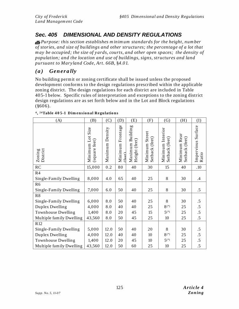
Sec. 405 DIMENSIONAL AND DENSITY REGULATIONS Purpose: this section establishes minimum standards for the height, number of stories, and size of buildings and other structures; the percentage of a lot that may be occupied; the size of yards, courts, and other open spaces; the density of population; and the location and use of buildings, signs, structures and land pursuant to Maryland Code, Art. 66B, §4.01.
(a) Generally No building permit or zoning certificate shall be issued unless the proposed development conforms to the design regulations prescribed within the applicable zoning district. The design regulations for each district are included in Table 405-1 below. Specific rules of interpretation and exceptions to the zoning district design regulations are as set forth below and in the Lot and Block regulations (§606). 4, 24Table 405-1 Dimensional Regulations
(A) (B) (C) (D) (E) (F) (G) (H) (I)
Zoni
ng
Dis
tric
t
Min
imum
Lot
Siz
e (s
quar
e fe
et)
Max
imum
Den
sity
Min
imum
Fro
ntag
e (f
eet)
M
axim
um B
uild
ing
Hei
ght (
feet
)
Min
imum
Str
eet
Setb
ack
(fee
t)
Min
imum
Int
erio
r Se
tbac
k (f
eet)
Min
imum
Rea
r Se
tbac
k (f
eet)
Impe
rvio
us S
urfa
ce
Rat
io
RC 15,000 0.2 80 40 30 15 40 .10 R4 Single-Family Dwelling 8,000 4.0 65 40 25 8 30 .4 R6 Single-Family Dwelling 7,000 6.0 50 40 25 8 30 .5 R8 Single-Family Dwelling 6,000 8.0 50 40 25 8 30 .5 Duplex Dwelling 4,000 8.0 40 40 25 8(*) 25 .5 Townhouse Dwelling 1,400 8.0 20 45 15 5(*) 25 .5 Multiple family Dwelling 43,560 8.0 50 45 25 10 25 .5 R12 Single-Family Dwelling 5,000 12.0 50 40 20 8 30 .5 Duplex Dwelling 4,000 12.0 40 40 10 8(*) 25 .5 Townhouse Dwelling 1,400 12.0 20 45 10 5(*) 25 .5 Multiple family Dwelling 43,560 12.0 50 60 25 10 25 .5
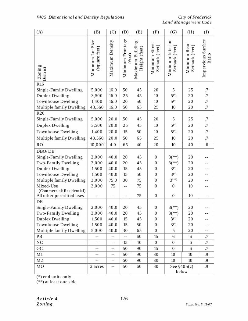
§405 Dimensional and Density Regulations City of Frederick Land Management Code
Article 4 126 Zoning Supp. No. 5, 11-07
(A) (B) (C) (D) (E) (F) (G) (H) (I)
Zoni
ng
Dis
tric
t
Min
imum
Lot
Siz
e (s
quar
e fe
et)
Max
imum
Den
sity
Min
imum
Fro
ntag
e (f
eet)
M
axim
um B
uild
ing
Hei
ght (
feet
)
Min
imum
Str
eet
Setb
ack
(fee
t)
Min
imum
Int
erio
r Se
tbac
k (f
eet)
Min
imum
Rea
r Se
tbac
k (f
eet)
Impe
rvio
us S
urfa
ce
Rat
io
R16 Single-Family Dwelling 5,000 16.0 50 45 20 5 25 .7 Duplex Dwelling 3,500 16.0 25 45 10 5(*) 20 .7 Townhouse Dwelling 1,400 16.0 20 50 10 5(*) 20 .7 Multiple family Dwelling 43,560 16.0 50 65 25 10 20 .7 R20 Single-Family Dwelling 5,000 20.0 50 45 20 5 25 .7 Duplex Dwelling 3,500 20.0 25 45 10 5(*) 20 .7 Townhouse Dwelling 1,400 20.0 15 50 10 5(*) 20 .7 Multiple family Dwelling 43,560 20.0 50 65 25 10 20 .7 RO 10,000 4.0 65 40 20 10 40 .6 DBO/DB Single-Family Dwelling 2,000 40.0 20 45 0 3(**) 20 -- Two-Family Dwelling 3,000 40.0 20 45 0 3(**) 20 -- Duplex Dwelling 1,500 40.0 15 45 0 3(*) 20 -- Townhouse Dwelling 1,500 40.0 15 50 0 3(*) 20 -- Multiple family Dwelling 3,000 75.0 30 75 0 3(**) 20 -- Mixed-Use (Commercial/Residential)
3,000 75 -- 75 0 0 10 --
All other permitted uses -- -- -- 75 0 0 10 -- DR Single-Family Dwelling 2,000 40.0 20 45 0 3(**) 20 -- Two-Family Dwelling 3,000 40.0 20 45 0 3(**) 20 -- Duplex Dwelling 1,500 40.0 15 45 0 3(*) 20 -- Townhouse Dwelling 1,500 40.0 15 50 0 3(*) 20 -- Multiple family Dwelling 5,000 40.0 30 65 0 5 20 -- PB -- -- -- 60 15 6 6 .7 NC -- -- 15 40 0 0 6 .7 GC -- -- 50 90 15 0 6 .7 M1 -- -- 50 90 30 10 10 .9 M2 -- -- 50 90 30 10 10 .9 MO 2 acres -- 50 60 30 See §405(c)
below .9
(*) end units only (**) at least one side

City of Frederick §405 Dimensional and Density Regulations Land Management Code
127 Article 4 Supp. No. 1, 9-05 Zoning
Rules for Interpretation of Table 405-1: Generally. Refer to Appendix A for definitions. A dash (“--”) indicates that the requirement does not apply within the particular zoning district. Column (A): refers to the applicable Zoning District. Column (B): The minimum lot size is the size of a lot measured within the lot lines and expressed in terms of square feet. Column (C): The maximum density requirements (Column (C)) are expressed in dwelling units per gross acre. Column (D): The frontage of a parcel of land is that distance where a property line is common with a street right-of-way line. Where a lot fronts on two (2) or more streets, minimum street frontage width requirements shall be considered met if the frontage along any one of such streets meets the minimum street frontage width requirements. Column (E): Building height is expressed in feet. Except as specifically provided elsewhere in the LMC, no part of any structure shall project beyond the building envelope defined by the minimum street and interior setbacks and the maximum heights established in the Dimensional Matrix for the zoning district in which such structure is located. Columns (F): The street setback refers to the distance from the street right-of-way line to the nearest enclosed portion of the principal building or group of buildings. A street lot line or front lot line means any lot line that abuts a street. Column (G): The interior setback is the horizontal distance extending from the side property line to the nearest enclosed portion of the principal building or group of buildings. The side property line is any lot line other than a front lot line or a rear lot line as defined for Columns (F) or (H). Column (H): the rear setback is a line extending from the rear lot line to the nearest enclosed portion of the principal building or group of buildings. The rear lot line is the lot line that is opposite and most parallel to the front lot line. If the rear lot line is less than 10 feet long or the lot comes to a point at the rear, the rear lot line is assumed to be a line not less than 10 feet long, which lies wholly within the lot and is parallel to the front lot line. The rear lot line is parallel to the chord of the arc of the lot's front lot line. Column (I): the impervious surface ratio establishes the maximum amount of new impervious surface on a lot, including building footprints and paved parking areas, by multiplying the gross land area of the lot by the ratio established in Column (I).
§405 Dimensional and Density Regulations City of Frederick Land Management Code
Article 4 128 Zoning Original Adopted Version, 7-21-05
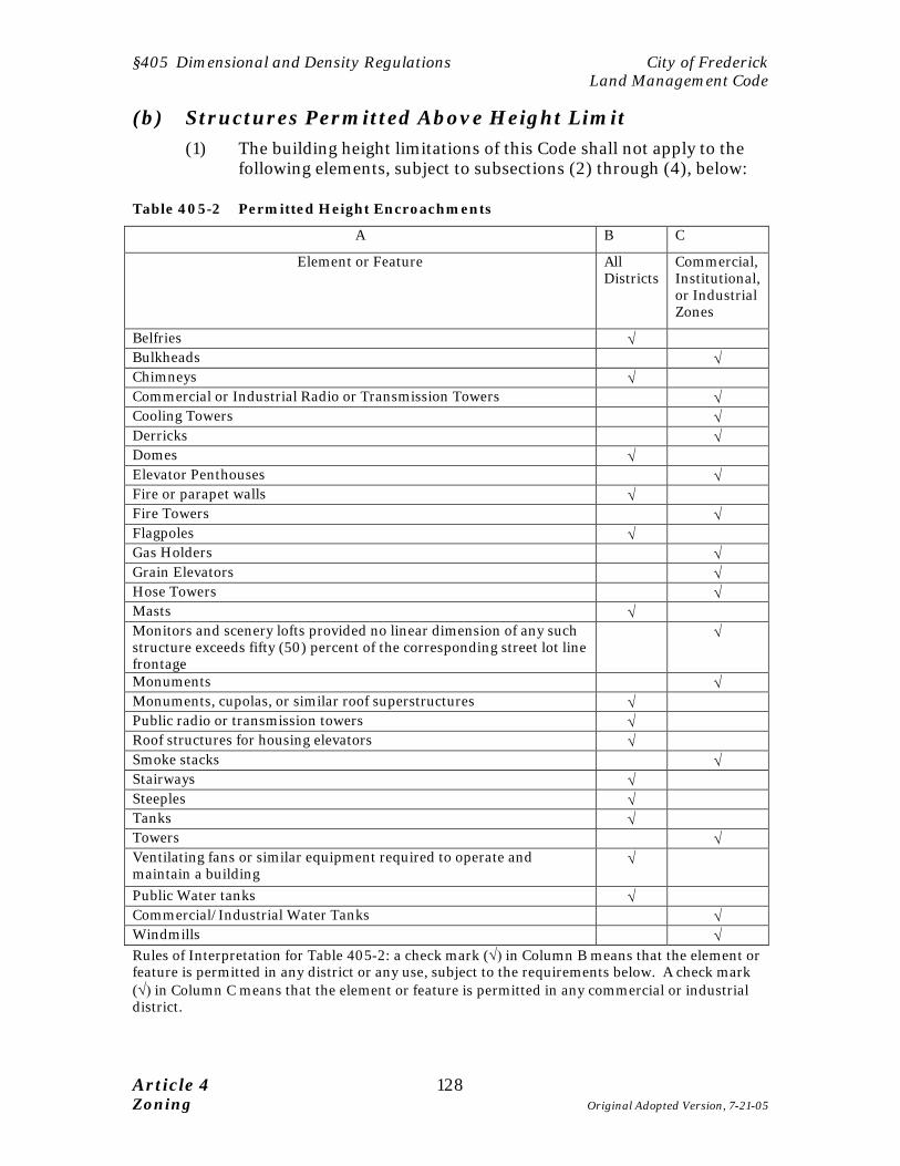
(b) Structures Permitted Above Height Limit (1) The building height limitations of this Code shall not apply to the
following elements, subject to subsections (2) through (4), below:
Table 405-2 Permitted Height Encroachments
A B C
Element or Feature All Districts
Commercial, Institutional, or Industrial Zones
Belfries √ Bulkheads √ Chimneys √ Commercial or Industrial Radio or Transmission Towers √ Cooling Towers √ Derricks √ Domes √ Elevator Penthouses √ Fire or parapet walls √ Fire Towers √ Flagpoles √ Gas Holders √ Grain Elevators √ Hose Towers √ Masts √ Monitors and scenery lofts provided no linear dimension of any such structure exceeds fifty (50) percent of the corresponding street lot line frontage
√
Monuments √ Monuments, cupolas, or similar roof superstructures √ Public radio or transmission towers √ Roof structures for housing elevators √ Smoke stacks √ Stairways √ Steeples √ Tanks √ Towers √ Ventilating fans or similar equipment required to operate and maintain a building
√
Public Water tanks √ Commercial/Industrial Water Tanks √ Windmills √ Rules of Interpretation for Table 405-2: a check mark (√) in Column B means that the element or feature is permitted in any district or any use, subject to the requirements below. A check mark (√) in Column C means that the element or feature is permitted in any commercial or industrial district.
City of Frederick §405 Dimensional and Density Regulations Land Management Code
129 Article 4 Supp. No. 2, 12-05 Zoning
(2) In commercial or industrial zoning districts:
A. The Zoning Administrator may approve a height encroachment for a feature not expressly listed in Table 405-2 if he finds that the manufacturing process or use requires a greater height.
B. No structure shall exceed 150 feet in total height above
ground. C. All such structures above the heights otherwise permitted in
the district shall not occupy more than 25 percent of the area of the lot, and shall be located at least 25 feet in all parts from every lot line other than a street lot line.
(3) The building height limitations of this Code shall not apply to
churches, schools, institutional buildings, or public utility buildings and structures, if: A. The building or structure is located at least 600 feet from any
Residential, DR, PB, or DB-O district; and B. for each three feet by which the height of such building or
structure exceeds the maximum height otherwise permitted in the district, its side and rear yards, where required, shall be increased in width or depth by an additional foot over the minimum side an rear yards required for the highest building otherwise permitted in the district; and
C. where not otherwise required, a side yard on each side and a
rear yard shall be provided equal in width or depth to one foot for each three feet of such excess height.
8 (4) The building height limitation of this Code for buildings or
structures in the M1 and M2 districts may be modified by the Planning Commission provided the following conditions are met:
A. The building or structure is located at least 600 feet from any
Residential, DR, PB, or DB-O district; and B. for each three feet by which the height of such building or
structure exceeds the maximum height otherwise permitted in the district, its side and rear yards, where required, shall be increased in width or depth by an additional foot over the minimum side an rear yards required for the highest building otherwise permitted in the district; and
§405 Dimensional and Density Regulations City of Frederick Land Management Code
Article 4 130 Zoning Original Adopted Version, 7-21-05
C. where not otherwise required, a side yard on each side and a rear yard shall be provided equal in width or depth to one foot for each three feet of such excess height.
(5) Within the Historic District Overlay (HDO) or the Carroll Creek
Overlay (CCO), no height encroachment listed in subsections (1) – (4) is permitted unless it is approved by the Reviewing Authority. A copy of the approved HDC Level I Plan shall be submitted to the Planning Commission for review at the time of submittal of the site plan.
(6) In the R16 and R20 districts, building heights exceeding the
maximum prescribed by Table 405-1 are authorized as a conditional use if 3 additional feet of side yard setback is provided for each story in excess of three.
(c) MO District – Standards setback and modifications (1) Standards
A. In the MO district, building setbacks for side and rear yards shall be 30 feet on each side if adjacent to a commercial or employment district and 100 ft. if adjacent to any other district or an Interstate Highway unless modified by the Planning Commission.
B. Maximum building coverage on any lot in the MO district
shall be 30 percent. C. Minimum landscaped area on any lot in the MO district shall
be 20 percent. D. Predominant exterior building materials must not include
the following: smooth-faced concrete block, smooth-faced tilt-up concrete panels, or pre-fabricated steel panels. Loading docks, service areas or other similar features shall be screened from view from all public streets and under no circumstances shall outdoor material storage areas be permitted in the MO district. Screening in any portion of the MO district that abuts any “R” district shall be at a minimum, Level II screening. The Planning Commission must approve the landscaping plan and may require screening above the level of Level II screening depending on the type of development within the 100 foot yard and adjacent land uses. To ensure aesthetically pleasing development compatible with adjacent or neighboring buildings, all applications for site plan approval in the MO district shall include architectural renderings or other

City of Frederick §405 Dimensional and Density Regulations Land Management Code
131 Article 4 Supp. No. 8, 12-09 Zoning
information concerning the design and materials of the proposed building.
(2) Modifications
The Planning Commission may modify the following standards provided a finding is made that the park-like intent of the MO district is being achieved and adjacent properties are being adequately buffered.
A. The minimum side and rear yard of 100 feet, when adjacent
to adjacent to a district other than commercial or employment or abutting an interstate highway, may be modified to 50 feet if the Planning Commission approves a landscaping plan which, in the Commission's opinion, provides an adequate buffer for adjacent property or meets the park-like setting standards of the MO district.
B. The building heights for all development in the MO district
shall not exceed 60 feet, except for motel or hotel use, which may be modified by the Planning Commission to a maximum of 90 feet. For any proposed building over 40 foot., one (1) foot of additional of setback is required for every foot of building height over 40 feet.
5(d) Modification to Front and Interior yard setbacks
Section 606(j) of the LMC provides for modification of front and interior yard requirements in primarily developed portions of the City.
31(e) Density Bonus for MPDUs.
(1) In General. As an incentive to developers to construct more than the minimum required number of MPDUs, a development project that is subject to the requirements of Chapter 19 of the City Code may deviate from the density regulations set forth in this article, as described in this subsection (e).
(2) Euclidean Zoning Districts. For a development project
located in any of the zoning districts established in Table 401-1 of this LMC, the maximum density set forth in Table 405-1, Column (C) may be exceeded with a corresponding increase in the MPDU requirement as set forth in subsection (e)(7) of this section.
(3) Planned Neighborhood Developments. For a PND project,
the maximum density calculated pursuant to Section 410(f)(3) of this LMC may be exceeded with a corresponding increase in the
§405 Dimensional and Density Regulations City of Frederick Land Management Code
Article 4 132 Zoning Supp. No. 8, 12-09
MPDU requirement as set forth in subsection (e)(7) of this section.
(4) Traditional Neighborhood Developments. For a TND
project, the maximum density for multiple-family or detached dwellings set forth in Table 411-1, Column (E) may be exceeded with a corresponding increase in the MPDU requirement as set forth in subsection (e)(7) of this section.
(5) Mixed Use Districts. For a MU-1 or MU-2 project, the maximum
density for residential uses set forth in Table 417-1, Column (E) may be exceeded with a corresponding increase in the MPDU requirement as set forth in subsection (e)(7) of this section.
(6) Mixed Use Employment Center. For a MXE project, the
maximum density for multiple-family dwelling units set forth in Section 418(d) may be exceeded with a corresponding increase in the MPDU requirement as set forth in subsection (e)(7) of this section.
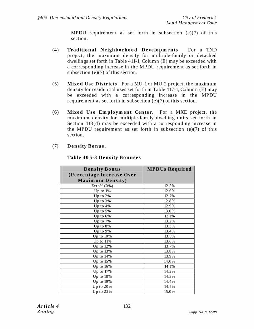
(7) Density Bonus.
Table 405-3 Density Bonuses
Density Bonus (Percentage Increase Over
Maximum Density)
MPDUs Required
Zero% (0%) 12.5% Up to 1% 12.6% Up to 2% 12.7% Up to 3% 12.8% Up to 4% 12.9% Up to 5% 13.0% Up to 6% 13.1% Up to 7% 13.2% Up to 8% 13.3% Up to 9% 13.4% Up to 10% 13.5% Up to 11% 13.6% Up to 12% 13.7% Up to 13% 13.8% Up to 14% 13.9% Up to 15% 14.0% Up to 16% 14.1% Up to 17% 14.2% Up to 18% 14.3% Up to 19% 14.4% Up to 20% 14.5% Up to 22% 15.0%

City of Frederick §406 Specific Base Zoning District Criteria Land Management Code
133 Article 4 Supp. No. 8, 12-09 Zoning
Sec. 406 SPECIFIC BASE ZONING DISTRICT CRITERIA (a) Buildings within the specified DB district
Within an area enclosed by All Saints Street and Commerce Street to the south, Wisner Street to the east, Church Street to the north, and Bentz Street to the west; buildings within the DB district only may exceed the 75 feet maximum height limitation provided that no building shall exceed an elevation of 365 feet above mean sea level.
32 (b) Residential - Office (1) Establishment, Generally. In accordance with the provisions of
this section 406(b), a professional office may be established in the RO district in: (A) A “Building” (not including an “Accessory Structure”) existing as of the effective date of this Code; (B) An “Addition” to a Building (not including an Accessory Structure) existing as of the effective date of this Code that is added to the existing Building after the effective date of this Code; or (C) A new Building. Before the construction of, or change of use to, a professional office, final major site plan approval is required.
(2) Establishment – Improved Properties. A professional office
may be established in the RO district within any “Building” (not including an Accessory Structure), existing as of the effective date of this Code.
(3) Establishment – Additions. In considering an Addition after
the effective date of this Code to a Building existing as of the effective date of this Code for the purposes of professional office use, the Planning Commission may approve a final site plan for an Addition only if it finds that: A. The Addition will be attached to the rear of the existing
Building; B. The Addition will not exceed the height of the existing
Building; C. The Addition is compatible with the existing Building, and
the existing Building as improved by the Addition, is compatible with other buildings in the surrounding block, neighborhood, or subdivision. For purposes of this subsection, compatibility is evaluated in terms of alignment, setbacks, orientation, size, appearance, and character. In

§406 Specific Base Zoning District Criteria City of Frederick Land Management Code
Article 4 134 Zoning Supp. No. 8, 12-09
demonstrating that the proposed Addition is compatible, the applicant must submit architectural elevations of the proposed Addition in relation to the existing Building and must clearly describe in a narrative format the existing block, neighborhood or subdivision area in which the proposed Addition to the existing Building is to be compared. The Planning Commission may accept or modify the applicant’s description or delineation of this area.
(4) Establishment – Unimproved Properties. On any property
in the RO district that, as of the effective date of this Code, has not been improved with a Building, a Building (not including an Accessory Structure) may be constructed for use as a professional office if the Planning Commission finds that the Building is compatible with other buildings in the surrounding block, neighborhood, or subdivision in terms of its alignment, setbacks, orientation, size, appearance, and character. In demonstrating that the proposed Building is compatible, the applicant must submit architectural elevations of the proposed Building and must clearly describe in a narrative format the existing block, neighborhood or subdivision area in which the proposed Building is to be compared. The Planning Commission may accept or modify the applicant’s description or delineation of this area.
(5) Alterations. The Planning Commission may approve an
application for “Alteration” to the elevation or façade of any Building used as a professional office in the RO district if:
A. The proposed Alteration will not change the existing
entryway, roof pitch, roof type, building materials, window proportions, or entryway proportions; or
B. The Planning Commission has granted major site plan
approval for the Alteration, finding that the Alteration will not change the residential appearance or character of the Building.
C. An “Addition” shall not be considered an “Alteration” for the
purposes of this section 406 b (5).
(6) Entrances. Common entrances are permitted in the RO district. Entrances of at least 24 feet wide for the depth of at least one car length must be provided for two-way traffic entrances. One-way in and one-way out access is permitted for entrances that are at least 14 feet wide. If needed to preserve the residential appearance of the lot and Building, access drives may be as narrow as ten feet wide in the front yard and side yard leading to the parking area.

City of Frederick §406 Specific Base Zoning District Criteria Land Management Code
135 Article 4 Supp. No. 8, 12-09 Zoning
(7) Parking. A Building within the RO district used as both a
residence and a professional office will be treated as a professional office for purposes of the parking standards of Section 607 of this Code. A parking area within the RO district must be completely screened.
(8) Traffic Impact Study. If a Building used as a dwelling unit is
converted to non-residential use, the applicant shall provide a traffic impact study as required by this Code. The Zoning Administrator may waive the traffic impact study requirement if the applicant submits a cross-access easement that provides an alternative point of access from any parking or traffic circulation area on site.
(c) RC Resource Conservation District Provisions (1) Provisions for §309, site plan review shall not apply to construction
or alteration to farm buildings or structures, however, a zoning certificate is required per §302 and all setbacks must be observed.
(2) Farm structures and accessory structures, except for fences, may
not be placed in required yards. Fences may be located in any yard not withstanding Article 7, §720, provided visibility at a public road intersection is not obstructed.
(3) A farm may include one wall or freestanding sign no larger than 20
square feet. (4) The operation of any machinery used in farming procedures and all
customary agricultural procedures is permitted.
(d) M1 and M2 Districts
(1) Generally The M1 or M2 district may, if approved by the Board of Aldermen,
be developed pursuant to the MXE Mixed-Use Employment Center Development floating zone, pursuant to the provisions of Section 418 of this Code.
§406 Specific Base Zoning District Criteria City of Frederick Land Management Code
Article 4 136 Zoning Supp. No. 2, 12-05
(2) Screening and Landscaping A.9 The Planning Commission may increase the buffer yard
planting minimum height prescribed in §605(d)(2) (landscaping standards) to seven (7) feet. The appropriate tree species shall be selected for mature heights to effectively shield the industrial buildings.
B. The Planning Commission may increase any fence or wall up
to 10 feet in height if the M1 or M2 zoned lot abuts a parcel in a residential zoning district, and the increase is needed to mitigate the impacts of the use on the residential property.
C. The determination of appropriate screening requirements to
be used in the M1 or M2 district that are adjacent to R districts shall be based on the property development status as follows:
1. Any new expansion plan of an existing industrial site
shall comply with either Level III or IV, as applicable, and nonconforming lots with existing uses or proposed downtown areas shall use Level III.
2. Any existing recorded lot not developed prior to
August 26, 2001 shall be required to use Level IV screening. However, the Planning Commission may approve Level III screening if the associated landscape plan provides an equivalent buffer for the adjacent residential property.
(e) General Commercial (GC) District In the GC zoning district, buildings that exceed sixty (60) feet in height shall be setback one (1) foot from all property lines for each foot of building height.
City of Frederick §407 Performance Standards for Flexible Zoning Techniques
137 Article 4 Supp. No. 5, 11-07 Zoning
Sec. 407 PERFORMANCE STANDARDS FOR FLEXIBLE ZONING TECHNIQUES
Purpose: this section is designed to implement the flexible zoning provisions of this Code, including the Planned Neighborhood Development, Traditional Neighborhood Development and Mixed Use Employment District by establishing performance criteria in lieu of rigid use classifications. This technique is known as "performance based zoning" or "impact zoning." Rather than defining permitted uses, this section establishes criteria that assess the impact or intensity a particular use or type of development will have on neighborhoods, the environment, infrastructure and services. Points are assigned based on criteria such as open space ratios, impervious surface ratios, and the number of dwellings (density). Accordingly, this section provides objective standards for crafting conditions for mixed use development approval, while protecting neighborhoods and preserving design flexibility. 25(a) Applicability
(1) In order to encourage mixed use development, this section applies to any of the following applications:
A. Any Master Plan; and B. An application for a conditional use permit to exceed the
dimensional standards prescribed in §405.
(2) In order to encourage a mix of uses, a PND or TND is not restricted to the uses listed in the applicable zoning district. In lieu of the use restrictions in §404, the application shall conform to the performance standards of this section. Any use, building form, or use configuration not prohibited by §§410 and 411 is permitted in those districts, so long as the overall development site conforms to the performance standards established in this section.
(3) An MXE is subject to the use restrictions established in §404 and
this section. (4) The plans subject to subsection (1) - (3), above, shall indicate the
boundaries and area for each applicable land use category. (5) The density or intensity of any lot or development site may exceed
the maximum prescribed by §405 for the applicable zoning district, subject to the approval of a conditional use permit. No such conditional use permit shall be issued unless:
A. The proposed development does not exceed the density or
intensity restrictions of §405 by more than ten percent (10%); and
§407 Performance Standards for City of Frederick Flexible Zoning Techniques Land Management Code
Article 4 138 Zoning Supp. No. 5, 11-07
B. A conditional use permit is issued in accordance with the
procedures and standards of §308; and C. The proposed development conforms to the performance
standards established in this Section.
(6) An application for a property zoned IST is subject to the requirements in §409 and this section.
(b) Performance Standards Matrix Performance standards within each zoning district, PND or Use Pattern shall conform to Table 407-1, below:
13, 14, 26 Table 407-1 Performance Standards Matrix
(A) (B) (C) (D) (E) (F) (G)
Dis
tric
t
Den
sity
FAR
Trip
Cap
per
acr
e (A
DT)
% s
torm
wat
er v
olum
e tr
eate
d by
non
-str
uctu
ral
prac
tice
s
Stre
et C
onne
ctiv
ity
Rat
io
Des
ign
Cat
egor
y Zoning Districts RC (Resource Conservation)
0.02 0.2 5% 1.2 Class C
R4 (Low Density Residential)
4 38 5% 1.2 Class C
R6 (Low Density Residential)
6 57 5% 1.2 Class C
R8 (Medium Density Residential)
8 76 5% 1.2 Class C
R12 (Medium Density Residential)
12 70 5% 1.2 Class C
R16 (High Density Residential)
16 105 5% 1.2 Class C
R20 (High Density Residential)
20 132 5% 1.2 Class C
RO (Residential - 4 .5 197 5% 1.2 Class C

City of Frederick §407 Performance Standards for Flexible Zoning Techniques
139 Article 4 Supp. No. 5, 11-07 Zoning
(A) (B) (C) (D) (E) (F) (G) D
istr
ict
Den
sity
FAR
Trip
Cap
per
acr
e (A
DT)
% s
torm
wat
er v
olum
e tr
eate
d by
non
-str
uctu
ral
prac
tice
s
Stre
et C
onne
ctiv
ity
Rat
io
Des
ign
Cat
egor
y
Office) PB (Professional Business)
2 1,444 5% 1.2 Class C
NC (Neighborhood Commercial)
0.25 913 -- 1.2 Class A
GC (General Commercial)
1.5 3,059 5% 1.2 Class C
DR (Downtown Residential)
40 251 -- 1.2 Class A
DBO (Downtown Office Commercial)
4 1,549 -- 1.2 Class A
DB (Downtown Commercial / Residential)
75 4 1,724 -- 1.2 Class A
M1 (Light Industrial)
1 304 5% 1.2 Class C
M2 (Heavy Industrial)
1 304 5% 1.2 Class C
MO (Manufacturing/ Office)
2 1,444 5% 1.2 Class C
IST (Institutional) -- -- 913 5% 1.2 Class C PND (Planned Neighborhood Development)
8 0.25 (See (d)(3)
below)
1,901 5% 1.4 Class B
TND (Traditional Neighborhood Development
See §411 for Performance Standards
MXE (Mixed Employment)
8 2 1,109 5% 1.4 Class A
MU (Mixed Use) 75 4 5,552 5% 1.8 Class A

§407 Performance Standards for City of Frederick Flexible Zoning Techniques Land Management Code
Article 4 140 Zoning Original Adopted Version, 7-21-05
(c) Density Density shall be calculated as provided in §405.
(d) Floor Area Ratio (1) For development of an individual platted lot, "floor area ratio"
means the ratio of the total building floor area to the total lot area, in square feet.
(2) For a subdivision plat, master plan, or site plan that includes
multiple buildings, "floor area ratio" means ratio of the total building floor area to the total area of the development site, in square feet.
(3) Floor Area ratio of PND relates to entire portion of the
nonresidential component of the development.
(e) Trip Generation (1) The total number of average daily trips (ADT) generated by the
proposed development shall not exceed the amount prescribed in the Performance Standards Matrix (Table 407-1), Column (D), per acre of development site. The applicant shall calculate total trips using the procedures established for Traffic Impact Studies (see Article 12.
(2) Because mixed use development involves a balance between
residential and non-residential facilities and a high level of pedestrian infrastructure, many trips are typically captured on-site or are made by non-vehicular modes such as walking or public transportation. In addition, the City finds that design standards for buildings, streets, and building-street relationships are an important factor in reducing the number of trips generated. Accordingly, an application using a TND, PND, or MXE may reduce the projected trips for all eligible uses (see subsection (4), below), as computed in accordance with the ITE Manual, by the amount shown in Table 407-2 below. In order to reduce the number of trips as provide in this subsection, the applicant shall provide a phasing schedule consistent with the following:

City of Frederick §407 Performance Standards for Flexible Zoning Techniques
141 Article 4 Original Adopted Version, 7-21-05 Zoning
A. Following approval of a final site plan and subdivision plat, the first seventy five percent (75%) of all certificates of occupancy for dwelling units shall be issued prior to the establishment of any non-residential use.
B. No certificate of use and occupancy may be issued for the
remaining dwelling units until a certificate of use and occupancy has been issued for one-hundred percent (100%) of the non-residential floor area.
Table 407-2 Trip Reductions for Mixed Use Development
Percent Residential Equivalent Units
Percent Non-residential Equivalent Units
Percent Trips Reduced
85-100% 0-14% Not Applicable 75-84% 15-25% 10% 65-74% 25-35% 20% 35-65% 35-74% 30% 25-34% 65-74% 20% 15-24% 75-84% 10% 0-14% 85-100% Not Applicable
Rules of Interpretation for Table 407-2: For purposes of computing the percentage established above, one dwelling unit or 800 square feet of non-residential space shall equal one (1) equivalent unit. The equivalent units shall be located within the boundaries of the proposed development.
(3) For purposes of this section, the overall trip generation for an
eligible use (see subsection (4), below) in the DR, DB, or DBO district shall be reduced by thirty percent (30%).
(4) For purposes of this subsection, an "eligible use" includes any
residential, retail, institutional or industrial use except Auto-Oriented Uses as defined in Article 10 of this Code.
(f) Stormwater management Stormwater credits are defined in the Maryland Department of Environment, 2000 Maryland Stormwater Design Manual, which is hereby incorporated by reference. Credits are calculated for using non-structural practices including Natural Area Conservation, Disconnection of Rooftop Runoff, Disconnection of Non Rooftop Runoff, Sheet Flow to Buffers, Open Channel Use, and Environmentally Sensitive Development. The percentage refers to the reduction in Water Quality Volume (WQv) from a development.

§407 Performance Standards for City of Frederick Flexible Zoning Techniques Land Management Code
Article 4 142 Zoning Original Adopted Version, 7-21-05
(g) Street Connectivity
Street connectivity shall be calculated in accordance with §611(j) (Street Improvement Standards).
(h) Design
Design of structures and the site shall comply with §604 (Building and Urban Design)
City of Frederick §408 Incentive Zoning Land Management Code
143 Article 4 Original Adopted Version, 7-21-05 Zoning
Sec. 408 INCENTIVE ZONING [RESERVED] Pages 143 –146 Reserved

§409 Institutional Floating Zone City of Frederick Land Management Code
Article 4 144 Zoning Supp. No. 9, 11-10
This Page Left Intentionally Blank

City of Frederick §409 Institutional Floating Zone Land Management Code
147 Article 4 Original Adopted Version, 7-21-05 Zoning
Sec. 409 INSTITUTIONAL FLOATING ZONE (IST)
Purpose and findings: this district establishes a flexible procedure and standards for siting large-scale institutional uses, such as conference centers, places of worship, schools, meeting halls, museums, public safety facilities, and government administrative offices. The City finds and determines that:
• these uses provide important services for the general public, and • these uses can generate significant traffic volumes, consume large areas
of land for parking and related facilities, and create similar adverse impacts on surrounding neighborhoods; and
• the unique demands of these facilities require flexibility and case by case review in crafting suitable development standards. Many of these uses are permitted in a base zoning district, but often require flexibility in design or scale that is not available in a base zoning district.
Accordingly, this section establishes a district whereby the City can approve the siting of these facilities, while providing discretionary review to avoid or mitigate impacts on surrounding neighborhoods.
(a) Permitted Uses The uses listed in Table 404-1 are permitted in the "IST" District.
(b) Procedures A sketch plan (see §309) is required for uses permitted in the "IST" District, unless the proposed use is exempt from site plan review by state or federal law. The sketch plan may be submitted concurrent with an application for rezoning. However, the Board of Aldermen, with a recommendation of the Planning Commission, may attach conditions to the approval of the district subject to a development agreement. In lieu of the application submittal requirements specified in Article 3, §309 and Article 11, the applicant for rezoning to an "IST" District shall address each of the review criteria of this section in their application materials. If the "IST" district is approved, the applicant must then file a site plan as set out in §309.

§409 Institutional Floating Zone City of Frederick Land Management Code
Article 4 148 Zoning Original Adopted Version, 7-21-05
(c) Standards and Review Criteria
6(1) Review Criteria for Rezoning - Designated Public Uses In reviewing an application for a proposed "IST" District, the Planning Commission and Board of Aldermen shall consider the following where indicated by Table 409-1 ("Yes" in the second column):
A. consideration of possible alternative sites for the facility in
other jurisdictions to see if a better location would be appropriate, and
B. an analysis of the extent to which the proposed facility is of a
citywide, countywide, regional or state-wide nature, and C. whether uniformity among jurisdictions should be
considered. D. whether the financial impact upon the City of Frederick can
be reduced or avoided by an intergovernmental agreement.
(2) Measures to Facilitate Siting The Planning Commission and Board of Aldermen shall analyze the following factors when considering the location, design and any conditions of approval for the facility: A. the availability of land; and B. access to transportation; and C. compatibility with neighboring uses; and D. the impact on the physical environment.
7(d) Development Standards Uses within the "IST" District are not subject to the dimensional standards of §405. However, such uses are subject to:
(1) the development standards in Articles 6 and 7 of this Code; and (2) the performance standards established in §407 of this Article.

City of Frederick §409 Institutional Floating Zone Land Management Code
149 Article 4 Original Adopted Version, 7-21-05 Zoning
Table 409-1 Permitted Uses in "IST" District
Permitted Uses
Inte
rjur
isdi
ctio
nal
Ana
lysi
s R
equi
red?
(s
ee s
ubse
ctio
n (c
)(1)
LB
CS
Func
tion
Cod
e
LBC
S St
ruct
ure
Cod
e
NA
ICS
Cod
e
Fairgrounds/Agricultural and Special Events Center No 5310
Fire, sheriff, and emergency services No 6400-6430
4500-4530 92216
Government offices or other governmental civic uses or facilities Yes 6200 - 6221 92
Libraries Yes 4242 4300 51412
Nursing Home, Assisted Living Facility, Retirement Community No 1230-1250 6250
Maintenance of government buildings and grounds, including equipment storage Yes 2450 561210
Open space, park or active recreational uses operated on a non-commercial basis No 5500 712190
Post office No 6310 491
Recreation centers Yes 5380 3200 71312
Schools, academic, continuance, alternative, adult, colleges and universities, and technical, trade, and other specialty schools No 6124-
6140 4220 6113
Gas or electric generation distribution facilities, compressor stations, or substations Yes 4310
6410-6422, 6440-6460
2211
Places of Worship No 6600 3500 --
Power generation plants Yes 6430-6434
Public utility storage and service yards Yes 2450 561210
Radio / Television Station With Transmitter Tower Yes 4231 6510 5131
Radio and TV stations and studios with no tower transmissions No 4231
Sewage treatment plant, pump stations, or lift stations Yes 4340
6300-6314
6350-6356
22132
Solid waste collection centers, solid waste transfer stations, recyclable materials, yard waste and similar items Yes 4343 562111
562119
Telecommunication towers Yes 4230 6500 5133
Water supply facilities including pump stations, dams, levees, culverts, water tanks, wells, treatment plants, reservoirs, and other irrigation facilities
Yes 6200-6290

§410 Planned Neighborhood Development City of Frederick Land Management Code
Article 4 150 Zoning Supp. No.10, 2-13
20Sec. 410 PLANNED NEIGHBORHOOD DEVELOPMENT (“PND”)
Purpose: this section -
• Encourages the integrated and creative design of a variety of land uses and housing types.
• Provides efficiencies in the use of infrastructure and streets, • Promotes affordable housing, • Maximizes open space and preserves attractive natural features, • To accomplish the purposes listed above, allows land to be developed
with integrated and/or clustered land uses on the basis of overall density rather than on the basis of conventional minimum lot and yard requirements.
• Modifies the traditional strict segregation of land uses and housing types in the base zoning districts.
• Allows design flexibility by permitting some variation in lot sizes and required yards but without an increase in density of development.
• Authorizes cluster development options that allow home buyers a choice of lot sizes according to their needs while preserving green space, tree cover, natural drainage ways, nontidal wetlands, floodplains, and open space. The reduction of lot areas pursuant to this cluster development option is considered a self-created hardship. Inadequate lot area for accessory dwelling units is not considered grounds for a hardship variance. Applicants may record a covenant advising purchasers of this condition.
• Allows for the inclusion of a neighborhood commercial component, which is to be easily accessible from all parts of the planned neighborhood development or which is a logical extension of an existing commercial area.
• Requires an overall community master plan to compensate for the absence of more conventional requirements so that the intent of this Code, and especially of this Section, is met.
37 (a) Applicability and Approval Procedures
(1) A PND may be established only in residential districts as defined in §1002 of this Code.
(2) A PND requires the approval of a Master Plan as provide in §310 of
this Code. (3) The Master Plan for a PND is subject to the performance standards
established in §407 of this Code in addition to the regulations established in this section.

City of Frederick §410 Planned Neighborhood Development Land Management Code
151 Article 4 Supp. No.10, 2-13 Zoning
(4) All other requirements of this Code not expressly eliminated or modified by this section apply to a PND.
(b) Review Criteria
(1) In reviewing the application and PND Master Plan, the Planning Commission shall consider, among other things, the consequences of the plan or traffic flow, the economic provision of public services, maintenance of open space and preservation of sensitive natural areas, the extent to which the development is planned as a unit, the relationship of activities within the development, and particularly the compatibility of the planned neighborhood with properties not a part of such development.
(2) In exercising its discretion as to the approval or disapproval of a
planned neighborhood, the Planning Commission shall be guided by consideration of suitability and desirability of such development in relation to its location and surroundings. No such development shall be approved unless the Commission finds that it will constitute a primarily residential environment of continuing desirability and stability, in reasonable harmony with the character of the surrounding neighborhood and ensuring substantially the same or a higher standard of development than that which occurs pursuant to the Euclidean zoning district in which the PND standards are being applied.
(c) PND Development Phasing (1) The PND Master Plan shall include a phasing schedule for the
construction of infrastructure, including streets, water, sewer, stormwater management, parks and open space, and schools. If a development that is to be built in phases or stages includes improvements that are designed to relate to, benefit, or be used by the entire development (such as a swimming pool or tennis courts in a residential development) then, as part of the application, the developer shall submit a proposed schedule for completion of such improvements. The schedule shall relate completion of such improvements to completion of one or more phases or stages of the entire development. Once a schedule has been approved and made part of the Master Plan, no land may be used and no buildings may be occupied except in accordance with the schedule approved as part of the Master Plan.
(2) Areas of construction and areas for development shall have associated phases clearly identified on the plan.
§410 Planned Neighborhood Development City of Frederick Land Management Code
Article 4 152 Zoning Supp. No.10, 2-13
(d) Permitted Uses (1) Except as otherwise prohibited by this section, a planned
neighborhood may include dwelling types and uses other than those permitted in the Euclidean zoning district(s) in which the PND standards are being applied for the purpose of creating a self-contained neighborhood having a variety of housing types and related service facilities.
(2) Commercial areas within a PND shall comply with the following:
A. Commercial areas shall not exceed one acre for every 100
dwelling units.
B. The PND Master Plan shall identify areas for general commercial and areas for neighborhood commercial uses and building forms.
C. For purposes of subsection B, "neighborhood commercial" means commercial areas with use and design standards generally consistent with the NC district. Neighborhood commercial uses are permitted by right as part of the PND Master Plan.
D. For purposes of subsection B, "general commercial" means commercial areas with use and design standards that are generally consistent with the GC district. An area designated as general commercial shall not be approved as part of a PND Master Plan unless a separate rezoning to the "GC" zoning district is approved.
(3) Senior living facilities shall be permitted in a specially designed or thematically planned neighborhood where such facilities would be appropriate, on the basis of one bed for each 250 square feet of lot area, excluding on-site restaurant, retail and personal services available to the residents and the general public.
(4) Retail commercial and residential uses may be mixed in a specially
designed or thematic commercial portion of a planned neighborhood, where such mixing of uses would be of significant benefit to the overall character of that particular planned neighborhood.
(5) In accordance with Section 802, Accessory Detached Dwelling
Units (ADDUs) are permitted in PND.

City of Frederick §410 Planned Neighborhood Development Land Management Code
Supp. No. 10, 2-13 153 Article 4 Zoning
(e) Dimensional and Density Standards
(1) The dimensional regulations, including lot size, frontage, height, setback, and impervious surface ratio established in §405, Table 405-1 for the Euclidean district in which the PND standards are being applied may be modified by the Planning Commission subject to the following limitations:
A. The minimum street setback as required under §405 for the
district must be provided for lots which front on an arterial street.
B. The minimum lot size as required under §405 for the district
maybe required by the Planning Commission for any lot which adjoins a major arterial, railroad, or a multifamily, commercial, industrial or other nonresidential area.
C. Any structure that exceeds the building height normally
applicable to an adjoining zoning district shall be set back from the boundary of the PND a distance equal to twice its proposed height or 90 feet, whichever is greater. In no case shall a structure exceed 90 feet in height.
(2) The maximum density within a PND is determined by dividing the
gross area (in square feet) of each zoning district within the tract by the least minimum lot area per dwelling unit specified in §405 for each district. The sum of the units allowed for all districts within the Planned Neighborhood is the maximum number of units allowed.
(3) The setback and lot coverage requirements for accessory structures
as set forth in §803 of this Code maybe modified within a PND provided that:
A. the distance between the principal structure and the
accessory structure is at least six feet; B. the distance between the structure and a public right of way
is at least six feet; and C. the structure is not located within the sight distance triangle
as described in §611 of this Code.

§410 Planned Neighborhood Development City of Frederick Land Management Code
Article 4 154 Zoning Supp. No.10, 2-13
(f) Environmental Standards (1) No structures subject to a PND Master Plan shall be located within
the floodplain areas designated for protection from clearing or cutting pursuant to the Frederick City Forest Conservation Ordinance (§721), threatened or endangered species habitat, or any other environmentally sensitive areas subject to Article 7 of this Code.
(2) No structures subject to a PND Master Plan shall be located within
areas subject to slopes exceeding twenty-five percent (25%). For purposes of this Section, “areas subject to slopes” includes only those areas of size 400 square feet or greater. The Planning Commission may modify this requirement if the applicant demonstrates that construction is not unsafe and will not create landslides, stormwater discharge, or erosion beyond what would occur on slopes of less than 25%, subject to any conditions presented in the application. The applicant shall provide the following information if a modification is requested:
A. a detailed site analysis of soil conditions, B. a detailed site analysis of hydrology, C. a detailed site analysis of bedrock conditions, and D. a detailed site analysis of any other engineering and
environmental considerations as may be required to determine whether the proposed development will create a threat to the public health, safety and general welfare or cause land subsidence, erosion, or increases in the rate of volume of stormwater entering adjoining properties.
(g) Infrastructure Standards (1) In order to adequately provide for planned public park, and other
facilities that conform to the Comprehensive Plan, a PND Master Plan shall include dedication of land for schools, police/fire stations, or libraries:
A. as proposed by the Comprehensive Plan or by a City or
County agency, and that are roughly proportionate to the impacts of the development, or
B. as included in a Development Rights and Responsibilities
Agreement.
City of Frederick §410 Planned Neighborhood Development Land Management Code
Supp. No. 10, 2-13 155 Article 4 Zoning
(2) Land dedicated pursuant to subsection (g)(1) of this section shall be
dedicated as part of the development process. Compensation shall be provided to the property owner by allowing those dwelling units lost by such public land dedication to be developed elsewhere on the property. (See subsection (f)(3)).
(3) The Planning Commission may approve design modifications
according to City standards for roads, lighting, sidewalks, utilities, and other public facilities, if the Planning Commission determines that the requested modifications:
A. are compatible with surrounding neighborhood, B. are compatible with the overall development of the City, C. will not be detrimental to public health and safety or to the
delivery of public services to the future residents of the PND, including police, fire protection, emergency services, utilities, solid waste collection, and schools; and
D. are subject to mitigation measures that resolve the issues
and address the purpose of the regulations that are subject to modification.
(h) Design Standards
(1) The Master Plan shall include design standards governing the form and architectural design of buildings, the design and location of parking areas, pedestrian circulation patterns, as well as the design of public spaces including but not limited to plazas, arcades, and squares. A design booklet of the building forms and architecture shall be submitted with the application.
(2) Any PND applicant meeting the criteria herein may submit requests
for alternative design modifications described in this section with submission of a PND Master Plan application, or after Commission approval of a PND Master Plan.
(3) The Commission may approve any proposal for fencing of sections
of the PND, or in any required yard of individual lots within a section, provided that:
A. The fencing is part of an overall fencing plan for the PND;
B. the Commission finds that the fencing plan is in harmony
with the intent and design of the PND;
§410 Planned Neighborhood Development City of Frederick Land Management Code
Article 4 156 Zoning Supp. No.10, 2-13
C. the fencing is compatible with surrounding residential
developments; and
D. the fencing is approved by the City Engineer as to compatibility with City highway safety standards.
(3) The applicant shall provide an overall sign plan as part of the PND Master Plan in accordance with §864 of this Code.
(4) Parking and loading standards within a PND must comply with §607 of this Code. On-street parking may be provided in a PND by a modification granted by the Planning Commission pursuant to §410 of this Code.

City of Frederick §411 Traditional Neighborhood Development (“TND”) Land Management Code
157 Article 4 Supp. No. 9, 11-10 Zoning
18Sec. 411 TRADITIONAL NEIGHBORHOOD DEVELOPMENT (“TND”) Purpose: The Traditional Neighborhood Development (TND) option is designed to permit the development of land in a manner consistent with the historic and timeless principles of Frederick's existing neighborhoods. A TND combines a variety of housing types with commercial and civic uses in a compact, walkable neighborhood setting. TND’s feature a highly interconnected street network and setbacks appropriate to create a public realm built on a human scale. A TND should be developed such that the street network recognizes and complements a site’s topography and other natural features. This section provides a "form-based" code framework to authorize TND's. It establishes minimum densities, build-to lines (maximum setbacks), and design standards to ensure that new development conforms to the Comprehensive Plan's principles for urban design. It also permits a limited number of cul-de-sacs and conventional building forms in order to provide market flexibility. This section implements the following policies of the Comprehensive Plan:
• LU1.4 - implement small area plans through urban design as well as recommended land use or redevelopment changes.
• LU.9.3 - Facilitate the development of communities that mix residential, institutional, commercial and office uses to provide convenience, increase opportunities for walking and transit service, and reduce the number and length of automobile trips. The non-residential uses in these communities should be compatible in design and scale with surrounding neighborhood development.
• LU.9.4 - Implement interconnections between neighborhoods, including more street grids and non-motorized pathways.
• LU.9.6 - Develop regulatory incentives for mixed use development that encourage the planned, coordinated development of mixed land uses on adjacent properties.
• LU.12.5 - Explore ways to retrofit certain existing neighborhoods with traditional neighborhood design aspects to enhance walkability.
• LU.13.4 - Consider providing incentives that encourage developers to achieve high-quality design and energy efficiency in new developments.
• T.4 - As part of the update to the City’s development regulations, review and update existing standards for different types of roadways and bicycle and pedestrian facilities.
• T.7.2 - Improve the safety of pedestrian and bicycle travel through revised roadway design standards that accommodate all modes of transportation, reduce travel speeds on local and collector roads and/or employ traffic calming measures.

§412 – 416 Reserved City of Frederick Land Management Code
Article 4 158 Zoning Supp. No. 3, 9-06

City of Frederick §412 – 416 Reserved Land Management Code
159 Article 4 Original Adopted Version, 7-21-05 Zoning
(a) Applicability and Approval Procedures (1) A TND may be approved in any zoning district except M1, M2 or
MO. (2) A TND requires the approval of a Master Plan as provided in §310
of this Code. (3) The Master Plan for a TND is subject to the performance standards
established in §407 of this Code in addition to the regulations established in this section.
(4) All requirements of this Code not expressly eliminated or modified
by this section apply to the TND.
(b) Land Use and Density
(1) Density
The Master Plan must indicate the requested densities, in terms of number of units per gross residential acre and total number of dwelling units. The Subdivision Plat or Master Plan for a TND must comply with Table 411-1.
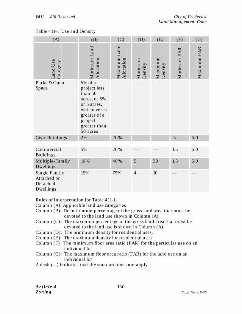
§412 – 416 Reserved City of Frederick Land Management Code
Article 4 160 Zoning Supp. No. 3, 9-06
Table 411-1 Use and Density
(A) (B) (C) (D) (E) (F) (G)
Land
Use
C
ateg
ory
Min
imum
Lan
d A
lloca
tion
Max
imum
Lan
d A
lloca
tion
Min
imum
D
ensi
ty
Max
imum
D
ensi
ty
Min
imum
FA
R
Max
imum
FA
R
Parks & Open Space
5% of a project less than 50 acres, or 5% or 5 acres, whichever is greater of a project greater than 50 acres
— — — — —
Civic Buildings 2% 20% — — .5 6.0 Commercial Buildings
5% 20% — — 1.5 6.0
Multiple-Family Dwellings
10% 40% 5 30 1.5 6.0
Single Family Attached or Detached Dwellings
15% 75% 4 10 — —
Rules of Interpretation for Table 411-1: Column (A): Applicable land use categories Column (B): The minimum percentage of the gross land area that must be
devoted to the land use shown in Column (A) Column (C): The maximum percentage of the gross land area that must be
devoted to the land use is shown in Column (A). Column (D): The minimum density for residential uses, Column (E): The maximum density for residential uses Column (F) The minimum floor area ratio (FAR) for the particular use on an
individual lot Column (G): The maximum floor area ratio (FAR) for the land use on an
individual lot A dash (—) indicates that the standard does not apply.
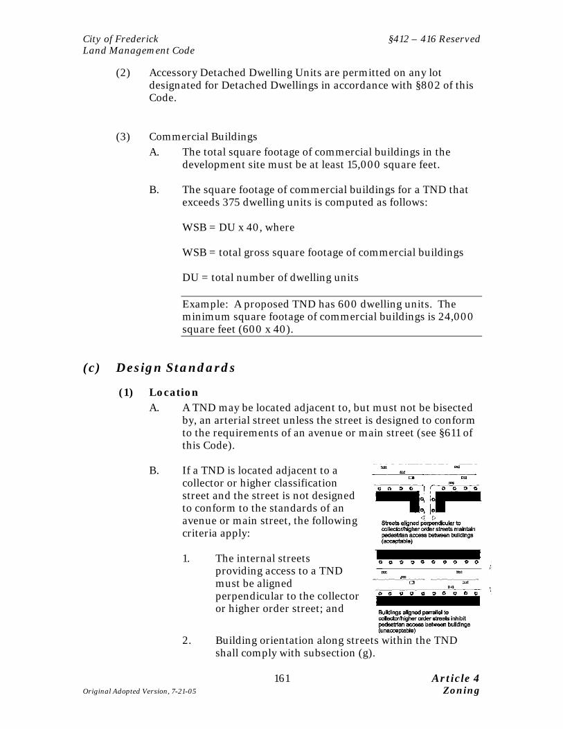
City of Frederick §412 – 416 Reserved Land Management Code
161 Article 4 Original Adopted Version, 7-21-05 Zoning
(2) Accessory Detached Dwelling Units are permitted on any lot designated for Detached Dwellings in accordance with §802 of this Code.
(3) Commercial Buildings A. The total square footage of commercial buildings in the
development site must be at least 15,000 square feet. B. The square footage of commercial buildings for a TND that
exceeds 375 dwelling units is computed as follows:
WSB = DU x 40, where WSB = total gross square footage of commercial buildings DU = total number of dwelling units
Example: A proposed TND has 600 dwelling units. The minimum square footage of commercial buildings is 24,000 square feet (600 x 40).
(c) Design Standards
(1) Location A. A TND may be located adjacent to, but must not be bisected
by, an arterial street unless the street is designed to conform to the requirements of an avenue or main street (see §611 of this Code).
B. If a TND is located adjacent to a
collector or higher classification street and the street is not designed to conform to the standards of an avenue or main street, the following criteria apply:
1. The internal streets
providing access to a TND must be aligned perpendicular to the collector or higher order street; and
2. Building orientation along streets within the TND shall comply with subsection (g).
§412 – 416 Reserved City of Frederick Land Management Code
Article 4 162 Zoning Supp. No. 3, 9-06
(2) TND Subareas
The area covered under the Master Plan must be divided into the following subareas:
A. The Center Subarea B. The Neighborhood Subarea(s) C. Parks and Open Space Subarea(s)
(A) The Center Subarea
1. May include civic, retail, service, and multi-family uses; 2. Shall only be located on a Main Street (as described in §611
of this Code); 3. May face or surround the Square or Plaza; 4. Must connect to the residential components of the
community via a continuous system of sidewalks; and
(B) The Neighborhood Subarea 1. Permitted land uses include multi-family and single-family
attached and detached uses, small-scale retail and service uses, and public outdoor gathering places.
2. All areas within a Neighborhood should be within a five-
minute walking distance from edge to edge. 3. A Neighborhood must be not less than ten acres or more
than 40 acres in size, excluding greenbelts.
(C) The Park and Open Space Subarea The Plaza provides a community focal point and public gathering place, while the Greenbelt provides a clear edge to the community, open space for community residents, and natural areas for stormwater management. See subsection (c)(8).
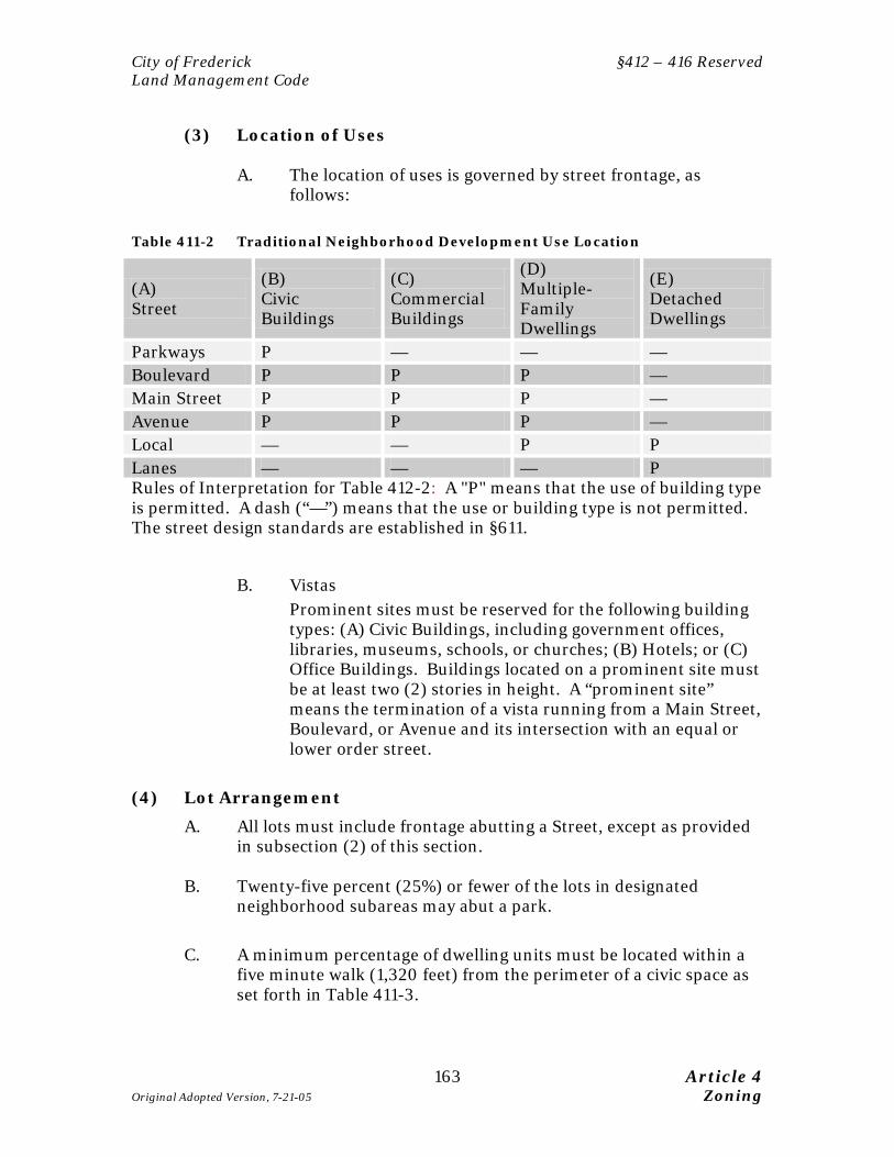
City of Frederick §412 – 416 Reserved Land Management Code
163 Article 4 Original Adopted Version, 7-21-05 Zoning
(3) Location of Uses
A. The location of uses is governed by street frontage, as
follows:
Table 411-2 Traditional Neighborhood Development Use Location
(A) Street
(B) Civic Buildings
(C) Commercial Buildings
(D) Multiple-Family Dwellings
(E) Detached Dwellings
Parkways P — — — Boulevard P P P — Main Street P P P — Avenue P P P — Local — — P P Lanes — — — P Rules of Interpretation for Table 412-2: A "P" means that the use of building type is permitted. A dash (“—”) means that the use or building type is not permitted. The street design standards are established in §611.
B. Vistas Prominent sites must be reserved for the following building types: (A) Civic Buildings, including government offices, libraries, museums, schools, or churches; (B) Hotels; or (C) Office Buildings. Buildings located on a prominent site must be at least two (2) stories in height. A “prominent site” means the termination of a vista running from a Main Street, Boulevard, or Avenue and its intersection with an equal or lower order street.
(4) Lot Arrangement
A. All lots must include frontage abutting a Street, except as provided in subsection (2) of this section.
B. Twenty-five percent (25%) or fewer of the lots in designated
neighborhood subareas may abut a park.
C. A minimum percentage of dwelling units must be located within a
five minute walk (1,320 feet) from the perimeter of a civic space as set forth in Table 411-3.

§412 – 416 Reserved City of Frederick Land Management Code
Article 4 164 Zoning Supp. No. 3, 9-06
Table 411-3 TND Lot Distribution
TND Size Percent of lots within 5-minute walk from Civic Center
< 80 acres 80% 80 acres or more 50%
D. Blocks must have an average length not exceeding 400 feet, with no
block exceeding 1,000 feet in length. (5) Dimensional Regulations
A. The minimum lot size and impervious surface ratio established in
§405 of this Code maybe modified by the Commission to more closely correspond with the setback and frontage standards established in Table 411-4.
B. The setback for principal buildings must be as set forth in Table
411-4. The frontage and setback requirements do not apply to parks and open space. In order to allow for variations for unique uses, such as anchor retail tenants or auditoriums, the maximum frontage requirements in Column (C) must be computed as an average.
C. The setback and lot coverage requirements for accessory structures
per §803 maybe modified within a TND provided: 1. the distance between the principal structure and the
accessory structure is a minimum of 6’; and 2. the required distance between the structure and a public
right of way is at least 6’ and 3. the structure is not located within the sight distance triangle
as described in §611 of this Code.
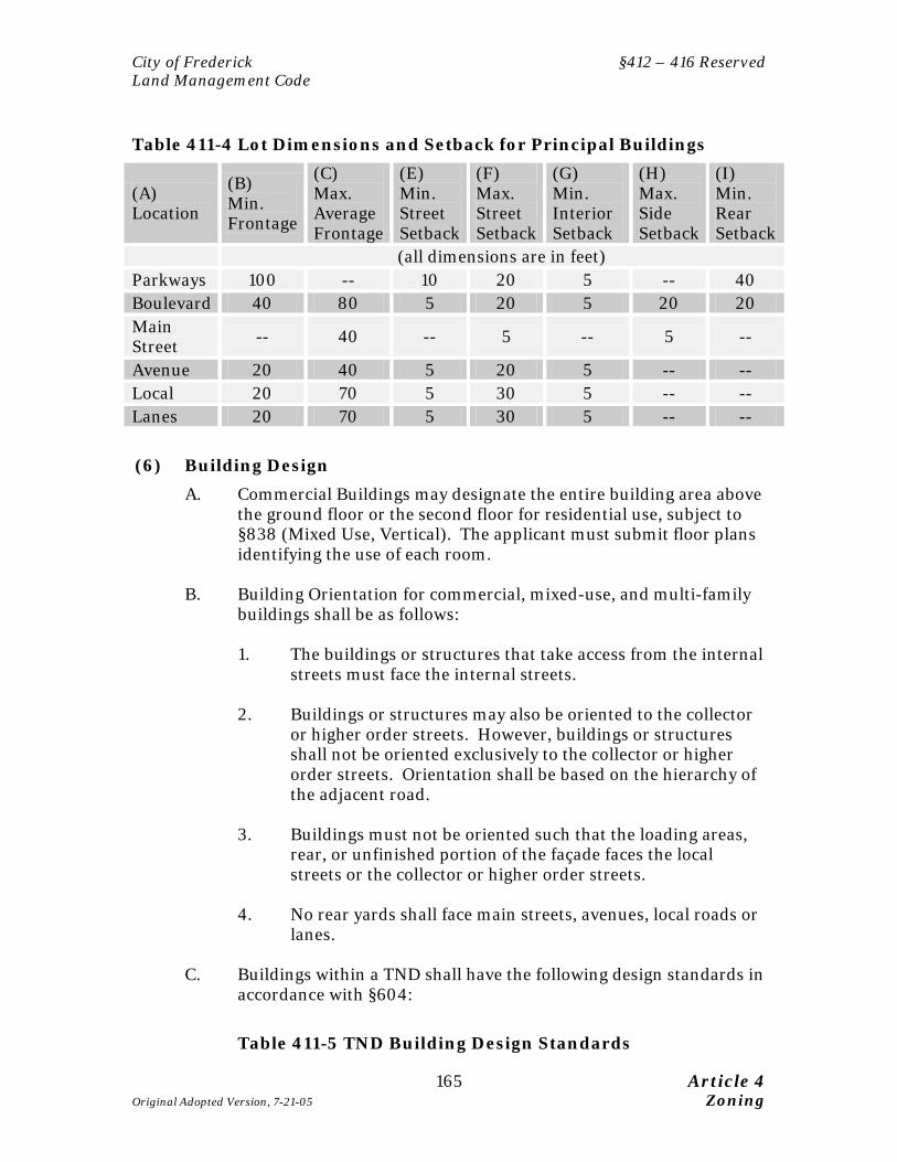
City of Frederick §412 – 416 Reserved Land Management Code
165 Article 4 Original Adopted Version, 7-21-05 Zoning
Table 411-4 Lot Dimensions and Setback for Principal Buildings
(A) Location
(B) Min. Frontage
(C) Max. Average Frontage
(E) Min. Street Setback
(F) Max. Street Setback
(G) Min. Interior Setback
(H) Max. Side Setback
(I) Min. Rear Setback
(all dimensions are in feet) Parkways 100 -- 10 20 5 -- 40 Boulevard 40 80 5 20 5 20 20 Main Street -- 40 -- 5 -- 5 --
Avenue 20 40 5 20 5 -- -- Local 20 70 5 30 5 -- -- Lanes 20 70 5 30 5 -- -- (6) Building Design
A. Commercial Buildings may designate the entire building area above the ground floor or the second floor for residential use, subject to §838 (Mixed Use, Vertical). The applicant must submit floor plans identifying the use of each room.
B. Building Orientation for commercial, mixed-use, and multi-family
buildings shall be as follows:
1. The buildings or structures that take access from the internal streets must face the internal streets.
2. Buildings or structures may also be oriented to the collector
or higher order streets. However, buildings or structures shall not be oriented exclusively to the collector or higher order streets. Orientation shall be based on the hierarchy of the adjacent road.
3. Buildings must not be oriented such that the loading areas,
rear, or unfinished portion of the façade faces the local streets or the collector or higher order streets.
4. No rear yards shall face main streets, avenues, local roads or
lanes. C. Buildings within a TND shall have the following design standards in
accordance with §604:
Table 411-5 TND Building Design Standards
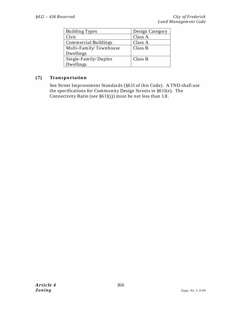
§412 – 416 Reserved City of Frederick Land Management Code
Article 4 166 Zoning Supp. No. 3, 9-06
Building Types Design Category Civic Class A Commercial Buildings Class A Multi-Family/Townhouse Dwellings
Class B
Single-Family/Duplex Dwellings
Class B
(7) Transportation
See Street Improvement Standards (§611 of this Code). A TND shall use the specifications for Community Design Streets in §611(e). The Connectivity Ratio (see §611(j)) must be not less than 1.8.

City of Frederick §412 – 416 Reserved Land Management Code
167 Article 4 Original Adopted Version, 7-21-05 Zoning
(8) Parks and Open Space
A. At least one of the following park types (referred to here as "Civic Spaces"), as defined in §608, must be included in any TND:
Linear Park Green Square Park Playground or Tot Lot Plaza Dog Park
(B) No lot or dwelling unit within a TND shall be located further than
the following distances from a civic space, measured from the exterior boundaries of the center and the exterior boundaries of the lot or building footprint:
Table 411-6 TND Civic Space Distancing Standards
Location Maximum Distance from Civic Space
Within 1,320 feet (¼ mile) of the Center 800 feet Between 1,320 (> ¼ mile) - 5,280 feet (1 mile) from the Center
1,320 (¼ mile)
More than 5,280 feet (1 mile) from the Center
2,640 feet (½ mile)
(9) Landscaping and Screening
The following standards of §605 do not apply to a TND:
A. Landscape buffers and berms (§605(e)); and B. Parking lot interior landscaping requirements (§605(g)) for
any parking area that is located in a rear yard or interior to a block.
(10) Parking
A. The minimum parking space requirements of the Parking Standards (§607(b)) do not apply to a TND.
B. Parking lots must be located at the rear of principal buildings or
interior to a block. C. Parking lots and parking garages must not:
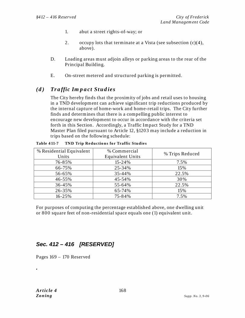
§412 – 416 Reserved City of Frederick Land Management Code
Article 4 168 Zoning Supp. No. 3, 9-06
1. abut a street rights-of-way; or 2. occupy lots that terminate at a Vista (see subsection (c)(4),
above). D. Loading areas must adjoin alleys or parking areas to the rear of the
Principal Building. E. On-street metered and structured parking is permitted.
(d) Traffic Impact Studies The City hereby finds that the proximity of jobs and retail uses to housing in a TND development can achieve significant trip reductions produced by the internal capture of home-work and home-retail trips. The City further finds and determines that there is a compelling public interest to encourage new development to occur in accordance with the criteria set forth in this Section. Accordingly, a Traffic Impact Study for a TND Master Plan filed pursuant to Article 12, §1203 may include a reduction in trips based on the following schedule:
Table 411-7 TND Trip Reductions for Traffic Studies
% Residential Equivalent Units
% Commercial Equivalent Units % Trips Reduced
76-85% 15-24% 7.5% 66-75% 25-34% 15% 56-65% 35-44% 22.5% 46-55% 45-54% 30% 36-45% 55-64% 22.5% 26-35% 65-74% 15% 16-25% 75-84% 7.5%
For purposes of computing the percentage established above, one dwelling unit or 800 square feet of non-residential space equals one (1) equivalent unit.
Sec. 412 – 416 [RESERVED] Pages 169 – 170 Reserved
.
City of Frederick §412 – 416 Reserved Land Management Code
169 Article 4 Original Adopted Version, 7-21-05 Zoning
This Page Left Intentionally Blank

City of Frederick §417 Mixed Use Districts (MU-1 and MU-2) Land Management Code
171 Article 4 Supp. No. 10, 2-13 Zoning
34,37 Sec. 417 MIXED USE DISTRICTS (MU-1 and MU-2) Purpose:
• This section implements the "Planned Mixed Use" future land use classification of the Comprehensive Plan.
• Design standards are established for MU districts pursuant to the "Planned Mixed Use Designation" policies of the Comprehensive Plan.
• The MU District provides a flexible procedure for the approval of developments that provide compact, pedestrian friendly neighborhoods, but that cannot conform to some of the standards of §411 of this Article. The MU district procedure offers a discretionary, case by case review procedure for such developments in lieu of the more predictable, ministerial process established in §411.
• This Section encourages the incorporation into a single project a compatible mixture of residential, commercial, employment, recreational, civic and/or cultural uses, which are developed under an overall master plan of the unified planned development.
• The primary objective for a property developed under the Mixed Use (MU) zoning district is to provide a combination of uses including residential and non-residential uses. Non-residential uses may include office, other employment, retail, and institutional uses.
• The MU-1 district is a base or Euclidean zone. It is established as part of the comprehensive zoning map that accompanies this Code.
• The MU-2 district is a floating zone. It may be approved on any property if the Mayor and Board of Aldermen find that the general requirements set forth in this Section have been met.
(a) Applicability and Approval Procedures (1) The standards established in this section apply to any property
zoned MU-1 or proposed for MU-2 zoning. (2) The MU-2 district is established as a floating zone that may be
applied to properties not within the MU-1 zoning district as of the effective date of this Code. The MU-2 district may be applied to any tract that complies with the requirements of this Section. The Master Plan for an MU-2 District must include (1) or more contiguous tracts of land under the ownership or control of a single developer or owner, or two (2) or more contiguous tracts of land owned by two (2) or more owners if they have filed for the MU district under a joint application. Tracts separated by only a public or private street or other right-of-way are deemed to be contiguous for purposes of this Section, provided pedestrian linkages and connectivity between the tracts can be provided to meet the purpose, objectives and standards of the MU-2 district.

§417 Mixed Use Districts (MU-1 and MU-2) City of Frederick Land Management Code
Article 4 172 Zoning Supp. No. 10, 9-12
(3) An MU-1 development requires approval of a Master Plan in
accordance with §310 of this Code.
(4) An MU-2 development requires approval of a conditional rezoning to the MU-2 district (§307) and a Master Plan (§310).
(5) The Master Plan for a MU-1 or MU-2 development is subject to the
performance standards established in §407 of this Code in addition to the regulations established in this section.
(6) All requirements of this Code not expressly eliminated or modified
by this section apply to development in the MU-1 and MU-2 districts.
(b) Uses, Densities/Intensities and Land Allocation (1) The Master Plan for an MU-1 or MU-2 District must include the
following land uses. The minimum land area that includes the required uses, densities, and floor area ratio for each use shall conform to Table 417-1, below. The Subdivision Plat and Master Plan for an MU District must comply with Table 417-1, below.
Table 417-1 Uses, Densities/Intensities and Land Allocation
(A) (B) (C) (D) (E) (F) (G) Land Use Category
Min
imum
La
nd
Allo
cati
on
Max
imum
La
nd
Allo
cati
on
Min
imum
D
ensi
ty
Max
imum
D
ensi
ty
Min
imum
FA
R
Max
imum
FA
R
Parks & Open Space 5% (for projects less than 50 acres); 5% or 5 acres, whichever is greater (for projects over 50 acres)
— — — — —
Non-residential Uses 15% 85% — — 0.25 4.0 Residential Uses 15% 85% 7 75 — —
(2) Mixed Use Buildings and Live-Work Units:
A. must comply with Article 8 §838, and

City of Frederick §417 Mixed Use Districts (MU-1 and MU-2) Land Management Code
173 Article 4 Supp. No. 10, 2-13 Zoning
B. 60% the land area devoted to Mixed Use Buildings is counted as a Residential Use and 40% is counted as a non-residential use for purposes of Table 417-1, and
C. Live-Work Units are considered Residential Uses for
purposes of Table 417-1.
(3) The Planning Commission may grant modifications to the standards set forth in Table 417-1 for redevelopment projects provided compensating features are included to address the modifications.
22(4) ADDU development must comply with Section 802 of the Land
Management Code.
(c) Design Standards
(1) Building Spacing
A. The setback for principal buildings must conform to Table 417-2. The frontage and setback requirements do not apply to structures within Parks and Open Space. In order to allow for variations for unique uses, such as anchor retail tenants or auditoriums, the minimum frontage requirements in Column (B) of Table 417-2 must be computed as an average.
Table 417-2 Setback for Principal Buildings - MU District
(A) Location/Land Use Category
(B) Min. Frontage
(C) Min. Street Setback
(D) Max. Street Setback
(E) Min. Interior Setback
(F) Max. Interior Setback
(G) Min. Rear Setback
(all dimensions are in feet) Non-residential 10 0 35 0 25 5 Residential: Detached Dwellings 40 20 -- 5 -- 20 Attached / Duplex / Townhouse Dwellings
15 5 35 5 -- 20
Multiple-Family Dwellings
15 0 35 5 -- 20
B. The Planning Commission may grant modifications to the
standards set forth in Table 417-2 for redevelopment projects provided compensating features are included to address the modifications.
§417 Mixed Use Districts (MU-1 and MU-2) City of Frederick Land Management Code
Article 4 174 Zoning Supp. No. 10, 9-12
C. The setback and lot coverage requirements for accessory structures as established in §803 of this Code maybe modified within a mixed use development provided (1) the distance between the principal structure and the
accessory structure is a minimum of six feet; and (2) the distance between the structure and a public right
of way is at least six feet and (3) the structure is not located within the sight distance
triangle as described in §611 of this Code.
(2) Building Orientation
Buildings shall be "oriented to the street" as defined in §604(d)(3).
(3) Pedestrian Amenities Pedestrian amenities such as benches, awnings, and canopies shall be provided on all sidewalks in a non-residential land use category. Street trees shall be provided as required in §§605(f) and 611(e).
(4) Open Space / Civic Spaces Open spaces and civic spaces within an MU district shall spaced so that no lot, building or dwelling unit is located further than the distance prescribed in Table 417-3 from parkland that complies with §608:
Table 417-3 Open and Civic Spaces in MU District
Land Use Category Maximum Spacing Non-Residential 1/2 mile Residential: Detached Dwellings 1/2 mile Attached / Duplex / Townhouse / Multiple-Family Dwellings 1/4 mile
(5) Sidewalks
City of Frederick §417 Mixed Use Districts (MU-1 and MU-2) Land Management Code
175 Article 4 Supp. No. 10, 2-13 Zoning
Sidewalks shall be provided on both sides of each street, and shall conform to the requirements of §611(s).
(6) Parking
Parking areas shall be located in the rear and side yard and shall not be located between a Principal Building and a street other than an alley “unless modified by the Planning Commission.” If proposed shared parking shall be provided as specified in §607(c)(3).
(7) Streets
A. Blocks must have an average length not exceeding four-hundred (400) feet.
B. The street connectivity ratio (see §611(j)(2)) shall be at
least 1.2. C. At least one bus or transit shelter must be provided along
every street that is located on a Maryland Transit Administration (MTA) commuter bus service route, or Frederick County TransIT bus route. Pedestrian amenities as required by subsection (4), above, must be provided along any sidewalk that provides access to a Transit Station.
(8) Outside Storage and Off-Street Loading A. Outside storage within an MU district shall be prohibited.
Storage of materials waiting processing, delivery, sales, or the like shall be fully enclosed within building.
B. Off-street loading shall not be along arterial roads, or a main
street.
(d) Phasing Construction of the MU project must be phased such that:
(1) Building permits for no more than 75% of the residential dwelling
units may be issued until at least 25% of the non-residential floor area is constructed; and
(2) Building permits for no more than 75% of the non-residential floor
area may be issued until record plats for at least 25% of the dwelling

§417 Mixed Use Districts (MU-1 and MU-2) City of Frederick Land Management Code
Article 4 176 Zoning Supp. No. 10, 9-12
units have been recorded among the Land Records of Frederick County. For the residential units on a multifamily lot to be counted toward the 25% minimum, a site plan for those units must be unconditionally approved.
(e) Small Lot Standards
(1) Applicability This subsection applies to any lot or parcel in an MU-1 or MU-2 district that conforms to subsections A through C, below: A. does not exceed three (3) acres in contiguous land area as
of the effective date of this Code or an ordinance rezoning the lot or parcel to an MU-2 district; and
B. The streets within the proposed development and connecting
to the proposed development within a one-quarter (1/4) mile radius comply with the connectivity ratio standards of §611(j); and
C. The following mix of uses are achieved:
1. If the proposed development includes residential dwellings, the area within one-half (1/2) mile of the perimeter of the lot or parcel, including the proposed development, contains between 15 percent to 85 percent non-residential equivalent dwelling units; and
2. If the proposed development includes non-residential
dwelling units, the area within one-half (1/2) mile of the perimeter of the lot or parcel, including the proposed development, contains between 15 percent to 85 percent residential equivalent dwelling units.
D. For purposes of computing the mix of uses required by
subsection C, above, only the area within one-half (1/2) mile that is linked by a continuous system of sidewalks to the proposed development shall be taken into consideration. Sidewalks are considered “continuous” if they are uninterrupted and in constant alignment, or interrupted only by intersections. Sidewalks are not "continuous" if they are interrupted by natural or man-made barriers to pedestrian movement, by an arterial street, by any street with more than four (4) lanes of traffic where it aligns with the sidewalk, or any street that is wider than 48 feet where it aligns with the sidewalk.

City of Frederick §417 Mixed Use Districts (MU-1 and MU-2) Land Management Code
177 Article 4 Supp. No. 10, 2-13 Zoning
E. For purposes of computing the percentage established above,
one dwelling unit or 800 square feet of non-residential space equals one (1) equivalent dwelling unit. Auto-Oriented Uses (as defined in Article 10) do not count toward the required percentage of non-residential uses for purposes of this subsection.
F. Proposed uses that are subject to a Master Plan that includes
the subject property may be counted toward the residential or non-residential uses required by this subsection.
Such lots are referred to below as "Small Lots."
(2) Exemptions Small Lots are exempt from the following subsections of this Section: (b) (Uses, Densities/Intensities and Land Allocation), (c)(4) (Open Space / Civic Spaces), and (c)(7)(Streets).
(3) Generally Small Lots are subject to all standards of this Section that are not referenced in subsection (f) (2), above.
§412 – 416 Reserved City of Frederick Land Management Code
Article 4 178 Zoning Supp. No. 3, 9-06
Page 178 Reserved

City of Frederick §418 Mixed Use Employment Center Land Management Code
179 Article 4 Original Adopted Version, 7-21-05 Zoning
Sec. 418 MIXED USE EMPLOYMENT CENTER (MXE) Purpose:
• This Section encourages the incorporation into larger industrial/light industrial developments of a compatible mixture of commercial, employment, recreational, civic and/or cultural uses, and limited multi-family residential use in larger developments, which are developed under an overall master plan of the unified planned development. The primary objective for a property developed under the Mixed Use Employment Center (MXE) zoning district is to provide for a mixture of uses in an integrated manner while encouraging efficient use of the land, in an environment that ensures the integration and compatibility of the project with existing and proposed surrounding developments, while acting as a focal point for the area of the City in which the MXE is proposed.
• The limited multi-family residential use, if included in the MXE, is
intended to provide a limited housing component, the need for which is or is expected to be generated, to a significant degree, by the users of specific components included within the MXE and is proportionate in scale to the other components included in the MXE.
• All MXE development should be designed to foster a pedestrian-friendly
environment by the development of a comprehensive non-vehicular circulation network which would link commercial and employment areas, as well as open spaces, public facilities and recreation areas, along with adjoining existing or planned residential communities.
• The MXE district is intended to allow for development and design
flexibility, which should take into account the preservation and integration into the MXE project existing structures or features of the site which are, or are eligible, to be placed on the National Register of Historic Places, or are otherwise historically significant. Furthermore, efforts will be made to accommodate mass transit services which exist or are planned in the vicinity of the MXE project.
• The MXE district shall not be used without an overall master plan for all
the property proposed to be included within the MXE, so as to compensate for the absence of more conventional requirements so that the intent of this Code, and especially of this Section, is met.
• The MXE district is a floating zone which may be approved by the Mayor
and Board of Aldermen on any property located within the City and zoned M1 (Light Industrial) or M2 (Heavy Industrial), provided that the Mayor and Board of Aldermen find that the general requirements set forth in this Section have been met.

§418 Mixed Use Employment Center City of Frederick Land Management Code
Article 4 180 Zoning Supp. No. 3, 9-06
(a) Applicability and Approval Procedures
(1) The establishment of an MXE District requires a rezoning to the MXE district and approval of a master plan of the proposed development (an "MXE Master Plan") (see §310).
(2) The MXE district may be applied to any tract not less than fifty (50)
acres in any area zoned M1 (Light Industrial) or M2 (Heavy Industrial).
(3) Tracts of land eligible for the MXE district will be one (1) or more
contiguous tracts of land under the ownership or control of a single developer or owner, or two (2) or more contiguous tracts of land owned by two (2) or more owners if they have filed for the MXE district under a joint application. Tracts separated by only a public or private street or other right-of-way shall be deemed to be contiguous for purposes of this Section, provided pedestrian linkages and connectivity between the tracts can be provided to meet the purpose, objectives and standards of the MXE district.
(b) Permitted Land Uses Land uses permitted within an MXE development are limited to only the following uses, located within the following four (4) general land use categories. These categories shall be located within the MXE and approved at the Master Plan stage:
(1) Commercial:
A. All uses permitted in the GC General Commercial District, and
B. Multi-family residential dwellings which may be permitted
provided the requirements set forth in (d)(1) below are met. Under no circumstances shall residential dwellings in an MXE development include single family homes, townhouses, or duplexes. The multi-family residential element of the commercial land use category shall be complimentary and proportionate in scale to the other uses to be developed within the commercial areas of the MXE, and to the development within the employment area of the MXE.
City of Frederick §418 Mixed Use Employment Center Land Management Code
181 Article 4 Original Adopted Version, 7-21-05 Zoning
(2) Recreational Passive and active recreational activities such as health club, tennis club, sports playing field, swimming pool, skating rink, indoor or outdoor theatre, jogging paths, parks and similar uses as permitted by the Planning Commission and which are consistent with the approved Master Plan.
(3) Employment Uses that are permitted in either the MO or M1 employment districts are permitted in the MXE district. Uses that are permitted in only the M2 district, but excluded from both the M1 and MO districts, are not be permitted in the MXE District. (See § 404, Table 404-1 for permitted uses.
(4) Civic/institutional and cultural Libraries, meeting halls, fire and rescue stations, post offices, government buildings, civic parks, memorials, amphitheaters, bandstands, museums, and similar facilities and uses as permitted by the Planning Commission and which are consistent with the approved Master Plan.
(c) Land Use Mix Determination
Land uses within an MXE shall be determined by the following criteria:
(1) The relationship of the site to the Comprehensive Plan. (2) The gross acreage of the tract of land on which the MXE is proposed
to be established. (3) Availability of existing and planned public services. (4) Access to existing or planned major thoroughfares and
transportation systems. (5) Ability to serve the specific needs of the total site or project and the
surrounding service area. (6) Physical characteristics of the site. (7) The amount of dedicated open space proposed within the MXE and
adjacent thereto or nearby. (8) Compatibility with surrounding uses and the ability to provide for
transition between different uses.
§418 Mixed Use Employment Center City of Frederick Land Management Code
Article 4 182 Zoning Original Adopted Version, 7-21-05
(9) External and internal relationships which allow for compatibility and transitioning between uses.
(10) Efficient use of the land.
(d) Maximum Area of Certain Components of the MXE. (1) The commercial components of the MXE as defined above cannot
exceed twenty-five percent (25%) of the gross project acreage, exclusive of floodplain areas.
(2) In an MXE development of greater than two hundred (200) acres in
overall size, a portion of the commercial area may be utilized for multi-family residential development. The number of multi-family dwelling units in an MXE shall not exceed two (2) units for every acre of the MXE (excluding 100-year floodplain) over and above the two hundred (200) acre threshold. Multi-family residential dwellings shall, if consistent with the requirements of this subsection, be a permitted use in areas of the MXE approved for commercial use on the Master Plan, subject to the approval of the Planning Commission during the Master Plan review. During Master Plan review, the applicant shall demonstrate to the Planning Commission that the location of the limited housing component within the MXE, the scale of the limited housing component relative to the overall MXE, the unit size and the unit mix and amenities of the limited housing component must all be consistent with the purposes of this Section (see purpose statement, above). Development regulations for multi-family residential dwellings in an MXE shall be as generally provided for multi-family residential development in an R20 (High Density Residential) zone, with the Planning Commission having the authority to modify such regulations during the execution phase if deemed appropriate to further the intent of this Section 418.
(3) The MXE project shall leave within preserved and/or dedicated
open space, within the MXE project, land equal to twenty percent (20%) of the total area devoted to commercial and employment/industrial uses. Existing floodplain areas and areas subject to forest conservation easements may be used as part of this open space requirement. Required on lot landscaping on development parcels shall not be counted toward the twenty percent (20%) open space requirement. Public and non-commercial recreational, cultural and civic activities and facilities may be established in the required open space areas. Open space may be dedicated to the public or maintained by a property owners’ association or other private entity.
City of Frederick §418 Mixed Use Employment Center Land Management Code
183 Article 4 Supp. No. 5, 11-07 Zoning
(4) Vertical and horizontal integration of uses is encouraged.
(e) General Requirements for MXE The location, design and extent of public facilities shall comply with the following requirements:
(1) Water and sewer. All MXE’s shall be served by public water and
sewer. (2) Transportation. The location, hierarchy and design of roads will
be in accordance with the Comprehensive Plan, the City subdivision regulations, and the City of Frederick Standard Specifications and Details. However, flexibility in the application of these regulations will be permitted insofar as those ordinances allow for modifications.
(3) Recreation/civic/cultural and public facilities. The
provision for these facilities is encouraged as they act as a catalyst in fulfilling the objectives of the MXE, such as creating a place, achieving a strong sense of identity and creating activity centers. The selection, mixture and location of these facilities shall be compatible with the proposed uses and the overall objectives of the MXE, as determined by the Mayor and Board of Aldermen.
(4) Ownership and maintenance of public facilities.
A. All water and sewer facilities will be publicly owned and maintained unless otherwise approved.
B. Streets will be owned and maintained by the City if
consistent with City policy. Notwithstanding the above, and not withstanding any dedication requirements set forth elsewhere in this Code, upon application of the developer, certain streets within the MXE may be privately owned and maintained if such private ownership is approved by the Board of Aldermen and provided the covenants which address maintenance issues and funding are approved by the City Department of Legal Services. Streets not dedicated to and accepted by the Board of Aldermen shall be maintained by a property owners’ association or similar organization, and shall conform to the design and construction standards for public streets.

§418 Mixed Use Employment Center City of Frederick Land Management Code
Article 4 184 Zoning Supp. No. 10, 2-13
C. Open space, stormwater management facilities and recreation areas will be owned and maintained by a property owners’ association or similar organization. The covenants establishing the same shall be subject to the approval of the City Department of Legal Services and other appropriate City authority. The Board of Aldermen will have the option of accepting dedication of some or all of such facilities if it is in the best interest of the City.
(5) Phasing. Construction of the MXE project should be phased to
fulfill the overall purposes of this district (see purpose statement, above). Some permitted employment uses must exist on the MXE project prior to, or be developed on the MXE project simultaneously with, the establishment of other uses allowed under this option. The timing of development of the various uses approved within the MXE project shall be addressed in the phasing schedule provided in the Master Plan. Phasing should be designed to fulfill on-site and off-site needs, to compliment the provision of services, and to fulfill the purpose and objectives of the district.
(l) Site Plan approval (1) In order to achieve design excellence, sound planning and the
achievement of the MXE objectives, the applicant may propose and the Planning Commission may approve design criteria and/or other dimension requirements that are not in complete conformance with existing zoning for the various land uses and zones as part of the site plan approval for an MXE.
(2) Preliminary and final platting in accordance with the City
subdivision regulations is required in addition to submission of five (5) copies of any covenants to be attached to the property.
(3) Site plan review shall be in accordance with §309 of this Code. (4) All setbacks, buffer area, right-of-way requirements, height
limitations, signage allowance and requirements and other similar development criteria within the MXE shall be determined by the Planning Commission with consideration given to applicable standards for similar uses in existing zoning districts. Flexibility in the application of these setback, buffer, signage and right-of-way requirements may be allowed by the Planning Commission to achieve excellence of design, an appropriate mix of the elements of the MXE, the efficient use of land, the provision of suitable amenities for the MXE neighborhood, and the fostering of a common theme of the MXE development. There are no minimum lot areas or lot widths within the MXE, except for the residential
City of Frederick §418 Mixed Use Employment Center Land Management Code
185 Article 4 Supp. No. 10, 2-13 Zoning
component of the planned development to follow R12, R16 or R20 district regulations. Any outdoor storage proposed in conjunction with any use in the MXE development shall be landscaped and/or screened so as to be not visible from public and/or private roads.
(5) As part of the site plan, the Planning Commission may approve
changes to the location of land uses on the Master Plan, if:
A. the amount or percentage of commercial development on the site does not increase from the Master Plan approval, and
B. any such amendments do not cause any land use
components of the MXE to be changed by more than 25% of the land area previously designated for that particular component.
(6) Any increase in the amount of commercial development as a
percentage of the overall MXE site, or any change in any land use designation which creates more than a 25% variation from that approved by the Mayor and Board of Aldermen, shall require a modification to the Master Plan by the Mayor and Board of Aldermen.
(7) Any proposed change to the Master Plan which would result in a
change of land use of any portion of the MXE project which borders an adjacent residentially zoned property shall be submitted to the Board of Aldermen for approval of such modification. This rule supersedes subsections (5) and (6), above.
(8) The Planning Commission may approve up to 10% revision after the
Board has reviewed and approved the Master Plan. (9) The Planning Commission may require that architectural
renderings of buildings, streetscapes or public areas be presented to assure that the appearance, size and type of building material or other aspects of the design are in keeping with the purposes and intent of the MXE district. In the alternative, the applicant may submit a set of architectural covenants to be recorded on all or part of the MXE land area, and upon approval of these covenants by the Planning Commission, individual architectural review of buildings by the Planning Commission in the areas subject to the covenants shall not be required, provided that evidence is provided to the Planning Commission and the Office of Legal Services that the covenants have been duly recorded.
§418 Mixed Use Employment Center City of Frederick Land Management Code
Article 4 186 Zoning Supp. No. 10, 2-13
(10) After approval of any site plans by the Planning Commission, the Planning Department may approve minor modifications to any such approved plans if:
A. no change in conditions result, and B. such modifications do not involve change of more than ten
percent (10%) of any buildings by gross floor area or parking area.
It is the intent of this Section that the Department have the right to make minor routine modifications to approved plans without the need for additional Planning Commission hearings, provided that such modifications do not result in a plan materially different from that approved by the Planning Commission.
(11) If a site plan application meeting all requirements of this Code is not filed within five (5) years of approval of the MXE Master Plan, the Board of Aldermen shall review the Master Plan to determine if the MXE is still an appropriate use for the property. The Board of Aldermen may then at its discretion grant an extension(s) of the approval, or rescind the MXE approval after expiration of such five (5) year period, such extension(s) not to exceed an additional five (5) year term.
(m) Annual Reports After Master Plan approval, the owner/developer shall submit annual reports detailing the current status of the MXE project, including projected phasing or construction schedules, and tabulation of existing uses, approved-but-unbuilt uses, and future uses identified in the Master Plan, such reports to commence approximately one (1) year from the date of initial approval by the Board of Aldermen. Such reports shall include the percentage of the MXE project completed to date, and the corresponding ratio of AM and PM peak hour traffic achieved as compared with the project’s traffic projections. Such reports shall be provided prior to December 1 of each calendar year and continue until the project reaches complete buildout.
City of Frederick §419 Airport Overlay District Land Management Code
187 Article 4 Supp. No. 10, 2-13 Zoning
39 Sec. 419 AIRPORT OVERLAY DISTRICT (AO) (a) Purpose
The purpose of the Airport Overlay District is to regulate and restrict the height of structures, objects, or natural growth, regulate the locations of noise sensitive uses, and otherwise regulate the use of property in the vicinity of Frederick Municipal Airport (FDK) by creating the appropriate zones and establishing the boundaries thereof; providing for changes in the restrictions and boundaries of such zones; defining certain terms used herein; providing for enforcement; and establishing penalties.
(b) Applicability The regulations of this section shall apply to all areas designated on the Airport Zoning Ordinance Overlay Map within the City jurisdictional limits, as depicted on the Official Zoning Map and as further depicted in Figure 419-1. Land within the Airport Overlay Impact District may be used as permitted in the underlying district only if and to the extent such use is also permitted in the overlay district and subject to the additional regulations of the overlay district regulations.
(c) Definitions These are found in Article 10 of this Code.
(d) Development Standards The following criteria shall be applied within the boundaries of the AO District: (1) No use shall be made of any land that will cause any interference
with navigational signals at the airport or with radio or with any aircraft.
(2) No use, building or structure shall emit emissions of fly ash, dust,
vapor, gases or other forms of emissions that may conflict with any planned operations of the airport.
(3) No use shall be permitted that would attract, foster, or otherwise
create an increase in wildlife hazards.

§419 Airport Overlay District (AO) City of Frederick Land Management Code
Article 4 188 Zoning Supp. No. 10, 2-13
Figure 419-1 Airport Overlay Zones
City of Frederick §419 Airport Overlay District Land Management Code
189 Article 4 Supp. No. 10, 2-13 Zoning
(4) No structure, device or other object shall be placed or erected that makes it difficult for pilots to distinguish between airport lights and other, results in glare to pilots, impairs visibility in the vicinity of the airport, or otherwise endangers the landing, take-off, or maneuvering of aircraft.
(5) Except as necessary and incidental to airport operations, no
building, structure or object of natural growth shall be constructed, altered, maintained, or allowed to grow so as to project or otherwise penetrate the airspace surfaces.
(6) The public assembly of people and other uses or activities that allow
concentration of people such as multi-family, hospitals, schools, churches, etc. shall be prohibited within the Runway Protection Zone 1, Runway Protection Zone 2, and Runway Protection Zone 3 at Frederick Airport.
(7) No use, building, or structure shall be permitted or constructed
within the Runway Protection Zone 1, Runway Protection Zone 2, and Runway Protection Zone 3, except accessory activities as provided by a “Modification to Standards” from the Federal Aviation Administration.
(8) Agricultural-to-Agricultural subdivisions having a remainder less
than 50 acres in size or accessory agricultural structures shall be prohibited within the Runway Protection Zone 1, Runway Protection Zone 2, Runway Protection Zone 3, and Inner Safety Zone 4 unless for conveyance to the City/ Airport.
(9) Single family dwellings lawfully permitted and established within
the AO District prior to the adoption of this chapter may be maintained, repaired, or reconstructed in accordance with the provisions of this chapter, provided the dwelling meets the applicable standards of the City of Frederick Code.
(10) Other uses or activities determined to be incompatible with aviation
and aviation safety as determined by the Planning Commission, with recommendation from the Airport Commission, shall be prohibited.
§419 Airport Overlay District (AO) City of Frederick Land Management Code
Article 4 190 Zoning Supp. No. 10, 2-13
(11) A declarative statement shall be recorded with the Frederick County Court House for each lot within a subdivision plat (as a note on the plat) and for final site plan within Airport Overlay District. Additionally, the statement shall specifically state when properties are located within the Approach surfaces of the Airport runways. The declarative statement shall read as follows:
“The subject property is located within an Airport Overlay District in which a variety of aviation activities occur on a daily basis, 24 hours per day. Such activities may include but are not limited to aircraft overflight noise, vibration, chemicals, odors, and other associated airport activities.”
(e) General Review Procedures No use, building, structure, or development activity shall be established, altered or relocated by any person, firm or corporation except as otherwise authorized by this chapter and shall be processed in accordance with applicable provisions of the underlying zone, and the following: (1) Land use applications within any portion of the AO District shall be
subject to the prescribed review of Article 3 of the City of Frederick Code.
(2) The Planning Commission may require the applicant to submit
either or both of the following: A. A certificate from an engineer or land surveyor, that clearly
states that no airspace obstruction will result from the proposed use.
B. The maximum elevation of proposed building or structures
based on the established airport elevation and NAD 1983 – reference datum. Elevations shall be determined by an engineer or a land surveyor and expressed in both MSL and AGL.
City of Frederick §419 Airport Overlay District Land Management Code
191 Article 4 Supp. No. 10, 2-13 Zoning
(f) Site Plan Requirements An application for a final site plan or amendment to a final site plan shall include the following information in addition to application materials required as set forth in the City Code. (1) The site plan shall clearly delineate the location of the project to the
Runway Protection Zone 1, Runway Protection Zone 2, Runway Protection Zone 3, Inner Safety Zone 4, and /or Airport Contour Zone 5 as described in Subsection (h) below.
(2) The location and height of all proposed buildings, structures, and
natural vegetation in MSL and AGL when located within the following:
A. Runway Protection Zone 1, Runway Protection Zone 2, Runway Protection Zone 3, Inner Safety Zone 4, and/or Airport Contour Zone 5;
B. Horizontal and Conical Surfaces; and C. Other Safety Zones or FAR Parts 77 Imaginary Surfaces not
described in subsection A or B.
(3) In accordance with FAA FAR Part 77 Regulations, FAA Form 7460-1, Notice of Proposed Construction or Alteration, must be submitted to the Federal Aviation Administration and the Maryland Aviation Administration whenever construction or alternation of a structure is proposed with the following characteristics:
A. Any construction or alternation of more than 200 feet in height
above the ground level (AGL) at its site. B. Any construction or alteration of greater height than the Part 77
imaginary surface detailed under the Airspace and Safety Surfaces described below.
§419 Airport Overlay District (AO) City of Frederick Land Management Code
Article 4 192 Zoning Supp. No. 10, 2-13
C. Any highway, railroad, or other traverse way for mobile objects,
of a height which, if adjusted upward 17 feet for an Interstate Highway that is part of the National System of Military and Interstate Highways where over-crossings are designed for a minimum of 17 feet vertical distance, 15 feet for any other public roadway, 10 feet or the height of the highest mobile object that would normally traverse the road, whichever is greater, for a private road, 23 feet for a rail system, and for a waterway or any other traverse way not previously mentioned, an amount equal to the height of the highest mobile object that would normally traverse it, would exceed a standard of (3)(a) or (b) of this section.
D. When requested by the FAA, any construction or alteration that
would be in an instrument approach area as defined in the FAA standards governing instrument approach procedures.
E. Any construction or alteration on Airport property that is
available for public use.
(4) Each applicant who is required to notify the Administrator shall send one executed form set of FAA Form 7460-1 to the Federal Aviation Administration, one set to the Maryland Aviation Administration, one set to the Manager, Frederick Municipal Airport, and one set to the Department for review. This notice must be submitted at least 30 days before the earlier of the following dates:
A. The date the proposed construction or alteration is to begin. B. The date an application for a construction permit is to be filed.
(g) Safety Zones and Airspace Safety Surfaces The safety zones (see Subsection (h)) and airspace safety surfaces (see Subsection (i)) are directly tied to the latest version of the Federal Aviation Administration-accepted Frederick Municipal Airport, Airport Layout Plan and/or the Airspace Plan. This overlay and its restrictive surfaces shall always be consistent with the current version of these plans. These surfaces of the AO District as set forth herein, serve to restrict those uses that may be hazardous to the operation safety of aircraft operating within the Overlay. The following safety zone and airspace safety surfaces are hereby created and established for Runways 5-23 and 12-30 (and consideration of future parallel Runway 5R-23L):
City of Frederick §419 Airport Overlay District (AO) Land Management Code
193 Article 4 Supp. No. 10, 2-13 Zoning
(h) Safety Zones (1) Runway Protection Zone 1a: This zone begins 200 feet from the
runway and measures 500 feet across, centered on the runway. The zone extends 1,700 feet to its widest point, which measures 1010 feet across, 505 feet on either side of the runway centerline.
(2) Runway Protection Zone 1b: This zone begins 200 feet from the
end of the runway and measures 1,000 feet across, centered on the runway. The Zone extends 1,700 feet to its widest point, which measures 1,510 feet across, 755 feet on either side of the runway centerline.
(3) Runway Protection Zone 2: This zone begins from the outer
boundaries of the primary surface, 200 feet from the end of the runways and measures 500 feet across centered on the runway. The zone extends 1,000 feet to its widest point, which measures 700 feet across, 350 feet on either side of the runway centerline.
(4) Runway Protection Zone 3: This zone is an ultimate/ future safety
zone based on Frederick Municipal Airport’s Layout Plan. Once a parallel Runway 5 – 23 is constructed, this zone will be established.
(5) Inner Safety Zone 4: This zone begins at the end of the Runway
Protection Zones and extends out to the end of the approach surface. The zones mimic the angles of their respective Runway Protection Zone and extend to the approach surface.
(6) Inner Safety Zone 4b: This zone begins 200 feet from the end of the
runway and measures 1,000 feet centered on the runway. This zone parallels the Runway Protection Zone angles and extends to the end of the approach surface where it measures 3,500 feet wide.
(7) Airport Contour Zone 5: This zone begins at the 65 DNL and
extends to a contour that is offset one-mile.

§419 Airport Overlay District (AO) City of Frederick Land Management Code
Article 4 194 Zoning Supp. No. 10, 2-13
(i) Airspace Safety Surfaces - Federal Aviation Regulations (FAR) Parts 77 Imaginary Surfaces (1) Primary Surface: The approach area is all land and space, which
lies directly under an imaginary approach surface longitudinally centered on the runway, extending 200 feet in each direction of the paved threshold of the runway. Primary surface widths vary with the classification of the runway; however, the width is uniform throughout and is based on the most precise approach existing or planned for either end of that runway.
(2) Horizontal Surface: A horizontal plane 150 feet above the
established Airport Elevation, the perimeter of which is constructed by swinging arcs of specified radii from the center of each Primary Surface of each runway. Tangents then connect the adjacent arcs. Arc sizes:
A. For all runways designed visual or utility, the radius of each
arc is 5,000 feet. B. For Precision Instrument and Non-Precision Instrument
Runways, the radius of each arc is 10,000 feet. The radius of the arcs specified for each end of a runway will have the same numerical value that value being the highest determined for either end of the runway. When a 5,000 feet arc is encompassing tangents connecting two adjacent 10,000 feet arcs, it shall be disregarded.
(3) Conical Surface: A surface, which extends upward and outward from the outer limits of the Horizontal Surface for a horizontal distance of 4,000 feet. The slope of the conical surface is 20:1 (5 percent) measured in a vertical plane.
(4) Transitional Surface: The transition surface begins on either side of
the primary surface and slopes upward and outward at a 7:1 (14.3 percent) slope meeting the horizontal surface at 150 feet above the elevation of the airport. This surface is also connected to the approach surface at both ends of the runway at a slope of 7:1.
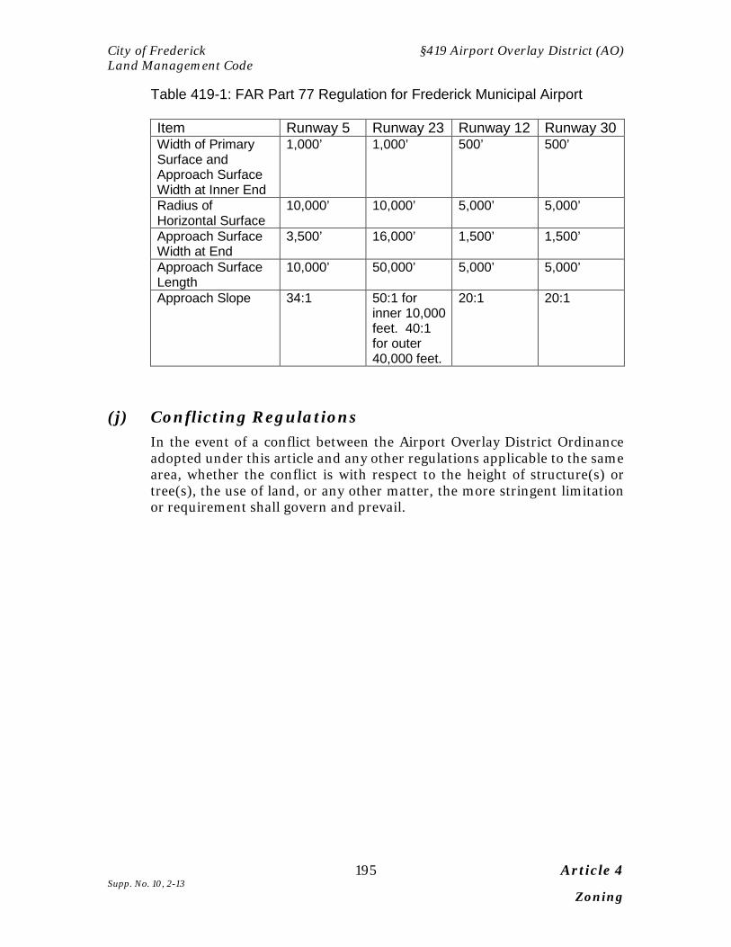
City of Frederick §419 Airport Overlay District (AO) Land Management Code
195 Article 4 Supp. No. 10, 2-13 Zoning
Table 419-1: FAR Part 77 Regulation for Frederick Municipal Airport
Item Runway 5 Runway 23 Runway 12 Runway 30 Width of Primary Surface and Approach Surface Width at Inner End
1,000’ 1,000’ 500’ 500’
Radius of Horizontal Surface
10,000’ 10,000’ 5,000’ 5,000’
Approach Surface Width at End
3,500’ 16,000’ 1,500’ 1,500’
Approach Surface Length
10,000’ 50,000’ 5,000’ 5,000’
Approach Slope 34:1 50:1 for inner 10,000 feet. 40:1 for outer 40,000 feet.
20:1 20:1
(j) Conflicting Regulations
In the event of a conflict between the Airport Overlay District Ordinance adopted under this article and any other regulations applicable to the same area, whether the conflict is with respect to the height of structure(s) or tree(s), the use of land, or any other matter, the more stringent limitation or requirement shall govern and prevail.

§419 Airport Overlay District (AO) City of Frederick Land Management Code
Article 4 196 Zoning Supp. No. 10, 2-13
Pages 196 – 200 Reserved

City of Frederick §420 Carroll Creek Overlay District Land Management Code
197 Article 4 Supp. No. 10, 2-13 Zoning
17, 27,28Sec. 420 CARROLL CREEK OVERLAY DISTRICT [CONTENTS OF CARROLL CREEK OVERLAY DISTRICT WILL BE INSERTED HERE]
Sec. 421 CORRIDOR OVERLAY DISTRICT (COD) [RESERVED]

§423 Historic Preservation Overlay (HPO) District City of Frederick Land Management Code
Article 4 198 Zoning Supp. No. 10, 2-13
This Page Left Intentionally Blank
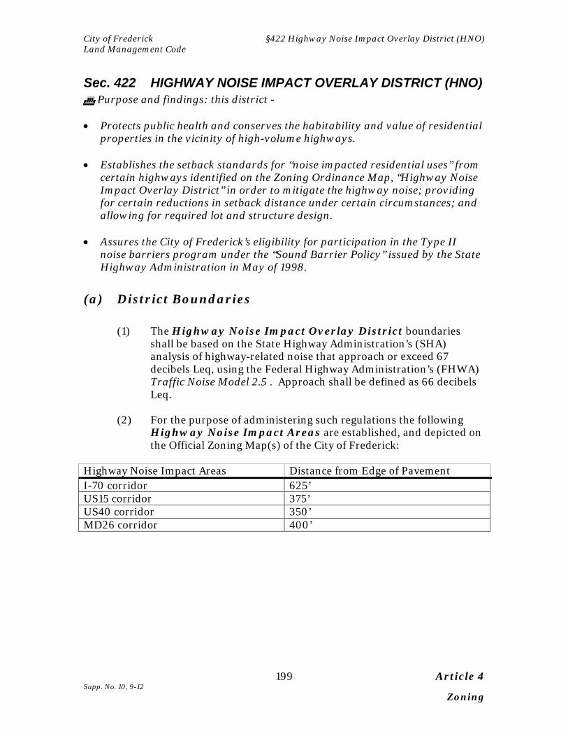
City of Frederick §422 Highway Noise Impact Overlay District (HNO) Land Management Code
199 Article 4 Supp. No. 10, 9-12 Zoning
Sec. 422 HIGHWAY NOISE IMPACT OVERLAY DISTRICT (HNO) Purpose and findings: this district - • Protects public health and conserves the habitability and value of residential
properties in the vicinity of high-volume highways. • Establishes the setback standards for “noise impacted residential uses” from
certain highways identified on the Zoning Ordinance Map, “Highway Noise Impact Overlay District” in order to mitigate the highway noise; providing for certain reductions in setback distance under certain circumstances; and allowing for required lot and structure design.
• Assures the City of Frederick’s eligibility for participation in the Type II
noise barriers program under the “Sound Barrier Policy” issued by the State Highway Administration in May of 1998.
(a) District Boundaries
(1) The Highway Noise Impact Overlay District boundaries shall be based on the State Highway Administration’s (SHA) analysis of highway-related noise that approach or exceed 67 decibels Leq, using the Federal Highway Administration’s (FHWA) Traffic Noise Model 2.5 . Approach shall be defined as 66 decibels Leq.
(2) For the purpose of administering such regulations the following
Highway Noise Impact Areas are established, and depicted on the Official Zoning Map(s) of the City of Frederick:
Highway Noise Impact Areas Distance from Edge of Pavement I-70 corridor 625’ US15 corridor 375’ US40 corridor 350’ MD26 corridor 400’

§423 Historic Preservation Overlay (HPO) District City of Frederick Land Management Code
Article 4 200 Zoning Supp. No. 10, 2-13
(b) Overlay District Established The Highway Noise Impact Overlay District is established as an overlay district. Land within the Highway Noise Impact Overlay District may be used as permitted in the underlying district only if and to the extent such use is also permitted in the overlay district and subject to the additional overlay regulations. Infill developments on lots three (3) acres in size or less recorded prior to August 15, 2005 shall be exempt from the provisions of Section 422.
(c) Use Limitations In addition to the use limitations and regulations for the zoning district over which the Highway Noise Impact Overlay District is located, the use limitations in subsections (d) through (e) shall apply.
(d) For Residential Areas The developer of any “noise impacted residential uses” shall subdivide and/or construct in accordance with one of the following alternatives: (1) For all new residential subdivisions, as of August 15, 2005, no
residential single-family detached or townhouse lots are to be created within the Highway Noise Impact Overlay District, and all residential lands within the Highway Noise Impact Overlay District are dedicated to homeowners association for open space purposes. Not withstanding the above, if the applicant proposes to construct within the prescribed distances of Subsection (a), the provisions of Subsection (d)(4) must be followed.
(2) For all new residential subdivisions of multifamily housing, as of
August 15, 2005, all noise sensitive use areas within a “Noise Impacted Residential Use” that experience frequent human usage shall have the placement of the multifamily residential structures setback from the designated highways as prescribed in Subsection (a). Not withstanding the above, if the applicant proposes to construct within the prescribed distances of Subsection (a), the provisions of Subsection (d)(4) must be followed.
City of Frederick §422 Highway Noise Impact Overlay District (HNO) Land Management Code
201 Article 4 Supp. No. 10, 9-12 Zoning
(3) For all existing residential lots and approved preliminary subdivisions as of August 15, 2005, all noise sensitive use areas within a “Noise Impacted Residential Use” that used on a daily basis shall have the placement of the residential structure setback from the designated highways as prescribed in subsection (a), but may be modified by the Planning Commission if determined to not reasonably be possible. If applicant proposed to construct within the prescribed distances of subsection (a), the provisions of subsection (4) must be followed.
(4) Noise Impact Analysis and Mitigation
A. A noise impact study shall be conducted by a demonstrated qualified acoustical engineer with experience in highway noise analysis to determine the worst case decibel level based upon highway capacity Level of Service “D”, at noise sensitive use areas using FHWA documentation: “Measurement of Highway Related Noise” Final Report, May 1996. The State Highway Administration will provide the City with advice on the technical accuracy of noise impact studies.
B. The setback established in subsection (a) may be reduced by
the Planning Commission during the subdivision and site plan review process, if it is determined that the noise impact setback distance needed to maintain traffic noise levels lower than 66 decibels in areas of the property that are noise sensitive. If at that time, the applicant can construct the proposed residential structure(s) outside the 66 decibel area, then no further mitigation is necessary and approval of the subdivision or site plan can proceed with no HNO restriction (for the relevant areas of the subject parcel(s).
C. If it is determined that highway noise mitigation measures
are proposed to address the impact of highway noise on residential uses, and to insure reduced noise impact, the Planning Commission may approve a preliminary or final subdivision plat or a final site plan with the condition of implementing noise mitigation measures to reduce the decibel levels as follows:
1. For single-family homes at the residential lot line a
projected level of 63 decibels shall be required. 2. For townhouse homes at the residential lot line a
projected level of 65 decibels shall be required.
§423 Historic Preservation Overlay (HPO) District City of Frederick Land Management Code
Article 4 202 Zoning Supp. No. 10, 2-13
3. For multifamily development at the proposed building footprint a projected level of 65 decibels shall be required. In the case of proposed multifamily on existing recorded lots, if it can be demonstrated by the applicant that noise mitigation cannot be reasonably implemented to reduce levels to 65 decibels at the building footprint, then alternative construction measures may be approved as mitigation measures to achieve interior noise levels of 45 decibels. Prior to issuance of the Certificate of Use and Occupancy, verification of the acoustical treatment to achieve the 45 decibels shall be conducted through field testing, certified by an acoustical engineer.
(e) Acoustical Treatment The developer of any residential use that is within the Highway Noise Impact Overlay District shall incorporate acoustical treatment into all dwelling units to insure that interior noise levels within living spaces (not including garages, sun rooms, or porches) do not exceed a sound level of 45 decibels dBA (Leq). Prior to issuance of the Certificate of Use and Occupancy, verification of the acoustical treatment to achieve the 45 decibels shall be conducted through field testing, certified by an acoustical engineer.
City of Frederick §423 Historic Preservation Overlay (HPO) District Land Management Code
257 Article 4 Supp. No. 10, 2-13 Zoning
33, 40 Sec 423 HISTORIC PRESERVATION OVERLAY (HPO) DISTRICT
Purpose: The preservation of sites, structures, and districts of historical, archeological, or architectural significance and their appurtenances and environmental settings is a public purpose in the City. This section is designed to safeguard the historical and cultural heritage of The City of Frederick by preserving sites, structures or districts that reflect elements of cultural, social, economic, political, archeological, or architectural history; to stabilize and improve property values of those sites, structures, or districts; to foster civic beauty; to strengthen the local economy; and to promote the preservation and appreciation of those sites, structures, and districts for the education and welfare of the residents of the City.
(a) Authority:
The Mayor and Board of Aldermen derive authority for this section by virtue of its conformance with provisions of the State of Maryland Enabling Act for Historic Area Zoning (Article 66B, Section 8.01 - 8.17, Annotated Code of Maryland, as amended).
35 (b) Overlay District Established:
This section 423 applies to any site or structure located within a historic preservation overlay zone, as depicted on the Official Zoning Map, as of or after the effective date of this ordinance. Sites and structures within a historic preservation overlay zone may be used as permitted in the base zoning district but are also subject to the additional regulations set forth in this section 423.
(c) Designation of Sites, Structures, or Districts:
(1) Authority. Pursuant to the Annotated Code of Maryland, Article 66B, § 8.02, the Board of Aldermen may designate boundaries for sites, structures, or districts that are deemed to be of historic, archeological, or architectural significance by following the procedures of the City for establishing or changing areas and classifications of zoning. The designation of a site, structure, or
§423 Historic Preservation Overlay (HPO) District City of Frederick Land Management Code
Article 4 258 Zoning Supp. No. 10, 2-13
district constitutes an amendment to the Official Zoning Map through the creation of a historic preservation overlay zone.
(2) Criteria for Designation. A site, structure, or district is eligible
for designation if it is at least 50 years old and meets one or more of the following criteria:
A. The site, structure, or district is associated with events and
cultural groups that have made a significant contribution to the broad patterns of history, including those that exemplify the heritage of the City;
B. The site, structure, or district is associated with the lives of
persons significant in the history of the City, the region, the state, or the nation;
C. The site, structure, or district yields, or may be likely to yield
information important in prehistory or history; or D. The site, structure, or district exhibits significance in design
or construction by:
(i) Embodying the distinctive characteristics of a type, period or method of construction, including characteristics particularly associated with the City;
(ii) Representing the work of a master; (iii) Possessing high artistic values or superior
craftsmanship; or (iv) Representing a distinguishable entity, such as an
historic district or complex of resources, whose components may lack individual distinction.
(3) Designation Process.
A. Application.
(i) Site or Structure – Who May Apply. An
application for the designation of a site or structure of historic, archeological, or architectural significance may be made by:
(a) Any elected City official; (b) The Commission;

City of Frederick §423 Historic Preservation Overlay (HPO) District Land Management Code
259 Article 4 Supp. No. 10, 2-13 Zoning
(c) The Department; (d) The owner of the site or structure, or an
authorized agent of the owner; or (e) Any person or persons with at least a 50
percent contractual or proprietary interest in the site or structure.
(ii) District – Who May Apply. An application to
designate a district of historic, archeological, or architectural significance may be made by:
(a) Any elected City official; (b) The Commission; (c) The Department; or (d) The owners of 50 percent or more of the lots
within the proposed district, with each lot having one vote.
B. Historic Preservation Commission Hearing and
Recommendation.
(i) Upon receipt of an application for designation, the Department shall set a date for a public hearing by the Commission within 30 days of the submittal of the application, following the notice provisions of § 301 of this Code.
(ii) The Commission shall hold a public hearing at which
any interested person will have the right to appear and be heard. The Commission may order a continuance of the hearing for a specified reason to a specific date, time and place.
(iii) Within 45 days of the closing of the public hearing,
unless such time is extended by the Commission for a specified reason, the Commission shall: (a) Adopt a resolution setting forth its findings of fact and recommending the approval, denial, or modification of the proposed designation; and (b) Forward its resolution to the Planning Commission. In making its
§423 Historic Preservation Overlay (HPO) District City of Frederick Land Management Code
Article 4 260 Zoning Supp. No. 10, 2-13
recommendation, the Commission shall use only the criteria established in 423 (c)(2).
C. Planning Commission Hearing and
Recommendation. Within 45 days of its receipt of the Commission's resolution, the Planning Commission shall hold a public hearing at which any interested person will have the right to appear and be heard. Within 45 days of the closing of the public hearing, unless such time is extended by the Planning Commission for a specified reason, the Planning Commission shall: (a) Adopt a resolution setting forth its findings of fact and recommending the approval, denial, or modification of the proposed designation; and (b) Forward its resolution to the Mayor and Board of Aldermen. In making its recommendation, the Planning Commission shall consider the Commission's findings with regard to the criteria established in § 423(c)(2). The Planning Commission shall also evaluate the potential designation for consistency with the comprehensive plan, and may consider any other planning issues.
D. Board of Aldermen Hearing and Decision. Following
its receipt of the resolution of the Planning Commission, the Board of Aldermen shall hold a public hearing and take action in accordance with § 306(b) and 306 (d) of this Code. In deciding whether to designate a site, structure, or district, the Board of Aldermen shall consider the findings and recommendations of the Commission and the Planning Commission.
(d) Application for Certificate of Approval and
Commission Review of Applications, In General:
(1) Applicability. A. Certificate of Approval Required. Before
constructing, altering, reconstructing, moving, or demolishing any site or structure, a person shall submit an application in accordance with § 1124 of this LMC and obtain a certificate of approval from the Commission if:
(i) The Commission has jurisdiction over the site
or structure; and

City of Frederick §423 Historic Preservation Overlay (HPO) District Land Management Code
261 Article 4 Supp. No. 10, 2-13 Zoning
(ii) Any exterior change is involved that is not routine maintenance.
B. Jurisdiction of the Commission.
(i) The Commission has jurisdiction over every
site or structure located in a historic preservation overlay zone, if any portion of the site or structure is visible or intended to be visible from a public way.
(ii) A proposed change to a site or structure need
not be visible or intended to be visible from a public way in order to be subject to review by the Commission.
(iii) The Commission has jurisdiction over exterior
features of a structure and shall not consider any interior arrangement. Exterior features include, but are not limited to: (a) Any sign or other treatment applied directly to a window; and (b) Any sign that is placed within a window or otherwise intended to be viewed from the exterior.
(2) Commission Action. Every application submitted in
accordance with § 423(d)(1) shall be considered by the Commission and approved, approved with conditions, or denied by the Commission.
(3) Review of Applications.
A. Guidelines. The Board of Aldermen shall adopt
guidelines for rehabilitation and new construction design for designated sites, structures, and districts that are generally consistent with those recognized by the Maryland Historical Trust. The Commission shall use the guidelines in its review of applications.
B. General Considerations. In reviewing
applications, the Commission shall consider the factors set forth in this § 423(d)(3)(B). The Commission may not deny an application except as based on the considerations set forth in this §423(d)(3)(B).

§423 Historic Preservation Overlay (HPO) District City of Frederick Land Management Code
Article 4 262 Zoning Supp. No. 10, 2-13
(i) The historic, archeological, or architectural significance of the site or structure and its relationship to the historic, archeological, or architectural significance of the surrounding area;
(ii) The relationship of the exterior architectural
features of a structure to the remainder of the structure and to the surrounding area;
(iii) The general compatibility of exterior design,
scale, proportion, arrangement, texture and materials to the site or structure and to the surrounding area; and
(iv) Any other factors, including aesthetic factors,
that the Commission considers pertinent.
C. Strict Judgment. The Commission shall strictly judge plans for sites or structures determined by research to be of historic, archeological, or architectural significance. Unless the plans would seriously impair the historic, archeological, or architectural significance of the surrounding site or structure, the Commission shall not strictly judge plans for sites or structures of little historic, archeological or architectural significance or plans involving new construction.
D. Limiting Architectural Style. The Commission is
not required to limit construction, reconstruction or alteration to the architectural style of any one period.
(4) Certificate of Approval, Approval With Conditions,
or Denial.
A. Certificate to be Filed. The Commission shall file with the Building Department a certificate of approval, approval with conditions, or denial of each application submitted to it for review.
B. Building Permits. The Building Department may
not issue a building permit for a project until the Building Department has received a certificate of approval. Work may not be commenced on any project until a certificate of approval has been filed and all other applicable requirements have been met.

City of Frederick §423 Historic Preservation Overlay (HPO) District Land Management Code
263 Article 4 Supp. No. 10, 2-13 Zoning
C. Failure to Act on Application. The failure of the
Commission to act upon a completed application within 45 days from the date the application is deemed complete constitutes automatic approval of the application unless the applicant and the Commission agree to an extension of the 45 day period or the application is withdrawn.
D. Resubmittal. An application that is substantially
the same as a denied application may not be resubmitted within a period of one year after the denial.
(5) Routine Maintenance. Nothing in this article shall be construed
to prevent routine maintenance, customary farming operations, or landscaping that has no material effect on the historic, archeological, or architectural significance of a site, structure or district located within a historic preservation overlay zone.
(e) Demolition.
(1) Procedures. In making a decision on a demolition application, the Commission may use a multi-hearing process as further described in this paragraph.
A. Degree of Significance. At the first hearing, the
Commission shall determine whether the site or structure is “noncontributing” or contributing” based on the criteria established in the Commission's guidelines.
B. Approval or Denial of Demolition Request.
(i) Noncontributing. If the Commission
determines that a site or structure is noncontributing, the Commission may take action on the demolition request at the same hearing. In making its decision, the Commission shall use the applicable criteria in Commission’s guidelines. The Commission may also take action on any replacement plans at the same hearing.
(ii) Contributing. If the Commission determines
that a site or structure is contributing, the Commission may not vote on the demolition
§423 Historic Preservation Overlay (HPO) District City of Frederick Land Management Code
Article 4 264 Zoning Supp. No. 10, 2-13
request until a subsequent hearing. In making its decision, the Commission shall use the applicable criteria in the Commission’s guidelines.
(2) Demolition by Neglect.
In the event of demolition by neglect, the Commission may request that the appropriate department of the City initiate enforcement action against any appropriate defendant in accordance with the Property Maintenance Code or other applicable City law.
C. Replacement Plans. An application for demolition of a site or structure shall include a replacement plan. Approval for the demolition of a site or structure may be conditioned upon the approval of an acceptable replacement plan. A bond or other financial guaranty in the amount of the cost of the replacement structure may be required in order to assure the completion of the replacement plan.
(f) New Construction:
(1) Applicability. This section 423(f) applies to any new construction (in a historic preservation overlay zone) for which a site plan is required pursuant to § 309 of this Code.
(2) Phased Review. The Commission will review applications
for new construction projects in two phases, which will be known as "Level I" and "Level II". A separate application is required for each phase.
A. Level I.
(i) During Level I review, the Commission will
consider the following aspects of any proposed new construction project, using the criteria established in the Commission's guidelines:
(a) Location; (b) Footprint; (c) Massing; (d) Height;

City of Frederick §423 Historic Preservation Overlay (HPO) District Land Management Code
265 Article 4 Supp. No. 10, 2-13 Zoning
(e) Setback; (f) Scale; (g) Façade; (h) Roof forms; (i) Materials; and (j) Plot plan.
(ii) After the Commission reviews those aspects of the project set forth in § 423(f)(2)(A)(i), it may issue a Level I certificate of approval.
B. Site Plan. The applicant shall obtain conditional or
unconditional final site plan approval after the Commission issues a Level I certificate of approval and before the Commission commences Level II review of a new construction project.
C. Level II.
(i) During Level II review, the Commission will consider the following aspects of any proposed new construction project, using the criteria established in the Commission's guidelines:
(a) Texture; (b) Openings; (c) Lighting; (d) Landscaping; (e) Site plan; (f) Final articulation; (g) Detailed façade and elevations; and (h) Fenestration.
§423 Historic Preservation Overlay (HPO) District City of Frederick Land Management Code
Article 4 266 Zoning Supp. No. 10, 2-13
(ii) After the Commission reviews those aspects of the project set forth in § 423(f)(2)(B)(i), it may issue a Level II certificate of approval.
(g) Sites and Structures of Unusual Importance.
(1) Definition. For purposes of this subsection, a site or structure of "unusual importance" is a contributing site or structure that individually meets one or more of the criteria for designation set forth in subsection (c)(2) of this section.
(2) Plan to Preserve Site or Structure.
A. If an application is submitted for construction, reconstruction or alteration, moving, or demolition of a site or structure of unusual importance, the Commission shall attempt to formulate an economically feasible plan with the owner of the site or structure for its preservation.
B. If no economically feasible plan can be formulated,
the Commission shall have 90 days from the time it concludes that no economically feasible plan can be formulated to negotiate with the owner and other parties in an effort to find a means of preserving the site or structure.
(3) Action on Application.
A. Denial. Except as otherwise provided in
subparagraph (B) of this paragraph, unless the Commission is satisfied that the proposed construction, reconstruction or alteration will not materially impair the historic, archeological or architectural significance of the site or structure, the Commission shall deny the application for construction, reconstruction or alteration.
B. Approval. The Commission may approve the
proposed construction, reconstruction, alteration, moving or demolition if:
(i) The structure is a deterrent to a major
improvement program that will be of substantial benefit to the City;
City of Frederick §423 Historic Preservation Overlay (HPO) District Land Management Code
267 Article 4 Supp. No. 10, 2-13 Zoning
(ii) Retention of the structure would cause undue financial hardship to the owner; or
(iii) Retention of the structure would not be in the
best interests of a majority of persons in the City.
(h) Certificate of Approval Expiration.
(1) If a building permit or zoning permit has not been issued for the
project within three years after the certificate of approval is issued for that project, the certificate of approval will become void.
(2) If a building permit or zoning permit is not issued for the project within three years due to government constraints such as insufficient water or sewer to construct the project, the period for which the government constraint persists will not be included in calculating the expiration date of the certificate of approval.
(3) If a building permit or zoning permit has not been issued for the project such that the certificate of approval will expire, a six month extension may be granted by the Department upon request of the owner or applicant. Further extensions may be granted by the Commission.
(i) Maryland Historical Trust: The Commission may designate the Maryland Historical Trust or a private qualified historic preservation consultant to conduct an analysis of, report on, or recommend the preservation of sites, structures, or districts of historic, archeological, architectural, or cultural significance within the City. The report may include proposed boundaries of sites, structures, or districts, as well as recommendations for the identification and designation of particular sites, structures, or districts to be preserved.
(j) Appeals: Any person aggrieved by a decision of the Commission may,
within 30 days of the decision, file a petition for judicial review in the Circuit Court for Frederick County in accordance with the Maryland Rules applicable to judicial review of administrative agency decisions.
§423 Historic Preservation Overlay (HPO) District City of Frederick Land Management Code
Article 4 268 Zoning Supp. No. 10, 2-13
End Notes: 1 Supp. No. 1, Ord. No. G-05-13, § 1, 9-15-05 10 Supp. No. 3, Ord. No. G-06-26, § 7, 9-7-06 2 Supp. No. 1, Ord. No. G-05-13, § 2, 9-15-05 11 Supp. No. 3, Ord. No. G-06-5, § 1, 4-6-06; Ord. No. G-06-6, § 1, 4-6-06; Ord. No. G-06-7, § 1,
4-6-06; Ord. No. G-06-8, § 1, 4-6-06; Ord. No. G-06-9, § 1, 4-6-06; Ord. No. G-06-10, § 1, 4-6-06; Ord. No. G-06-17, § 1, 6-1-06; Ord. No. G-06-18, § 1, 6-1-06; Ord. No. G-06-19, § 1, 4-6-06; Ord. No. G-06-20, § 1, 7-6-06
3 Supp. No. 1, Ord. No. G-05-13, § 3, 9-15-05 12 Supp. No. 3, Ord. No. G-06-29, § 1, 9-7-06 19 Supp. No, 4, Ord. No. G-07-3, § 1, 1-4-07 23 Supp. No, 5, Ord. No. G-07-22, § 4, 10-18-07 29 Supp. No, 7, Ord. No. G-08-10, § 4, 6-5-08 30 Supp. No, 7, Ord. No. G-08-11, § 2, 6-5-08 4 Supp. No. 1, Ord. No. G-05-13, § 4, 9-15-05 24 Supp. No, 5, Ord. No. G-07-22, § 5, 10-18-07 8 Supp. No. 2, Ord. No. G-05-17, § 2, 12-19-05 5 Supp. No. 1, Ord. No. G-05-13, § 5, 9-15-05 31 Supp. No. 8, Ord. No. G-08-21, §3, 12-18-09 32 Supp. No. 8, Ord. No. G-09-18, §1, 12-14-09 9 Supp. No. 2, Ord. No. G-05-17, § 3, 12-19-05 25 Supp. No, 5, Ord. No. G-07-22, § 6, 10-18-07 13 Supp. No. 3, Ord. No. G-06-25, § 1, 9-7-06 14 Supp. No. 3, Ord. No. G-06-26, § 8, 9-7-06 26 Supp. No, 5, Ord. No. G-07-22, § 7, 10-18-07 6 Supp. No. 1, Ord. No. G-05-15, § 6, 9-15-05 7 Supp. No. 1, Ord. No. G-05-15, § 7, 9-15-05 20 Supp. No. 9, Ord. No. G-10-03, §1, 4-11-10; as previously amended under Supp. No, 4, Ord. No. G-07-3, § 2, 1-4-07 18 Supp. No. 9, Ord. No. G-10-03, § 2, 4-11-10 as previously amended in Suppl. No. 3 Ord. No. G-06-26, §9, 9-7-06 and Suppl. No. 4. Ord. No G-07-3, §3, 1-4-07 34 Supp. No. 9, Ord. No. G-10-03, §3, 4-11-10 as previously amended under Supp. No, 4, Ord. No. G-07-3, § 4, 1-4-07 22 Supp. No. 10, Ord. No., G-11-12, § 1, 5-27-12 36 Supp. No. 10, Ord. No., G-11-14, § 1, 6-26-11 17 Supp. No. 3, Ord. No. G-06-21, § 1, 7-6-06 27 Supp. No, 5, Ord. No. G-07-22, § 8- 10, 10-18-07 28 Supp. No. 6, Ord, No. G-08-4, § 1, 2-7-08 33 Supp. No. 8, Ord. No. G-09-21, § 3, 12-14-09; as previously amended under Supp. No. 3, Ord. No. G-06-26, §11, 9-7-06 35 Supp. No. 9., Ord. No. G-10-15, § 2, 8-15-10 37 Supp. No. 10, Ord. No. G-12-12, § 1, 5-27-12 38 Supp. No. 10, Ord. No. G-12-19, § 1, 7-29-12 39 Supp. No. 10, Ord. No. G-12-18, § 1, 7-29-12 40 Supp. No. 10, Ord. No. G-12-17, § 1, 7-29-12

City of Frederick §423 Historic Preservation Overlay (HPO) District Land Management Code
269 Article 4 Supp. No. 10, 2-13 Zoning
Pages 269-300 RESERVED
§423 Historic Preservation Overlay (HPO) District City of Frederick Land Management Code
Article 4 270 Zoning Supp. No. 10, 2-13
THIS PAGE INTENTIONALLY LEFT BLANK