Embed Size (px)
Citation preview
Warren County Joint Zoning Ordinance -----------------------------------------------------------
3-1
ARTICLE 3 DEVELOPMENT REVIEW PROCEDURES
SEC. 3.1 GENERAL
3.1.1 Application Forms Every application for development approval shall be in a form specified by the Planning
Commission.
3.1.2 Standard Application Submission Cycle Applications that will be reviewed by the City-County Planning Commission or the City-County
Board of Adjustments shall be filed at least 28 days in advance of the scheduled public hearing, in order to allow adequate time for staff review and preparation of a staff report. Complex applications, such as map amendments, may require additional review time.
3.1.3 Application Fees
A. No application shall be accepted by the Planning Commission until the established fee has been paid. This nonrefundable fee may be adjusted periodically by the Planning Commission to defray the actual cost of processing the application and providing public notice.
B. No application fee shall be required when a text or map amendment is being proposed by the City-County Planning Commission or any member government.
3.1.4 Traffic Impact Study.
A. Any development requiring the submission of a Traffic Impact Study, as triggered by the thresholds identified by the Bowling Green Public Works Department (BGPW), Warren County Public Works Department (WCPW) or the Kentucky Transportation Cabinet (KYTC), shall analyze the effect of the proposed project on the surrounding roadways and intersections. Such effect shall be measured against the existing level of service standard and circulation patterns for the roadways affected by the proposed development’s impact.
B. Exceptions to this requirement may be approved after consultation between the applicant and affected agencies (BGPW, WCPW and/or KYTC). When a project’s traffic impact can be clearly anticipated without a study and all of the parties involved (transportation agency(ies) and applicant) are able to negotiate appropriate mitigation, a TIS may not be necessary. The applicant must provide documentation, in writing, from all affected agencies, exempting their particular development from the TIS requirement, along with a commitment in the form of a development plan condition(s), or conditions(s) in the instance of a CUP, agreeing to all improvement(s) required by such agency(ies). This documentation must be submitted as a part of an application (Zoning Map Amendment, Amendment to Development Plan Conditions, FLUM Amendment, Conditional Use Permit, Site Development Plan), in order for the application to be deemed complete.
3.1.5 Completeness of Application No application shall be processed until it has been deemed complete by the Director. The
Director shall have 5 working days following the submission of an application to determine its completeness. The Planning Commission staff will notify the applicant(s) of any deficiencies in the application. The application shall not be scheduled for a public hearing until all deficiencies are addressed.
Warren County Joint Zoning Ordinance -----------------------------------------------------------
3-2
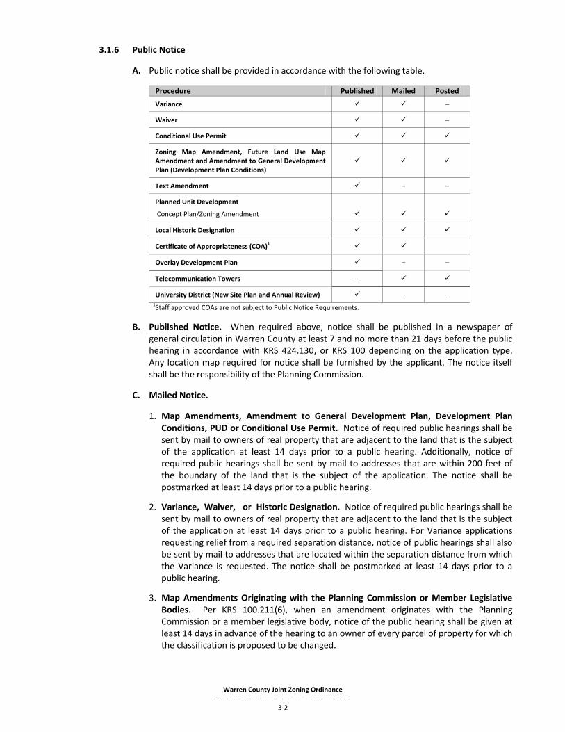
3.1.6 Public Notice
A. Public notice shall be provided in accordance with the following table.
Procedure Published Mailed Posted
Variance –
Waiver –
Conditional Use Permit
Zoning Map Amendment, Future Land Use Map Amendment and Amendment to General Development Plan (Development Plan Conditions)
Text Amendment – –
Planned Unit Development
Concept Plan/Zoning Amendment
Local Historic Designation
Certificate of Appropriateness (COA)1
Overlay Development Plan – –
Telecommunication Towers –
University District (New Site Plan and Annual Review) – – 1Staff approved COAs are not subject to Public Notice Requirements.
B. Published Notice. When required above, notice shall be published in a newspaper of general circulation in Warren County at least 7 and no more than 21 days before the public hearing in accordance with KRS 424.130, or KRS 100 depending on the application type. Any location map required for notice shall be furnished by the applicant. The notice itself shall be the responsibility of the Planning Commission.
C. Mailed Notice.
1. Map Amendments, Amendment to General Development Plan, Development Plan Conditions, PUD or Conditional Use Permit. Notice of required public hearings shall be sent by mail to owners of real property that are adjacent to the land that is the subject of the application at least 14 days prior to a public hearing. Additionally, notice of required public hearings shall be sent by mail to addresses that are within 200 feet of the boundary of the land that is the subject of the application. The notice shall be postmarked at least 14 days prior to a public hearing.
2. Variance, Waiver, or Historic Designation. Notice of required public hearings shall be sent by mail to owners of real property that are adjacent to the land that is the subject of the application at least 14 days prior to a public hearing. For Variance applications requesting relief from a required separation distance, notice of public hearings shall also be sent by mail to addresses that are located within the separation distance from which the Variance is requested. The notice shall be postmarked at least 14 days prior to a public hearing.
3. Map Amendments Originating with the Planning Commission or Member Legislative Bodies. Per KRS 100.211(6), when an amendment originates with the Planning Commission or a member legislative body, notice of the public hearing shall be given at least 14 days in advance of the hearing to an owner of every parcel of property for which the classification is proposed to be changed.

Warren County Joint Zoning Ordinance -----------------------------------------------------------
3-3
4. Appeals. When required above, notice of required public hearings shall be sent by mail to owners of real property that are adjacent to the land that is the subject of the application at least 14 days prior to a public hearing.
5. Telecommunication Towers. Notice of required public hearings shall be sent by mail to
owners of real property contiguous to the property upon which the construction is proposed or owners of real property within 500 feet of the proposed tower. For additional mailing requirements by the applicants for a Telecommunications Tower, see Section 3.20.3.L of this Ordinance.
6. Owners of real property shall be identified by reference to the most recent tax records
and shall be provided to the Planning Commission by the applicant. Records maintained by the property valuation administrator may be relied upon exclusively to determine the identity and address of said owner. In the event such property is in condominium or cooperative forms of ownership, then the person notified by mail shall be the president or chairperson of the owner group which administers property commonly owned by the condominium or cooperative owners.
7. Mailing of required notice shall be the responsibility of the Planning Commission. Proof
of mailing shall include:
a. A copy of the notice letter; and b. The property valuation administrators list of affected owners.
8. Notice shall be deemed mailed by virtue of its deposit with the United States Postal
Service, properly addressed with postage prepaid. D. Content of Published or Mailed Notice. Published or mailed notices shall provide at least
the following information:
1. A map of the general location of the land that is the subject of the application (mailed notice only);
2. A summary of the subject property’s legal description or a street address per KRS 100.211(3);
3. The substance of the application;
4. The time, date and location of the public hearing; and
5. The Planning Commission’s telephone number. E. Posted Notice. When required above, notice of the public hearing shall be posted
conspicuously on the subject property for 14 consecutive days immediately prior to the hearing. The posting of the notice shall be the responsibility of the Planning Commission. Posted notice shall contain:
1. The substance of the application;
2. The time, date and location of the public hearing; and
3. The Planning Commission’s telephone number.
Warren County Joint Zoning Ordinance -----------------------------------------------------------
3-4
3.1.7 Public Hearing
A. The property owner and contract vendee must attend the public hearing or be represented by an attorney at the hearing.
B. Any exhibit (including electronic presentation materials) intended for presentation before the Planning Commission or Board of Adjustments shall be provided to the Planning Commission in an electronic and/or scannable format.
3.1.8 Continuation of Public Hearings A public hearing for which proper notice was given may be continued to a later date by majority
vote of the Planning Commission, Board of Adjustments, Historic Preservation Board, Urban Growth Design Review Board or University District Review Board without complying with the notice provisions above provided that the continuance is set for a date and time certain announced at the public hearing.
3.1.9 Withdrawal of Application Any application may be withdrawn prior to final action by the legislative body. No fee shall be
returned or credited for such a withdrawal.
3.1.10 Time Limit for Reapplication The Planning Commission shall not consider, unless initiated by the Planning Commission Staff,
a parcel of land, or any portion thereof, for Official Zoning Map amendment, including amendment of development plan conditions of a development or a Future Land Use Map amendment, until 12 consecutive months shall have elapsed from any final action as defined in Sec. 3.1.13 below upon any application for such Official Zoning Map amendment. Re-applications initiated by the Planning Commission shall be based on a change of circumstance which were not known at the time of the original application.
3.1.11 Construction Initiation The Planning Commission shall require that substantial construction be initiated within 5 years
of the date of any final action upon the Official Zoning Map amendment as defined in Sec. 3.1.13 below. If such construction is not initiated within the said 5 year period, the Planning Commission may initiate an application to revert the Official Zoning Map designation to its previous designation. Any action to revert the Official Zoning Map amendment to its previous zoning classification which originates as a result of the provisions of this section of the Ordinance shall be taken in the same manner as any other Official Zoning Map amendment. Failure of the Planning Commission to commence action to revert the Official Zoning Map classification immediately after 5 years shall not prevent the Commission from taking such action at a later date.
3.1.12 Time Limit for Rehearing before Board of Adjustments The Board of Adjustments shall not consider, unless initiated by the Planning Commission Staff,
a parcel of land or any portion thereof for any variance, waiver, conditional use permit or appeal from any administrative official until 12 consecutive months shall have elapsed from any final action as defined in Sec. 3.1.13 below upon any application for such variance, conditional use permit or appeal from any administrative official. Re-applications initiated by the Planning Commission shall be based on a change of circumstance which were not known at the time of the original application.
3.1.13 Final Action For purposes of this Ordinance, "Final Action" shall be defined as any final adjudication of the
application for any:
A. Zoning Map amendment or text amendment by the Legislative Body;
Warren County Joint Zoning Ordinance -----------------------------------------------------------
3-5
B. Amendment to General Development Plan including Development Plan Conditions or Future Land Use Map (FLUM) amendment by the Planning Commission.
C. Variance, waiver, conditional use permit or appeal from any administrative official before the Board of Adjustments;
D. Variance, wavier or conditional use permit by the Planning Commission;
E. University District Site Plan or Monitoring Plan by the University District Review Board;
F. Certificate of Appropriateness by the Historic Preservation Board;
G. Overlay Development by the Design Review Board; or
H. Site Development Plan by the Executive Director.
I. The appeal from the decision of the Board or Commission to the highest State or Federal court to which any appeals shall be taken.
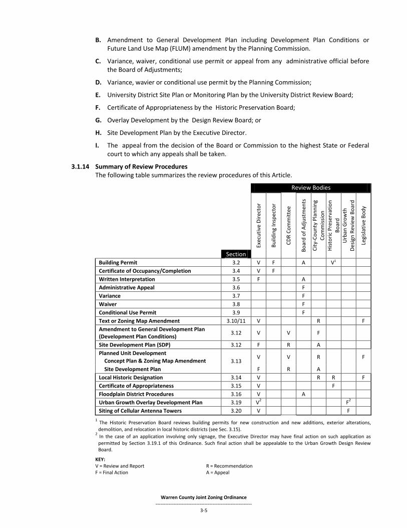
3.1.14 Summary of Review Procedures The following table summarizes the review procedures of this Article.
Review Bodies
Exec
uti
ve D
irec
tor
Bu
ildin
g In
spec
tor
CD
R C
om
mit
tee
Bo
ard
of
Ad
just
men
ts
Cit
y-C
ou
nty
Pla
nn
ing
Co
mm
issi
on
His
tori
c P
rese
rvat
ion
Bo
ard
U
rban
Gro
wth
Des
ign
Rev
iew
Bo
ard
Legi
slat
ive
Bo
dy
Section Building Permit 3.2 V F A V1
Certificate of Occupancy/Completion 3.4 V F
Written Interpretation 3.5 F A
Administrative Appeal 3.6 F
Variance 3.7 F
Waiver 3.8 F
Conditional Use Permit 3.9 F
Text or Zoning Map Amendment 3.10/11 V R F
Amendment to General Development Plan (Development Plan Conditions)
3.12 V V F
Site Development Plan (SDP) 3.12 F R A
Planned Unit Development
Concept Plan & Zoning Map Amendment 3.13 V V R F
Site Development Plan F R A
Local Historic Designation 3.14 V R R F
Certificate of Appropriateness 3.15 V F
Floodplain District Procedures 3.16 V A
Urban Growth Overlay Development Plan 3.19 V2 F
2
Siting of Cellular Antenna Towers 3.20 V F
1 The Historic Preservation Board reviews building permits for new construction and new additions, exterior alterations,
demolition, and relocation in local historic districts (see Sec. 3.15). 2 In the case of an application involving only signage, the Executive Director may have final action on such application as
permitted by Section 3.19.1 of this Ordinance. Such final action shall be appealable to the Urban Growth Design Review Board.
KEY: V = Review and Report R = Recommendation F = Final Action A = Appeal

Warren County Joint Zoning Ordinance -----------------------------------------------------------
3-6
SEC. 3.2 SITE WORK PERMIT AND BUILDING PERMIT It shall be unlawful to begin the construction of any structure or to begin the moving or alteration of any structure or begin or change the use of a premises until the Building Inspector has issued a site work permit (if required by Sec. 3.12.5) and a building permit.
3.2.1 A complete application for a Building Permit shall be submitted to the Building Inspector of the
appropriate agency, along with the appropriate review and inspection fee. Upon determination that the proposed development is in compliance with all requirements, including but not limited to this Ordinance and the adopted building code, the Building Inspector shall issue a building permit.
3.2.2 A building permit application may also include the following items if required by other Sections
of this Ordinance:
A. Landscape Plan (as applicable) - a scaled drawing, including dimensions and distances, existing and proposed buildings, vehicle use areas, driveways, and the location, size, and description of all landscape materials; and,
B. Overlay Development Plan (as applicable) - see Section 3.19.
C. Grading and or Drainage Plan (as applicable).
D. Proof of compliance with General Development Plan and Development Plan Conditions (as applicable).
SEC. 3.3 SITE WORK GRADING PERMIT
Any grading, excavation, filling or removal of soil on any lot or parcel of ground, which significantly affects the permanent drainage characteristics of a site shall require a site work grading permit first being obtained from the appropriate agency and is subject to the requirements in Section 3.12.5. A site work grading permit may be obtained prior to issuance of a site work permit associated with approval of a site development plan.
SEC. 3.4 CERTIFICATES OF OCCUPANCY AND COMPLETION
3.4.1 Applicability No land or structure or part thereof hereafter erected or altered in its use of structure, shall be
used until the Building Inspector has issued a certificate of occupancy and/or certificate of completion. The certificate of occupancy and/or completion shall state that such land, structure, premises or use thereof are found to be in conformity with the provisions of this Ordinance.
3.4.2 Final Inspection
A. After notification that a structure, land or premises is ready for occupancy or use, it shall be
the duty of the Building Inspector code compliance officer and appropriate public works agency to make a final inspection thereof and to issue a certificate of occupancy and/or certificate of completion, if the structure, premises and use thereof are found to conform with the provisions of this Ordinance.
B. Where applicable, the project engineer shall certify the drainage system functions as intended and has been constructed in accordance with any previously submitted plans.
C. Where applicable, the Planning Commission staff shall review any site approved as part of a General Development Plan (Development Plan Conditions), Site Development Plan (SDP) or Overlay Development Plan (ODP), as outlined in this Article to ensure compliance prior to the issuance of a Certificate of Occupancy and/or certificate of completion.
Warren County Joint Zoning Ordinance -----------------------------------------------------------
3-7
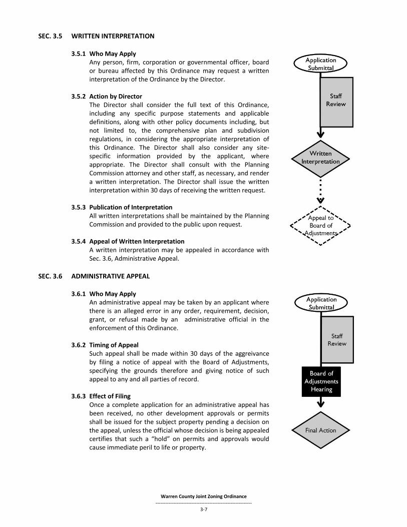
SEC. 3.5 WRITTEN INTERPRETATION
3.5.1 Who May Apply Any person, firm, corporation or governmental officer, board
or bureau affected by this Ordinance may request a written interpretation of the Ordinance by the Director.
3.5.2 Action by Director The Director shall consider the full text of this Ordinance,
including any specific purpose statements and applicable definitions, along with other policy documents including, but not limited to, the comprehensive plan and subdivision regulations, in considering the appropriate interpretation of this Ordinance. The Director shall also consider any site-specific information provided by the applicant, where appropriate. The Director shall consult with the Planning Commission attorney and other staff, as necessary, and render a written interpretation. The Director shall issue the written interpretation within 30 days of receiving the written request.
3.5.3 Publication of Interpretation All written interpretations shall be maintained by the Planning
Commission and provided to the public upon request. 3.5.4 Appeal of Written Interpretation
A written interpretation may be appealed in accordance with Sec. 3.6, Administrative Appeal.
SEC. 3.6 ADMINISTRATIVE APPEAL 3.6.1 Who May Apply
An administrative appeal may be taken by an applicant where there is an alleged error in any order, requirement, decision, grant, or refusal made by an administrative official in the enforcement of this Ordinance.
3.6.2 Timing of Appeal
Such appeal shall be made within 30 days of the aggreivance by filing a notice of appeal with the Board of Adjustments, specifying the grounds therefore and giving notice of such appeal to any and all parties of record.
3.6.3 Effect of Filing
Once a complete application for an administrative appeal has been received, no other development approvals or permits shall be issued for the subject property pending a decision on the appeal, unless the official whose decision is being appealed certifies that such a “hold” on permits and approvals would cause immediate peril to life or property.
Warren County Joint Zoning Ordinance -----------------------------------------------------------
3-8
3.6.4 Required Findings The Board of Adjustments review on appeal shall be limited to a determination of whether or not the decision that is being appealed was (1) based upon substantial evidence and (2) arbitrary and capricious. The Board shall affirm the decision that is being appealed unless one or both of the factors set forth above exists. The Board shall not substitute its judgment for the judgment of the administrative official below.
3.6.5 Action on Appeal
A. The administrative official shall transmit to the Board of Adjustments all papers constituting
the record upon which the action appealed was taken and shall be treated as and be the respondent in such further proceedings.
B. The Board of Adjustments shall fix a reasonable time for the hearing of an appeal.
C. At any hearing by the Board, any interested person may appear and enter their appearance, and all shall be given an opportunity to be heard.
D. Approval of an Administrative Appeal shall require a positive vote from a majority of those members present at a meeting with a properly constituted quorum. An abstaining vote which is cast on any matter before the Board of Adjustments shall have no force or effect and shall not count as a vote with the majority of votes cast.
SEC. 3.7 VARIANCES
3.7.1 Who May Apply The owner of the property in question or an agent for the owner bearing a written power of
attorney granting authority for this purpose may apply for a variance.
3.7.2 Application Requirements All variance applications for relief from horizontal measurements (i.e. setbacks, distances to
nearest neighbor, etc.) shall be accompanied by an accurate boundary survey of the portions of property in question. Variances from dimensional requirements that do not involve horizontal distance measurements (i.e. sign or fence heights) do not require a boundary survey, but must supply an exhibit that clearly illustrates the request. When required, the boundary survey shall be prepared by a surveyor licensed in the State of Kentucky and contain the following information:
1. Owner(s) and applicant(s) names; 2. Scale; 3. Bearings and distances; 4. Locating distance to nearest road or railroad centerline or right-of-way; 5. House number of property or intersecting street on each side; 6. North arrow;
7. Right(s)-of-way of road and pavement width; 8. Adjacent property, showing property lines; 9. Names of adjacent property owner(s);
10. Acreage of property; 11. Vicinity map; 12. Surveyor’s stamp;
13. Floodplain areas(s) and FEMA certification; 14. Location of existing buildings and property boundary lines with new or intended structures
shown by solid lines;
15. Lot coverage; and 16. Proposed grade elevation

Warren County Joint Zoning Ordinance -----------------------------------------------------------
3-9
3.7.3 Permitted Variances
A. The Board of Adjustments shall have the authority to hear and decide applications for a variance from the dimensional terms of this Ordinance pertaining to the height, width, length or location of structures, and the size of yards and open spaces where such departure meets the requirements of KRS 100.241 and 100.247., Only in the following situations shall a variance be granted, and provided that such relief may be granted without substantial detriment to the public good and without substantially impairing the intent and purpose of this Ordinance.
1. Where, by reasons of exceptional narrowness, shallowness or shape of a specific piece of
property, which at the time of the adoption of the ordinance was a lot of record; OR
2. Where, by reason of exceptional topographic conditions or other extraordinary or exceptional situation or condition of a piece of property, the strict application of dimensional requirements would cause practical difficulties to or exceptional and undue hardship upon the owner of such property.
B. Financial disadvantage to the property owner is no proof of hardship within the purpose of
zoning.
3.7.4 Required Findings Before any variance is granted, the board must find that the variance will not adversely affect the public health, safety or welfare, will not alter the essential character of the general vicinity, will not cause a hazard or a nuisance to the public, and will not allow for an unreasonable circumvention of the requirements of the zoning regulations. In making these findings, the Board shall consider whether:
A. The requested variance arises from special circumstances which do not generally apply to land in the general vicinity, or the same zone;
B. The strict application of the provisions of the regulations would deprive the applicant of the reasonable use of the land or would create an unnecessary hardship on the applicant;
C. The circumstances are the result of actions of the applicant taken subsequent to the adoption of the zoning regulation from which relief is sought.
The Board shall deny any request for a variance arising from circumstances that are the result of willful violations of the zoning regulation by the applicant subsequent to the adoption of the zoning regulation from which relief is sought.
3.7.5 Conditions
In granting a variance, the Board may attach thereto such conditions regarding the location of the proposed building, structure or use as it may deem advisable in the furtherance of the purposes of this Ordinance.
3.7.6 Action by Board
A. Approval of a Variance shall require a positive vote from a majority of those members present at a meeting with a properly constituted quorum. An abstaining vote which is cast on any matter before the Board of Adjustments shall have no force or effect and shall not count as a vote with the majority of votes cast.
B. In the event that the applicant files for a variance concurrently with another application request, the Planning Commission shall hold the public hearing concurrently with such application. Approval of a Variance shall require a positive vote from a majority of those members present at a meeting with a properly constituted quorum.
Warren County Joint Zoning Ordinance -----------------------------------------------------------
3-10
3.7.7 Prohibited Variances
A. Variances shall not be issued within any designated floodway.
B. Variances shall not be issued to allow the extension of a nonconforming use.
C. Variances shall not be permitted to increase the density of a use above that permitted by the applicable district.
D. Variances shall not be permitted to allow a use prohibited by this Ordinance.
E. Variances shall not be permitted which arise from circumstances that are the result of willful violations of the zoning regulations.
SEC. 3.8 WAIVERS
3.8.1 Who May Apply The owner of the property in question or an agent for the owner bearing a written power of
attorney granting authority for this purpose may apply for a waiver.
3.8.2 Application Requirements
A. Justification, listed on the application, which addresses the following items:
1. How the requested waiver will not adversely affect adjacent property owners;
2. How the waiver will not violate the Comprehensive Plan or any local ordinances;
3. How the extent of waiver of the regulation is the minimum necessary to afford relief to the applicant; AND
4. Either:
a. How the applicant has incorporated other design measures that exceed the minimums of the district and compensate for non-compliance with the requirements to be waived (net beneficial effect);
b. The requested waiver arises from special circumstances which do not generally apply to land in the general vicinity, or the same zone; OR
c. The strict application of the provisions of the regulations would deprive the applicant of the reasonable use of the land or would create an unnecessary hardship on the applicant (Financial disadvantage to the property owner is no proof of hardship for the purposes of this section).
B. Not all waivers require a boundary survey, but must supply an exhibit that clearly illustrates
the request. However, where information is determined to be essential for consideration of such waiver, the applicant shall provide a survey prepared by a surveyor licensed in the State of Kentucky. Such survey shall contain the following information:
1. Owner(s) and applicant(s) names; 2. Scale;
3. Bearings and distances; 4. Locating distance to nearest road or railroad centerline or right-of-way; 5. House number of property or intersecting street on each side;
6. North arrow; 7. Right(s)-of-way of road and pavement width; 8. Adjacent property, showing property lines;
Warren County Joint Zoning Ordinance -----------------------------------------------------------
3-11
9. Names of adjacent property owner(s);
10. Acreage of property; 11. Vicinity map; 12. Surveyor’s stamp;
13. Floodplain areas(s) and FEMA certification; 14. Location of existing buildings and property boundary lines with new or intended
structures shown by solid lines;
15. Lot coverage; and 16. Proposed grade elevation
3.8.3 Permitted Waivers
A. The Board of Adjustments or Planning Commission (in combination with a concurrent application) shall have the authority to hear and decide applications for a waiver from the terms of this Ordinance, but only provided that such relief may be granted without substantial detriment to the public good and without substantially impairing the intent and purpose of this Ordinance. A waiver application may be considered for the following:
1. Non-Dimensional Landscaping Requirements;
2. Lot Coverage;
3. Square Footage for Signage;
4. Square footage of accessory structures in agricultural or single family residential districts (excluding square footage of accessory apartments);
5. Permitted location for accessory structures (excluding location of accessory apartments)
6. Parking surface requirement for non-residential uses located in the unincorporated areas of Warren County that have been in existence since before the adoption of zoning in Warren County.
3.8.4 Required Findings
Before any waiver is granted, the Board of Adjustments or Planning Commission (in combination with a concurrent application) must find that: A. The waiver will not adversely affect the public health, safety or welfare, will not alter the
essential character of the general vicinity;
B. The waiver will not cause a hazard or a nuisance to the public;
C. The waiver will not allow for an unreasonable circumvention of the requirements of the zoning regulations; and
D. The waiver will not violate the Comprehensive Plan.
E. The extent of waiver of the regulation is the minimum necessary to afford relief to the applicant; AND
F. Either:
1. The applicant has incorporated other design measures that exceed the minimums of the district and compensate for non-compliance with the requirements to be waived (net beneficial effect);
2. The requested waiver arises from special circumstances which do not generally apply to land in the general vicinity, or the same zone; OR

Warren County Joint Zoning Ordinance -----------------------------------------------------------
3-12
3. The strict application of the provisions of the regulations would deprive the applicant of the reasonable use of the land or would create an unnecessary hardship on the applicant (Financial disadvantage to the property owner is no proof of hardship for the purposes of this section).
3.8.5 Action by Board of Adjustment or Planning Commission
A. Approval of a waiver shall require a positive vote from a majority of those members present at a meeting with a properly constituted quorum. An abstaining vote which is cast on any matter before the Board of Adjustments or Planning Commission shall have no force or effect and shall not count as a vote with the majority of votes cast.
B. In the event that the applicant files for a waiver concurrently with another application request, the Planning Commission shall hold the public hearing concurrently with such application. Approval of a waiver shall require a positive vote from a majority of those members present at a meeting with a properly constituted quorum
3.8.6 Prohibited Waivers
A. Waivers shall not be issued within any designated floodway.
B. Waivers shall not be issued to allow the extension or expansion of a nonconforming use.
C. Waivers shall not be permitted to increase the density of a use above that permitted by the applicable district.
D. Waivers shall not be permitted to allow a use prohibited by this Ordinance.
E. Waivers shall not be permitted which arise from circumstances that are the result of willful violations of the zoning regulations.
SEC. 3.9 CONDITIONAL USE PERMIT
3.9.1 Who May Apply The owner of the property in question or an agent for the owner, bearing a written power of attorney granting authority for this purpose, may apply for a conditional use permit.
3.9.2 Application Requirements
A. A site plan shall be required as part of the application for a conditional use permit.
B. A boundary survey or exhibit of the property to which the conditional use permit will apply, containing the following information:
1. Owner(s) and applicant(s) names; 2. Scale; 3. Approximate distance to nearest road or railroad
centerline or right-of-way; 4. House number of property or intersecting street on each
side; 5. North arrow; 6. Right(s)-of-way of road and pavement width; 7. Adjacent property, showing property lines; 8. Names of adjacent property owner(s);

Warren County Joint Zoning Ordinance -----------------------------------------------------------
3-13
9. Acreage of property; 10. Vicinity map; 11. Floodplain areas(s) and FEMA certification.
3.9.3 Action by Board A. Approval of a conditional use permit shall require a positive vote from a majority of those
members present at a meeting with a properly constituted quorum. An abstaining vote which is cast on any matter before the Board of Adjustments shall have no force or effect and shall not count as a vote with the majority of votes cast.
B. In the event that the applicant files for a conditional use permit concurrently with a zoning map amendment request, the Planning Commission shall hold the public hearing concurrently with the map amendment. Approval of a conditional use permit shall require a positive vote from a majority of those members present at a meeting with a properly constituted quorum.
3.9.4 Review Criteria
The Board of Adjustments shall not approve an application for a conditional use permit prior to considering the following review criteria and making a determination that the applicant has demonstrated that the proposed use and any associated development has adequately addressed these criteria. A. Granting the conditional use permit does not substantially conflict with the Comprehensive
Plan and the purposes of this Ordinance;
B. Will be consistent with the “Intent” statement for the district in which it is located;
C. Will be compatible with existing uses adjacent to and near the property;
D. Will not be hazardous, detrimental or disturbing to present surrounding land uses due to noise, glare, smoke, dust, odor, fumes or other general nuisance;
E. Will not otherwise adversely affect the development of the general neighborhood or of the district in which the use is proposed;
F. Will be consistent with existing and planned pedestrian and vehicular circulation adjacent to and near the property;
G. Will have adequate water and sewer supply, stormwater facilities, transportation facilities, waste disposal and other public services;
H. Will be developed in a way that will preserve and incorporate any important natural features of the site; and
I. Will conform to any specific criteria or conditions specified for that use elsewhere in this Article.
3.9.5 Findings Required
The Board of Adjustments shall make the following findings prior to approval of any conditional use. A. The use is not detrimental to the public health, safety or welfare in the zone in which it is
proposed.
B. The use will not contribute toward an overburdening of municipal services.

Warren County Joint Zoning Ordinance -----------------------------------------------------------
3-14
C. The use will not constitute a nuisance and adequately addresses the review criteria in Section 3.9.4 of the Zoning Ordinance.
D. That the use otherwise meets the requirements of this Ordinance.
3.9.6 Conditions of Approval When considering a conditional use permit, the Board of Adjustments may attach certain conditions to its approval which it feels are necessary requirements in order to preserve and protect the character of the district in which the proposed use would be located.
3.9.7 Periodic Review for Compliance
A. The Director shall have the power to inspect the land or structure where the conditional use
is located in order to ascertain that the landowner is complying with all of the conditions listed on the conditional use permit.
B. If the landowner is not complying, the Director shall report the fact in writing to the Chairman of the Board of Adjustments. The report shall state specifically the manner in which the landowner is not complying, and a copy of the report shall be furnished to the landowner at the same time it is furnished to the Chairman of the Board of Adjustments.
C. The Board shall hold a hearing on the report within a reasonable time and notice of the time and place of the hearing shall be furnished to the landowner at least one week prior to the hearing.
D. If the Board of Adjustments finds that the facts alleged in the report are true and that the landowner has taken no steps to comply with them between the date of the report and the date of the hearing, the Board of Adjustments may authorize the Director to revoke the conditional use permit and take the necessary legal action to cause the termination of the activity on the land which the conditional use permit authorizes.
3.9.8 Amendments to Enacted Conditional Use Permit
The items and conditions of a conditional use permit may be modified as follows: A. Planning Commission staff may approve minor modifications of an adopted conditional use
permit so long as the modifications do not violate any standard or regulation set forth in the approved conditional use permit (including the concept plan).
B. Any amendment to a conditional use permit proposing changes that exceed ten percent (10%) of the total gross floor area of all structures shown on the approved concept plan, or changes that increase lot coverage by more than 10% of what was shown on the approved concept plan for the conditional use permit, must go before the Board of Adjustments for approval. Amendments to a conditional use permit requiring approval by the Board of Adjustments shall be conducted through a public hearing as prescribed by this Ordinance and shall be considered in the same manner as originally approved.
SEC. 3.10 TEXT AMENDMENT
3.10.1 Who May Apply Applications for amendment of the ordinance text may be initiated by:
A. The City-County Planning Commission, including floodplain designations initiated by the Planning Commission Engineer; or
B. The legislative body having zoning authority over an affected property.

Warren County Joint Zoning Ordinance -----------------------------------------------------------
3-15
3.10.2 Planning Commission Action
The procedure for obtaining a text amendment shall be the same as defined in KRS Chapter 100. In their review of a text amendment, the Planning Commission shall consider and make findings as to whether the text amendment is in agreement with the adopted Comprehensive Plan. The Planning Commission shall make a recommendation to the Legislative Body on the requested amendment.
3.10.3 Legislative Body Action
The findings of fact that are recommended for approval or disapproval by the Planning Commission shall be forwarded to the affected legislative body for consideration. The legislative body shall take final action upon a proposed zoning text amendment.
SEC. 3.11 MAP AMENDMENT (REZONING) 3.11.1 Who May Apply
Applications for amendment of the Official Zoning Map may be initiated by:
A. The City-County Planning Commission, including floodplain
designations initiated by the Planning Commission;
B. The legislative body having zoning authority over an affected property;
C. The owner of the property in question or an agent for the owner bearing a recorded written power of attorney granting authority for this purpose.
3.11.2 Mandatory Pre-application Conference
A. Prior to formal application for amendment of the Official Zoning
Map, the applicant, and/or his attorney, shall hold a conference with the Planning Commission staff to discuss the effect of the Comprehensive Plan, this Ordinance, the Subdivision Regulations and other land development controls on the proposed development.
B. The pre-application conference shall include discussions of apparent characteristics of the site that would affect the proposed development. In addition, the pre-application conference may be utilized for discussing whether a general development plan should be submitted with the application for amendment of the Official Zoning Map.
C. The applicant shall furnish the following materials to facilitate discussion during the pre-application conference: 1. Location map showing affected area with project delineated;
2. Project description (use, density or intensity, general layout, etc.);
3. Project development program (including proposed number of units for residential projects or square feet of building space for non-residential projects); and

Warren County Joint Zoning Ordinance -----------------------------------------------------------
3-16
D. No application will be accepted for a public hearing prior to the pre-application conference
being held.
3.11.3 Application Requirements Application for amendment of the Official Zoning Map shall be filed with the Planning Commission in accordance with the Planning Commission By-Laws and this section and shall contain the following:
A. Demonstration of Appropriateness. Any application for amendment to the Official Zoning
Map shall be submitted with a written detailed explanation as to the following:
1. How the proposed map amendment would conform to the Comprehensive Plan;
2. Why the original zoning classification of the property in question was inappropriate or improper;
3. What major economic, physical or social changes, if any, have occurred in the vicinity of the property in question that were not anticipated by the Comprehensive Plan and which have substantially altered the basic character of the area, which make the proposed amendment to the Official Zoning Map appropriate. The explanation for this section shall include:
a. A list of such specific changes;
b. A description as to how said changes were not anticipated by the Comprehensive Plan;
c. A description as to how said changes will alter the basic character of the area; and
d. A description as to how said changes make the proposed amendment to the Official Zoning Map appropriate.
B. Property Owners Signature. All applications for amendment to the Official Zoning Map
submitted by an owner or agent shall:
1. Be signed by all persons necessary to convey in fee simple absolute the property in question or the attorney for all such persons;
2. Identify all lessees, option-holders and developers of the subject property; and
C. Boundary Survey. An accurate boundary survey of the property in question shall be filed with the application and shall contain the following information: 1. Owner(s) and applicant(s) names; 2. From: (present zoning) to: (proposed zoning); 3. Scale; 4. Bearings and distances; 5. Locating distance to nearest road or railroad centerline or right-of-way; 6. House number of property or distance to intersecting street on each side; 7. North arrow; 8. Right(s)-of-way of road and pavement width; 9. Adjacent property, showing property lines and zoning; 10. Names of adjacent property owner(s); 11. Acreage of property to be rezoned; 12. Vicinity map; 13. Surveyor’s stamp;
Warren County Joint Zoning Ordinance -----------------------------------------------------------
3-17
14. Floodplain areas(s) and FEMA certification; 15. Corporate limits (if adjacent).
D. Legal Notice Drawing. A drawing is to be included with the zone change application in addition to the zone change survey for the purpose of legal notification.
1. Drawing must fit on 8 ½ X 11 sheet of paper.
2. A copy of the boundary survey (see Item C above).
E. General Development Plan. As a condition to the granting of any amendment to the Official Zoning Map, the Planning Commission is authorized to require the submission of a general development plan. The development plan shall be filed in accordance with the provisions and requirements of Sec. 3.12, Development Plans, Site or General. Where agreed upon, this development plan shall be followed and shall be binding on all parties.
F. Other Concurrent Applications. Applications for variances, waivers, conditional uses and municipal right-of-way closings may be filed concurrently with the application for Official Zoning Map amendment on the same property to be considered by the Planning Commission for a map amendment.
3.11.4 Responsibility for Accuracy The applicant shall be responsible for the accuracy of the information filed and shall
demonstrate that the identity of all adjoining property owners is made known to the Planning Commission as part of the Official Zoning Map amendment application. The applicant may rely on the records of the property valuation administrator for this purpose.
3.11.5 Planning Commission Action The procedure for obtaining a map amendment shall be the same as defined in KRS Chapter
100.211 or KRS 100.2111 and in addition, as follows:
A. The Planning Commission requires, as a condition to the granting of a Zoning Map amendment, the submission of a general development plan. Where agreed upon by the applicant, the development plan shall be followed and binding upon the applicant, his heirs, successors, and assigns.
B. When the Planning Commission considers a General Development Plan concurrently with an application for Zoning Map amendment pursuant to KRS 100.203(2), the Commission shall vote upon the application for Zoning Map amendment at the same time as it considers the applicant’s request that the General Development Plan be a condition to the granting of the Zoning Map amendment. The recommendation of the Planning Commission to approve a Zoning Map amendment shall be conditioned upon compliance with the submitted General Development Plan and enforced accordingly.
C. Amendment of General Development Plan during Public Hearing. The Planning Commission and applicant may agree to amend the general development plan during the public hearing. In such case, the revised general development plan shall be prepared by the applicant within 14 calendar days of the approval. If the revised general development plan, including development plan conditions, has not been submitted to the Planning Commission within 14 days, the Commission may hold a public hearing to rescind the approval on the next available agenda.
D. Development Plan Conditions and Zoning District Regulations. No development plan condition approved by the Planning Commission shall permit the development or use of land in a manner prohibited by this Ordinance. To the extent a development plan condition may purport to grant such permission, it shall be deemed in conflict with the zoning district regulations and be void and of no effect.
Warren County Joint Zoning Ordinance -----------------------------------------------------------
3-18
3.11.6 Review Criteria, Findings Required In their review of a map amendment, the Planning Commission shall consider and make findings
on the following matters:
A. The map amendment is in agreement with the adopted Comprehensive Plan, or, in the absence of such a finding,
B. That one or more of the following apply and such finding shall be recorded in the minutes and records of the Planning Commission of the legislative body or Fiscal Court:
1. The original zoning classification given to the property is inappropriate and that the proposed zoning classification is appropriate;
2. There have been major changes of an economic, physical, or social nature within the area involved which were not anticipated in the adopted Comprehensive Plan and which have substantially altered the basic character of such area.
3.11.7 Legislative Body Action Each legislative body that is part of the joint planning unit shall have the option of choosing the
preferred procedure for zoning map amendments per KRS 100.211 or KRS 100.2111 alternative regulation for zoning map amendment.
In instances where the legislative body prefers to use the procedures outlined under KRS 100.211, the Planning Commission’s recommendation for approval or disapproval of the amendment, the general development plan, the development plan conditions and the findings of fact which support the recommendation shall be forwarded to the affected legislative body for consideration. The legislative body shall take final action upon a proposed zoning map amendment within 90 days of the date of the Planning Commission’s recommendation. Failure of the legislative body to act within 90 days shall deem the recommendation of the Planning Commission to have passed by operation of law.
In instances where a legislative body prefers to use the procedures for map amendments outlined in KRS 100.2111, the Planning Commission’s recommendation for approval or disapproval of the amendment, the general development plan and the findings of fact which support the recommendation shall be forwarded to the affected legislative body after approval of the official minutes in which the final recommendation action was taken. The planning commission recommendation relating to the proposed amendment shall become final and the map amendment shall be automatically implemented subject to the provisions of KRS 100.347, all as set forth in the planning commission recommendations, unless within twenty-one (21) days after the final action by the planning commission:
A. Any aggrieved person files a written request with the planning commission that the final decision shall be made by the appropriate legislative body or fiscal court; or
B. The appropriate legislative body or fiscal court files a notice with the planning commission that the legislative body or fiscal court shall decide the map amendment.
Should the legislative body be required to consider the planning commission’s recommendation by action of item A or B above, then public notification requirements for map amendments outlined in Section 3.1.6 of this ordinance shall be followed.
3.11.8 Condition of Enactment of Map Amendment.
The following condition shall apply to the enactment of any zoning map amendment: “Building permits for improvement of the subject property shall be issued only in conformance with the development plan conditions of the general development plan and, where required, a site development plan.”

Warren County Joint Zoning Ordinance -----------------------------------------------------------
3-19
3.11.9 Action on Concurrent Applications
A. In the event the applicant files for a variance, waiver or conditional use concurrently, the Planning Commission shall hold the public hearing concurrently with the map amendment.
B. For the purpose of carrying out this subsection, each requested variance, waiver or conditional use shall be considered as separate applications and shall otherwise be administered, advertised and handled in accordance with the requirements of this Ordinance and KRS 100 except that notice by mail for the map amendment shall include notice for the variance or conditional use and shall state that these items will be concurrently heard by the Planning Commission.
C. The Planning Commission shall assume all the powers and duties otherwise executed by the Board of Adjustments in considering a conditional use or variance, but shall only have this authority when the subject conditional use or variance is being considered concurrently with property being considered for a map amendment.
3.11.10 Parties Bound by Development Plan Conditions
The general development plan and development plan conditions enacted under the provisions of this Section, including any amendment thereto, shall be binding upon the property and the owner at the time of approval by the Planning Commission, his heirs, successors in title, personal representatives, assigns, the Planning Commission and legislative bodies.
3.11.11 Recording of Development Plan Conditions
Following the approval of a map amendment and general development plan, or any amendment thereto, a statement of development plan conditions shall be filed in the office of the Warren County Clerk. The statement of development plan conditions shall contain the name of the owner at the time of approval by the Planning Commission, a description of the property in question, source of title, and enumeration of the development plan conditions as adopted by the Planning Commission and date of adoption and same shall be signed by them owner. The applicant shall be responsible for the preparation of the statement of development plan conditions and all fees for its recording.
SEC. 3.12 DEVELOPMENT PLANS, SITE OR GENERAL
3.12.1 Purpose and Intent of Comprehensive Development Review
A. The comprehensive development review is a review procedure whereby the Planning Commission and/or sister agency staff may determine the character and objectives of the proposed development in order to ascertain the following:
1. Impact the development will have on capacity of community facilities and services.
2. Impact the development will have on the character of the neighborhood.
3. Impact the development will have on the neighborhood and community.
B. The general development plan with its written narrative, preliminary development plan and development plan conditions is intended to demonstrate to the Planning Commission the character and objectives of the proposed development in adequate detail for the Planning Commission to evaluate the proposed development and to determine what shall be binding on the use and development of the property in question.
C. A site development plan is intended to contain specific site construction details for developing the property in question including implementation of the development plan conditions of an approved general development plan.
Warren County Joint Zoning Ordinance -----------------------------------------------------------
3-20
D. A comprehensive development review is intended as a review of proposed development plans as a whole, in cooperation with city and county staff along with appropriate sister agencies.
3.12.2 Pre-application or Pre-CDR Conference
A. An applicant seeking development approval shall request a pre-application conference or
pre-CDR meeting with the Planning Commission staff. Prior to the conference, the applicant shall provide a description of the character, location and magnitude of the proposed development. The purpose of this meeting is to acquaint the participants with the requirements of this Zoning Ordinance, other applicable local ordinances and the views and concerns of the Planning Commission and other agency staff involved in the development review process.
B. The owner of the property in question, the owner’s attorney, and/or surveyor or engineer shall attend the conference.
3.12.3 General Development Plan Required
A. A general development plan shall be filed with the application for an amendment to the
Official Zoning Map, including proposed development plan conditions, presented in a form recordable in the Warren County Courthouse.
B. Where large parcels of land are proposed for various zoning districts or for differing standards, each parcel may have separate development plan conditions for separate tracts.
C. The general development plan filed with an application for an amendment to the Official Zoning Map shall be considered as a development plan condition of the map amendment.
3.12.4 Elements of a General Development Plan “General Development Plan” means written (application narratives and development plan conditions) and graphic material (preliminary development plan or lot layout) for the provision of a development, including any or all of the following: A. location and bulk of buildings and other structures,
B. intensity of use,
C. density of development,
D. streets, ways, access points, and parking facilities,
E. signs,
F. drainage of surface water,
G. a plan for screening or buffering,
H. utilities,
I. existing manmade and natural conditions, and
J. all other conditions agreed to by the applicant and/or identified in the pre-application or pre-CDR conference.
3.12.5 Site Development Plan Required
Prior to the issuance of site work permits or building permits, a site development plan shall be reviewed by the comprehensive development review committee for proposed development meeting one or more of the following thresholds:
Warren County Joint Zoning Ordinance -----------------------------------------------------------
3-21
A. Any new development, including additions, that disturbs one acre or greater.
B. Any new development, including additions, that has any proposed or additional public improvements or infrastructure.
C. Any new development that requires a Traffic Impact Study or Traffic Impact Study waiver per Section 3.1.4 of this ordinance.
D. Urban Growth Overlay developments as defined in Sec. 3.19 and Sec. 4.9 of this Ordinance.
E. All PUD developments or uses.
3.12.6 Elements of Site Development Plan When a site development plan is required by this Section, the plan shall contain the following information:
A. Name of development, name and addresses of owners, developers, engineers, surveyors,
landscape architects, and architects; vicinity map with accurate measurements to existing streets, date, scale, source of title and north arrow.
B. Existing topography with a contour interval not greater than 2 feet. Proposed contours with a contour interval corresponding to the existing contour interval.
C. Names of adjacent subdivisions and/or names of recorded owners of adjacent land.
D. Names, location, arrangement and dimensions of all existing platted streets, driveways or other public ways within or adjacent to the property and existing utility easements.
E. Names, location, arrangement and dimensions of proposed streets and driveways or other public ways, including width of rights-of-way, parking areas and number of parking spaces (including total area of off-street parking), points of ingress and egress and sight distances of all entrances to existing streets.
F. Building setback lines or building envelopes whichever is appropriate.
G. Preliminary size and location of all proposed underground utilities lines -- water, sewer, gas, telephone and cable television, if applicable.
H. A drainage plan.
I. An erosion and sedimentation control plan.
J. A post-construction stormwater quality plan.
K. Copy of proposed property owners association covenant or master deed or restrictions if applicable.
L. Lot size and location.
M. Height, floor area and arrangement of proposed buildings or structures and number of dwelling units.
N. Location of all existing buildings, structures and parking.
O. Boundary survey including area and bearings and dimensions of all exterior property lines.
P. When mixed uses are proposed, show location of these uses by general type, i.e., commercial, industrial, office and residential.
Q. Existing tree masses, significant rock outcroppings, streams, floodplains, karst features and other natural features.

Warren County Joint Zoning Ordinance -----------------------------------------------------------
3-22
R. Landscaping plan that meets the requirements of this ordinance.
S. Recreational and open space area, if applicable.
T. Proposed stages of development if applicable and the anticipated time required to develop each stage.
U. Traffic impact study prepared and stamped by a professional engineer qualified in transportation engineering (PTOE), if applicable.
V. All site development plans shall be drawn to a sufficient scale to clearly delineate the applicant's proposed use and development of the subject property. Such scale shall be indicated on the site development plan.
W. Pavement Design
X. Fire Protection Plan
3.12.7 Action on Development Plans
A. General Development Plan. The Planning Commission shall consider the General Development Plan as part of a zoning map amendment request and shall take action on the map amendment as outlined in 3.11.5. Applications for variances, waivers, conditional use permits and street closing may be filed concurrently with the application for a General Development Plan on the same property to be considered by the Planning Commission for a Zoning Map Amendment.
B. Site Development Plan. The comprehensive development review committee shall review the Site Development Plan and recommend to the Planning Commission staff one of the following actions:
1. Approval of the Site Development Plan, or;
2. Approval of the Site Development Plan with conditions, or;
a. If the applicant fails to concur with the required conditions within the timeframe specified by the CDR committee, the Site Development Plan shall be deemed denied by final action.
3. Denial of the Site Development Plan.
a. When the comprehensive development review committee’s recommendation is for denial, the CDR shall convey the reasons for the recommendation. Planning Commission staff shall transmit these reasons to the applicant within 5 days after the recommendation of the CDR committee.
b. Within 30 days of the transmittal, the applicant may make a written response, including revisions to the site development plan, addressing the reasons for denial of the original Site Development Plan. Upon receipt of the applicant’s revisions, the CDR committee shall review such revisions and make another recommendation to Planning Commission staff.
c. A conditional approval of the site development plan may be granted, but final approval must be given by Planning Commission staff prior to issuance of a certificate of occupancy and/or certificate of completion.
4. Once the CDR committee has recommended approval of a site development plan to Planning Commission staff, the plan will be subject to a public review period as follows:
a. A public notice shall be advertised in the newspaper at the earliest date possible notifying the public of the site development plan approval.

Warren County Joint Zoning Ordinance -----------------------------------------------------------
3-23
b. The site development plan will be made available for public review for a period of five (5) days at the Planning Commission office.
c. During this public review period the developer or any citizen may make comments and/or request a public review and approval of a site development plan by the Planning Commission at one of their regularly scheduled meetings. Should no comments or requests be received, the site development plan shall be deemed approved along with any conditions requested by the CDR committee. If comments or a request for a public review be made, then the following actions shall take place:
1. The Planning Commission shall add the public review of the site development
plan to the agenda of a regularly scheduled meeting within 30 days of the request.
2. At the public review the Planning Commission shall hear the concerns of the requestor and either affirm the CDR committee’s recommendation and staff approval of the site development plan along with any proposed conditions or recommend further actions to the developer or CDR committee to achieve compliance with applicable regulations.
5. Within two years of the final action on a map amendment as defined by Sec. 3.11.7 and 3.1.13, a site development plan, if required by 3.12.5, shall be submitted to the CDR committee for review; provided, however; if the plan is not submitted, then an application may be filed by the Planning Commission to revert the zoning district designation to its previous zoning designation. Said application for reverting the zoning designation shall be processed as any other zoning application.
6. The site development plan shall conform to the approved general development plan, including the development plan conditions, requirements of this ordinance and other applicable local ordinances guiding development within jurisdictions participating in this planning unit. The CDR committee shall recommend approval of the site development plan when it makes a determination that these requirements are met.
3.12.8 Amendments to Enacted General Development Plan
Amendments to an approved general development plan, including development plan conditions, shall require the approval of the Planning Commission. Requests for amendment of any such plan shall be submitted to the Planning Commission and shall contain the signature of at least seventy five percent (75%) of all property owners necessary to convey fee simple title to the land within the tract or phase that is subject to the development plan conditions, and the Planning Commission shall act thereon at the next available agenda. Amendments shall be processed in the same manner as the original zoning map amendment. Any such amendment shall be considered no earlier than one year, unless initiated by the Planning Commission staff, after final action of the development plan, except upon appeal or court order. Re-applications initiated by the Planning Commission shall be based on a change of circumstances which were not known at the time of the original application. A public hearing on the proposed amendment to the plan shall be held by the Planning Commission in the same manner as the original zoning map amendment. An amendment to any development plan condition for an approved development plan shall be approved only if the proposed amendment remains consistent with the adopted Comprehensive Plan and upon a finding that:
A. There have been major changes of an economic, physical or social nature within the area of the property in question which were not anticipated at the time of the adoption of the general development plan or development plan condition(s) which is(are) being amended; or,
Warren County Joint Zoning Ordinance -----------------------------------------------------------
3-24
B. There have developed physical conditions which would not permit development of property in question in accordance with the general development plan or development plan condition(s) which is(are) being amended.
3.12.9 Amendments and Changes to an Adopted Site Development Plan The items and conditions of the site development plan may be changed from time to time after review by the CDR committee without public review so long as the modification shall not violate any standard or regulation set forth in the approved General Development Plan (including the development plan conditions and preliminary development plan) and the thresholds as set forth in Section 3.12.5 are not exceeded. In no instance can there be a modification of permitted uses under this section.
3.12.10 Multiple Site Development Plans on Same Property In the event that multiple site development plans are approved for the same property, the most recently approved plan shall be in effect. Any previously approved site development plan(s) for the property shall have no force or binding power on any proposed development on the property unless an application is submitted to the Planning Commission and processed in the same manner as a new site development plan.
3.12.11 Development Plan Conditions Relationship to Site Work Permits and Building Permits
A. Building permits shall only be issued in conformance with the development plan conditions of the general development plan which has been approved by the Planning Commission.
B. Site work permits subject to the requirements of Sec. 3.12.5 shall only be issued in conformance with the development plan conditions of the general development plan which have been approved by the Planning Commission, and the site development plan which has been approved by Planning Commission staff.
C. Building permits and site work permits (if required by Sec. 3.12.5) issued in conflict with the development plan conditions of the appropriate development plan approved by the Planning Commission or site development plan approved by Planning Commission staff, or in conflict with other applicable requirements of this Ordinance shall be void and of no effect.
3.12.12 Coordination With Subdivision Regulations When a site development plan is required, preliminary subdivision review under the subdivision regulations shall be considered simultaneously with site development plan review, provided, however; the applicant may elect to obtain preliminary subdivision plat approval at a date following site development plan approval.
3.12.13 Agreement to Development Plan Conditions
A. The filing of a development plan shall constitute an agreement between the Planning
Commission and the persons signing the application, their heirs, successors, personal representatives and assigns that:
1. If the Official Zoning Map amendment is enacted, the development plan conditions of the development plan will be strictly adhered to, and;
2. Building permits and site work permits for improvements of the property in question shall be applied for and issued only when in conformance with the development plan conditions of the development plan. The filing for a building permit or a site work permit not in conformance with these provisions shall constitute a breach of agreement enforceable by the Planning Commission or appropriate legislative body.

Warren County Joint Zoning Ordinance -----------------------------------------------------------
3-25
B. The development plan conditions placed on the general development plan shall be strictly complied with and be enforceable in the same manner as any of the elements of this Ordinance.
C. In some instances development plan conditions may not be able to be satisfied before a building permit and/or site work permit is issued. In these cases, a permit may be able to be issued by the appropriate agency prior to meeting all of the development plan conditions. However, no final Certificate of Occupancy and/or certificate of completion shall be issued or approval of the use of the land be allowed until all requirements have been met.
SEC. 3.13 PLANNED UNIT DEVELOPMENT (PUD)
3.13.1 Who May Apply The owner of the property in question or an agent for the owner bearing a recorded, written
power of attorney granting authority for this purpose may apply for a rezoning to the PUD District.
3.13.2 Concept Plan Approval Required In order to allow the City-County Planning Commission and the developer to reach an
understanding on basic design requirements prior to detailed design, the developer shall submit a concept plan with the application for a map amendment. The concept plan Public Hearing shall be considered concurrently with the zoning map amendment Public Hearing.
3.13.3 Concept Plan Requirements
The concept plan shall include, as a minimum, the following:
A. The concept plan must be incorporated into the final general development plan. The concept plan shall clearly show the following:
1. The existing topographical features of the site;
2. The location of the various uses, structures and their areas;
3. The general outlines of the interior roadway system and all existing rights-of-way and easements, whether public or private;
4. Identification of the various sections or phases of the development including its general extent, size and composition in terms of total number of dwelling units, square footage, building materials and approximate percentage allocation by proposed use;
5. Development standards for the PUD, including minimum lot area, minimum lot width and frontage, proposed setbacks, maximum lot coverage, maximum building height, provisions for signage, parking requirements, landscaping requirements and any other applicable development standard(s) for all uses or sections throughout the development;
6. A calculation of the residential density in dwelling units per gross acre and related activities;
7. The recreation or open space system internal to the development;
8. Where portions of the site are subject to flooding, the map shall indicate extent and frequency;
9. A drainage plan;
10. Principal ties to the community-at-large with respect to transportation, water supply, sewage disposal and other utilities;
Warren County Joint Zoning Ordinance -----------------------------------------------------------
3-26
11. General description of the availability of other community facilities, such as schools, fire protection services and cultural facilities, if any, and how these facilities are affected by this proposal;
12. Location, size, height and orientation of all signs, using building elevation drawings where appropriate;
13. Evidence of how the developer's proposed land uses meet existing and projected community requirements;
14. Evidence that the proposal is compatible with the goals of the Comprehensive Plan of Warren County;
15. General statement as to how open space (common or private) is to be owned, used, and maintained;
16. If the development is to be staged, a general indication of how the staging is to proceed. Whether or not the development is to be staged, the sketch plan shall show the intended total project;
3.13.4 Planning Commission Review
The City-County Planning Commission shall review the General Development Plan including the concept plan, development plan conditions and related PUD documents; and shall recommend either approval or disapproval to the legislative body.
3.13.5 Legislative Body Action
The findings of fact as recommended for approval or disapproval by the Planning Commission shall be forwarded to the affected legislative body for consideration and follow the requirements of Sec. 3.11.7 of this ordinance.
3.13.6 Development Plan Conditions
Following the approval of a PUD, the concept plan shall be recorded and have the same effect as set forth for development plan conditions in Sections 3.11.10 and 3.11.11.
3.13.7 Site Development Plan and Record Plat
A. Within two years of approval of the PUD map amendment by the appropriate legislative body, unless an extension is granted by the City-County Planning Commission, the applicant shall submit a site development plan for review by the CDR committee and approval by Planning Commission staff. If required, a record plat shall also be submitted to the City-County Planning Commission for review and approval. If a site development plan is not submitted, then an application may be filed to revert the PUD District to its previous zoning designation. Said application for reverting the zoning designation shall be processed as any other zoning application.
B. The site development plan shall conform to the approved concept plan and the development plan conditions as adopted by the City-County Planning Commission and shall be in accordance with the subdivision regulations, except as modified by this Ordinance. The comprehensive development review committee shall review a site development plan and make a recommendation to Planning Commission staff with any conditions as are found necessary to comply with this Ordinance, other local ordinances or the approved development plan conditions, if any, after the applicant submits the site development plan.
C. The site development plan shall contain at a minimum, the required elements as enumerated in Section 3.12.6.
Warren County Joint Zoning Ordinance -----------------------------------------------------------
3-27
D. Before the Planning Commission staff shall grant final approval of the PUD site development plan, arrangements satisfactory to the comprehensive development review committee shall be made for the improvement, perpetual operation and perpetual maintenance of all common property and facilities, including but not limited to private streets, drives, service and parking areas and recreational and open space areas. Satisfactory arrangements shall be deemed met when documentation in the form of a master deed or other legal documents are submitted containing the particulars set forth in KRS 381.835. Such documentation will be filed at the time of the recording of the record plat in the Warren County Court Clerk’s office.
3.13.8 Amendments and Changes to an Adopted PUD The items and conditions of the site development plan of a PUD may be changed from time to
time as follows:
A. The CDR committee may review and recommend approval to Planning Commission staff modifications of the adopted site development plan without public review for any PUD so long as the modification shall not violate any standard or regulation set forth in the approved General Development Plan (including the development plan conditions and concept plan).
B. The CDR committee shall not approve modifications of permitted uses.
SEC. 3.14 LOCAL HISTORIC DESIGNATION
3.14.1 Who May Apply Consideration of the designation of a local historic site or a local historic district may originate from the Legislative Body, the Preservation Board or the landowner of the property in question.
A person or an organization proposing a Local Historic site designation shall file a zoning map amendment application with City-County Planning Commission pursuant to Section 3.11 of this Ordinance.
The Preservation Board shall recommend to the Planning Commission the designation of local historic sites and local historic districts. After a public hearing and a recommendation by the Planning Commission, the Legislative Body shall make these designations by the enactment of an ordinance.
3.14.2 Planning Commission Public Hearing and Notice Required The Preservation Board shall assemble information about a property or district being considered for designation and shall then hold at least one fact finding meeting to draft a recommendation to the Planning Commission. When a hearing before the Planning Commission is scheduled on a proposal designating individual local historic sites and local historic districts, the following notice shall be given by the Planning Commission in addition to any other notice required by statute, by local regulation or ordinance:
A. Notice of the Planning Commission hearing shall be posted conspicuously on the property for
which the designation is proposed for 14 consecutive days immediately prior to the hearing.
B. The Planning Commission public hearing sign shall be constructed of durable material, shall be written in letters sufficiently large enough to be read from the public street, shall state the telephone number of the Planning Commission, and shall state the time, place and date of Planning Commission hearing.
C. Notice of the Planning Commission hearing shall be given at least 14 days in advance of the hearing by first-class mail, to the owner of every parcel of property adjoining the property for which the designation is proposed. It shall be the duty of the person or persons proposing the designation to furnish to the Planning Commission the names and addresses of the owners of all affected and adjoining property. Records maintained by the Property Valuation Administrator may be relied upon to determine the identity and address of said owner.
Warren County Joint Zoning Ordinance -----------------------------------------------------------
3-28
3.14.3 Historic Overlay Standards
A. The Historic Overlay Standards shall include the Secretary of the Interior’s Standards and Guidelines for the Treatment of Historic Properties, as well as the Secretary of the Interior’s Guidelines on Sustainability for Rehabilitating Historic Buildings and may include other local standards that will apply to all designated property in the affected jurisdiction.
B. The Historic Overlay Standards shall not limit new construction to any one architectural style but shall seek to preserve the character and integrity of the local historic site and local historic districts.
C. The Historic Overlay Standards shall suggest changes that would be appropriate for local historic sites and local historic districts.
D. The Preservation Board may expand or amend the Historic Overlay Standards it has adopted provided it submits the proposed changes to the Planning Commission and affected Legislative Body for its approval.
3.14.4 Designation Criteria
A local historic site and/or local historic districts shall qualify for designation when it meets one or more of the following criteria which shall be discussed in a Preservation Board report making its recommendations to the Planning Commission and the Legislative Body:
A. Its location as a site of significant cultural or archeological heritage of the locality, state or
nation;
B. Its location as a site of a significant local, state or national event;
C. Its identification with a person or persons who significantly contributed to the development of the locality, state or nation;
D. Its value as a building that is recognized for the quality of its architecture and that retains sufficient elements showing its architectural significance;
E. Its character as a geographically definable area possessing a significant concentration of sites, buildings or structures united by past events or aesthetically by plan or physical development; or
F. Its character as an established and geographically definable neighborhood, united by culture, architectural style or physical plan and development.
3.14.5 Preservation Board Written Report
After evaluating survey information and other material it has assembled, the Preservation Board shall make its recommendation to the City-County Planning Commission in the form of a written report.
3.14.6 Conduct of Public Hearing Upon receipt of the written recommendation report, the City-County Planning Commission shall then hold a public hearing in accordance with the requirement of a map amendment as contained in KRS Chapter 100.207 and 100.212.
Warren County Joint Zoning Ordinance -----------------------------------------------------------
3-29
3.14.7 Legislative Body Action The Planning Commission’s recommendation for approval or disapproval of the amendment and
the findings of fact which support the recommendation shall be forwarded to the affected legislative body for consideration. The legislative body shall take final action upon a proposed zoning map amendment within 90 days of the date of the Planning Commission’s recommendation. Failure of the legislative body to act within 90 days shall deem the recommendation of the Planning Commission to have passed by operation of law.
3.14.8 Notification of Decision The Planning Commission shall notify each owner of the decision relating to his property and
shall arrange that the designation of a property as a local historic site or as a part of a historic district be recorded in the records of Warren County Clerk's office. The Planning Commission shall also give notice of the decision to the government offices in the City and County which shall retain it for future reference.
3.14.9 Amendment or Rescission of Designation
The amendment or rescission of any designation shall be accomplished through the same steps as were followed in the original designation.
SEC. 3.15 CERTIFICATE OF APPROPRIATENESS 3.15.1 When Required
A Certificate of Appropriateness from the Preservation Board shall be required before a person may undertake the following actions affecting a local historic site, and/or local historic districts:
A. Alteration of the exterior part of the building or structure
B. New construction or new additions;
C. Signs, fences or new parking areas;
D. Demolition; or
E. Relocation.
3.15.2 Application
When a person wishes to undertake an exterior alteration affecting a local historic site, or a property in a local historic district that person shall apply directly to the Preservation Board for a Certificate of Appropriateness.
3.15.3 Public Hearing Required
A. The Preservation Board shall hold a public hearing on each Certificate of Appropriateness, with the exception of Certificate of Appropriateness specified in item B below, at its next scheduled monthly meeting.
B. The Preservation Board may authorize staff to grant or deny an application for a Certificate of Appropriateness as outlined in Section 3.15.1,A or C on its behalf without the required public hearing. Parameters for a staff issued Certificate of Appropriateness are found in the Historic Overlay Standards design guidelines. The staff shall not be authorized to grant or deny an application for a Certificate of Appropriateness as outlined in Section 3.15.1, B, D or E.

Warren County Joint Zoning Ordinance -----------------------------------------------------------
3-30
3.15.4 Preservation Board Decision
A. The Preservation Board shall approve or disapprove each application, and it shall give its reasons for its decision using the criteria contained in this section and in its guidelines. The Preservation Board may suggest modifications to an application and may then approve a Certificate of Appropriateness providing for revisions in the plans submitted.
B. In making a decision on an application, the Preservation Board shall use the adopted Historic Overlay Standards for that local historic site or a local historic district. The Preservation Board shall consider:
1. The effect of the proposed work on the property upon which such work is to be done;
and
2. The relationship between such work and other structures on the site or other property in the local historic district.
3. In evaluating the effect and the relationship, the Preservation Board shall consider historical and architectural significance, architectural style, design, arrangement, texture, and materials.
C. The Certificate of Appropriateness from the Preservation Board shall not relieve the property owner from complying with the requirements of other state and local laws and regulations.
3.15.5 Demolition - Economic Hardship
A. On all demolition applications, the Preservation Board shall study the question of economic
hardship for the applicant and shall determine whether the local historic site or the property in the local historic district can be put to reasonable beneficial use without the approval of the demolition application. In the case of an income-producing building the Preservation Board shall also determine whether the applicant can obtain a reasonable return from his existing building.
3.15.6 Relocation
A. When the applicant wishes to move a building or structure on a local historic site, or a building or structure in a local historic district or wishes to move a building or structure to a local historic site or to a property in a local historic district, the Preservation Board shall consider:
1. The contributions the building or structure makes to its present setting;
2. Whether there are definite plans for the site to be vacated;
3. Whether the building or structure can be moved without significant damage to its physical integrity; and
4. The compatibility of the building or structure to its proposed site and adjacent properties.
5. These considerations shall be in addition to the points contained in Sec. 3.15.4.B.
3.15.7 Conformity with Certificate of Appropriateness All work performed pursuant to a Certificate of Appropriateness shall conform to the provisions of such Certificate. The Preservation Board may inspect from time to time any work being performed to assure such compliance. In the event work is being performed which is not in accordance with such Certificate, a Stop Work Order shall be issued, and all work shall cease on the designated property. No additional work shall be undertaken as long as such Stop Work Order shall continue in effect.
Warren County Joint Zoning Ordinance -----------------------------------------------------------
3-31
3.15.8 Maintenance and Repairs
A. Ordinary repairs and maintenance may be undertaken in accordance with adopted building codes without a Certificate of Appropriateness provided this work on a local historic site or a property in a local historic district does not change its exterior appearance. Ordinary repairs and maintenance shall include, but not be limited to, work done with the same materials and the replacement of windows and doors with identical items.
B. In any case where the Building Inspector determines that there are emergency conditions dangerous to life, health or property affecting a local historic site, or a property in a local historic district, he or she may order the remedying of these conditions without the approval of the Preservation Board. The Building Inspector shall promptly notify the Chairman of the Preservation Board of the action being taken.
C. Every person in charge of a local historic site or a property in a local historic district shall, in accordance with all local regulations, keep in good repair:
1. All of the exterior portions of such buildings or structures; and
2. All interior portions thereof which, if not so maintained, may cause such buildings or structures to deteriorate or to become damaged or otherwise to fall into a state of disrepair.
D. The purpose of this section is to prevent a person from forcing the demolition of his building by neglecting it and permitting damage to the building by weather or vandalism. No provision in this article shall be interpreted to require an owner or tenant to undertake an alteration or to restore his building to its original appearance or to repair his building when it has been damaged by fire or an act of nature and rehabilitation is not economically feasible.
E. The Preservation Board may request the Building Inspector to take action under City regulations to require correction of defects in any building or structure designated under this article so that such building or structure shall be preserved in accordance with the purposes of this Ordinance. The action taken by the City may include boarding up the doors, windows and other parts of the building and additional steps to stabilize walls, roofs and other parts of the building.
F. The provisions of this section shall be in addition to all other provisions of the Kentucky Building Code requiring buildings and structures to be kept in good repair.
3.15.9 Other Regulations and Laws All other regulations and laws covering local historic site and buildings in local historic districts
shall continue in effect after a property or properties have been designated as local historic sites.
3.15.10 Appeals
A. Staff Approved Certificates of Appropriateness
1. Any person or entity claiming to be injured or aggrieved by any final action of a staff approved Certificate of Appropriateness shall appeal the final action to the Board of Adjustments of Warren County.
B. Board Approved Certificates of Appropriateness
1. The Historic Preservation Board is the final administrative authority for all decisions on Certificates of Appropriateness. Any person or entity claiming to be injured or aggrieved by any final action of the Preservation Board shall appeal from the final action to the Circuit Court of Warren County.

Warren County Joint Zoning Ordinance -----------------------------------------------------------
3-32
SEC. 3.16 SPECIAL PROCEDURES IN FLOODPLAIN DISTRICT
3.16.1 Flood Elevation Certificate Required No land shall be used or building or other structure shall be erected, moved, added to, structurally altered, or changed from one permitted use to another, nor shall any grading take place on any lot or parcel of ground where such lot, parcel or ground contains a special flood hazard area without a Flood Elevation Certificate being issued by the Planning Commission. A Flood Elevation Certificate is required even if no structure lies within the boundary of the flood hazard area. No Flood Elevation Certificate shall be issued except in conformity with the provisions of this Ordinance, except after written orders from the Board of Adjustments or Court of competent jurisdiction.
A. Application. All applications for flood elevation certificate shall be accompanied by the following.
1. A completed application form.
2. The required fee for a Flood Elevation Certificate if required by the Planning Commission.
3. A Flood Elevation Certificate site plan of the area to be developed, or where development is proposed, in duplicate drawn at a scale of not less than 1 inch to 50 feet, showing the following information:
a. The location of every existing and proposed building, including dimensions, elevations in relation to mean sea level of the lowest floor, including basement, of all structures, and number, size and type of dwelling units.
b. All property lines, shape and dimensions of the lot to be built upon.
c. Lot width at building setback line.
d. Minimum front and rear yard depths and side yard widths.
e. Existing and proposed topography with a maximum of one-foot contour intervals.
f. Total lot area in square feet.
g. Location and dimensions of all access points, driveways, off-street parking and unloading spaces.
h. A topographic survey of the project area and its relationship to adjacent properties and the flood hazard area,, and provisions for adequate control of erosion and sedimentation, indicating the proposed temporary and permanent control practices and measures which will be implemented during all phases of clearing, grading, and construction. Upon review of the Topographic Survey, the Planning Commission may require a Drainage Plan.
i. All sidewalks, walkways and open spaces.
j. Location, type and height of all walls, fences and screen plantings.
k. Location of all existing and proposed streets, including rights-of-way and pavement widths.
l. All existing and proposed water and sanitary and storm sewer facilities to serve the lot, indicating all pipe sizes, types, and grades.
m. Nature, location and dimensions of all fill or excavation on the lot.
n. Description of the extent to which any water course will be altered or relocated as a result of this development.
o. Certificate by licensed engineer or land surveyor that all structures are located outside of any flood-prone or flood hazard area.
Warren County Joint Zoning Ordinance -----------------------------------------------------------
3-33
B. State and Federal Permits and Local Coordination.
1. Prior to granting a flood elevation certificate, the Planning Commission shall advise the applicant that additional federal or state permits may be required. If specific federal or state permits are known, the Planning Commission shall require that copies of such permits be provided and maintained on file with the flood elevation certification.
2. The Planning Commission shall notify the affected local government and the Kentucky Department of Natural Resources of the proposed development prior to issuance of a Flood Elevation Certificate which authorizes any alteration or relocation of a watercourse.
3. Prior to granting a Flood Elevation Certificate, the Planning Commission shall determine that the proposed development will not diminish or overburden the carrying capacity of any altered watercourse.
C. Issuance of Flood Elevation Certification.
1. The Planning Commission shall either approve or disapprove the application.
2. If disapproved, one copy of the submitted plans shall be returned to the applicant marked "Disapproved" and shall indicate the reasons for such disapproval thereon.
3. If approved, one copy of the submitted plans shall be returned to the applicant, marked "Approved." Such approval shall be attested to by the Planning Director’s signature. The other copy similarly marked, shall be retained by the Planning Commission. The Planning Commission shall also issue a Flood Elevation Certificate to the applicant at this time and shall retain a duplicate copy for the record.
D. Failure to Comply. Failure to obtain a Flood Elevation Certificate shall be a violation of this Ordinance.
E. Records. All records pertaining to the provisions of this Ordinance shall be maintained in the office of the Planning Commission and shall be open for public inspection.
F. Review and Special Procedures in Floodplain District, Any person, firm or corporation affected by this Floodplain District may request a written interpretation or review. The Planning Commission Executive Director shall:
1. Verify and record the actual elevation (in relation to mean sea level) of the lowest flood (including basement) of all new or substantially improved buildings.
2. Verify and record the actual elevation (in relation to mean sea level) to which the new or substantially improved buildings have been flood proofed.
3. Make any necessary interpretation needed as to the exact location of boundaries of the areas of special flood hazard (for example, where there appears to be a conflict between a mapped boundary and actual field conditions). Any person contesting the location of the boundary shall be given a reasonable opportunity to appeal the interpretation as provided in Section 3.6, Administrative Appeal.
4. When base flood elevation data or floodway data have not been provided in accordance with Sec.3.16, Special Procedures in Floodplain District, then any base flood elevation and floodway data available from federal, state or other sources shall be reviewed and reasonably utilized.

Warren County Joint Zoning Ordinance -----------------------------------------------------------
3-34
3.16.2 Amending the Floodplain District
A. Evidence Required.
1. No Official Zoning Map amendment may be granted which removes the floodplain designation unless it can be established by evidence:
a. That the designation is in error; or
b. That the area can be filled to or above the elevation of the regulatory Flood Protection Elevation without causing on-site or off-site property damage or otherwise adversely affecting other properties within any watershed and shall not result in any increase in flood levels during occurrence of the base flood discharge; and
c. That the area in question is contiguous to lands outside the Floodplain District and that access to such areas in question is provided over lands outside the Floodplain District.
2. Items 1(a) or 1(b) above shall be supported by technical data certified by a Kentucky registered professional engineer that has proven each of the required stipulations.
B. Amendment Process. Any amendment shall be processed in the same manner as all other
zoning map amendments (see Section 3.11). C. FEMA Approval Required. No Official Zoning Map amendment which removes the floodplain
designation under this section shall become effective until approved by FEMA or Authorized State Agency.
3.16.3 Encroachments Encroachments, including fill, new construction, reconstruction, expansion and other developments which in any way shall disturb or propose to modify the existing area designated as being in the Floodplain District are prohibited until approved by the Planning Commission staff in coordination with the City or County Public Works Department. The Planning Commission staff’s approval shall be based on satisfactory evidence produced by the applicant as follows:
A. There shall be prepared by a Kentucky registered professional engineer a drainage plan
which will show the existing conditions, proposed modifications or encroachments and what mitigating actions will be required in order to demonstrate that the proposed modifications or encroachments will comply with Sec. 4.8.2, Development Standards in Floodplain District.
B. The following information shall be contained in the drainage plan:
1. Background computations for sizing drainage facilities.
2. Depiction of the drainage area on a topographical map of at least 1 inch equals 50 feet scale and a 2 foot contour interval with acreage of the site, the development, and development coverage indicated. Other scales or contour intervals may be used if approved by the Planning Commission staff.
3. Indication of the peak discharge and volume of surface water currently entering and leaving the subject property due to the design storm.
4. Indication of the peak discharge and volume of runoff which will be generated due to the design storm within the subject property if the development or proposed activity is allowed to proceed.

Warren County Joint Zoning Ordinance -----------------------------------------------------------
3-35
5. Determination of the peak discharge and volume of water that will be generated by the design storm at design locations of culverts, channels, and impoundments on the subject property.
6. Proposed measures for handling the computed runoff at the detail level specified by the Planning Commission.
7. Proposed measures for controlling runoff and erosion during construction.
8. Additional elements may be required at the discretion of the Planning Commission in special cases requiring more information.
3.16.4 Appeals Within Floodplain District
A. Engineering Studies Required Appeals shall not be taken without accompanying engineering studies which adequately
address each of the items contained in paragraph B below.
B. Factors to be Considered In reviewing an administrative appeal within the Floodplain District, the Board of
Adjustments shall consider all technical evaluations, all relevant factors, all standards specified in other sections of this Ordinance, and:
1. The danger to life and property due to flooding or erosion damage;
2. The danger that storage materials may be swept onto other lands to the injury of others;
3. The danger that storage materials may be swept into the underground stream system and cause pollution or injury to others;
4. The availability of alternative locations, not subject to flooding or erosion damage;
5. The relationship of the proposed use to the comprehensive plan and storm water management program for that area;
6. The safety of access to the property in times of flood for emergency vehicles;
7. The cost of providing governmental services during and after flood conditions including maintenance and repair of public utilities and facilities such as sewer, gas, electrical and water systems, and streets and bridges.
SEC. 3.17 RIGHT-OF-WAY CLOSING
3.17.1 Application All requests for closings of Municipally-owned public rights-of-way shall be initially submitted to
the Planning Commission. The application shall contain the following items:
A. An explanation of the request from the applicant directed to the Planning Commission asking for the right-of-way to be closed;
B. A letter from the City Director of Public Works or Mayor stating that their Agency anticipates no adverse impact with this closing, if right-of-way has been open for 5 years to general public and if right-of-way has been accepted by the legislative body;
C. A boundary survey giving dimensions of proposed closing, including the new lot configuration for all affected properties to be recorded by subdivision plat;
D. Identification of all property owners abutting the street to be closed and their mailing address as listed in the Property Valuation Administrator’s office;
E. Letter from following agencies stating whether they agree with proposed closing and any conditions they have, e.g., easements:

Warren County Joint Zoning Ordinance -----------------------------------------------------------
3-36
1. Fire Chief of appropriate fire district
2. Police Chief
3. Emergency Medical Service
4. Sanitation Service
5. Water District
6. Sewer District
7. Electric Division
8. Phone Company
9. Cable Company
10. Gas Company
3.17.2 Public Hearing The Planning Commission shall hold a public hearing within 30 days of receipt of a complete
application. The Planning Commission shall collect all public comments and forward the comments and application to the appropriate legislative body.
3.17.3 Decision by Legislative Body The legislative body shall consider the request in accordance with the appropriate state statute.
A. Written notarized consent to the closing from all property owners abutting the street. If this
is not obtained, a lawsuit must be filed in Circuit Court after the legislative body adopts an ordinance approving the closing.
SEC. 3.18 UNIVERSITY DISTRICT REVIEW PROCEDURES
3.18.1 Meetings
A. All meetings shall be conducted as public hearings and shall adhere to the requirements of the Kentucky Revised Statutes with regard to open meetings and public notice.
B. Initial Certification of Organizations. The Review Committee shall establish a regular meeting schedule for the purpose of reviewing certification requests from new organizations.
C. Annual Certification. The Review Committee shall establish a regular meeting schedule for the purpose of reviewing re-certification requests from existing organizations.
D. The Review Committee may also meet at the request of the Chairman after receiving notice of a complaint from the Citizens Assistance Officer or to conduct other business. Notice of the meetings shall be given to the Review Committee and the title holder of the property by the Planning Commission staff at least seven days prior to such meeting and shall state the purpose and time of the meeting.
3.18.2 Powers and Duties
A. The Review Committee shall review the University District Site Plan and Monitoring Plan
before granting initial certification for compliance with Sec. 4.9.5, University District.
B. The Review Committee shall review the Monitoring Plan and any changes in the University District Site Plan before granting annual certification.

Warren County Joint Zoning Ordinance -----------------------------------------------------------
3-37
C. The Review Committee shall have the power to revoke approval of University District Site Plan and Monitoring Plan for noncompliance. Furthermore, the Review Committee shall have the right of action to compel the terminating of the activity, the vacating of property, and/or the removal of offending structures or uses at the cost of the violator and may have judgment in personam for such cost. Should the Review Committee revoke the University District Site Plan and Monitoring Plan, the continued use of the property without such approval shall constitute a violation of this Ordinance.
D. The Planning Commission or City Staff shall have the power to inspect, at least annually, the land or structure for which the University District Site Plan and Monitoring Plan have been approved in order to ascertain that the residents and landowner are complying with all those standards and conditions set forth in the University District Site Plan and Monitoring Plan. Notice of the annual inspection shall be given five days prior to the date of the annual inspection, such notice to be given to the designated Housing Corporation Representative.
E. All enforcement hereunder shall be the responsibility of the Planning Commission. Enforcement of building and fire codes shall be the responsibility of the City of Bowling Green.
3.18.3 University District Site Plan and Monitoring Plan Required.
A. Any use permitted in this District may be established only after acceptance by the Review Committee of both a University District Site Plan and a Monitoring Plan and granting of a Certificate of Occupancy and/or certificate of completion by the City of Bowling Green.
B. The present person or entity having title to the property shall file a University District Site Plan and Monitoring Plan for approval. In the event the property is to be leased, the Housing Corporation or other permanent corporation which will lease the property shall also be an applicant and agree to be bound by the University District Site Plan and Monitoring Plan.
1. The University District Site Plan shall include, but not be limited to, the following:
a. Site plan, drawn to scale indicating the location and uses proposed for any and all structures. A detailed layout of the interior of the building, the uses intended for various portions thereof and the number of students to be housed in the total building and the individual rooms thereof and the maximum permitted number of persons permitted in common open areas, such as meeting rooms, counseling rooms, and dining rooms, based on Kentucky Building Code occupancy load requirements capacity. All parking areas, landscaping, open space, fencing and any other amenities or developments located upon the property.
b. The designation of the local Housing Corporation, other corporation, or permanent person or officers of a Corporation who will be responsible for maintaining the property in accordance with the University District Site Plan.
c. Upon the designation of the person or persons responsible under this section, the person, persons, or corporation representative, shall execute a sworn statement acknowledging responsibility under this section and same shall constitute an irrefutable presumption of responsibility hereunder.
d. The mailing addresses and telephone numbers of all of those so designated must be included.
2. The Monitoring Plan shall include but not be limited to the following:
a. The name and telephone number of the housing corporation representative. This person will be responsible for on-site compliance with the monitoring plan and will be the contact person for local officials, the University, and surrounding property owners.

Warren County Joint Zoning Ordinance -----------------------------------------------------------
3-38
b. The name and address of the National Organization, as well as the name of the contact person.
c. Letters of compliance with all fire, building, and property maintenance codes from the Fire Marshal and the Building Inspector.
3.18.4 Amendment Procedure
A. The University District Site Plan and Monitoring Plan may be amended with the approval of the Review Committee. Amendments shall be processed in the same manner as the original University District Site Plan and Monitoring Plan.
B. Any person or entity claiming to be injured or aggrieved by any final action of the Review Committee shall appeal from the final action to the Circuit Court of Warren County.
C. The Review Committee shall not consider a parcel of land or any portion thereof for the adoption or amendment of a site plan or monitoring plan until 12 consecutive months shall have lapsed from any final action as defined in this Ordinance.
D. Minor amendments may be approved by staff, as long as there are no changes to a proposed building elevation(s), materials or other design elements that require board review/approval. Staff approval of minor amendments may include items such as parking layout, landscaping, fencing, patios and decks, as long as the proposed improvement(s) retain(s) the appearance of the primary structure and remain(s) in the form and character of a single family, detached dwelling.
SEC. 3.19 URBAN GROWTH OVERLAY DISTRICT REVIEW PROCEDURES
3.19.1 Overlay Development Plan Required Prior to the application for any building permits for new construction or exterior improvements within any Urban Growth Overlay District, an Overlay Development Plan shall be submitted for approval by the Design Review Board (DRB). In the case of an Overlay Development Plan application involving only the installation of a sign(s), Planning Commission staff may grant approval of such application as long as the proposed signage clearly complies with all sign requirements of the applicable Urban Growth Overlay District including height; square footage; materials, colors and shades of the proposed sign(s); and lighting/illumination. If compliance with any of these requirements cannot clearly be determined by staff, then such signage shall be reviewed and approved by the Design Review Board.
3.19.2 Pre-Application Conference
A. An applicant for development approval shall request a pre-application conference with the Planning Commission staff. Prior to the conference, the applicant shall provide a description of the character, location, and magnitude of the proposed development. The purpose of this meeting is to acquaint the participants with the requirements of this Zoning Ordinance and the views and concerns of the Planning Commission.
B. The owner of the property in question or the owner’s attorney shall attend the conference.
3.19.3 Elements of an Overlay Development Plan Information that may be required by the Design Review Board (in addition to the elements of the Site Development Plan if required by Section 3.12.6 of this Ordinance) shall include but not be limited to the following:
A. Materials used to cover exposed and visible foundation;
B. Samples of the facade material;
C. Paint samples for all facades visible from residential lots or rights-of-way;
D. Number of windows per facade and percent of glass for the facade;

Warren County Joint Zoning Ordinance -----------------------------------------------------------
3-39
E. Color rendering of the proposed development showing all proposed colors;
F. Light fixture specifications and material information;
G. List of proposed landscape materials;
H. Elevations of proposed structures; and
I. Color renderings and proposed materials for all signage.
3.19.4 Coordination with Other Land Development Regulations When an Overlay Development Plan is required, preliminary subdivision review under the
subdivision regulations and Site Development Plan review under this Ordinance shall be considered simultaneously with an Overlay Development Plan review; provided, however, the applicant may elect to obtain these approvals at a date following the Overlay Development Plan approval.
3.19.5 Agreement to Development Plan Conditions The filing of an Overlay Development Plan shall constitute an agreement between the Planning
Commission and the persons signing the application, their heirs, successors, personal representatives and assigns that:
Building permits and site work permits for improvements of the property in question shall be applied for and issued only when in conformance with the approved Overlay Development Plan. The filing for a building permit or site work permit not in conformance with these provisions shall constitute a breach of agreement enforceable by the Planning Commission or appropriate legislative body.
3.19.6 Procedure for Development Plan Review The Design Review Board shall conduct public meetings, pursuant to public notice as prescribed by KRS Chapter 424, at which it shall review submitted overlay development plans for compliance with the development standards contained in this Section.
3.19.7 Action by Board
A. Approval of an Overlay Development Plan shall require a positive vote from a majority of those members present at a meeting with a properly constituted quorum, unless otherwise stated in Section 3.19.1 of this Ordinance.
B. Disapproval of the Overlay Development Plan.
1. When the Design Review Board’s action is disapproval, the Board shall state the reasons for the action and shall transmit these reasons to the applicant within 10 days after its action.
2. Within 30 days of the transmittal, the applicant may make a written response concurring with the required modifications. Upon receipt of the applicant’s concurrence, the Overlay Development Plan shall be deemed to have approval of the Board.
3. If the applicant fails to concur with the required conditions, or does not reply within 30 days of the date of the transmittal, then the Overlay Development Plan shall be deemed disapproved by final action.
C. Appeals The Design Review Board is the final administrative authority for all decisions on Overlay
Development Plans, unless otherwise permitted by Section 3.19.1 of this Ordinance. Any person or entity claiming to be injured or aggrieved by any final action of the Board shall appeal from the final action to the Circuit Court of Warren County.
Warren County Joint Zoning Ordinance -----------------------------------------------------------
3-40
3.19.8 Amendments to an Approved Overlay Development Plan Amendments to an approved overlay development plan (ODP) may be changed after review and approval by the DRB. Amendments shall be processed in the same manner as the original ODP application. Minor amendments may be approved by staff, as long as there are no changes to a proposed building elevation(s), materials or other design elements that require board review/approval. Staff approval of minor amendments shall include site-specific items such as parking layout, landscaping, etc.
SEC. 3.20 REGULATION AND REVIEW PROCEDURES OF CELLULAR ANTENNA TOWERS
3.20.1 Applications for Siting of Cellular Antenna Towers The owner of the property in question or an agent for the owner bearing a recorded written
power of attorney granting authority for this purpose.
3.20.2 Mandatory Pre-application Conference
A. Prior to formal application for the Siting of Cellular Antenna Towers, the applicant, and/or his attorney, shall hold a conference with the Planning Commission staff to discuss the effect of the Comprehensive Plan, this Ordinance, the Subdivision Regulations and other land development controls on the proposed development.
B. The pre-application conference shall include discussions of apparent characteristics of the site that would affect the proposed development. In addition, the pre-application conference may be utilized for discussing whether a general development plan should be submitted with the application for the Siting of Cellular Antenna Towers and/or amendment of the Official Zoning Map.
C. The applicant shall furnish the following materials to facilitate discussion during the pre-application conference:
1. Location map showing affected area with project delineated;
2. Project description (use, density or intensity, general layout, etc.);
3. No application will be accepted for a public hearing prior to the pre-application conference being held.
3.20.3 Application for the Siting of Cellular Antenna Towers- Contents of uniform application shall include:
A. The full name and address of the applicant and property owner;
B. The applicant's articles of incorporation, if applicable;
C. A geotechnical investigation report, signed and sealed by professional engineer registered in Kentucky, that includes boring logs and foundation design recommendations;
D. A written report, prepared by a professional engineer or land surveyor, of findings as to the proximity of the proposed site to flood hazard areas;
E. Clear directions from the county seat to the proposed site, including highway numbers and street names, if applicable, with the telephone number of the person who prepared the directions;
F. The lease or sale agreement for the property on which the tower is proposed to be located, except that, if the agreement has been filed in abbreviated form with the county clerk, an applicant may file a copy of the agreement as recorded by the county clerk and, if applicable, the portion of the agreement demonstrating compliance with KRS 100.987(2);
G. The identity and qualifications of each person directly responsible for the design and construction of the proposed tower;

Warren County Joint Zoning Ordinance -----------------------------------------------------------
3-41
H. A site development plan or survey, signed and sealed by a professional engineer registered in Kentucky, that shows the proposed location of the tower and all easements and existing structures within five hundred (500) feet of the proposed site on the property on which the tower will be located, and all easements and existing structures within two hundred (200) feet of the access drive, including the intersection with the public street system;
I. A vertical profile sketch of the tower, signed and sealed by a professional engineer registered in Kentucky, indicating the height of the tower and the placement of all antennas;
J. The tower and foundation design plans and a description of the standard according to which the tower was designed, signed, and sealed by a professional engineer registered in Kentucky;
K. A map, drawn to a scale no less than one (1) inch equals two hundred (200) feet, that identifies every structure and every owner of real estate within five hundred (500) feet of the proposed tower;
L. A statement that every person who, according to the records of the property valuation administrator, owns property within five hundred (500) feet of the proposed tower or property contiguous to the site upon which the tower is proposed to be constructed, has been:
1. Notified by certified mail, return receipt requested, of the proposed construction, which notice shall include a map of the location of the proposed construction;
2. Given the telephone number and address of the local planning commission; and
3. Informed of his or her right to participate in the planning commission's proceedings on the application;
M. A list of the property owners who received the notice, together with copies of the certified letters sent to the listed property owners;
N. A statement that the chief executive officer of the affected local governments and their legislative bodies have been notified, in writing, of the proposed construction;
O. A copy of the notice sent to the chief executive officer of the affected local governments and their legislative bodies;
P. A brief description of the character of the general area in which the tower is proposed to be constructed, which includes the existing land use for the specific property involved;
Q. A statement that the applicant has considered the likely effects of the installation on nearby land uses and values and has concluded that there is no more suitable location reasonably available from which adequate service to the area can be provided, and that there is no reasonably available opportunity to locate its antennas and related facilities on an existing structure, including documentation of attempts to locate its antennas and related facilities on an existing structure, if any, with supporting radio frequency analysis, where applicable, and a statement indicating that the applicant attempted to locate its antennas and related facilities on a tower designed to host multiple wireless service providers' facilities or on an existing structure, such as a telecommunications tower or other suitable structure capable of supporting the applicant's antennas and related facilities; and
R. A map of the area in which the tower is proposed to be located, that is drawn to scale, and that clearly depicts the necessary search area within which an antenna tower should, pursuant to radio frequency requirements, be located.

Warren County Joint Zoning Ordinance -----------------------------------------------------------
3-42
3.20.4 Demonstration of Appropriateness and Other Concurrent Applications Requirements
A. Applications for Official Zoning Map amendments, variances, waivers, conditional uses and street closings may be filed concurrently with the application for on the same property to be considered by the Planning Commission for the Siting of Cellular Antenna Towers. Any application for the Siting of Cellular Antenna Towers shall be submitted with a written detailed explanation as to the following:
1. How the proposed tower siting and map amendment would conform to the Comprehensive Plan;
2. Why the original zoning classification of the property in question was inappropriate or improper;
3. What major economic, physical or social changes, if any, have occurred in the vicinity of the property in question that were not anticipated by the Comprehensive Plan and which have substantially altered the basic character of the area, which make the proposed amendment to the Official Zoning Map appropriate.
B. As a condition to the granting of any amendment to the Official Zoning Map, the Planning Commission is authorized to require the submission of a development plan. The development plan shall be filed in accordance with the provisions and requirements of Sec. 3.12, Development Plans, Site or General. Where agreed upon, this development plan shall be followed and shall be binding on all parties. A development plan may be either a general development plan or a site development plan or both as specified by Sec. 3.12.
C. The applicant shall be responsible for the accuracy of the information filed and shall
demonstrate that the identity of all adjoining property owners is made known to the Planning Commission as part of the Official Zoning Map amendment application. The applicant may rely on the records of the property valuation administrator for this purpose.
3.20.5 Planning Commission Action
The procedure for Siting of Cellular Antenna Towers and/or obtaining a map amendment shall be as follows:
A. After an applicant's submission of the uniform application to construct a cellular antenna
tower, the Planning Commission shall:
1. In a public hearing, review the uniform application in light of its agreement with the comprehensive plan and adopted zoning regulations;
2. Make its final decision to approve or disapprove the uniform application; and
3. Advise the applicant in writing of its final decision within sixty (60) days commencing from the date that the uniform application is submitted to the Planning Commission or within a date certain specified in a written agreement between the Planning Commission and the applicant. If the Planning Commission fails to issue a final decision within sixty (60) days and if there is no written agreement between the Planning Commission and the applicant to a specific date for the Planning Commission to issue a decision, the uniform application shall be deemed approved.
4. Advise the applicant in writing of final decision after the appropriate legislative body has taken final action on Official Zoning Map amendments, variances, conditional uses and street closings filed concurrently with the application for the same property to be considered by the Planning Commission for the Siting of Cellular Antenna Towers.
B. If the Planning Commission disapproves of the proposed construction, it shall state the reasons for disapproval in its written decision and may make suggestions which, in its opinion, better accomplish the objectives of the comprehensive plan and the adopted
Warren County Joint Zoning Ordinance -----------------------------------------------------------
3-43
zoning regulations. No permit for construction of a cellular or personal communications services antenna tower shall be issued until the Planning Commission approves the uniform application or the sixty (60) day time period has expired, whichever occurs first. For tower siting cases involving Zoning Map amendments, variances, conditional uses and street closings filed concurrently with the application, no permit shall be issued until the Planning Commission and the appropriate legislative body has taken final action.
C. The Planning Commission may require the applicant to make a reasonable attempt to co-locate additional transmitting or related equipment. A Planning Commission may provide the location of existing cellular antenna towers on which the commission deems the applicant can successfully co-locate its transmitting and related equipment. If the Planning Commission requires the applicant to attempt co-location, the applicant shall provide the local planning unit with a statement indicating that the applicant has:
1. Successfully attempted to co-locate on towers designed to host multiple wireless service providers' facilities or existing structures such as a telecommunications tower or another suitable structure capable of supporting the applicant's facilities, and that identifies the location of the tower or suitable structure on which the applicant will co-locate its transmission and related facilities; or
2. Unsuccessfully attempted to co-locate on towers designed to host multiple wireless service provider's facilities or existing structures such as a telecommunications tower or another suitable structure capable of supporting the applicant's facilities and that:
a. Identifies the location of the towers or other structures on which the applicant attempted to co-locate; and
b. Lists the reasons and document why the co-location was unsuccessful in each instance.
D. The Planning Commission may deny a uniform application to construct a cellular antenna tower based on an applicant's unwillingness to attempt to co-locate additional transmitting or related equipment on any new or existing towers or other structures.
E. In the event of co-location, a utility shall be considered the primary user of the tower, if the utility is the owner of the antenna tower and if no other agreement exists that prescribes an alternate arrangement between the parties for use of the tower. Any other entity that co-locates transmission or related facilities on a cellular antenna tower shall do so in a manner that does not impose additional costs or operating restrictions on the primary user.
F. Upon the approval of an application for the construction of a cellular antenna tower by the Planning Commission, the applicant shall notify the Public Service Commission within ten (10) working days of the approval. The notice to the Public Service Commission shall include a map showing the location of the construction site. If an applicant fails to file notice of an approved uniform application with the Public Service Commission, the applicant shall be prohibited from beginning construction on the cellular antenna tower until such notice has been made.
G. A party aggrieved by a final action of the Planning Commission under the provisions of KRS 100.985 to 100.987 may bring an action for review in any court of competent jurisdiction.
Warren County Joint Zoning Ordinance -----------------------------------------------------------
3-44
[PAGE LEFT INTENTIONALLY BLANK]