Embed Size (px)
Citation preview

Article 17(1) of Directive 2010/40/EU, National Report for Ireland
26 August 2011

1
Article 17(1) of Directive 2010/40/EU
National Report for Ireland
Contents
Section A: Contact Details
Section A Contact Details Page 1
Section B General Overview Page 1
Section C National ITS Activities in Priority Area 1 Page 2
Section D National ITS Activities in Priority Area 2 Page 3
Section E National ITS Activities in Priority Area 3 Page 4
Section F National ITS Activities in Priority Area 4 Page 4
Annex 1 Major Projects under the Scope of the Directive Page 5
Annex 2 Standards Page 12
Annex 3 Glossary Page 14
Section A: Contact Details
Name of Organisation Department of Transport, Tourism and Sport
Type of Organisation Government Ministry
Postal Address Freight & Logistics Policy Division, Leeson Lane, Dublin 2
Name of Contact Person Mr James Caffrey
Telephone Number +35316041253
Email Address [email protected]
Section B: General Overview:
Intelligent Transport Systems in Ireland:
Directive 2010/40/EU covers ITS in the area of road transport, therefore while ITS systems also exist
as part of Ireland’s heavy and light rail networks, those systems are only included in this report
where they interact with road transport.
There are a wide range of ITS activities in operation and under development in Ireland, ranging from
urban traffic control to barrier free electronic tolling. The majority of ITS with regard to road
transport is deployed and operated on the national primary road network, principally dual
carriageways and motorways, as well as within the major urban centres.
ITS deployment on the inter-urban road network tends to be concentrated on the approaches to
Dublin and the regional cities. Such deployments have traditionally been focused on traffic
monitoring and traffic information services. These services fall under the remit of the National
Roads Authority (NRA).
2
ITS deployment in urban areas has traditionally been by local authorities for traffic management
purposes. However the recently established National Transport Authority (NTA) has specific
responsibility within the greater Dublin region (covering 7 local authorities) for strategic traffic
management as well as a national remit in ITS for public transport.
Section C: National ITS Activities in Priority Area 1 (Optimal use of road,
traffic and travel data)
Overview
A number of ITS activities are in operation or under development with regard to road, traffic and
travel data in Ireland. The majority of these applications concern the collection of data by local
authorities, the NTA and the NRA.
The following initiatives fall under the scope of Priority Area 1
Real Time Passenger Information for bus passengers at local and national level
Cross border traffic and travel time information provision
Urban traffic control
VMS Deployment
Parking guidance Information
Automatic number plate recognition technology for electronic toll collection and journey-
time calculation and real-time dissemination
Self-organising urban traffic control
General transit feed specification interface
Multimodal journey planners
Urban traffic control systems exist in a number of Irish cities, such as Dublin, Cork, Limerick and
Galway, and are under the responsibility of local authorities. There are also examples of traffic
management systems being deployed outside of the major cities such as the traffic management
centre operated by Kildare County Council. Most of the data gathered by the local authorities is
collected using technologies such as closed circuit television and induction loop detectors, and is
used for traffic management purposes. Adaptive urban traffic control systems such as SCATS (Sydney
Coordinated Adaptive Traffic System) which is used by Dublin City Council, and SCOOT (Split Cycle
Offset Optimisation Technique) which is used by some other local authorities, use this data to adjust
traffic controller cycle timings to improve traffic flows within the system, provide for pedestrians,
and give priority to public transport at signal controlled junctions. These systems also provide road
users with traffic information and parking guidance information via systems such as VMS, SMS, radio
broadcasts and web sites. Dublin City Council also provides traffic information services for
transmission via broadcasters to satnav users using the RDS-TMC standard.
Journey Planners: The NTA is currently working to develop a national multimodal journey planner
with the objective of providing a door to door public transport journey planning service via the
internet and mobile services. The journey planner has been designed with the possibility of all island
service and will feature information about journeys on buses, trams, trains, walking, taxis, regional
3
airlines, and ferries to the islands. UK standards have been adopted for this project to allow easy
interoperation with existing journey planners present in the United Kingdom. Phase 1 will be a
website and mobile app offering the service. SMS and email alerts are an included option and may or
may not developed depending on costs and resource availability for the project. Depending on costs,
interactive information kiosks may be placed in major transport hubs (mainline rail terminals,
airports, and ferry terminals).
Real Time Passenger Information: The NTA and Dublin City Council, in conjunction with Bus Eireann
(the national State-owned bus operator), Dublin Bus and private bus operators, are deploying a real-
time passenger information (RTPI) system for regional and national bus users. This system will
provide road side real-time information on bus arrival times using 450 on-street displays, as well as
on-line information and a smartphone app. The on-line service will provide real-time bus arrival
information for every bus stop in the Dublin area as well as stops in the regional cities (i.e. Cork,
Waterford, Limerick and Galway). The system also has the facility to include information regarding
privately owned bus services using the stops where RTPI is deployed.
Real Time Travel Information: The NRA uses gantry mounted variable message signs (VMS) to
provide real time travel time information and road safety related messages on the M1 Dublin-Belfast
motorway and on the M50 Dublin orbital motorway. The NRA website provides information on
travel times on the M1 and M50 motorways and weather conditions for the national roads network,
as well as SMS and email alerts outlining current traffic conditions. Various local authorities also
provide real time travel information via on-street VMS and websites. This information tends to be
focused on parking guidance and incident/event related messages.
Section D: National ITS Activities in Priority Area 2 (Continuity of traffic and
freight management ITS services)
Overview: ITS in Ireland, as in many other Member States, has frequently been developed at local
level, which has led to some fragmentation of services and operations provided to road users.
However initiatives such as the NRA’s EU part-funded M1 INSTANT project (see below) and the
NTA’s national interoperable journey planner are currently underway. The real time passenger
information service for bus users is another example of continuity of service, providing users with
real time information from one interoperable system for number of public and private bus operators
on both a national and local level.
Continuity of Service: As part of the M1 INSTANT project, the NRA and the Northern Ireland Roads
Service provide a traffic management and information service for road users along the cross-border
Dublin-Belfast road corridor. This system incorporates a combination of integrated technologies
including variable message signs, closed circuit television, automatic number plate recognition, fibre
optic cables, data exchange protocols, email and SMS traffic information services.
Interoperable Electronic Tolling: Ireland has an interoperable electronic tolling system that provides
continuity of service for toll transactions at all toll plazas on the Irish roads network. Using a
centralised information exchange agent, electronic tags provided by multiple commercial operations
allow road users to pay tolls electronically when using any of the toll roads operated on the Irish
road network. These tags are also accepted as a method of payment at some urban parking facilities.
4
Integrated Smart Card Ticketing: The NTA is in the process of designing, implementing and
operating a smart card based system that will provide the ticketing platform for the different
providers of public transport (state owned and privately owned bus services, light rail, heavy rail)
across the greater Dublin region. The smart card will be the common payment method and a
common ticket product medium. One of the objectives of this initiative is to encourage increased
usage of public transport by making modal transfers as seamless as possible. There are also plans to
extend this to the rest of the State and to investigate interoperability with Northern Ireland.
Traffic Management: Co-operation between neighbouring local authorities, where one local
authority provides traffic management on behalf of another, exists where major urban centres fall
under the jurisdiction of more than one local authority such as in Dublin. See previous section C for
more information on urban traffic control systems. As part of its upgrade of the M50 motorway, the
NRA is putting infrastructure such as variable message signs, automatic number plate recognition
cameras, closed circuit television cameras and fibre optic cables, in place to support ITS services in
the future. The enabling ITS infrastructure involves 60 VMS, 100 ANPR, 20 CCTV, 200km of fibre
optic cable and 200 roadside cabinets. This deployment is part funded by the European
Commission, through the NRA’s involvement in the European Union Trans-European Networks-
Transport project EASYWAY.
Section E: National ITS Activities in Priority Area 3 (ITS road safety and
security applications)
Emergency Roadside Telephones: The NRA is in the process of deploying approximately 1200
emergency roadside telephones (ERT) across the motorway network, all centrally operated and co-
ordinated through the answering service at its traffic control centre. The service is primarily
intended to address vehicle breakdowns on the motorway network. Calls received by the control
centre can be forwarded to the emergency services.
A mobile safety camera system and an emergency call answering facility also exist. However while
there may be some implications (e.g. in regard to the proposed eCall accident notification concept)
these initiatives are not considered to be directly relevant to this report under Article 17.1 of the
Directive.
Section F: National ITS Activities in Priority Area 4 (Linking the vehicle with
the transport infrastructure)
Electronic Tolling: At all 12 toll points on the Irish road network, dedicated short range
communications (DSRC) technology, using tags/on-board units mounted in vehicles along with
detectors mounted on road side gantries, is used to facilitate electronic toll transactions. Approx.
20% of all road vehicles are equipped with tags/on-board units, with electronic tolling now
accounting for about half of all toll transactions.

5
Annex 1 Major Projects under the scope of the Directive
National Transport Authority Projects
Project Title National Intermodal Journey Planner
Priority Area/Areas Area 1 and 2
Project Region National Project
Objective Door to door public transport journey planning service provided through the internet and mobile services. The National Intermodal Journey Planner will have all island coverage and will feature information on journeys on buses, trams, trains, walking, taxis, ferries to the islands and regional airlines. This project will integrate with the existing Real-Time Passenger Information service for real-time journey planning where appropriate.
Lead Organisation(s) National Transport Authority (National Agency)
Project Status Under development, planned to be operational in 2012
Project Title Real Time Passenger Information
Priority Area/Areas Area 1
Project Region National Project
Objective On-Street Display Signs showing the bus arrival times are being installed at various bus stops across the Dublin, as the initial phase. Larger display units are envisaged for key interchange railway stations.
Lead Organisation(s) Dublin City Council (Local Authority)
Bus Eireann (National Bus Service) Dublin Bus (Regional Bus Service) National Transport Authority (National Agency)
Project Status Core system in operation, rollout to bus stops underway
Project Title Smartcard Integrated Ticketing Project
Priority Area/Areas Area 1
Project Region Dublin Region
Objective A smart card based system that will provide a common payment method for users of the different providers of public transport (state owned and privately owned bus services, light rail, heavy rail) across the greater Dublin region. Following deployment in Dublin, it is planned to extend this system to the rest of the State
Lead Organisation(s) National Transport Authority (National Agency)
Project Status Under Development

6
National Roads Authority Projects
Project Title M1 INSTANT Cross-Border Project
Priority Area/Areas Area 1 and 2
Project Region Cross Border Project
Objective To implement a cross border traffic management and information system along the 160km road corridor between Dublin and Belfast. This incorporates a combination of integrated technologies including; variable message signs, CCTV, automatic number plate recognition cameras, fibre optic cables, data exchange protocols, web/email and SMS traffic information services, and real time travel data collection and dissemination.
Lead Organisation(s) National Roads Authority (National Agency) (Northern Ireland Roads Service in another Member State)
Project Status Completed and in operation
Project Title Deployment of a National Real Time Journey Time System using ANPR
Priority Area/Areas Area 1 and 2
Project Region National Project
Objective To deploy Automatic Number Plate Recognition (ANPR) cameras throughout the greater Dublin region for the calculation of journey times (in real-time) and its dissemination on VMS, SMS, Web etc.
Lead Organisation(s) National Roads Authority (National Agency)
Project Status Completed and in operation
Project Title Traffic Counting/Classification System
Priority Area/Areas Area 1
Project Region National Project
Objective 1) Data Collection (Count & Classification) from circa 120 fixed station Automatic Traffic Counting (ATC) Sites throughout the National Stage 2) Primary & Secondary road Network.
2) Upgrade of existing ATC electronics and installation of up to 120 extra fixed sites
Lead Organisation(s) National Roads Authority (National Agency)
Project Status In operation, upgrade under development
Project Title Deployment of Emergency Roadside Telephone Service
Priority Area/Areas Area 3
Project Region National Motorway Network
Objective Installation and operation of approximately 1200 Emergency Roadside Telephones (ERT) on the motorway network, all centrally operated and coordinated through the answering service at the NRA’s traffic control centre in the Dublin Port Tunnel Control Building
Lead Organisation(s) National Roads Authority (National Agency)
Project Status Partly in operation, completion due Q4 2012

7
Project Title eFlow: Barrier-Free Tolling (also known as free-flow or open road tolling) on the M50 Motorway.
Priority Area/Areas Area 4
Project Region Dublin Region
Objective The implementation and operation of barrier free tolling at a single point on the M50 motorway using DSRC and video registration technologies.
Lead Organisation(s) National Roads Authority (National Agency)
Project Status Completed and in operation
Project Title Interoperable System for Electronic Tolling
Priority Area/Areas Area 2
Project Region National Project
Objective To provide an information exchange system so that electronic tags can be used at all the toll plazas on the Irish roads network
Lead Organisation(s) National Roads Authority (National Agency)
Project Status Completed and in operation
Project Title M50 Upgrade & GDA ITS Deployment Programme
Priority Area/Areas Area 1 and 2
Project Region Dublin Region
Objective To deploy ITS systems and services on the M50 Dublin Orbital motorway and greater Dublin region in conjunction with a major upgrade/ widening of the M50 and its approaches. The installation of 60 VMS, 100 ANPR cameras, 20 CCTV, 200km of fibre cable and over 200 roadside cabinets over the 50 km mainline of the M50, its approaches (N2, N3, N4, N7, N8, M11 etc) and at strategic decision points along the major inter-urban motorways within the region.
Lead Organisation(s) National Roads Authority (National Agency)
Project Status Under development, due for completion in 2012
Project Title Traffic Control System for Motorways and Tunnels
Priority Area/Areas Area 1, 2 and 3
Project Region National
Objective To implement a traffic control system for motorways and tunnels
Lead Organisation(s) National Roads Authority (National Agency)
Project Status Completed and in operation

8
Dublin City Council Projects
Project Title PGMS (Parking Guidance Management System)
Priority Area/Areas Area 1 and 2
Project Region Dublin Region
Objective To implement a parking guidance system incorporating traffic and parking information messages
Lead Organisation(s) Dublin City Council (Local Authority)
Project Status Completed and in operation
Project Title SCATS – Sydney Coordinated Adaptive Traffic System.
Priority Area/Areas Area 1 and 2
Project Region Dublin Area
Objective To optimise traffic flow at up to 800 sets of traffic signals in the greater Dublin region. The SCATS System also provides priority for light rail and bus services approaching road junctions, in comparison to other traffic.
Lead Organisation(s) National Transport Authority (National Agency) Dublin City Council (Local Authority) Dun Laoghaire Rathdown County Council (Local Authority) Fingal County Council (Local Authority)
Project Status Completed and in operation
Cork City Council Projects Project Title Urban Traffic Control (UTC)
Priority Area/Areas Area 1 and 2
Project Region Cork Region
Objective To implement traffic signal control incorporating SCOOT & MOVA on main routes and city centre junctions. The UTC System incorporates a number of facilities including an application to operate the Parking Guidance Signs (PGS) system for 8 multi-storey car parks in the city.
Lead Organisation(s) Cork City Council (Local Authority)
Project Status Completed and in operation
South Dublin County Council Projects
Project Title Congestion Monitoring/ Bus Priority System
Priority Area/Areas Area 1 and 2
Project Region South Dublin County
Objective Urban Traffic Control via SCOOT ( Split Cycle Offset Optimisation Technique) for Congestion Monitoring and Bus Priority
Lead Organisation(s) South Dublin County Council (Local Authority)
Project Status Completed and in operation

9
Project Title Traffic counting and congestion
Priority Area/Areas Area 1 and 2
Project Region Dublin Region
Objective To monitor congestion by adapting the vehicular traffic counting, classification and speed monitoring programme. Areas to be recorded are record flow, occupancy, speed, headway and class
Lead Organisation(s) South Dublin County Council (Local Authority)
Project Status Under development
Limerick City Council Projects
Project Title Expansion of the functionality and the geographic coverage of existing urban traffic control system
Priority Area/Areas Area 1 and 2
Project Region Limerick Region
Objective To expand the existing UTC coverage area while also providing real time parking guidance and real time variable message signs for incident and road network management and further developing the existing urban traffic control system based on SCOOT technology.
Lead Organisation(s) Limerick City Council (Local Authority) National Transport Authority (National Agency)
Project Status Under development, due for completion by 2012
Galway City Council Projects Project Title Galway City UTMC/UTC and VMS
Priority Area/Areas Area 1 and 2
Project Region Galway Region
Objective To develop an urban traffic control system for the purposes of traffic information collection and traffic management
Lead Organisation(s) Galway City Council (Local Authority)
Project Status Under development
Kildare County Council Projects Project Title Kildare Traffic Management Centre
Priority Area/Areas Area 2
Project Region County Kildare
Objective To implement a remote monitoring traffic management centre for signalised junctions in both urban and rural environments
Lead Organisation(s) Kildare County Council (Local Authority)
Project Status Completed and in operation

10
Railway Procurement Agency Projects
Project Title Luas light rail signalling system interface with urban traffic control systems
Priority Area/Areas Area 2
Project Region Dublin Region
Objective To interface signalling system with various local authority urban traffic control systems
Lead Organisation(s) Railway Procurement Agency (National Agency) Dublin City Council (Local Authority) South Dublin County Council (Local Authority) Dun Laoghaire Rathdown County Council (Local Authority)
Project Status Completed and in operation
Common Projects
Project Title Remote Monitoring System
Priority Area/Areas Area 2
Project Region Cork and Dublin Regions
Objective The Remote Monitoring System (RMS) implemented in multiple urban centres caters for the monitoring of traffic signal controlled junctions, including MOVA sites not on the UTC System
Lead Organisation(s) Various local authorities
Project Status Completed and in Operation
Project Title Microprocessor Optimised Vehicle Actuation
Priority Area/Areas Area 1 and 2
Project Region National Deployment
Objective Installation of MOVA (Microprocessor Optimised Vehicle Actuation) controlled signalised signals at a number of junctions throughout the country.
Lead Organisation(s) Various local authorities including Cork City Council and Cork county Council
Project Status Completed and in Operation
Project Title Roadworks Monitoring
Priority Area/Areas Area 1
Project Region National Projects
Objective To develop a central online road works registration and monitoring system in the State involving GIS. This is in line with optimal use of road, traffic and travel data as set out in the Directive
Lead Organisation(s) Local Government Management Agency (National Organisation) and local authorities including Cork City Council
Project Status Under development
11
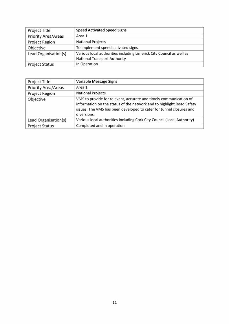
Project Title Speed Activated Speed Signs
Priority Area/Areas Area 1
Project Region National Projects
Objective To implement speed activated signs
Lead Organisation(s) Various local authorities including Limerick City Council as well as National Transport Authority
Project Status In Operation
Project Title Variable Message Signs
Priority Area/Areas Area 1
Project Region National Projects
Objective VMS to provide for relevant, accurate and timely communication of information on the status of the network and to highlight Road Safety issues. The VMS has been developed to cater for tunnel closures and diversions.
Lead Organisation(s) Various local authorities including Cork City Council (Local Authority)
Project Status Completed and in operation

12
Annex 2: Standards
The following table contains a list of standards relevant to the deployment of ITS and the projects
they are associated with
Project Standards
National Intermodal Journey Planner
The UK Standards: NPTG, NaPTAN & TransXchange with purpose of allowing the NIJP interoperate with the existing Journey Planner in Northern Ireland. The system will import ATCO.CIF, VDV 452 453 454, NaPTAN, NPTG and SIRI. The system has been specified to export GTFS, TransXchange and ATCO.CIF
Real Time Passenger Information SIRI – direct delivery data feed for real time prediction data based on bus stops subscribed for. (CEN/TS 15531) VDV 452 / VDV 453/ VDV 455 scheduled bus times and real time prediction data for based on performance on routes and trips
Smartcard Integrated Ticketing Project
ISO-14443 (Contactless Smartcards), and EU standard, "IOPTA" (Inter-Operable Public Transport Applications - Framework) Reference: IS EN 15320
M1 INSTANT Cross-Border Project
EN12966 VMS optical performance NTCIP v2 VMS control protocol DATEX II Traffic Data Exchange protocol
Deployment of a National Real Time Journey Time System using ANPR
UTMC ANPR standard
Traffic Counting/Classification System
(Pietzsch Automatisierungstechnik) PAT AVC100 Model Inductive Loop based Counter/Classifier collecting data to EURO 13 Classification level. OEM software called “Trafnet”
M50 Upgrade & GDA ITS Deployment Programme
EN12966 VMS optical performance NTCIP v2 VMS control protocol
PGMS (Parking Guidance Management System)
NTCIP V1 and V2 standards.
SCATS – Sydney Coordinated Adaptive Traffic System
ITS Port. Reference “SCATS6-SP-017-H SCATS Intelligent Transport Systems Interface”. Traffic Controller Specification Standard. Reference to latest standard is “Specification. TSC/4” RTA type approval for Traffic Controllers.
Congestion Monitoring/ Bus Priority System
UTMC standard for traffic & transport management. UK 2500 complaint standard
Kildare Traffic counting and congestion
UK 2500 complaint standard add on facility for traffic counting
Galway City UTMC/UTC and VMS UTMC standards
Traffic Management Centre UTMC standards
Luas light rail signalling system interface with urban traffic control systems
Communications systems: European and BS standards generally applied
Remote Monitoring System UK 2500 complaint standard for traffic signal control and monitoring
Microprocessor Optimised Vehicle Actuation
TD 35/06 - All-purpose trunk roads MOVA System of traffic control at traffic signals (The Highways Agency,UK, 2006).

13
Deployment of Emergency Roadside Telephone Service
Open Communication Protocol
eFlow: Barrier-Free Tolling (also known as free-flow or open road tolling) on the M50 Motorway.
Microwave DSRC Standards
Interoperable System for Electronic Tolling
IEA System
Traffic Control System for Motorways and Tunnels
NTCIP Standards UTMC Standards
Urban Traffic Control (UTC) SCOOT Standards
Variable Message Signs EN12966 VMS optical performance NTCIP v2 VMS control protocol
Roadworks Monitoring Local and national standards for service orientated architecture
Expansion of functionality and geographic coverage of existing urban traffic control system
SCOOT Standards

14
Annex 3: Glossary of Some Terms
ANPR-Automatic Number Plate Recognition
AUTC-Automated Urban Traffic Control
AVL-Automatic Vehicle Location
CCTV-Closed Circuit Television
GSM- Global System for Mobile Communications
MOVA-Microprocessor Optimised Vehicle Actuation
NIJP-National Interoperable Journey Planner
NRA-National Roads Authority
NTA-National Transport Authority
PGMS -Parking Guidance Management System
PGS -Parking Guidance Signs
RTPI-Real Time Passenger Information
SCATS- Sydney Coordinated Adaptive Traffic System
SCOOT- Split Cycle Offset Optimisation Technique
SMS-Short Message Service
UTMC-Urban Traffic Management and Control
UTC-Urban Traffic Control
VMS-Variable Message Signs