Embed Size (px)
Citation preview
1
Najas flexilis
the Slender Naiad
(species code 1833)
Article 17 Report Backing Document 2013
Photo by Cilian Roden
Áine O Connor
April 2013
2
Introduction to and structure of the report
This report contains an expanded version of the conservation status assessment for Najas flexilis that is published in NPWS (2013c). The structure of the report follows that of the 2013 Article 17 forms and uses the same numbering and headings. See http://www.npws.ie/publications/article-17-
reports-and-assessments for further information on the Irish Article 17 reports, where the 2013 overview report (NPWS, 2013a) and more detailed reports (NPWS, 2013b&c) can be downloaded. Since this report was written in April 2013, an NPWS study has produced further information on the distribution of Najas flexilis in Ireland (Roden and Murphy, 2014) and new records have been made during lake survey for ecological assessment purposes (e.g. Roden, 2014). In addition, site-specific conservation objectives have been published for Najas flexilis in several Special Areas of Conservation (see http://www.npws.ie/protected-sites/conservation-management-planning/conservation-
objectives). This report is being made available to coincide with the publication of a supporting document on Annex I lake habitats in Ireland (O Connor, 2015). Áine O Connor, June 2015
References
Evans, D. and Arvela, M. (2011) Assessment and reporting under Article 17 of the Habitats Directive Explanatory Notes & Guidelines for the period 2007-2012. Final version. July 2011. European Topic Centre on Biological Diversity
NPWS (2013a) The Status of Protected EU Habitats and Species in Ireland. Overview Volume 1. Unpublished Report, National Parks and Wildlife Services. Department of Arts, Heritage and the Gaeltacht, Dublin, Ireland.
NPWS (2013b) The Status of EU Protected Habitats and Species in Ireland. Habitat Assessments Volume 2. Version 1.0. Unpublished Report, National Parks and Wildlife Services. Department of Arts, Heritage and the Gaeltacht, Dublin, Ireland.
NPWS (2013c) The Status of EU Protected Habitats and Species in Ireland. Species Assessments Volume 3, Version 1.0. Unpublished Report, National Parks & Wildlife Services. Department of Arts, Heritage and the Gaeltacht, Dublin, Ireland.
O Connor, Á. (2015) Habitats Directive Annex I lake habitats: a working interpretation for the purposes of site-specific conservation objectives and Article 17 reporting. National Parks and Wildlife Service, Department of Arts, Heritage and the Gaeltacht, Ireland.
Roden, C. (2014) A report on the aquatic macrophytes in 12 lakes along the Maam Cross to Ballynahinch Road. Unpublished Report to RPS Group, Galway.
Roden, C. and Murphy, P. (2014) Targeted survey of Najas flexilis. Unpublished Report to the National Parks and Wildlife Service, Department of Arts, Heritage and the Gaeltacht, Ireland.
Citation: O Connor, Á. (2013) Article 17 assessment form and audit trail for Najas flexilis, the Slender Naiad (species code 1833). Backing Document. April 2013. National Parks and Wildlife Service, Department of Arts, Heritage and the Gaeltacht, Ireland.
3
Article 17 assessment form and audit trail for Najas flexilis, the Slender Naiad (species code 1833)
BACKING DOCUMENT
Áine O Connor
Freshwater Ecologist
April 2013 Slender Naiad
0.1 country
Ireland
0.2.1 Species Code
1833
Introduction
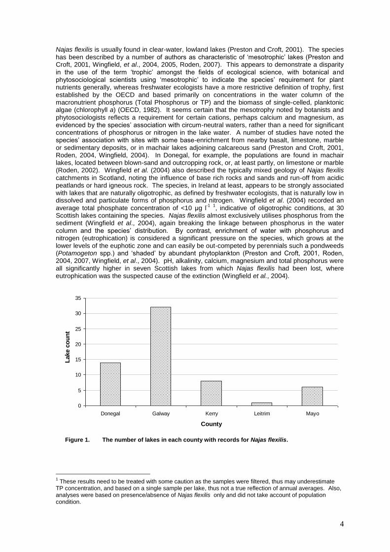
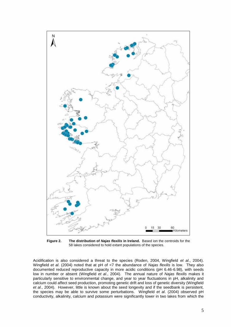
Najas flexilis is a small, annual, submerged macrophyte listed on Annex II and IV of the Habitats Directive. In Ireland, the species is protected under the Wildlife Acts (1976 and 2000), being listed on the Flora Protection Order (S.I. 94 of 1999). Najas flexilis has a somewhat disjunct distribution that has been variously described as amphi-Atlantic (Hultén and Fries, 1986), disjunctly circumpolar (Preston & Hill, 1997) and circumboreal (Preston and Croft, 2001). It is much more frequent in North America than in Eurasia (Godwin, 1975, Haynes, 1979, Preston and Croft, 2001). It has a northerly distribution in Europe, extending south to the Alps, but fossil evidence shows it was formerly much more widespread (Godwin, 1975, Preston and Croft, 2001, Wingfield et al. 2004). It is recognised as a rare and declining species in many countries (Preston and Croft, 2001). The core of the species’ European range is in Scotland and Ireland (Wingfield, et al., 2004, 2005, Roden, 2007). A fragile, relatively short (rarely > 30 cm) and permanently submerged species of the lower euphotic depths, the plant is often overlooked (Preston and Croft, 2001, Roden, 2004, Wingfield et al., 2004). Never the less, the NPWS has collated a database of some 340 plus records from shoreline, snorkel and boat surveys, building on detailed datasets produced by Dr Cilian Roden and others. The species was first recorded in Ireland by Daniel Oliver in Cregduff Lough, Co. Galway in 1850 (Botanical Gazette, No. 22, October, 1850) and is now believed to have occurred in 61 lakes in counties Donegal, Leitrim, Mayo, Galway and Kerry (See Figure 1). Connemara in west Galway appears to be the species’ Irish stronghold, having 31 of the recorded populations. Most of the known Najas flexilis lakes are located near the western fringe, with the exception of some of the larger occupied lakes such as Loughs Derg, Glenade, Corrib (Upper) and Leane (See Figure 2). Najas flexilis is typically found on flat to gently sloping areas of the lake bed with soft substrata of mud, silt or fine sand (Preston and Croft, 2001, Roden, 2002, 2004). An association with relatively organic, flocculent sediment is noted in the UK (Wingfield et al., 2004). It can occur at all depths between 0.5 m and 10 m, but is frequently associated with the lower depths of macrophyte growth, with scattered plants gradually giving way to bare mud or silt (Preston and Croft, 2001, Roden, 2002). The well-documented patchy distribution of the species within lakes is considered to be primarily determined by wave action, sediment type and competition; the first two being closely interlinked (Roden, 2004, 2007, Wingfield et al., 2004). Unsurprisingly for an annual species, Najas flexilis is an early coloniser and relatively poor competitor and, therefore, may be associated with naturally disturbed conditions (Wingfield et al., 2004).
4
Najas flexilis is usually found in clear-water, lowland lakes (Preston and Croft, 2001). The species has been described by a number of authors as characteristic of ‘mesotrophic’ lakes (Preston and Croft, 2001, Wingfield, et al., 2004, 2005, Roden, 2007). This appears to demonstrate a disparity in the use of the term ‘trophic’ amongst the fields of ecological science, with botanical and phytosociological scientists using ‘mesotrophic’ to indicate the species’ requirement for plant nutrients generally, whereas freshwater ecologists have a more restrictive definition of trophy, first established by the OECD and based primarily on concentrations in the water column of the macronutrient phosphorus (Total Phosphorus or TP) and the biomass of single-celled, planktonic algae (chlorophyll a) (OECD, 1982). It seems certain that the mesotrophy noted by botanists and phytosociologists reflects a requirement for certain cations, perhaps calcium and magnesium, as evidenced by the species’ association with circum-neutral waters, rather than a need for significant concentrations of phosphorus or nitrogen in the lake water. A number of studies have noted the species’ association with sites with some base-enrichment from nearby basalt, limestone, marble or sedimentary deposits, or in machair lakes adjoining calcareous sand (Preston and Croft, 2001, Roden, 2004, Wingfield, 2004). In Donegal, for example, the populations are found in machair lakes, located between blown-sand and outcropping rock, or, at least partly, on limestone or marble (Roden, 2002). Wingfield et al. (2004) also described the typically mixed geology of Najas flexilis catchments in Scotland, noting the influence of base rich rocks and sands and run-off from acidic peatlands or hard igneous rock. The species, in Ireland at least, appears to be strongly associated with lakes that are naturally oligotrophic, as defined by freshwater ecologists, that is naturally low in dissolved and particulate forms of phosphorus and nitrogen. Wingfield et al. (2004) recorded an average total phosphate concentration of <10 μg l
-1
1, indicative of oligotrophic conditions, at 30
Scottish lakes containing the species. Najas flexilis almost exclusively utilises phosphorus from the sediment (Wingfield et al., 2004), again breaking the linkage between phosphorus in the water column and the species’ distribution. By contrast, enrichment of water with phosphorus and nitrogen (eutrophication) is considered a significant pressure on the species, which grows at the lower levels of the euphotic zone and can easily be out-competed by perennials such a pondweeds (Potamogeton spp.) and ‘shaded’ by abundant phytoplankton (Preston and Croft, 2001, Roden, 2004, 2007, Wingfield, et al., 2004). pH, alkalinity, calcium, magnesium and total phosphorus were all significantly higher in seven Scottish lakes from which Najas flexilis had been lost, where eutrophication was the suspected cause of the extinction (Wingfield et al., 2004).
0
5
10
15
20
25
30
35
Donegal Galway Kerry Leitrim Mayo
County
Lake c
ou
nt
Figure 1. The number of lakes in each county with records for Najas flexilis.
1 These results need to be treated with some caution as the samples were filtered, thus may underestimate
TP concentration, and based on a single sample per lake, thus not a true reflection of annual averages. Also, analyses were based on presence/absence of Najas flexilis only and did not take account of population condition.
5
Figure 2. The distribution of Najas flexilis in Ireland. Based ion the centroids for the
58 lakes considered to hold extant populations of the species.
Acidification is also considered a threat to the species (Roden, 2004, Wingfield et al., 2004). Wingfield et al. (2004) noted that at pH of <7 the abundance of Najas flexilis is low. They also documented reduced reproductive capacity in more acidic conditions (pH 6.46-6.98), with seeds low in number or absent (Wingfield et al., 2004). The annual nature of Najas flexilis makes it particularly sensitive to environmental change, and year to year fluctuations in pH, alkalinity and calcium could affect seed production, promoting genetic drift and loss of genetic diversity (Wingfield et al., 2004). However, little is known about the seed longevity and if the seedbank is persistent, the species may be able to survive some perturbations. Wingfield et al. (2004) observed pH conductivity, alkalinity, calcium and potassium were significantly lower in two lakes from which the
6
species appeared to have been lost owing to acidification, while sediment iron was significantly higher (Wingfield et al., 2004). Wingfield et al. (2004) considered that Najas flexilis has rather specific environmental requirements and occupies a relatively narrow realised niche in Britain and Ireland. The pH of the water ranged from 6.62 - 8.3 (median of 7.46) and conductivity ranged from 55 - 447 μS cm
-1 (median of 235 μS
cm-1
) at 42 lakes studied (Wingfield et al., 2004). Alkalinity ranged from 6.71 - 69.71 mg l-1
(median of 23.45 mg l
-1) at 29 lakes, and calcium concentration in the water had a range of 2.06 - 33.4 mg l
-
1 (median of 9.59 mg l
-1) at 30 lakes (Wingfield et al., 2004). Alkalinity data are available for 18
Najas flexilis lakes from the Irish EPA 2007-2009 water quality report (Tierney et al., 2010) demonstrating a wider range of 2.5 – 106 mg l
-1, with a median of 13.2 mg l
-1 and average of 25 mg
l-1
. Summary data are provided in Table 1 for five Donegal lakes (Loughs Akibbon, Anure, Derg, Port and Shannagh), having overall averages of pH 7.12, conductivity 133.6 μS cm
-1 and total
alkalinity 24.4 mg l-1
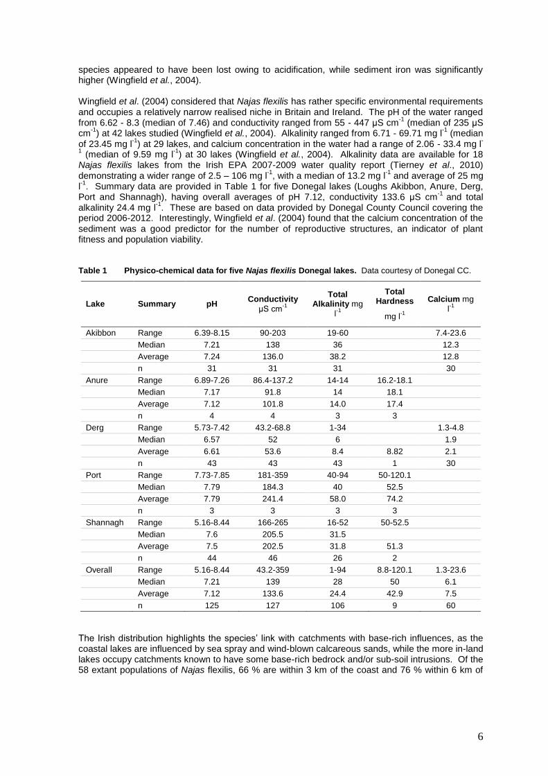
. These are based on data provided by Donegal County Council covering the period 2006-2012. Interestingly, Wingfield et al. (2004) found that the calcium concentration of the sediment was a good predictor for the number of reproductive structures, an indicator of plant fitness and population viability. Table 1 Physico-chemical data for five Najas flexilis Donegal lakes. Data courtesy of Donegal CC.
Lake Summary pH Conductivity
μS cm-1
Total Alkalinity mg
l-1
Total Hardness
mg l-1
Calcium mg
l-1
Akibbon Range 6.39-8.15 90-203 19-60 7.4-23.6
Median 7.21 138 36 12.3
Average 7.24 136.0 38.2 12.8
n 31 31 31 30
Anure Range 6.89-7.26 86.4-137.2 14-14 16.2-18.1
Median 7.17 91.8 14 18.1
Average 7.12 101.8 14.0 17.4
n 4 4 3 3
Derg Range 5.73-7.42 43.2-68.8 1-34 1.3-4.8
Median 6.57 52 6 1.9
Average 6.61 53.6 8.4 8.82 2.1
n 43 43 43 1 30
Port Range 7.73-7.85 181-359 40-94 50-120.1
Median 7.79 184.3 40 52.5
Average 7.79 241.4 58.0 74.2
n 3 3 3 3
Shannagh Range 5.16-8.44 166-265 16-52 50-52.5
Median 7.6 205.5 31.5
Average 7.5 202.5 31.8 51.3
n 44 46 26 2
Overall Range 5.16-8.44 43.2-359 1-94 8.8-120.1 1.3-23.6
Median 7.21 139 28 50 6.1
Average 7.12 133.6 24.4 42.9 7.5
n 125 127 106 9 60
The Irish distribution highlights the species’ link with catchments with base-rich influences, as the coastal lakes are influenced by sea spray and wind-blown calcareous sands, while the more in-land lakes occupy catchments known to have some base-rich bedrock and/or sub-soil intrusions. Of the 58 extant populations of Najas flexilis, 66 % are within 3 km of the coast and 76 % within 6 km of
7
the coast2 (see Figure 2). A more detailed analysis of the proximity of these lakes to calcareous
sands would be desirable. The co-occurrence of Najas flexilis and Margaritifera margaritifera (the freshwater pearl mussel) in many of these in-land catchments suggests some overlap in the species’ water chemistry requirements (71% or 10 of the lakes that are more than 6km from the coast are in freshwater pearl mussel catchments). Catchment geology may influence the distribution of the species through substratum type, as well as through nutrient and mineral chemistry. Roden (2004) noted that the species does not appear to prosper in Old Red Sandstone catchments, possibly owing to the coarser, sands that form the lake substratum in these areas. Najas flexilis is not found in marl or other hard water lakes (Habitats Directive, Annex I habitat code 3240) (Roden, 2007). Neither does Najas flexilis occur in dystrophic, peaty lakes (Roden, 2002). In Ireland, Najas flexilis appears to be associated with the Habitats Directive Annex I habitat 3130 (Oligotrophic to mesotrophic standing waters with vegetation of the Littorelletea uniflorae and/or Isoeto-Nanojuncetea). Wingfield et al. (2004) classified Najas flexilis lakes in their study using the standing water types of Palmer (1989) and found associations with Surface Water Types (SWT) 3, 4 and 5, identifying two Najas flexilis sub-groups of SWT 5. The Palmer (1989, 1992) classification system has since been revised by Duigan et al. (2006), who considered that Najas flexilis was most strongly associated with Group E lakes (“Northern, often large, low altitude and coastal, above-neutral lakes with high diversity of plant species, including Littorella uniflora, Myriophyllum alterniflorum, Potamogeton perfoliatus and Chara spp.”). It was also found in Group C2 and Group D lakes (Duigan et al., 2006). Roden (2004) noted the frequent co-occurrence of Potamogeton perfoliatus and Isoetes lacustris in Najas flexilis lakes, which is indicative of the mixed geological conditions favoured by the latter species (the pondweed being common in hard water lakes, the Quillwort characteristic of soft-water, oligotrophic lakes). Roden (2004) described two distinct groups of associated species in Irish Najas flexilis lakes; the first group included Callitriche hermaphroditica, several Chara species and broad-leaved pondweeds (Potamogeton spp.). A similar list of associated species was noted by Preston and Croft (2001). Wingfield et al. (2004) used macrophyte data at both lake and microhabitat level to characterise Najas flexilis habitat. The lake level data identified four groups, three of which (Groups 2, 3 and 4) bear some resemblance to Roden’s group 1. The second group of associated species identified by Dr Cilian Roden included Elatine hexandra and Nitella translucens (Roden, 2004). Wingfield et al. (2004) Group 1 lakes appear to have similar associated species. In some Irish lakes, both groups of associated species occurred and these accounted for the most species-rich Najas flexilis lakes, having a number of species that are rare or scarce along the west coast of Ireland (e.g. Ballynakill Lough, which is also home to Hydrilla verticillata) (Roden, 2004). Hydrilla verticillata is known only from two Irish lakes, both of which also contain Najas flexilis (Roden, 2007). The knowledge of the species’ distribution has improved since the last report in 2007 owing to the collation of historical records and new records made by the Irish EPA. No dedicated Habitats Directive monitoring was conducted during the reporting period, however, on the size of the known populations or the condition of their habitats.
0.2.3 Alternative Species name
0.2.4 Common Species name
Slender Naiad.
1.1.1 Distribution Map
This is the LAEA map that has been transformed from the map referred to in 1.1.4
2 Figures are based on GIS selection of lakes (Najas_flexilis_LakeSegment.shp) within 6km and 3km of coast (Ireland
outline shapefile: U:\Art17_2013\GISWorking\Background_Mapping_&_Grids\Country\Line\Ireland_Outline.shp. Shapefile created by Jochen Roller, origin of coastline data uncertain)
8
1.1.1a Sensitive Species
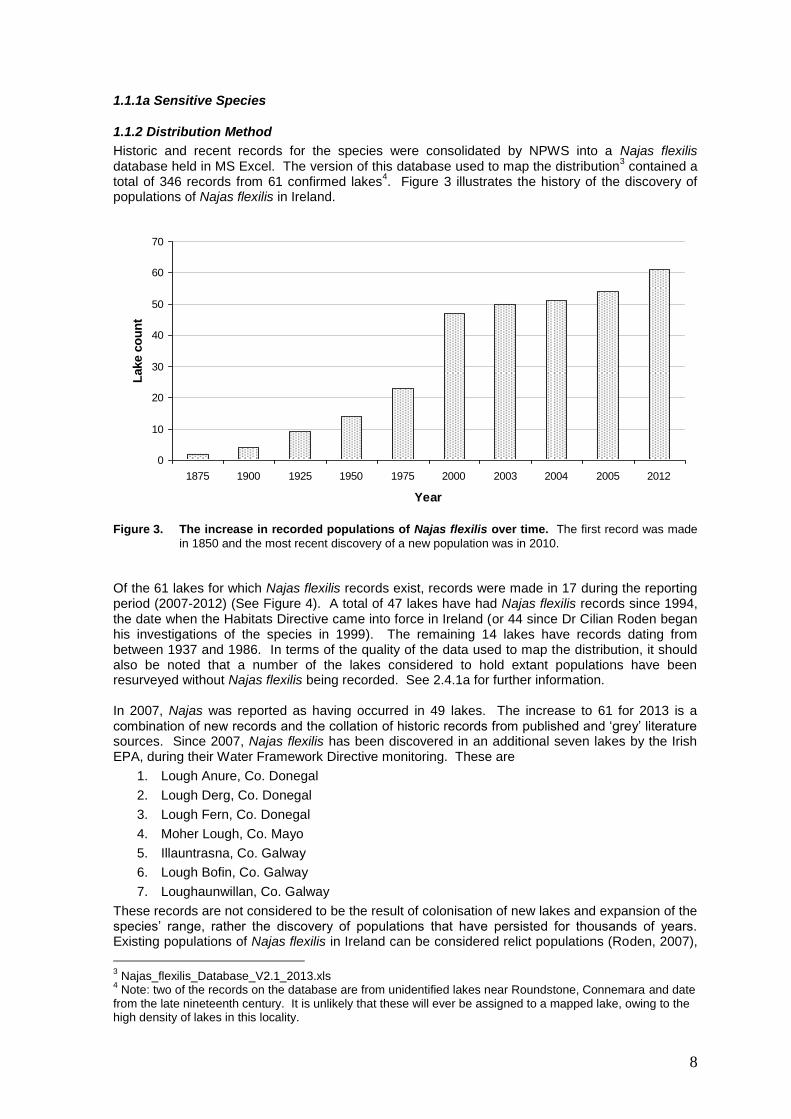
1.1.2 Distribution Method
Historic and recent records for the species were consolidated by NPWS into a Najas flexilis database held in MS Excel. The version of this database used to map the distribution
3 contained a
total of 346 records from 61 confirmed lakes4. Figure 3 illustrates the history of the discovery of
populations of Najas flexilis in Ireland.
0
10
20
30
40
50
60
70
1875 1900 1925 1950 1975 2000 2003 2004 2005 2012
Year
Lake c
ou
nt
Figure 3. The increase in recorded populations of Najas flexilis over time. The first record was made
in 1850 and the most recent discovery of a new population was in 2010.
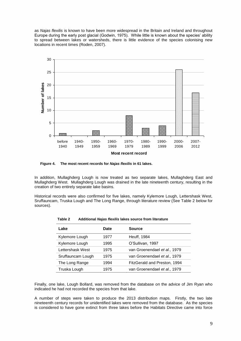
Of the 61 lakes for which Najas flexilis records exist, records were made in 17 during the reporting period (2007-2012) (See Figure 4). A total of 47 lakes have had Najas flexilis records since 1994, the date when the Habitats Directive came into force in Ireland (or 44 since Dr Cilian Roden began his investigations of the species in 1999). The remaining 14 lakes have records dating from between 1937 and 1986. In terms of the quality of the data used to map the distribution, it should also be noted that a number of the lakes considered to hold extant populations have been resurveyed without Najas flexilis being recorded. See 2.4.1a for further information. In 2007, Najas was reported as having occurred in 49 lakes. The increase to 61 for 2013 is a combination of new records and the collation of historic records from published and ‘grey’ literature sources. Since 2007, Najas flexilis has been discovered in an additional seven lakes by the Irish EPA, during their Water Framework Directive monitoring. These are
1. Lough Anure, Co. Donegal
2. Lough Derg, Co. Donegal
3. Lough Fern, Co. Donegal
4. Moher Lough, Co. Mayo
5. Illauntrasna, Co. Galway
6. Lough Bofin, Co. Galway
7. Loughaunwillan, Co. Galway
These records are not considered to be the result of colonisation of new lakes and expansion of the species’ range, rather the discovery of populations that have persisted for thousands of years. Existing populations of Najas flexilis in Ireland can be considered relict populations (Roden, 2007),
3 Najas_flexilis_Database_V2.1_2013.xls
4 Note: two of the records on the database are from unidentified lakes near Roundstone, Connemara and date
from the late nineteenth century. It is unlikely that these will ever be assigned to a mapped lake, owing to the high density of lakes in this locality.
9
as Najas flexilis is known to have been more widespread in the Britain and Ireland and throughout Europe during the early post glacial (Godwin, 1975). While little is known about the species’ ability to spread between lakes or watersheds, there is little evidence of the species colonising new locations in recent times (Roden, 2007).
0
5
10
15
20
25
30
before
1940
1940-
1949
1950-
1959
1960-
1969
1970-
1979
1980-
1989
1990-
1999
2000-
2006
2007-
2012
Most recent record
Nu
mb
er
of
lakes
Figure 4. The most recent records for Najas flexilis in 61 lakes.
In addition, Mullaghderg Lough is now treated as two separate lakes, Mullaghderg East and Mullaghderg West. Mullaghderg Lough was drained in the late nineteenth century, resulting in the creation of two entirely separate lake basins. Historical records were also confirmed for five lakes, namely Kylemore Lough, Lettershask West, Sruffauncam, Truska Lough and The Long Range, through literature review (See Table 2 below for sources).
Table 2 Additional Najas flexilis lakes source from literature
Lake Date Source
Kylemore Lough 1977 Heuff, 1984
Kylemore Lough 1995 O’Sullivan, 1997
Lettershask West 1975 van Groenendael et al., 1979
Sruffauncam Lough 1975 van Groenendael et al., 1979
The Long Range 1994 FitzGerald and Preston, 1994
Truska Lough 1975 van Groenendael et al., 1979
Finally, one lake, Lough Bollard, was removed from the database on the advice of Jim Ryan who indicated he had not recorded the species from that lake. A number of steps were taken to produce the 2013 distribution maps. Firstly, the two late nineteenth century records for unidentified lakes were removed from the database. As the species is considered to have gone extinct from three lakes before the Habitats Directive came into force
10
(Loughs Nafeakle, Ibby and Namanawaun) (Roden, 2007) and there is no evidence to suggest that the species has re-colonised any of the three, records for these three lakes were removed from the database used for mapping. A point shapefile was created, incorporating all records for currently occupied lakes (Najas_fleixilis_version_2.1_Feb_2013.shp). This shapefile was used in the preparation of the distribution and range maps and contained a total of 337 records from 58 confirmed lakes. A lake segment shapefile was created of all lakes currently with Najas flexilis populations (Najas_flexilis_LakeSegment.shp) by selecting lake polygons from the WFD_LakeSegment feature of the WFDGeodatabase. The initial selection was made by selecting all lake segments within 50 m of the point records. This selection was subsequently checked and Lough Derg, Donegal added. The 10 km distribution was first generated by selecting all hectads containing one or more Najas flexilis records. This resulted in a distribution of 41 ten-km squares or 4,100 km
2
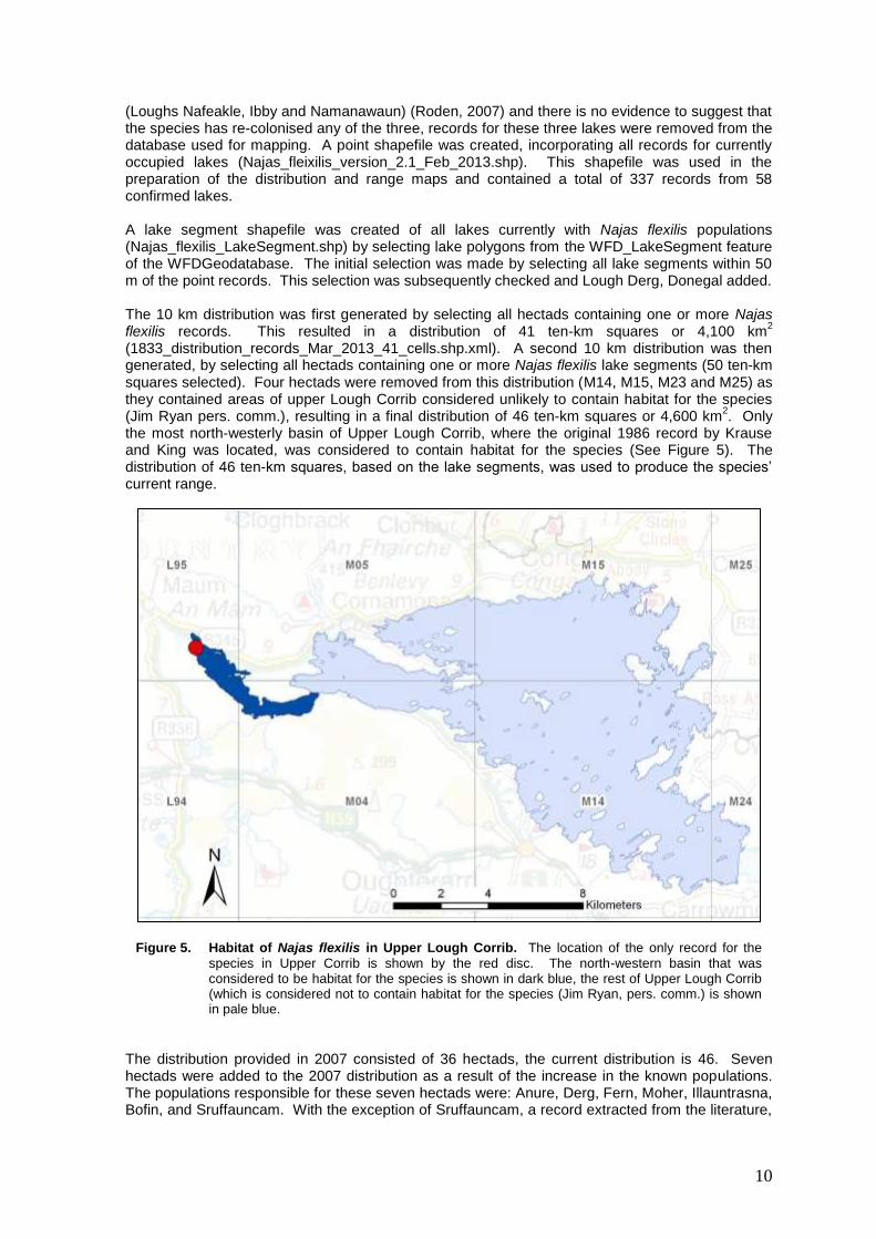
(1833_distribution_records_Mar_2013_41_cells.shp.xml). A second 10 km distribution was then generated, by selecting all hectads containing one or more Najas flexilis lake segments (50 ten-km squares selected). Four hectads were removed from this distribution (M14, M15, M23 and M25) as they contained areas of upper Lough Corrib considered unlikely to contain habitat for the species (Jim Ryan pers. comm.), resulting in a final distribution of 46 ten-km squares or 4,600 km
2. Only
the most north-westerly basin of Upper Lough Corrib, where the original 1986 record by Krause and King was located, was considered to contain habitat for the species (See Figure 5). The distribution of 46 ten-km squares, based on the lake segments, was used to produce the species’ current range.
Figure 5. Habitat of Najas flexilis in Upper Lough Corrib. The location of the only record for the
species in Upper Corrib is shown by the red disc. The north-western basin that was considered to be habitat for the species is shown in dark blue, the rest of Upper Lough Corrib (which is considered not to contain habitat for the species (Jim Ryan, pers. comm.) is shown in pale blue.
The distribution provided in 2007 consisted of 36 hectads, the current distribution is 46. Seven hectads were added to the 2007 distribution as a result of the increase in the known populations. The populations responsible for these seven hectads were: Anure, Derg, Fern, Moher, Illauntrasna, Bofin, and Sruffauncam. With the exception of Sruffauncam, a record extracted from the literature,
11
all of these populations were discovered since 2007 by the Irish EPA. A single 10 km square mapped in 2007 was dropped from the distribution. This was L63, the square that contains Lough Namanawaun, and should not have been included in 2007. This leaves an unexplained difference of three hectads, all of which were added because they contain areas of lake basins with Najas flexilis.
1.1.3 Year or Period
The IT tool does not allow dates before 1985, so the date provided in the reporting format of 1985-2012 is incorrect. The correct date is 1937-2012 The distribution is based on 58 populations considered to be extant. There were records for 17 of these during the reporting period (2007-2012). 47 had positive records since 1994. The remaining 11 populations have records dating from between 1937 and 1986.
1.1.4 Additional distribution map
The map is also provided on the Irish National Grid.
1.1.5 Range Map
The range map has been derived using the distribution map provided at 1.1.4 and the range tool. All unoccupied ten-km squares selected by the range tool contain at least one lake. Some hectads appear unlikely to contain potential Najas flexilis habitat as all lakes appear to be upland, base poor lakes (V77, V87 and V97) or the square is predominately coastal and marine with very limited available freshwater (B60).
2.1 Region
ATL - Atlantic
2.2 Published
Allott, N., Brennan, M., Cooke, D., Reynolds, J.D. and Simon, N. (1997) A Study of the Effects of stream Hydrology and Water Quality in Forested Catchments on Fish and Invertebrates: Volume 4, Stream Chemistry, Hydrology and Biota, Galway-Mayo Region. AQUAFOR Report. COFORD, Dublin.
Benthic Solutions Ltd. (2007) Monitoring of condition, density, location and total extent/population of Slender Naiad (Najas flexilis), in the Pertshire Lunan Lochs. Unpublished report, Scottish Natural Heritage, Perth.
Caffrey, J.M. and Rorslett, B. (1989) The macrophytic vegetation of Rusheenduff (Renvyle) Lough, Co. Galway. Irish Naturalists’ Journal 23 (4): 125-128.
Clabby, K.J., Bradley, C., Craig, M., Daly, D., Lucey, J., McGarrigle, M., O’Boyle, S., Tierney, D. and Bowman, J. (2008) Water Quality in Ireland 2004-2006. EPA, Wexford.
Duigan, C.A., Kovach, W.L. and Palmer, M (2006) Vegetation communities of British Lakes: a revised classification. Joint Nature Conservation Committee, Peterborough.
Dwyer, N. (2013) The Status of Ireland’s Climate, 2012. EPA, Wexford.
FitzGerald, R. and Preston, C.D.P. (1994) Preliminary survey of Najas flexilis. In: FitzGerald, R. Kerry - Vc H1 & H2. Report on preliminary survey of threatened & protected species. Unpublished Report to the National Parks and Wildlife Service, Dublin.
Free, G., Little, R., Tierney, D., Donnelly, K. and Coroni, R. (2006) A reference-based typology and ecological assessment system for Irish lakes. Preliminary Investigations. Final Report. Project 2000-FS-1-M1 Ecological Assessment of Lakes Pilot Study to Establish Monitoring Methodologies EU (WFD). EPA, Wexford.
Freshwater Ecology Group (FEG), TCD and Compass Informatics (2007) Conservation assessments of freshwater lake habitats in the Republic of Ireland. April 2007. In: National Parks and Wildlife Service (Ed.) The Status of EU Protected Habitats and Species in Ireland, Backing Documents, Article 17 Forms, Maps. Volume 2, 1110-1256.
Godwin, H. (1975) The history of the British flora. A factual basis for phytogeography. Cambridge University Press, Cambridge.
12
Heuff, H. (1984) The Vegetation of Irish Lakes. Parts 1 and 2. Unpublished Report to the Wildlife Service, Office of Public Works, Dublin.
Kelly-Quinn, M., Tierney, D., Coyle, S. and Bracken, J.J. (1997) A Study of the Effects of stream Hydrology and Water Quality in Forested Catchments on Fish and Invertebrates: Volume 3, Stream Chemistry, Hydrology and Biota, Wicklow Region. AQUAFOR Report. COFORD, Dublin.
Krause, W. and King, J.J. (1994) The ecological status of Lough Corrib, Ireland, as indicated by physiographic factors, water chemistry and macrophytic flora. Vegetatio 110: 149–161.
McGarrigle, M.L., Bowman, J.J., Clabby, K.J., Lucey, J., Cunningham, P., MacCarthaigh, M., Keegan, M., Cantrell, B., Lehane, M., Clenaghan, C. and Toner, P.F. (2002) Water Quality in Ireland 1998-2000. EPA, Wexford.
Ní Chatháin, B., Moorkens, E. and Irvine, K. (2013) Management Strategies for the Protection of High Status Water Bodies. 010-W-DS-3. Strive Report Series No. 99. EPA, Wexford.
NPWS (2013) Najas_flexilis_Database_V2_2013.xls MS Excel database of Najas flexilis records. The National Parks and Wildlife Service, Department of Arts, Heritage and the Gaeltacht, Dublin 2.
OECD (Organisation for Economic Co-operation and Development) (1982) Eutrophication of Waters. Monitoring Assessment and Control. OECD, Paris.
O Connor, Á. (2013) Article 17 assessment form and audit trail for Najas flexilis, the Slender Naiad (species code 1833) – Backing Document. Unpublished Report, National Parks and Wildlife Service, Dublin.
Oliver, D. (1851) Notes of a botanical ramble in Ireland last autumn. Phytologist 4: 125-128.
O’Sullivan, A. (1997) A summary report of the rare plants survey of plant species listed on Annex II of the EU Habitats Directive. Unpublished Report to the National Parks and Wildlife Service, Dublin.
Palmer, M. (1989) A botanical classification of standing waters in Great Britain; and a method for the use of macrophyte flora in assessing changes in water quality incorporating a reworking of data 1992. Joint Nature Conservation Committee, Peterborough. Research and Survey in Nature Conservation, No. 19.
Palmer, M. (1992) A botanical classification of standing waters in Great Britain; and a method for the use of macrophyte flora in assessing changes in water quality. Nature Conservancy Council, Peterborough.
Preston, C.D. and Hill, M.O. (1997) The geographical relationships of British and Irish vascular plants. Botanical Journal of the Linnean Society 124: 1–120.
Preston, C.D. and Croft, J.M. (2001) Aquatic Plants in Britain and Ireland. Harley Books, Colchester.
Roden, C.M. (1999) A survey of the sublittoral vegetation of 15 machair loughs in north west Ireland. Report to the National Heritage Council, Kilkenny.
Roden, C.M. (2002) Najas flexilis in Donegal. Unpublished Report to the National Parks and Wildlife Service, Dublin.
Roden , C.M. (2003) Najas flexilis in Connemara. Unpublished Report to the National Parks and Wildlife Service, Dublin.
Roden, C.M (2004) The distribution of Najas flexilis in Ireland 2002-2004. Unpublished Report to the National Parks and Wildlife Service, Dublin.
Roden, C.M. (2005) A new station for Hydrilla verticillata in Connemara. Irish Naturalists’ Journal 28 (3): 138-139.
Roden, C. (2007) Conservation Assessment of Slender Naiad (Najas flexilis (Willd.) Rostk. & W.L.E.Schmidt) in Ireland. March 2007. Slender Naiad (Najas flexilis) (1833) Conservation Status Assessment Report. Backing Document. In: National Parks and Wildlife Service (Ed.) The Status of EU Protected Habitats and Species in Ireland, Backing Documents, Article 17 Forms, Maps. Volume 2, 824-840.
Roden, C. (2012) A report on the sub-littoral environment around selected navigation markers in the north west sector of Lough Corrib. Unpublished report to RPS Group.
13
Tierney, D., Free, G., Kennedy, B., Little, R., Plant, C., Trodd, W. and Wynne, C. (2010) Water Quality of Lakes. In: M. McGarrigle, J. Lucey, and M. Ó Cinnéide (eds.) Water Quality in Ireland 2007-2009. EPA, Wexford.
van Groenendael, J.M., Hochstenbach, S.M.H., van Mansfeld, M.J.M. and Roozen, A.J.M. (1979) The influence of the sea and of parent material on wetlands and blanket bog in west Connemara, Ireland. Department of Geobotany, Catholic University, Nijmegen.
van Groenendael, J.M., van Mansfeld, M.J.M., Roozen, A.J.M. and Westhoff, V. (1993) Vegetation succession in lakes in the coastal fringe of West Connemara, Ireland. Aquatic Conservation: Marine and Freshwater Systems 3: 25-41.
Wingfield, R.A., Murphy, K.J., Hollingsworth, P. and Gaywood, M.J. (2004) The Ecology of Najas flexilis. Scottish Natural Heritage Commissioned Report No. 017 (ROAME No. F98PA02).
Wingfield, R.A., Murphy, K.J. and Gaywood, M.J. (2005) Lake habitat suitability for the rare European macrophyte Najas flexilis (Willd.) Rostk. & Schmidt. Aquatic Conserv: Mar. Freshw. Ecosyst. 15: 227–241.
2.3.1 Surface Area Range
6,800 km2
2.3.2 Method – range surface area
As for 1.1.2
2.3.3 Short-term trend Period (2.3.3 Range Trend period)
The recommended short-term trend period of 2001-2012 was chosen.
2.3.4 Short term trend direction
As there is no evidence of losses of populations during this trend period (See 1.1.2 and 2.4.1a), the short-term trend for range is considered to be stable. 14 populations have been discovered since 2001, however, this reflects an improvement in knowledge owing to the WFD macrophyte survey efforts of the Irish EPA, as well as dedicated Najas flexilis survey by Dr Cilian Roden. There is no evidence to suggest that this represents an expansion in the species’ range and all known Najas flexilis populations are still considered post-glacial relicts.
2.3.5 a) Short term trend magnitude min (2.3.5a Range Trend Magnitude Min)
Blank
2.3.5 b) Short term trend magnitude max (2.3.5b Range Trend Magnitude Max)
Blank
2.3.6 Long term trend period
The recommended long-term trend period of 24 years or 1989-2012 was used.
2.3.7 Long term trend direction
As there is no evidence of losses of populations during this trend period, the long-term trend for range is considered to be stable. The three populations considered to be extinct in Ireland (Loughs Ibby, Namanawaun and Nafeakle; see Section 2.4.1a for more information) occurred in close proximity to other Najas flexilis populations:
1. Ibby is less than 500 m from Mullaghderg East.
2. Nafeakle is c. 1.4 km from Derrywaking, with nine Najas flexilis populations known from the 10 km square in total.
3. Namanawaun is within 7 km of ten other Najas flexilis lakes.
14
Only one of these population extinctions (Namanawaun) affected the species’ range as mapped by hectad, as it is within a predominately marine and coastal 10 km square just south of the extant populations. The Namanawaun extinction appears to have occurred between 1975 and 1988 (van Groenendael et al., 1993), so before the recommended long-term trend period.
It is worth noting that the loss of one ten km square from a national distribution of 47 squares would represent a decline in distribution of 2%. However, given the close proximity of a large number of Najas flexilis lakes to Namanawaun (ten within 7 km, 31 in the wider Connemara region), the loss cannot be considered of national or regional significance in range terms. Arguably, Ibby was a more significant loss in terms of range as, with only Mullaghderg East and West and Lough Anure found within 20 km, its extinction made the species more vulnerable at local-level. These points illustrate some of the difficulties associated with:
o using hectads to map the range and
o the current methods for assessing the status of the range, which are based solely on the area of the range.
Added to that, changes in the range tool lead to changes in the area of the range for even a stable distribution, making it even more difficult to highlight genuine, significant losses in the national range.
2.3.8 a) Long term trend magnitude min
Blank
2.3.8 b) Long term trend magnitude min
Blank
2.3.9 a) – Favourable reference range
6,800 km2
Given the improved state of knowledge of the distribution of the species in 2013, the current range is considered to be the favourable reference range. It should be noted that the FRR may change in future reports. Two types of changes could occur:
1. The discovery of new populations, resulting in an expansion in the range. The likelihood of this is demonstrated by the discovery of seven populations by the Irish EPA between 2007 and 2010.
2. Population extinction, resulting in a contraction in the range. As detailed in 2.4.1a, there is uncertainty as to the status of 16 of the 58 populations listed as extant. Dedicated survey may confirm that some of these have been extinct since before the Directive came into force.
In addition, changes to the range mapping tool are likely to result in changes to the current and favourable reference ranges.
2.3.9 b) – Favourable reference range operator
2.3.9 c) – Favourable reference range unknown
2.3.9 d) – Favourable reference range method
The range derived from the current known distribution (see 1.1.2) using the Range Tool is considered to be the FRR, as there is no evidence of a decline since the Directive came into force. This is larger than the FRR set in 2007 owing to the discovery of additional populations, capture of historical population records omitted in 2007, the use of lake segments (polygons) to describe the range and the new range tool. The increase in the FRR is not the result of an expansion in the species distribution or colonisation of new sites. It is more likely that the actual range of the species is contracting in Ireland. The FRR is likely to change again in future reports, with the discovery of populations and confirmation of the extinction of others before 1994, as well as further changes to the range tool.
15
2.3.10 a) Reasons for change ( – genuine change)
The increase in range is not the result of colonisation of new sites and the expansion in the species range.
2.3.10 b) Reasons for change (– improved knowledge/more accurate data)
The improved knowledge and more accurate data on the distribution of Najas flexilis have resulted in seven hectads being added to the distribution in 2013. The populations responsible for this increase were: Anure, Derg, Fern, Moher, Illauntrasna, Bofin, and Sruffauncam. With the exception of Sruffauncam, a record extracted from the literature, all of these populations were discovered since 2007 by the Irish EPA. See 1.1.2 for further information.
In order to examine the range change that resulted from this improved knowledge, a range was calculated using the 2007 distribution data and current range tool. This generated a range of 5,500 km
2, which suggests improved knowledge increased the range by 1,300 km
2 or 26%.
2.3.10 c) Reasons for change (– use of different method)
Two methodological differences resulted in changes to the range between 2013 and 2007; the use of lake segments in mapping the distribution and the new range tool.
As explained in 1.1.2, the distribution was generated by selecting the hectads that contain the 58 lakes with extant populations of Najas flexilis. In 2007, a similar method was used, however, only one hectad (L95) was selected for Upper Lough Corrib. Two additional hectads (L94 and M05) were selected to cover the most north-westerly basin of Upper Lough Corrib in 2013
5. Two other
hectads have been added to cover the western edges of Lough Anaserd (L54) and Cloonee Middle Lough (V76). Consequently, four hectads were added to the distribution because they contain areas of lakes with Najas flexilis populations.
The 2013 range tool differs to the method of calculating the range used in 2007. As noted in 2.3.10 b), the range tool produced a range of 5,500 km
2 based on the 2007 distribution data. Those same
data in 2007 yielded a range of 4,800 km2, suggesting that the range tool produces significantly
grater ranges than the 2007 method (in this example, 14.6% larger).
2.4.1a Population size (individuals or agreed exception) – Unit
Number of mature individuals
Individual plants were considered to represent the mature individual. Population estimates were, in line with the EU Topic Centre Guidelines (Evans and Arvella, 2011) provided for 29 Najas flexilis populations by Roden (2004). Where these estimates were given as ‘>’ or ‘<’ an integer, that integer was used (e.g. >1,000 was called 1,000). The median and average population sizes, based on Roden’s 29 estimates, were calculated as 100 and 625, respectively. Both median and average population estimates were used to estimate the population size of the other 29 extant populations, giving national population estimates for the 58 extant populations of 21,032 and 36,257. This placed the national population in population class 7.
This population estimate was checked against Roden (2007), where 45 known populations were classed as:
1. Very large
2. Large
3. Small
4. 1-5 Plants
5. Unknown
These were assigned values as follows:
1. Very large 2,000
2. Large 1,000
3. Small 100
5The most north-westerly basin of Upper Lough Corrib overlaps four 10 km squares in total (L94, L95, M04
and M05). Only L95 was included in the 2007 distribution. M04 also contains Lough Bofin, a population first recorded by the EPA in 2004.
16
4. 1-5 Plants 3
5. Unknown 50
A similar method was used, summing the value for the 45 populations and estimating the size of the additional 13 populations reported in 2013, based on average (650) and median (1,000) population sizes. This method provided national estimates of 39,006 and 43,556, using average and median, respectively, again placing the national population in class 7.
As the majority of Dr Cilian Roden’s surveys covered a portion of the lakes in question and given that Roden (2004) did not provide population estimates for the 11 largest lakes, it is possible that these are underestimates. Consequently, it might be assumed that the population of Najas flexilis could in fact be up to twice as large and that a population size of class 8, 50,000-100,000 might be more appropriate.
Population size is a particularly challenging concept for a somewhat cryptic annual such as Najas flexilis. The use of a population size estimate is considered an inappropriate measure of the conservation status of the national Najas flexilis population. The reasons for this are considered below and also documented in detail in 2.4.3c.
Methods for surveying Najas flexilis
Under-recording of the species is not surprising, given that it lives fully submerged (no floating or emergent leaves or flowers) and is seldom found in drift specimens. While the presence of a population can be established from drift material (shoreline survey), it gives little indication of the size of that population. Furthermore, shoreline surveys are not a reliable method for establishing the absence of Najas flexilis from a lake. The plants do not float and, as a result, drift specimens are generally only found in more exposed lakes where wind and wave action is sufficient to bring plant material to shore (Wingfield et al., 2004). Wingfield et al. (2004) typically found drift specimens in August and September, owing to seasonal storm events and possibly also because older plants were more easily uprooted.
Boat surveys using a rake or grapnel are semi-quantitative at best. Wingfield et al. (2004) demonstrated that values of abundance attained by grapnelling consistently underestimated and did not correspond to the visual cover abundance estimates for the species. Its slender, delicate nature means that Najas flexilis is not readily caught on grapnels (Roden, 2007, Wingfield et al., 2004).
Snorkelling is the best method for estimating the cover abundance of the species (Roden, 2007, Wingfield et al., 2004), however, it too has its limitations in this regard, as it is seldom possible to cover the entire area of lake bottom.
Roden (2004 and 2007) and Wingfield et al. (2004) agreed that it is very difficult to estimate population size or propose any accurate, robust or repeatable abundance estimates for Najas flexilis or any deep water communities. Furthermore, the relationship between cover abundance estimates and the number of individual plants (mature individuals) is not well established.
The lifecycle of Najas flexilis and the timing of surveys
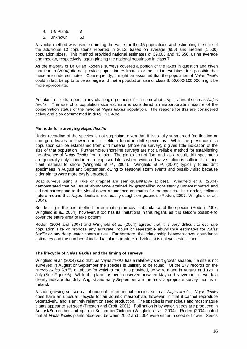
Wingfield et al. (2004) said that, as Najas flexilis has a relatively short growth season, if a site is not surveyed in August or September the species is unlikely to be found. Of the 277 records on the NPWS Najas flexilis database for which a month is provided, 98 were made in August and 129 in July (See Figure 6). While the plant has been observed between May and November, these data clearly indicate that July, August and early September are the most appropriate survey months in Ireland.
A short growing season is not unusual for an annual species, such as Najas flexilis. Najas flexilis does have an unusual lifecycle for an aquatic macrophyte, however, in that it cannot reproduce vegetatively, and is entirely reliant on seed production. The species is monecious and most mature plants appear to set seed (Preston and Croft, 2001). Pollination is by water, seeds are produced in August/September and ripen in September/October (Wingfield et al., 2004). Roden (2004) noted that all Najas flexilis plants observed between 2002 and 2004 were either in seed or flower. Seeds
17
either fall from the mature plants onto the lake bottom or are dispersed when the plants are uprooted in autumn (at which time, drift specimens can be found on the shore) (Preston and Croft, 2001). New seedlings have been observed to begin appearing in Scotland around June (Wingfield et al., 2004). It seems that seed germination requires some stratification, i.e. time spent at lower
temperatures, followed by warmer temperatures (>11 C), which ensures that seeds set in autumn do not germinate until the following summer (Wingfield et al., 2004).
0
20
40
60
80
100
120
140
May June July August September October November
Month
Nu
mb
er
of
reco
rds
Figure 6. The seasonal distribution of Najas flexilis records. Based on 277 records for
which the month was provided in Najas_flexilis_Database_V2.1_2013.xls
Density and distribution of Najas flexilis
The species is typically patchy in its distribution within a lake and Wingfield et al. (2004) observed that even a keen aquatic botanist in a boat or the water could overlook small, isolated patches of the species. The plant can occur between 0.5 m and 10 m depths at very variable densities; from scattered individuals to dense, mono-specific stands (Roden, 2004). It reaches its highest densities in deep, clear water (Roden, 2004). A study of a Pertshire lake (mainland Scotland), where 210 one by one metre relevés were sampled, found that the density of Najas flexilis varied from approximately 7.5 plants m
-2 to 0.2 m
-2, even though it was restricted to between 1.5 and 2.5
m depths (Benthic Solutions, 2007).
To complicate matters further, yearly fluctuations in seed production and germination are considered likely to result in large inter-annual variations in population size (Roden, 2007).
Wingfield et al. (2004) said that small changes in the environment can have a detrimental impact on Najas flexilis and it is possible that a certain amount of the inter-annual variation in population size is the result of natural fluctuations in the species’ environment. Annual variations in pH, alkalinity and calcium or other cation availability may be linked to weather patterns, particularly rainfall, storm events and wind. Higher rainfall and more storms may lead to more run-off and less buffering, and consequently lower pH, alkalinity and calcium. Inter-annual variation in wind is likely to affect these parameters in coastal lakes, where periodic delivery of wind-blown, calcareous sand is likely to be a key factor for the persistence of species. In this respect, inland lakes may be naturally better buffered than coastal lakes and, consequently, of central importance to the conservation of Najas flexilis in Ireland. Such natural fluctuations in the species’ environment can also clearly be altered as a result of anthropogenic activities (see 2.6).
18
All of these issues (survey methodologies, the short annual life-cycle, the spatial and temporal variations in density) demonstrate the difficulties associated with estimating the size of Najas flexilis populations in terms of number of mature individuals. Each problem introduces some uncertainty, meaning it is likely to be impossible to make statistically robust estimates of the number of mature individuals. Furthermore, even with statistically robust estimates, separation of the natural fluctuations in population size from those driven by anthropogenic pressures would be very challenging and require intensive, long-term research and monitoring. Therefore, assessment of the conservation status of the national Najas flexilis population based on the number of mature individuals is not reliable. Alternative approaches are suggested below.
Continuity in site occupancy
For the last Article 17 report, the population assessment was based on the number of continuing populations versus the number that had gone extinct during the trend period used (1977-2006) (Roden, 2007). Using this approach, current evidence indicates that 58 populations are extant and that none have gone extinct since the Habitats Directive came into force (1994), suggesting the national population may be in favourable condition.
Roden (2007), however, identified eight populations as being of uncertain status because dedicated survey between 1999 and 2005 had failed to find the species. Of these eight, Jim Ryan, to whom the original 1970s Lough Bollard record was attributed, has since identified it as an erroneous record. The remaining seven populations identified as uncertain by Roden (2007) were: Anillaunlughy (Galway), Clonee Middle (Kerry), Corrib Upper (Galway), Fin Lough (Mayo), Glenade (Leitrim), Muckross (Kerry), Upper Lough (Kerry). Ruth Wingfield also failed to relocate the species at Fin Lough in August 2000 (Wingfield et al., 2004). Corrib Upper, Glenade, Muckross and Upper lakes are on the EPA WFD lake monitoring programme and have been surveyed for macrophytes by the EPA lake biologists since 2007, however the species was not recorded.
The most recent records for Najas flexilis from Kylemore Lough are from 1995, despite a survey by Dr Cilian Roden of the northern side of the lake in 2003. In addition, the species was not re-found at the van Groenendael et al. (1979) sites during the 1988 resurvey (van Groenendael et al., 1993). It should be noted, however, that while van Groenendael et al. failed to find Najas flexilis at Lettershask East, it was recorded there by Dr Cilian Roden in 2005, emphasising the low reliability of shoreline survey, the likelihood of false negatives in any survey for the species and the difficulties associated with confirming a population extinction. Of the five sites where van Groenendael et al. (1979) recorded Najas flexilis, it hasn’t been seen in Lettershask West, Truska Lough or Lough Sruffauncam since it was first recorded in 1975.
In addition, the most recent records for the species from the Long Range, Adoolig and Nalawney Loughs are from 1994, 1985 and 1977, respectively. There has, however, been no survey of these lakes for Najas flexilis since these dates.
Roden (2004, 2007) found very small populations in both Keel and Tully Loughs. In 1999, Keel had only a few isolated, small and sparsely branched individuals growing at approximately 2 m depth (Roden, 2004). In 2004, only two individual plants were found in Tully (Roden, 2004). These data give rise to significant concern as to the continued existence of these populations.
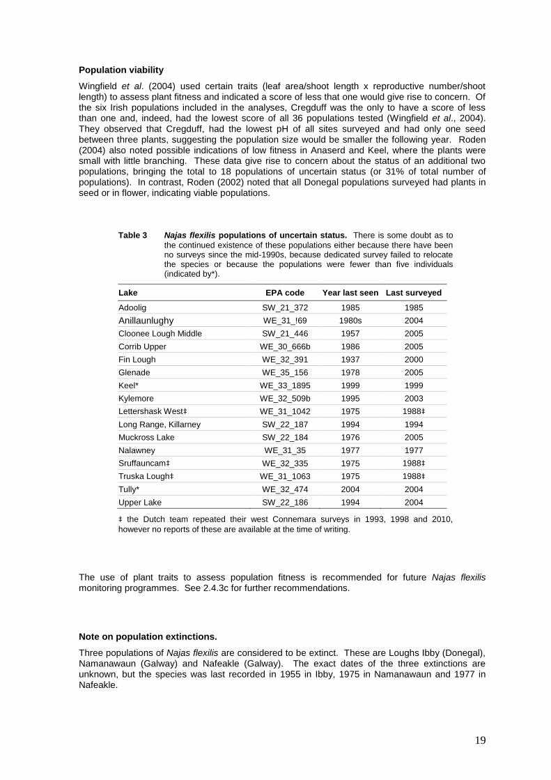
As a result, there is some uncertainty as to the continued existence of at least 16 (or 27.5%) of the 58 presumed extant populations (See Table 3).
In contrast to the uncertainty around these 16 populations, it should be noted that seven populations have been documented since 2007 (See 1.1.2) and that it is likely that further populations will yet be discovered. Under-recording of the species is not surprising, given the challenges outlined above. It is likely that yet more populations will be discovered with general lake macrophyte and dedicated Najas flexilis survey. It is also worthy of noted that Roden (2007) considered 34 of the then known populations to be in favourable condition.
On balance, however, the condition of the population, based on continuity of individual populations, is considered poor (unfavourable inadequate) owing to the lack of certainty around the status of 16 populations. This conclusion is line with the 2007 assessment of population conservation status.
19
Population viability
Wingfield et al. (2004) used certain traits (leaf area/shoot length x reproductive number/shoot length) to assess plant fitness and indicated a score of less that one would give rise to concern. Of the six Irish populations included in the analyses, Cregduff was the only to have a score of less than one and, indeed, had the lowest score of all 36 populations tested (Wingfield et al., 2004). They observed that Cregduff, had the lowest pH of all sites surveyed and had only one seed between three plants, suggesting the population size would be smaller the following year. Roden (2004) also noted possible indications of low fitness in Anaserd and Keel, where the plants were small with little branching. These data give rise to concern about the status of an additional two populations, bringing the total to 18 populations of uncertain status (or 31% of total number of populations). In contrast, Roden (2002) noted that all Donegal populations surveyed had plants in seed or in flower, indicating viable populations.
Table 3 Najas flexilis populations of uncertain status. There is some doubt as to
the continued existence of these populations either because there have been no surveys since the mid-1990s, because dedicated survey failed to relocate the species or because the populations were fewer than five individuals (indicated by*).
Lake EPA code Year last seen Last surveyed
Adoolig SW_21_372 1985 1985
Anillaunlughy WE_31_!69 1980s 2004
Cloonee Lough Middle SW_21_446 1957 2005
Corrib Upper WE_30_666b 1986 2005
Fin Lough WE_32_391 1937 2000
Glenade WE_35_156 1978 2005
Keel* WE_33_1895 1999 1999
Kylemore WE_32_509b 1995 2003
Lettershask West‡ WE_31_1042 1975 1988‡
Long Range, Killarney SW_22_187 1994 1994
Muckross Lake SW_22_184 1976 2005
Nalawney WE_31_35 1977 1977
Sruffauncam‡ WE_32_335 1975 1988‡
Truska Lough‡ WE_31_1063 1975 1988‡
Tully* WE_32_474 2004 2004
Upper Lake SW_22_186 1994 2004
‡ the Dutch team repeated their west Connemara surveys in 1993, 1998 and 2010,
however no reports of these are available at the time of writing.
The use of plant traits to assess population fitness is recommended for future Najas flexilis monitoring programmes. See 2.4.3c for further recommendations.
Note on population extinctions.
Three populations of Najas flexilis are considered to be extinct. These are Loughs Ibby (Donegal), Namanawaun (Galway) and Nafeakle (Galway). The exact dates of the three extinctions are unknown, but the species was last recorded in 1955 in Ibby, 1975 in Namanawaun and 1977 in Nafeakle.
20
Lough Ibby was surveyed for the species in 1995 and again in 2002, but it was not recorded on either occasion. Consequently, it can be assumed that Najas flexilis went extinct at Lough Ibby before the Habitats Directive came into force in 1994.
Similarly, Lough Namanwaun was surveyed in 1988 and again in 2003, but Najas flexilis was not recorded. The Dutch team who first recorded the species there in 1975 repeated their west Connemara surveys in 1993, 1998 and 2010 (as well as 1988), however it appears the species was never re-found. Again, it is assumed that the Namanawaun population was extinct before 1994.
The species was not found in Nafeakle when it was surveyed in 1995, 1999 and 2000. While the exact date of the extinction from the lake is unknown, the cause of the extinction is considered to be a fish farm that was evident in the 1995 orthophotograph. Again, it can be assumed that the Nafeakle population was extinct before 1994.
The cause of the extinctions at Ibby and Namawaun appear to be similar. Both lakes appear to be decreasing in area, becoming shallower and have increasing abundance of emergent macrophytes over time. Roden (2002) surveyed Lough Ibby twice in that year and noted that it was a small, shallow, dark lake, covered for the most part by dense Potamogeton natans and Phragmites australis. It had no fully submerged macrophytes (Roden, 2002). He also recorded a slight sulphur smell from the black bottom sediments and septic tanks as the only potential source of nutrients. Roden (2003) recorded dense stands of Phragmites australis surrounding Lough Namanawaun and a lake bottom of organic remains and dark mud. Significant changes appear to have occurred in Namanawaun between the two Dutch surveys, with the average number of species per relevé declining from 22.3 in 1975 to 14.4 in 1988 (van Groenendael et al., 1993).
A decrease in water depth and an increase in the abundance of emergent macrophytes may be, in part, a natural successional process linked to the gradual in-filling of these coastal lakes with wind-blown sand and organic material. The evident decrease in lake area may also be linked to this process of ‘terrestrialisation’. Comparison of the second edition 6“ maps with the 2005 orthophotographs illustrates a significant reduction in the area of both lakes, but some reduction in area is also evident between the 2000 and 2005 orthophotographs. The latter may reflect the seanson and flood levels when the photographs were taken. It may also suggest the impact of drainage activities. In addition, eutrophication may have accelerated the successional process in both lakes. Succession may also have been accelerated by coastal erosion, leading to increased volumes of wind-blown sand. It is thought unlikely that the appropriate environmental conditions for Najas flexilis will ever again be found in Loughs Ibby and Namawaun (Jim Ryan, pers. comm.).
Lough Nafeakle in the Roundstone blanket bog complex has become eutrophied as a result of a fish farm in the upstream Beaghcauneen Lough. The inflow from Beaghcauneen enters Lough Nafeakle near the latter’s outflow, and there is a second significant inflow to Lough Nafeakle from Cloonagat Lough to the east. It is considered possible that the species could re-establish in Nafeakle, if the fish farm were removed (Jim Ryan, pers. comm.). Natural re-colonisation of Lough Nafeakle could occur from the seed bank, although it should be cautioned that little is known about the persistence of Najas flexilis seeds. It is also possible that the species occurs elsewhere in the catchment and could re-colonise from upstream lakes.
2.4.1b Population size (other than individuals) – Min
Class 7 10,000-50,000
Minimum value provided 10,000
2.4.1c Population size (other than individuals) – Max
Class 7 10,000-50,000
Maximum value provided 50,000
2.4.2a Population size (other than individuals) – Unit
Blank
21
2.4.2b Population size (other than individuals) – Min
Blank
2.4.2c Population size (other than individuals) – Max
Blank
2.4.3a Additional information - Definition of "locality
Blank
2.4.3b Additional information - Conversion method
Blank
2.4.3c Additional information – Problems (encountered to provide population size estimation)
Roden (2004 and 2007) in providing some indications of population sizes (categorised as ‘very large’, ‘large’, ‘small, ‘1-5 plants’ or ‘extinct) for the lakes he had surveyed, acknowledged that these were subjective estimates and that it is very difficult to estimate population size or propose any robust or repeatable abundance estimate. Consequently, he did not use a national population estimate in the assessment of population conservation status in 2007. Wingfield et al. (2004) also said that accurately measuring plant abundance to assess the condition of the population in deep water communities is extremely difficult. Owing to the 2013 Article 17 requirements, however, Roden’s estimates, dating from 1999-2004, have had to be used here to derive the national population estimate.
The problems with estimating the number of mature individuals of Najas flexilis at lake and national scale include:
1. Najas flexilis is difficult to survey as it grows under water at depths of up to 10m. It is often commonest in the lower depths of the euphotic zones, where it is most difficult to survey and where it can reach its highest densities (Roden, 2002)
2. Counting the number of individuals can only be done by snorkelling or scuba diving
3. It is generally only possible to sub-sample a population using snorkelling or scuba diving
4. As the potential habitat in a lake is difficult to quantify, particularly in the absence of bathymetric data and substratum characterisation, multiplying from a sub-sample to a whole-lake population estimate is very difficult
5. Multiplying from a sub-sample to a whole-lake population estimate is made more difficult as the density of the plant is likely to vary within a lake
6, depending on factors from
substratum particle size and geochemistry, to light penetration, to wave exposure and competition from other macrophytes, epiphyton or phytoplankton
6. There is a limited season for the survey of this annual species. Seedlings have been noted to begin to germinate in Scotland in June (Wingfield et al., 2004) and the plant can survive until October, however August is generally cited as the time to survey (of the 277 records on the NPWS Najas flexilis database for which a month is provided, 98 were made in August and 129 in July, See Figure 6)
7. The plant is fragile and easily uprooted by storm events, so the density can vary within a single growing season
8. Added to that is the evidence that inter-annual fluctuations in population size occur naturally, as well as driven by anthropogenic pressures, and are linked to factors such as seed-germination (Roden, 2007)
9. It is apparent that there is significant variability in the natural carrying capacity/potential population size among lakes, as well as within lakes as noted in 5 above. Roden (2007) noted that the plant was least abundant in more base-poor lakes and most abundant in lakes that are transitional between hard and soft water
6 Roden (2002) noted that the plant can occur as scattered individuals and as dense stands.
22
Each point above introduces some uncertainty, meaning that it is likely to be impossible to make statistically robust estimates of the number of mature individuals for even one population of Najas flexilis, never mind the total national population from 58 different lakes. This means that using estimates of the number of mature individuals is not an appropriate method for assessing changes in the status of Najas flexilis populations. The author considers the estimates given to be effectively meaningless. Note also, that as an annual that does not germinate until summer, the number of mature individuals of the species in Ireland is zero at the time of writing.
A simple and effective means of assessing the national Najas flexilis population would be to monitor population continuity/extinction and report on the number of extant populations (one lake = one population). Roden (2007) noted that existing populations can be regarded as relicts, thus continuity in site occupancy is the best indicator of population health.
Another method for assessing national population status would be to assess population condition. Monitoring the condition of a population of Najas flexilis is likely to require a combination of survey methods, such as:
1. Spot-checks on the species distribution within the lake,
2. One or more detailed transects to establish the depth range, maximum depth and extent of the species,
3. Estimates of cover abundance at sampling stations,
4. Documentation of associated species at a sampling stations,
5. Measurement of traits to assess plant fitness, either in the field, e.g. presence of flowers/seeds on plants, or by removing specimens, e.g. leaf area, shoot length and number of reproductive structures (Wingfield et al., 2004, Benthic Solutions, 2007). Plant fitness is an indicator of the viability of the population,
The results of these investigations would be combined to determine the condition of the population and whether it is maintaining itself on a long-term basis as a viable component of the lake in question. A representative sample of populations would be surveyed across Ireland and the results combined to determine the national conservation status of the Najas flexilis population.
2.4.4 Year or period
1999-2005
Population estimates are based on the survey work of Dr Cilian Roden between 1999 and 2005. The number and distribution of populations is based on surveys from 1937-2012 (See 1.1.2 and 2.4.1a).
2.4.5 Method – population size
See 2.4.1a. 2 – Estimate based on partial data with some extrapolation of modelling.
2.4.6 Population - short trend period
2001-2012
Dedicated Najas flexilis surveys were undertaken by Dr Cilian Roden funded by the Heritage Council in 1999 and on behalf of the NPWS between 2002 and 2005. Irish EPA macrophyte surveys have yielded records for the species between 2002 and 2012. The data from these surveys were used to inform an expert opinion trend for the species for the period 2001-2012. The trend was based on the number of continuing populations, rather than population size (see 2.4.1a and 2.4.3c).
2.4.7 Short term trend direction
As no populations have been documented as going extinct during the trend period, the short-term trend direction is assumed to be stable. Given the lack of dedicated population monitoring during
23
the reporting period (2007-2012) and the unknown status of a number of populations (see 2.4.1a and 2.4.3c), however, the confidence in this assessment is low.
2.4.8a Short-term trend magnitude - Min
Blank
2.4.8b Short-term trend magnitude - Max
Blank
2.4.8c Short-term trend magnitude - confidence interval
Blank
2.4.9 Population Short-term trend method
The trend estimate is based on expert opinion and very limited data as explained in 2.4.1a, 2.4.3c, 2.4.6 and 2.4.7.
2.4.8 – 2.4.13 Long term trends
The recommended long-term trend period is 1989-2012. As no populations have gone extinct during this period, the long-term trend is considered to be stable. Three populations are considered to have gone extinct before the Habitats Directive came into force (see 2.4.1a). A loss of three populations from a total of 61 populations nationally, represents a decline of 5%.
2.4.14a Favourable reference population – Number
The current estimated minimum population size given at 2.4.1b is considered to be the favourable reference population (FRP). This is Class 7, 10,000-50,000 mature individuals.
No estimate of the number of individuals was given in 2007, rather the number of extant populations was provided. 46 populations were considered extant at that time, however ten of these had uncertain status. As explained in 1.1.2, knowledge of the distribution of Najas flexilis has improved since 2007 and the number of extant populations is now considered to be 58. The status of 16 of these 58 is considered to be uncertain (see 2.4.1a).
A target of 58 extant populations is considered to be a more appropriate FRP for Najas flexilis.
2.4.14b Favourable reference population – operators
Blank
2.4.14c Favourable reference population - unknown
Blank
2.4.14d Favourable reference population - method
The current estimated minimum population size (10,000) is considered to be the favourable reference population (FRP). This value is considered to represent the minimum value present when the Directive came into force and be adequate to ensure the long term survival of the species. However, the number of extant populations present when the Directive came into forces is a more appropriate value to assess Population status.
In 2007, population was assessed based on the number of extant populations. Population was assessed as Unfavourable Inadequate, as one population had become extinct during the trend period of 1977-2006, the status of ten populations was uncertain, two populations had fewer than ten plants and 34 populations were considered secure.
For this reporting period, provision of a population estimate for the number of mature individuals is required. This method is not considered an appropriate means of assessing the conservation status of the national Najas flexilis population (See 2.4.1a and 2.4.3c for further information).
24
As the status of 16 of the 58 populations considered currently extant is uncertain, the conservation status of the Najas flexilis population is considered to be poor or unfavourable inadequate.
2.4.15a Population reason for change genuine
It is assumed that there has been no change since the last monitoring period. See 2.4.1a for further information. As there has been no dedicated monitoring of Najas flexilis populations since the last reporting period, any genuine changes in population status have not been recorded.
2.4.15b Population reason for change improved/more accurate
As documented at 1.1.2, knowledge of the distribution and number of Najas flexilis populations has improved since 2007. While the estimates for individual lake populations and the average lake population size are derived from data from 1999-2005, the multiplier comes from the new figure of 58 presumed extant populations.
2.4.15c Population reason for change use of different method
No estimate of the number of individuals was given in 2007, rather the number of extant populations was provided. 46 populations were considered extant at that time, however ten of these had uncertain status and two had fewer than ten individuals. As explained in 1.1.2, knowledge of the distribution of Najas flexilis has improved since 2007 and the number of extant populations is now considered to be 58. The status of 16 of these 58 is considered to be uncertain (see 2.4.1a).
As explained in 2.4.1a and 2.4.3c, estimating the number of individual Najas flexilis plants is considered extremely unreliable and an inappropriate method for assessing the conservation status of the population.
2.5.1 Habitat surface Area
61.4 km2
Roden (2007) noted that, in favourable conditions, large areas of a lakebed can be colonised by a Najas flexilis monoculture. Although Najas flexilis can grow between 50 cm and ten metres below the water surface, it is generally found between 1 m and 5 m (Roden, 2002). Its vertical distribution is largely dependent on exposure to wave action at the shallow end and water clarity/light penetration at the deeper end (Roden, 2007, Wingfield et al., 2004).
In 2007, as bathymetric data were unavailable, the habitat area was based on the entire lake surface area, with the exception of Lough Corrib, where only the north-western basin was included (Roden, 2007). The habitat area was given as 4,960 ha and considered to be an overestimate.
For this Article 17 report, total lake surface area was again used. Firstly, the total lake surface area was summed for the 57 lakes other than Upper Lough Corrib as 5,639.6 ha or 56.3 km
2. For Upper
Lough Corrib, the area of the most north-westerly basin (See Figure 5) was added. This basin had a surface area of 497.5 ha or 4.97 km
2 and when added to the area for the other 57 lakes gave a
total habitat surface area of 6,137.1 ha or 61.4 km2. This is clearly a significant over-estimate of
the available habitat for mature plants of Najas flexilis, however, it could be claimed that the plant can use the entire lake volume during its lifecycle (pollen and seed dispersal).
The habitat area estimates could be refined based on:
1. Use of EPA bathymetric data (the areas of lake bed between 1 and 5 m depths and 0.5 and 10 m depths could be calculated, to give a minimum and maximum available habitat estimate for each lake),
2. Improved knowledge of the spatial and depth distribution of the species, and mapping of its extent in each lake,
3. Data on light penetration/ euphotic depth for each lake,
4. Information on substratum types in the lakes.
25
2.5.2 Year or period
The habitat area was based the “LakeSegment” feature data class from the EPA’s Water Framework Geodatabase (WFDGeodatabase.mdb Ver Oct 2011). The lake segment vectors are at 1:50,000 scale and based on the 2005 OSi Orthophotographs.
2.5.3 Habitat Method
See 2.5.1. 2 Estimate based on partial data with some extrapolation and/or modelling
2.5.4a Quality of habitat
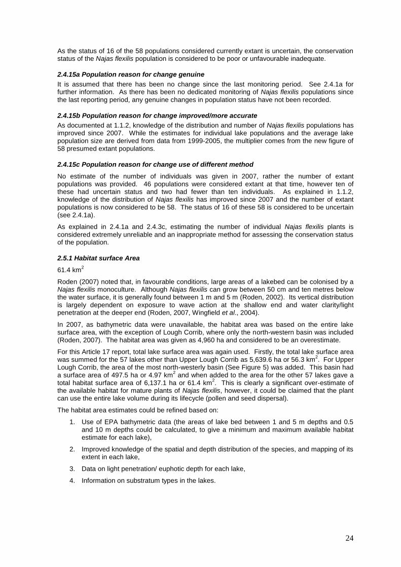
Eutrophication and acidification are considered to have a significant negative impact on Najas flexilis (Preston and Croft, 2001, Roden, 2004, 2007, Wingfield, et al., 2004). Consequently, data on the ecological status of the Najas flexilis lakes were used to asses the quality of the habitat for the species.
The Irish EPA is responsible for co-ordinating the Water Framework Directive monitoring programme, for monitoring the lake biological quality elements (other than fish, which are monitored by Inland Fisheries Ireland) and for reporting on ecological status. The lake monitoring programme follows a three-year-cycle. EPA lake ecological status for the years 2009-2011 inclusive was used to assess the quality of the habitat for Najas flexilis.
Ecological status data were available for 25 of the 58 lakes with extant populations for the period 2009-2011. A number of WFD quality elements were used to assess whether the lakes were impacted by eutrophication, namely:
1. Chlorophyll a status
2. Nutrient condition status
3. Macrophyte status
4. Phytobenthos status
5. Phytoplankton composition status
Nutrient enrichment (with phosphorus and/or nitrogen) can promote phytoplankton growth (as indicated by Chlorophyll a concentration) leading to shading of Najas flexilis and reduced light penetration. Nutrient enrichment can also favour epiphytic and epipelic algal communities (as indicated by phytobenthos status) or more competitive submerged macrophyte species (as indicated by macrophyte status) which can out-compete Najas flexilis. Chlorophyll a, macrophyte, phytobenthos and phytoplankton composition all demonstrate biological responses to nutrient enrichment. As Najas flexilis is considered likely to grow best in oligotrophic conditions, as defined by the standard OECD approach (see 0.2.1), the target for each of the five listed elements is high status
7. WFD ‘good’ status is considered equivalent to poor conservation condition, while
moderate, poor or bad status is considered equivalent to bad conservation condition. For the Najas flexilis habitat quality to be considered to be in favourable condition in terms of nutrients and eutrophication, all five elements must be at high status (see ’Habitat condition – nutrients and eutrophication in Tables 4 and 5). This use of the lowest common denominator of the five quality elements is in keeping with classification under the WFD, which is derived by taking the lowest status classes for a range of specified biological, physico-chemical and hydromorphological quality elements (Tierney, et al. 2010). Five of the 25 Najas flexilis lakes were in favourable habitat condition for nutrients and eutrophication during the 2009-2011 monitoring period, 15 were in poor condition and five in bad condition (Table 4).
WFD Acidification/Alkalisation status was used to assess whether the Najas flexilis habitat was impacted by acidification (See Table 4). Only one lake failed to reach good status owing to Acidification/Alkalisation status.
Final habitat condition was then based on the lowest status class from the nutrients and eutrophication condition and acidification condition (Table 4), resulting in final habitat condition for
7 WFD high status reflects oligotrophic conditions, WFD good status reflects mesotrophic conditions. The
high-good boundary may be too stringent for Najas flexilis, however the good-moderate boundary is not
stringent enough and the species is likely to be significantly impacted by eutrophication in some lakes classified as ‘good’ status. As a result the more stringent threshold was adopted.

26
the 25 Najas flexilis lakes for the 2009-2011 monitoring period of five in favourable condition, 14 in poor condition and in six bad condition.
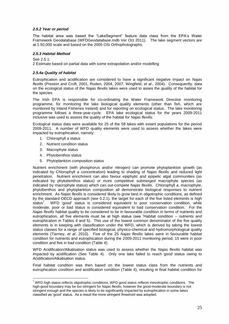
In addition, limited status data were available for four additional lakes for the period 2007-2009 (See Table 5).
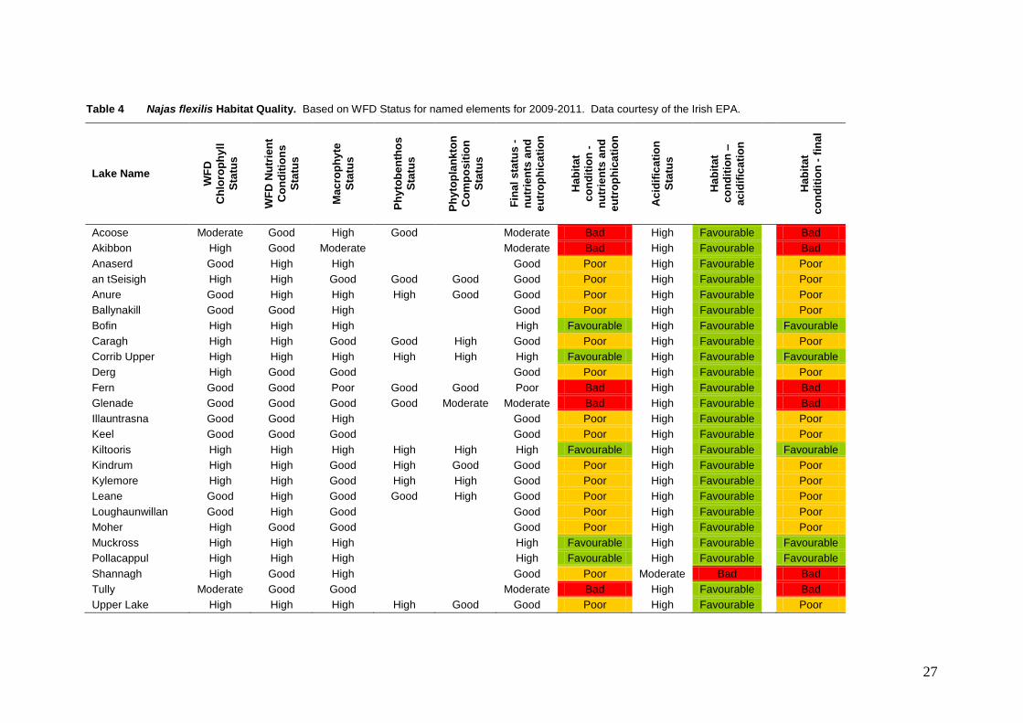
27
Table 4 Najas flexilis Habitat Quality. Based on WFD Status for named elements for 2009-2011. Data courtesy of the Irish EPA.
Lake Name
WF
D
Ch
loro
ph
yll
Sta
tus
WF
D N
utr
ien
t
Co
nd
itio
ns
Sta
tus
Ma
cro
ph
yte
Sta
tus
Ph
yto
be
nth
os
Sta
tus
Ph
yto
pla
nk
ton
Co
mp
os
itio
n
Sta
tus
Fin
al
sta
tus
-
nu
trie
nts
an
d
eu
tro
ph
ica
tio
n
Hab
ita
t
co
nd
itio
n -
nu
trie
nts
an
d
eu
tro
ph
ica
tio
n
Acid
ific
ati
on
Sta
tus
Hab
ita
t
co
nd
itio
n –
ac
idif
ica
tio
n
Hab
ita
t
co
nd
itio
n -
fin
al
Acoose Moderate Good High Good Moderate Bad High Favourable Bad
Akibbon High Good Moderate Moderate Bad High Favourable Bad
Anaserd Good High High Good Poor High Favourable Poor
an tSeisigh High High Good Good Good Good Poor High Favourable Poor
Anure Good High High High Good Good Poor High Favourable Poor
Ballynakill Good Good High Good Poor High Favourable Poor
Bofin High High High High Favourable High Favourable Favourable
Caragh High High Good Good High Good Poor High Favourable Poor
Corrib Upper High High High High High High Favourable High Favourable Favourable
Derg High Good Good Good Poor High Favourable Poor
Fern Good Good Poor Good Good Poor Bad High Favourable Bad
Glenade Good Good Good Good Moderate Moderate Bad High Favourable Bad
Illauntrasna Good Good High Good Poor High Favourable Poor
Keel Good Good Good Good Poor High Favourable Poor
Kiltooris High High High High High High Favourable High Favourable Favourable
Kindrum High High Good High Good Good Poor High Favourable Poor
Kylemore High High Good High High Good Poor High Favourable Poor
Leane Good High Good Good High Good Poor High Favourable Poor
Loughaunwillan Good High Good Good Poor High Favourable Poor
Moher High Good Good Good Poor High Favourable Poor
Muckross High High High High Favourable High Favourable Favourable
Pollacappul High High High High Favourable High Favourable Favourable
Shannagh High Good High Good Poor Moderate Bad Bad
Tully Moderate Good Good Moderate Bad High Favourable Bad
Upper Lake High High High High Good Good Poor High Favourable Poor
28
Table 5 Najas flexilis Habitat Quality. Based on WFD Status for named elements for 2007-2009. Data
courtesy of the Irish EPA.
Lake Name
WF
D
Ch
loro
ph
yll
Sta
tus
WF
D N
utr
ien
t
Co
nd
itio
ns
Sta
tus
Tro
ph
ic S
tatu
s
Ma
cro
ph
yte
Sta
tus
Fin
al
sta
tus
-
nu
trie
nts
an
d
eu
tro
ph
ica
tio
n
Ha
bit
at
co
nd
itio
n -
nu
trie
nts
an
d
eu
tro
ph
ica
tio
n
Cloonee Middle High High Favourable
Fin High Good Mesotrophic Good Good Poor
Maumeen High Moderate Eutrophic High Moderate Bad
Mullaghderg West Good Good Poor
Table 6 presents the summary data for the 29 lakes for which WFD status data were available for 2009-2011 or 2007-2009. As the sample size of 29 is 50% of the lakes considered to have extant populations of Najas flexilis, it is considered to be representative of the species’ habitat nationally.
The approach to determining the condition of the Najas flexilis habitat used here could be considered conservative, as no statistical relationships between WFD status (for the various biological and physico-chemical elements used) and population condition have been established. It is quite possible that such a relationship will not exist, as the ecological quality of lakes forms a continuum along trophic and other gradients (FECG and CI, 2007). It is likely that Najas flexilis is tolerant of mesotrophic conditions and may even reach high abundance where chlorophyll a and TP are slightly above oligotrophic levels. However, when one considers that summer chlorophyll a typically had a concentration of c. 4 μg l
-1 in Irish lakes considered to be in reference condition
(Free et al., 2006) and given that Najas flexilis was formally much more widespread in Ireland and Europe (Godwin, 1975), it is reasonable to assume that favourable and viable populations of the species existed in oligotrophic lakes before large-scale anthropogenic land-use change.
Table 6 Summary of Najas flexilis Habitat Quality. For the
29 lakes for which WFD Status data were available for 2009-2011. Data courtesy of the Irish EPA.
Habitat Condition Lake Count Percentage
Favourable 6 21%
Poor 16 55%
Bad 7 24%
Given that 55% of monitored lakes were in poor condition, 24% in bad condition (see Table 6) and taking into consideration that this classification may have been overly conservative for those lakes that are in the lower 25
th or 50
th percentile of the good status band (i.e. the more ‘oligotrophic’ of
mesotrophic lakes), the overall quality of the habitat was considered to be unfavourable inadequate or ‘moderate’.
Note on trophic status
Schedule Five of S.I. 272 of 2009 establishes the criteria for calculating lake status using chlorophyll a (phytoplankton biomass). Two sets of thresholds are given, linked to lake types. The thresholds established for the moderate and higher alkalinity types (7, 8, 11 and 12) are considered more appropriate for Najas flexilis lakes. The target for Najas flexilis lakes is currently considered to be high status or oligotrophic conditions and, therefore, the mean chlorophyll a concentration should be less than 5.8 μg l
-1 during the growing season (March-October). Where the chlorophyll a
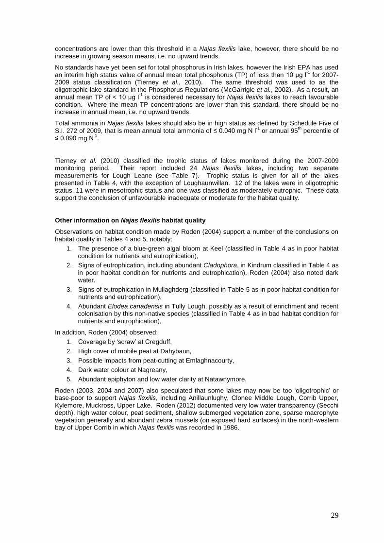
29
concentrations are lower than this threshold in a Najas flexilis lake, however, there should be no increase in growing season means, i.e. no upward trends.
No standards have yet been set for total phosphorus in Irish lakes, however the Irish EPA has used an interim high status value of annual mean total phosphorus (TP) of less than 10 μg l
-1 for 2007-
2009 status classification (Tierney et al., 2010). The same threshold was used to as the oligotrophic lake standard in the Phosphorus Regulations (McGarrigle et al., 2002). As a result, an annual mean TP of < 10 μg l
-1 is considered necessary for Najas flexilis lakes to reach favourable
condition. Where the mean TP concentrations are lower than this standard, there should be no increase in annual mean, i.e. no upward trends.
Total ammonia in Najas flexilis lakes should also be in high status as defined by Schedule Five of S.I. 272 of 2009, that is mean annual total ammonia of ≤ 0.040 mg N l
-1 or annual 95
th percentile of
≤ 0.090 mg N 1.
Tierney et al. (2010) classified the trophic status of lakes monitored during the 2007-2009 monitoring period. Their report included 24 Najas flexilis lakes, including two separate measurements for Lough Leane (see Table 7). Trophic status is given for all of the lakes presented in Table 4, with the exception of Loughaunwillan. 12 of the lakes were in oligotrophic status, 11 were in mesotrophic status and one was classified as moderately eutrophic. These data support the conclusion of unfavourable inadequate or moderate for the habitat quality.
Other information on Najas flexilis habitat quality
Observations on habitat condition made by Roden (2004) support a number of the conclusions on habitat quality in Tables 4 and 5, notably:
1. The presence of a blue-green algal bloom at Keel (classified in Table 4 as in poor habitat condition for nutrients and eutrophication),
2. Signs of eutrophication, including abundant Cladophora, in Kindrum classified in Table 4 as in poor habitat condition for nutrients and eutrophication), Roden (2004) also noted dark water.
3. Signs of eutrophication in Mullaghderg (classified in Table 5 as in poor habitat condition for nutrients and eutrophication),
4. Abundant Elodea canadensis in Tully Lough, possibly as a result of enrichment and recent colonisation by this non-native species (classified in Table 4 as in bad habitat condition for nutrients and eutrophication),
In addition, Roden (2004) observed:
1. Coverage by ‘scraw’ at Cregduff,
2. High cover of mobile peat at Dahybaun,
3. Possible impacts from peat-cutting at Emlaghnacourty,
4. Dark water colour at Nagreany,
5. Abundant epiphyton and low water clarity at Natawnymore.
Roden (2003, 2004 and 2007) also speculated that some lakes may now be too ‘oligotrophic’ or base-poor to support Najas flexilis, including Anillaunlughy, Clonee Middle Lough, Corrib Upper, Kylemore, Muckross, Upper Lake. Roden (2012) documented very low water transparency (Secchi depth), high water colour, peat sediment, shallow submerged vegetation zone, sparse macrophyte vegetation generally and abundant zebra mussels (on exposed hard surfaces) in the north-western bay of Upper Corrib in which Najas flexilis was recorded in 1986.
30
Table 7 Najas flexilis Lake trophic status 2007-2009. Based on modified OECD System (see Tierney et al., 2010). O is oligotrophic, M is mesotrophic, m-E is
moderately eutrophic, s-E is strongly eutrophic. All exceedences of the oligotrophic targets are highlighted in amber (poor) or red (bad), as appropriate. Data courtesy of the Irish EPA.
Lake Name Seg_cd County Trophic
Status 2007 * Trophic
Status 2008 * Trophic
Status 2009 *
TP 2007
mg/l
TP 2008
mg/l
TP 2009
mg/l
EPA assigned Trophic
status 2007-2009
Acoose SW_22_208 KY O s-E m-E 0.010 0.011 m-E
Akibbon NW_39_11 DL O O M O
Anaserd WE_31_211 GY O O O O
an tSeisigh NW_38_61 DL O O M 0.010 O
Anure NW_38_83 DL O O M 0.006 O
Ballynakill WE_32_479 GY M O M M
Bofin WE_30_335 GY M O O O
Caragh SW_22_207 KY O M O 0.012 0.010 0.007 O
Corrib Upper WE_30_666b GY M M O 0.012 0.008 0.006 M
Derg NW_01_115 DL O M O M
Fern NW_39_13 DL O M M 0.013 M
Glenade WE_35_156 LM M M M M
Illauntrasna WE_31_1126 GY M O O O
Keel WE_33_1895 MO M M M M
Kiltooris NW_38_47 DL O M O 0.009 M
Kindrum NW_38_670 DL O M O 0.008 O
Kylemore WE_32_509b GY O O O O
Leane SW_22_185 KY M M O 0.015 0.016 0.010 M
Leane Ross Bay SW_22_185 KY m-E M M 0.079 0.109 0.061 M
Moher WE_32_406 MO O O O O
Muckross SW_22_184 KY O O O 0.009 0.008 0.007 O
Pollacappul WE_32_509a GY O O O O
Shannagh NW_38_678 DL M M O M
Tully WE_32_474 GY M O m-E M
Upper SW_22_186 KY O M O 0.009 0.007 0.006 M
* based on annual max. chlorophyll a
31
2.5.4b Quality of habitat – method
See 2.4.5a.
2.5.5 Short term trend period
2001-2012
The habitat area was estimated using mapping data for lake surface areas, rather than baseline survey of the species’ habitat (see 2.5.1). In contrast to terrestrial species, direct mapping of the habitat of a submerged macrophyte is not practically possible and it will always be necessary to employ some form of habitat modelling to determine the area of Najas flexilis habitat.
There is no evidence of the destruction of any areas of the species’ habitat during the trend period. As a result, the short-term trend for the area of the species’ habitat is considered to be stable.
In general, Najas flexilis habitat is more likely to be damaged rather than destroyed/lost, although the changes in Loughs Ibby and Namanawaun before the Habitats Directive came into force could be considered to be habitat loss (see 2.4.1a). The trends in Najas flexilis habitat quality are difficult to determine, despite the availability of significant amounts of water quality and WFD monitoring data. Monitoring the trophic status of Irish lakes has been a focus of the Irish EPA lake monitoring programmes, however the classification of oligotrophic and mesotrophic (or now high and good) status lakes together as ‘satisfactory’ means that any deteriorations from oligotrophic to mesotrophic, or any improvements from mesotrophic to oligotrophic, are not apparent.
Tierney et al. (2010) illustrated the long-term trend in trophic status in Irish lakes, expressed in accordance with the areas of monitored lakes (their Figure 4.2 is here reproduced as Figure 7). The authors note that ‘the percentage of lake area in each trophic category has remained relatively stable since 1998, based on the modified OECD scheme’ indicating that the short-term trend in lake habitat quality generally is stable. It should be noted, however, that only 25 of the 58 Najas flexilis lakes are currently included in the EPA WFD monitoring programme (see Table 6 for list). It is not currently possible to determine how representative this general lake trend is of Najas flexilis lakes, or of trends within the combined oligotrophic and mesotrophic categories.
Before the WFD monitoring programme began, lake monitoring in Ireland concentrated on larger lakes, drinking water supplies and lake research for WFD purposes. Significant quantities of data were gathered for large numbers of lakes, but these are not available in a readily accessible format. The EPA and local authorities have examined and reported on chlorophyll a in twenty-two lakes continuously in each three-year water quality review period since 1976, and a further five lakes have continuous data since 1982. This includes only two Najas flexilis lakes: Corrib Upper and Lough Leane. The wider dataset was examined for general chlorophyll a trends in oligotrophic and mesotrophic lakes. The chlorophyll a data for 14 of the 27 long-term monitoring lakes were graphed (Figure 8). These 14 were chosen as their chlorophyll concentrations were typically within the oligotrophic and mesotrophic boundaries and never exceeded 25 μg l
-1. A general trend is
difficult to decipher across the full monitoring period, however the overall impression is of stable or even decreasing chlorophyll a concentrations (Figure 8). A trend of increasing chlorophyll a concentration is suggested in Loughs Lene and Mask, and possibly also Nafurnace. The presence of zebra mussels in eight of the 14 lakes, however, could be masking increases in productivity and, ideally, TP trends should also be monitored. The trends between 2001 and 2009 (the required short-term trend period) are based on only three data points per lake and are, therefore, somewhat unclear, but overall appear to be stable or possibly decreasing.
The conclusion for the short-term trend (2001-2012) in the habitat quality of Najas flexilis, based on national trends in the percentage area of lakes in oligotrophic/mesotrophic status (Figure 7) and chlorophyll a concentrations in 14 oligo- and meso-trophic lakes (including one Najas flexilis lake, Corrib Upper) (Figure 8) is stable. It must be stated, however, that the confidence in this conclusion is low and that a recent report under the EPA STRIVE research programme on the protection of high status waters concluded the following:
Under the WFD, there is a requirement to prevent the deterioration of water quality, and yet there has been a persistent and dramatic decline in the highest status rivers in Ireland. While there is no equivalent monitoring evidence for lakes and transitional or coastal waters, it is likely that significant declines may also have occurred
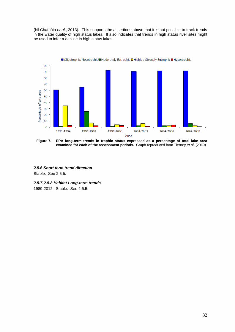
32
(Ní Chatháin et al., 2013). This supports the assertions above that it is not possible to track trends in the water quality of high status lakes. It also indicates that trends in high status river sites might be used to infer a decline in high status lakes.
Figure 7. EPA long-term trends in trophic status expressed as a percentage of total lake area
examined for each of the assessment periods. Graph reproduced from Tierney et al. (2010).
2.5.6 Short term trend direction
Stable. See 2.5.5.
2.5.7-2.5.8 Habitat Long-term trends
1989-2012. Stable. See 2.5.5.
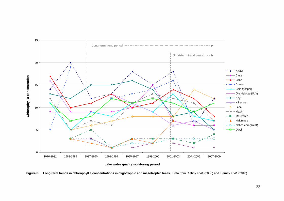
33
0
5
10
15
20
25
1976-1981 1982-1986 1987-1990 1991-1994 1995-1997 1998-2000 2001-2003 2004-2006 2007-2009
Lake water quality monitoring period
Ch
loro
ph
yll a
co
ncen
trati
on
Arrow
Carra
Conn
Coosan
Corrib(Upper)
Glendalough(Up’r)
Key
Killenure
Lene
Mask
Maumwee
Nafurnace
Nahasleam(West)
Owel
Figure 8. Long-term trends in chlorophyll a concentrations in oligotrophic and mesotrophic lakes. Data from Clabby et al. (2008) and Tierney et al. (2010).
Short-term trend period
Long-term trend period
34
2.5.9 Area of suitable habitat (km2)
It is likely that more populations of Najas flexilis will be discovered, particularly in Connemara, however there is currently no scientific basis or modelling method for identifying potentially suitable habitat.
As explained in 2.4.1a (note on population extinctions), it is possible that the species could re-establish in Lough Nafeakle, one of the three lakes in which it is now extinct.
The area of suitable habitat was, therefore, calculated to be the area of the habitat for the species (i.e. based on 58 lakes) plus the habitat in Lough Nafeakle. The surface area of Nafeakle is 0.0225 km
2 and, using the method explained in 2.5.1, the area of suitable habitat for the species is 61.4
km2, or 6,139.35 ha, based on total lake area.
2.5.10a Habitat reason for change – genuine
In 2007, the area of the habitat for the species was reported as 49.6 km2. The area reported here
is 61.4 km2.
There is no evidence of a genuine change in habitat area for Najas flexilis since 2007 or over the short- or long-term trend periods. The overall conclusion on the conservation status of the habitat of Najas flexilis is unfavourable inadequate, as it was in 2007. See 2.5.1, 2.5.4a and 2.5.5 for further information.
2.5.10b Habitat reason for change - improved/more accurate
As explained in 1.1.2, information on the distribution of the species has improved since 2007 resulting in the inclusion of habitat in additional lakes. The inclusion of these lakes accounts for an increase of 1,512.2 ha or 15.1 km
2 in the habitat area. The removal of Lough Bollard led to a
decrease of 52.6 ha or 0.52 km2, giving a net increase of 1,459.6 ha or 14.5 km
2.
2.5.10c Habitat reason for change - different method
A slight difference in surface areas of the lakes may result from the use of the updated lake segment shapefile
8. The north-western basin of Upper Lough Corrib may have been delineated
differently in 2007, resulting in different surface areas.
Assessment of habitat quality was completed in 2007 using (1) indicators recorded during Najas flexilis survey (e.g. water colour, epiphyton, phytoplankton) and (2) a review of planning applications for one-off houses (as an indicator of the risk of eutrophication from septic tanks/domestic wastewater systems). The former data were used here, in combination with water quality data reported by the Irish EPA.
See 2.5.1, 2.5.4a and 2.5.5 for further information.
2.6 Pressures
The pressures impacting on Najas flexilis are indirect, arising within the catchments of the occupied lakes, and can be broadly categorised into pollution and hydrological change. Direct impacts on the species have not been documented in Ireland, however, it is possible that some invasive species are having direct impacts.
8 [2015: Since the time of writing, map scale and version have been noted to result in significant differences in lake area,
e.g. between 1:50,000 (Discovery Series) and 1:5,000 lake polygons. Also, there is a number of different versions of the
1:50,000 data and these can vary in terms of shoreline geometry and inclusion/exclusion of islands and, therefore, area.]

35
Two main sources were used to document the pressures on Najas flexilis in Ireland:
1. The observations of Dr Cilian Roden. Dr Cilian Roden recorded evident pressures during his Najas flexilis surveys between 1999 and 2005 (Roden, 2002, 2003, 2004, 2005 and 2007). Information from a 2012 survey of Lough Corrib was also used (Roden, 2012).
2. Available spatial data. An ArcGIS project was created to assess indirect, catchment scale pressures. EPA WFD spatial data were used to identify the catchments of the Najas flexilis lakes (nested lake catchments: WFD_LakeCatchmNested.shp, lake segments: WFD_LakeSegment.shp and river segments: WFD_RiverSegment.shp). The 2005 orthophotographs were examined, as well as satellite imagery by Microsoft Bing (http://www.bing.com/maps/, data from 2012) for both the catchment as a whole and the land immediately surrounding the lake itself.
Data on pressures were captured in a spreadsheet (1833_Najas_flexilis_Pressures_Mar_2013.xls). The standard “reference list of pressures, threats and activities” was used to categorise the identified pressures. Seven of the codes covered the majority of pressures identified across the 58 catchments (see Table 8). Of these standard codes, two were further subdivided on the spreadsheet to identify the specific sources of pollution (see fourth column in Table 8). Three different invasive non-native species were identified as pressures across three lakes.
Table 8 Pressures impacting on the 58 Najas flexilis populations and their lake habitats. Based on
best-expert judgement examination of orthophotographs (2005) and satellite images (2012) for the catchments of the lakes, as well as records of pressures by Najas flexilis field surveyors. The standard “reference list of pressures, threats and activities” was used (Code and Description).
# Code Description Further divided into
Frequency of occurrence
(across catchments, n =
58)
1 H01.01 pollution to surface waters by industrial plants † 11
2 H01.03 other point source pollution to surface water ‡ 3
3 H01.05 diffuse pollution to surface waters due to agricultural and forestry activities
42
Agriculture (39)
Forestry (19)
4 H01.08 diffuse pollution to surface waters due to household sewage and waste waters
41
5 H01.09 diffuse pollution to surface waters due to other sources not listed
16
Golf courses (2)
Peat-cutting (16)
Overgrazing (1)
6 I01 invasive non-native species 3
Nymphoides peltata (1)
Elodea canadensis (1)
Dreissena polymorpha (2)
7 J02.07 Water abstractions from groundwater * 29
† Covers industrial and municipal (WWTP) wastewater discharges
‡ Used for quarry discharges only
* Used to indicate hydrological pressures arising from land drainage in the catchment. Other codes could
have been used, e.g. J02.05 'Modification of hydrographic functioning, general. Areas of wetland and other terrestrial habitats are frequently drained in Ireland for purposes such as development, agriculture, forestry and peat-cutting. Such drainage creates more direct pathways for pollutants to surface waters, as well as changing the hydrological regimes of receiving rivers and lakes and acting as sources of fine sediment. Drainage of peatland can also contribute to acidification of surface waters.
36
Most of the pressures listed in Table 8 result in increased nutrient loads and eutrophication. Increased sediment loads (leading to sedimentation and turbidity), increased water colour and acidification are other likely impacts. Further information on how these pressures can impact on Najas flexilis is given in the sub-sections below.
Of the listed pressures, the most significant in terms of both frequency of occurrence and severity (size of loads) are:
1. Diffuse nutrient pollution from agriculture (H01.05), and
2. Diffuse nutrient pollution from on-site, domestic wastewater systems (H01.08).
The next most significant impact is likely peat-cutting and peatland drainage (H01.09 and J02.07).
In addition to the above listed pressures, scraw-growth or terrestrialisation was documented as a pressure at Cregduff, and is believed to have contributed to the extinctions at Loughs Ibby and Namanawaun (see 2.4.1a). The causes of these changes are not currently known, but could be linked to drainage of the outflow (J02, human induced changes in hydraulic conditions, it is unclear which sub-code is most appropriate), siltation (J02.11.02, other siltation rate changes) and/or be part of a natural process of succession (K01.02, silting up, K01.03 drying out, K02.01, species composition change (succession), or K02.02 accumulation of organic material).
The final list of pressures reported is presented in Table 9, ranked and categorised in order of importance as required by Evans and Arvela (2011). It should be noted that selection of pressures from the standard list is particularly challenging for indirect, catchment-scale pressures and the absence of clear codes for drainage activities, in particular, is likely to give rise to significant inconsistencies among Member States and even within Member States, between habitats/species reports.
Table 9 Final list of pressures impacting on Najas flexilis. Pressures are ranked in order of
importance and categorised in accordance with Evans and Arvela (2011).
Rank Code Description Category of importance
1 H01.05 diffuse pollution to surface waters due to agricultural and forestry activities
High importance
2 H01.08 diffuse pollution to surface waters due to household sewage and waste waters
High importance
3 H01.09 diffuse pollution to surface waters due to other sources not listed*
High importance
4 J02.07 Water abstractions from groundwater * High importance
5 H01.01 pollution to surface waters by industrial plants Medium importance
6 H01.03 other point source pollution to surface water Low importance
7 I01 invasive non-native species Low importance
8 J02 human induced changes in hydraulic conditions Low importance
9 K01.02 silting up Low importance
10 K01.03 drying out Low importance
11 K02.01 species composition change (succession), Low importance
12 K02.02 accumulation of organic material Low importance
* (peat-cutting and related activities)
Eutrophication
Increased nutrient loads, particularly phosphorus but also nitrogen, appears to be the biggest pressure impacting on the species. The most common nutrient sources documented in the Najas flexilis catchments were (ranked in order of importance):
1. Agriculture
2. Domestic wastewaters from on-site systems
3. Discharges from urban wastewater treatment plants
4. Other wastewater discharges
37
5. Golf courses
6. Forestry
The impacts of nutrient enrichment on Najas flexilis have been documented in 0.2.1 and 2.5.4a. In summary, enrichment with phosphorus and/or nitrogen increases primary production of phytoplankton, epiphytic and epipelic algae and/or vascular plants (macrophytes). All of these can compete with Najas flexilis for the available resources, notably light, carbon dioxide, nutrients and space/substratum. As Najas flexilis is frequently found at the lower levels of the euphotic zone, “shading” by phytoplankton, taller rooted species or attached algae is a particular problem. Najas flexilis is generally recognised as a poor competitor (Roden, 2007, Wingfield et al., 2004). Wingfield et al. (2004) found that plants that are perennial, flower earlier than Najas flexilis and are wind pollinated had a competitive advantage over the species, most likely as a result of earlier and more efficient use of resources, shading and more reliable pollination.
Acidification
Acidification, taken here to mean decreases in pH, alkalinity and concentrations of cations such as calcium and magnesium in the water, and likely also lake sediment, appears to be impacting on Najas flexilis. The causes of these chemical changes, however, are unclear and may include a complex mix of natural as well as anthropogenic factors.
Acid episodes have been documented in Irish streams since the 1990s, and have mostly been related to storm events (Allott, et al., 1997, Kelly-Quinn, et al., 1997). Atmospheric pollution (SOX and NOX) was identified as a cause, along with deposition of sea salts and organic acids in the 1990s. Coniferous forestry was found to increase the deposition of atmospheric pollutants (Allott, et al., 1997, Kelly-Quinn, et al., 1997). There is little evidence, however, that Najas flexilis catchments are currently being acidified as a result of atmospheric pollution. Emissions of sulphur dioxide have decreased steadily since 1990 in Ireland and across the EU. Added to that, the long-term trends in precipitation and throughfall at forest plots in Ireland show a steady decrease in sulphate concentration and a rise in pH (Aherne, Johnson and Cummins, 2012
9). Three Irish lakes
have been monitored by the EPA for acid sensitivity since the late 1980s and the lakes in counties Galway and Donegal have shown no evidence of inputs of artificial acidity, while the Wicklow lake has shown distinct improvements in pH and acid-sensitive invertebrates (Tierney et al., 2010). Hence, acidification of surface waters in Ireland does not appear to be the result of deposition or scrubbing of atmospheric pollutants and the code H04.01, acid rain is not appropriate.
While organic acids were found to contribute little to acid episodes documented in the 1990s, high background levels were recorded in peatland catchments, with the highest levels found in peatland catchments with coniferous plantations (Allott et al., 1997). Recent work by Feeley and Kelly Quinn (2012
10) has demonstrated that Irish streams still experience acid episodes, but in contrast to the
1990s, the primary driver is organic acids. Recent research is also suggesting a possible influence from soil-derived sulphur.
Higher organic acid levels are unsurprising in catchments dominated by organic soils. However, disturbance of peaty soils by activities such as drainage and over-grazing, which lead to aeration and decomposition of organic matter, result in increased losses of organic acids to water. As well as leading to decreases in the pH of surface waters, disturbance to peatland typically causes increased water colour, increased particulate organic carbon and increased ammonia concentration. Drainage of peatland for peat-cutting, agriculture and forestry are the primary causes of such disturbance in Ireland. Plantation forestry on peatland appears to further increase organic acid losses through decomposition of the additional biomass produced by the trees.
The prevalence of land drainage in Najas flexilis catchments may also contribute to acidification by effectively by-passing the natural buffering capacity within a catchment. Drains shorten the hydrological pathway for rainfall to surface waters and, therefore, reduce the potential for infiltration to soils and subsoils. To put it another way, the purpose of drainage in Ireland is to lower the groundwater level, therefore shallow sub-surface flow paths are either by-passed or more rapid. The result is that the dissolution of cations by rainwater from any mineral soils or subsoils or base-rich bedrock is reduced.
9 pp 175-204 http://www.ucd.ie/hydrofor/docs/HYDROFOR_Workshop.pdf
10 pp 205-239 http://www.ucd.ie/hydrofor/docs/HYDROFOR_Workshop.pdf
38
Localised acidification of Najas flexilis lakes could occur, therefore, as a result of inputs of organic acids and reduced buffering capacity owing to drainage and disturbance of peatlands. Different processes may result in the acidification of coastal lakes that rely on inputs of sea-spray and wind-blown sands for their cation supply. Management of coastal dune systems is likely to be key to the supply of coastal sands, where it serves to promote exposure and/or erosion of sand. Inter-annual variations in weather patterns will also affect the delivery of wind-blown sand and sea-spray to coastal Najas flexilis lakes.
The impacts of acidification on Najas flexilis have been explained in 0.2.1. In summary, the species’ reproductive capacity declines with increased acidification and, consequently, it becomes less abundant at lower pH (Roden, 2004, Wingfield et al., 2004). Year to year fluctuations in pH, alkalinity and calcium could, as a result, promote genetic drift and loss of genetic diversity in the species (Wingfield et al., 2004).
Peat cutting
The likely acidification impacts arising from peatland drainage have been detailed above. Decomposition of peat can also contribute to the problem of eutrophication by increasing concentrations of ammonia in surface waters. Dissolved and particulate organic carbon can increase production by heterotrophs, resulting in extensive fungal, bacterial and algal growths on river beds and potentially increasing the supply of nutrients to downstream lakes. Water draining disturbed peatland also has higher colour. Drainage of peatlands and peat-cutting, in particular, are significant sources of particulate matter that can increase lake turbidity and settle on the lake substratum. Increased water colour and turbidity decrease light penetration and could reduce the area of available Najas flexilis habitat at the lower euphotic depths. Particulate peat produces a relatively unstable substratum and macrophytes are generally sparse or absent from lakes with significant volumes of peat sediment. In one Irish lake, Dahybaun, the lake bed is covered in deep deposits of unconsolidated peat from the adjacent peat-workings and Najas flexilis is one of the few macrophytes that appears to have adapted to the unstable conditions. As it grows as isolated plants in Dahybaun, however, it cannot be concluded that the peat sediment has not had a negative impact on Najas flexilis.
Invasive non-native species
Invasive non-native species are renowned as one of the most signifiant pressures on biodiversity generally, and freshwater systems, in particular. “Invasives” by definition show periods of extremely high biomass or population explosions and are certainly very obtrusive. However and surprisingly, the exact ecological impacts of invasives are often poorly understood. Furthermore, the relationships between other pressures, most notably for freshwaters that of eutrophication, and the responses of invasive species are often overlooked.
Wingfield et al. (2004) looked at competition from Elodea spp. and considered that the potential impact on Najas flexilis was likely dependent on time since introduction and lake morphology (worst in small, shallow lakes). There is limited direct evidence of Elodea spp. impacting on Najas flexilis. Wingfield et al. (2004) noted an impact in Tangy Loch in Scotland, while Roden (2004) considered it a possible factor in the species’ decline in Tully Lough. By contrast, Benthic Solutions (2007) considered Elodea spp. had not significantly impacted on Najas fleixilis in five Pertshire Lochs, as a result of niche-separation. Wingfield et al. (2004) documented the co-occurrence of Najas flexilis and Elodea canadensis at eight mainland Scottish lochs and Elodea nuttallii at seven without any evidence of significant impacts. Roden (2004) recorded Elodea canadensis at three additional Najas flexilis lakes without any evidence of impact. For this assessment, therefore, Elodea canadensis is only considered a pressure at Tully Lough.
Another macrophyte species, Nymphoides peltata, has been found in localised high abundance on the eastern shores of Lough Leane. While no direct impacts on Najas flexilis have been formally documented, the distribution of this non-native species overlaps very closely with that of the Annex II species, notably south-east of Ross Island and near the Muckross House boathouse. Nymphoides peltata has very dense floating leaves and flowers and clear potential to ‘shade’ fully submerged macrophytes like Najas flexilis, as well as compete for space and nutrient resources.
39
Interestingly, Wingfield et al. (2004) noted competition by the native species Myriophyllum alterniflorum and Chara spp. as possibly impacting on Najas flexilis in Loch nam Cnamh, Scotland. Competitaion from native species could be part of a natural lake-succession or, more likely, promoted by environmental distrubances such as eutrophication. Eutrophication will inevitably convey an advantage on invasive non-native and native perennial species. Wingfield et al. (2004) observed that competition is not always a problem, but is more likely to be where nutrients and light promote excessive growth.
Zebra mussels (Dreissena polymorpha) occur in Tully and Corrib. The impact of zebra mussels on Najas flexilis is unknown and likely complex. On one hand, the filtration of phytoplankton leading to higer water transparency and the diversion of nutrients to benthic-cycling may benefit Najas flexilis. On the other, there is incresing evidence of zebra mussels colonising fine substratum and vegetation where nutrients are in abundance and, here, they could directly compete with Najas flexilis for habitat. Higer water transparency and more abundant benthic nutrients is also likely to promote the growth of pondweeds and other macrophyte species that can out compete Najas flexilis. Roden (2012) documented very low water transparency (Secchi depth), high water colour, peat sediment, shallow submerged vegetation zone, sparse macrophyte vegetation generally and abundant zebra mussels (on exposed hard surfaces) in the north-western by of Upper Corrib in which Najas flexilis was recorded in 1986.
2.6.1 Methods used – Pressures
See 2.6. 2 – Mainly based on expert judgement and other data
2.7 Threats
All pressures documented at 2.6 were also listed as threats (Table 10). In addition, climate change was identified as a threat (Table 10).
Table 10 Final list of threats expected to impact on Najas flexilis. These are categorised
in accordance with Evans and Arvela (2011).
Code Description Category of importance
H01.05 diffuse pollution to surface waters due to agricultural and forestry activities
High importance
H01.08 diffuse pollution to surface waters due to household sewage and waste waters
High importance
H01.09 diffuse pollution to surface waters due to other sources not listed*
High importance
J02.07 Water abstractions from groundwater * High importance
H01.01 pollution to surface waters by industrial plants Medium importance
M01 Changes in abiotic conditions Medium importance
H01.03 other point source pollution to surface water Low importance
I01 invasive non-native species Low importance
J02 human induced changes in hydraulic conditions Low importance
K01.02 silting up Low importance
K01.03 drying out Low importance
K02.01 species composition change (succession), Low importance
K02.02 accumulation of organic material Low importance
* (peat-cutting and related activities)
Climate change
Climate change has the potential to exacerbate many of the current pressures and may already be having an impact on the species. It has not been included as a pressure in 2.6, however, as it has not been formally documented as impacting on Najas flexilis.
40
Predictions for the future climate of Ireland generally agree on increases in average annual precipitation and air temperatures, and a likely increase in storm events. There is less agreement as to the geographical or seasonal variations, however it seems likely that increases in precipitation and storms will be greatest along the west coast, particularly the North West; the areas in which Najas flexilis occurs. A recent review of meteorological data demonstrates:
o An increase in the number of warm days (those with temperatures over 20 C) in the period 1961 to 2010
o A decrease in the number of frost days (those with temperatures below 0 C) in the period 1961 to 2010
o The annual average surface air temperature has increased by approximately 0.8 C over the last 110 years
o A rise in temperatures in all seasons
o A 60 mm or 5% increase in annual average rainfall for the period 1981 to 2010 in comparison to the 30-year period 1961 to 1990
o In general, larger increases in rainfall amounts in the western half of the country
o Some conflicting patterns in the number of wet days (days with rainfall greater than 0.2 mm) and heavy rain days (days with rainfall greater than 10 mm), but an apparent increase in both in the west, particularly mid and north west
(Dwyer, 2013).
The likely impacts of temperature increases on Najas flexilis are difficult to predict, but may include earlier germination. Temperature change will also affect other plant species and could influence competition for resources and the spread and abundance of non-native invasive species. Increased rainfall and, in particular, an increase in storm events are likely to increase the losses of dissolved and particulate nutrients to water. Storm surges would put particular pressure on domestic on-site and urban/industrial wastewater treatment systems. An increase in surface run-off would result in an increase in direct losses of organic and chemical fertilisers from agricultural and forestry lands. These scenarios would increase eutrophication pressures on Najas flexilis.
Warmer temperatures and greater seasonal variations in rainfall (droughts and floods) are likely to increase the decomposition of damaged peatlands and losses of organic acids, particulate organic matter, colour and ammonia to water, further increasing eutrophication, sedimentation and acidification pressures. As acid episodes in Irish rivers are related to rainfall events, changes in precipitation and, in particular, storm events, is a significant concern.
An increase in storms along the west coast could influence coastal erosion and the provision of wind-blown sand; a possible positive impact on Najas flexilis.
Consequently, the codes M01.03, flooding and rising precipitation, M01.02, droughts and less precipitation, M01.04, pH changes, M01.05, water flow changes and M01.01, temperature changes may all be relevant, however for the purposes of the report the overarching level two category, M01, changes in abiotic conditions, is used.
It is recommended that the influence of climate changes on the species should be monitored.
2.7.1 Threats - method used
See 2.7. Expert opinion.
2.8.1 Justification of % thresholds for trends
The data available for Najas flexilis did not support analyses to determine trends at a resolution as fine as 1% per annum. Available trend data were used, in so far as possible, with expert judgement.
2.8.2 Other relevant information
Range
The current methods for assessing the conservation status of the range, based on area of the range as calculated using the Range Tool, lack sensitivity to change, not least because:

41
o changes in the range tool lead to changes in the area of the range for even a stable distribution,
o the use of hectads/ 10 km-squares to map the species’ distribution is likely to artificially increase the calculated area of the range,
o there is a lack of consideration of local/regional variation, o there is a lack of consideration of the significance of the losses in terms of biological,
morphological, geological, hydrological, altitudinal, climatic or other variations, o there is a high probability that the favourable reference range will continue to change,
owing to improvements in knowledge. Population
Significant difficulties were encountered with estimating the number of mature individuals of Najas flexilis. Surveying the species is very challenging, as it is a submerged, relatively small macrophyte that can grow at depths of up to 10 m below the water surface in lakes. Counting the number of individual plants is possible for a small number of sub-samples only and can only be achieved while snorkelling or SCUBA-diving. Added to that, the plant has a short annual life-cycle, and varies considerably, both spatially and temporally, in density. Each difficulty introduces uncertainty, meaning it is likely to be impossible to make statistically robust estimates of the number of mature individuals. Furthermore, even with statistically robust estimates, separation of the natural fluctuations in population size from those driven by anthropogenic pressures would be very challenging and require intensive, long-term research and monitoring. Therefore, assessment of the conservation status of the national Najas flexilis population based on the number of mature individuals is not reliable. A simple and effective means of assessing the national Najas flexilis population would be to monitor population continuity/extinction and report on the number of extant populations (one lake = one population). National population status could also be assessed based on the condition and viability of individual populations, which would require assessment of factors such as plant fitness, horizontal and vertical distribution and abundance.
The population estimates provided, both for the national population and the within-SAC-network population, were reported using the standard population classes. All national and within-SAC-network estimates fell within the Size Class 7. This does not mean that all Najas flexilis plants are within the SAC network. The within-SAC population estimates represented between 80% and 86% of the national estimates. 47 of the 58 extant Najas flexilis populations are within 26 SAC. 24 of these SAC are selected for the species and these contain 45 Najas flexilis populations. Habitat for the species
Area of the habitat is generally an insensitive measure for the conservation status of the habitats of freshwater species. Lakes can be ‘created’ by the damming of rivers or reduced in area by drainage or, for small and shallow lakes, by processes of natural succession, however such changes are typically so small that they are ‘lost’ in a national report on habitat area. Habitat quality is, therefore, the key measure of the conservation status of the Najas flexilis habitat.
Significant quantities of data are available on water quality, particularly in relation to the eutrophication of lakes, however these data are classified in accordance with general water quality objectives and do not take into consideration the specific requirements of protected species. As a consequence, the variables (quality elements) or the thresholds used may be inappropriate to assessing the quality of the Najas flexilis habitat. In particular, it is thought likely that Najas flexilis may tolerate or even reach optimal densities in lakes that are above the oligotrophic boundary in terms of dissolved nutrients and, hence, that the high status (oligotrophic) targets used here may be overly stringent. This approach was preferable, however, to adopting the alternative target of the eutrophic boundary, as it is clear that Najas flexilis can be impacted by eutrophication well below this latter threshold.
Further surveillance of population and habitat condition is necessary to determine whether the WFD quality elements are appropriate measures for the habitat of Najas flexilis and whether the WFD boundaries can be used to determine that habitat’s condition. Pressures and Threats
The standard EU codes were considered particularly problematical for freshwater habitats and species, such as Najas flexilis, as most/all pressures act indirectly (e.g. hydrological change,
42
nutrient pollution, sediment pollution, acidification). The pressures are frequently diffuse, and arise as a result of a number of developments and activities from a variety of sectors. Impacts are almost always the result of cumulative pressures, and interactions among pressures are frequently complex and can be difficult to predict. In general, the standard list is too long, allowing multiple codes to be used to cover one pressure. The option of using a pollution qualifier further adds to the confusion and has been avoided here. By contrast, the absence of a clear code for the pressures associated with land drainage was disappointing. The absence of clear codes for drainage activities, in particular, is likely to give rise to significant inconsistencies among Member States and even within Member States, between habitats/species reports.
2.8.3 Trans-boundary assessment
Not applicable
2.9.1a Conclusion Range
Najas flexilis occurs in 58 lakes in counties Donegal, Leitrim, Mayo, Galway and Kerry. Most are located near the western coast and Connemara appears to be the species’ Irish stronghold. Knowledge of the species’ range has improved since 2007 owing to additional survey work and collation of historical records. There has been no real expansion in the species’ range and all populations are considered to be post-glacial relicts. The range was mapped using the Range Tool and a distribution based on the polygons for occupied lakes.
As the current range is equal to the favourable reference range (FRR) and there is no evidence of a change in the species’ range since the Directive came into force, the range for Najas flexilis is assessed as favourable.
2.9.1b Conclusion - range qualifier
Stable
2.9.2a Conclusion - population
The number of mature individuals of Najas flexilis was estimated at between Class 7 and Class 8, based on data from the period 1999-2005. As there are no reliable methods for calculating the number of Najas flexilis plants in a lake and it is unlikely that reliable, statistically robust population estimates can ever be derived for a relatively short-lived, annual species that can grow down to depths of 10m in lakes, the number of mature individuals is considered to be an inappropriate measure for assessing the conservation status of the population.
58 populations (or 58 individual lakes) are considered to be extant. This is an increase from the 46 reported in 2007. This is not the result of colonisation of new lakes, rather improved knowledge of the species’ distribution. Three populations are considered to have gone extinct before the Directive came into force (most likely in the 1970s or earlier).
The status of 16 of the 58 populations is uncertain. Despite dedicated Najas flexilis and/or general macrophyte surveys, the species has not been re-found in these lakes. As a result, the status of the Najas flexilis population is assessed as unfavourable inadequate.
2.9.2b Conclusion - population qualifier
Stable (low confidence)
2.9.3a Conclusion - habitat
Data on biological quality and nutrient conditions were available for half or the Najas flexilis lakes from the Irish EPA’s WFD lake monitoring programme. Conservative Najas flexilis targets were set for each quality element, essentially corresponding to oligotrophic conditions, and the lakes were classified as favourable, poor and bad habitat condition. 55 % of the monitored lakes were in poor condition and 24% in bad condition, however, taking into consideration that the classification may have been overly stringent and that there were no monitoring data for 29 of the lakes, the habitat for the species is assessed as unfavourable inadequate.
43
2.9.3b Conclusion - habitat qualifier
Stable as there is no evidence of loss of any areas of the species’ habitat and based on national trends in the trophic status of monitored lakes.
2.9.4a Conclusion - future
Given the unfavourable inadequate status of the population and habitat of Najas flexilis, the pressures and threats identified and, in particular, the concern as to the status of 16 of the 58 extant populations, the future prospects are assessed as unfavourable inadequate.
2.9.4b Conclusion - future qualifier
Pollution from once-off houses appears to be a relatively greater pressure on Najas flexilis lakes than Irish lakes generally. As a result, the National Inspection Plan for inspection of domestic wastewater treatment systems (DWWTS) should, with time, lead to reductions in losses from existing houses. Economic pressures should also reduce the number of new houses proposed, while new guidelines and risk assessment tools should ensure any new houses built will not result in additional pollution loads. It must be recognised, however, that a very large number of system need to be inspected nationally and that this will take a significant amount of time. There is also uncertainty as to the availability of resources for the necessary system upgrades. The results of this assessment show that the catchments of Najas flexilis lakes should be highlighted as requiring inspection of DWWTS. They will, however, have to compete in the prioritisation process with other significant conservation concerns, drinking waters and health considerations.
It must also be stated that agriculture is still the greatest exporter of phosphorus to surface waters in Ireland, and that current agricultural policy supports food production and land intensification. Furthermore, there is no national agricultural scheme to support farming for conservation.
Significant national investment in municipal wastewater treatment, combined with regulation of such discharges by the EPA, has resulted in significant improvements in water quality across Ireland. Financial resources for further necessary improvements in sewage networks and treatment facilities must, however, be in doubt.
Conservation actions to rehabilitate and restore blanket bogs (Reasoned opinion 2010/2161) and ongoing measures to combat overgrazing of upland and peatland resources may help reduce the pressures from peatlands in some Najas flexilis catchments. However, economic pressures are apparently increasing the reliance on relatively cheap fuels such as turf, while afforestation and agricultural reclamation of peat and peaty soils is ongoing and has increased in some parts of the west, in particular.
Combined with the threats posed by climate change, therefore, it would appear overall that without dedicated conservation programmes for the species, the pressures on Najas flexilis will most likely remain stable or possibly increase in the future. Owing to the lack of information on the condition of the populations, the lack of clear evidence linking the environmental indicators used and population decline and the apparent persistence of populations in the face of significant pressures, the future prospects are assumed to be stable.
2.9.5 Conclusion Overall assessment
The overall conservation status of Najas flexilis is assessed as unfavourable inadequate.
2.9.6 Conclusion Overall assessment trend
The overall trend is considered to be stable. However, confidence in the trend is low owing to the uncertainty on the status of 16 populations and the prediction that pressures are most likely to increase on the species in the future.
3.1.1 a) Natura 2000 surface area min
Population Class 7, 10,000 to 50,000
47 Najas flexilis lakes (or 81%) are found within 26 Special Areas of Conservation (SAC) (See Table 11). 45 of these lakes (or 78%) are found within the 24 Special Areas of Conservation (SAC) listed for the species (See Table 11). The SAC where Najas flexilis is a qualifying interest are:
1. 000147, Horn Head and Rinclevan SAC
44
2. 000164, Lough Nagreany Dunes SAC
3. 000185, Sessiagh Lough SAC
4. 000197, West of Ardara/Maas Road SAC
5. 000297, Lough Corrib SAC
6. 000365, Killarney National Park, Macgillycuddy's Reeks and Caragh River Catchment SAC
7. 001141, Gweedore Bay and Islands SAC
8. 001151, Kindrum Lough SAC
9. 001251, Cregduff Lough SAC
10. 001311, Rusheenduff Lough SAC
11. 001342, Cloonee and Inchiquin Loughs, Uragh Wood SAC
12. 001919, Glenade Lough SAC
13. 001932, Mweelrea/Sheeffry/Erriff Complex SAC
14. 001975, Ballyhoorisky Point to Fanad Head SAC
15. 002008, Maumturk Mountains SAC
16. 002031, The Twelve Bens/Garraun Complex SAC
17. 002034, Connemara Bog Complex SAC
18. 002074, Slyne Head Peninsula SAC
19. 002111, Kilkieran Bay and Islands SAC
20. 002118, Barnahallia Lough SAC
21. 002119, Lough Nageeron SAC
22. 002130, Tully Lough SAC
23. 002176, Leannan River SAC
24. 002177, Lough Dahybaun SAC
Based on the population estimates of Roden (2004) and the methods detailed at 2.4.1a, the population estimate for the 47 lakes within the SAC network were 18,082, using the median population estimate, and 29,107, using the average population estimate. These correspond to 86 % and 80 % of the total national estimates using the same methods.
The within SAC network population estimates using the estimates of Roden (2007) were again larger at 37,003, based on median, and 33,153, based on average and corresponded to 85 % of the national estimates (see 2.4.1a).
Using these same two methods for the 45 lakes within the 24 SAC where Najas flexilis is a qualifying interest, the estimates are:
1. Based on Roden (2004):
a. 17,932, or 85% of the national population, based on median population estimate,
b. 28,432, or 78% of the national population based on the average population estimate.
2. Based on Roden (2007):
a. 35,003 or 80% of the national population, based on median
b. 31,853 or 83% of the national population, based on average.
Table 11 Najas flexilis populations protected within the SAC network. Grey font indicates
Najas flexilis is not a qualifying interest of the SAC.
Lake Name EPA Lake Code
SAC Code
SAC Name
Port NW_38_637 000147 Horn Head and Rinclevan SAC
Nagreaney NW_38_186 000164 Lough Nagreany Dunes SAC
Sessiagh NW_38_61 000185 Sessiagh Lough SAC
Clooney NW_38_542 000197 West of Ardara/Maas Road SAC
Kiltooris NW_38_47 000197 West of Ardara/Maas Road SAC
Sheskinmore NW_38_545 000197 West of Ardara/Maas Road SAC
Corrib WE_30_666b 000297 Lough Corrib SAC

45
Lake Name EPA Lake Code
SAC Code
SAC Name
Acoose SW_22_208 000365 Killarney National Park, Macgillycuddy's Reeks and Caragh River Catchment SAC
Adoolig SW_21_372 000365 Killarney National Park, Macgillycuddy's Reeks and Caragh River Catchment SAC
Caragh SW_22_207 000365 Killarney National Park, Macgillycuddy's Reeks and Caragh River Catchment SAC
Leane SW_22_185 000365 Killarney National Park, Macgillycuddy's Reeks and Caragh River Catchment SAC
Long Range SW_22_187 000365 Killarney National Park, Macgillycuddy's Reeks and Caragh River Catchment SAC
Muckross SW_22_184 000365 Killarney National Park, Macgillycuddy's Reeks and Caragh River Catchment SAC
Upper Lake SW_22_186 000365 Killarney National Park, Macgillycuddy's Reeks and Caragh River Catchment SAC
Mullaghderg (East) NW_38_81 001141 Gweedore Bay and Islands SAC
Mullaghderg (West) NW_38_85 001141 Gweedore Bay and Islands SAC
Kindrum NW_38_670 001151 Kindrum Lough SAC
Cregduff WE_31_1116 001251 Cregduff Lough SAC
Rusheenduff WE_32_434 001311 Rusheenduff Lough SAC
Cloonee Middle SW_21_446 001342 Cloonee and Inchiquin Loughs, Uragh Wood SAC
Keel WE_33_1895 0015113 Keel Machair/Menaun Cliffs SAC
Glenade WE_35_156 001919 Glenade Lough SAC
Fin Lough WE_32_391 001932 Mweelrea/Sheeffry/Erriff Complex SAC
Nahaltora WE_32_472 001932 Mweelrea/Sheeffry/Erriff Complex SAC
Shannagh NW_38_678 001975 Ballyhoorisky Point to Fanad Head SAC
Lehanagh WE_31_152 002008 Maumturk Mountains SAC
Kylemore WE_32_509b 002031 The Twelve Bens/Garraun Complex SAC
Pollacappul WE_32_509a 002031 The Twelve Bens/Garraun Complex SAC
Anillaunlughy WE_31_169 002034 Connemara Bog Complex SAC
Derrywaking WE_32_346 002034 Connemara Bog Complex SAC
Lough Bofin WE_30_335 002034 Connemara Bog Complex SAC
Lough Sruffauncam WE_32_335 002034 Connemara Bog Complex SAC
Maumeen WE_31_189 002034 Connemara Bog Complex SAC
Nalawney WE_31_35 002034 Connemara Bog Complex SAC
Truska Lough WE_31_1063 002034 Connemara Bog Complex SAC
Easerd WE_31_211 002074 Slyne Head Peninsula SAC
an Chaolaigh WE_31_982 002111 Kilkieran Bay and Islands SAC
Keeraun WE_31_1029 002111 Kilkieran Bay and Islands SAC
Natawnymore WE_31_1106 002111 Kilkieran Bay and Islands SAC
Truskan WE_31_62 002111 Kilkieran Bay and Islands SAC
Barnahallia WE_32_269 002118 Barnahallia Lough SAC
na gCaor Loch WE_31_142 002119 Lough Nageeron SAC
Tully WE_32_474 002130 Tully Lough SAC
Akibbon NW_39_11 002176 Leannan River SAC
Fern NW_39_13 002176 Leannan River SAC
Dahybaun WE_33_1912 002177 Lough Dahybaun SAC
Lough Derg NW_01_115 002301 River Finn SAC
3.1.1 b) Natura 2000 surface area max
Guidance - See 3.1.1 a)
46
3.1.2 Natura 2000 Method used
Guidance - This should have been expanded on in 3.1.1 a).
2 - Estimate based on partial data with some extrapolation and/or modelling
3.1.3 Natura 2000 trend used
The available population data do not allow comparison of trends within and outwith the SAC network. There is no apparent difference in habitat quality inside or outside the network. Therefore the same trend is used as for population and habitat generally, i.e. stable.
3.2 (Conservation) Measures
Three conservation measures were selected from the standard list (see Table 12).
Najas flexilis and its habitat are protected under the Wildlife Acts, Flora Protection Order 1999 (S.I. No. 94) (Measure 6.3). This affords protection against collection and direct damage to the species and its habitat. As detailed in 2.6, however, the pressures on Najas flexilis are primarily indirect and cannot be addressed through legal protection alone.
The species is protected through the Natura 2000 network where it is listed as a qualifying interest for the SAC (Measure 6.1). Conservation objectives for Najas flexilis in these SAC afford protection against proposed developments and activities, both within the designated site and the wider catchment, through Article 6 (3). There are, however, no conservation measures currently being undertaken to restore or enhance populations of Najas flexilis within SAC. More detailed surveillance of the populations and their habitat would be required before such measures could be planned.
Table 12 Conservation measures for Najas flexilis. These are ranked in order of importance.
Code Measure Type Ranking Location Comment
6.3 Legal protection of habitats and species
Legal/statutory H both inside and outside network
Protected under Wildlife Acts (Flora Protection Order) MAINTAIN
4.1 Restoring/improving water quality
Legal/statutory H both inside and outside network
WFD RBMPs. LONG-TERM. Sub-basin Management Plans likely to be required for Najas flexilis lakes to restore to favourable condition.
6.1 Establish protected areas/sites
Legal/statutory H Inside the network
SAC Network. MAINTAIN.
The Water Framework Directive provides the legal and administrative mechanism for maintaining and enhancing water quality. The measures implemented under the current and future River Basin Management Plans (RBMPs) will help improve surface waters that are in moderate poor or bad status and help prevent deterioration in those in high or good status. The implementation of many WFD measures will take some time (e.g. inspection and upgrade of domestic on-site wastewater systems, or upgrading urban wastewater collection and treatment systems) and, as a result, water quality improvements will not become apparent in the short-term. The current RBMP measures are likely to be insufficient to protect Najas flexilis, however, for a number of reasons, most notably:
1. If, as assumed here, high status is required by Najas flexilis, then the objective of good status, which applies to all lakes not currently at high status
11, will not allow for restoration
of the species’ habitat.
11
Based on the EPA 2007-2009 final status, the objective of good status applies to 27 or 64% of the 42 listed Najas flexilis lakes
47
2. The agricultural measures are currently restricted to implementation of the Nitrates Action Programme. It is unlikely that this programme will support the achievement of even good status in areas of Ireland with high rainfall and/or organic soils. Given that the majority of phosphorus lost to surface waters has an agricultural origin, this is a significant concern and means that the current measures may not even succeed in preventing further deterioration of lake water quality.
3. There are currently no measures to address the impacts of drainage on surface waters.
It is assumed, therefore, that current and future RBMP cycles will lead to a gradual reduction in pressures from domestic on-site and municipal wastewaters. Unless an objective of high status is established for Najas flexilis lakes, the standards applied to such wastewaters may not be sufficiently stringent. It is likely that maintenance or restoration of Najas flexilis habitat quality will require dedicated Sub-basin Management Plans with more stringent objectives and specific measures to address catchment-specific pressures, particularly diffuse pollution from agriculture, forestry and peat-cutting, and hydrological and acidification pressures associated with peatland drainage.
Acknowledgements
Very many people have contributed to this assessment, not least those who have recorded the species, notable amongst whom is Cilian Roden. Cilian is also ever generous with his knowledge and expert advice. I am extremely grateful to Richard O’Callaghan for his time, patience and efforts in producing the excellent new database of Najas flexilis records. Particular thanks are also due to my colleagues Gemma Weir, Jim Ryan, Deirdre Lynn and Mike Wyse Jackson. Many from the current and past EPA staff have supplied data and advice, including Deirdre Tierney, Rosanna Caroni, Karen Donnelly, Gary Free, Bryan Kennedy, Ruth Little, Caroline Plant, Fiona O’Rourke, Wayne Trodd and Katherine Webster. Thanks also to Norman Allott (TCD), Donal Casey, Tony McNally and Karen McBride (Donegal Co. Co.), Mick Boyce and David Lenihan (Kerry Co. Co.).