Embed Size (px)
Citation preview
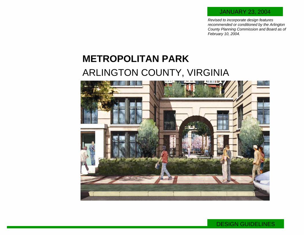
METROPOLITAN PARKARLINGTON COUNTY, VIRGINIA
DESIGN GUIDELINES
JANUARY 23, 2004Revised to incorporate design features recommended or conditioned by the Arlington County Planning Commission and Board as ofFebruary 10, 2004.
TABLE OF CONTENTS
PrefaceFramework PlanStreet ClassificationCirculation: Pedestrian, Vehicular BicycleEntrances: Residential, Parking, ServicePhasing
OverviewStreet Sections:
12th Street Extended15th StreetSouth Fern Street South Eads Street Elm and 14th Streets13th StreetEast and West Elm StreetTypical Tertiary Streets
Open SpacePublic ArtBuilding Guidelines
Height and MassingArchitectural ElementsMaterialsGround Floor Retail Characteristics Signage
Landscape Guidelines:Streetscape FeaturesPedestrian Arcade DetailCrosswalk Plan Plant Materials
Quality and SizeSoil Over Structure
Suggested Plant Species Street Furniture Illustratives:
Benches and TablesLighting and Trash Receptacles
3-1213-14
151616
18
1919202021222324
25-2627-28
2930303132
33-363738
4040
41-42
4344
2METROPOLITAN PARK
Purpose and Intent • The Metropolitan Park Design Guidelines have been derived from
design principles that were identified and discussed in a companion Project Book dated November 12, 2003. The guidelines in this book detail the pattern of development for this future residential community, and establish standards for streets, buildings, open space, and landscaping as a means of insuring quality and consistency as phased development proceeds over time.
• This Design Guidelines document and its companion Project Book represent the evolution of Pentagon City planning and development and set the stage for the completion of the residential component of the Pentagon City Plan.
• Sufficient detail is provided in the Design Guidelines document for the community and residents to know the quality of development which is expected, but not so rigid as to stifle design and innovation for the future.
• The Design Guidelines insure a level of quality which can be easily referenced for future buildings.
• This Design Guidelines document is to be adopted by reference into the County Board approval of the Planned Development Site Plan (PDSP) for Pentagon City.
Revised as of February 10, 2004
3 Revised as of February 10, 2004
4
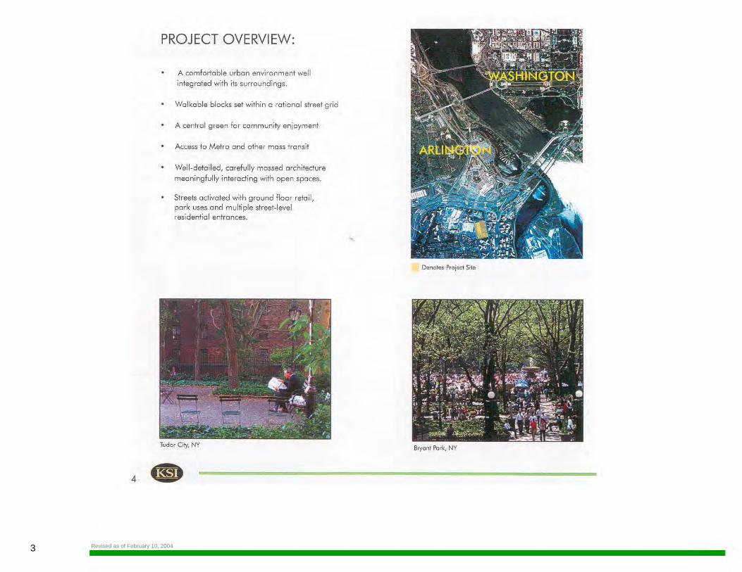
PROJECT OVERVIEW:
A comfortable urban environment well
integrated with its surroundings.
Walkable blocks set within a rational street grid
A central green for community enjoyment
Access to Metro and other mass transit
Well-detailed, carefully massed an;hitecture
meaningfully interacting with open spaces.
Streets activated with ground floor retail, park uses and multiple street-level residential entrances.
Tudor City, NY
Denotes Project Site
Bryant Park, NY
4METROPOLITAN PARK
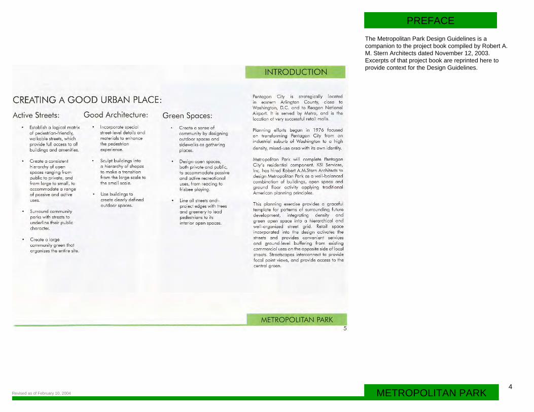
PREFACEThe Metropolitan Park Design Guidelines is a companion to the project book compiled by Robert A. M. Stern Architects dated November 12, 2003. Excerpts of that project book are reprinted here to provide context for the Design Guidelines.
Revised as of February 10, 2004
5 Revised as of February 10, 2004
a G& MURRAY H. PARK (Poss~
D RETAIL D WAREHOUSE
D RESIDENTIAL D GOVERNMENT
D MIXED USE D PARK
D HOTEL D OFFICE 8.
Warehouses on Site
Pentagon Centre (Costco)
Use Plan: Scale 1"=800' ~
Surrounding Highrise Residential Towers

PREFACE
6METROPOLITAN PARKRevised as of February 10, 2004
Aerial photo showing proiect site
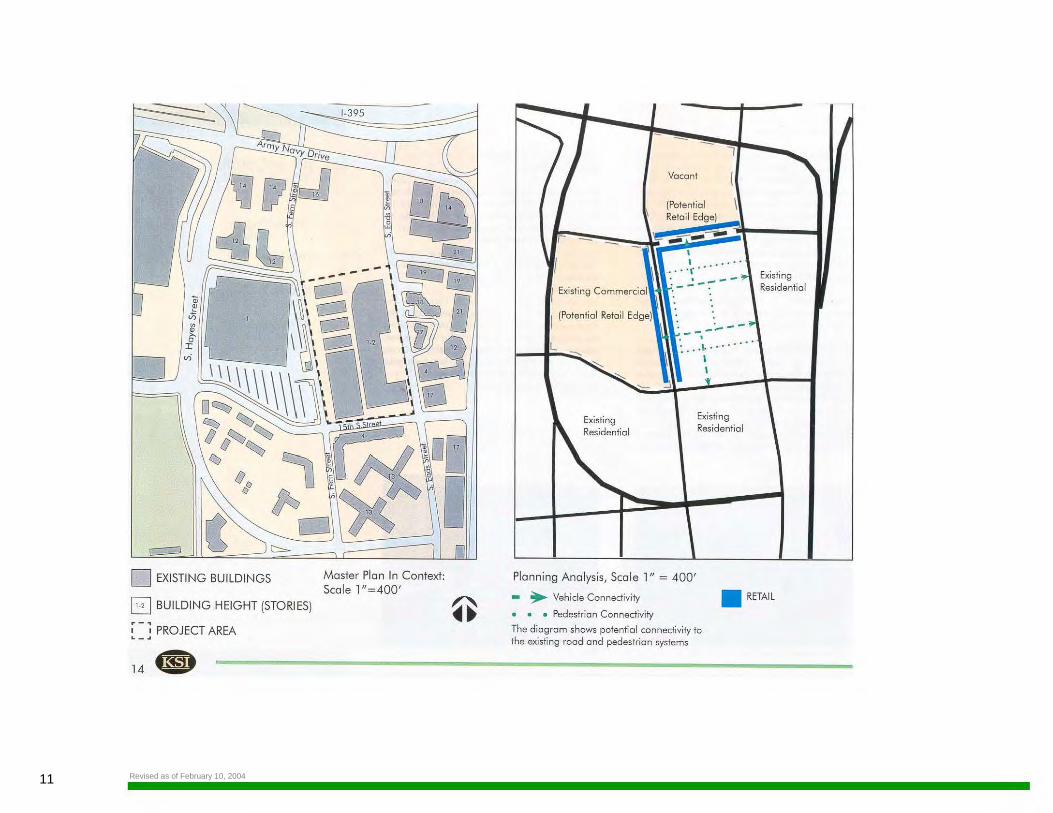
The Site and its Context
Current Development Patterns:
Many wide streets and large blocks favor vehicles over pedestrians
Limited relationships between buildings and roads.
Limited connection between open spaces and buildings.
A suburban land use pattern that has recently reached urban density.
Lorge, strategically located parcels of land that offer significant opportunities to carry out planned development
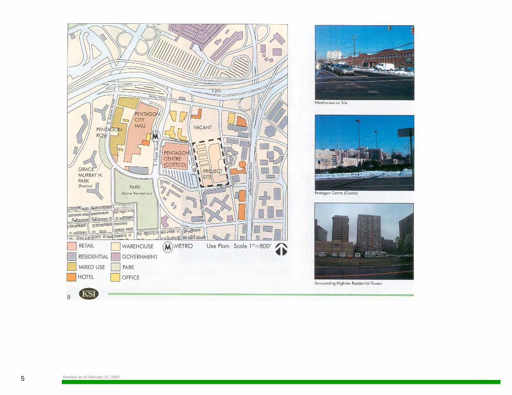
The project site comprises a 16-acre warehouse facility that was built in the l 950's. A variety of uses exist in the area: largely vacant land to the north, high rise apartments and a bank ta the east across South Eads Street, high-rise and mid-rise residential buildings to the south across 1 S'h Street, and a Costco warehouse store in the Pentagon Centre development to the west across South Fern Street. Pentagon Row and the Pentagon City Fashion Moll ore located to the west, beyond Costco. Crystal City and Reagan National Airport ore located farther to the east and southeast respectively. The adjacent rood network operates at acceptable levels of service.
The site is located between two Metro stations. The Pentagon City Metro Station entrance is located at 12th Street and South Hayes Street, and the Crystal City Metro Station entrance is located at South Eads Street south of 15th Street.
Porks and recreation facilities in the area include an 11 acre active recreation pork with ball fields to the west across 1 Sth Street, the two-acre Groce Murray Hopper passive pork in front of the River House a lso lo the west across 15•h Street, and the Pentagon Row Plaza pork which hosts a skating rink during the winter months.
SITE SUMMARY
The Site and its Context
Surrounding Land Use
Existing Open Space
Current Use of Site
METROPOLITAN PARK 9
7 Revised as of February 10, 2004
I t:>
PDSP - PHASED DEVELOPMENT SITE PLAN
10.
-
Metro Access
Site view from Pentogon Centre (Cosico)
0 /'-....
~ .. ~ Scale 1"=400'
Alley running through site
PREFACE
8METROPOLITAN PARKRevised as of February 10, 2004
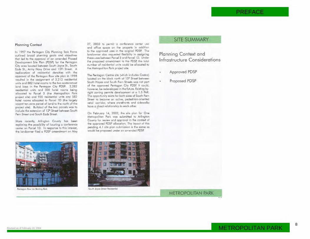
Planning Context
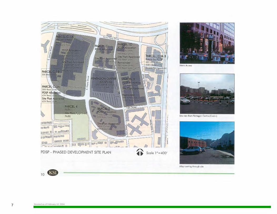
In 1997 the Pentagon City Planning Task Force outlined brood planning goals and objectives that led to the approval of on amended Phased Development Site Pion (PDSP) for the Pentagon City area located between South Joyce St., South Eads St., Army Novy Drive and 15th Street. A reallocation of residential densities with the approval of the Pentagon Row site pion in 1998 resulted in the assignment of 3,212 residential units and 882 hotel rooms to the two easternmost lond boys in the Pentagon City PDSP: 2,282 residential units and 300 hotel rooms being allocated to Parcel 3 (the Metropolitan Pork project site) ond 930 residential units and 582 hotel rooms allocated to Parcel 1 D (the largely vacant ten-ocre parcel of land to the north of the project site). Buildout of the two parcels was to include the extension of 12th Street between South Fern Street and South Eads Street.
More recently, Arlington County hos been exploring the possibility of locating a conference center on Parcel 1 D. In response to this interest, the landowner filed a PDSP amendment on May
27, 2003 to permit a conference center use and office space on the property in addition to the approved uses in the original PDSP. The landowner also requested flexibility in assigning these uses between Parcel 3 and Parcel 1 D. Under the proposed amendment to the PDSP, the total number of residential units could be allocated ta the Metropolitan Pork project site.
The Pentagon Centre site (which includes Costco) located on the block north of 15'" Street between South Hayes and South Fern Streets was not port of the approved Pentagon City PDSP. It could, however, be redeveloped in the future. Existing byright zoning permits development at a 1.5 FAR. The opportunity exists for both sides of South Fern Street to become on active, pedestrian-oriented retail corridor, where storefronts and sidewalks hove a direct relationship to eoch other.
On February 14, 2002, the site pion for One Metropolitan Pork was submitted to Arlington County for review ond approval in the context of the approved PDSP a llocation. The layout of this pending 4.1 site pion submission is the some as would be proposed under on amended PDSP.
SITE SUMMARY
Planning Context and Infrastructure Considerations
Approved PDSP
Proposed PDSP
Pentagon Row ke Skating Rink South Joyce Street Residential
-~~~~~~~~~~~~~~~~~~~~[_MITWPOLl~NMRK
9 Revised as of February 10, 2004
12
~ ~ ~
~ r..;
~ ~
EX. 25' STORM ANO , SANITARY SEWER €SM T D.8. 1064 PG. 98
~·
~ LEASE ~ LINE
~ ~ ~ w ~ I/)
7)
w I/) :J 0 :x: w a:: <(
"'
0 LEASE LIN :x: w a:: <( "' .
...
Ir ,-~--t--<-!f5~T.~'/f,,_.__~s~T.~:R.fi:~~~~r__,s~~~'{/:.~::7:~'/ft.__~~~ ~
' i. 8 4- STORM DRAIN
:
Site Conditions and Leasing lines, Scale 1"=200'
15th Street view of alley on projed site
12th Street West of the project site
PREFACE
10METROPOLITAN PARKRevised as of February 10, 2004
The Site in Detail
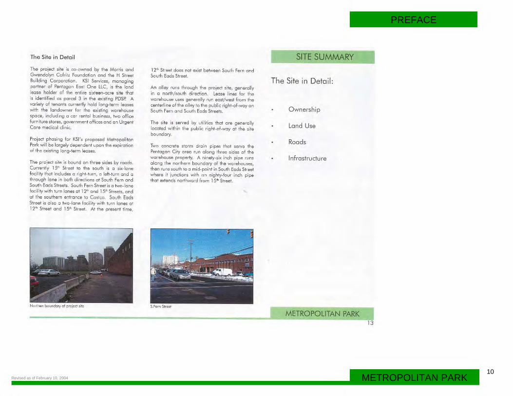
The project site is co-owned by the Morris ond Gwendolyn Cafritz Foundation and the H Street Building Corporation. KSI Services, managing partner of Pentagon East One LLC, is the land lease holder of the entire sixteen-acre site that is identified os parcel 3 in the existing PDSP. A variety of tenants currently hold long-term leoses with the landowner for the existing warehouse space, including o car rental business, two office furniture stores, government offices and an Urgent Care medical clinic.
Project phasing for KSl's proposed Metropolitan Park will be largely dependent upon the expiration of the existing long-term leases.
The project site is bound on three sides by roads. Currently 15'' Street to the south is a six-lone facility that includes a right-turn, o left-turn and a through lane in both directions at South Fe rn and South Eads Streets. South Fern Street is a two-lane foci lily with turn lanes al 12'' and 15"' Streets, and at the southern entrance to Costco. South Eads Street is a lso a two-lane facility with turn lanes at 12" Street and 15"' Street. At the present time,
Northen boundary of projed site
12'' Street does not exist between South Fern and South Eads Street.
An alley runs through the project site, generally in a north/south direction. Lease lines for the warehouse uses generally run east/west from the centerline of the alley to the public right-of-way on South Fern and South Eads Streets.
The site is served by utilities that are generally located within the public right-of-way al the site boundary.
Two concrete storm drain pipes that serve the Pentagon City areo run along three sides of the wa rehouse property. A ninety-six inch pipe runs along the northern bounda ry of the warehouses, then runs south too mid-point in South Eads Street where it junctions with on eighty-four inch pipe that extends northward from 15" Street.
S. Fern Street
SITE SUMMARY
The Site in Detail :
Ownership
Land Use
Roads
Infrastructure
METROPOLITAN PARK 13
11 Revised as of February 10, 2004
D EXISTING BUILDINGS
El BUILDING HEIGHT (STORIES)
~ - ~ PROJECT AREA . - . 14.
Master Plan In Context: Scale 1"=400'
I Existing Commerciol
I (Potential Retail Edge)
L
Existing Residentio I
~
l
Vocont
(Potential Retoil Edge)
I
... ·~· ...... . .
--
---. ----I .. .. : ... \. ....
\ l
Existing Residential
Planning Analysis, Scale l " = 400'
Existing Residential
• ~ Vehicle Connectivity • RETAIL
• • • Pedestrian Connectivity
The diogrom shows potential connectivity to the existing rood ond pedestrian systems
PREFACE
12METROPOLITAN PARKRevised as of February 10, 2004
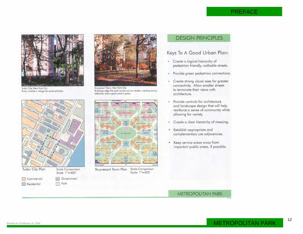
Tudor City, New York City Parks provide a refuge for quiet activities.
Tudor City Plan
0 Commercial
0 Residential
Scale Comparison Scale 1"=400'
0 Government
O Park
Stuyvesant Town, New York City Buildings edge the park across narrow streets, creating strong definition and a great cenh'ol green.
-pe. .. "~"· ,:.:c "
Stuyvesant Town Plan
-
Scale Comparison Scale 1 "=400'
DESIGN PRINCIPLES
Keys To A Good Urban Plan:
Create a logical hierarchy of pedestrian friendly, walkable streets.
Provide green pedestrian connections.
Create strong visual axes for greater connectivity. Allow smaller streets to terminate their views with architecture.
Provide controls for architecture and landscape design that will help reinforce a sense of community while allowing for variety.
Create a clear hierarchy of massing.
Establish appropriate and complementary use adjacencies.
Keep service areas away from important public areas, if possible.
METROPOLITAN PARK
13
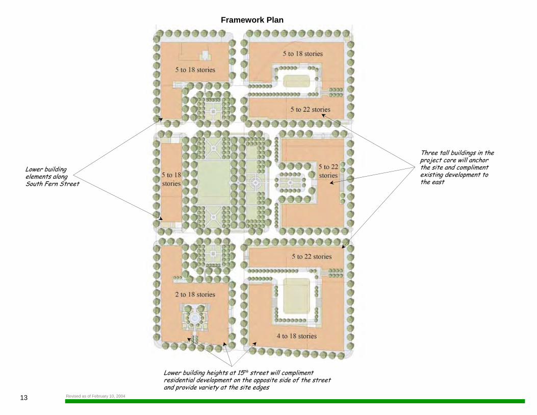
Framework Plan
Lower building elements along South Fern Street
Three tall buildings in theproject core will anchor the site and compliment existing development to the east
Lower building heights at 15th street will complimentresidential development on the opposite side of the streetand provide variety at the site edges
Revised as of February 10, 2004
FRAMEWORK PLAN
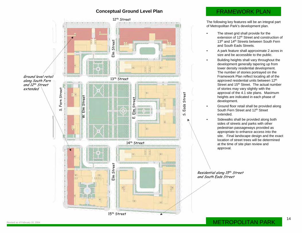
• The street grid shall provide for the extension of 12th Street and construction of 13th and 14th Streets between South Fern and South Eads Streets.
• A park feature shall approximate 2 acres in size and be accessible to the public.
• Building heights shall vary throughout the development generally tapering up from lower density residential development. The number of stories portrayed on the Framework Plan reflect locating all of the approved residential units between 12th
Street and 15th Street. The actual number of stories may vary slightly with the approval of the 4.1 site plans. Maximum heights are indicated in each phase of development.
• Ground floor retail shall be provided along South Fern Street and 12th Street extended.
• Sidewalks shall be provided along both sides of streets and parks with other pedestrian passageways provided as appropriate to enhance access into the site. Final landscape design and the exact location of street trees will be determined at the time of site plan review and approval.
Conceptual Ground Level Plan
Ground level retailalong South Fernand 12th Streetextended
Residential along 15th Street and South Eads Street
The following key features will be an integral part of Metropolitan Park’s development plan.
14METROPOLITAN PARK
15th Street
14th Street
13th Street
12th Street
Elm
Str
e et
Elm
Str
e et
S. F
e rn
Str e
et
S. E
a ds
Str e
e t
E. E
l m S
t re e
t
W. E
lm S
tre e
t
Revised as of February 10, 2004
P
PP
P
P
PP
PP
15
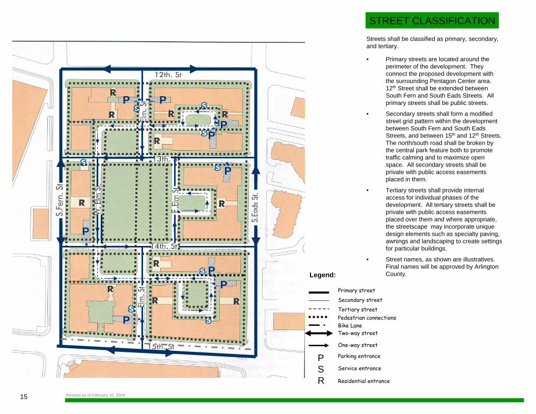
STREET CLASSIFICATION
• Primary streets are located around the perimeter of the development. They connect the proposed development with the surrounding Pentagon Center area. 12th Street shall be extended between South Fern and South Eads Streets. All primary streets shall be public streets.
• Secondary streets shall form a modified street grid pattern within the development between South Fern and South Eads Streets, and between 15th and 12th Streets. The north/south road shall be broken by the central park feature both to promote traffic calming and to maximize open space. All secondary streets shall be private with public access easements placed in them.
• Tertiary streets shall provide internal access for individual phases of the development. All tertiary streets shall be private with public access easements placed over them and where appropriate, the streetscape may incorporate unique design elements such as specialty paving, awnings and landscaping to create settings for particular buildings.
• Street names, as shown are illustratives. Final names will be approved by Arlington County.
Streets shall be classified as primary, secondary, and tertiary.
Legend:
Primary street
Secondary streetTertiary streetPedestrian connectionsBike LaneTwo-way street
One-way street
Parking entrance
Service entrance
Residential entrance
PSR
Revised as of February 10, 2004
16METROPOLITAN PARK
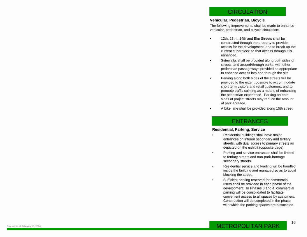
CIRCULATION
• 12th, 13th , 14th and Elm Streets shall be constructed through the property to provide access for the development, and to break up the current superblock so that access through it is enhanced.
• Sidewalks shall be provided along both sides of streets, and around/through parks, with other pedestrian passageways provided as appropriate to enhance access into and through the site.
• Parking along both sides of the streets will be provided to the extent possible to accommodate short term visitors and retail customers, and to promote traffic calming as a means of enhancing the pedestrian experience. Parking on both sides of project streets may reduce the amount of park acreage.
• A bike lane shall be provided along 15th street.
Residential, Parking, Service• Residential buildings shall have major
entrances on interior secondary and tertiary streets, with dual access to primary streets as depicted on the exhibit (opposite page).
• Parking and service entrances shall be limited to tertiary streets and non-park-frontage secondary streets.
• Residential service and loading will be handled inside the building and managed so as to avoid blocking the street.
• Sufficient parking reserved for commercial users shall be provided in each phase of the development. In Phases 3 and 4, commercial parking will be consolidated to facilitate convenient access to all spaces by customers. Construction will be completed in the phase with which the parking spaces are associated.
ENTRANCES
Vehicular, Pedestrian, BicycleThe following improvements shall be made to enhance vehicular, pedestrian, and bicycle circulation:
Revised as of February 10, 2004
17
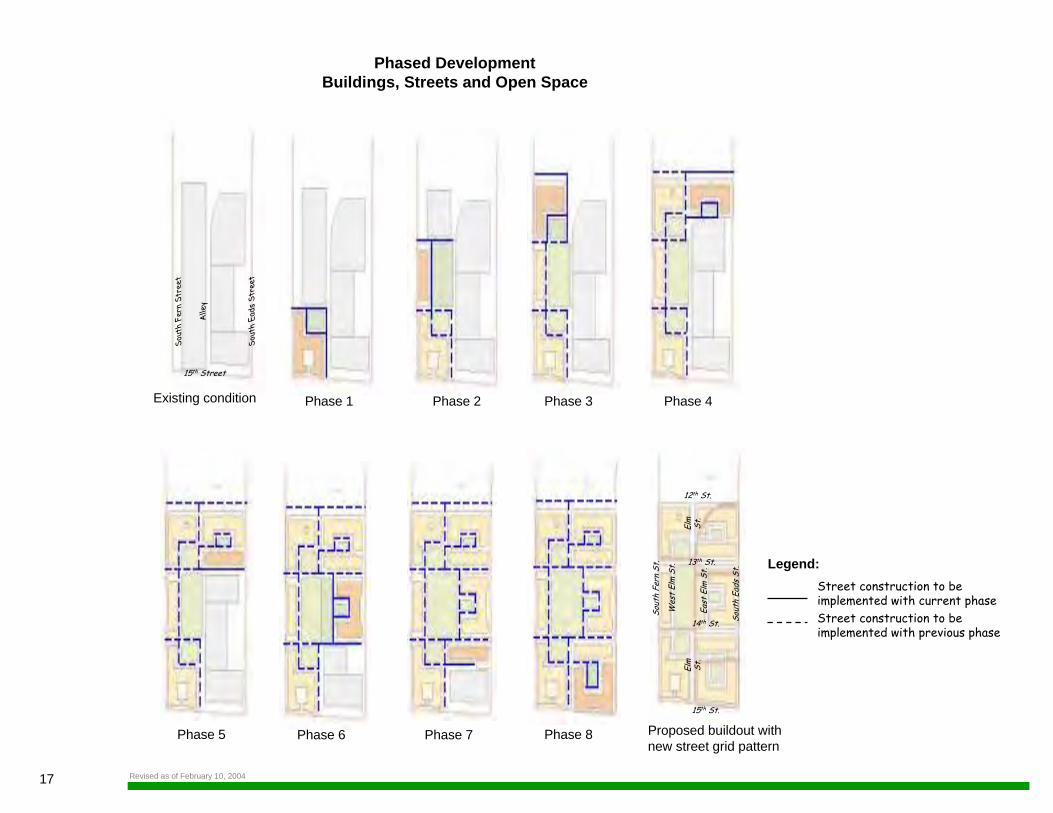
Phased DevelopmentBuildings, Streets and Open Space
Legend:Street construction to be implemented with current phaseStreet construction to be implemented with previous phase
Sout
h Fe
rn S
tree
t
Alle
y
Sout
h Ea
ds S
tree
t
15th Street
Existing condition Phase 1 Phase 2 Phase 3 Phase 4
Phase 5 Phase 6 Phase 7 Phase 8 Proposed buildout with new street grid pattern
12th St.
13th St.
14th St.
15th St.
Sout
h Fe
rn S
t.
Wes
t El
m S
t.
East
Elm
St.
Elm
St
.El
m
St.
Sout
h Ea
ds S
t.
Revised as of February 10, 2004
18METROPOLITAN PARK
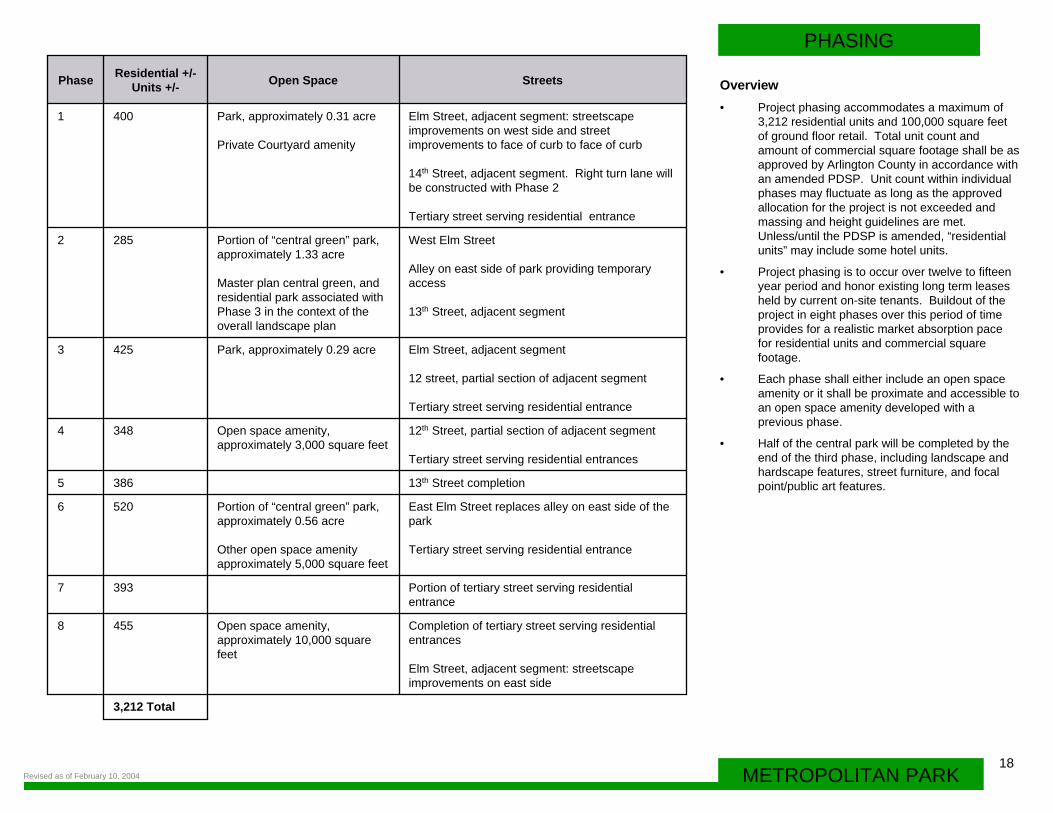
PHASING
Overview• Project phasing accommodates a maximum of
3,212 residential units and 100,000 square feet of ground floor retail. Total unit count and amount of commercial square footage shall be as approved by Arlington County in accordance with an amended PDSP. Unit count within individual phases may fluctuate as long as the approved allocation for the project is not exceeded and massing and height guidelines are met. Unless/until the PDSP is amended, “residential units” may include some hotel units.
• Project phasing is to occur over twelve to fifteen year period and honor existing long term leases held by current on-site tenants. Buildout of the project in eight phases over this period of time provides for a realistic market absorption pace for residential units and commercial square footage.
• Each phase shall either include an open space amenity or it shall be proximate and accessible to an open space amenity developed with a previous phase.
• Half of the central park will be completed by the end of the third phase, including landscape andhardscape features, street furniture, and focal point/public art features.
3,212 Total
Completion of tertiary street serving residential entrances
Elm Street, adjacent segment: streetscape improvements on east side
Open space amenity, approximately 10,000 square feet
4558
Portion of tertiary street serving residential entrance
3937
East Elm Street replaces alley on east side of the park
Tertiary street serving residential entrance
Portion of “central green” park, approximately 0.56 acre
Other open space amenity approximately 5,000 square feet
5206
13th Street completion 3865
12th Street, partial section of adjacent segment
Tertiary street serving residential entrances
Open space amenity, approximately 3,000 square feet
3484
Elm Street, adjacent segment
12 street, partial section of adjacent segment
Tertiary street serving residential entrance
Park, approximately 0.29 acre 4253
West Elm Street
Alley on east side of park providing temporary access
13th Street, adjacent segment
Portion of “central green” park, approximately 1.33 acre
Master plan central green, and residential park associated with Phase 3 in the context of the overall landscape plan
2852
Elm Street, adjacent segment: streetscape improvements on west side and street improvements to face of curb to face of curb
14th Street, adjacent segment. Right turn lane will be constructed with Phase 2
Tertiary street serving residential entrance
Park, approximately 0.31 acre
Private Courtyard amenity
4001
StreetsOpen SpaceResidential +/-Units +/-Phase
Revised as of February 10, 2004
19
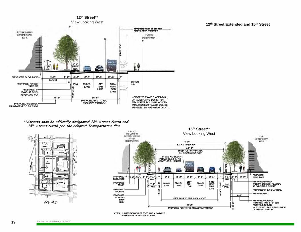
12th Street Extended and 15th Street
Key Map
12th Street**View Looking West
**Streets shall be officially designated 12th Street South and 15th Street South per the adopted Transportation Plan.
15th Street**View Looking West
Revised as of February 10, 2004
20METROPOLITAN PARK
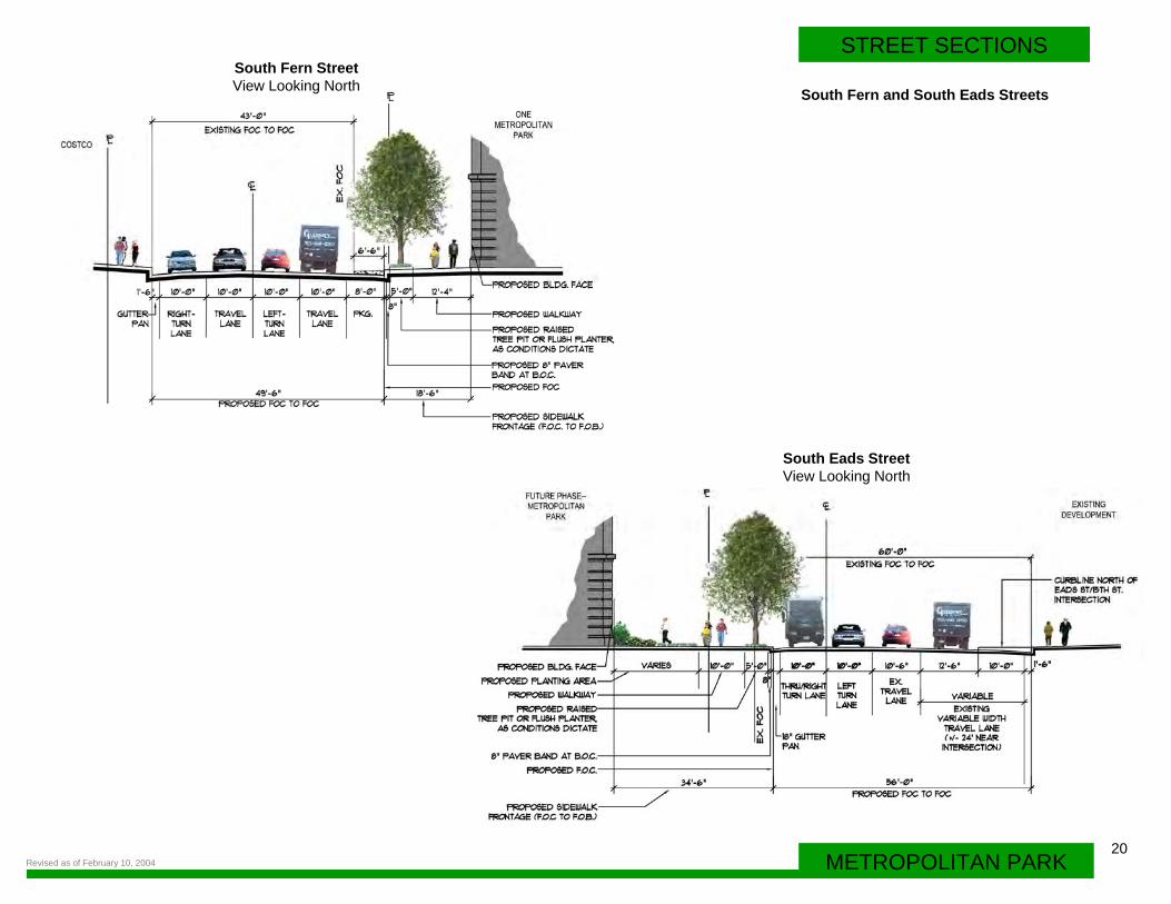
STREET SECTIONS
South Fern and South Eads Streets
South Eads StreetView Looking North
South Fern StreetView Looking North
Revised as of February 10, 2004
21
Key Map
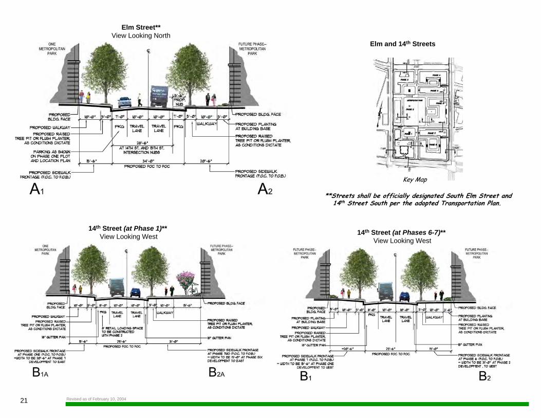
Elm and 14th Streets
14th Street (at Phase 1)** View Looking West 14th Street (at Phases 6-7)**
View Looking West
**Streets shall be officially designated South Elm Street and14th Street South per the adopted Transportation Plan.
Elm Street**View Looking North
Revised as of February 10, 2004
22METROPOLITAN PARK
STREET SECTIONS
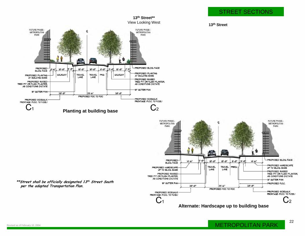
13th Street
13th Street**View Looking West
**Street shall be officially designated 13th Street Southper the adopted Transportation Plan.
Planting at building base
Alternate: Hardscape up to building base
Revised as of February 10, 2004
23
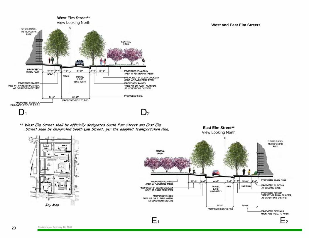
West and East Elm Streets
Key Map
West Elm Street**View Looking North
East Elm Street**View Looking North
** West Elm Street shall be officially designated South Fair Street and East Elm Street shall be designated South Elm Street, per the adopted Transportation Plan.
Revised as of February 10, 2004
24METROPOLITAN PARK
STREET SECTIONS
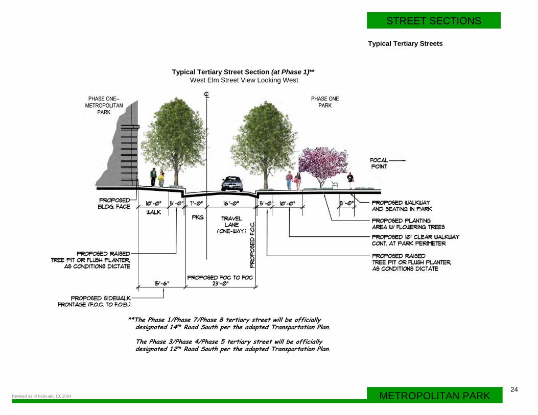
Typical Tertiary Streets
Typical Tertiary Street Section (at Phase 1)** West Elm Street View Looking West
**The Phase 1/Phase 7/Phase 8 tertiary street will be officiallydesignated 14th Road South per the adopted Transportation Plan.
The Phase 3/Phase 4/Phase 5 tertiary street will be officially designated 12th Road South per the adopted Transportation Plan.
Revised as of February 10, 2004
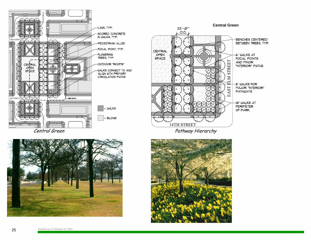
Pathway Hierarchy
25
Central Green
Central Green
Revised as of February 10, 2004
26METROPOLITAN PARK
OPEN SPACE
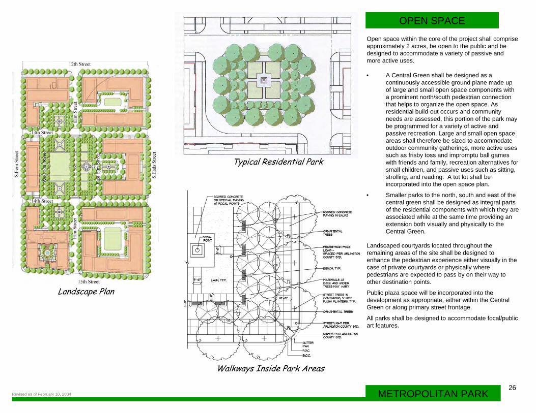
• A Central Green shall be designed as a continuously accessible ground plane made up of large and small open space components with a prominent north/south pedestrian connection that helps to organize the open space. As residential build-out occurs and community needs are assessed, this portion of the park may be programmed for a variety of active and passive recreation. Large and small open space areas shall therefore be sized to accommodate outdoor community gatherings, more active uses such as frisby toss and impromptu ball games with friends and family, recreation alternatives for small children, and passive uses such as sitting, strolling, and reading. A tot lot shall be incorporated into the open space plan.
• Smaller parks to the north, south and east of the central green shall be designed as integral parts of the residential components with which they are associated while at the same time providing an extension both visually and physically to the Central Green.
Open space within the core of the project shall comprise approximately 2 acres, be open to the public and be designed to accommodate a variety of passive and more active uses.
Landscaped courtyards located throughout the remaining areas of the site shall be designed to enhance the pedestrian experience either visually in the case of private courtyards or physically where pedestrians are expected to pass by on their way to other destination points.
Public plaza space will be incorporated into the development as appropriate, either within the Central Green or along primary street frontage.
All parks shall be designed to accommodate focal/public art features.
Typical Residential Park
Walkways Inside Park Areas
Landscape Plan
Revised as of February 10, 2004
27 Revised as of February 10, 2004
PROPOSED 12th SfREET
u u u u . -u u u
orouu11
'I
II I I•
II I I• ~
D [ ~
~
11 I l 15th STREET
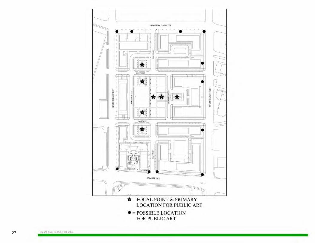
* =FOCAL POINT & PRIMARY LOCATION FOR PUBLIC ART
• = POSSIBLE LOCATION FOR PUBLIC ART
[ [t ~
28METROPOLITAN PARK
PUBLIC ART
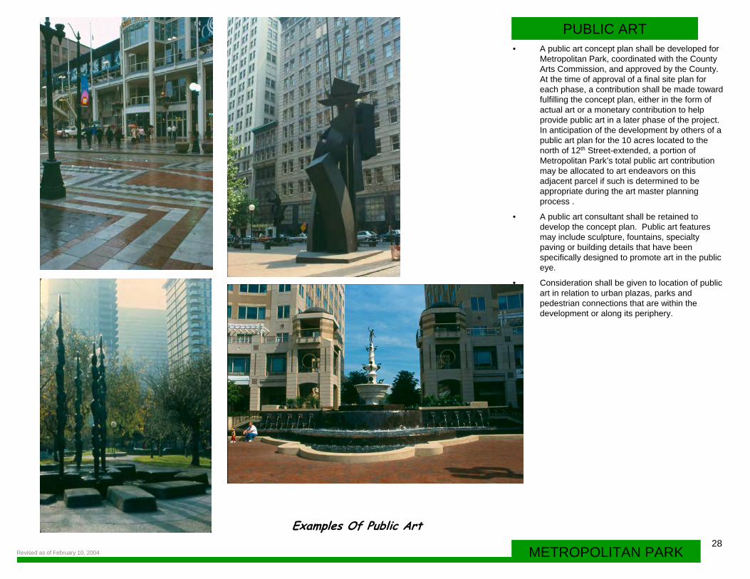
Examples Of Public Art
• A public art concept plan shall be developed for Metropolitan Park, coordinated with the County Arts Commission, and approved by the County. At the time of approval of a final site plan for each phase, a contribution shall be made toward fulfilling the concept plan, either in the form of actual art or a monetary contribution to help provide public art in a later phase of the project. In anticipation of the development by others of a public art plan for the 10 acres located to the north of 12th Street-extended, a portion of Metropolitan Park’s total public art contribution may be allocated to art endeavors on this adjacent parcel if such is determined to be appropriate during the art master planning process .
• A public art consultant shall be retained to develop the concept plan. Public art features may include sculpture, fountains, specialty paving or building details that have been specifically designed to promote art in the public eye.
• Consideration shall be given to location of public art in relation to urban plazas, parks and pedestrian connections that are within the development or along its periphery.
Revised as of February 10, 2004
29
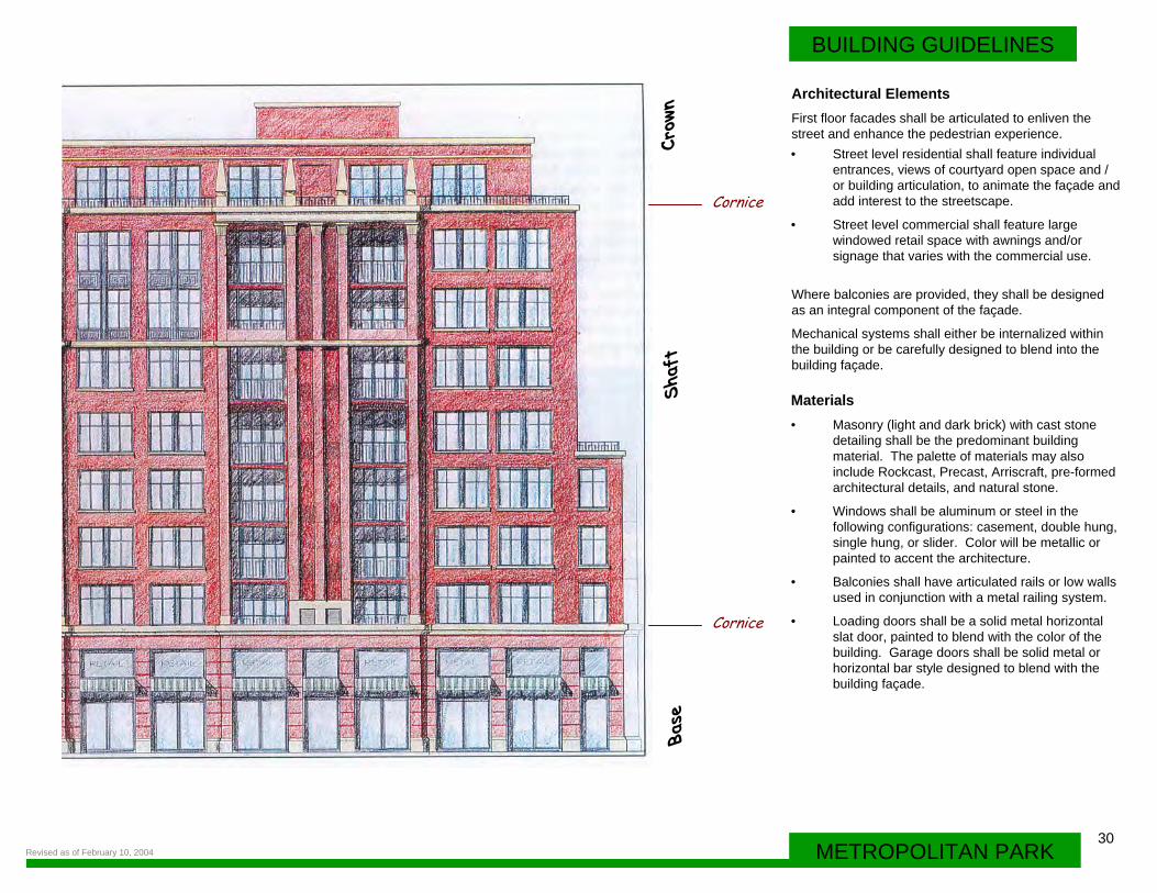
• The building base shall relate to the adjacent street and sidewalk and be scaled to enhance the pedestrian experience. The base may be characterized by light-colored masonry materials with a darker water-table and an articulated façade for first floor residential uses, and the addition of windowed facades for ground floor retail uses. Cornices may be used to differentiate the building base from the shaft. First floor height shall be a minimum of 18 feet .
• The shaft may be designed as a darker field with lighter accents so as to reinforce vertical and horizontal rhythms of the architecture and break the scale of the building.
• The building crown shall define the building at the skyline and shall incorporate as appropriate architectural elements to create a memorable image.
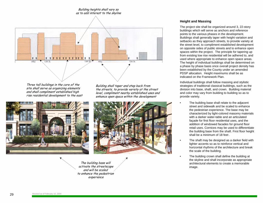
Height and MassingThe project site shall be organized around 3, 22-story buildings which will serve as anchors and reference points to the various phases in the development. Buildings shall generally taper with height variation and setbacks as they approach streets, to provide variety at the street level, to compliment established development on opposite sides of public streets and to enhance open spaces within the project. The principle for tapering up from existing low rise residential will be adhered to, and used where appropriate to enhance open space areas. The height of individual buildings shall be determined on a phase by phase basis once overall project density has been established by the County under an amended PDSP allocation. Height maximums shall be as indicated on the Framework Plan.
Individual buildings shall follow massing and stylistic strategies of traditional classical buildings, such as the division into base, shaft, and crown. Building material and color may vary from building to building so as to provide variety.
Building heights shall vary soas to add interest to the skyline
Building shall taper and step back from the streets, to provide variety at the streetlevel, compliment nearby established uses and enhance open space within the development
Three tall buildings in the core of thesite shall serve as organizing elements and shall compliment established high rise residential development to the east
The building base will activate the streetscape
and will be scaled to enhance the pedestrian
experience
Revised as of February 10, 2004
30METROPOLITAN PARK
BUILDING GUIDELINES
• Street level residential shall feature individual entrances, views of courtyard open space and / or building articulation, to animate the façade and add interest to the streetscape.
• Street level commercial shall feature large windowed retail space with awnings and/or signage that varies with the commercial use.
Architectural ElementsFirst floor facades shall be articulated to enliven the street and enhance the pedestrian experience.
Where balconies are provided, they shall be designed as an integral component of the façade.
Mechanical systems shall either be internalized within the building or be carefully designed to blend into the building façade.
Materials • Masonry (light and dark brick) with cast stone
detailing shall be the predominant building material. The palette of materials may also include Rockcast, Precast, Arriscraft, pre-formed architectural details, and natural stone.
• Windows shall be aluminum or steel in the following configurations: casement, double hung, single hung, or slider. Color will be metallic or painted to accent the architecture.
• Balconies shall have articulated rails or low walls used in conjunction with a metal railing system.
• Loading doors shall be a solid metal horizontal slat door, painted to blend with the color of the building. Garage doors shall be solid metal or horizontal bar style designed to blend with the building façade.
Base
Shaf
tCr
own
Cornice
Cornice
Revised as of February 10, 2004
31
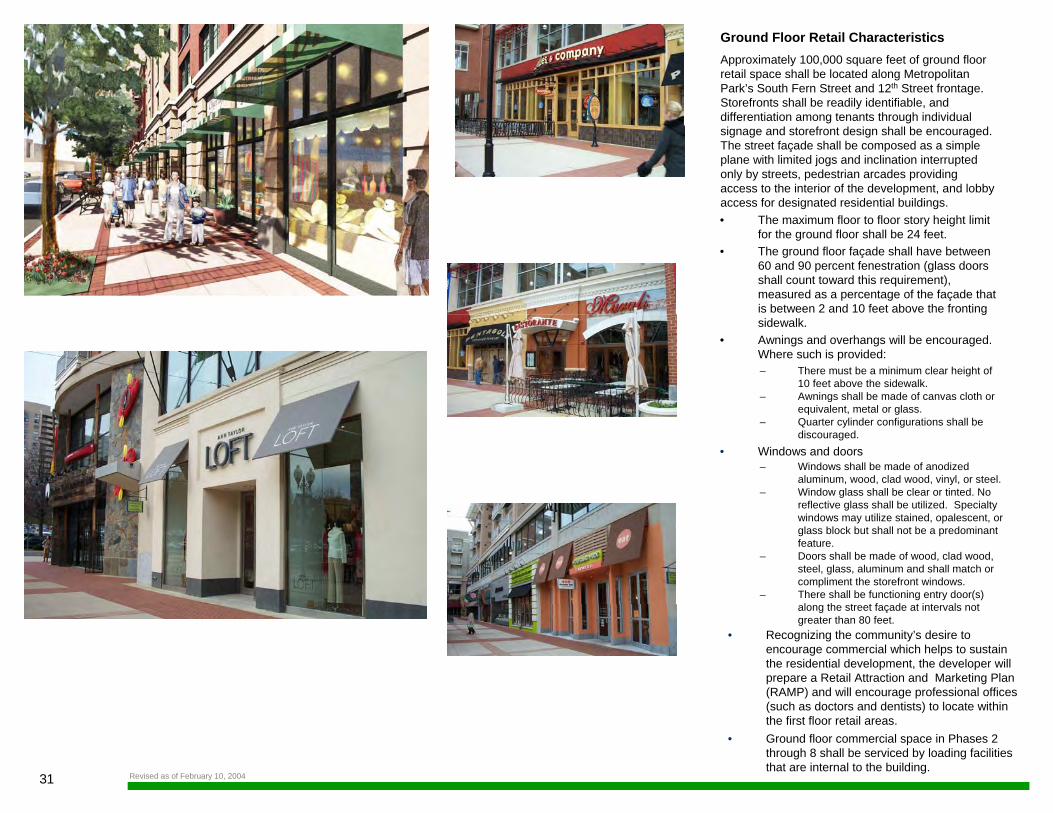
Ground Floor Retail Characteristics Approximately 100,000 square feet of ground floor retail space shall be located along Metropolitan Park’s South Fern Street and 12th Street frontage. Storefronts shall be readily identifiable, and differentiation among tenants through individual signage and storefront design shall be encouraged. The street façade shall be composed as a simple plane with limited jogs and inclination interrupted only by streets, pedestrian arcades providing access to the interior of the development, and lobby access for designated residential buildings.• The maximum floor to floor story height limit
for the ground floor shall be 24 feet.• The ground floor façade shall have between
60 and 90 percent fenestration (glass doors shall count toward this requirement), measured as a percentage of the façade that is between 2 and 10 feet above the fronting sidewalk.
• Awnings and overhangs will be encouraged. Where such is provided: – There must be a minimum clear height of
10 feet above the sidewalk.– Awnings shall be made of canvas cloth or
equivalent, metal or glass.– Quarter cylinder configurations shall be
discouraged. • Windows and doors
– Windows shall be made of anodized aluminum, wood, clad wood, vinyl, or steel.
– Window glass shall be clear or tinted. No reflective glass shall be utilized. Specialty windows may utilize stained, opalescent, or glass block but shall not be a predominant feature.
– Doors shall be made of wood, clad wood, steel, glass, aluminum and shall match or compliment the storefront windows.
– There shall be functioning entry door(s) along the street façade at intervals not greater than 80 feet.
• Recognizing the community’s desire to encourage commercial which helps to sustain the residential development, the developer will prepare a Retail Attraction and Marketing Plan (RAMP) and will encourage professional offices (such as doctors and dentists) to locate within the first floor retail areas.
• Ground floor commercial space in Phases 2 through 8 shall be serviced by loading facilities that are internal to the building.
Revised as of February 10, 2004
32METROPOLITAN PARK
BUILDING GUIDELINES
• Wall signs will be permitted within an area between the second story floor line and the first floor ceiling, within a horizontal band not to exceed three feet in height. In no case shall this band be higher than 20 feet or lower than 12 feet above the adjacent sidewalk.
• Letters shall not exceed 24 inches in height or width and 8 inches in relief.
• Company logos or names may be placed within the horizontal band noted above, or placed or painted within ground floor windows. Company logos or names shall not be larger than 9 square feet.
• Street addresses shall be placed at street entry doors using 6 inch tall non-cursive type lettering that no less than 6” tall, unless otherwise determined by County requirements.
• Shop signs (not more than 18 inches vertical by 3 feet horizontal with a minimum of 9 foot clear height above the sidewalk) may be wall mounted or hung from an overhang or awning.
• If lettering is applied to an awning, it shall be limited to the vertically hanging fabric on the curb side of the awning.
• Awning shall not have internal illumination.
• Prohibited signs shall include billboards, marquees, any kind of animation, roof and painted window signs (other than company logos), flat plexiglas box signs, and signs painted on the exterior walls of buildings. No flashing, traveling, animated, or intermittent lighting shall be on the exterior of any building whether such lighting is of temporary or long-term duration. Temporary “sandwich board” type signage shall be permitted as long as a minimum clear sidewalk width of 8 feet exists.
SignageIndividual signs for residential buildings will be approved with each 4.1 site plan application. A temporary wayfinding sign package shall be developed and shall remain in place until all secondary streets have been completed. Signage for the commercial portion of the development shall comply with the following guidelines:
Revised as of February 10, 2004
33 Revised as of February 10, 2004
8 11 PAVER--____, BAND CONT.
AT B.O.C.
~~""'----+/- 4'x4' SCORED CONCRETE PAVING
IL---STREET TREES SPACED FER ARLINGTON COUNTY S TDS.
PAVER 6AND5 AT B.O.W. AND ALIGNED WITH TREE PITS
1---.---1--++-.,,..__-s• X 12' TREE P IT W/ 6 11 CURB SURROUND
8 11 PAVER·---• L BAND CONT.
Al 6.0.C.
+/ - 4'x4' SCORED CONCRElE PAVING
IL--STREET TREES SPACED FER ARLINGTON COUNTY S TDS.
PAVER BANDS AT 6 .0.W. AND ALIGNED WITH TREE P ITS
H::::::±==:~--S TREET R.IRNITURE
,.,.- --CONDITIONS AT 1----.M_._4-__ •- --CONDITIONS AT STREETL IGHT--·----U:~11------"~-L B.O.W. VARY STREETLIGHT--·----ll:t:x"'I 6 .0.W. VARY
SPACED PER SPACED PER ARLINGTON COUNTY ARLINGTON COUNTY
STD. STD.
l 10'-0 11 l ~ 1
CONDITION l--TREES IN RAISED TREE F ITS WITH 10' CLEAR WALKWAY BETWEEN BACK OF PIT AND BACK OF WALK
l 10'-011 ~ 1 1
CONDITION 2--TREES IN GRATES WITl-I 10' CLEAR WALKWAY BETWEEN BACK OF PIT AND BACK OF WALK
34METROPOLITAN PARK
LANDSCAPE GUIDELINES
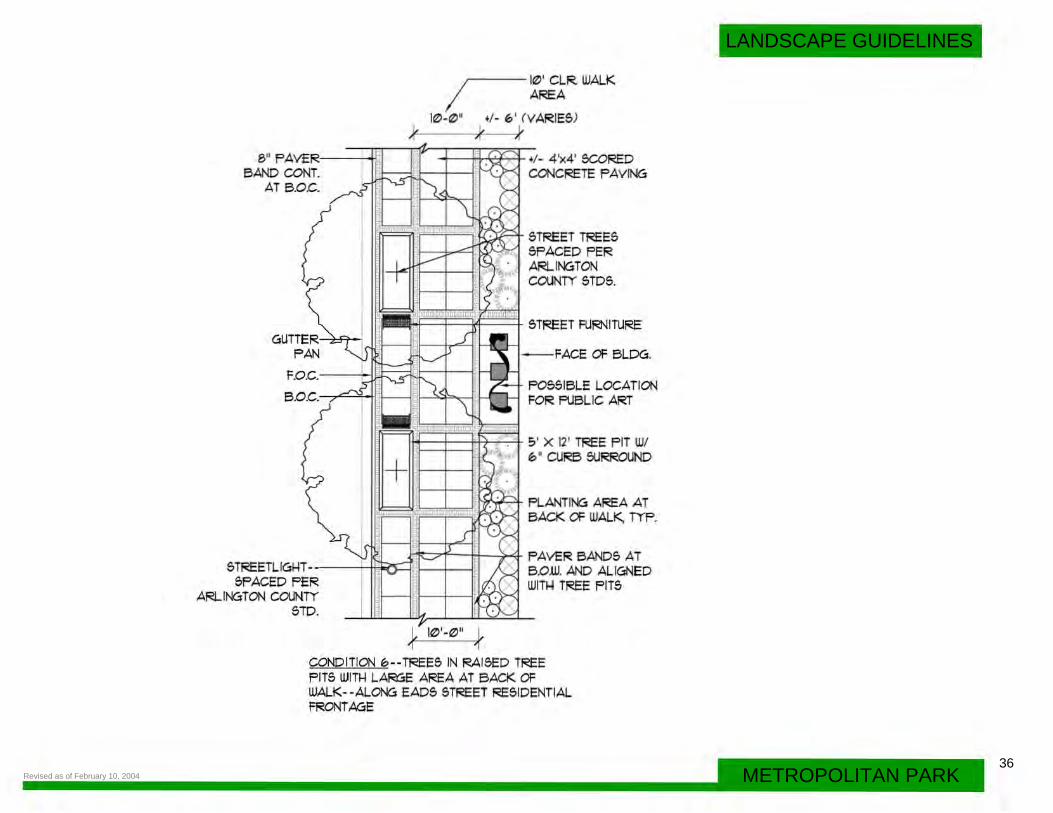
Streetscape Feature Streetscapes shall be designed to provide a safe means of pedestrian circulation, easy access to buildings and amenities within the development and linkages to the greater Pentagon City community. Streetscape conditions may vary, adding to the pedestrian experience. However, consistency in sidewalk width, street tree species, tree pit details, and paving pattern details shall be maintained along individual streets.
• Street trees and ground plane planting shall be provided between sidewalks and street curbs to soften the interface between pedestrians and vehicles.
• Buildings shall meet the sidewalk along retail facades.
• Planting areas may be provided at the base of residential buildings where individual unit entrances, stoops, etc. exist, so as to soften and enrich the streetscape and enhance the residential character of the street.
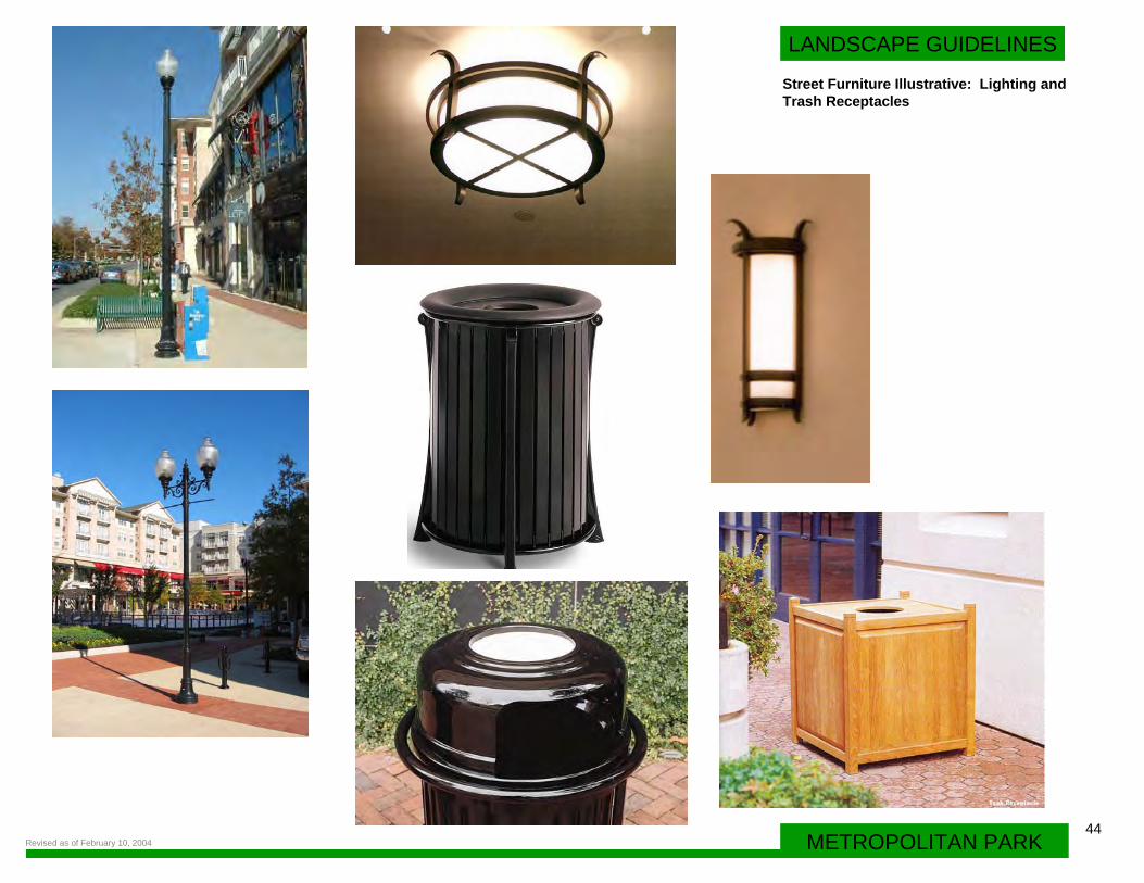
• Street furniture such as benches and trash receptacles shall be provided along streets and within parks. Street furniture design may vary within the development. Benches, lighting (per Arlington County standards) and trash receptacles provided along the retail edges of South Fern and 12th Streets may differ, for instance, from those provided along the more residential perimeter streets of 15th and South Eads Streets. Yet another street furniture package may be appropriate for park settings and building entrances situated along secondary and tertiary streets within Metropolitan Park. Consistency shall be maintained, however, along individual streets and within individual park components.
Revised as of February 10, 2004
35 Revised as of February 10, 2004
8 " PAVER--BAND CONT.
AT B.O.C.
STREETL IGHT-SPACED FER
ARLINGTON COUNTY STD.
--li-+----:;'-1' WIDE PEDESTRIAN FASS-Tl-IROU61-1S BETWEEN TREES, TYP.
-LI.b::dt-1-STREET TREES
SPACED PER ARLINGTON COUNTY STDS.
+/- 4'x4' SCORED CONCRETE PAVING OR PAVER FIELD
~'-+t-....:::::..-~-PAVER BANDS AT e.o.w. AND BACK OF PLANTING STRIPS
-++--+-+--r---CONTINUOUS &' WIDE
GUTTER----- "'"'--~-_.c..
PLANTING STRIP, OR 5 'Xl2' PLANTER F IT, OR 5 'X8' TREE GRATES.
FAN
F.O.C.---i1 -----CONDITIONS AT B.O.C.---1 B.O.W. VARY
~ ~ 1 b '-0'?1
CONDITION 4--6 ' CLEAR UJALKWAY BETUEEN BACK OF PLANTING AREA AND BACK OF WALK
R T.
8" PAVE BAND CON
AT B.O
I I
~-GUTT p AN ~
.c.
I F.O
6.0
,'
~
~ T-
R ON TD.
·TREETLIGl-I 5PACED PE
ARLINGT COUNTY 5
~-------l!Zl' CLR WALK AREA
k llZ>-IZ>" (, +/-12-1!;' !.. ~ K A
~
y ,,, ..
~ ;...l'J ... ------\ -~
~ I
I I ~~~
;:i
~ IUU i.m.·a m rn : rt. I1
_j ---...I'
lJ ..___
~ ~
"·~ ~~ \
,__
~---,__
I -5 -+ ) ..___
~ '---!= I' .._____ -
,___ J -.._~Ll ---v-- ..___
..___
~
I'
~FOS51BL E OJTD AREAD FART B
OOR RETAIL EFINED IN y
SPECIAL PAVING
STREET SPACED
TREE5 PER
ON 5TD5.
ARLINGT COUNTY
[>-FAVER AT F.0.6.
BAND5 AND WITl-I
T5 ALIGNED TREE Pl
STREET RJRNITU
FACE OF
:;• X 12' T PIT W/ 6 ' SURR
RE
BUILDING
REE ' CURB
OUND
+/ - 4 'x4' SCORED CONCRE TE PAVING
CONDITION 5--TREE5 IN RAl5ED TREE FIT5 WITl-I LARGE PAVING AREA AT 12Tl-I 5TREET RETAIL FRONTAGE
36METROPOLITAN PARK
LANDSCAPE GUIDELINES
Revised as of February 10, 2004
8 11 FAVER----+IOI BAND CONT.
AT B.O.C.
~ 1~' CLR. WALK I AREA
1~-~" +/ - 6 ' ( VARIES) (, ~
~--t-rT'7--+- +/ - 4 'x4' SCORED CONCRETE FAYING
STREET TREES SFACED FER ARLINGTON COUNTY STDS.
- FACE OF BLDG.
F05SIBLE LOCATION ~~~ ' - r--L-' FOR FUBLIC ART
,_..___,1---++-+---+ 5 ' X 12' TREE F IT W/
+ 6 II CURB SURROUND
~"'7'f'--~~4- FAVER BANDS AT S TREETLIGl4T ----Yl'~=--i B.O.W. AND ALIGNED
SFACED FER WITl-3 TREE F ITS ARLINGTON COUNTY
STD.
L 1~·-~11 ~ 1 'I
CONDITION 6--TREES IN RAISED TREE FITS WITH LARGE AREA AT BACK OF WALK- -ALONG EADS STREET RESIDENTIAL FRONTAGE
37
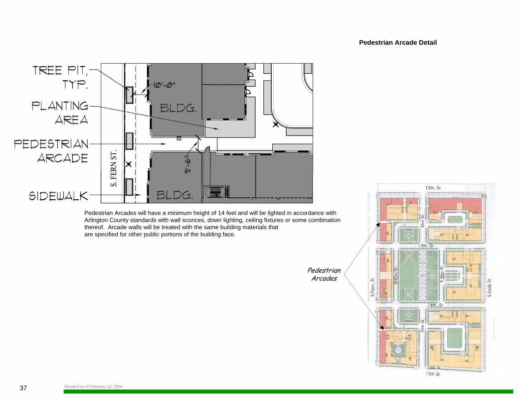
Pedestrian Arcade Detail
PedestrianArcades
Pedestrian Arcades will have a minimum height of 14 feet and will be lighted in accordance withArlington County standards with wall sconces, down lighting, ceiling fixtures or some combination thereof. Arcade walls will be treated with the same building materials that are specified for other public portions of the building face.
Revised as of February 10, 2004
38METROPOLITAN PARK
LANDSCAPE GUIDELINES
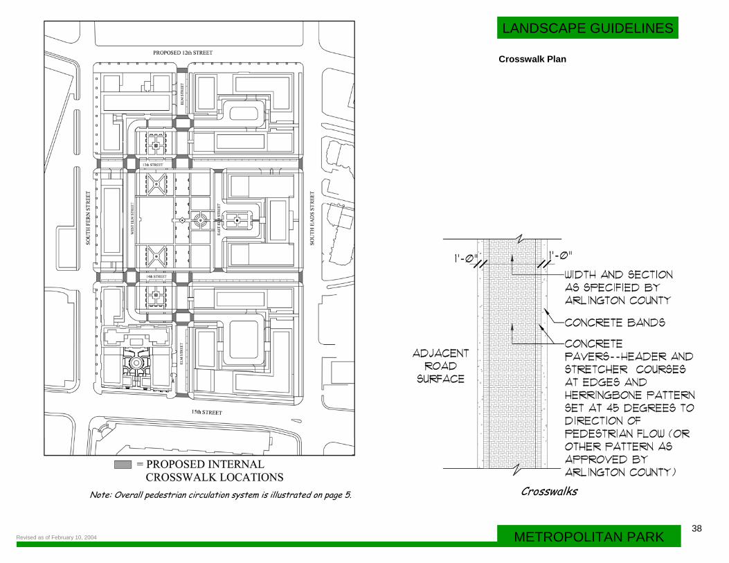
Crosswalk Plan
Note: Overall pedestrian circulation system is illustrated on page 5. Crosswalks
Revised as of February 10, 2004
39 Revised as of February 10, 2004
FAC.E OF C.URe
Q I
8 "
S'-0"
SEC.Tl ON: TYPIC.AL STREET TREE PLANTIN6
AD..JAC.ENT PAVIN<Si
PLANTIN<Si SOIL
DRAINA6E MATERIAL AND DRAINPIPE Q
I
r---ADJAC.ENT
SEC.Tl ON: TYPIC.AL TREE PLANTIN6
OVER STRUC. TURE
SURFAC.E VARIES
PLANTIN6 SOIL
DRAINA6E MATERIAL
STRUC.TURAL SLAB
40METROPOLITAN PARK
LANDSCAPE GUIDELINES
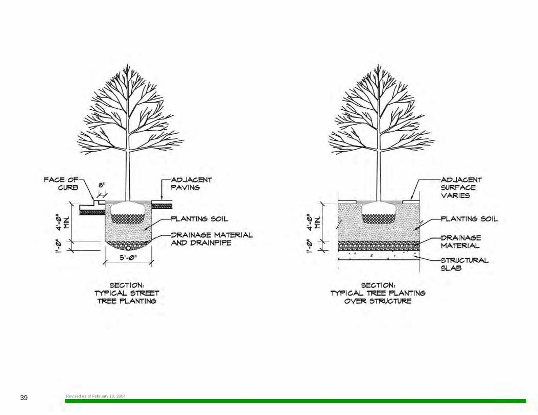
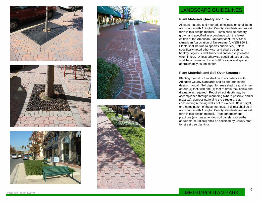
Plant Materials Quality and SizeAll plant material and methods of installation shall be in accordance with Arlington County standards and as set forth in this design manual. Plants shall be nursery-grown and specified in accordance with the latest edition of the American Standard for Nursery Stock (American Association of Nurserymen), ANSI Z60.1. Plants shall be true to species and variety, unless specifically noted otherwise, and shall be sound, healthy, vigorous, well branched and densely foliated when in leaf. Unless otherwise specified, street trees shall be a minimum of 4 to 4-1/2” caliper and spaced approximately 30’ on center.
Plant Materials and Soil Over StructurePlanting over structure shall be in accordance with Arlington County standards and as set forth in this design manual. Soil depth for trees shall be a minimum of four (4) feet, with one (1) foot of drain rock below and drainage as required. Required soil depth may be accomplished through mounding (where possible and/or practical), depressing/folding the structural slab, constructing retaining walls not to exceed 30” in height, or a combination of these methods. Soil mix shall be in accordance with Arlington County standards and as set forth in this design manual. Root enhancement practices (such as amended soil panels, root paths and/or structural soil) shall be specified by County staff for street tree plantings.
Revised as of February 10, 2004
41 Revised as of February 10, 2004
LANDSCAPE GUIDELINES
42METROPOLITAN PARK
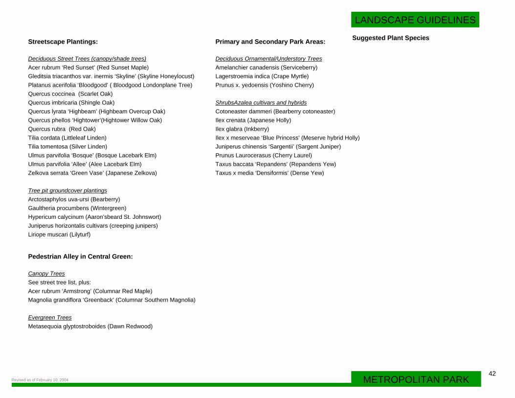
Streetscape Plantings:
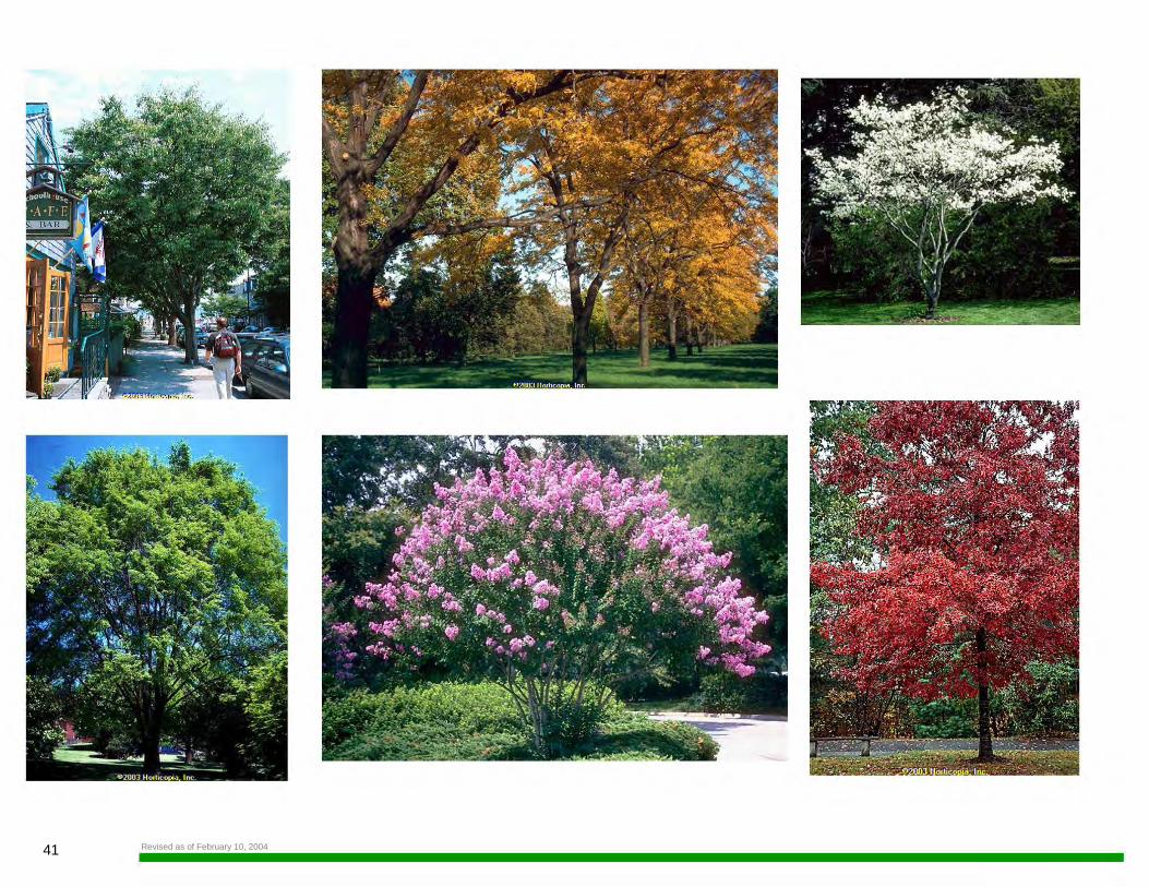
Deciduous Street Trees (canopy/shade trees)Acer rubrum ‘Red Sunset’ (Red Sunset Maple)Gleditsia triacanthos var. inermis ‘Skyline’ (Skyline Honeylocust)Platanus acerifolia ‘Bloodgood’ ( Bloodgood Londonplane Tree)Quercus coccinea (Scarlet Oak)Quercus imbricaria (Shingle Oak)Quercus lyrata ‘Highbeam’ (Highbeam Overcup Oak)Quercus phellos ‘Hightower’(Hightower Willow Oak)Quercus rubra (Red Oak)Tilia cordata (Littleleaf Linden)Tilia tomentosa (Silver Linden)Ulmus parvifolia ‘Bosque’ (Bosque Lacebark Elm)Ulmus parvifolia ‘Allee’ (Alee Lacebark Elm)Zelkova serrata ‘Green Vase’ (Japanese Zelkova)
Tree pit groundcover plantingsArctostaphylos uva-ursi (Bearberry)Gaultheria procumbens (Wintergreen)Hypericum calycinum (Aaron’sbeard St. Johnswort)Juniperus horizontalis cultivars (creeping junipers)Liriope muscari (Lilyturf)
Primary and Secondary Park Areas:
Deciduous Ornamental/Understory TreesAmelanchier canadensis (Serviceberry)Lagerstroemia indica (Crape Myrtle)Prunus x. yedoensis (Yoshino Cherry)
ShrubsAzalea cultivars and hybridsCotoneaster dammeri (Bearberry cotoneaster)Ilex crenata (Japanese Holly)Ilex glabra (Inkberry)Ilex x meserveae ‘Blue Princess’ (Meserve hybrid Holly)Juniperus chinensis ‘Sargentii’ (Sargent Juniper)Prunus Laurocerasus (Cherry Laurel)Taxus baccata ‘Repandens’ (Repandens Yew)Taxus x media ‘Densiformis’ (Dense Yew)
Pedestrian Alley in Central Green:
Canopy Trees See street tree list, plus:Acer rubrum ‘Armstrong’ (Columnar Red Maple)Magnolia grandiflora ‘Greenback’ (Columnar Southern Magnolia)
Evergreen TreesMetasequoia glyptostroboides (Dawn Redwood)
Suggested Plant Species
Revised as of February 10, 2004
43
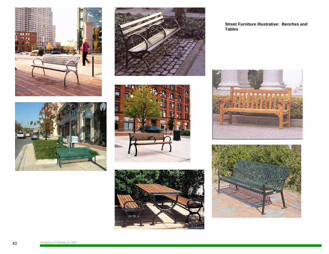
Street Furniture Illustrative: Benches and Tables
Revised as of February 10, 2004
LANDSCAPE GUIDELINES
Street Furniture Illustrative: Lighting and Trash Receptacles
44METROPOLITAN PARKRevised as of February 10, 2004