Embed Size (px)
Citation preview
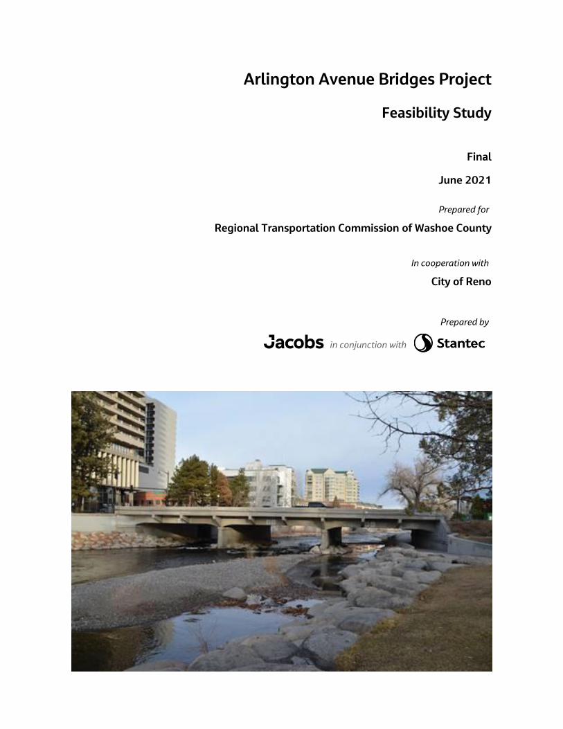
Arlington Avenue Bridges Project
Feasibility Study
Final
June 2021
Prepared for
Regional Transportation Commission of Washoe County
In cooperation with
City of Reno
Prepared by
in conjunction with

Arlington Bridges Feasibility Study
Final Report-June 2021 i
Contents
Acronyms and Abbreviations .......................................................................................................................................... v
1. Introduction and Study Background .......................................................................................................... 1-1
1.1 Purpose and Need ......................................................................................................................................... 1-2
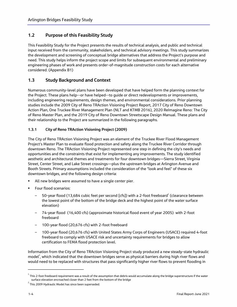
1.2 Purpose of this Feasibility Study .............................................................................................................. 1-4
1.3 Study Background and Context ................................................................................................................ 1-4
1.3.1 City of Reno TRAction Visioning Project (2009) ............................................................... 1-4
1.3.2 City of Reno Downtown Action Plan (2017) ....................................................................... 1-5
1.3.3 One Truckee River Management Plan (2016) ................................................................... 1-7
1.3.4 ReImagine Reno: The City of Reno Master Plan (2020) ................................................ 1-7
1.3.5 City of Reno Downtown Streetscape Design Manual (2019)....................................... 1-8
1.4 Planning and Environmental Linkages ............................................................................................... 1-10
2. Corridor Conditions ........................................................................................................................................ 2-1
2.1 Structural Condition ...................................................................................................................................... 2-1
2.2 Traffic .................................................................................................................................................................. 2-2
2.3 Pedestrian, Bicycle, and Transist Uses ................................................................................................... 2-2
2.4 Environmental Resources ........................................................................................................................... 2-4
2.4.1 River Hydraulics ............................................................................................................................. 2-4
2.4.2 Historic/Prehistoric Resources ................................................................................................. 2-5
2.4.3 Section 4(f) and 6(f) Resources ............................................................................................... 2-5
2.4.4 Wildlife and Aquatic Resources ............................................................................................... 2-6
2.4.5 Wetlands and Waters of the United States .......................................................................... 2-6
2.4.6 Land Use ........................................................................................................................................... 2-7
2.4.6 Hazardous Materials ..................................................................................................................... 2-7
3. Alternatives Development and Screening Process ................................................................................ 3-1
3.1 Level 1 Qualitative Screening Analysis .................................................................................................. 3-3
3.2 Level 2 Quantitative Screening Analysis: .............................................................................................. 3-4
3.2.1 Single Pier ........................................................................................................................................ 3-4
3.2.2 Clear Span ........................................................................................................................................ 3-5
3.3 Roadway and Pedestrian Concepts ......................................................................................................... 3-6
3.3.1 Additional Path Under South Bridge ..................................................................................... 3-6
3.4 Constructability Review ............................................................................................................................... 3-6
3.5 Cost Estimate ................................................................................................................................................... 3-7
3.6 Local, State, and Federal Funding ........................................................................................................... 3-9
3.6.1 Local and State Funding ............................................................................................................. 3-9
3.6.2 Federal Funding ............................................................................................................................. 3-9
4. Potential Impacts ........................................................................................................................................... 4-1
4.1 Traffic .................................................................................................................................................................. 4-1
4.2 Environmental Resources ........................................................................................................................... 4-1
4.3 Environmental Permits Required ............................................................................................................. 4-2
Arlington Bridges Feasibility Study
ii Final Report-June 2021
5. Outreach Conducted for this Study ............................................................................................................ 5-1
5.1 Overview ............................................................................................................................................................ 5-1
5.2 Key Findings ..................................................................................................................................................... 5-1
6. Next Steps ........................................................................................................................................................ 6-1
6.1 Key Actions for Next Phase ........................................................................................................................ 6-2
6.2 Anticipated National Environmental Policy Act Process ................................................................ 6-2
7. References ........................................................................................................................................................ 7-1
Appendixes
A Planning and Environmental Linkages Checklist B Technical Memoranda
B1 Purpose and Need
B2 Traffic Resources
B3 Bicycle, Pedestrian and Transiti Uses
B4 Hyology and Hydraulics Resources
B5 Culture Resources
B6 Section 4(f) and Sectoin 6(f)
B7 Biological and Aquatic Resources
B8 Land Use
B9 Hazardous Materials C Bridge Alternatives D Cost Estimates E Technical Advisory Committee, Stakeholder Working Group, and Public Meeting Summaries
E1 Public Meeting #1
E2 SWG -1 Meeting
E3 TAC-1 Meeting
E4 TAC-2 Meeting
E5 SWG - 2 Meeting
E6 SWG - 3 Meeting
E7 Public Meeting #2 Postcard Flyer, Presentation, Presentation Script, Survey Respones, FAQs,
and Public & Agency Comments
E8 Miscellaneous Comments F Aesthetics Design
G Wingfield Park Improvements Process and Timeline
Tables
1 Bridge B-1531 Conditions (South Arlington Avenue Bridge) ....................................................................... 2-1 2 Bridge B-1532 Conditions (North Arlington Avenue Bridge) ....................................................................... 2-2 3 Bridge Concept Crosswalk ........................................................................................................................................... 3-2 4 Level 1 Qualitative Screening Analysis Results .................................................................................................. 3-3 5 Order of Magnitude Project Cost Ranges .............................................................................................................. 3-8 6 Revenue Projections identified in the RTC 2040 Regional Transportation Plan ............................... 3-10 7 Stakeholder Workshop Involvement and Agreements .................................................................................... 5-1 8 Summary of Public Meeting #1 Comments ......................................................................................................... 5-3
Arlington Bridges Feasibility Study
Final Report-June 2021 iii
Figures
1 Project Location............................................................................................................................................................... 1-1 2 North Bridge (Number B1532), Spalling and Exposed Rebar ...................................................................... 1-2 3 Market Assessment Study Area ................................................................................................................................. 1-6 4 Downtown Streetscape Design Standards Map ............................................................................................... 1-10 5 Levels of Service .............................................................................................................................................................. 2-3 6a Permit Determination Process – Flowchart 1 ...................................................................................................... 4-3
6b Permit Determination Process – Flowchart 2 ...................................................................................................... 4-3 6c Permit Determination Process – Flowchart 3 ...................................................................................................... 4-3 6d Permit Determination Process – Flowchart 4 ...................................................................................................... 4-3 6e Permit Determination Process – Flowchart 5 ...................................................................................................... 4-3 7a Project Development Schedule ................................................................................................................................ 6-1
7b Project Development Accelerated Schedule ....................................................................................................... 6-1

Arlington Bridges Feasibility Study
Final Report-June 2021 v
Acronyms and Abbreviations
BUILD Better Utilizing Investments to Leverage Development
cfs cubic feet per second
CIP cast-in-place
CLOMR Conditional Letter of Map
CS-N1 Clear Span Concept: Underdeck Arch
CS-N2 Clear Span Concept: Rigid Frame
CS-N3 Clear Span Concept: Tied Arch
CTWCD Carson-Truckee Water Conservancy District
CWA Clean Water Act
EB-NS1 Elevated Bridge Concept: Precast Concrete Girders
EB-NS2 Elevated Bridge Concept: Cast-in-Place Concrete Box
EB-NS3 Elevated Bridge Concept: Steel I-Girders
FEMA Federal Emergency Management Agency
FHWA Federal Highway Administration
FY Fiscal Year
HEC-RAS Hydrologic Engineering Center (HEC) in Davis, California, developed River Analysis
System (RAS) to aid hydraulic engineers in channel flow analysis and floodplain
determination.
KTMB Keep Truckee Meadows Beautiful
LOS level of service
LWCF Land and Water Conservation Funds
MBTA Migratory Bird Treaty Act
NDEP Nevada Division of Environmental Protection
NDOT Nevada Department of Transportation
NDSL Nevada Division of State Lands
NEPA National Environmental Policy Act of 1969
NHPA National Historic Preservation Act of 1966
NLT Nevada Land Trust
NOFO Notice of Funding Opportunity
NRHP National Register of Historic Places
PEL Planning and Environmental Linkages
Project Arlington Avenue Bridges Project
RTC Regional Transportation Commission of Washoe County
Arlington Bridges Feasibility Study
vi Final Report-June 2021
RTP Regional Transportation Plan
SP-N1 Single Pier Concept: Precast Concrete Girders
SP-N2 Single Pier Concept: Cast-in-Place Concrete Box
SP-N3 Single Pier Concept: Steel I-Girders
SWG Stakeholder Working Group
TAC Technical Advisory Committee
TRFMA Truckee River Flood Management Authority
USACE United States Army Corps of Engineers
USDOT United States Department of Transportation
USFWS United States Fish and Wildlife Service
USGS United States Geological Survey
Arlington Bridges Feasibility Study
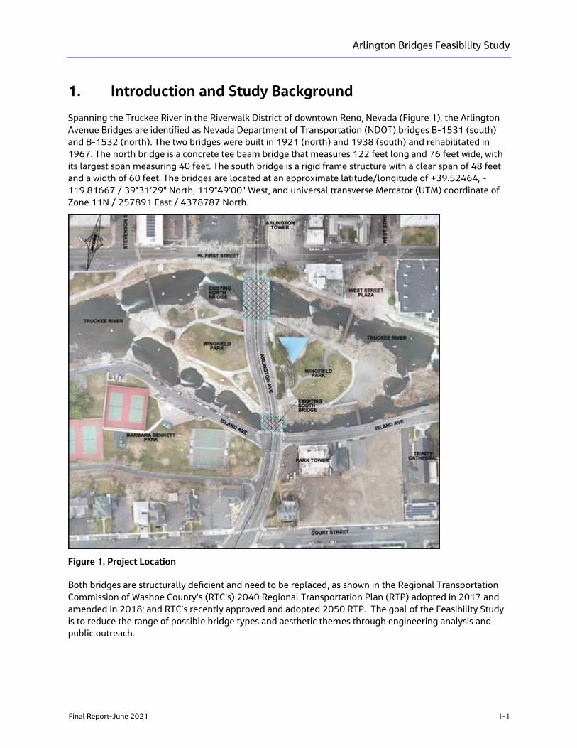
Final Report-June 2021 1-1
1. Introduction and Study Background
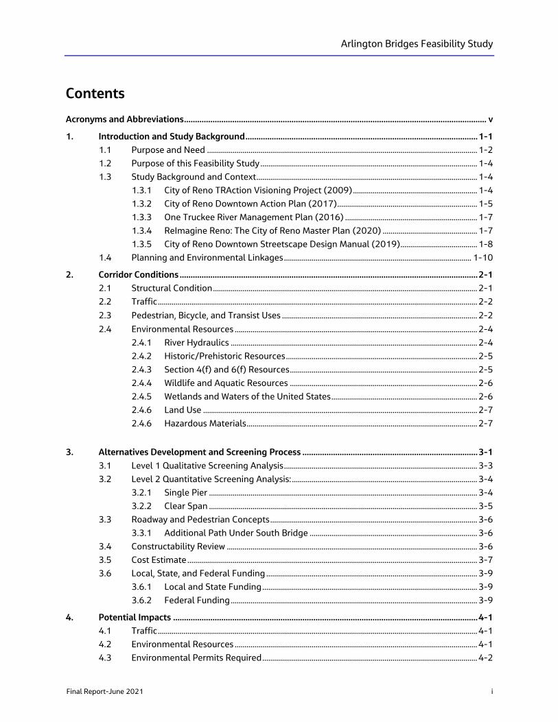
Spanning the Truckee River in the Riverwalk District of downtown Reno, Nevada (Figure 1), the Arlington
Avenue Bridges are identified as Nevada Department of Transportation (NDOT) bridges B-1531 (south)
and B-1532 (north). The two bridges were built in 1921 (north) and 1938 (south) and rehabilitated in
1967. The north bridge is a concrete tee beam bridge that measures 122 feet long and 76 feet wide, with
its largest span measuring 40 feet. The south bridge is a rigid frame structure with a clear span of 48 feet
and a width of 60 feet. The bridges are located at an approximate latitude/longitude of +39.52464, -
119.81667 / 39°31’29" North, 119°49’00" West, and universal transverse Mercator (UTM) coordinate of
Zone 11N / 257891 East / 4378787 North.
Figure 1. Project Location
Both bridges are structurally deficient and need to be replaced, as shown in the Regional Transportation
Commission of Washoe County’s (RTC’s) 2040 Regional Transportation Plan (RTP) adopted in 2017 and
amended in 2018; and RTC’s recently approved and adopted 2050 RTP. The goal of the Feasibility Study
is to reduce the range of possible bridge types and aesthetic themes through engineering analysis and
public outreach.
Arlington Bridges Feasibility Study
1-2 Final Report-June 2021
1.1 Purpose and Need
The purpose and need statement describes the intention of the Arlington Avenue Bridges Project (Project)
and states the problems the Project will address. Ultimately, it sets the stage for developing and
evaluating possible improvement alternatives but is not mode-specific or biased toward a particular
solution. Additional factors considered in evaluating potential alternatives must include input from
resource agencies, local governments, and the public; cost; and impacts to the human and natural
environment. A purpose and need statement is used in Planning and Environmental Linkages (PEL) and
National Environmental Policy Act of 1969 (NEPA) studies to articulate and focus on the specific problems
to be addressed.
The purpose of the Project is to address the deteriorating condition of the bridge structures, provide
community access to the Truckee River and Wingfield Park, and improve the hydraulic capacity of the
Truckee River during flood events.
Existing transportation needs for the Project include the following:
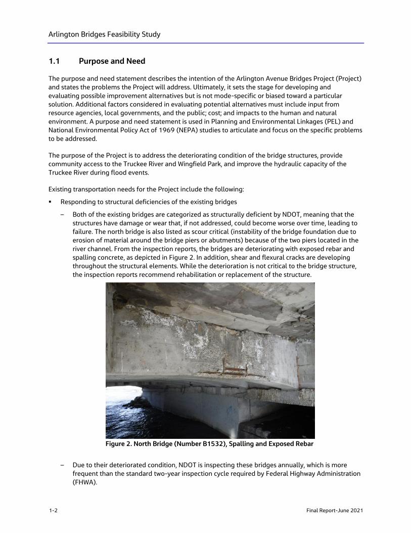
▪ Responding to structural deficiencies of the existing bridges
– Both of the existing bridges are categorized as structurally deficient by NDOT, meaning that the
structures have damage or wear that, if not addressed, could become worse over time, leading to
failure. The north bridge is also listed as scour critical (instability of the bridge foundation due to
erosion of material around the bridge piers or abutments) because of the two piers located in the
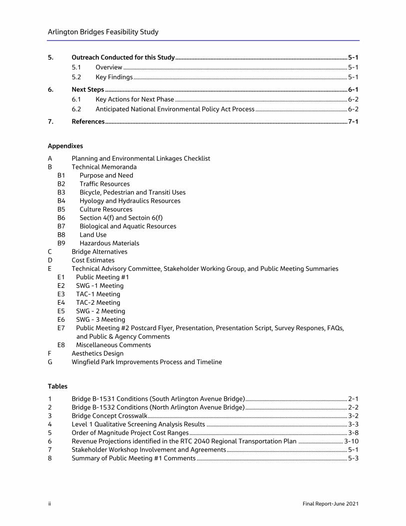
river channel. From the inspection reports, the bridges are deteriorating with exposed rebar and
spalling concrete, as depicted in Figure 2. In addition, shear and flexural cracks are developing
throughout the structural elements. While the deterioration is not critical to the bridge structure,
the inspection reports recommend rehabilitation or replacement of the structure.
Figure 2. North Bridge (Number B1532), Spalling and Exposed Rebar
– Due to their deteriorated condition, NDOT is inspecting these bridges annually, which is more
frequent than the standard two-year inspection cycle required by Federal Highway Administration
(FHWA).
Arlington Bridges Feasibility Study
Final Report-June 2021 1-3
▪ Improving pedestrian, bicycle, transit, and traffic safety in the area of Wingfield Park
– Wingfield Park is a high pedestrian and multi-modal user area. However, much of the existing
bicycle and pedestrian infrastructure on and adjacent to the bridges is not compliant with the
Americans with Disabilities Act of 1990 (ADA). There are mid-block crosswalks as well as transit
stops located in the park between the two bridges. These locations either lack lighting or are no
longer compliant with current lighting codes.
– The existing railing on the edge bridges overlooking the river is sub-standard.
– A review of the crash data indicates that, over the past five years, one non-serious crash involving
a pedestrian and a motor vehicle, and one non-serious crash involving a bicycle occurred in the
project area.
▪ Providing sufficient hydraulic capacity of the Truckee River during flood events
– Following the floods of 1997 and 2005, additional analysis has occurred to the bridges across the
Truckee River in Downtown Reno. Some of this analysis was completed as a part of the TRAction
Visioning Project Report (City of Reno 2009). New modeling completed by the Truckee River
Flood Management Authority and the Carson Truckee Water Conservancy District have better
defined the water surface elevation during flood events. There has been a focus to reduce the
number of features that restrict or impede the flow of water. Typical features that can impede
flows can include bridges, piers, walls, slopes, and debris. The existing north bridge has two piers
located in the river channel requiring the City of Reno maintenance staff to remove the debris
during flood events to ensure water passes below the bridge and in the channel. The removal of
debris is done from above with maintenance equipment parked on the bridge deck. The existing
south bridge is a clear span bridge.
▪ Respond to regional and community plans
– Several projects in the area and along the Truckee River have resulted in a patchwork of
improvements that create a disjointed and inconsistent network of amenities. The City of Reno has
approved the Downtown Action Plan (2017) and is reviewing and finalizing general design criteria
and specifications for downtown streetscapes aimed at providing a framework for consistent
downtown improvement strategies. Arlington Avenue is within these downtown plan areas and
does not currently conform to some of the proposed strategies.
– The TRAction Report called for the replacement of the existing Arlington Avenue Bridges because
they did not meet the flood design criteria used as part of that report. The report called for the
installation of a single 450-foot long bridge spanning the park, but it also noted that this concept
would result in significant vehicular and pedestrian access changes to the park.
– The City of Reno has completed an update to the city’s Master Plan called ReImagine Reno
(2020). The bridges and Wingfield Park are located within the Riverwalk District and along the
Truckee River Greenway Corridor. Greenway corridors are intended to protect the natural features
of the area and allow pedestrians, bicyclists, and other recreational users to access a variety of
public spaces. The master plan identifies the Truckee River as the most important greenway
corridor in the city and calls for design elements to accommodate access along the river for
community events and festivals throughout the year.
– The Truckee River Flood Management Authority, whose goal is to create a more flood-resilient
community, has developed a project plan aimed at reducing damage resulting from floods. One of
the components of the Flood Management Authority’s Plan is called the “Downtown Reach.’’”
Several individual projects have been identified for the Downtown Reach that are related to the
protection of the bridges and the replacement or construction of floodwalls upstream and
downstream of the project area.
Arlington Bridges Feasibility Study
1-4 Final Report-June 2021
1.2 Purpose of this Feasibility Study
This Feasibility Study for the Project presents the results of technical analysis, and public and technical
input received from the community, stakeholders, and technical advisory meetings. This study summarizes
the development and screening of conceptual bridge alternatives that address the Project’s purpose and
need. This study helps inform the project scope and limits for subsequent environmental and preliminary
engineering phases of work and presents order-of-magnitude construction costs for each alternative
considered. (Appendix B1)
1.3 Study Background and Context
Numerous community-level plans have been developed that have helped form the planning context for
the Project. These plans help--or have helped--to guide or direct redevelopments or improvements,
including engineering requirements, design themes, and environmental considerations. Prior planning
studies include the 2009 City of Reno TRAction Visioning Project Report, 2017 City of Reno Downtown
Action Plan, One Truckee River Management Plan (NLT and KTMB 2016), 2020 ReImagine Reno: The City
of Reno Master Plan, and the 2019 City of Reno Downtown Streetscape Design Manual. These plans and
their relationship to the Project are summarized in the following paragraphs.
1.3.1 City of Reno TRAction Visioning Project (2009)
The City of Reno TRAction Visioning Project was an element of the Truckee River Flood Management
Project’s Master Plan to evaluate flood protection and safety along the Truckee River Corridor through
downtown Reno. The TRAction Visioning Project represented one step in defining the city’s needs and
opportunities and the constraints that exist for implementing any improvements. The study identified
aesthetic and architectural themes and treatments for four downtown bridges—Sierra Street, Virginia
Street, Center Street, and Lake Street crossings—plus the upstream bridges at Arlington Avenue and
Booth Streets. Primary assumptions included the consideration of the “look and feel” of these six
downtown bridges, and the following design criteria:
▪ All new bridges were assumed to have a single center pier.
▪ Four flood scenarios:
– 50-year flood (13,684 cubic feet per second [cfs]) with a 2-foot freeboard1 (clearance between
the lowest point of the bottom of the bridge deck and the highest point of the water surface
elevation)
– 74-year flood (16,400 cfs) (approximate historical flood event of year 2005) with 2-foot
freeboard
– 100-year flood (20,676 cfs) with 2-foot freeboard
– 100-year flood (20,676 cfs) with United States Army Corps of Engineers (USACE) required 4-foot
freeboard to comply with USACE risk and uncertainty requirements for bridges to allow
certification to FEMA flood protection level.
Information from the City of Reno TRAction Visioning Project study produced a new steady-state hydraulic
model2, which indicated that the downtown bridges serve as physical barriers during high river flows and
would need to be replaced with structures that pass significantly higher river flows to prevent flooding in
1 This 2-foot freeboard requirement was a result of the assumption that debris would accumulate along the bridge superstructure if the water
surface elevation encroached closer than 2 feet from the bottom of the bridge 2 This 2009 Hydraulic Model has since been superseded.
Arlington Bridges Feasibility Study
Final Report-June 2021 1-5
the downtown area. Alternatives evaluated but eliminated during the study included upstream detention,
diversion channels, dredging, river widening, and debris fields. The study showed that even during the
lowest flood design (50-year flood design plus 2 feet of freeboard), water comes out of the channels and
floods the Wingfield Park island area between the Arlington Avenue Bridges created with the bifurcation of
the Truckee River. The study evaluated the following alternatives for the Arlington Avenue Bridges:
▪ Reconstruct at same locations to the current level of flood protection: This least costly alternative
would only replace the two existing bridges with a minimal amount of approach road reconstruction.
Both existing bridges are considered structurally deficient and eligible for replacement under the
Federal Highway Bridge Replacement and Rehabilitation Program. The bridges may require some
increase in elevation to keep flood waters within the channel. Some park areas continue to flood
during all four flood scenarios; this is a result of the lower elevation of some of the park island within
the river bifurcation compared to the outer bank elevations and the elevation of the Arlington Avenue
bridges and Arlington Avenue roadway through the middle of the park. The amphitheater is
approximately the same elevation as the roadway and isn’t impacted by flood waters.
▪ Reconstruct with one single bridge that extends between both riverbanks: This alternative includes
construction of a single 450-feet-long six-span bridge that crosses over both existing river channels
and the park. Pedestrians using the park would pass under the bridge. The bridge would be 82 feet
wide and include four lanes3 of traffic with a sidewalk on both sides.
The study concluded that bridge replacement would be required, underdeck bridge supports are
preferred, and reconstruction at their current location and elevation would not meet any flood design
criteria and was not considered an acceptable alternative. Reconstruction with a single bridge extending
between both banks was considered the acceptable alternative. Planning-level cost estimates4 included in
the study ranged from $19,000,000 to $21,250,000 (based on the square foot method) for the 74- and
100-year flood designs.
1.3.2 City of Reno Downtown Action Plan (2017)
The City of Reno Downtown Action Plan (Downtown Action Plan) identifies priorities for downtown
improvements to guide the City of Reno and the community for the next five to seven years. The plan is to
be used to advance community goals for the downtown area and addresses:
▪ Connectivity throughout downtown to the University of Nevada Reno and the Truckee River
▪ Pedestrian friendliness of downtown
▪ Creating a clean, safe, and vibrant downtown
▪ The excess of weekly motels with substandard living conditions as well as blighted properties
▪ Homeless and transient population
▪ Downtown property values
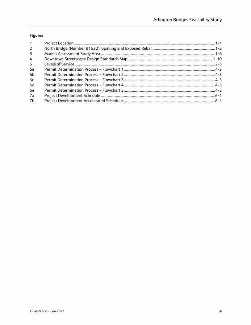
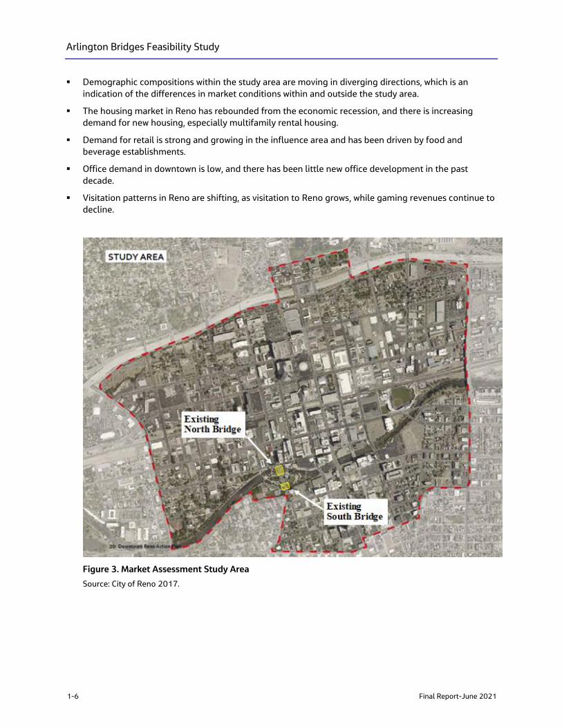
The Downtown Action Plan included a market assessment to evaluate the demand and feasibility of real
estate market activity downtown and identify order-of-magnitude opportunities and barriers related to
development. The assessment concluded that deteriorating conditions in downtown, along with other
factors, pushed demand for development to areas outside of the study area (Figure 3) and were
summarized as follows:
▪ Housing demand within central Reno is growing; however, the downtown study area has not yet
captured this demand.
3 This Study was completed prior to Arlington Avenue being restriped with only two lanes of traffic with dedicated bicycle lanes and left turn
lane. Arlington Avenue will not be changed back to a four-lane facility. 4 Cost Estimate represents year 2009 dollars and price market conditions
Arlington Bridges Feasibility Study
1-6 Final Report-June 2021
▪ Demographic compositions within the study area are moving in diverging directions, which is an
indication of the differences in market conditions within and outside the study area.
▪ The housing market in Reno has rebounded from the economic recession, and there is increasing
demand for new housing, especially multifamily rental housing.
▪ Demand for retail is strong and growing in the influence area and has been driven by food and
beverage establishments.
▪ Office demand in downtown is low, and there has been little new office development in the past
decade.
▪ Visitation patterns in Reno are shifting, as visitation to Reno grows, while gaming revenues continue to
decline.
Figure 3. Market Assessment Study Area
Source: City of Reno 2017.
Arlington Bridges Feasibility Study
Final Report-June 2021 1-7
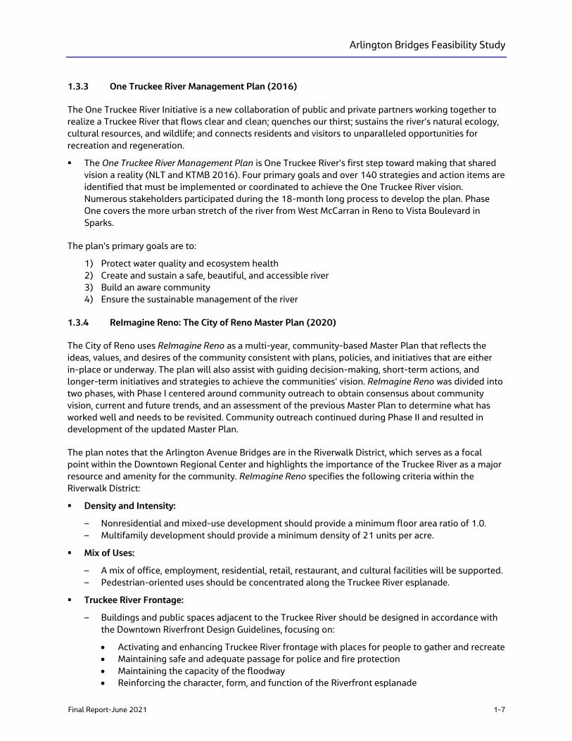
1.3.3 One Truckee River Management Plan (2016)
The One Truckee River Initiative is a new collaboration of public and private partners working together to
realize a Truckee River that flows clear and clean; quenches our thirst; sustains the river’s natural ecology,
cultural resources, and wildlife; and connects residents and visitors to unparalleled opportunities for
recreation and regeneration.
▪ The One Truckee River Management Plan is One Truckee River’s first step toward making that shared
vision a reality (NLT and KTMB 2016). Four primary goals and over 140 strategies and action items are
identified that must be implemented or coordinated to achieve the One Truckee River vision.
Numerous stakeholders participated during the 18-month long process to develop the plan. Phase
One covers the more urban stretch of the river from West McCarran in Reno to Vista Boulevard in
Sparks.
The plan’s primary goals are to:
1) Protect water quality and ecosystem health
2) Create and sustain a safe, beautiful, and accessible river
3) Build an aware community
4) Ensure the sustainable management of the river
1.3.4 ReImagine Reno: The City of Reno Master Plan (2020)
The City of Reno uses ReImagine Reno as a multi-year, community-based Master Plan that reflects the
ideas, values, and desires of the community consistent with plans, policies, and initiatives that are either
in-place or underway. The plan will also assist with guiding decision-making, short-term actions, and
longer-term initiatives and strategies to achieve the communities’ vision. ReImagine Reno was divided into
two phases, with Phase I centered around community outreach to obtain consensus about community
vision, current and future trends, and an assessment of the previous Master Plan to determine what has
worked well and needs to be revisited. Community outreach continued during Phase II and resulted in
development of the updated Master Plan.
The plan notes that the Arlington Avenue Bridges are in the Riverwalk District, which serves as a focal
point within the Downtown Regional Center and highlights the importance of the Truckee River as a major
resource and amenity for the community. ReImagine Reno specifies the following criteria within the
Riverwalk District:
▪ Density and Intensity:
– Nonresidential and mixed-use development should provide a minimum floor area ratio of 1.0.
– Multifamily development should provide a minimum density of 21 units per acre.
▪ Mix of Uses:
– A mix of office, employment, residential, retail, restaurant, and cultural facilities will be supported.
– Pedestrian-oriented uses should be concentrated along the Truckee River esplanade.
▪ Truckee River Frontage:
– Buildings and public spaces adjacent to the Truckee River should be designed in accordance with
the Downtown Riverfront Design Guidelines, focusing on:
• Activating and enhancing Truckee River frontage with places for people to gather and recreate
• Maintaining safe and adequate passage for police and fire protection
• Maintaining the capacity of the floodway
• Reinforcing the character, form, and function of the Riverfront esplanade
Arlington Bridges Feasibility Study
1-8 Final Report-June 2021
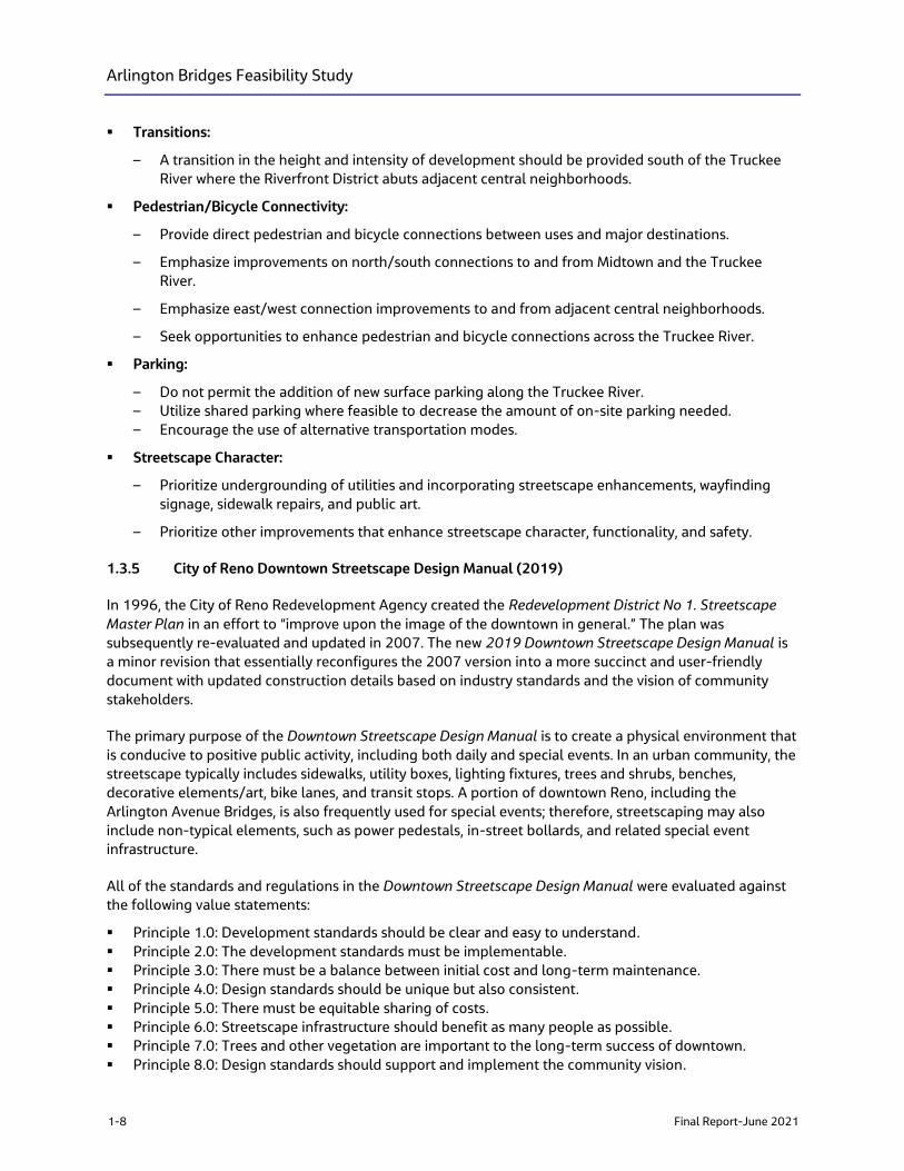
▪ Transitions:
– A transition in the height and intensity of development should be provided south of the Truckee
River where the Riverfront District abuts adjacent central neighborhoods.
▪ Pedestrian/Bicycle Connectivity:
– Provide direct pedestrian and bicycle connections between uses and major destinations.
– Emphasize improvements on north/south connections to and from Midtown and the Truckee
River.
– Emphasize east/west connection improvements to and from adjacent central neighborhoods.
– Seek opportunities to enhance pedestrian and bicycle connections across the Truckee River.
▪ Parking:
– Do not permit the addition of new surface parking along the Truckee River.
– Utilize shared parking where feasible to decrease the amount of on-site parking needed.
– Encourage the use of alternative transportation modes.
▪ Streetscape Character:
– Prioritize undergrounding of utilities and incorporating streetscape enhancements, wayfinding
signage, sidewalk repairs, and public art.
– Prioritize other improvements that enhance streetscape character, functionality, and safety.
1.3.5 City of Reno Downtown Streetscape Design Manual (2019)
In 1996, the City of Reno Redevelopment Agency created the Redevelopment District No 1. Streetscape
Master Plan in an effort to “improve upon the image of the downtown in general.” The plan was
subsequently re-evaluated and updated in 2007. The new 2019 Downtown Streetscape Design Manual is
a minor revision that essentially reconfigures the 2007 version into a more succinct and user-friendly
document with updated construction details based on industry standards and the vision of community
stakeholders.
The primary purpose of the Downtown Streetscape Design Manual is to create a physical environment that
is conducive to positive public activity, including both daily and special events. In an urban community, the
streetscape typically includes sidewalks, utility boxes, lighting fixtures, trees and shrubs, benches,
decorative elements/art, bike lanes, and transit stops. A portion of downtown Reno, including the
Arlington Avenue Bridges, is also frequently used for special events; therefore, streetscaping may also
include non-typical elements, such as power pedestals, in-street bollards, and related special event
infrastructure.
All of the standards and regulations in the Downtown Streetscape Design Manual were evaluated against
the following value statements:
▪ Principle 1.0: Development standards should be clear and easy to understand.
▪ Principle 2.0: The development standards must be implementable.
▪ Principle 3.0: There must be a balance between initial cost and long-term maintenance.
▪ Principle 4.0: Design standards should be unique but also consistent.
▪ Principle 5.0: There must be equitable sharing of costs.
▪ Principle 6.0: Streetscape infrastructure should benefit as many people as possible.
▪ Principle 7.0: Trees and other vegetation are important to the long-term success of downtown.
▪ Principle 8.0: Design standards should support and implement the community vision.
Arlington Bridges Feasibility Study
Final Report-June 2021 1-9
The City of Reno Department of Public Works is responsible for approving all improvements within a
public right-of-way but may at times delegate some or all of its responsibilities to other departments or
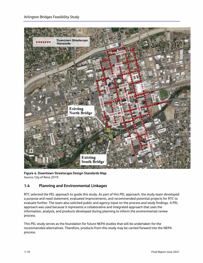
entities. The streetscape standards shall apply to both sides of any section of public street or right-of-way,
designated on Figure 4, with the exception of bridges. Bridges shall be designed and improved in a style
that is complimentary to the design standards contained in the study and to other bridges in the
downtown area. The specific downtown streetscape standards include:
▪ Sidewalks shall have a minimum 6-foot-wide unrestricted pedestrian travel way at all points. Street
furniture, light poles, hydrants, utility boxes, and any other elements or features shall be designed and
installed in such a way as to preserve the minimum 6-foot-wide unrestricted pedestrian travel way.
▪ Sidewalks shall be finished in solid color concrete with a jointing pattern as set forth in the Standard
Details for Public Works Construction.
▪ Landscaping shall be selected and installed in accordance with the appropriate design details
contained in the Streetscape Design Standards.
▪ Street trees shall be selected from the approved City of Reno street tree list.
▪ Irrigation equipment servicing street trees and related landscaping shall be installed in a location
readily accessible to City of Reno maintenance personal.
▪ Trees and tree wells shall be generally centered between, and in line with, streetlights, which are
generally installed at intervals of 20 to 30 feet.
▪ Streetlights shall be generally installed at intervals of 50 to 60 feet and in line with tree wells.
▪ Street furniture and significant art features shall be installed in accordance with the appropriate
design details based on location, available installation space, street function, and other site-specific
factors.
▪ A streetscape configuration shall be generally consistent for the entire length of the block.
Additionally, several concepts and proposals were researched and discussed during the 2019 update but
require additional consideration before adopting. These concepts included technology (e.g., smart
streetlights), special events (e.g., expanded outdoor dining areas called “Streateries“, parklets),
placemaking (e.g., unique art integration), tree list revisions, suspended paving, and alternate soil
treatments.
Arlington Bridges Feasibility Study
1-10 Final Report-June 2021
Figure 4. Downtown Streetscape Design Standards Map Source: City of Reno 2019.
1.4 Planning and Environmental Linkages
RTC selected the PEL approach to guide this study. As part of this PEL approach, the study team developed
a purpose and need statement, evaluated improvements, and recommended potential projects for RTC to
evaluate further. The team also solicited public and agency input on the process and study findings. A PEL
approach was used because it represents a collaborative and integrated approach that uses the
information, analysis, and products developed during planning to inform the environmental review
process.
This PEL study serves as the foundation for future NEPA studies that will be undertaken for the
recommended alternatives. Therefore, products from this study may be carried forward into the NEPA
process.
Arlington Bridges Feasibility Study
Final Report-June 2021 1-11
This PEL Study also aims to identify potential alternatives in advance of secured construction funding,
positioning RTC Washoe to accelerate the environmental analysis and save time in implementing projects
when construction funds are identified.
▪ Defining and developing alternatives
▪ Determining project costs, funding, financing, and delivery options
▪ Engaging with local corridor communities, regional travelers, and other interested stakeholders about
issues and priorities
▪ Identifying significant environmental constraints that may influence design options and/or delay
project development with lengthy environmental reviews
▪ Supporting an efficient transition to NEPA processes, final design, and construction once funding is
identified
The PEL study follows FHWA and NDOT PEL guidance (NDOT 2019) regarding the integration of
transportation planning and the NEPA process; this guidance encourages the use of planning studies to
provide information for incorporation into future NEPA documents (23 Code of Federal Regulations [CFR]
450). FHWA promotes the use of PEL studies, largely to integrate environmental issues and public
involvement with project planning and shorten the time required to take projects from planning to
implementation. The PEL checklist is provided in Appendix A.

Arlington Bridges Feasibility Study
Final Report-June 2021 2-1
2. Corridor Conditions
Technical memoranda prepared for the study are summarized below and provided in Appendix B. In
addition, supplemental information compiled and analyzed during the feasibility study process also are
summarized below.
2.1 Structural Condition
The City of Reno owns the Arlington Avenue Bridges, but NDOT performs the inspections. The standard
frequency for bridge inspections is biennially (every two years), but due to their deteriorated condition,
NDOT is inspecting these bridges annually. During inspection, each bridge component is evaluated on
function, and assigned a condition rating ranging from 9 to 0, where 9 is the best rating possible
(“excellent condition”) and 0 is the worst (“failed condition”). The inspection also includes the assignment
of an overall condition rating, representing the overall condition of the deck, superstructure, and
substructure.
The Sufficiency Rating is used by FHWA as a numerical indicator of a bridge’s sufficiency to remain in
service. The Sufficiency Rating is based upon a 1 to 100 scale (100 being the best), and is calculated using
a formula which incorporates four factors:
▪ Structural Adequacy and Safety (55 percent)
▪ Serviceability (30 percent)
▪ Essentiality for Public Use (15 percent)
▪ Special Reductions (up to 13 percent)
Bridges categorized as structurally deficient or functionally obsolete, with a sufficiency rating of less than
50.0, may qualify for replacement using federal Highway Bridge Program (HBP) funds; those bridges with
a Sufficiency Rating of 80.0 or less are eligible for rehabilitation.
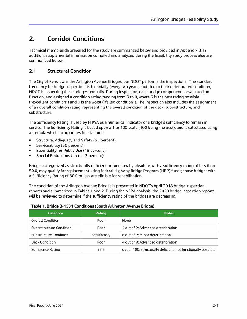
The condition of the Arlington Avenue Bridges is presented in NDOT’s April 2018 bridge inspection
reports and summarized in Tables 1 and 2. During the NEPA analysis, the 2020 bridge inspection reports
will be reviewed to determine if the sufficiency rating of the bridges are decreasing.
Table 1. Bridge B-1531 Conditions (South Arlington Avenue Bridge)
Category Rating Notes
Overall Condition Poor None
Superstructure Condition Poor 4 out of 9; Advanced deterioration
Substructure Condition Satisfactory 6 out of 9; minor deterioration
Deck Condition Poor 4 out of 9; Advanced deterioration
Sufficiency Rating 55.5 out of 100; structurally deficient; not functionally obsolete
Arlington Bridges Feasibility Study
2-2 Final Report-June 2021
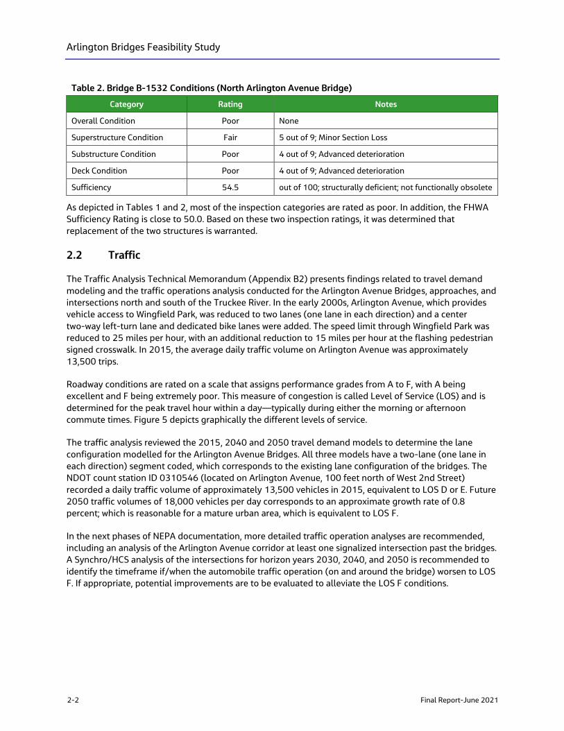
Table 2. Bridge B-1532 Conditions (North Arlington Avenue Bridge)
Category Rating Notes
Overall Condition Poor None
Superstructure Condition Fair 5 out of 9; Minor Section Loss
Substructure Condition Poor 4 out of 9; Advanced deterioration
Deck Condition Poor 4 out of 9; Advanced deterioration
Sufficiency 54.5 out of 100; structurally deficient; not functionally obsolete
As depicted in Tables 1 and 2, most of the inspection categories are rated as poor. In addition, the FHWA
Sufficiency Rating is close to 50.0. Based on these two inspection ratings, it was determined that
replacement of the two structures is warranted.
2.2 Traffic
The Traffic Analysis Technical Memorandum (Appendix B2) presents findings related to travel demand
modeling and the traffic operations analysis conducted for the Arlington Avenue Bridges, approaches, and
intersections north and south of the Truckee River. In the early 2000s, Arlington Avenue, which provides
vehicle access to Wingfield Park, was reduced to two lanes (one lane in each direction) and a center
two-way left-turn lane and dedicated bike lanes were added. The speed limit through Wingfield Park was
reduced to 25 miles per hour, with an additional reduction to 15 miles per hour at the flashing pedestrian
signed crosswalk. In 2015, the average daily traffic volume on Arlington Avenue was approximately
13,500 trips.
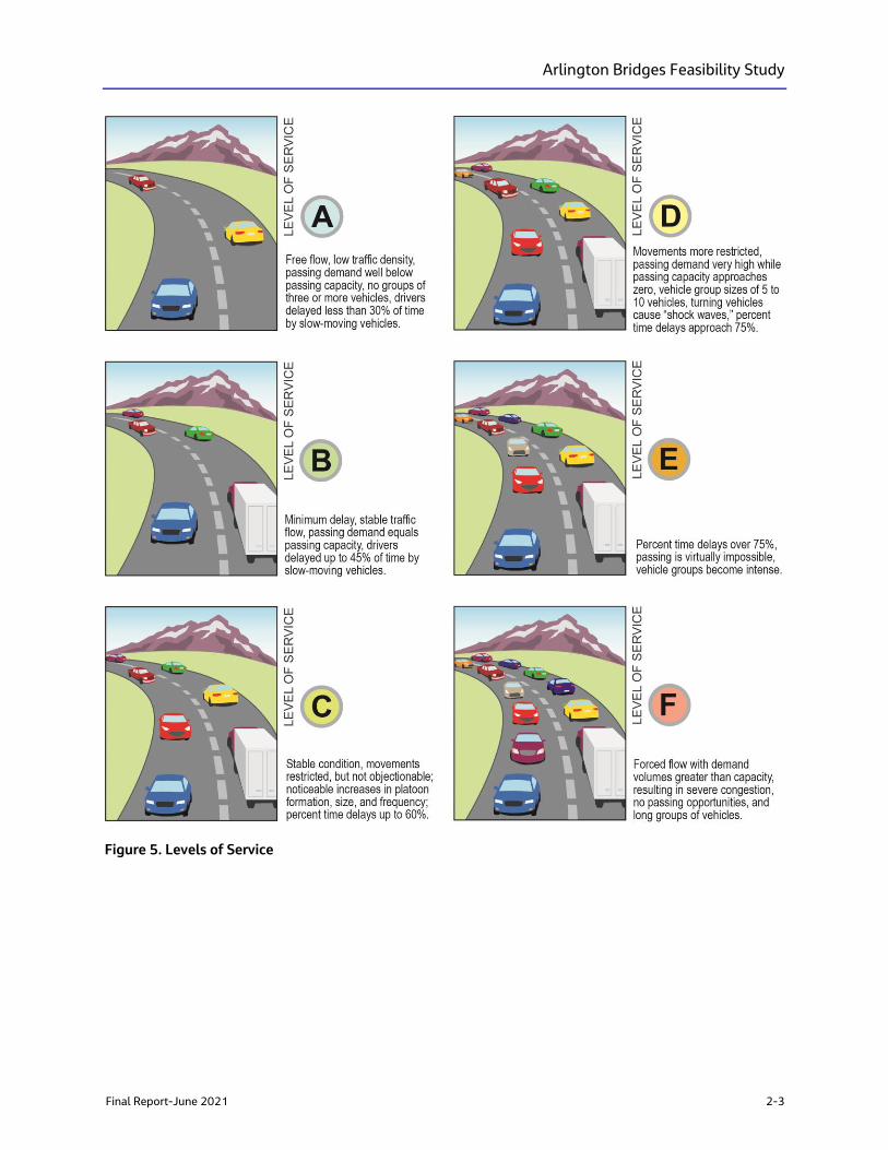
Roadway conditions are rated on a scale that assigns performance grades from A to F, with A being
excellent and F being extremely poor. This measure of congestion is called Level of Service (LOS) and is
determined for the peak travel hour within a day—typically during either the morning or afternoon
commute times. Figure 5 depicts graphically the different levels of service.
The traffic analysis reviewed the 2015, 2040 and 2050 travel demand models to determine the lane
configuration modelled for the Arlington Avenue Bridges. All three models have a two-lane (one lane in
each direction) segment coded, which corresponds to the existing lane configuration of the bridges. The
NDOT count station ID 0310546 (located on Arlington Avenue, 100 feet north of West 2nd Street)
recorded a daily traffic volume of approximately 13,500 vehicles in 2015, equivalent to LOS D or E. Future
2050 traffic volumes of 18,000 vehicles per day corresponds to an approximate growth rate of 0.8
percent; which is reasonable for a mature urban area, which is equivalent to LOS F.
In the next phases of NEPA documentation, more detailed traffic operation analyses are recommended,
including an analysis of the Arlington Avenue corridor at least one signalized intersection past the bridges.
A Synchro/HCS analysis of the intersections for horizon years 2030, 2040, and 2050 is recommended to
identify the timeframe if/when the automobile traffic operation (on and around the bridge) worsen to LOS
F. If appropriate, potential improvements are to be evaluated to alleviate the LOS F conditions.
Arlington Bridges Feasibility Study
Final Report-June 2021 2-3
Figure 5. Levels of Service
Arlington Bridges Feasibility Study
2-4 Final Report-June 2021
2.3 Pedestrian, Bicycle, and Transit Uses
Sidewalks, crosswalks, and dedicated bike lanes are located along Arlington Avenue and along the
adjacent street network (Appendix B3). In addition to the six path connection locations along Arlington
Avenue to the park, the island of Wingfield Park can be accessed by way of three pedestrian bridges that
cross the Truckee River. At-street crosswalks are located at the northern end of the north bridge at the
intersection of W. First Street and at the southern end of the south bridge at Island Avenue. There is also
an existing pathway that passes under the southern end of the north bridge.
Dedicated bicycle lanes begin at W. First Avenue and continue south along Arlington Avenue and Skyline
Boulevard for 4 miles until its terminus with McCarran Boulevards.
RTC Transit Route 6 runs along Arlington Avenue between Plumb Lane and Fourth Street. There are two
transit stops located in Wingfield Park between the two bridges, one northbound and one southbound. The
average ridership is a combined deboarding and onboarding total of approximately 12 people at each
stop throughout the week. Special events such as Artown during the month of July increase ridership using
these transit stops.
2.4 Environmental Resources
This section briefly summarizes existing conditions for key resources identified in the project area, which
include river hydraulics, historic/prehistoric resources, Section 4(f) resources, Section 6(f) resources,
wildlife, wetlands and Waters of the United States, and hazardous materials.
2.4.1 River Hydraulics
The Truckee River Flood Management Authority (TRFMA) maintains a hydraulic model of the Truckee
River for their flood project. The Arlington Avenue Bridges are not a part, nor have they ever been a part, in
TRFMA’s flood project. As such, TRFMA will not require specific water surface elevations or impose specific
flood mitigation requirements, aside from not worsen the existing conditions.
The baseline of the hydrology and hydraulics are HEC-RAS 5.0.3 models distributed by Carson-Truckee
Water Conservancy District (CTWCD) dated June 21, 2018. This HEC-RAS model extends from Keystone
Avenue downstream to just beyond Glendale Avenue. Any hydrology, hydraulics, new adjacent
development, LiDAR data or water surface elevation (WSEL) changes after June 21, 2018, including
updates to the Glendale Weir were not incorporated into the model. The one exception is the construction
of the Whitewater Kayak Park in 2004, which was incorporated into the CTWCD model provided to Jacobs.
The complete hydraulic report is attached in Appendix B4.
A Section 408 permit is required as this Project alters the USACE Civil Works Project. The Section 408
permit will go through the local sponsor, which is the CTWCD. The CTWCD requires analysis for 14,000 cfs
for this location of the Truckee River.
Local design standards, including both NDOT and the Truckee Meadows Regional Drainage Manual, have
criteria for 2 feet of freeboard during the 100-year flood event, when possible. During final design, the
agencies will agree upon the freeboard requirement to use, as was done for the recently constructed
Virginia Street Bridge, which had a Project specific design requirement of 1 foot of freeboard during the
100-year storm event.
Arlington Bridges Feasibility Study
Final Report-June 2021 2-5
Therefore, the new structures must be analyzed for both the CTWCD-required 14,000 cfs scenario, and the
100-year flood scenario to ensure both conditions are met. As the Project continues to develop, the design
elements of the bridges will inform the freeboard discussion and incorporate the necessary engineering
requirements.
2.4.2 Historic/Prehistoric Resources
Historic properties are protected under Section 106 of the National Historic Preservation Act (NHPA) of
1966 (as amended) and other statutes, as well as Section 4(f) as amended and codified in the U.S.
Department of Transportation (USDOT) Act of 1966, 49 U.S. Code (USC) 303 (c). Section 106 of the NHPA
requires federal agencies to consider the effects that their undertakings have on historic properties, which
are those properties that are included in, or eligible for, the National Register of Historic Places (NRHP).
This review process ensures that federal agencies identify any potential conflicts between their
undertakings and historic preservation and resolve any conflicts in the public interest. Under this feasibility
study, a preliminary desktop review of available cultural resources data was conducted for the project area
(Appendix B5). The research included review of available data sets to identify cultural resources and
surveys completed within the project area, historic U.S. Geological Survey topographic maps and aerial
imagery, and recent street view photographs.
The desktop review indicated that numerous cultural studies have been completed in the vicinity of the
project area. Those studies focused on the built environment; no studies were performed for
archaeological sites possibly due to the urban nature of the project area. Five previously evaluated cultural
resources are located in the project area, and include the South Arlington Avenue Bridge, Winfield Park,
North Arlington Avenue Bridge, Wingfield Park Dam, and Truckee River Retaining Walls. All five resources
have been previously determined as not eligible for the NRHP. No prehistoric or archaeological resources
have been identified in the immediate project area and pedestrian archaeological surveys are unlikely to
identify any previously unrecorded resources given the high degree of development in the area.
2.4.3 Section 4(f) and 6(f) Resources
Park and recreational resources are protected by Section 4(f) of the USDOT Act of 1966 or by Section 6(f)
of the Land and Water Conservation Act. Section 4(f) governs the use of land from publicly owned parks,
recreation areas, wildlife and waterfowl refuges, and public or private historic sites. Several recreational
properties under the City of Reno’s jurisdiction are located within 0.25 mile of the project area:
▪ Barbara Bennett Park, Neighborhood Park, 400 Island Avenue
▪ Bicentennial Park, Neighborhood Park, 10 Ralston Street
▪ Downtown Plaza, Pocket Park, 10 N. Virginia Street
▪ Fulton Corner, Pocket Park, W. 1st Street and Arlington Avenue
▪ Lunsford Triangle, Pocket Park, Riverside Drive and Washington Street
▪ Powning Park, Pocket Park, 150 S. Virginia Street
▪ Reno Whitewater Park, Sports Complex, Truckee River
▪ Truckee River Greenbelt/Riverside Drive Park, Neighborhood Park, 650 Riverside Drive
▪ Truckee River Trail, Hiking Trail, Riverside Drive to Lake Street
▪ West Street Plaza, Pocket Park, 220 W. 1st Street
▪ Wingfield Park, Neighborhood Park, 2 S. Arlington Avenue
Section 6(f) requires that the conversion of lands or facilities acquired or improved with Land and Water
Conservation Funds (LWCF) be coordinated with the U.S. Department of Interior. Only one property within
0.25 mile of the Project is listed as having used LWCF funding, the Truckee River Greenbelt located along
the north shore of the Truckee River from Booth Street to Ralston Street. However, according to the City of
Reno Parks Department Parks Manager, no LWCF funds were used on properties within the project area.
Arlington Bridges Feasibility Study
2-6 Final Report-June 2021
During the NEPA analysis, a review of Section 4(f) and Section 6(f) resources will be conducted to
determine if there are additional resources that should be considered and assess potential impacts to the
identified resources. (Appendix B6)
2.4.4 Wildlife and Aquatic Resources
A desktop review of publicly available data pertaining to special-status species (i.e., state- or federally
listed endangered, threatened, or candidate species) and aquatic resources was conducted (Appendix B6).
A review of the Nevada Natural Heritage Program biological species observation dataset and the United
States Fish and Wildlife Service (USFWS) Information for Planning and Consultation (IPaC) database was
conducted to assess the potential presence of special-status species and sensitive habitats, as well as
species protected under the Migratory Bird Treaty Act (MBTA). This review identified 11 state- or federally
protected special-status species with some potential to occur within or adjacent to the project area, but no
state- or federally listed species were observed during the July 2019 field visit
Results of the desktop review identified 11 state or federally protected special-status species with some
potential to occur within 2 miles of the project area. No state or federally listed species were observed
within the project area during the field evaluation; however, suitable habitats for Lahontan cutthroat trout
(Oncorhynchus clarkii henshawi) and Cui-ui sucker (Chasmistes cujus), which are federally listed fish
species, is present within the entire Truckee River. Additionally, suitable nesting habitat for birds subject to
federal protection under the MBTA was found to be present within the project area. No nesting bird activity
was observed during the site evaluation, and nesting birds identified near the project area are expected to
be acclimated to disturbance from adjacent commercial and residential activities.
The Truckee River is approximately 193 feet wide west of the Project, breaking into two waterways
approximately 105 feet wide to the north and 49 feet wide to the south, combining into one 230-foot
wide waterway east of the project area. The Truckee River is highly modified in the project area, with most
of the banks fully cemented or rip rap/cement filled. Suitable habitats for the following special-status
species were observed within and adjacent to the project area:
▪ Suitable nesting habitat for birds subject to the MBTA occurs within and adjacent to the project area,
although no nesting bird activity was observed during the July 2019 survey.
▪ Nesting birds identified near the project survey area are expected to be acclimated to disturbance
from pedestrian activity on the bridges, and adjacent commercial and residential activities.
▪ The Truckee River was originally home to the Lahontan cutthroat trout and cui-ui sucker, and potential
project impacts would be addressed with a biological assessment submitted to the United States Fish
and Wildlife Service (USFWS) for review and approval.
Additional details regarding environmental resources, including survey requirements, special-status
species, and recommendations are presented in the Environmental Resources Technical Memorandum in
Appendix B7.
2.4.5 Wetlands and Waters of the United States
In support of anticipated permitting requirements, a review of United States Geological Survey (USGS)
topographic maps, USGS National Hydrography Dataset, and USFWS National Wetlands Inventory maps
was conducted to assess the presence of mapped aquatic resources in the vicinity of the project area. A
field evaluation of the project area was conducted to identify water resources, including potential
wetlands.
Arlington Bridges Feasibility Study
Final Report-June 2021 2-7
The Truckee River, although highly modified within the project area (most of the river banks are fully
cemented or rip rap/cement fill) is a USACE-regulated aquatic resource as it is a Traditional Navigable
Water, and thus is subject to regulation under Clean Water Act (CWA) Section 404. No potential wetlands
were identified within the project area.
As part of the CWA permit process, the RTC will need to analyze the Project’s potential impacts upon water
resources, biological, and cultural resources (i.e. Wetland Delineation, Biological Assessment, and Cultural
Resources Report) to support the USACE Endangered Species Act and NHPA consultation.
2.4.6 Land Use
The Project is not expected to change existing or future land use in the area. Existing land uses are
expected to remain the same in the future, as downtown mixed-use properties will continue to dominate
the surrounding area. The Project will continue to support and provide access to the recreational areas
along the river. (See Appendix B8).
2.4.7 Hazardous Materials
A hazardous materials screening assessment of the project area was conducted. The assessment included
a site reconnaissance and records review to identify hazardous substances or petroleum products
potentially present in the project area. Hazardous materials concerns include the potential presence of
contaminated soil at a possible staging area (291 Court Street), and concerns related to the potential
presence of asbestos and lead-based paint in existing bridges, foundations, and abutments. As the Project
moves forward, materials management may be warranted if project-related soil disturbance is proposed
where existing contamination has been identified. In addition, asbestos and lead surveys would be
completed on the existing bridge structures prior to demolition. For additional details on hazardous
materials potentially present in the project area, refer to the Hazardous Materials Technical Memorandum
in Appendix B9.

Arlington Bridges Feasibility Study
Final Report-June 2021 3-1
3. Alternatives Development and Screening Process
As part of this feasibility study, RTC conducted planning, engineering, and outreach efforts between
December 2018 and April 2021. These efforts built on the goals, objectives, need, and purpose identified
in the project kick-off, agency, stakeholder, and community meetings. Presentation materials prepared for
these meetings and meeting summaries are provided in Appendix E.
Bridge alternatives for the north bridge that were presented and discussed during the December 19, 2019
public meeting/open house and the February 6, 2020 Stakeholder Working Group (SWG) Meeting #1
included five alternatives: 1) a Single Pier, 2) a Clear Span, 3) an Underdeck Arch, 4) a Tied Arch, and 5) an
Elevated Bridge. During these meetings, the bridge alternatives/concepts were presented for input and
consideration, but discussions about possible differences between engineering requirements or
environmental considerations did not occur because those details had not yet been developed and
evaluated. The underdeck arch and tied arch concepts are variants of the clear span alternative, but with
different above- and below- deck superstructure features. These five alternatives were carried forward into
the Technical Advisory Committee (TAC-1) and TAC-2 meetings held on July 15 and August 31, 2020,
respectively. Renderings of each alternative are provided in Appendix C.
The purpose of the July 15, 2020 TAC-1 meeting was to present and gain consensus on the permitting
and regulatory requirements for the Project, which were discussed as environmental and engineering
design constraints and criteria during SWG-1. During the TAC-1 meeting, which 20 people attended, the
permitting and regulatory requirements were determined to be generally similar between the alternatives,
with a few exceptions. The Tied Arch (Alternative 4) and Elevated Bridge (Alternative 5) were determined
to be more challenging in terms of permitting (Section 404) and viewshed impacts, and they imposed
additional restrictions on required maintenance (bridge and river/park) and river access for
debris/sediment removal. TAC-1 members did not score the alternatives. There was discussion during the
meeting specific to the federal funding in the Project and the potential federal agency touch points during
the permitting phase of the projects, specifically Section 401 and 404 permits.
During the TAC-1 meeting, it was determined that FHWA would be the lead agency for this study and
NDOT would sign the PEL checklist. Additionally, it was determined that the RTC would be the permittee
for the USACE Sections 408 and 404, Nevada Division of Environmental Protection (NDEP) Section 401,
working-in-waterways and groundwater discharge permits, and the construction contractor will be
responsible for preparing, submitting, and complying with the RTC stormwater permit as the permittee. An
evaluation of historical significance of the bridges was also discussed. The bridges were evaluated for
historical significance as part of a Nevada statewide survey and concurred with by the Nevada State
Historic Preservation Office (SHPO) as not meeting the criteria for listing on the NRHP.
Bridge and roadway elements were the focus of the August 31, 2020 TAC-2 meeting. The purpose of the
meeting was to discuss bridge and roadway elements, explain evaluation attributes, review
alternative-specific qualitative attributes and concept evaluations and concept scoring results, and
recommend alternatives to carry forward. The RTC prepared and submitted preliminary meeting materials
to TAC-2 members prior to the meeting, which included 1) a blank score card for member review,
completion and return; 2) qualitative attribute guidelines to assist with scoring; and 3) concept evaluation
sheets for the five initial alternatives. The score card defined eight attributes for screening plus undefined
attributes “Y“ and “Z“ for reviewer-specific input.
During this meeting, the five initial alternatives were further refined by bridge type that resulted in a total
of nine concepts being evaluated for the north bridge during the TAC-2 meeting. These concepts included
three Single Pier Concepts (precast concrete girders, cast-in-place concrete box, and steel I-girders), three
Arlington Bridges Feasibility Study
3-2 Final Report-June 2021
Clear Span Concepts (underdeck arch, rigid frame, and tied arch), and three Elevated Bridge Concepts
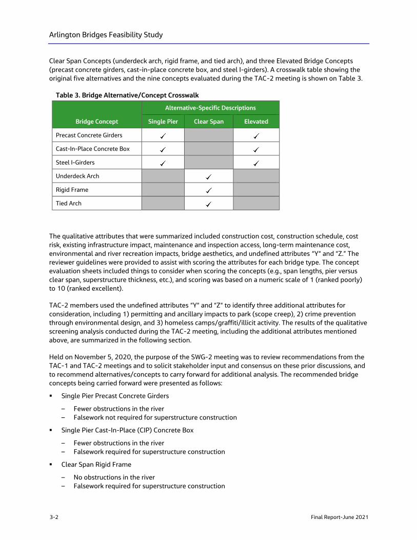
(precast concrete girders, cast-in-place concrete box, and steel I-girders). A crosswalk table showing the
original five alternatives and the nine concepts evaluated during the TAC-2 meeting is shown on Table 3.
Table 3. Bridge Alternative/Concept Crosswalk
Bridge Concept
Alternative-Specific Descriptions
Single Pier Clear Span Elevated
Precast Concrete Girders
Cast-In-Place Concrete Box
Steel I-Girders
Underdeck Arch
Rigid Frame
Tied Arch
The qualitative attributes that were summarized included construction cost, construction schedule, cost
risk, existing infrastructure impact, maintenance and inspection access, long-term maintenance cost,
environmental and river recreation impacts, bridge aesthetics, and undefined attributes “Y“ and “Z.” The
reviewer guidelines were provided to assist with scoring the attributes for each bridge type. The concept
evaluation sheets included things to consider when scoring the concepts (e.g., span lengths, pier versus
clear span, superstructure thickness, etc.), and scoring was based on a numeric scale of 1 (ranked poorly)
to 10 (ranked excellent).
TAC-2 members used the undefined attributes “Y“ and “Z“ to identify three additional attributes for
consideration, including 1) permitting and ancillary impacts to park (scope creep), 2) crime prevention
through environmental design, and 3) homeless camps/graffiti/illicit activity. The results of the qualitative
screening analysis conducted during the TAC-2 meeting, including the additional attributes mentioned
above, are summarized in the following section.
Held on November 5, 2020, the purpose of the SWG-2 meeting was to review recommendations from the
TAC-1 and TAC-2 meetings and to solicit stakeholder input and consensus on these prior discussions, and
to recommend alternatives/concepts to carry forward for additional analysis. The recommended bridge
concepts being carried forward were presented as follows:
▪ Single Pier Precast Concrete Girders
– Fewer obstructions in the river
– Falsework not required for superstructure construction
▪ Single Pier Cast-In-Place (CIP) Concrete Box
– Fewer obstructions in the river
– Falsework required for superstructure construction
▪ Clear Span Rigid Frame
– No obstructions in the river
– Falsework required for superstructure construction
Arlington Bridges Feasibility Study
Final Report-June 2021 3-3
Included with the SWG-2 presentation materials were plan, elevation, and typical section views for each of
the three concepts being carried forward to assist participants with visualizing the different aspects of the
concepts. At the conclusion of the SWG-2 meeting, participants agreed with the scoring and evaluation of
concepts, and the concepts to carry forward for further analysis. The group discussed a variety of topics
from potential designs to reduce graffiti, potential traffic impacts during construction, permitting
challenges, and potential aesthetic designs.
The SWG-3 meeting, see Appendix E, focused on project aesthetics. A summary of the process and how
the aesthetics coordinate with the Downtown Streetscape Standards is provided in Appendix F.
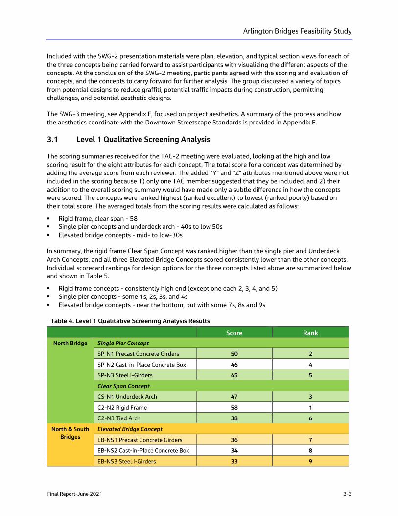
3.1 Level 1 Qualitative Screening Analysis
The scoring summaries received for the TAC-2 meeting were evaluated, looking at the high and low
scoring result for the eight attributes for each concept. The total score for a concept was determined by
adding the average score from each reviewer. The added “Y“ and “Z“ attributes mentioned above were not
included in the scoring because 1) only one TAC member suggested that they be included, and 2) their
addition to the overall scoring summary would have made only a subtle difference in how the concepts
were scored. The concepts were ranked highest (ranked excellent) to lowest (ranked poorly) based on
their total score. The averaged totals from the scoring results were calculated as follows:
▪ Rigid frame, clear span - 58
▪ Single pier concepts and underdeck arch - 40s to low 50s
▪ Elevated bridge concepts - mid- to low-30s
In summary, the rigid frame Clear Span Concept was ranked higher than the single pier and Underdeck
Arch Concepts, and all three Elevated Bridge Concepts scored consistently lower than the other concepts.
Individual scorecard rankings for design options for the three concepts listed above are summarized below
and shown in Table 5.
▪ Rigid frame concepts - consistently high end (except one each 2, 3, 4, and 5)
▪ Single pier concepts - some 1s, 2s, 3s, and 4s
▪ Elevated bridge concepts - near the bottom, but with some 7s, 8s and 9s
Table 4. Level 1 Qualitative Screening Analysis Results
Score Rank
North Bridge Single Pier Concept
SP-N1 Precast Concrete Girders 50 2
SP-N2 Cast-in-Place Concrete Box 46 4
SP-N3 Steel I-Girders 45 5
Clear Span Concept
CS-N1 Underdeck Arch 47 3
C2-N2 Rigid Frame 58 1
C2-N3 Tied Arch 38 6
North & South
Bridges
Elevated Bridge Concept
EB-NS1 Precast Concrete Girders 36 7
EB-NS2 Cast-in-Place Concrete Box 34 8
EB-NS3 Steel I-Girders 33 9
Arlington Bridges Feasibility Study
3-4 Final Report-June 2021
For the range of individual attribute results, the average score for construction costs, schedule, and cost
risks were ranked very well for the clear span (rigid frame) and fair for the Single Pier Concepts, with the
Elevated Bridge Concepts scoring the lowest. A similar trend was noted for the existing infrastructure
impacts, maintenance and inspection access, and long-term maintenance costs. There was a fair amount
of range in the scoring for environmental impacts, recreation impacts, and bridge aesthetics, but the
averages were consistent with the overall ranking of the concepts.
It was determined that the individual scores were consistent with the averages, and scores with the three
added attributes were higher because they were mathematically added to those concepts, but the overall
ranking was unchanged except for the reversal of concepts 3 and 4. In summary, it was concluded that no
further consideration would be given to all three Elevated Bridge Concepts, the clear span underdeck and
Tied Arch concepts, and the single pier steel I-girder concepts. The analysis, based on the discussion from
the group, determined that the clear span rigid frame, single pier precast concrete girder, and
cast-in-place concrete box would be carried forward into the feasibility study for more detailed analysis.
3.2 Level 2 Quantitative Screening Analysis:
The Level 1 screening process resulted in two bridge types, the single pier and the clear span to be carried
forward for further analysis.
3.2.1 Single Pier
The Single Pier concept (for the North Bridge) provides many advantages:
▪ Park access across Arlington Avenue is maintained. There are currently six locations, three on either
side, to access the park from the sidewalk along Arlington Avenue between Island Avenue and First
Street. The single pier concept allows the roadway elevation to remain close to the existing elevation
and preserves these six access points. In contrast, the elevated bridge concept would raise Arlington
Avenue approximately 10 feet between the two bridges, cutting off these six access points.
▪ Park functionality is maintained. With minimal changes to the roadway elevation, there will not be
large intrusive fill slopes impacting the available park space. In addition, there are many special events
when Arlington Avenue is closed to vehicular traffic and pedestrians and vendors occupy the roadway
area and allow free movement throughout the park amenities on either side of the roadway. In
contrast, the elevated bridge concept would raise Arlington Avenue approximately 10 feet between
the bridges, and the resulting fill slopes would impact as wide as 40 feet on both sides of the roadway.
▪ At the southern abutment of the north bridge, there is an existing path underneath the bridge. The
single pier bridge type allows maximum head room without raising the profile of the roadway.
▪ The single pier support allows a thinner deck section and maximizes clearance under the bridge, in
conjunction with reducing the number of piers from two to one, improving hydraulics to obtain the
required freeboard.
▪ The single pier support provides additional strength that allows for increased sidewalk widths or river
overlooks.
▪ River and park viewsheds are maintained. Minimal changes to the roadway elevation preserve
viewsheds from one side of the park to the other, and from the bridges and roadway to the river.
▪ Reducing the number of piers from two to one at the north bridge increases the river viewshed under
the north bridge.

Arlington Bridges Feasibility Study
Final Report-June 2021 3-5
▪ Although not intuitive as an advantage, the single pier will allow for the collection of debris during
flood events and the opportunity to remove it before going downstream to other pinch-points where
the river narrows, or other locations where removal cannot be accomplished, or cause damage.
▪ Similar look to the existing north bridge which has two piers.
▪ Preliminary cost estimates put the single pier bridge type in the $17 million to $35 million range, the
cheapest alternative.
The disadvantages of the Single Pier concept include:
▪ The pier will require special construction considerations.
▪ This single pier surface may also be prone to graffiti.
3.2.2 Clear Span
The Clear Span concept (for north and south bridges) also provides many advantages:
▪ Similar to the single span concept, park access across Arlington Avenue is maintained. There are
currently eight locations, four on either side, to access the park from the sidewalk along Arlington
Avenue between Island Avenue and First Street. The clear span concept requires the roadway
elevation to be raised slightly but preserves these eight access points.
▪ Park functionality is maintained. With minimal changes to the roadway elevation, there will not be
large intrusive fill slopes impacting the available park space. In addition, there are many special events
when Arlington Avenue is closed to vehicular traffic, and pedestrians and vendors occupy the roadway
area and allow free movement throughout the park amenities on either side of the roadway.
▪ The clear span maximizes the available hydraulic area under the bridge will minimize the need for
profile adjustments; however, this will be offset with the increased deck thickness.
▪ River and park viewsheds are maintained. Minimal changes to the roadway elevation preserve
viewsheds from one side of the park to the other, and from the bridges and roadway to the river.
▪ Maintaining a clear span bridge for the south bridge will preserve the local hydraulics within the river
at this location and not have any adverse impacts to the hydraulics of the Kayak Park Course, just
upstream of the south bridge.
▪ The clear span provides unobstructed views of the river.
▪ Preliminary cost estimates put the clear span bridge type in the $18 million to $39 million range.
The disadvantages of the Clear Span (for the north bridge) concept include:
▪ At the southern abutment of the north bridge, there is an existing pedestrian path underneath the
bridge. The clear span bridge type requires a thicker deck section overall than the single pier, and also
an extra thicker section at the bridge abutments, which will impact the available head room under the
bridge and require the roadway profile to be raised accordingly.
▪ Without pier support, to provide additional strength for increased sidewalk widths or river overlooks,
the deck thickness becomes even thicker, and at some point, impossible.
▪ Although not intuitive as a disadvantage, without a pier to collect debris during flood events, there is
no opportunity to remove it before going downstream to other pinch-points where the river narrows,
or other locations where removal cannot be accomplished, and cause damage.
When comparing the positive and negative attributes of the single pier vs the clear span, the preferred
bridge type for the north bridge is the Single Pier. The south bridge will remain a clear span with a
superstructure that matches what is chosen for the north bridge (i.e. cast-in-place, or precast). This is
Arlington Bridges Feasibility Study
3-6 Final Report-June 2021
supported by the public as seen in the results of the survey questions asked in conjunction with the second
public meeting presentation recording posted on the website for 30 days.
The Single Pier and Clear Span concepts are feasible. However, based on the level 2 screening criteria and
the public input, the Single Pier alternative for the north bridge and a comparable single-span precast or
cast-in-place alternative for the south bridge will be recommended for further design and consideration in
NEPA.
3.3 Roadway and Pedestrian Concepts
Development of alternatives and concepts for the Arlington Avenue Bridges Feasibility Study were
developed to meet the purpose and need of the Project. The Arlington Avenue Bridges Feasibility Study
identifies transportation focused purpose elements. Concepts that were developed but did not meet
purpose and need elements were not considered viable and deemed not recommended and eliminated
from further consideration in the alternatives development process.
3.3.1 Additional Path Under South Bridge
One element that was suggested for further analysis during the NEPA process as engineering and design
advances, is the addition of a path under the northern end of the south bridge. Improving hydrologic flow
of the Truckee River was identified as one purpose of this Project. The addition of a multi-use path closer
to the Truckee River and the necessary infrastructure to provide safety to the users of the path would
conflict with this purpose. The addition of a path that could flood seasonally is a negative to pedestrian
safety and access. The additional infrastructure, columns, or supports could also create a snag point that
could disrupt debris flows in a flood event. The additional infrastructure (longer bridge, additional walls)
will increase construction costs, and may impact constructability. Because of these constraints, path
concepts will need further vetting in the NEPA process.
3.4 Constructability Review
For each alternative during level 2 screening, constructability was reviewed. Constructability is an
important consideration in capital projects because it helps refine cost estimates and inform potential
environmental impacts from design requirements.
Construction of a clear span structure would avoid the need to construct a pier within the middle of the
river. However, the large deck thickness, nearly twice as thick as the deck section needed for the single pier
alternate, and reduction of overhead clearance of the clear span structure are considered more significant
issues than constructing a pier in the river.
For the single pier bridge, there are two options for design: either a cast-in-place concrete box girder or
precast concrete girders. Choosing between them will come down to weighing aesthetics, cost, and
construction risk. Environmental and long-term maintenance considerations are essentially equal.
The cast-in-place box girder may be preferred aesthetically (cleaner lines in a river setting, less of a
“highway bridge” look), but there’s more risk in construction because it requires temporary falsework in the
river channel. During the construction of the Center Street Bridge, approximately ¼-mile downstream, a
flood event occurred during construction when falsework was in the river. A cast-in-place box girder bridge
is typically more economical to build than a precast girder bridge. A cast-in-place box girder bridge is
feasible for the Arlington Avenue Bridges if preferred aesthetically, but it may make it a two-season
project (build the abutments and pier in season one, wait for season two to put falsework in the channel to
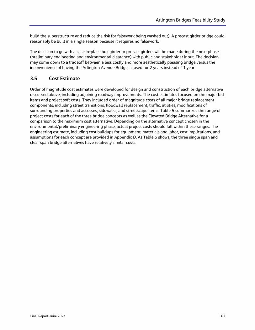
Arlington Bridges Feasibility Study
Final Report-June 2021 3-7
build the superstructure and reduce the risk for falsework being washed out). A precast girder bridge could
reasonably be built in a single season because it requires no falsework.
The decision to go with a cast-in-place box girder or precast girders will be made during the next phase
(preliminary engineering and environmental clearance) with public and stakeholder input. The decision
may come down to a tradeoff between a less costly and more aesthetically pleasing bridge versus the
inconvenience of having the Arlington Avenue Bridges closed for 2 years instead of 1 year.
3.5 Cost Estimate
Order of magnitude cost estimates were developed for design and construction of each bridge alternative
discussed above, including adjoining roadway improvements. The cost estimates focused on the major bid
items and project soft costs. They included order of magnitude costs of all major bridge replacement
components, including street transitions, floodwall replacement, traffic, utilities, modifications of
surrounding properties and accesses, sidewalks, and streetscape items. Table 5 summarizes the range of
project costs for each of the three bridge concepts as well as the Elevated Bridge Alternative for a
comparison to the maximum cost alternative. Depending on the alternative concept chosen in the
environmental/preliminary engineering phase, actual project costs should fall within these ranges. The
engineering estimate, including cost buildups for equipment, materials and labor, cost implications, and
assumptions for each concept are provided in Appendix D. As Table 5 shows, the three single span and
clear span bridge alternatives have relatively similar costs.
Arlington Bridges Feasibility Study
3-8 Final Report-June 2021
Table 5. Order of Magnitude Project Cost Ranges
Single Pier-Opt. 1
Precast Girder
Single Pier-Opt. 2
Cast-In-Place Box
Clear Span-Opt. 2
Rigid Frame
Elevated Bridge
CIP Box
-30% +50% -30% +50% -30% +50% -30% +50%
Preconstruction - Design/Permits $1,544,000 $3,308,000 $1,544,000 $3,308,000 $1,544,000 $3,308,000 $1,817,000 $3,893,000
Mobilization $2,349,000 $5,034,000 $2,349,000 $5,034,000 $2,380,000 $5,099,000 $2,384,000 $5,109,000
Environmental $690,000 $1,479,000 $690,000 $1,479,000 $651,000 $1,395,000 $735,000 $1,575,000
Earthwork $1,364,000 $2,924,000 $1,361,000 $2,917,000 $1,361,000 $2,917,000 $1,422,000 $3,046,000
Structural $3,422,000 $7,333,000 $2,937,000 $6,293,000 $3,847,000 $8,244,000 $5,409,000 $11,592,000
Roadway $903,000 $1,934,000 $526,000 $1,126,000 $523,000 $1,122,000 $1,127,000 $2,415,000
Aesthetics $308,000 $660,000 $282,000 $605,000 $309,000 $663,000 $387,000 $829,000
Drainage $719,000 $1,541,000 $658,000 $1,411,000 $721,000 $1,546,000 $903,000 $ 1,934,000
Utilities/Electrical $257,000 $550,000 $235,000 $504,000 $258,000 $552,000 $322,000 $691,000
Traffic Control $822,000 $1,761,000 $753,000 $1,613,000 $824,000 $1,767,000 $1,031,000 $2,210,000
Landscaping $154,000 $330,000 $141,000 $302,000 $155,000 $331,000 $645,000 $1,381,000
Signing/Striping $205,000 $440,000 $188,000 $403,000 $206,000 $442,000 $258,000 $553,000
Contingency- Detail Scope $3,184,000 $6,824,000 $2,916,000 $6,249,000 $3,195,000 $6,846,000 $4,110,000 $8,807,000
Project Management/Construction
Management $2,122,000 $4,548,000 $1,948,000 $4,174,000 $2,129,000 $ 4,563,000 $ 2,724,000 $5,837,000
TOTAL $18,043,000 $38,666,000 $16,528,000 $35,418,000 $18,103,000 $38,795,000 $23,274,000 $49,872,000
Notes:
Order of Magnitude (Accuracy Range: -30% / +50%).
Includes North and South Bridges and Roadway in-between
Arlington Bridges Feasibility Study
Final Report-June 2021 3-9
3.6 Local, State, and Federal Funding
Federal transportation legislation (Fixing America’s Surface Transportation Act – FAST Act) requires that
the 2040 RTP be based on a financial plan that demonstrates how the program of projects can be paid for
and implemented. RTC funds its projects through a mix of local, state, and federal funding. The allowable
use for the various funding sources is limited by statute, regulation, or state constitutional provisions.
3.6.1 Local and State Funding
Regional funding sources include fuel tax, general funds from the local agencies, sales and use tax, and
other revenue such as regional road impact fees (RRIF) paid by private developments, and the Truckee
River Flood Project. In 2008, Washoe County voters approved the indexing of fuel taxes to keep pace with
inflation.
State funding sources include gas tax, special fuel (diesel) tax, vehicle registration fees, motor carrier fees,
driver’s license fees, and petroleum cleanup funds. The majority of state funding is applicable to street and
highway projects.
Competitive Highway Bridge Program
The Competitive Highway Bridge Program (HBP) is a discretional competitive grant program that was last
funded in FY 2018. NDOT administers federal HBP funding at the state level, and the program provides
funds for highway bridge replacement and rehabilitation projects on public roads. No information is
currently available on whether this program will be funded under the Biden administration and if so, when
a NOFO is likely to be issued.
3.6.2 Federal Funding
The primary funding source provided by the federal government is the Highway Trust Fund (HTF). Federal
motor fuel taxes are the major source of income into the HTF. Other funding comes from Congressional
appropriations or from transfers from the general fund to the HTF.
The Fixing America’s Surface Transportation (FAST) Act, signed into law on December 4, 2015, provides
long-term funding for surface transportation infrastructure planning and investment. The FAST Act
authorized $305 billion for fiscal year 2016 through 2020 and was extended one more year through
September 30, 2021. FAST Act programs generally available to the RTC for the Arlington Avenue Bridge
Project are described below. Generally, federal funding programs require a state or local contribution of
funds toward the cost of a project, which is referred to as matching funds. The typical match for street and
highway programs is five percent. The FAST Act also provides for competitive grants such as RAISE Grants,
formerly known as BUILD grants, that the RTC competes for on a national level.
Surface Transportation Program
The Surface Transportation Program (STP) is the common name for the Surface Transportation Block
Grant (STBG) program. It is a federal aid program administered by the FHWA. The program provides
“flexible funding that may be used by States and localities for projects to preserve and improve the
conditions and performance on any Federal-aid highway, bridge and tunnel projects on any public
road…”. No information is currently available on the continuation of this program under the Biden
Administration.
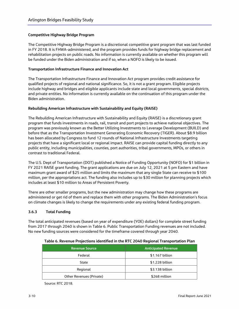
Arlington Bridges Feasibility Study
3-10 Final Report-June 2021
Competitive Highway Bridge Program
The Competitive Highway Bridge Program is a discretional competitive grant program that was last funded
in FY 2018. It is FHWA-administered, and the program provides funds for highway bridge replacement and
rehabilitation projects on public roads. No information is currently available on whether this program will
be funded under the Biden administration and if so, when a NOFO is likely to be issued.
Transportation Infrastructure Finance and Innovation Act
The Transportation Infrastructure Finance and Innovation Act program provides credit assistance for
qualified projects of regional and national significance. So, it is not a grant program. Eligible projects
include highway and bridges and eligible applicants include state and local governments, special districts,
and private entities. No information is currently available on the continuation of this program under the
Biden administration.
Rebuilding American Infrastructure with Sustainability and Equity (RAISE)
The Rebuilding American Infrastructure with Sustainability and Equity (RAISE) is a discretionary grant
program that funds investments in roads, rail, transit and port projects to achieve national objectives. The
program was previously known as the Better Utilizing Investments to Leverage Development (BUILD) and
before that as the Transportation Investment Generating Economic Recovery (TIGER). About $8.9 billion
has been allocated by Congress to fund 12 rounds of National Infrastructure Investments targeting
projects that have a significant local or regional impact. RAISE can provide capital funding directly to any
public entity, including municipalities, counties, port authorities, tribal governments, MPOs, or others in
contrast to traditional Federal.
The U.S. Dept of Transportation (DOT) published a Notice of Funding Opportunity (NOFO) for $1 billion in
FY 2021 RAISE grant funding. The grant applications are due on July 12, 2021 at 5 pm Eastern and have
maximum grant award of $25 million and limits the maximum that any single State can receive to $100
million, per the appropriations act. The funding also includes up to $30 million for planning projects which
includes at least $10 million to Areas of Persistent Poverty.
There are other smaller programs, but the new administration may change how these programs are
administered or get rid of them and replace them with other programs. The Biden Administration’s focus
on climate changes is likely to change the requirements under any existing federal funding program.
3.6.3 Total Funding
The total anticipated revenues (based on year of expenditure (YOE) dollars) for complete street funding
from 2017 through 2040 is shown in Table 6. Public Transportation Funding revenues are not included.
No new funding sources were considered for the timeframe covered through year 2040.
Table 6. Revenue Projections identified in the RTC 2040 Regional Transportation Plan
Revenue Source Anticipated Revenue
Federal $1.167 billion
State $1.228 billion
Regional $3.138 billion
Other Revenues (Private) $268 million
Source: RTC 2018.
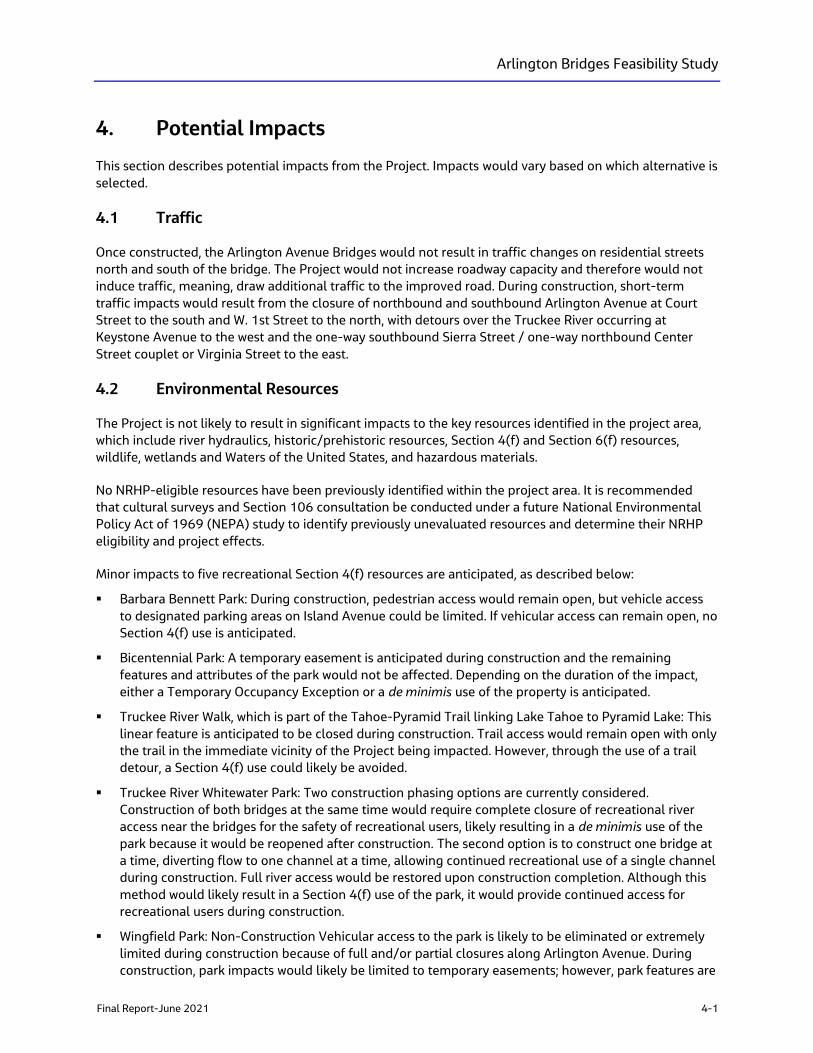
Arlington Bridges Feasibility Study
Final Report-June 2021 4-1
4. Potential Impacts
This section describes potential impacts from the Project. Impacts would vary based on which alternative is
selected.
4.1 Traffic
Once constructed, the Arlington Avenue Bridges would not result in traffic changes on residential streets
north and south of the bridge. The Project would not increase roadway capacity and therefore would not
induce traffic, meaning, draw additional traffic to the improved road. During construction, short-term
traffic impacts would result from the closure of northbound and southbound Arlington Avenue at Court
Street to the south and W. 1st Street to the north, with detours over the Truckee River occurring at
Keystone Avenue to the west and the one-way southbound Sierra Street / one-way northbound Center
Street couplet or Virginia Street to the east.
4.2 Environmental Resources
The Project is not likely to result in significant impacts to the key resources identified in the project area,
which include river hydraulics, historic/prehistoric resources, Section 4(f) and Section 6(f) resources,
wildlife, wetlands and Waters of the United States, and hazardous materials.
No NRHP-eligible resources have been previously identified within the project area. It is recommended
that cultural surveys and Section 106 consultation be conducted under a future National Environmental
Policy Act of 1969 (NEPA) study to identify previously unevaluated resources and determine their NRHP
eligibility and project effects.
Minor impacts to five recreational Section 4(f) resources are anticipated, as described below:
▪ Barbara Bennett Park: During construction, pedestrian access would remain open, but vehicle access
to designated parking areas on Island Avenue could be limited. If vehicular access can remain open, no
Section 4(f) use is anticipated.
▪ Bicentennial Park: A temporary easement is anticipated during construction and the remaining
features and attributes of the park would not be affected. Depending on the duration of the impact,
either a Temporary Occupancy Exception or a de minimis use of the property is anticipated.
▪ Truckee River Walk, which is part of the Tahoe-Pyramid Trail linking Lake Tahoe to Pyramid Lake: This
linear feature is anticipated to be closed during construction. Trail access would remain open with only
the trail in the immediate vicinity of the Project being impacted. However, through the use of a trail
detour, a Section 4(f) use could likely be avoided.
▪ Truckee River Whitewater Park: Two construction phasing options are currently considered.
Construction of both bridges at the same time would require complete closure of recreational river
access near the bridges for the safety of recreational users, likely resulting in a de minimis use of the
park because it would be reopened after construction. The second option is to construct one bridge at
a time, diverting flow to one channel at a time, allowing continued recreational use of a single channel
during construction. Full river access would be restored upon construction completion. Although this
method would likely result in a Section 4(f) use of the park, it would provide continued access for
recreational users during construction.
▪ Wingfield Park: Non-Construction Vehicular access to the park is likely to be eliminated or extremely
limited during construction because of full and/or partial closures along Arlington Avenue. During
construction, park impacts would likely be limited to temporary easements; however, park features are
Arlington Bridges Feasibility Study
4-2 Final Report-June 2021
not anticipated to be permanently impacted. These impacts would likely result in either a Temporary
Occupancy Exception or a de minimis use of the property.
There would be no conversion of resources protected under Section 6(f) because there are no properties
within the project area that were developed with LWCF funds.
In most cases, the alternatives carried forward and evaluated as part of this feasibility study exhibit
identical environmental considerations and there would be little difference in the level of environmental
impact between each of the alternatives. Alternatives Single Pier – Precast Concrete Girders and Single
Pier – Cast-in-Place Concrete Box could have slightly greater impacts on the aquatic resources (e.g., the
Truckee River) because the pier would be constructed and installed in the river channel. However, these
impacts would be mitigated during construction and monitoring would occur to evaluate the effectiveness
of the mitigation activities. For other resources, no substantial difference exists between the alternatives.
4.3 Environmental Permits Required
Based on the project-specific research conducted and input received from agency partners and
stakeholders, federal and state permits will be required for the Project. Because aquatic resources (e.g., the
Truckee River) would be impacted, federal permits for CWA Sections 404 (dredge and fill) and 408
(alteration of a public work) will be issued through the USACE. An encroachment permit will be required
from NDSL. The NDEP will require a construction stormwater permit, CWA Section 401 water quality
certification, working-in-waterways permit, and a groundwater discharge permit.
The permit determination process is shown on Figure 6. The permitting timeline for the USACE permits is
expected to be approximately 18-21 months for the Section 404 permit and 18-21 months for the
Section 408 permit. The Section 404 permit consultation should be initiated at 30 percent design to
provide adequate time for USACE to review plans and specs.
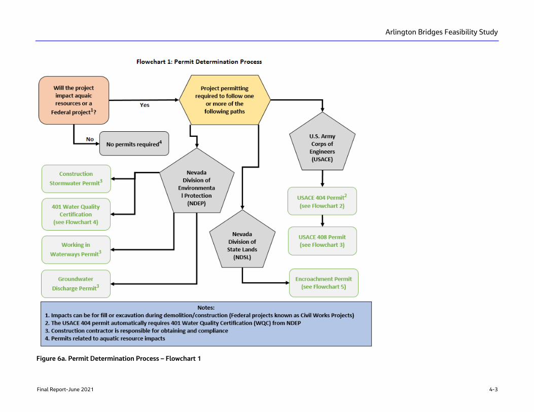
Arlington Bridges Feasibility Study
Final Report-June 2021 4-3
Figure 6a. Permit Determination Process – Flowchart 1
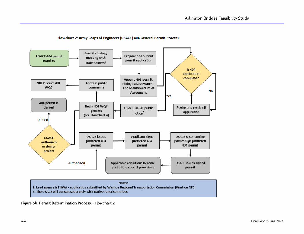
Arlington Bridges Feasibility Study
4-4 Final Report-June 2021
Figure 6b. Permit Determination Process – Flowchart 2
Arlington Bridges Feasibility Study
Final Report-June 2021 4-5
Figure 6c. Permit Determination Process – Flowchart 3
Arlington Bridges Feasibility Study
4-6 Final Report-June 2021
Figure 6d. Permit Determination Process – Flowchart 4
Arlington Bridges Feasibility Study
Final Report-June 2021 4-7
Figure 6e. Permit Determination Process – Flowchart 5

Arlington Bridges Feasibility Study
Final Report-June 2021 5-1
5. Outreach Conducted for this Study
5.1 Overview
Stakeholder workshops and public outreach held during the feasibility study phase included updates and
information sharing with key stakeholders, elected officials, and the general public. Key stakeholder
meetings included focus groups such as the City of Reno, RTC TAC, RTC CMAC, USACE, CTWCD, FHWA,
TRFMA, utilities, and adjacent property owners. Information presented and comments received at the
SWG, TAC, and public meetings are summarized in Appendix E.
5.2 Key Findings
Informational workshops with agencies, stakeholder working group, and technical advisory committees
were held to present, evaluate, discuss, and receive comments on the conceptual bridge alternatives,
bridge type-specific environmental requirements, and preliminary aesthetic themes. Table 7 summarizes
these meetings.
During the February 24, 2021 Reno City Council Meeting the question was raised if large-scale
improvements to Wingfield Park could be included with the Arlington Avenue Bridge Project. Appendix G
contains a letter Reno City Council from the RTC stating that any park improvements should proceed
under their own scope of work and managed by the City of Reno.
Table 7. Informational Workshops
Stakeholder Meeting Date Notes and Key Takeaways
TRFMA March 6, 2019 Not part of flood project; 100-year water surface elevation (4,502 feet
above mean sea level); debris removal beneath bridge important;
provide hydraulic modeling to guide design.
FHWA/NDOT March 25, 2019 Bridges not historic; programmatic agreement with the Nevada State
Historic Preservation Office not required; Section 408 permit required;
use NDOT PEL Checklist.
USACE April 23, 2019 Involvement with Section 404 and 408 permits; USACE will consult
separately with tribes under Section 106.
RTC Board May 20, 2019 Presented Project’s Purpose and Need; reviewed project scope, process,
and approach.
Reno City
Council
November 13, 2019 Bridge replacement included in 2040 RTP; agreed with public
participation approach and process; confirmed stakeholder list and
process.
RTC TAC December 4, 2019 Provide update on the Arlington Avenue Feasibility Study. Defined
process, stakeholder working group members, and notification of Public
kick-off meeting.
SWG Meeting 1 February 6, 2020 Summarized project background; introduced federal agency roles and
responsibilities; developed engineering and environmental design
constraints and criteria.
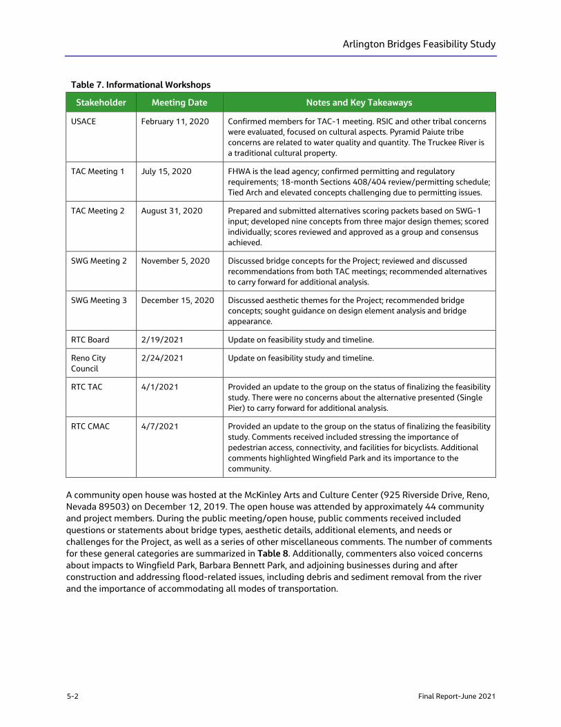
Arlington Bridges Feasibility Study
5-2 Final Report-June 2021
Table 7. Informational Workshops
Stakeholder Meeting Date Notes and Key Takeaways
USACE February 11, 2020 Confirmed members for TAC-1 meeting. RSIC and other tribal concerns
were evaluated, focused on cultural aspects. Pyramid Paiute tribe
concerns are related to water quality and quantity. The Truckee River is
a traditional cultural property.
TAC Meeting 1 July 15, 2020 FHWA is the lead agency; confirmed permitting and regulatory
requirements; 18-month Sections 408/404 review/permitting schedule;
Tied Arch and elevated concepts challenging due to permitting issues.
TAC Meeting 2 August 31, 2020 Prepared and submitted alternatives scoring packets based on SWG-1
input; developed nine concepts from three major design themes; scored
individually; scores reviewed and approved as a group and consensus
achieved.
SWG Meeting 2 November 5, 2020 Discussed bridge concepts for the Project; reviewed and discussed
recommendations from both TAC meetings; recommended alternatives
to carry forward for additional analysis.
SWG Meeting 3 December 15, 2020 Discussed aesthetic themes for the Project; recommended bridge
concepts; sought guidance on design element analysis and bridge
appearance.
RTC Board 2/19/2021 Update on feasibility study and timeline.
Reno City
Council
2/24/2021 Update on feasibility study and timeline.
RTC TAC 4/1/2021 Provided an update to the group on the status of finalizing the feasibility
study. There were no concerns about the alternative presented (Single
Pier) to carry forward for additional analysis.
RTC CMAC 4/7/2021 Provided an update to the group on the status of finalizing the feasibility
study. Comments received included stressing the importance of
pedestrian access, connectivity, and facilities for bicyclists. Additional
comments highlighted Wingfield Park and its importance to the
community.
A community open house was hosted at the McKinley Arts and Culture Center (925 Riverside Drive, Reno,
Nevada 89503) on December 12, 2019. The open house was attended by approximately 44 community
and project members. During the public meeting/open house, public comments received included
questions or statements about bridge types, aesthetic details, additional elements, and needs or
challenges for the Project, as well as a series of other miscellaneous comments. The number of comments
for these general categories are summarized in Table 8. Additionally, commenters also voiced concerns
about impacts to Wingfield Park, Barbara Bennett Park, and adjoining businesses during and after
construction and addressing flood-related issues, including debris and sediment removal from the river
and the importance of accommodating all modes of transportation.

Arlington Bridges Feasibility Study
Final Report-June 2021 5-3
Table 8. Summary of Public Meeting Comments From December 12, 2019 Open House
Category Sub-Category
Number of
Comments Notes
Bridge Type Elevated 10 In favor (4) and opposed (6)
Clear Span 5 In favor (4) and opposed (1)
Other 12 Function first, not cookie cutter
Aesthetic Details 14 Artistic, unique, tie into park setting
Other Additional Elements 13 Consider growth, traffic, cost, pedestrian friendly, park
access
Needs/Challenges 17
Miscellaneous 7 Growth, emergency vehicles, river/park access,
demolition and construction impacts,
Total 78
Comments received from agencies supported and reinforced the public’s input on incorporating multi-
modal design elements, ensuring access to the river and park for maintenance, and facilitating
debris/sediment removal from the river. The bridge cross-sections described above are intended to
address these concerns. Additional input focused on balancing the bridge’s architectural features with
funding constraints; the need to consider traffic performance metrics, such as LOS, pedestrian safety and
functionality; and the desire to be consistent with regional transportation planning and community goals
and objectives regarding the downtown streetscape.
Due to social distancing requirements resulting from the COVID-19 pandemic, the second public meeting
was a pre-recorded presentation posted on the RTC’s website in March 2021 and is still available for
viewing at https://youtu.be/yAKUvzU8e0c . An accompanying survey was available for 30 days during
March 2021. To inform the public where to access the presentation and accompanying survey, postcard
flyers were mailed to the surrounding public and stakeholders, and an email sent to the project specific
email list. In addition, the RTC promoted the presentation on their social media websites, and the local
news channels.
In total, there were 353 survey responses and 16 individual public comments. A complete list of survey
results and comments may be found in Appendix E7.
Three specific survey questions that show a majority are in favor of the single pier alternative for the north
bridge and support of the proposed Art Deco aesthetic theme are:
Question: Do you agree with eliminating the Underdeck Arch, Tied Arch, and Elevated Bridge Alternatives?
Response: 75.8% Yes 12.5% Unsure 11.7% No
Question: Do you agree with RTC’s recommendation of the Single Pier Bridge (for the north bridge)?
Response: 65.6% Yes 28.7% No 5.7% Unsure
Question: Do you agree with the Art Deco aesthetic theme to meld old and new?
Response: 82.0% Yes 10.7% Indifferent 7.3% No
Arlington Bridges Feasibility Study
5-4 Final Report-June 2021
In support of the public, stakeholder, and agency comments received at the various workshops, the NDOT
PEL Questionnaire and Checklist were completed to document the linkage between planning and potential
environmental concerns, and to inform the NEPA process. Following the PEL process can assist with
identifying issues, and it supports agency, stakeholder, and public understanding of the Project’s scope,
purpose and need, as well as engineering/environmental constraints and criteria. The completed PEL
Questionnaire and Checklist is provided in Attachment A. As indicated in NDOT’s November 2012
guidance, the PEL Questionnaire and Checklist support the PEL process and serves the following dual
objectives:
▪ Provide guidance to transportation planners on the level of detail needed to ensure that information
collected, and decisions made during the transportation planning study can be used during the NEPA
process for a proposed transportation project.
▪ Provide the future NEPA study team with documentation on the outcomes of the transportation
planning process, including the history of decisions made and the level of detailed analysis
undertaken.
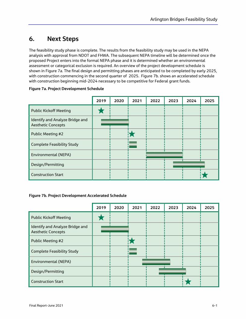
Arlington Bridges Feasibility Study
Final Report-June 2021 6-1
6. Next Steps
The feasibility study phase is complete. The results from the feasibility study may be used in the NEPA
analysis with approval from NDOT and FHWA. The subsequent NEPA timeline will be determined once the
proposed Project enters into the formal NEPA phase and it is determined whether an environmental
assessment or categorical exclusion is required. An overview of the project development schedule is
shown in Figure 7a. The final design and permitting phases are anticipated to be completed by early 2025,
with construction commencing in the second quarter of 2025. Figure 7b. shows an accelerated schedule
with construction beginning mid-2024 necessary to be competitive for Federal grant funds.
Figure 7a. Project Development Schedule
Figure 7b. Project Development Accelerated Schedule
2019 2020 2021 2022 2023 2024 2025
Public Kickoff Meeting
Identify and Analyze Bridge and
Aesthetic Concepts
Public Meeting #2
Complete Feasibility Study
Environmental (NEPA)
Design/Permitting
Construction Start
2019 2020 2021 2022 2023 2024 2025
Public Kickoff Meeting
Identify and Analyze Bridge and
Aesthetic Concepts
Public Meeting #2
Complete Feasibility Study
Environmental (NEPA)
Design/Permitting
Construction Start
Arlington Bridges Feasibility Study
6-2 Final Report-June 2021
6.1 Key Actions for Next Phase
To support an efficient and informed decision‐making process of the preferred bridge type, determination
of aesthetic design elements, and local connections, the subsequent project phases should include the
following:
▪ Close Coordination between transportation, planning, and environmental disciplines. Close
coordination with the USACE, CTWCD, City of Reno, and property owners/development interests
should include:
– A comprehensive traffic analysis to inform land use decisions and support the Project’s purpose
and need.
– A robust outreach process to include the continued SWG and TAC member involvement to ensure
affected property owner and key agency participation.
– Integration of flood protection requirements and coordination of preliminary design with CTWCD,
TRFMA, and City of Reno.
▪ Regulatory coordination to facilitate environmental approvals. Solidifying decision points and
agency input on remaining technical issues will be key to facilitating environmental approvals and
informing the next phase. These include:
– Confirmation of the Section 408 and 404 requirements established by USACE.
– Coordination with CTWCD on encroachment permits and mitigation of impacts.
– Proactive analysis of impacts, geotechnical, and hydraulics/scour issues to form a detailed project
description.
▪ Potential Design Additions. During the next phase of design and NEPA analysis, additional concepts
from stakeholders and agency input throughout the Feasibility Study process will be evaluated for
inclusion in the Project. These elements will require further design and environmental analysis to
determine if they meet the requirements. These additional concepts include:
• Wider sidewalks to accommodate the large number of pedestrians that visit Wingfield Park,
expecially during special events including the month long Artown performances and the Reno
River Festival.
• A path under the south bridge to reduce the number of at grade vehicle-pedistrain and
vehicle-bicycle conflicts.
• Narrowing the roadway by minimizing lane widths as appropriate while maintaining dedicated
bicycle lanes, transit stop locations, and dedicated left turn and right turn lanes.
• Maintenance access to the river to accommodate sediment and debris removal.
• Revised/Additional access to the Wingfield Park Amphitheater to create a more inviting
setting and increase usability especially during high predestrian-generating special events.
• Protection of park landscaping, minimizing the removal of mature trees
• Proposed pedestrian lighting to enhance saftey and create a more inviting setting
• Details of aesthetic elements including light fixtures,patterning and stain color of flood walls,
and other aesthietic features need to be determined and acceptable to stakeholders and
agencies, while protecting aquatic species.
• Constructabilty of the bridges, including dewatering approach, duration of construction, and
phasing of construction.
6.2 Anticipated National Environmental Policy Act Process
FHWA, in coordination with NDOT, will determine the future NEPA class of action for the Project. Based on
the Project’s potential for impacts as defined by NEPA, discussions with FHWA and NDOT environmental
Arlington Bridges Feasibility Study
Final Report-June 2021 6-3
staff, and considering the information provided in this report, it is not expected that an Environmental
Impact Statement (EIS) will be needed. Instead, this Project is expected to require an Environmental
Assessment (EA) or Categorical Exclusion (CatEx) for NEPA compliance. FHWA will be the lead federal
agency for the NEPA, NHPA, CWA, and emergency alert system compliance. Because this study took a PEL
approach, the environmental analysis was conducted at a planning level, based on existing mapping and
data resources. The future NEPA study will ensure the requirements for an EA are met, even if a CatEx is
determined for compliance, and will involve more detailed analyses for environmental resources that
could be impacted by the Project. The PEL checklist in Appendix A provides details on future
environmental analysis required or recommended.

Arlington Bridges Feasibility Study
Final Report-June 2021 7-1
7. References
City of Reno. 2009. TRAction Visioning Project Final Report. https://www.rtcwashoe.com/wp-
content/uploads/2019/12/TRActionVisioning_FinalReport_December20091.pdf. Prepared by
CH2M HILL. December.
City of Reno. 2017a. Downtown Action Plan. https://www.reno.gov/home/showdocument?id=70983.
Prepared by Progressive Urban Management Associates in association with Economic and Planning
Systems. April.
Regional Transportation Commission of Washoe County. 2018. 2040 Regional Transportation Plan,
Chapter 11. https://rtcwashoe.wpengine.com/wp-
content/uploads/2017/02/RTPBook_Dec20_2018_online_CH-11.pdf
City of Reno. 2019. Downtown Streetscape Design Manual.
https://www.reno.gov/home/showdocument?id=80640. March 18.
City of Reno. 2020. ReImagine Reno: The City of Reno Master Plan.
https://www.reno.gov/Home/ShowDocument?id=69070. December.
Nevada Land Trust (NLT) and Keep Truckee Meadows Beautiful (KTMB). 2016. One Truckee River
Management Plan, Phase 1 West McCarran to Sparks Boulevard. http://onetruckeeriver.org/wp-
content/uploads/2017/08/OTR-Management-Plan-2017.pdf. September.
Nevada Department of Transportation (NDOT). 2019. Planning and Environmental Linkages Questionnaire
and Checklist. https://www.nevadadot.com/home/showdocument?id=16135.