Embed Size (px)
Citation preview
JERRY L. CANFIELD, P.A.THOMAS A. DAILY, P.A.WYMAN R. WADE, JR., P.A.DOUGLAS M. CARSON, P.A.ROBERT R. BRIGGS, P.A. †C. MICHAEL DAILY, P.A. † !"L. MATTHEW DAVIS, P.A. †COLBY T. ROE
† Also Licensed in Oklahoma! Also Licensed in Wyoming & North Dakota" Certified Mediator
DAILY & WOODSA PROFESSIONAL LIMITED LIABILITY COMPANY
ATTORNEYS AT LAW
KMW BUILDING58 SOUTH SIXTH STREET
P.O. BOX 1446FORT SMITH, AR 72902
TELEPHONE (479) 782-0361FAX (479) 782-6160
______________
JAMES E. WESTDALE CARLTON
PHILLIP E. NORVELL †
OF COUNSEL_______
HARRY P. DAILY (1886-1965)JOHN P. WOODS (1886-1976)JOHN S. DAILY (1912-1987)
BEN CORE (1924-2007)
May 2, 2012
Arkansas Oil and Gas Commission301 Natural Resources Drive, Suite 102Little Rock, Arkansas 72205
Re: ORDER REFERENCE NO. 133-2012-05
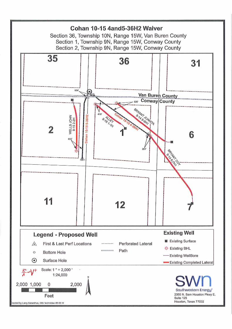
Application of SEECO, Inc. for an exceptional location pursuant to Arkansas Oiland Gas Commission General Rule B-43(i)(5) for its Cohan 10-15 #4-36H1 Welllocated in Section 36, Township 10 North, Range 15 West, Van Buren County,and Section 1, Township 9 North, Range 15 West, Conway County, Arkansas
Commissioners:
SEECO, Inc., 2350 N. Sam Houston Parkway E, Houston, TX 77032, hereby applies tothe Arkansas Oil and Gas Commission as follows:
1. The Applicant proposes the drilling and completion of a cross unit horizontal well,the Cohan 10-15 #4-36H1 (“Cohan #4”) Well located in Section 36, Township 10 North,Range 15 West, Van Buren County and Section 1, Township 9 North, Range 15 West,Conway County, Arkansas. The projected perforated lateral of the proposed Cohan10-15 #4 Well is expected to be 419 feet from the toe of the Alley 9-15 #1-1H (“Alley#1") Well, located in Section 1, Township 9 North, Range 15 West; 535 feet from thetoe of the Bryant, Juanita 9-14 #6H1 (“Bryant, Juanita #6") Well, located in Section 6and 1, Township 9 North, Range 15 West; and, 261 feet from the toe of the Bryant, Coy9-14 #6-7H1 (“Bryant, Coy #6") Well, located in Sections 7, 6 and 1, Township 9 North,Range 15 West. The Applicant requests that it be granted a location exception toenable it to produce the Cohan #4 Well notwithstanding such encroachments, providedthat the perforated wellbore of the Cohan #4 Well is no less than 240 feet from anyother wellbore.
2. The Applicant has solicited spacing waivers from most of the persons who havethe right to drill within Section 36, Township 10 North, Range 15 West and Sections 1, 6and 7, Township 9 North, Range 15 West, but has not yet obtained a waiver from everysuch owner.
3. The Applicant states that the granting of this application will be protective of thecorrelative rights of all interested parties and will prevent waste of natural gas by
permitting the most efficient method of developing the resource within thegovernmental sections which are the subject of this application.
4. The names and addresses of parties interested in this proceeding are set forth inExhibit "A" attached hereto and made a part hereof.
5. Please note the appearance of Thomas A. Daily of Daily & Woods, P.L.L.C.,P.O. Box 1446, Fort Smith, Arkansas, 72902, on behalf of applicant.
Very truly yours,
Thomas A. Dailyjmt

Cohan 10-15 #4-36H1
Section 1, T9N-R15WSection 2, T9N-R15W
Conway County, AR
Section 35, T10N-R15WSection 36, T10N-R15W
Van Buren County, AR
EXHIBIT “A”
SEECO, Inc.2350 N. Sam Houston Pkwy E., Suite 125Houston, TX 77032
BHP Billiton Petroleum (Fayetteville) LLC1360 Post Oak Blvd., Suite 150Houston, TX 77056-3030Attn: Fayetteville Shale Joint Interest Land
BP America Production Company501 Westlake Park Blvd.Houston, TX 77079
XTO Energy, Inc.810 Houston St.Fort Worth, TX 76102
XTO Energy, Inc.As Agent for ExxonMobil, Inc.810 Houston St.Fort Worth, TX 76102
Cade Oil & Gas, LLC11342 Birolli PlaceLittleton, CO 80125
Christopher R. F. EckelsP. O. Box 30Cedar Edge, CO 81413
Western Interior Energy, Inc.P. O. Box 247Crested Butte, CO 81224
The Robert & Maxine Hannifin TrustP. O. Box 218Midland, TX 79702Attn: Robert H. Hannifin
The New Mexico CompanyP. O. Box 2479Midland, TX 79702
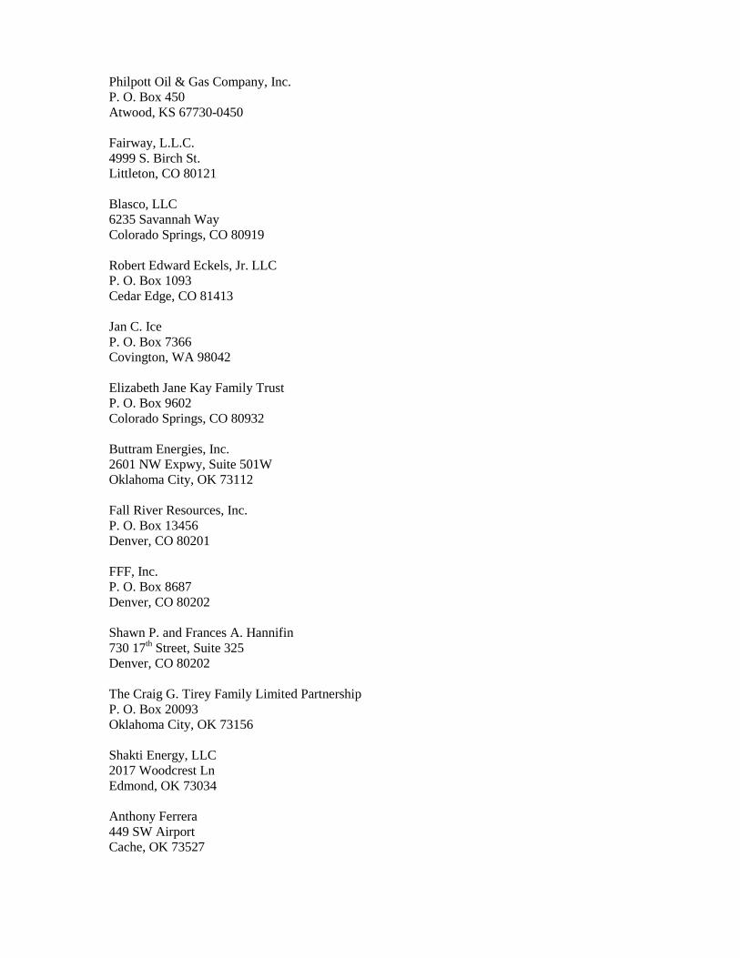
Philpott Oil & Gas Company, Inc.P. O. Box 450Atwood, KS 67730-0450
Fairway, L.L.C.4999 S. Birch St.Littleton, CO 80121
Blasco, LLC6235 Savannah WayColorado Springs, CO 80919
Robert Edward Eckels, Jr. LLCP. O. Box 1093Cedar Edge, CO 81413
Jan C. IceP. O. Box 7366Covington, WA 98042
Elizabeth Jane Kay Family TrustP. O. Box 9602Colorado Springs, CO 80932
Buttram Energies, Inc.2601 NW Expwy, Suite 501WOklahoma City, OK 73112
Fall River Resources, Inc.P. O. Box 13456Denver, CO 80201
FFF, Inc.P. O. Box 8687Denver, CO 80202
Shawn P. and Frances A. Hannifin730 17th Street, Suite 325Denver, CO 80202
The Craig G. Tirey Family Limited PartnershipP. O. Box 20093Oklahoma City, OK 73156
Shakti Energy, LLC2017 Woodcrest LnEdmond, OK 73034
Anthony Ferrera449 SW AirportCache, OK 73527

Shantanu Bhattacharya6128 Pepperbark Dr.Frisco, TX 75034
Martin L. & Cynthia S. Blair655 India St. #321San Diego, CA 92101
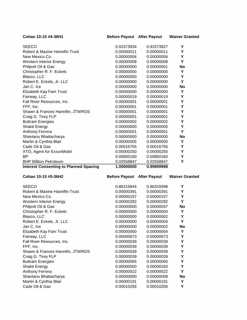
Cohan 10-15 #4-36H1 Before Payout After Payout Waiver Granted
SEECO 0.91573934 0.91573927 YRobert & Maxine Hannifin Trust 0.00000011 0.00000011 YNew Mexico Co. 0.00000004 0.00000004 YWestern Interior Energy 0.00000008 0.00000008 YPhilpott Oil & Gas 0.00000000 0.00000001 NoChristopher R. F. Eckels 0.00000000 0.00000000 YBlasco, LLC 0.00000000 0.00000000 YRobert E. Eckels, Jr. LLC 0.00000000 0.00000000 YJan C. Ice 0.00000000 0.00000000 NoElizabeth Kay Fam Trust 0.00000000 0.00000000 YFairway, LLC 0.00000019 0.00000019 YFall River Resources, Inc. 0.00000001 0.00000001 YFFF, Inc. 0.00000001 0.00000001 YShawn & Frances Hannifin, JTWROS 0.00000001 0.00000001 YCraig G. Tirey FLP 0.00000001 0.00000001 YButtram Energies 0.00000002 0.00000002 YShakti Energy 0.00000000 0.00000005 YAnthony Ferrera 0.00000001 0.00000001 YShantanu Bhattacharya 0.00000000 0.00000000 NoMartin & Cynthia Blair 0.00000005 0.00000005 YCade Oil & Gas 0.00016755 0.00016755 YXTO, Agent for ExxonMobil 0.05000250 0.05000250 YBP 0.00850160 0.00850160 YBHP Billiton Petroleum 0.02558847 0.02558847 YInterest Consenting to Planned Spacing 1.00000000 0.99999998
Cohan 10-15 #5-36H2 Before Payout After Payout Waiver Granted
SEECO 0.86315844 0.86315598 YRobert & Maxine Hannifin Trust 0.00000391 0.00000391 YNew Mexico Co. 0.00000157 0.00000157 YWestern Interior Energy 0.00000282 0.00000282 YPhilpott Oil & Gas 0.00000000 0.00000047 NoChristopher R. F. Eckels 0.00000000 0.00000004 YBlasco, LLC 0.00000000 0.00000002 YRobert E. Eckels, Jr. LLC 0.00000000 0.00000004 YJan C. Ice 0.00000000 0.00000002 NoElizabeth Kay Fam Trust 0.00000000 0.00000004 YFairway, LLC 0.00000673 0.00000673 YFall River Resources, Inc. 0.00000039 0.00000039 YFFF, Inc. 0.00000039 0.00000039 YShawn & Frances Hannifin, JTWROS 0.00000039 0.00000039 YCraig G. Tirey FLP 0.00000039 0.00000039 YButtram Energies 0.00000065 0.00000065 YShakti Energy 0.00000000 0.00000183 YAnthony Ferrera 0.00000022 0.00000022 YShantanu Bhattacharya 0.00000000 0.00000009 NoMartin & Cynthia Blair 0.00000191 0.00000191 YCade Oil & Gas 0.00010256 0.00010256 Y
XTO, Agent for ExxonMobil 0.01566214 0.01566214 YBP 0.02630117 0.02630115 YBHP Billiton Petroleum 0.09475632 0.09475626 YInterest Consenting to Planned Spacing 1.00000000 0.99999943
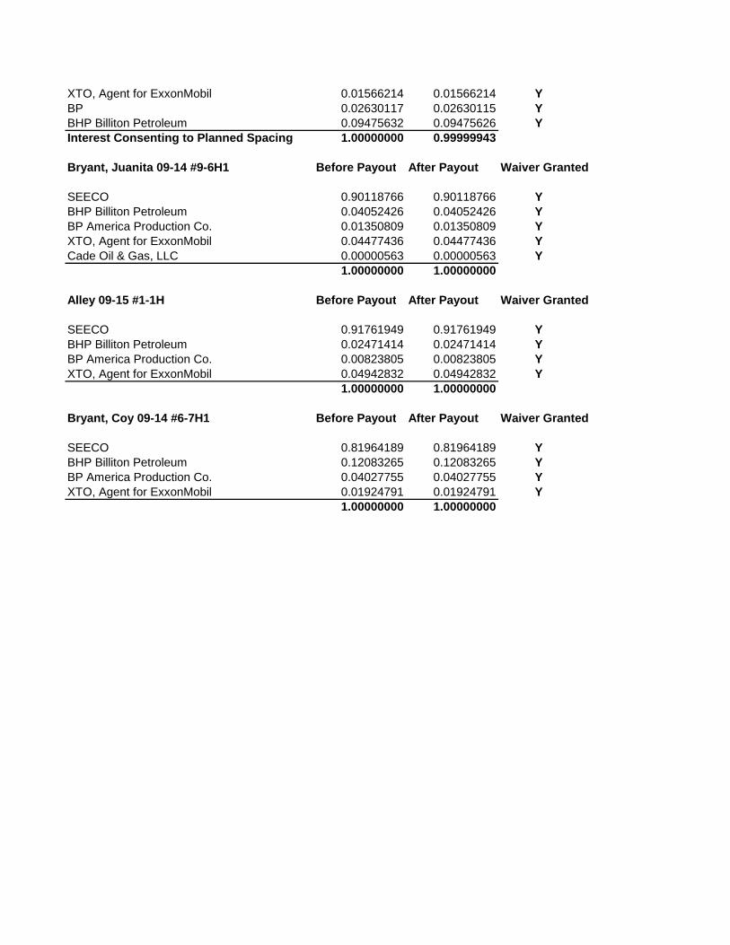
Bryant, Juanita 09-14 #9-6H1 Before Payout After Payout Waiver Granted
SEECO 0.90118766 0.90118766 YBHP Billiton Petroleum 0.04052426 0.04052426 YBP America Production Co. 0.01350809 0.01350809 YXTO, Agent for ExxonMobil 0.04477436 0.04477436 YCade Oil & Gas, LLC 0.00000563 0.00000563 Y
1.00000000 1.00000000
Alley 09-15 #1-1H Before Payout After Payout Waiver Granted
SEECO 0.91761949 0.91761949 YBHP Billiton Petroleum 0.02471414 0.02471414 YBP America Production Co. 0.00823805 0.00823805 YXTO, Agent for ExxonMobil 0.04942832 0.04942832 Y
1.00000000 1.00000000
Bryant, Coy 09-14 #6-7H1 Before Payout After Payout Waiver Granted
SEECO 0.81964189 0.81964189 YBHP Billiton Petroleum 0.12083265 0.12083265 YBP America Production Co. 0.04027755 0.04027755 YXTO, Agent for ExxonMobil 0.01924791 0.01924791 Y
1.00000000 1.00000000
ALLEY 09-15 #1-01H
ALLEY 09-15 #2-01H
ALLEY 09-15 #3-01H06
ALLEY 09-15 #4-01H06-ST1
ALLEY 09-15 #5-01H06
ALLEY 09-15 #6-01H06
BOWMAN 09-14 A RD A #1-08H05
BOWMAN 09-14 A RD A #10-08H
BOWMAN 09-14 A RD A #11-08H
BOWMAN 09-14 A RD A #12-08H
BOWMAN 09-14 A RD A #2-08H
BOWMAN 09-14 A RD A #9-08H05
BOWMAN 09-14 A RD C #7-05H
BOWMAN 09-14 A RD J #4-08H
BRYANT, COY 09-14 #1-07H-ST1
BRYANT, COY 09-14 #2-07PH-ST1
BRYANT, COY 09-14 #5-07H01
BRYANT, COY 09-14 #6-07H01
BRYANT, JUANITA 09-14 #1-06H
BRYANT, JUANITA 09-14 #2-06H
BRYANT, JUANITA 09-14 #3-06H31
BRYANT, JUANITA 09-14 #4-06H31
BRYANT, JUANITA 09-14 #5-06H07
BRYANT, JUANITA 09-14 #6-06H07
BRYANT, JUANITA 09-14 #7-06H07
BRYANT-KORDSMEIER 09-14 #1-17H
COHAN 10-15 #1-36H
COHAN 10-15 #2-36H35
COHAN 10-15 #3-36H-ST1
CROW 10-15 #7-28H27
CROW, RANDALL 10-15 #4-27H34
CROW, RANDALL 10-15 #5-27H35
DIXON 10-15 #1-35H
GRAVES 10-15 #3-26H-ST1GRAVES 10-15 #5-26H
GRAVES 10-15 #6-26H
NOLEN 09-14 A RD B #1-05H
NOLEN 09-14 A RD B #2-05H08
NOLEN 09-14 A RD B #3-05H
NOLEN 09-14 A RD B #4-05H
PETERSON 09-15 #1-12H
PETERSON 09-15 #2-12H
PETERSON 09-15 #3-12H01-ST1
REEVES, CHARLES 09-15 #2-10H
REEVES, CHARLES 09-15 #3-10H3REEVES, CHARLES 09-15 #4-10H3-ST1
REEVES, CHARLES 09-15 #5-10H3
REEVES, CHARLES 09-15 #6-10H
SHIP, DON 09-15 #1-11H
SHIP, DON 09-15 #2-11H
STARK, GARY 09-15 #1-14H
STARK, GARY 09-15 #10-14H
STARK, GARY 09-15 #11-14H15
STARK, GARY 09-15 #4-14H
WARD 10-14 #1-31H
WARD 10-14 #2-31H
WARD 10-14 #3-31H06
WARD 10-14 #4-31H06
WARD 10-14 #5-31H06
WARD-BOWMAN 09-14 A RD E #1-08H05
WELLS 09-15 #1-02H11
WELLS, JOHN 09-15 #1-02H
WELLS, JOHN 09-15 #2-02H
WELLS, JOHN 09-15 #3-02H
WELLS, JOHN 09-15 #4-02H35
WELLS, JOHN 09-15 #5-02H35
WILLIAMS, KENNETH 10-15 #1-25H
WILLIAMS, KENNETH 10-15 #3-25H
WOOLVERTON 09-15 #1-11PH-ST1
WOOLVERTON 09-15 #2-11H-ST1
WOOLVERTON 09-15 #3-11H
WOOLVERTON 09-15 #4-11H
WOOLVERTON 09-15 #5-11H
2 6
7
1
1112
3135 36
12868700
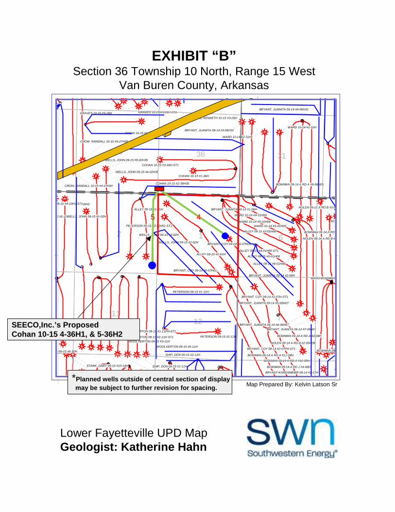
EXHIBIT “B”Section 36 Township 10 North, Range 15 West
Van Buren County, Arkansas
Lower Fayetteville UPD MapGeologist: Katherine Hahn
Map Prepared By: Kelvin Latson Sr
SEECO,Inc.’s ProposedCohan 10-15 4-36H1, & 5-36H2
*Planned wells outside of central section of display
may be subject to further revision for spacing.
45
-1
1
00
07
13
6
-
00
92
0
-
-2
-
80
0
30
0
0
00
27
-
ALLEY 09-15 #1-01H
ALLEY 09-15 #2-01H
ALLEY 09-15 #3-01H06
ALLEY 09-15 #4-01H06-ST1
ALLEY 09-15 #5-01H06
ALLEY 09-15 #6-01H06
BOWMAN 09-14 A RD A #1-08H05
BOWMAN 09-14 A RD A #10-08H
BOWMAN 09-14 A RD A #11-08H
BOWMAN 09-14 A RD A #12-08H
BOWMAN 09-14 A RD A #2-08H
BOWMAN 09-14 A RD A #9-08H05
BOWMAN 09-14 A RD C #7-05H
BOWMAN 09-14 A RD J #4-08H
BRYANT, COY 09-14 #1-07H-ST1
BRYANT, COY 09-14 #2-07PH-ST1
BRYANT, COY 09-14 #5-07H01
BRYANT, COY 09-14 #6-07H01
BRYANT, JUANITA 09-14 #1-06H
BRYANT, JUANITA 09-14 #2-06H
BRYANT, JUANITA 09-14 #3-06H31
BRYANT, JUANITA 09-14 #4-06H31
BRYANT, JUANITA 09-14 #5-06H07
BRYANT, JUANITA 09-14 #6-06H07
BRYANT, JUANITA 09-14 #7-06H07
BRYANT-KORDSMEIER 09-14 #1-17H
COHAN 10-15 #1-36HCOHAN 10-15 #2-36H35
COHAN 10-15 #3-36H-ST1
CROW 10-15 #7-28H27
CROW, RANDALL 10-15 #4-27H34
CROW, RANDALL 10-15 #5-27H35
DIXON 10-15 #1-35H
GRAVES 10-15 #3-26H-ST1GRAVES 10-15 #5-26H
GRAVES 10-15 #6-26H
NOLEN 09-14 A RD B #1-05H
NOLEN 09-14 A RD B #2-05H08
NOLEN 09-14 A RD B #3-05H
NOLEN 09-14 A RD B #4-05H
PETERSON 09-15 #1-12H
PETERSON 09-15 #2-12H
PETERSON 09-15 #3-12H01-ST1
REEVES, CHARLES 09-15 #2-10H
REEVES, CHARLES 09-15 #3-10H3REEVES, CHARLES 09-15 #4-10H3-ST1
REEVES, CHARLES 09-15 #5-10H3
REEVES, CHARLES 09-15 #6-10H
SHIP, DON 09-15 #1-11H
SHIP, DON 09-15 #2-11H
STARK, GARY 09-15 #10-14H
STARK, GARY 09-15 #11-14H15
STARK, GARY 09-15 #4-14H
WARD 10-14 #1-31H
WARD 10-14 #2-31H
WARD 10-14 #3-31H06
WARD 10-14 #4-31H06
WARD 10-14 #5-31H06
WARD-BOWMAN 09-14 A RD E #1-08H05
WELLS 09-15 #1-02H11
WELLS, JOHN 09-15 #1-02H
WELLS, JOHN 09-15 #2-02H
WELLS, JOHN 09-15 #3-02H
WELLS, JOHN 09-15 #4-02H35
WELLS, JOHN 09-15 #5-02H35
WILLIAMS, KENNETH 10-15 #1-25H
WILLIAMS, KENNETH 10-15 #3-25H
WOOLVERTON 09-15 #1-11PH-ST1
WOOLVERTON 09-15 #2-11H-ST1
WOOLVERTON 09-15 #3-11H
WOOLVERTON 09-15 #4-11H
WOOLVERTON 09-15 #5-11H
3135 36
2
1211
1
7
6
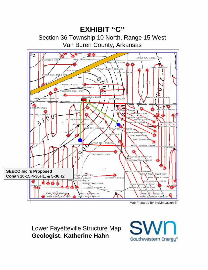
EXHIBIT “C”Section 36 Township 10 North, Range 15 West
Van Buren County, Arkansas
Lower Fayetteville Structure MapGeologist: Katherine Hahn
Map Prepared By: Kelvin Latson Sr
SEECO,Inc.’s ProposedCohan 10-15 4-36H1, & 5-36H2
45
820
082
27
0
ALLEY 09-15 #1-01H
ALLEY 09-15 #2-01H
ALLEY 09-15 #3-01H06
ALLEY 09-15 #4-01H06-ST1
ALLEY 09-15 #5-01H06
ALLEY 09-15 #6-01H06
BOWMAN 09-14 A RD A #1-08H05
BOWMAN 09-14 A RD A #10-08H
BOWMAN 09-14 A RD A #11-08H
BOWMAN 09-14 A RD A #12-08H
BOWMAN 09-14 A RD A #2-08H
BOWMAN 09-14 A RD A #9-08H05
BOWMAN 09-14 A RD C #7-05H
BOWMAN 09-14 A RD J #4-08H
BRYANT, COY 09-14 #1-07H-ST1
BRYANT, COY 09-14 #2-07PH-ST1
BRYANT, COY 09-14 #5-07H01
BRYANT, COY 09-14 #6-07H01
BRYANT, JUANITA 09-14 #1-06H
BRYANT, JUANITA 09-14 #2-06H
BRYANT, JUANITA 09-14 #3-06H31
BRYANT, JUANITA 09-14 #4-06H31
BRYANT, JUANITA 09-14 #5-06H07
BRYANT, JUANITA 09-14 #6-06H07
BRYANT, JUANITA 09-14 #7-06H07
BRYANT-KORDSMEIER 09-14 #1-17H
COHAN 10-15 #1-36HCOHAN 10-15 #2-36H35
COHAN 10-15 #3-36H-ST1
CROW 10-15 #7-28H27
CROW, RANDALL 10-15 #4-27H34
CROW, RANDALL 10-15 #5-27H35
DIXON 10-15 #1-35H
GRAVES 10-15 #3-26H-ST1GRAVES 10-15 #5-26H
NOLEN 09-14 A RD B #1-05H
NOLEN 09-14 A RD B #2-05H08
NOLEN 09-14 A RD B #3-05H
NOLEN 09-14 A RD B #4-05H
PETERSON 09-15 #1-12H
PETERSON 09-15 #2-12H
PETERSON 09-15 #3-12H01-ST1
REEVES, CHARLES 09-15 #2-10H
REEVES, CHARLES 09-15 #3-10H3
REEVES, CHARLES 09-15 #4-10H3-ST1
REEVES, CHARLES 09-15 #5-10H3
REEVES, CHARLES 09-15 #6-10H
SHIP, DON 09-15 #1-11H
SHIP, DON 09-15 #2-11H
STARK, GARY 09-15 #1-14H
STARK, GARY 09-15 #10-14H
STARK, GARY 09-15 #11-14H15
STARK, GARY 09-15 #4-14H
WARD 10-14 #1-31H
WARD 10-14 #2-31H
WARD 10-14 #3-31H06
WARD 10-14 #4-31H06
WARD 10-14 #5-31H06
WARD-BOWMAN 09-14 A RD E #1-08H05
WELLS 09-15 #1-02H11
WELLS, JOHN 09-15 #1-02H
WELLS, JOHN 09-15 #2-02H
WELLS, JOHN 09-15 #3-02H
WELLS, JOHN 09-15 #4-02H35
WELLS, JOHN 09-15 #5-02H35
WILLIAMS, KENNETH 10-15 #1-25H
WILLIAMS, KENNETH 10-15 #3-25H
WOOLVERTON 09-15 #1-11PH-ST1
WOOLVERTON 09-15 #2-11H-ST1
WOOLVERTON 09-15 #3-11H
WOOLVERTON 09-15 #4-11H
WOOLVERTON 09-15 #5-11H
3135 36
2
1211
1
7
6
12868700
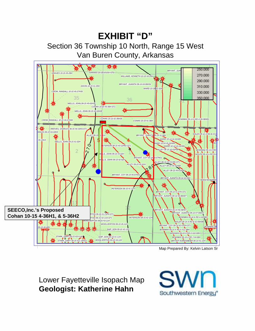
EXHIBIT “D”Section 36 Township 10 North, Range 15 West
Van Buren County, Arkansas
Lower Fayetteville Isopach MapGeologist: Katherine Hahn
Map Prepared By: Kelvin Latson Sr
SEECO,Inc.’s ProposedCohan 10-15 4-36H1, & 5-36H2
45