Embed Size (px)
Citation preview

González-León et al.292
Arizpesub-basin:AsedimentaryandvolcanicrecordofBasinandRangeextensioninnorth-centralSonora,Mexico
Carlos M. González-León1,*, Víctor A. Valencia2, Margarita López-Martínez3, Hervé Bellon4, Martín Valencia-Moreno1, and Thierry Calmus1
1 Estación Regional del Noroeste, Instituto de Geología, Universidad Nacional Autónoma de México, ApartadoPostal 1039, 83000 Hermosillo, Sonora, Mexico.
2 Geosciences Department, University of Arizona, Tucson, Arizona 85721, USA. 3 Departamento de Geología, Centro de Investigación Científica y de Educación Superior de Ensenada (CICESE),
Km 107 Carretera Ensenada-Tijuana No. 3918, 22860 Ensenada, Baja California, Mexico. 4 UMR 6538, Domaines Océaniques, IUEM, Université de Bretagne Occidentale,
6, Av. Le Gorgeu, Brest, 29285, France. * [email protected]
ABSTRACT
The Arizpe sub-basin located in the northern part of the Río Sonora basin is a Basin and Range half-graben that initiated during Late Oligocene time in north-central Sonora. Its ~2.1 km-thick, east-dipping volcanic and sedimentary fill assigned to the Báucarit Formation is divided, from base upwards, into the following informal members. The La Cieneguita member composed of interbedded conglomerate, siltstone and gypsum beds which unconformably overlay older Cenozoic volcanic rocks; the El Toro Muerto basalt composed of basalt flows, basalt breccia and subordinate conglomerate beds; the Arzipe conglomerate composed of three fining-upwards conglomerate sequences that interdigitates with flows of the Tierras Prietas basalt in its lower part and the Agua Caliente basalt in its upper part; the Bamori member is a coarsening-upward succession of siltstone, sandstone and conglomerate that unconformably overlies the Arizpe conglomerate and it is unconformably overlain by the sedimentary El Catalán breccia. Basin accommodation started at ~25 Ma when deposition of the La Cieneguita member, followed by alkaline basaltic volcanism of the El Toro Muerto and contemporaneous rhyolitic volcanism, floored the area predating significant clastic deposition. The Agua Caliente basalt (~21 Ma ) in the upper part of the basin fill indicates the basin was rapidly subsiding.
Multiple phases of normal faulting affected the Arizpe sub-basin. The main controlling structure may be the steep (80°), west-dipping, sub-parallel El Fuste and Granaditas normal faults that bound the Arizpe sub-basin at its present-day eastern margin, or there may be a fault or faults that were subsequently buried beneath younger basin fill near the eastern margin of the basin. The basin was disorganized by an even younger NW-SE phase of normal faulting represented by the southwest-dipping Crisanto and Tahuichopa faults. Growth strata within basin fill suggests that syntectonic deposition was active during all phases of normal faulting. However, punctuated tectonic activity on these faults may have controlled deposition of conglomerate sequences of the Arizpe conglomerate.
Geochemical data from the El Toro Muerto, the Tierras Prietas and the Agua Caliente basalt members indicate they are high-K, alkaline to subalkaline basaltic trachyandesites with light REE-enriched patterns, initial Sr ratios between 0.7069 and 0.7076, and εNd values between -3.76 and -4.88. Pb isotopic values from two samples of the El Toro Muerto basalt yielded very similar results, and along
Revista Mexicana de Ciencias Geológicas, v. 27, núm. 2, 2010, p. 292-312
González-León,C.M.,Valencia,V.A.,López-Martínez,M.,Bellon,H.,Valencia-Moreno,M.,Calmus,T.,2010,Arizpesub-basin:AsedimentaryandvolcanicrecordofBasinandRangeextensioninnorth-centralSonora,Mexico:RevistaMexicanadeCienciasGeológicas,v.27,núm.2,p.292-312.
Arizpe sub-basin: A sedimentary and volcanic record of Basin and Range extension 293
with the other geochemical data suggest an important participation of the continental lithosphere as magma source for this volcanism.
The data herein reported are supported by eight new geochronologic ages and they contribute to better document and constrain the timing of magmatism and extension in the Basin and Range tectonic province in Sonora.
Key words: magmatism, geochronology, Oligocene, Miocene, Basin and Range, Sonora, Mexico.
RESUMEN
La subcuenca de Arizpe, localizada en la parte norte de la cuenca del Río Sonora, es un medio graben que empezó a formarse durante el Oligoceno Tardío asociado a la deformación de Sierras y Valles Paralelos (Basin and Range). Su relleno volcánico y sedimentario de ~2.1 km de espesor, el cual buza hacia el oriente, se asigna a la Formación Báucarit y se divide, de la base a la cima, en los siguientes miembros informales. El miembro La Cieneguita, formado por conglomerado con intercalaciones de limolita y yeso, que sobreyace discordantemente a rocas volcánicas cenozoicas más antiguas; el basalto El Toro Muerto, formado por derrames de basalto, brecha basáltica y en menor proporción por conglomerado. El conglomerado Arizpe, formado por tres secuencias conglomeráticas grano decreciente hacia su cima y con interdigitaciones del basalto Tierras Prietas en su parte inferior y del basalto Agua Caliente en su parte superior. El miembro Bamori, formado por limolita, arenisca y conglomerado en secuencia grano-creciente hacia su cima, sobreyace en discordancia al conglomerado Arizpe y está a su vez sobreyacido discordantemente por la brecha El Catalán formada por clastos de basalto. La subcuenca Arizpe empezó a formarse hace ~25 Ma cuando la sedimentación terrígena del miembro La Cieneguita y el volcanismo alcalino del basalto El Toro Muerto precedieron a la sedimentación clástica del conglomerado Arizpe. La edad de ~21 Ma obtenida del basalto Agua Caliente, que ocurre en la parte superior del relleno de la cuenca, indica que ésta fue una cuenca de subsidencia rápida.
El fallamiento normal que inició a la cuenca tuvo lugar cerca de su actual margen oriental y controló el depósito de las secuencias conglomeráticas. En esa posición se ubican las fallas normales El Fuste y Granaditas que buzan al poniente, pero es probable que la falla principal se encuentre actualmente cubierta debajo de rocas más jóvenes del relleno de la cuenca. El fallamiento sinsedimentario fue importante y, después de su formación, la sub-cuenca Arizpe fue desorganizada por fallamiento normal de rumbo NW-SE representado por las fallas Crisanto y Tahuichopa.
Datos geoquímicos de los basaltos El Toro Muerto, Tierras Prietas y Agua Caliente indican que corresponden a traquiandesitas basálticas ricas en K, que varían de alcalinas a subalcalinas con un patrón de enriquecimiento en tierras raras ligeras, con relaciones isotópicas de Sr inicial entre 0.7069 y 0.7076 y valores iniciales de εNd entre -3.76 y -4.88. Análisis isotópicos de Pb en dos muestras del basalto El Toro Muerto arrojan valores muy parecidos y, en conjunto, estos datos sugieren una participación importante de la litósfera continental como fuente de los magmas de este volcanismo.
Los datos reportados se apoyan además en ocho nuevos fechamientos y contribuyen a documentar el tiempo del magmatismo y la extensión de la provincia tectónica de la Basin and Range en Sonora.
Palabras clave: magmatismo, tectónica, geocronología, Oligoceno, Mioceno, Basin and Range, Sonora, México.
INTRODUCTION
AlthoughmostofthestateofSonoraislocatedwithinthelateCenozoicsouthernBasinandRangeextensionalprovince and the sedimentary and volcanic fill of numer-ousNNW-SSE-orientedbasinsthatformedduringthistectoniceventarewellexposed,onlyafewstudieshavebeenconductedtounderstandtheirsedimentary,magmaticand tectonic history. King (1939) first noted that the fills of thesevalleysinsouthernSonoraaremostlycomposedofalowerbasalticmemberandanupperconglomeratememberthathenamedastheBáucaritFormationinoutcropsatthetownofBáucarit(Figure1).
Otherworkerssuggested thatnotallof the lateCenozoicextensionalbasinsinSonorasharesimilarsedi-mentaryandmagmatichistories(Gans,1997;McDowellet al.,1997)andapplieddifferentinformalnamestotheirfill deposits. The first attempts to understand the sedimen-taryhistoryofsomeofthesebasinswereconductedbyMiranda-GascaandDeJong(1992)andDelaO-Villanueva(1993),whostudiedtheMagdalenaandtheRíoYaquibasins(Figure1),respectively.OtherauthorsstudiedtheUresbasinincentralSonora(Calles-Montijo,1999;Vega-GranilloandCalmus,2003).McDowellet al.(1997)andGans(1997),however,studiedinmoredetailthemagma-tismandtectonicdevelopmentofthelateCenozoicbasins

González-León et al.294
114 00°32 00°
Sonoita A R I Z O N A
UresMazocahui
MoctezumaAconchi
Sierra SantaÚrsula
Guaymas-SanCarlos
BahíaKino
IslaTiburón
SantaRosa
PuertoLibertad
Sahuaripa
MbSanta Ana
CananeaNogales Agua
PrietaTb
Rsb
RybSb
31°
28°
108°111°
Ub
89
Yécora
Maycoba
Bb
Báucarit
S O N O R A
G U LF
OFC
AL
I FO R N I
A
HERMOSILLO
Area ofFigure 2
Sierra Libre
CaborcaArizpe
Rb
Bab
BA
J AC
AL I F
O R N I A
75 km
itsstratigraphicandstructuralrelationshipstobeeasilystudied.Ouraimistocontributetotheunderstandingofthesedimentaryandmagmatichistoryofatypical,com-plexly-deformedgrabenlocatedwithintheBasinandRangeprovinceofSonorabasedongeologicmapping,detailedmeasurementoftheentirebasinstratigraphicsection,andongeochronology,geochemicalandradiogenicisotopicanalyses of some of the interbedded volcanic flows.
GEOLOGIC SETTING
TheArizpesub-basinisaN-S-strikinghalf-grabenfilled by a Late Oligocene-Early Miocene, eastward thick-ening succession of interbedded mafic flows, subordinate ash-falltuffsandignimbrite,andclasticrocksthatGonzález-Leónet al. (2000) first assigned to the Arizpe conglomer-ate.ThebasinwasdevelopedoverabasementcomposedofstrataassignedtotheLowerCretaceousBisbeeGroupandtoUpperCretaceous-CenozoicvolcanicrocksoftheTarahumaraFormation(González-Leónet al.,2000)(Figure2). A rhyolitic unit with minor basalt flows that crops out
intheRíoYaquiregionandnearbyareasofsouthcentralSonora. Their results indicate that the fills of the Basin and Range basins are dominated by mafic flows in their lower partsandbyconglomerateintheirupperparts,andinmostcasesthenameBáucaritFormationwasappliedtodescribethatsuccession.
TheRíoSonorabasinisaninformalnamethatweapplytooneoftheseN-S-elongatedBasinandRangegra-benslocatedinthenorth-centralpartofSonora,betweenthetownsofArizpeandMazocahui(Figure1).Thisbasinis100km-longand15to25km-wide.OurresultsindicatethattheRíoSonorabasinisatectonicallyandsedimen-tologicallycomplexhalf-grabenthatislimitedtotheeastandwestbyelevatedmountainsrangescomposedofsedi-mentary,volcanicandplutonicrocks,whichrangeinagefromProterozoictoMiocene.Atitsnorthernandsouthernboundaries,theRíoSonorabasinisinfaultcontactwithhighmountainousranges.
Inthiswork,wepresentresultsforthenorthernmostpartoftheRíoSonorabasinlocatednearthetownofArizpe,whichwenametheArizpesub-basin.Thewell-exposedsedimentary and volcanic fill of this sub-basin allows for
Figure1.LocationmapoftheRíoSonorabasin,andotherBasinandRangeSonoranbasins,andlocalitiesmentionedinthiswork.Tb,Tubutamabasin;Mb,Magdalenabasin;Bb,Bacanuchibasin;Rsb,RíoSonorabasin;Ub,Uresbasin;Sb,Sahuaripabasin;Ryb,RíoYaquibasin;Rb,ElRodeobasin;Bab,Báucaritbasin.BlackrectangleindicatesthelocationoftheArizpesub-basinandofgeologicmapofFigure2;areaenclosedbydashedlineindicatesthelocationofSierraSantaÚrsulaandSierraLibre.

Arizpe sub-basin: A sedimentary and volcanic record of Basin and Range extension 295
Figure2.GeologicmapoftheArizpesub-basinintheRíoSonorabasin,andaccompanyingstructuralsectionsA-BandC-D.

González-León et al.296
CerroEl Picacho
1000
1500
1000
500
ArroyoTeguachi
CerrosPrietos Río Sonora
CerrosCumpas
1 km
Las HiguerasfaultInterstate 89
D
C
1000
1400 mRío Sonora
1 km
ArroyoEl ToroMuerto
Interstate89
Cerro SanMarcos
CañadaEl Catalán
El Fustefault
Granaditasfault
BA
El Toro Muerto basalt
Arizpe conglomerate
Tierras Prietas basalt
Tarahumara Formation
Agua Caliente basalt
El Catalán breccia
Sinoquipe conglomerateCerro El Picachotrachydacite
Bamori member
Alluviun
Bamori member
Agua Caliente basalt
Tierras Prietas basalt
El Toro Muerto basalt Tarahumara Formation
Bisbee Group
Sinoquipe conglomerate
El Catalán breccia
La Cieneguita member
Tetuachi ignimbrite
Báu
carit
For
mat
ion
Ranch
Ariz
pe c
ongl
(Ac)
Cerro El Picacho trachydacite
Normal fault
CreekDated sample (showingsample number and age)
45 Strike and dip
89SON
Town
Interstate road
Qal
Scg
Gb
Cb
Bm
Acb
Tpb
Tmb
Cpt
Tfm
A
BLine of section
Tig
M a p e x p l a n a t i o n
Cerro Cebadehuachi volcanicrocks
Ccv
LcmLcm
intheeasternpartoftheareamightbecorrelativewiththeCerroCebadehuachivolcanicrocks,aunitofOligoceneagethatwasreportedfromitsoutcropsabout10kmnorthofthestudyarea(González-Leónet al.,2000).Basedonourmore detailed stratigraphic study, we divide the basin-fill successionintosevenmembers,restrictthetermArizpeconglomeratetooneofthemandreassignthewholesuc-cessiontotheBáucaritFormation.
Frombaseupwards,theBáucaritFormationiscom-posedofthefollowinginformalmembers:LaCieneguitamember,ElToroMuertobasalt,theArizpeconglomeratethat laterally interfingers with the Tierras Prietas and Agua Calientebasaltmembers,theBamorimemberandtheElCatalánbreccia(Figures2and3).
TheBáucaritFormationisexposedintheArizpeval-leybutinthisstudythecontinuousstratigraphicthickness
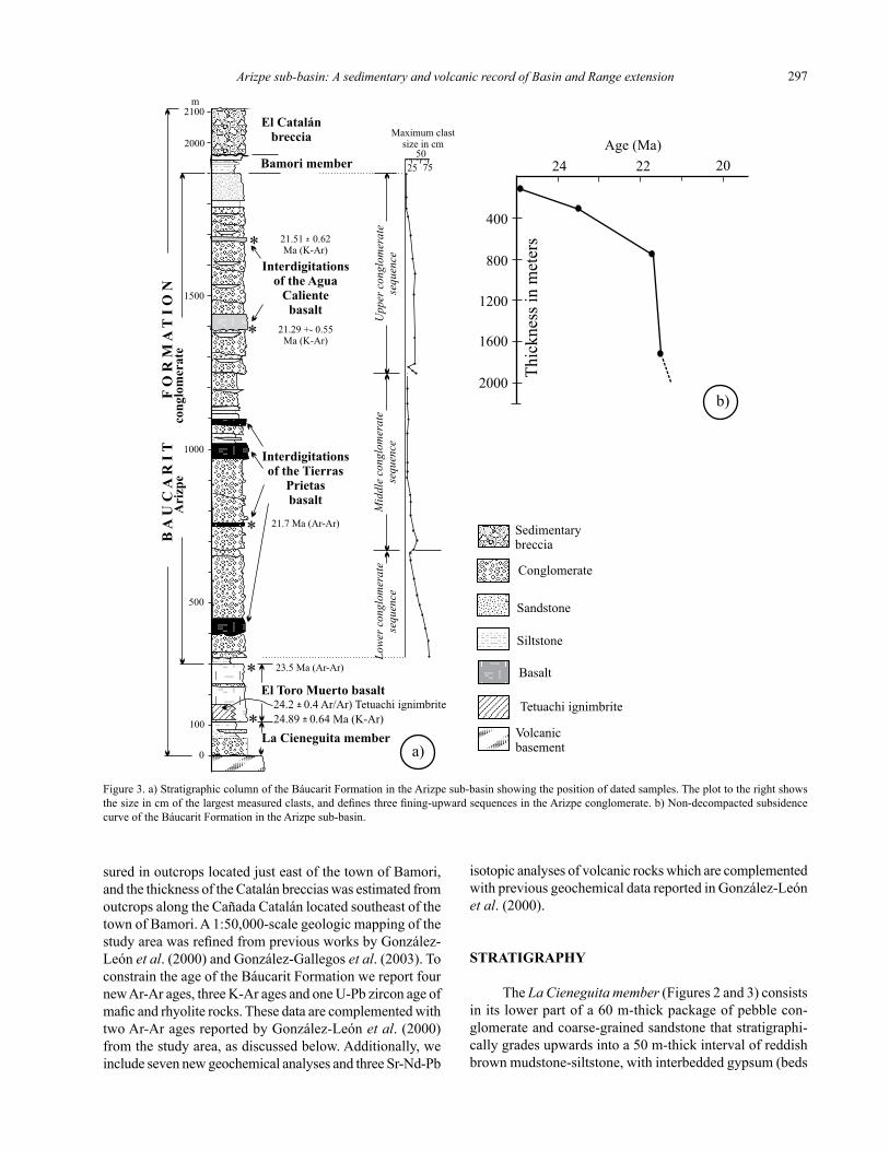
oftheLaCieneguitamember,ElToroMuertobasaltandtheArizpeconglomerateweremeasuredwithaJacob’sstaffalongtheElToroMuertocreek,betweenranchoLaCieneguitatothewestandthetownofBamoritotheeast(Figure2).TheuppermostpartoftheArizpeconglomeratewasmeasuredalongInterstateroad89fromtheArroyoAguaCalientetothetownofTahuichopa(Figure2).AlongtheElToroMuertosectiontheArizpeconglomerateinterdigitatesinitslowerpartwiththeTierrasPrietasbasalt,andinitsupperpartwiththeAguaCalientebasaltmembers(Figure3).ThethicknessoftheTierrasPrietasandAguaCalientebasaltswereestimatedfromtheirmorecompleteoutcropsalongthearroyoTetuachicreeklocatedabout6kmsouthoftheElToroMuertoCreekandalongthegorgecutbytheRíoSonorajustsouthofthetownofBamori,respectively(Figure2).ThethicknessoftheBamorimemberwasmea-
Figure2(continued).GeologicmapoftheArizpesub-basinintheRíoSonorabasin,andaccompanyingstructuralsectionsA-BandC-D.
Arizpe sub-basin: A sedimentary and volcanic record of Basin and Range extension 297
Interdigitationsof the Agua
Calientebasalt
El Catalánbreccia
Bamori member
2100
2000
1500
m
El Toro Muerto basalt
Ari
zpe
con
glom
erat
e
100
500
1000
0
24.89 0.64 Ma (K-Ar)±
23.5 Ma (Ar-Ar)
21.7 Ma (Ar-Ar)
Interdigitationsof the Tierras
Prietasbasalt
La Cieneguita member
BA
U C
AR
IT
FO
R M
AT
I O N
*
*
*
*
* 21.51 0.62Ma (K-Ar)
±
Sedimentarybreccia
Conglomerate
Sandstone
Siltstone
Volcanicbasement
Basalt
2550
75
Maximum clastsize in cm
Lowe
r con
glom
erat
ese
quen
ceM
iddl
e con
glom
erat
ese
quen
ceU
pper
cong
lom
erat
ese
quen
ce
21.29 +- 0.55Ma (K-Ar)
a)
24 2022
400
800
1200
1600
2000 Thic
knes
s in
met
ers
Age (Ma)
b)
24.2 0.4 Ar/Ar) Tetuachi ignimbrite± Tetuachi ignimbrite
suredinoutcropslocatedjusteastofthetownofBamori,andthethicknessoftheCatalánbrecciaswasestimatedfromoutcropsalongtheCañadaCatalánlocatedsoutheastofthetownofBamori.A1:50,000-scalegeologicmappingofthestudy area was refined from previous works by González-Leónet al.(2000)andGonzález-Gallegoset al.(2003).ToconstraintheageoftheBáucaritFormationwereportfournewAr-Arages,threeK-AragesandoneU-Pbzirconageofmafic and rhyolite rocks. These data are complemented with twoAr-AragesreportedbyGonzález-Leónet al.(2000)fromthestudyarea,asdiscussedbelow.Additionally,weincludesevennewgeochemicalanalysesandthreeSr-Nd-Pb
isotopicanalysesofvolcanicrockswhicharecomplementedwithpreviousgeochemicaldatareportedinGonzález-Leónet al.(2000).
STRATIGRAPHY
TheLa Cieneguita member (Figures2and3)consistsinitslowerpartofa60m-thickpackageofpebblecon-glomerateandcoarse-grainedsandstonethatstratigraphi-callygradesupwardsintoa50m-thickintervalofreddishbrownmudstone-siltstone,withinterbeddedgypsum(beds
Figure3.a)StratigraphiccolumnoftheBáucaritFormationintheArizpesub-basinshowingthepositionofdatedsamples.Theplottotherightshowsthe size in cm of the largest measured clasts, and defines three fining-upward sequences in the Arizpe conglomerate. b) Non-decompacted subsidence curveoftheBáucaritFormationintheArizpesub-basin.

González-León et al.298
< 5 cm thick) and granule to fine-grained sandstone (thin to mediumbeds).ThismemberunconformablyrestsonalteredvolcanicrocksassignedtotheTarahumaraFormationoronrhyolitictuffsofprobableOligoceneage(notdifferenti-atedinFigure2).TheLaCieneguitamemberisnotalwayspresentatthebaseoftheArizpeConglomerate,probablybecauseitwaspartlyerodedafterdepositionorbecauseitwasdepositedonanunevenerosionalsurface,andwherethisoccurs,theElToroMuertobasaltunconformablyrestsontheolderrocks.
TheEl Toro Muerto basalt sharplyoverliestheLaCieneguita member, and consists of basalt flows, basalt brecciaandsubordinateconglomeratebeds(Figures2and3). The basalt flows are fine-grained and petrographically classifyasporphyriticolivinebasaltwithphenocrystsofplagioclaseandscarceaugitepyroxeneinapseudotraquiticmatrixofmicroliticandesine(An34-50).Alocal,100m-thickoutcropofarhyoliticweldedtuffexposedthroughafaultcontactinthecentralpartoftheareaandthatweinformallynametheTetuachiignimbrite,isaprobableinterdigitationoftheTierrasPrietasbasalt,accordingtoitsgeochrono-logicage(Figure3).TheElToroMuertobasaltisinturnstratigraphicallyoverlainbytheArizpeconglomerate,buttowardthesouthwesternpartofthestudyareathesemem-bersareinterbedded(Figure2).Theestimatedthicknessofthismemberis200m.
ThestratigraphiccolumnoftheArizpe conglomerate is1,600m-thickalongthemeasuredsectionoftheElToroMuertocreek.ThelowermostpartoftheElToroMuertoconglomerateconsistsofa20m-thickintervalofmassive,greentolightgraysiltstone,whereastheremainderupperpartofthesuccessionispredominantlyconglomeratethatforms three fining-upward sequences distinguished on the basisoftheirmaximumclastsizes.Thesesequencesaredescribedbelowasthelower,middleandupperconglomer-atesequences(Figure3).
Thelowerconglomeratesequenceis340mthick(Figure3)andinitslowerpartconsistsofpoorly-sorted,pebbletocobbleconglomeratewithclasts(mostly<10cmlong)ofbasalt (~60%),andesite(~20%),rhyolite(~15%)andscarcediorite(Figure4a).Thelargestclastsarescatteredcobblesofbasaltupto80cm-long.Afewbedsofwhite,lithic-andcrystal-richash-falltuffsupto3mthick(Figure4b)areinterbeddedwithinthispartofthesection, along with a 50 m-thick flow of the Tierras Prietas basalt.Themiddleandupperpartsofthislowersequencemostlyconsistsofpoorlysorted,subangulartosubroundedpebble-conglomerateinbedsupto3mthick,buttheymorecommonlyoccurinbedslessthan60cmthick,becauseofabundantreactivationsurfaces.Theconglomeratebedsaremostlyclast-supportedandcommonlyhaveinterbedsofthin,lenticular,coarse-grainedtogranulesandstone,whichoccasionally show fining-upward cycles. Planar cross-strati-fication and large-scale trough cross-stratification are locally present.Intheupperpartofthissequence,thelargestclastsareofbasaltanddecreaseinsizeto20cm.
Themiddleconglomeratesequenceis590mthickandalsohasinterdigitationsoftheTierrasPrietasbasalt.Conglomeratebedsinthiscycleareupto3mthickbutabundantreactivationsurfaces(multistory)obliteratetheoriginal thicknesses of the fining-upward cycles. These bedsaremostlypebbleandrarelycobble,poorlysorted,subangularconglomeratewithlocal,poorly-developedpla-nar and trough cross-stratification. The largest clasts in this sequencearescatteredfragmentsofbasaltthatreachupto40cmlonginthelowerpartandareupto6cmlonginitsupperpart.Nearitsupperpart,thesequencehasintervalsup to 30 m thick of well stratified and well consolidated fine- to coarse-grained sandstone with interbedded yellow toreddish,bioturbatedsiltstoneandwhiteash-falltuffsbeds(Figure4c).Thesequenceendswitha110mthickpebbleconglomerate(clasts<5cmlong)withinterbedsofthin-tomedium-bedded, lenticular, fine- to coarse-grained sand-stone.Clastcompositionsinthissequenceareofandesite(~50%),basalt(~35%)andrhyolite(~15%).
Theupperconglomeratesequenceis650mthickandconsists of medium to thick, poorly defined beds of pebble conglomerate,sandypebbleconglomerate,pebblesandstoneandmorerarelycobbleconglomerateinbedsupto4mthick,withlenticularbedsofcoarse-tomedium-grainedsandstone.Bedscomposingfining-upwardsequencescanbepresent,buttheirupperpartsaregenerallycutbyabundantreactivationsurfaces.Theconglomerateismostlyclast-supported,butmatrix-supportedconglomeratealsooccur.Clastsarepoorlysorted,subroundedtosubangular,andconsistofandesite(~50%),rhyolite(~40%)andbasalt(~10%). Planar and trough cross stratification in bedsets up to 40 cm thick and crude horizontal stratification of clasts oc-casionallyoccurs.Thelargestclastsinthelowerpartofthissequenceareofbasaltandreachupto35cminlength.Theuppermost150mofthissequenceconsistsofpoorlysorted,clast-supported,subroundedpebbleconglomerate,witharichmatrixofpebbletogranulesandstonethatinterbedswith fine- to coarse-grained, lenticular sandstone. These lithologiesgradetothetopofthesequencetowell-strati-fied granule and coarse-grained sandstone. Reactivation surfacesareabundantintheupperpartofthesequence,whereassandstonebedsupto50cmthickaremorelaterallycontinuous.Maximumclastsizesinthispartofthesequencereaches10cminlengthandconsistofandesite(~50%),rhyolite(~30%),dacite(~10%)andbasalt(~10%).AtitsmiddleandupperpartsthissequencehasinterdigitationsoftheAguaCalientebasalt.
TheTierras Prietas basalt hasathicknessofabout700mestimatedfromoutcropsalongtheTetuachicreek,locatedsouthoftheElToroMuertocreek(Figure2).Thismemberconsists of superimposed 50 to 100 m-thick, fine-grained flows of basalt and basaltic breccias, which in their upper partsdevelopreddish,alteredintervalsupto20mthickofprobablypedogenicorigin(Figure4d).Petrographically,thisrockisaporphyriticolivinebasaltwithphenocrystsofplagioclase(An38-50)andsubordinateclinpyroxene(au-

Arizpe sub-basin: A sedimentary and volcanic record of Basin and Range extension 299
Figure4.OutcropphotographsoftheBáucaritFormationintheArizpesub-basin.a)Poorlysorted,pebbletocobbleconglomerateofthelowerpartoftheArizpeconglomeratemember,alongarroyoElToroMuerto.Outcropheightabout35m.b)Lithic-andcrystal-richash-falltuffsinterbeddedinthelowerpartoftheArizpeconglomeratemember.c)Fine-tocoarse-grainedsandstoneandinterbeddedyellowtoreddish,bioturbatedsiltstoneandwhiteash-falltuffsbedsintheupperpartofthemiddlesequenceoftheArizpeconglomeratemember.d)BasalticandbasalticbrecciaoftheTierrasPrietasbasaltdevelopingreddish,alteredintervalsofprobablypedogenicoriginattheirtops.OutcropatTetuachicreek.Heightofhillsinforegroundfrombaseofcreekis~60m.e)Unconformablecontact(yellowline)betweentheBamoriandtheElCatalánmembersintheRíoSonoraeastofthetownofBamori.ElFustefault(thick,dashedblackline)separatestheElCatalánbrecciafrominterbeddedrhyoliteandbasaltofsupposedOligoceneage.f)Outcropofthe crudely stratified El Catalán breccia dipping to the west in hills located just east of the town of Bamori (photograph viewing toward the southwest).

González-León et al.300
gite?),sortedinarichpseudotraquiticmatrixofmicroliticplagioclase.AlongtheElToroMuertomeasuredsection,flows of the Tierras Prietas basalt laterally interdigitate with thelowerandmiddleconglomeratesequencesoftheArizpeconglomerate(Figure3).
TheAgua Caliente basalt hasanestimatedthicknessof300minoutcropsalongtheRíoSonoragorge,justsouthofthetownofBamori(Figure2).TheAguaCalientebasaltconsists of poorly stratified, fine-grained mafic flows and breccia. The basalt flows display abundant calcite-filled cav-itiesandpetrographicallyshowanabundantpseudotraquiticmatrixofmicroliticplagioclasewithscarcephenocrystsofplagioclase(An39-53),olivineandclynopyroxene.
TheBamori member isa60m-thickclasticintervalthatunconformablyoverliestheupperconglomeratese-quenceinoutcropexposedeastoftheRíoSonora(Figure4e).Itformsathin,E-NEstripoutcropwithshallowdipstotheeast.Itisacoarsening-upwardsuccessionofmassive,bioturbated siltstone and fine grained sandstone in its lower part, and massive, fine-grained sandstone with intercalations ofmedium-bedded,coarse-grainedsandstoneincosetsup to 5 m thick that show fining-upward successions in itsmiddlepart.Theuppermost20mofthismembercon-
sistsofgranulesandstoneandlenticular,medium-beddedpebbleconglomeratethatarethelagsoflarge-scale,epsiloncross-stratification.
TheEl Catalán breccia hasanestimatedthicknessof150mandcropsoutintheeasternmarginoftheArizpebasin. It is a coarse, crudely stratified breccia with clasts up to2mlong(Figure4f).Theclastsareangularandpoorlysorted,andmostbedsarematrix-supported.Thematrixisamixtureofcoarsesandandgranuleswithoccasionalthintomedium,lenticularbedsofgranuleconglomerate.Theclastsaremostlyderivedfrombasalt(90%),buttherearealsoclastsofandesiteandrhyolite.ThismembershallowlydipstothewestandunconformablyoverliestheBamorimemberwhichdipstotheeast.
GEOCHRONOLOGY
AsamplefromthelowermostpartoftheElToroMuertobasaltyieldedaK-Arageat24.89±0.64Ma(sample6-3-05-1;Tables1and2,Figure2),similar(withinerror)toanAr-Ar(plateauage),sanidineageof24.2±0.4MaobtainedfromtheTetuachiignimbrite(sample10-10-
Unit Sample UTM Location Age
Tetuachiignimbrite 10-10-06-1 12R571932E;3345454N 24.2±0.2Ma(Ar/Ar)ElToroMuertobasalt(lowermostpart) 6-3-05-1 12R566338E;3356954N 24.89±0.64Ma(K/Ar,whole-rock)ElToroMuertobasalt 10-9-06-1 12R578845E;3348784N 23.3±0.3Ma(Ar/Ar)ElToroMuertobasalt 2-15-07-1 12R579239E;3345637N, 23.5±0.2Ma(Ar/Ar).ElToroMuerto(uppermostpart) A-101 12R571640E;3352300N 23.52±0.17Ma(Ar/Ar;González-Leónet al.,2000).CerroElPicacho 11-20-07-2 12R583523E;3334488N 23.3±0.6Ma(U/Pb)TierrasPrietasbasalt A-102D 12R573903E;3352512N 21.70±0.20Ma(Ar/Ar;González-Leónet al.,2000).AguaCalientebasalt 6-3-05-3 12R577704E;3354968N 21.29±0.55Maage(K/Ar,whole-rock).AguaCalientebasalt 6-3-05-2 12R579372E;3357108N 21.51±0.6Ma(K/Ar,whole-rock)ElPajaritobasalt 9-23-08-5 12R605576E;3321056N 18.6±0.2(Ar/Ar)
Table1.Summaryofgeochronologicagesofdatedsamplesfromthestudyarea,includingdatapreviouslyreportedbyGonzález-Leónet al.(2000).
1 2 3 4 5 6 7 8Sample
codeLocation Lab.Ref. Mean age
(Ma)Age(Ma)
± error (1 σ)
K2O(wt. %)
40Ar R
(10-7 cm3 g-1)40Ar R
(%)Molten weight
(g)
6-3-05-2 AguaCaliente B7204-1 21.51 21.31 ± 0.63 2.48 17.41 55.7 0.9871B6916-4 21.73 ± 0.61 2.48 17.49 70.9 0.8090
6-3-05-3 AguaCaliente B6944-4 21.29 ± 0.55 2.86 19.75 73.5 0.8195
6-3-05-1 ElTorroMuerto B6921-9 24.89 ± 0.64 1.99 16.08 79.1 0.8342
Column1:Laboratoryreference;BmeansBrestlaboratory,7204isthechronologicalorderofthisexperimentinthewholerangeofargonextractionsdoneinthelaboratory;-1istheorderofthisextractioninafullseriesofexperiments,i.e.,9to10samplesusingthesamemolybdenumcrucible,includ-ingatleastonestandardsampleofglauconiteGLO,foranoverallcalibrationandcontroltest.Column2:Themeanageresultsfromtwoindependentagedeterminations,i.e.,fortwodifferentargonextractionsfromrockgrainsundervacuumandtheirfurtherisotopicanalysesbymassspectrometry.Columns3and4:AgesarecalculatedwiththeconstantsrecommendedbySteigerandJäger(1977)anderrorsarequotedatonesigmalevelafterthecalculationsbyMahoodandDrake(1982).Column5:Kcontentsweremeasuredbyatomicabsorptionspectrometryafterachemicalattackat80°Cofa representative powder sample rock using hydrofluorhydric acid.
Table2.K-AragedataforthreesamplesoftheBáucaritFormationinthestudyarea.

Arizpe sub-basin: A sedimentary and volcanic record of Basin and Range extension 301
El Toro Muerto basalt
2
1
01.00.80.60.40.20
30
20
10
0
2-15-07-1 groundmass
El Toro Muerto basalt
1
01.00.80.60.40.20
30
20
10
0
10-9-06-1 groundmass
Tetuachi ignimbrite
0.05
01.00.80.60.40.20
30
20
10
0
10-10-06-1 sanidine
El Pajarito basalt
0.5
01.00.80.60.40.20
40
30
20
10
0
9-23-08-05 groundmass
Fraction of Ar released39 Fraction of Ar released39 Fraction of Ar released39 Fraction of Ar released39
3739
Ar
/ A
rCa
KA
ge in
Ma
t = 23.8 0.2 Mai +t = 22.7 0.4 Mai +
t = 22.4 0.3 Mai +t = 21.8 0.3 Mai + t = 24.0 0.2 Mai + t = 18.6 0.2 Map +
t = 23.5 0.2 Map + t = 23.3 0.3 Map +t = 24.2 0.2 Map +
t = 20.2 0.5 Mai +
t = 23.7 0.2 Ma( Ar / Ar) = 314 18
SumS / (n-2) = 1.2 , n = 10
c
i
++40 36
0.060.040.02
0.003air
0.002
0.001
00
1
23
45
6
7
1
23
45
6
7
39 40Ar/ Ar
3640
Ar/
Ar
0.060.040.02
0.003
0.002
0.001
00
airt = 23.1 0.4 Ma
( Ar / Ar) = 283 20SumS / (n-2) = 1.2 , n = 7
c
i
++40 36
1
2
345
6
1
2
3
45
39 40Ar/ Ar
3640
Ar/
Ar
0.060.040.02
0.003air
0.002
0.001
00
t = 24.1 0.2 Ma( Ar / Ar) = 313 68
SumS / (n-2) = 2.8 , n = 7
c
i
++40 361
23-9
39 40Ar/ Ar
3640
Ar/
Ar
0.100.060.02
0.003air
0.002
0.001
00
t = 18.8 0.3 Ma( Ar / Ar) = 219 19
SumS / (n-2) = 0.8 , n = 5
c
i
++40 36
2
1
8
3
4 76
5
39 40Ar/ Ar
3640
Ar/
Ar
a)
b)
c)
06-1;Figure5,Tables1and3,Appendix).Wealsodatedtwobasalticsamplesfromoutcropsinthesoutheasternpartofthearea,whichyieldedsimilarAr-Ar(plateau)agesat23.3±0.3and23.5±0.2Ma(samples10-9-06-1and2-15-07-1;Figure 5; Tables 1 and 3). These basalt flows underlie, and areinfaultcontactwiththeElCatalánbrecciaandtheAguaCalientebasalt(Figure2)andweinterpretthemtobelongtotheupperpartoftheElToroMuertobasaltonthebasisofasimilarageof23.52±0.17Ma(Ar-Ar,sampleA-101,Table1,Figure3)previouslyreportedbyGonzález-Leónet al.(2000)fromoutcropsofthatunitinthecentralpartofthestudyarea.González-Leónet al.(2000)alsoreporteda21.70 ± 0.20 Ma Ar-Ar age for a basalt flow from the middle partoftheTierrasPrietasbasalt(sampleA-102D,Table1,Figure3).Inthisstudy,weobtainedtwoK-AragesfromtwosamplesoftheAguaCalientebasalt.Thestratigraphi-callylowermostofthesesamplesyieldedanageof21.29±0.55Maage(samples6-3-05-3,Tables1and2),whilethestratigraphicallyuppermostoneyieldedanageof21.51±0.6(sample6-3-05-2,Tables1and2)(Figure3).
Furthermore,wehereinreportaU-Pbzirconageof23.3±0.6Ma(sample11-20-07-2,Tables1and4,Figure6)obtainedfromasampleofarhyolitedomeexposedatCerroElPicacho,locatedat11kmeastofthetownofSinoquipe(Figure2),whichiscontemporaneouswiththe
ElToroMuertobasaltandcouldrepresentthesourcefortheTetuachiignimbrite.Also,wereporta18.6±0.2MaAr-Ar,plateauage(sample9-23-08-5,Tables1and3,Figure5)for a mafic flow informally named the El Pajarito basalt, whichisinterbeddedintheupperpartoftheconglomeraticbasin fill of the El Rodeo basin located east of the Arizpe sub-basin(Figure1);thesedatahelptoconstrainyoungerageofBasinandRangedevelopmentinthisregion.
GEOCHEMISTRY AND ISOTOPIC RESULTS
Inanefforttocharacterizetheoriginandnatureofthesourceofthemagmasofthestudyarea,threesamplesfromtheElToroMuertobasaltandonesamplefromtheAguaCalientebasaltwereanalyzedformajorandtraceelementsandSr-Nd-Pbisotopiccompositions(Tables5and6;analyticalproceduresaredescribedintheAppendix).WealsoanalyzedmajorandtraceelementsfromonesampleoftheCerroElPicachodome,onesamplefromtheElPajaritobasaltandanotheronefromtheElHuarachebasalt(Table 5); this last mafic flows comes from the basal part of the El Rodeo basin fill and we tentatively assume it to be equivalent in age to the El Toro Muerto basalt. The mafic samplesfromtheArizpesub-basinplotmostlyasalkaline
Figure5.40Ar/39Arresults.Samples2-15-07-1and10-9-06-1oftheElToroMuertobasalt,and10-10-06-1oftheTetuachiignimbritearefromthestudyarea.Sample9-23-08-5isfromtheElPajaritobasaltintheElRodeobasin.Foreachsample:a)agespectrum;b)37ArCa/39Arkdiagram;c)36Ar/40Arversus39Ar/40Arcorrelationdiagram.

González-León et al.302
El Toro Muerto basalt 2-15-07-1 groundmass 1st experiment
pwr F39Ar 40Ar*/39ArK AgeinMa %40Ar* 40Ar/36Ar 37ArCa/39ArK tiinMa tpinMa tcinMa (40Ar/36Ar)i SumS/(n-2)/n
0.25 0.0229 -1.78±1.64 -9.8±9.0 † -2.82 287.40 1.340.50 0.0824 4.29±0.28 23.4±1.5 § 61.58 769.05 1.510.80 0.1403 4.45±0.13 24.3±0.7 § 94.01 4935.11 1.231.10 0.2194 4.26±0.08 23.3±0.5 § 90.49 3107.49 1.021.50 0.1966 4.32±0.07 23.6±0.4 § 96.18 7737.04 0.682.10 0.1970 4.29±0.11 23.4±0.6 § 94.67 5539.12 0.746.00 0.1413 4.19±0.19 22.9±1.0 § 78.02 1344.67 2.34 22.7±0.4 23.5±0.2
El Toro Muerto basalt 2-15-07-1 groundmass 2nd experiment
pwr F39Ar 40Ar*/39ArK AgeinMa %40Ar* 40Ar/36Ar 37ArCa/39ArK tiinMa tpinMa tcinMa (40Ar/36Ar)i SumS/(n-2)/n
0.26 0.0174 2.98±0.69 16.3±3.8 † 4.38 309.04 1.240.50 0.0583 4.28±0.12 23.4±0.7 † 33.56 444.78 1.510.80 0.1430 4.47±0.07 24.4±0.4 § 75.17 1189.89 1.381.10 0.2123 4.46±0.07 24.4±0.4 § 91.86 3628.75 1.081.50 0.2939 4.42±0.07 24.2±0.4 § 93.81 4773.23 0.702.10 0.1839 4.32±0.05 23.6±0.3 § 91.37 3424.58 0.796.00 0.0912 4.08±0.09 22.3±0.5 † 45.11 538.32 2.06 23.8±0.2 24.0±0.2 23.7 ± 0.2 ‡ 314±18 1.2/10
El Toro Muerto basalt 10-9-06-1 groundmass 1st experiment
pwr F39Ar 40Ar*/39ArK AgeinMa %40Ar* 40Ar/36Ar 37ArCa/39ArK tiinMa tpinMa tcinMa (40Ar/36Ar)i SumS/(n-2)/n
0.30 0.0331 1.39±0.90 7.6±5.0 † 3.40 305.90 0.570.60 0.1035 3.57±0.16 19.5±0.8 † 54.92 655.52 0.880.95 0.1458 4.10±0.11 22.4±0.6 § 85.57 2047.12 0.901.35 0.2022 4.14±0.08 22.6±0.4 § 88.25 2514.10 0.711.90 0.2807 4.21±0.08 23.0±0.4 § 82.29 1668.51 0.586.00 0.2347 4.08±0.09 22.3±0.5 § 67.02 895.92 1.56 21.8±0.3 22.6 ± 0.2
El Toro Muerto basalt 10-9-06-1 groundmass 2nd experiment
pwr F39Ar 40Ar*/39ArK AgeinMa %40Ar* 40Ar/36Ar37ArCa/39ArK tiinMa tpinMa tcinMa (40Ar/36Ar)i SumS/(n-2)/n
0.30 0.0310 1.83±0.68 10.0±3.7 † 7.32 318.85 0.480.60 0.0634 3.04±0.10 16.6±0.6 † 34.29 449.68 0.740.95 0.0896 4.10±0.08 22.4±0.4 80.25 1496.25 0.851.40 0.2501 4.24±0.07 23.2±0.4 § 89.69 2867.14 0.866.00 0.5659 4.27±0.07 23.4±0.4 § 78.14 1351.84 1.10 22.4±0.3 23.3±0.3 23.1±0.4‡ 283±20 1.2/7
Continues →
Table3.SummaryofAr/Ardataofsamplesfromthestudyarea.
basaltictrachyandesiteinthetotalalkaliesversussilica(TAS)diagram(LeBaset al.,1986),similartopreviousresultsobtainedfromthreesamplesoftheTierrasPrietasbasalt(samplesA-160,A-161ofGonzález-Leónet al.,2000) (Figure 7). The El Huarache and the El Pajarito mafic flows classify as trachybasalt and alkaline trachyandesite, respectively,andtheCerroElPicachodomeisasubalkalinetrachydacite(Figure7).TheREE-chondrite-normalized-patternsareveryconsistentforallthesesamples,showinganenrichmentinthelightREE,similartodatareportedfortheTierrasPrietasbasaltbyGonzález-Leónet al.(2000)(Figure8a),buttheCerroElPicachodisplaysanegativeEuanomaly(Figure8a).The87Sr/86SrisotopicratiosoftheElToroMuertoandAguaCalientebasaltsshowinitialvalues
between 0.7069 and 0.7076, coupled with negative εNd valuesbetween-3.8and-4.9(Figure8b).ThePbisotopicvaluesforthetwosamplesoftheElToroMuertobasaltshowconsistent208Pb/204Pbratiosbetween38.7and39,207Pb/204Pbratiosnear15.7,and206Pb/204Pbratiosbetween18.7and19(Figure8c).
SEDIMENTARY AND STRUCTURAL BASIN DEVELOPMENT
Onthebasisofitsregionallocationandage,andasindicatedbyitssedimentary,magmaticandstructuralrecord(discussedbelow),theArizpesub-basinisatypicalhalfgra-

Arizpe sub-basin: A sedimentary and volcanic record of Basin and Range extension 303
benthatdevelopedduringLateOligocene–EarlyMiocene(GeologicalSocietyofAmericaTimeScale,2009)regionalextensioninthesouthernBasinandRangeprovince.Amaximumageforbasininitiationisconstrainedto~25Ma(latestOligocene)bycontemporaneousbimodalvolcanismoftheElToroMuertobasaltandtheTetuachiignimbrite.TheLaCieneguitamemberandElToroMuertobasaltbothfloored the area prior to significant clastic deposition of the Arizpeconglomerate.TheyoungerdatedvolcanicrocksintheArizpesub-basinistheAguaCalientebasalt(~21Ma),which is interbedded in the upper part of the basin fill of theBáucaritFormation.Theseagesindicatethatthiswasarapidlysubsidingbasinasmostofitssedimentaryandvolcanicaccumulationoccurredinashortperiodoftime.
TheBáucaritFormationisa2.1km-thick,east-dip-ping,clasticandvolcanicsuccessionwhosetiltingmarkedlydecreases upsection from ~35º to 5-10º. The three fining-upward,multistoriedpebbleconglomeratesequencesoftheArizpeconglomerateareinterpretedtorepresentdepositsofbed-loaddominatedstreamsinproximalbraidedriversand/ormidalluvialfans.Thesandstoneandsiltstoneinter-valsintheupperpartsofthemiddleanduppersequencesindicatedepositionindistalbraidplainswithassociated
developmentoflacustrineenvironments.Thefactorscontrollingdepositionof large-scale
alluvial-fansequenceshavebeenattributedtoallocyclicforcessuchastectonicsandclimate.Weinterpretthatnormalfaultingthatinitiatedsubsidenceofthedownthrownblock was the primary control on deposition of the fining-upwardsequencesintheArizpeconglomerate,aswellasrelativeupliftoftheadjacentblocktotheeastthatfeddetritustothebasin.Thisinferenceisbasedonthethicknessof the succession, coarseness of the detritus, and unroofing ofthesourceareaasrecordedbyupwardenrichmentofvolcanicclastsintheArizpeconglomerate,derivedfromtheTarahumaraFormationbasement.Thenormalfaultingthatinitiatedthebasinformationandsubsequentbasindevelopmentoccurredclosetothepresenteasternmarginofthisbasin,asindicatedbyeastwardtiltingandinternalgrowthstratageometryofthesedimentaryfill.Inthisinterpretation(followingEinsele,1992),activephasesofnormalfaultingwereresponsiblefordepositionofeachof the conglomerate sequences whereas the fine-grained intervalsattheirtopsindicateperiodsoftectonicquiescencewhenretreatofthescarpfrontandloweringofreliefofthesourceareaoccurred.Basedonourgeochronology,it
Tetuachi ignimbrite 10-10-06-1 sanidine
pwr F39Ar 40Ar*/39ArK AgeinMa %40Ar* 40Ar/36Ar37ArCa/39ArK tiinMa tpinMa tcinMa (40Ar/36Ar)i SumS/(n-2)/n
0.88 0.0068 2.27±0.41 12.4±2.3 † 8.72 323.73 0.0392.00 0.0407 4.14±0.05 22.6±0.3 † 98.05 15136.48 0.0243.20 0.0576 4.30±0.04 23.5±0.2 96.13 7625.99 0.0164.50 0.0876 4.41±0.05 24.1±0.3 § 97.06 10052.72 0.0145.50 0.1415 4.43±0.04 24.2±0.2 § 98.69 22547.31 0.0126.50 0.0753 4.39±0.04 24.0±0.2 § 98.70 22721.53 0.0137.30 0.2813 4.45±0.02 24.3±0.1 § 95.67 6820.96 0.0127.50 0.1119 4.43±0.02 24.2±0.1 § 98.98 28989.58 0.0128.30 0.1974 4.46±0.05 24.4±0.3 § 98.01 14865.22 0.012 24.0±0.2 24.2±0.2 24.1 ± 0.2 322±69 2.8/9
El Pajarito basalt 9-23-08-05 groundmass
pwr F39Ar 40Ar*/39ArK AgeinMa %40Ar* 40Ar/36Ar37ArCa/39ArK tiinMa tpinMa tcinMa (40Ar/36Ar)i SumS/(n-2)/n
0.30 0.0064 46.0±2.7 244.8±13.2 † 70.50 1001.68 <0.0010.70 0.0432 4.23±1.07 24.0±6.0 † 24.61 391.97 0.4091.20 0.1337 2.87±0.15 16.3±0.9 59.48 729.31 0.6121.80 0.2196 3.21±0.06 18.2±0.4 § 90.81 3215.28 0.6562.20 0.1687 3.36±0.05 19.1±0.3 § 80.00 1168.58 0.5122.80 0.1486 3.34±0.05 18.9±0.3 § 77.78 1030.68 0.4334.00 0.1552 3.19±0.08 18.1±0.4 § 94.22 5112.95 0.4087.00 0.1246 3.55±0.07 20.1±0.4 † 99.65 84031.11 0.809 20.2±0.5 18.6 ± 0.2 18.8±0.3 219±19 0.8/5
Table3(continued).SummaryofAr/Ardataofsamplesfromthestudyarea.
pwr:laserpowerinwattsapplyiedtoreleaseargon;ageoftheindividualfractiondoesnotincludetheuncertaintyinJ;ti:integratedage;tp:plateauage;tc: isochron age calculated with all the fractions except those identified with the symbol †; (40Ar/36Ar)i:initial(40Ar/36Ar)calculatedfromtheinverseofthey-interceptoftheisochronlineinthecorrelationdiagram(36Ar/40Ar)versus(39Ar/40Ar); SumS /(n-2) goodness of fit of the best straight line calculated and numberofpointsused;§fractionsselectedforplateaucalculation;‡isochronagecalculatedcombiningthefractionsofthetwoexperimentsperformedon the sample; all errors are given at 1σ level; J for El Toro Muerto basalt and Tetuachi ignimbrite samples is 0.003048 ± 0.000017; El Pajarito basalt samplewasirradiatedseparately,J=0.003157±0.000050.ti,tpandtcincludetheuncertaintyinJ.Preferredageishighlightedinboldtypeface.

González-León et al.304
Isot
ope
ratio
sA
ppar
ent a
ges (
Ma)
Ana
lysi
sU
(ppm
)20
6 Pb/
204 P
bU
/Th
206 P
b*/
207 P
b*± (%
)20
7 Pb*
/23
5 U*
± (%)
206 P
b*23
8 U± (%
)er
ror
corr
.20
6 Pb*
/23
8 U*
±(M
a)20
7 Pb*
/23
5 U±
(Ma)
206 P
b*/
207 P
b*±
(Ma)
Bes
t age
(Ma)
±(M
a)
1120
072-
318
543
80.
715
.879
144
.20.
0327
44.6
0.00
385.
70.
1324
.21.
432
.714
.370
7.4
988.
524
.21.
411
2007
2-5
798
1746
0.6
20.2
824
12.7
0.02
5912
.80.
0038
1.5
0.12
24.5
0.4
26.0
3.3
162.
329
7.9
24.5
0.4
1120
072-
5A23
263
60.
816
.899
636
.50.
0298
36.9
0.00
365.
60.
1523
.51.
329
.810
.857
3.4
819.
923
.51.
311
2007
2-6
1374
3411
0.8
21.2
384
9.7
0.02
539.
80.
0039
1.0
0.10
25.0
0.2
25.3
2.4
53.5
232.
025
.00.
211
2007
2-9
219
612
0.5
15.2
488
37.4
0.03
5338
.00.
0039
7.0
0.18
25.1
1.8
35.2
13.2
792.
981
2.2
25.1
1.8
1120
072-
1020
080
40.
815
.728
937
.10.
0337
37.3
0.00
383.
80.
1024
.80.
933
.712
.472
7.6
813.
724
.80.
911
2007
2-11
180
549
0.6
25.2
560
71.2
0.01
9372
.60.
0035
13.9
0.19
22.8
3.2
19.4
14.0
NA
NA
22.8
3.2
1120
072-
1210
841
70.
834
.598
510
2.0
0.01
4310
2.1
0.00
365.
70.
0623
.11.
314
.414
.6N
AN
A23
.11.
311
2007
2-13
9442
60.
714
.251
992
.50.
0353
93.1
0.00
3611
.00.
1223
.42.
635
.232
.293
3.2
298.
323
.42.
611
2007
2-14
9833
30.
611
.712
915
2.4
0.04
1815
2.4
0.00
354.
00.
0322
.80.
941
.662
.113
24.1
402.
122
.80.
911
2007
2-15
202
714
0.6
16.8
684
57.2
0.03
0757
.30.
0038
3.5
0.06
24.2
0.9
30.7
17.4
577.
513
58.1
24.2
0.9
1120
072-
1636
966
90.
718
.251
431
.30.
0281
31.4
0.00
371.
80.
0623
.90.
428
.18.
740
3.7
717.
823
.90.
411
2007
2-17
327
615
0.9
14.5
870
28.4
0.03
3429
.10.
0035
6.6
0.23
22.7
1.5
33.3
9.6
885.
359
8.3
22.7
1.5
1120
072-
1924
453
10.
617
.418
036
.10.
0281
36.7
0.00
356.
20.
1722
.81.
428
.110
.250
7.4
819.
522
.81.
411
2007
2-20
480
582
0.6
15.6
926
15.4
0.03
3615
.50.
0038
1.7
0.11
24.6
0.4
33.6
5.1
732.
532
7.1
24.6
0.4
1120
072-
2132
960
60.
616
.524
024
.60.
0309
24.9
0.00
373.
50.
1423
.90.
830
.97.
662
2.1
539.
023
.90.
811
2007
2-22
302
435
0.5
15.6
758
37.2
0.03
4837
.40.
0040
4.4
0.12
25.5
1.1
34.8
12.8
734.
781
4.0
25.5
1.1
1120
072-
2349
466
00.
713
.100
529
.10.
0389
29.2
0.00
371.
00.
0323
.80.
238
.711
.111
03.8
595.
023
.80.
211
2007
2-24
306
516
0.5
15.7
717
23.0
0.03
3623
.10.
0038
2.2
0.10
24.7
0.5
33.6
7.6
721.
849
3.7
24.7
0.5
1120
072-
2522
232
70.
69.
8615
36.1
0.04
9936
.20.
0036
3.1
0.09
23.0
0.7
49.4
17.5
1650
.069
2.8
23.0
0.7
1120
072-
2613
565
70.
716
.776
752
.10.
0297
52.6
0.00
367.
40.
1423
.21.
729
.715
.458
9.3
1211
.723
.21.
711
2007
2-27
8343
80.
814
.096
515
4.0
0.03
6315
4.2
0.00
376.
70.
0423
.91.
636
.254
.995
5.7
692.
423
.91.
611
2007
2-28
222
2298
2.0
16.1
271
7.2
0.08
637.
30.
0101
1.1
0.15
64.7
0.7
84.0
5.9
674.
315
4.8
64.7
0.7
1120
072-
3130
376
20.
818
.025
120
.40.
0287
20.4
0.00
371.
20.
0624
.10.
328
.75.
843
1.5
459.
124
.10.
311
2007
2-32
466
948
0.5
17.1
558
16.9
0.02
9117
.10.
0036
2.4
0.14
23.3
0.5
29.1
4.9
540.
637
3.0
23.3
0.5
1120
072-
3362
281
30.
517
.198
110
.40.
0280
10.6
0.00
352.
20.
2022
.40.
528
.02.
953
5.2
227.
822
.40.
511
2007
2-34
118
636
0.6
17.4
082
40.0
0.02
7440
.80.
0035
7.9
0.19
22.2
1.7
27.4
11.0
508.
691
3.9
22.2
1.7
Tabl
e4.
Ana
litic
ald
ata
ofU
-Pb
geoc
hron
olog
ical
ana
lyse
sfor
sam
ple
11-2
0-07
-2fr
omth
eEl
Pic
acho
dom
e.
Min
eral
sepa
ratio
nan
dU
-Pb
geoc
hron
olog
yon
indi
vidu
alzi
rcon
gra
insw
asco
nduc
ted
byla
ser-a
blat
ion-
mul
ticol
lect
orin
duct
ivel
yco
uple
dpl
asm
a-m
asss
pect
rom
etry
(LA
-MC
-IC
P-M
S)at
theA
rizon
aLa
serC
hron
Cen
teri
nth
eD
epar
tmen
tofG
eosc
ienc
es,U
nive
rsity
ofA
rizon
aus
ing
the
proc
edur
esd
escr
ibed
by
Geh
rels
et a
l. (2
006)
. All
age
erro
rs a
re q
uote
d at
1σ
(Ma)
leve
l, an
d er
rors
for i
soto
pic
ratio
s are
quo
ted
at 1
σ(%
). N
A=
not a
vaila
ble.
Arizpe sub-basin: A sedimentary and volcanic record of Basin and Range extension 305
appearsthatinitiallythebasinsubsidedrelativelyslow,between~25and23.5Mawhendepositionof theLaCieneguitaandElToroMuertobasaltmembersoccurred,andthensubsidenceratebecamerelativelyfasterbythetimewhentheArizpeconglomeratewasbeingdeposited(Figure3b).
ThemostevidentfaultsthatcropoutintheeasternmarginofthebasinaretheElFusteandtheGranaditasfaults(namesaccordingtoGonzález-Gallegoset al.,2003,and traces modified in this work), which are parallel, planar normalfaultsthatdip80ºtothewest.Althoughthesefaultscut the younger stratigraphic member of the basin fill (El Catalánmember),theycouldbeolderfaultsthatwerereac-tivated during the final stages of basin evolution. Otherwise, themaincontrollingfault(s)couldbealesssteeply-dippingfault that was covered beneath younger basin-fill, someplace westofthepresentbasinmargin.TheupliftedblockoftheElToroMuertobasaltthatunderliestheElCatalánbreccia
15
17
19
21
23
25
27
29
31
11-20-07-2Age = 24.2±0.4 Ma
Mean = 24.2±0.3MSWD = 1.4
(2 )σ
206
238
Pb/
P
b
Figure6.U-Pbhistogramofageforsample11-20-07-2ofthetrachydacitefromtheCerroElPicachodome.Theweightaverageageat24.2±0.4MamakesitofthesameageastheElToroMuertobasaltoftheBáucaritFormationinthestudyarea.
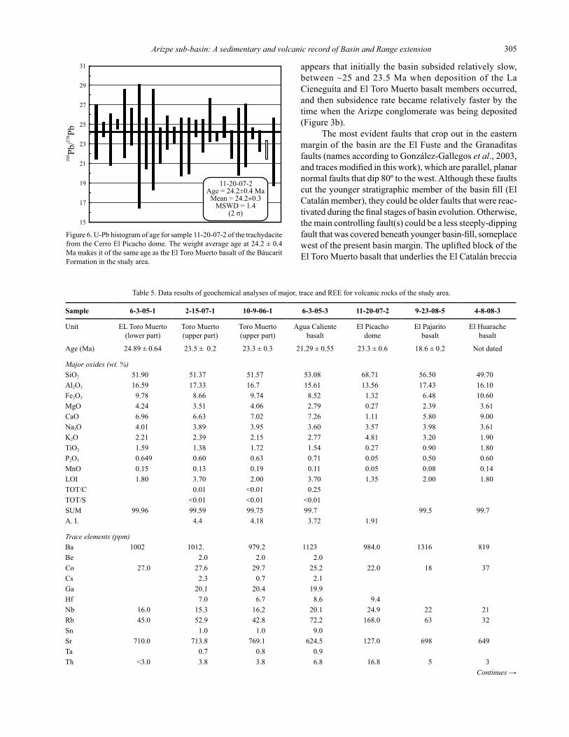
Sample 6-3-05-1 2-15-07-1 10-9-06-1 6-3-05-3 11-20-07-2 9-23-08-5 4-8-08-3
Unit ELToroMuerto(lowerpart)
ToroMuerto(upperpart)
ToroMuerto(upperpart)
AguaCalientebasalt
ElPicachodome
ElPajaritobasalt
ElHuarachebasalt
Age(Ma) 24.89±0.64 23.5±0.2 23.3±0.3 21.29±0.55 23.3±0.6 18.6±0.2 Notdated
Major oxides (wt. %)SiO2 51.90 51.37 51.57 53.08 68.71 56.50 49.70Al2O3 16.59 17.33 16.7 15.61 13.56 17.43 16.10Fe2O3 9.78 8.66 9.74 8.52 1.32 6.48 10.60MgO 4.24 3.51 4.06 2.79 0.27 2.39 3.61CaO 6.96 6.63 7.02 7.26 1.11 5.80 9.00Na2O 4.01 3.89 3.95 3.60 3.57 3.98 3.61K2O 2.21 2.39 2.15 2.77 4.81 3.20 1.90TiO2 1.59 1.38 1.72 1.54 0.27 0.90 1.80P2O5 0.649 0.60 0.63 0.71 0.05 0.50 0.60MnO 0.15 0.13 0.19 0.11 0.05 0.08 0.14LOI 1.80 3.70 2.00 3.70 1.35 2.00 1.80TOT/C 0.01 <0.01 0.25TOT/S <0.01 <0.01 <0.01SUM 99.96 99.59 99.75 99.7 99.5 99.7A.I. 4.4 4.18 3.72 1.91
Trace elements (ppm)Ba 1002 1012. 979.2 1123 984.0 1316 819Be 2.0 2.0 2.0Co 27.0 27.6 29.7 25.2 22.0 18 37Cs 2.3 0.7 2.1Ga 20.1 20.4 19.9Hf 7.0 6.7 8.6 9.4Nb 16.0 15.3 16.2 20.1 24.9 22 21Rb 45.0 52.9 42.8 72.2 168.0 63 32Sn 1.0 1.0 9.0Sr 710.0 713.8 769.1 624.5 127.0 698 649Ta 0.7 0.8 0.9Th <3.0 3.8 3.8 6.8 16.8 5 3
Continues →
Table5.Dataresultsofgeochemicalanalysesofmajor,traceandREEforvolcanicrocksofthestudyarea.

González-León et al.306
Sample 6-3-05-1 2-15-07-1 10-9-06-1 6-3-05-3 11-20-07-2 9-23-08-5 4-8-08-3
U 1.2 1.0 1.8V 175 164 197 168 13.1 97 173W 1.3 0.4 2.7Zr 241 303.1 277.2 378.1 261.0 374 227Y 28 34.3 34.9 40.7 26.39 28 31La 44.12 42.6 40.1 53.5 60.23 65.32 38.71Ce 97.72 97.7 91.1 120.2 121.2 131.19 85.29Pr 11.38 11.24 11.09 13.67 12.51 13.97 10.16Nd 46.51 44.2 43.3 52.4 43.13 51.43 41.86Sm 8.78 7.58 7.69 9.1 6.97 8.57 8.40Eu 2.30 1.96 2.13 2.3 1.19 1.92 2.21Gd 7.68 6.37 6.84 7.82 5.87 7.02 7.53Tb 1.16 1.11 1.14 1.35 0.83 1.01 1.16Dy 5.77 5 5.42 6.31 4.97 5.02 5.83Ho 1.25 1.01 0.98 1.15 0.99 1.03 1.25Er 3.24 2.8 2.77 3.26 2.98 2.82 3.27Tm 0.44 0.43 0.45 0.54 0.44 0.41 0.44Yb 2.91 2.59 2.72 3.04 3.12 2.74 2.89Lu 0.45 0.4 0.41 0.45 0.46 0.41 0.45Mo 0.5 0.4 0.9Cu 19 22.9 17.7 107.1 4 21 35Pb 9 2.6 1.9 11.4 24.9 12 5Zn 107 66 45 71 54 85 99Ni 38 24.1 23.2 25.8 0As 5.2 5.7 13.4Cd <0.1 0.1 0.2Sb 0.5 <0.1 0.3Bi <0.1 <0.1 <0.1Ag <0.1 <0.1 <0.1Au <0.5 <0.5 <0.5Hg 0.21 0.01 0.01Tl <0.1 0.1 <0.1Se <0.5 <0.5 <0.5Cr 53 17 30 72Cr2O3 0.003 0.007 0.007Ni 38.0 25.0 28.0 19.0 0.0 23Sc 14.0 16.0 14.0 0.0
Samples6-3-05-1,9-23-08-5,and4-8-08-3wereanalyzedbyXRFandICP-MSintheLaboratorioUniversitariodeGeoquímicaIsotópica,UniversidadNacionalAutónomadeMéxico.Samples2-15-07-1,10-9-06-1,and6-3-05-3wereanalyzedbyXRFandICP-MSattheGeosciencesDepartmentoftheUniversityofArizona,andsample11-20-07-2wasanalyzedbyHR-ICP-MSattheDepartmentofGeology,UniversityofWisconsin-EauClaire.
Table5(continued).Dataresultsofgeochemicalanalysesofmajor,traceandREEforvolcanicrocksofthestudyarea.
nearthebasinmargin(Figure2sectionA-B)mayindicatethat synsedimentary tectonism was significant during basin evolution.
Otherinterpretedsynsedimentaryfaultsincludethenormal,NW-SELaCieneguitaandtheTetuachifaults(Figure2).TheformeroneaffectedtheLaCieneguitamemberbeforedepositionoftheToroMuertobasalt,whilethelatteronewasactivefollowingdepositionoftheTierrasPrietasbasaltandproducedthehorst thatexposestheTetuachiignimbrite(Figure2).Ontheotherhand,theLaCieneguitaandTetuachifaultsmaybereactivatedstructuresofawidespread,althoughstilllittledocumentedNW-SE-strikingnormalfaultingeventthatoccurredinnorth-central
SonoraduringCenozoictimepriortoBasinandRangetectonism(asreportedbyGonzález-Leónet al.,2000).
AfterdepositionoftheBáucaritFormationceased,theArizpesub-basinwasdisorganizedbyayoungerphaseofnormalfaulting.ThemostimportantfaultsassociatedwiththiseventaretheNW-strikingCrisantoandTahuichopafaults,andprobablytheLasHigueritasfault(Figure2).TheCrisantofault,inthesouthernpartofthebasin,upliftedtheTarahumarabasementformingtheNW-SE-orientedhorstofLomasElQuemado(Figure2)anditsdownthrownblock formed a basin to the southwest that was filled by theSinoquipeconglomerate.TheSinoquipeconglomerate(informalname)isapoorlyconsolidatedconglomerate

Arizpe sub-basin: A sedimentary and volcanic record of Basin and Range extension 307
A-168A-160A-161
A-161A
7065555045
2
4
6
10
8
Na O
+ K
O (w
eigh
t %)
22
BasaltBasalticandesite
Andesite
Trachydacite
Dacite
Alkaline
Subalkaline
Trachybasalt
Composition of rocks of theBáucarit Formation in the Arizpe
sub-basin and El Rodeo basin
TrachyandesiteBasaltic
trachyandesite
Tierras Prietas basaltMesa Pedregosavolcanic rocksEl Toro Muerto basalt
Nearby localitiesCerro Cebadehuachivolcanic rocksBasins of central SonoraSierra Madre Occidental
El Picacho dome
Agua Caliente basalt
El Rodeo basin
SiO (weight %)2
60
Central Sonora
Figure7.Totalalkalivs.silicadiagram(afterLeBaset al., 1986) of geochemical classification of volcanic rocks of the El Toro Muerto and Agua Caliente basaltmembers,includingpreviouspublisheddatafromtheTierrasPrietasbasalt(samplesA-160,A-161andA-161AfromGonzález-Leónet al.,2000).AlsoplottedforcomparisonaredatafromtheMesaPedregosavolcanicrocks(A-168ofGonzález-Leónet al.,2000)andourdatafromtheElHuaracheandElPajaritobasaltsfromtheElRodeobasins.Otherdatafromvolcanicrockswithagesbetween28to17Mathatarementionedinthemanuscriptinclude:nearbyareasoftheRíoSonoraregion(bluepentagons)byPazMoreno(1992);theCerroCebadéhuachivolcanicrocks(fromGonzález-Leónet al.,2000),theRíoYaquiregion(blankrectangles)(fromMcDowellet al.,1997),westernSierraMadreOccidental(fromDemantet al.,1989)anddatafromcentralSonora(Tillet al.,2009).
successionthatweinferburiestheArizpeconglomerateintheSinoquipevalley(Figure2,sectionC-D).EvidenceforthisincludetheoutliersoftheElToroMuertobasaltcoveredbythisunitinthewesternmarginofthissag,andtheabsencewithinitoftheotherbasaltmembersoftheBáucaritFormationthatarepresentintheArizpesub-basin.TheTahuichopafaultdeformedtheArizpesub-basininitsnorthernparttoformthePicachodeArizpehorst,anditsverticaldisplacementaccountsforatleast2kmconsideringitexposesstrataoftheBisbeeGroupandtheTarahumaraFormationinthisarea(González-Leónet al.,2000).
ARIZPE SUB-BASIN AND REGIONAL CONTEXT
ThedatahereinreportedfromtheArizpesub-basinhelptoconstrainthetimeofextensionandmagmatismassociatedwiththeBasinandRangeeventinSonoraandinthissectionourresultsarecomparedwithdatareportedfromsimilarbasinsinotherpartsofthestate.
GeochronologyofmagmatismhereinreportedformtheArizpesub-basinmostprobablyindicateanincompleterecordofbasinevolutionconstrainedbetween~25and21Ma.TheyoungerageofdurationoftheBasinandRangeinthisregionofnorth-centralSonora,however,canbeconstrainedbytheageatnear18MathatweobtainedfromtheElPajaritobasaltinterbeddedintheupperpartofthe
sedimentary fill of the El Rodeo basin (Figure 1). These data areconsistentwiththegeochronologyofvolcanicrocksinbasinsofcentralandnorthernSonora,whichconstrainbasininitiation,between27to25Ma,toendatnear15Ma.Forinstance, mafic rock of the Báucarit Formation in the Yécora basinweredatedbetween~24and~17Ma(CocheméandDemant,1991),whileattheRíoYaquibasin(Figure1)theoldervolcanicrockshaveagesbetween~27to22Maandtheyoungerareat~17Ma(McDowellet al.,1997).LateOligocene–EarlyMioceneageswerealsoobtainedbyGans(1997)forbasalticrocksintheSantaRosaarea(Figure1)and,fortheSahuaripabasin(Figure1),BlairandGans(2003) reported ages ~28 Ma for basaltic flows at the base of the Báucarit Formation, ~25 Ma for interbedded mafic flows, and ~15 Ma for andesitic flows in the upper part of the basin fill. In northern Sonora, the lower conglomer-ateoftheBacanuchibasin(González-Leónet al.,2000)(Figure 1) interfingers with ~25 Ma rhyolitic tuffs of the “MesaPedregosavolcanicrocks”(González-Leónet al.,2000)andbothunitsunconformablyoverlythedacitictorhyoliticsuccessionofthe“CerroCebadéhuachivolcanicrocks”datedbetween28and27Ma(González-Leónet al.,2000).BasinsassociatedtometamorphiccorecomplexessuchastheMagdalena,TubutamaandUresbasins(Figure1) have interbedded mafic to rhyolitic volcanic rocks dated between~27and15Ma(Miranda-GascaandDeJong,1992;Miranda-Gascaet al.,1998;Vega-GranilloandCalmus,

González-León et al.308
c) 15.9
15.7
39
38.5
18 19.518.5 19 20
15.5
206 204Pb/ Pb
C o n t i n e n t a l r i f t
b a s a l t s
Upper Crust
Lower Crust
208
204
Pb/
P
b20
720
4P
b/
Pb
Agua Caliente basalt
El Toro Muerto basalt
Pre-Pinacate rocks (20–19 Ma)
Volcanic rocks of Sierra Santa Úrsula
0.706 0.7080.704
-5
0
5
Asthenosphere
Lithosphere
b)
87 86Sr/ Sr
εNd
Study areasamples
Sm Eu Gd Tb Dy Ho Er Tm Yb LuLa Ce Pr Nd
1000
100
10
a)Sa
mpl
e/C
hond
rite
Agua Caliente basalt
El Picacho rhyodacite
El Toro Muerto basalt
Tierras Prietas basalt andMesa Pedregosa basalt
STUDY AREA
El Pajarito basalt
El Huarache basalt
Sierra Santa Ursula
Cerro Cebadehuachi
Central Sonora
2003;WongandGans,2008).MiocenemagmatismalongcoastalSonorawithages
from~23and~14Maisandesitictorhyolitic,althoughitsassociationtoextensionalbasindevelopmentisnotclearlydocumented.ItoccursintheSierraSantaÚrsulaandintheSanCarlos-Guaymasarea(Mora-ÁlvarezandMcDowell,2000;Mora-KlepeisandMcDowell,2004)(Figure1),intheSierraLibre(MacMillanet al.,2003)(Figure1)andbetweenBahíadeKinoandPuertoLibertad,includingtheIslaTiburón(GastilandKrummenacher,1977;Gastilet al.,1999)(Figure1).
MostauthorsconsiderthattheSonoranLateOligocenetoEarlyMiocenemagmatismwasassociatedtoextensionthatoccurredinanintra-arcthatdevelopedduringlatestagesubduction of the Farallon plate along the Pacific margin ofnorthwestMexico(e.g.,Demantet al.,1989;Martin-Barajas,2000;Gans,1997;Umhoeferet al.,2001;Mora-KlepeisandMcDowell,2004;Vidal-Solanoet al.,2008).Gans(1997)andGanset al.(2007)alsonotedthatmajor
extensionaldeformationmigratedfromeasternSonora,whereitoccurredbetween28and24Ma,tocoastalSonorawhereittookplacebetween12and9Ma.
The mafic rocks of the Báucarit Formation in the Arizpesub-basinclassifyinanarrowrangeofalkalineba-saltic trachyandesite, similar to contemporaneous flows of thenearbyMesaPedregosavolcanicrocks(sampleA-168inFigure7takenfromGonzález-Leónet al.,2000).OursamplesfromtheElRodeobasinandnearbyareasreportedbyPaz-Moreno(1992)classifybetweentrachybasaltandtrachyandesite(Figure7).MaficflowsinbasinsofthewesternSierraMadreOccidentalarealkalinetrachybasaltandbasaltictrachyandesite(Báucarit,Demantet al.,1989;CocheméandDemant,1991)(Figure7),andcontemporane-ousvolcanicrocksoftheRíoYaquibasinrangefrombasal-tictrachyandesitetoandesite(McDowellet al.,1997(Figure7).SimilarrocksattheBahíaKino–PuertoLibertad–IslaTiburónregionaremostlybasaltandandesite(Gastilet al.,1979).However,amorecompletegeochemicaldata
Figure8.a)RockRREchondrite-normalizedpatternsforsamplesfromthestudyarea(includingthosefromtheElHuaracheandElPajaritobasalts)comparedwithpreviousresultsfromtheTierrasPrietasbasalt,andMesaPedregosaandCerroCebadéhuachivolcanicrocksfromtheBacanuchibasin(González-Leónet al.,2000).ComparisonisalsomadewithcontemporaneousvolcanicrocksoftheSierraSantaÚrsula(fromMora-KlepeisandMcDowell,2004)andcentralSonora(Tillet al., 2009). b) εNd vs.87Sr/86Srdiagram(afterDePaoloandDaley,2000)comparingourdatawiththepre-PinacatesuiteofVidal-Solanoet al. (2008), and the La Espuela and Mezquite Formations from the Sierra Santa Úrsula (the εNd and the Sr initials valuesofthesetwoformationswerecalculatedfromtheRb,Sr,SmandNdconcentrationsreportedintab.1ofMora-KlepeisandMcDowell,2004).c)208Pb/204Pbvs.206Pb/204Pb(afterZartmanandDoe,1981)and207Pb/204Pbvs.206Pb/204Pb (from Wilson, 2001) isotope correlation diagrams showing fields ofupperandlowercontinentalcrustandcontinentalriftbasalts,respectively.Ourdataplottedalongwithcontemporaneouspre-Pinacaterocks(Vidal-Solanoet al., 2008) and mafic rocks from Sierra Santa Úrsula (from Mora-Klepeis and McDowell, 2004) indicate apparent similar sources for these contemporaneousmagmas.

Arizpe sub-basin: A sedimentary and volcanic record of Basin and Range extension 309
base of the mafic to intermediate volcanism from central Sonorawithagesbetween~28and~17Ma,reportedbyTillet al.(2009),indicateamostlysubalkalinecharacterwithacompositionalrangefromtrachybasalttoandesite(Figure7).
TheREEchondrite-normalizedpatternsofoursam-plesoftheElToroMuerto,AguaCaliente,ElHuaracheandElPajaritobasalts,andElPichachotrachydacite(Figure8a)plotinanarrow,consistentpatternalongwiththeREEspec-traobtainedpreviouslyfromtheTierrasPrietasbasaltandfromtheMesaPedregosavolcanicrocks(González-Leónet al.,2000)(Figure8a).Thispatternexhibitanenrich-mentinlightREEanddepletioninheavyREE;itisalsosimilarbutmoredifferentiatedthantheREEspectrafromtheCerroCebadéhuachivolcanicrocks(Figure8a),whosepatternresemblesvolcanicrocks(LaEspuelaandMezquiteformations)oftheSierraSantaÚrsula(Mora-KlepeisandMcDowell,2004)(Figure8a).OurREEspectraarealsosimilartothoseofvolcanicrocksfromcentralSonorawithagesolderthan14MareportedbyTillet al.(2009).
Availableregionalisotopicdataofnearlycontempo-raneousrocksarescarceandtheyarerestrictedtotheIslaTiburón,SierraSantaÚrsulaandElPinacateareas.FortheIslaTiburón,Gastilet al.(1999)interpretedthatSrinitialisotopicratiosvaryingbetween0.7031to0.7055in20to15M.y.oldandesitictodaciticrockswerecompatiblewitha contaminated source in the mantle-wedge, without signifi-cantcontinentalcrustinteraction.TheSrratiosreportedbyMora-KlepeisandMcDowell(2004)fortheSierraSantaÚrsulaarelow(87Sr/86Sr=0.7039)fortheolderandesitic
rocks(22to18Ma),andmoreradiogenicfortheyoungerdaciticrocks(18to15Ma;87Sr/86Sr=0.7051to0.7055).ThebasaltsfromthestudyareahavehigherSrinitialratiosthanthecontemporaneousIslaTiburón,SierraSantaÚrsula,andthe pre-Pinacate mafic rocks (20 to 19 Ma, Vidal-Solano et al., 2008), and when coupled with their negative εNd values theyindicatethatmagmaswerederivedfrompartialmeltingoftheattenuatedcontinentallithosphere(Figure8b).ThePbisotopicvaluesoftheElToroMuertobasaltcomparealsowithvaluesofvolcanicrocksofthesierraSantaÚrsulaandthepre-Pinacatevolcanics,andhavesignaturesofcontinen-talriftbasaltsthatforminthecontinentallithosphere(Figure8c).Insummary,thegeochronologyandgeochemicaldatafromtheArizpesub-basincorrelatewellwithinterpreta-tionsoninitiation,durationandmagmacompositionoftheBasinandRangeregionalsetting,althoughnootherbasininSonorahasbeenstudiedindetailregardingitssedimentaryand volcanic fill.
CONCLUSIONS
TheArizpesub-basinisatypicalBasinandRangehalf-grabenwhosesedimentaryandvolcanic,east-dippingbasin fill is the 2.1 km-thick Báucarit Formation that we divideintosevenmembers.Basindurationisconstrainedbetween~25and~21MaaccordingtogeochronologyoftheElToroMuertoandAguaCalientebasaltmembersofitslower and upper parts, respectively. However, mafic flows interbeddedintheupperpartoftheElRodeobasinlocatedjusteastofthestudyareamayconstrainageofdurationoftheBasinandRangeeventbetween~25and~18Mainthisregion.
Normalfaultingwasprobablythemaincontrollingfactorofbasinsubsidenceandsedimentation.Subsidencewasrelativelyslowbetween~25and23.5Maduringde-positionoftheLaCieneguitaandElToroMuertobasaltmembers,andthenbecamerelativelyfasterbythetimetheArizpeconglomeratewasbeingdeposited.FaultsthatinitiatedbasinformationareprobablyreactivatedalongtheElFusteandGranaditasfaults,ortheyareburiedbeneaththe younger fill of the basin. Synsedimentary and post-basin faultsthatdisorganizedthebasinareNW-SE-,andN-S-strikingnormalfaults.
Geochemicaldataindicatethatmagmacompositionofthe older volcanic rocks in the basin is mafic and felsic. The ElToroMuerto,TierrasPriestasandAguaCalientebasaltmembersaremostlyalkalinebasaltictrachyandesite,andthe~23Maold,theElPicachodomeistrachydacite.ThisdomewastheprobablysourceoftheTetuachiignimbrite.REEchondrite-normalizedpatternsoftheserocksplotinanarrow,consistentpatternthatexhibitenrichmentinlightREEanddepletioninheavyREEwhichisconsistentwithcontemporaneousmagmatismofnearbybasins.ThispatternisalsosimilartotheREEspectraofsubalkalinevolcanicrocks,basalttodacite,withagesbetween28and14Ma
Sample 6-3-05-3 Agua Caliente
basalt
10-9-06-1 El Toro Muerto
basalt (upper part)
2-15-07-1 El Toro Muerto
basalt (upper part)
Rb 62.593 41.11 55.738Sr 687.023 690.677 750.082Rb/Sr 0.0911 0.0595 0.074387Rb/86Sr 0.261981 0.171143 0.21367787Sr/86Sr(t=0) 0.707594 0.706881 0.707575stderr% 0.0011 0.0012 0.0014Sm 8.96 8.645 8.312Nd 48.375 42.044 42.84Sm/Nd 0.1852 0.2056 0.1941147Sm/144Nd 0.111973 0.124699 0.117323143Nd/144Nd(t=0) 0.512388 0.512445 0.51239stderr% 0.0014 0.0012 0.0011εNd(t=0) -4.88 -3.76 -4.84Age(Ma) 21.3 24.9 23.5206Pb/204Pb 18.7552 19.0294207Pb/204Pb 15.6171 15.8241208Pb/204Pb 38.6923 39.1189
Table6.IsotopicdatafromtheElToroMuertoandAguaCalientebasaltmembersoftheBáucaritFormationinthestudyarea.
AnalysiswereperformedattheIsotopicLaboratoryoftheUniversityofArizonaandmethodsarepresentedintheAppendix.

González-León et al.310
reportedbyTillet al.(2009)fromcentralSonora.Ourgeochemicaldatacoupledwithisotopicanalyses
oftheElToroMuertoandAguaCalientebasaltmembersmostprobablyindicatethatmagmatismoftheArizpesub-basincorrespondstocontinentalriftbasaltsderivedfrompartialmeltingatthebaseofthecontinentallithosphere.
ACKNOWLEDGMENTS
WeacknowledgefinancialsupportfromConsejoNacionaldeCienciayTecnología(CONACYT)throughprojectNo.24893,andextendourthankstoMihaiDuceaandBrianMahoneyforpermissiontoperformtheisotopicanalysesherereportedattheIsotopicLaboratoryoftheGeosciencesDepartment,UniversityofArizona.OurthankstoSr.JesúsElíasMolina,ofArizpe,forgrantingpermitforaccesstoranchoLaCieneguitaandotherlandproperties.AZLaserChronispartiallysupportedbyNSF-EAR0443387and0732436.WearegratefultoCathyBusby,ScottBennettandCarlosPallaresforcriticalreviewsthathelpedtoimprovethemanuscript,toJuanPabloBernalUruchurtuand Rufino Lozano Santacruz who provided geochemical analyses and to Pablo Peñaflor Escarcega who made sample preparationforgeochemicalanalyses.
APPENDIX. ANALYTICAL METHODS
Ar-Ar dating
The 40Ar/39Ar analyses were performed at theGeochronologyLaboratoryoftheDepartmentodeGeología,CICESE.Theargonisotopeexperimentswereconductedonrockfragmentsandsanidinecrystals.ThesewereheatedwithaCoherentAr-ionInnova70claser.TheextractionsystemisonlinewithaVG5400massspectrometer.Allthesamplesandirradiationmonitors,wereirradiatedintheU-enrichedresearchreactorofUniversityofMcMasterinHamilton,Canada,atposition5CincapsuleCIC-55Aandreceivedadoseof30MW.Toblockthermalneutrons,thecapsulewascoveredwithacadmiumlinerduringirradia-tion.Asirradiationmonitors,aliquotsofstandardsanidineTCR-2(splitG93)(27.87±0.04Ma)andsanidineFCT-2C(27.84±0.04Ma)wereirradiatedalongsidethesamplesand distributed among them to determine the neutron flux variations.Uponirradiation,themonitorswerefusedinonestepwhilethesampleswerestep-heated.Theargonisotopeswerecorrectedforblank,massdiscrimination,radioactivedecayof37Arand39Arandatmosphericcontamination.FortheCaneutroninterferencereactions,thefactorsgivenbyMasliwec(1984)wereused.Thedecayconstantsrecom-mendedbySteigerandJäger(1977)wereappliedinthedataprocessing.TheequationsreportedbyYorket al.(2004) were used in all the straight line fitting routines of theargondatareduction.Theplateauagewascalculated
fromtheweightedmeanofconsecutivefractionsthatwerein agreement within 1 σ. The error in the plateau, integrated andisochronagesincludesthescatterintheirradiationmonitors[J=0.003048±0.000017].Theanalyticalpreci-sion is reported as one standard deviation (1 σ). For each sample,therelevant40Ar/39Ardataforalltheexperimentsispresented,itincludestheresultsforindividualstepsandtheintegratedages.Intheresultstable,thefractionsselectedtocalculate the plateau age are identified as well as the frac-tionsignoredintheisochronagecalculation.Thepreferredageforeachsampleishighlightedinboldtypeface.
Isotopic analysis
Theisotopicratiosof87Sr/86Sr,143Nd/144Nd,andthetraceelementconcentrationsofRb,Sr,Sm,andNdweremeasuredbythermalionizationmassspectrometryonwholerocksamples.Rocksampleswerecrushedtoaboutonethirdoftheirgrainsize.RockpowderswereputinlargeSavillexvialsanddissolvedinmixturesofhotconcentratedHF-HNO3oralternatively,mixturesofcoldconcentratedHF-HClO4.ThedissolvedsampleswerespikedwiththeCaltechRb,Sr,andmixedSm-Ndspikes(Wasserburget al.,1981;DuceaandSaleeby,1998)afterdissolution.Rb,Sr,andthebulkoftheREEswereseparatedincationcol-umnscontainingAG50W-X4resin,using1Nto4NHCl.SeparationofSmandNdwasachievedinanioncolumncontainingLNSpecresin,using0.1Nto2.5NHCl.Rbwasloaded onto single Re filaments using silica gel and H3PO4.Sr was loaded onto single Ta filaments with Ta2O5powder.Sm and Nd were loaded onto single Re filaments using platinizedcarbon,andresinbeads,respectively.
MassspectrometricanalyseswerecarriedoutattheUniversityofArizonaonanautomatedVGSectormulti-collector instrument fitted with adjustable 1011Ω FaradaycollectorsandaDalyphotomultiplier(DuceaandSaleeby,1998).ConcentrationsofRb,Sr,Sm,Ndweredeterminedbyisotopedilution,withisotopiccompositionsdeterminedonthesamespikedruns.Anoff-linemanipulationprogramwasusedforisotopedilutioncalculations.Typicalrunsconsistedofacquisitionof100isotopicratios.ThemeanresultoftenanalysesofthestandardNRbAAAperformedduringthecourseofthisstudyis:85Rb/87Rb=2.61199±20.FifteenanalysesofstandardSr987yieldedmeanratiosof:87Sr/86Sr=0.710285±7and84Sr/86Sr=0.056316±12.The mean results of five analyses of the standard nSmβperformedduringthecourseofthisstudyare:148Sm/147Sm=0.74880±21,and148Sm/152Sm=0.42110±6.Fifteenmea-surementsoftheLaJollaNdstandardwereperformedduringthecourseofthisstudy.Thestandardrunsyieldedthefol-lowingisotopicratios:142Nd/144Nd=1.14184±2,143Nd/144Nd=511853±2,145Nd/144Nd=0.348390±2,and150Nd/144Nd=0.23638±2.TheSrisotopicratiosofstandardsandsampleswerenormalizedto86Sr/88Sr=0.1194,whereastheNdiso-topicratioswerenormalizedto146Nd/144Nd=0.7219.The

Arizpe sub-basin: A sedimentary and volcanic record of Basin and Range extension 311
estimatedanalytical±2σ uncertaintiesforsamplesanalyzedinthisstudyare:87Rb/86Sr=0.35%,87Sr/86Sr=0.0014%,147Sm/144Nd=0.4%,and143Nd/144Nd=0.0012%.Proceduralblanks averaged from five determinations were: Rb 10 pg, Sr150pg,Sm2.7pg,andNd5.5pg.
WashesfromthecationcolumnseparationwereusedforseparatingPbinSr-Specresin(Eichrom,Darien,IL)columnsbyusingprotocoldevelopedattheUniversityofArizona.Sampleswereloadedin8MHNO3intheSrspeccolumns.Pbelutionisachievedvia8MHCl.LeadisotopeanalysiswasconductedonaGVInstruments(Hudson,NH)multicollectorinductivelycoupledplasmamassspectrom-eter(MC-ICPMS)attheUniversityofArizona(Thibodeauet al.,2007).Sampleswereintroducedintotheinstrumentby free aspiration with a low-flow concentric nebulizer into awatercooledchamber.Ablank,consistingof2%HNO3,wasrunbeforeeachsample.Beforeanalysis,allsampleswerespikedwithaTlsolutiontoachieveaPb/Tlratioof10.Throughouttheexperiment,thestandardNationalBureauofStandards(NBS)-981wasruntomonitorthestabilityoftheinstrument.
AllresultswereHg-correctedandempiricallynor-malizedtoTlbyusinganexponentiallawcorrection.Tocorrectformachineandinterlaboratorybias,allresultswerenormalizedtovaluesreportedbyGalerandAbouchami(2004)fortheNationalBureauofStandardsNBS-981standard(206Pb/204Pb=16.9405,207Pb/204Pb=15.4963,and208Pb/204Pb = 36.7219). Internal error reflects the reproduc-ibilityofthemeasurementsonindividualsamples,whereasexternalerrorsarederivedfromlongtermreproducibilityofNBS-981Pbstandardandresultinpartfromthemassbiaseffectswithintheinstrument.Inallcases,externalerrorexceedstheinternalerrorsandisreportedbelow.ExternalerrorsassociatedwitheachPbisotopicratioareasfollows:206Pb/204Pb=0.028%,207Pb/204Pb=0.028%,and208Pb/204Pb=0.031%.
REFERENCES
Blair,K.,Gans,P.B.,2003,StratigraphyoftheSahuaripabasinandpreliminarycomparisontotheRíoYaquibasin,east-centralSonora,Mexico:GeologicalSocietyofAmericaAbstractswithPrograms,34(6),16-13
Calles-Montijo,R..,1999,Evoluciontectonosedimentariadelascuencasterciarias:PorciónsurcuencadeUresyPuntadeAgua,SonoraCentral,Mexico:UniversidaddeSonora,tesisdemaestría,67pp.
Cochemé,J.J.,Demant,A.,1991,GeologyoftheYécoraarea,northernSierraMadreOccidnetal,MexicoinPérez-Segura,E.,Jacques-Ayala,C.(eds.),StudiesofSonorangeology:Boulder,Colorado,GeologicalSocietyofAmerica,SpecialPaper254,81-94.
De laO-Villanueva,M.,1993,Sedimentologíaypetrografíade laFormaciónBáucarit(Mioceno)enlacuencadeTonichi-LaDura,Sonora,México:UniversidadAutónomadeNuevoLeón,FacultaddeCienciasdelaTierra,TesisdeMaestría,88pp.
Demant,A.,Cochemé,J.J.,Delpretti,P.,Piguet,P.,1989,GeologyandpetrologyoftheTertiaryvolcanicsofthenorthwesternSierraMadreOccidental,Mexico:BulletinSocietéGéologiqueFrance,8,737-748.
DePaolo,D.J.,Daley,E.E.,2000,Neodymiumisotopesinbasaltsofthesouthwestbasinandrangeandlithosphericthinningduringcontinentalextension:ChemicalGeology,169(1),157-185.
Ducea, M.N., Saleeby, J.B., 1998, The age and origin of a thick mafic ultramaficrootfrombeneaththeSierraNevadabatholiths:ContributionstoMineralogyandPetrology,133(1-2),169-185.
Einsele,G.,1992,Sedimentarybasins,evolution,faciesandsedimentbudget:Germany,Springer-Verlag,628pp.
Galer,S.J.G.,Abouchami,W.,2004,MassbiascorrectionlawssuitableforMC-ICP-MSmeasurement(abstract),in14thAnnualGoldschmidtconference,:Geochimicaet.CosmochimicaActa,68,A542.
Gans,P.B.,1997,Large-magnitudeOligo-MioceneextensioninsouthernSonora:implicationsforthetectonicevolutionofnorthwestMexico:Tectonics,16(3),388-408.
Gans,P.,Wong,M.,Blair,K.,Macmillan,I.,Roldán,J.,Till,C.,Herman,S.,2007,CenozoicstructuralandmagmaticevolutionofSonora:thetransitionfromintra-arcextensiontotrans-tensionalrifting:OresandOrogenesis,AsymposiumhonoringthecareerofWilliamR.Dickinson:Tucson,Arizona,GeologicalSocietyofAmerica,ProgramwithAbstracts,97-98.
Gastil,R.G.,Krummenacher,D.,1977,ReconnaissancegeologyofcoastalSonorabetweenPuertoLobosandBahiaKino:GeologicalSocietyofAmericaBulletin,88(2),189-198.
Gastil,R.G.,Krummenacher,D.,Minch,J.,1979,TherecordofCenozoicvolcanismaroundtheGulfofCalifornia:GeologicalSocietyofAmericaBulletin,90(9),839-857.
Gastil, R.G., Neuhaus, J., Cassidy, M., Smith, J.T., Ingle, J.C.,Krummenacher, D., 1999, Geology and paleontology ofsouthwesternIslaTiburón,Sonora,Mexico:RevistaMexicanadeCienciasGeológicas,16(1),1-34.
Gehrels,G.,Valencia,V.,Pullen,A.,2006,DetritalZirconGeochronologybyLaserAblationMulticollectorICPMSattheArizonaLaserChronCenter,inOlszewski,T.D.(ed.),Geochronology:EmergingOpportunities:PaleontologySocietyPapers,12,67-76.
GeologicalSocietyofAmerica,2009,GeologicTimeScale:<http://www.geosociety.org/science/timescale/>.
González-Gallegos,A.,MoralesMorales,H.,OrantesContreras,V.,2003,CartaGeológico-MineraArizpeH12B73,Sonora,escala1:50,000:ConsejodeRecursosMinerales,GobiernoFederal.
González-León,C.,McIntosh,W.C.,Lozano-Santacruz,R.,Valencia-Moreno,M.,Amaya-Martínez,R.,RodríguezCastañeda,J.L.,2000,CretaceousandTertiarysedimentary,magmatic,andtectonicsevolutionofnorth-centralSonora(ArizpeandBacanuchiquadrangles),northwestMexico:GeologicalSocietyofAmericaBulletin,112(4),600-611.
King,R.E.,1939,GeologicalreconnaissanceinnorthernSierraMadreOccidentalofMexico:GeologicalSocietyofAmericaBulletin,50(11),1625-1722.
LeBas,M.J.,LeMaitre,R.W.,Streckeisen,A.,Zanetti,B.,1986,AChemicals classification of volcanic rocks based on the total alkali-silicadiagram:JournalofPetrology,27(3),745-750.
MacMillan,I.,Gans,P.,Roldán,J.,2003,Mid-MiocenesilicicvolcanismandrapidextensionintheSierraLibre,Sonora,Mexico(abstract):GeologicalSocietyofAmerica,AbstractwithPrograms,35(4),p.26.
Mahood,G.,Drake,R.E.,1982,K-Ardatingyoungrhyoliticrocks:acasestudyoftheSierraLaPrimavera,Jallisco,Mexico:GeologicalSocietyofAmericaBulletin,93(12),1232-1241.
MartinBarajas,A.,2000,Volcanismoyextensionen laProvinciaExtensionaldelGolfodeCalifornia:BoletíndelaSociedadGeológicaMexicana,53,72-83.
MasliwecA.,1984,Applicabilityofthe40Ar/39Armethodtothedatingoforebodies:UniversityofToronto,Ph.D.Thesis.
McDowell,F.W.,Roldán-Quintana,J.,Amaya-Martínez,R.,1997,InterrelationshipofsedimenaryandvolcanicdepositsassociatedwithTertiaryextensioninSonora,Mexico:GeologicalSocietyofAmericaBulletin,109(10),1349-1360.
Miranda-Gasca,M.,DeJong,K.A.,1992,TheMagdalenamid-Tertiaryextensionalbasin,in Clark,K.F.,Roldán-Quintana,J.,Schmidt,R.H.(eds.),GeologyandMineralResourcesofNorthernSierra

González-León et al.312
MadreOccidental,Mexico:ElPasoGeologicalSociety,FieldConference,Guidebook,377-384.
Miranda-Gasca,M.,Gomez-Caballero,J.A.,Eastoe,C.J.,1998,BoratedepositsofnorthernSonora,Mexico:stratigraphy,tectonics,stable isotopes, and fluid inclusions: Economic Geology, 93(4), 510-523.
Mora-Alvarez,G.,McDowell,F.W.,2000,MiocenevolcanismduringlatesubductionandearlyriftingintheSierraSantaUrsulaofwesternSonora,Mexico,inDelgado-Granados,H.,Aguirre-Díaz,G.,Stock,J.M.(eds.),CenozoictectonicsandvolcanismofMexico:GeologicalSocietyofAmerica,SpecialPaper334,123-141.
Mora-Klepeis,G.,McDowell,F.W.,2004,LateMiocenecalc-alkalicvolcanisminnorthwesternMexico:anexpressionofriftorsubduction-relatedmagmatism?:JournalofSouthAmericanEarthSciences,17(4),297-310.
PazMoreno,F.A.,1992,LevolcanismeMio-Plio-Quaternairedel’etatduSonora (nord-ouestduMexique):evolutionspatialeetchronologique; implicationspetrogenetiques:UniversitédeDroit,d’EconomieetdesSciencesd’Aix-Marseille,theseDocteurenSciences,250pp.
Steiger,R.H.,Jäger,E.,1977,SubcommissiononGeochronology:Convention on the use of decay constants in Geo andCosmochronology:EarthandPlanetarySciencesLetters,36(3),359-362.
Thibodeau,A.M.,Killick,D.J.,Ruiz,J.,Chesley,J.T.,Deagan,K.,Cruxent,J.M.,Lyman,W.,2007,ThestrangecaseoftheearliestsilverextractionbyEuropeancolonistsintheNewWorld:ProceedingsoftheNationalAcademyofSciencesoftheUnitedStatesofAmerica,104(9),3663-3666.
Till,C.B.,Gans,P.B.,Spera,F.J.,MacMillan,I.,Blair,K.D.,2009,Perilsofpetrotectonicmodeling:AviewfromsouthernSonora,Mexico:Journalof.VolcanologyandGeothermal.Research,186(3-4),160-168.
Umhoefer,P.J.,Dorsey,R.J.,Willsey,S.,Mayer,L.,Renne,P.,2001,StratigraphyandgeochronologyoftheComondúGroupnearLoreto,BajaCaliforniasur,Mexico:SedimentaryGeology,144(1-2),125-147.
Vega-Granillo,R.,Calmus,T.,2003,Mazatanmetamorphiccorecomplex(Sonora,Mexico):structuresalongthedetachmentfaultanditsexhumationevolution:JournalofSouthAmericanEarthSciences,16(4),193-204.
Vidal-Solano,J.R.,Demant,A.,PazMoreno,F.A.,Lapierre,H.,Ortega-Rivera,M.A.,Lee,J.K:W.,2008,InsightsintothetectonomagmaticevolutionofNWMexico:GeochronologyandgeochemistryoftheMiocenevolcanicrocksfromthePinacatearea,Sonora:GeologicalSocietyofAmericaBulletin,120(5-6),691-708.
Wasserburg,G.J.,Jacobsen,S.B.,DePaolo,DJ.,McCulloch,M.T.,Wen,T.,1981,PrecisedeterminationofSm/Ndratios,SmandNdisotopicabundancesinstandardSolutions:GeochimicaetCosmochimicaActa,45,2311-2323.
Wilson,M.,2001, Igneouspetrogenesis:TheNetherlands,KlugerAcademicPublishers,466pp.
Wong,M.S.,Gans,P.B.,2008,Geologic,structuralandthermochronologicalconstraintsonthetectonicevolutionof theSierraMazatáncore complex, Sonora, Mexico: New insighits intometamorphiccorecomplexformation:Tectonics27(TC4013),doi:10.1029/2007TC002173.
York,D.,Evensen,N.M.,López-Martínez,M.,DeBasabe-Delgado,J.,2004, Unified equations for the slope, intercept, and standard errorsofthebeststraightline:AmericanJournalofPhysics,73(3),367-375.
Zartman, R.E, Doe, B.R.., 1981, Plumbotectonics-The model:Tectonophysics,75(1-2),135-162.
Manuscriptreceived:July31,2009Correctedmanuscriptreceived:May16,2010Manuscriptaccepted:May19,2010