Embed Size (px)
Citation preview
© S
imon
J. P
ierce
07 /
2017
# 84
ARGOS, SERVING MARINE PROTECTED AREAS
07/2017 #84 2
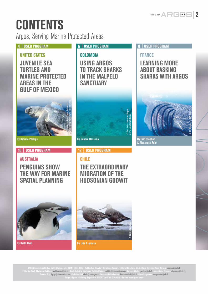
CONTENTS
ARGOS Forum is published by CLS (www.cls.fr) ISSN: 1638 -315x – Publication Director: Christophe Vassal – Editorial Directors: Marie-Claire Demmou; Yann Bernard [email protected]: Marianna Childress [email protected] - Contributed to this issue: Debbie Stakem [email protected], Garance Weller [email protected], Anne-Marie Breonce [email protected],
Thomas Gray [email protected], Christian Bull [email protected], Laurence Lebredonchel [email protected], Alexa Burgunder [email protected]: Ogham – Printing: Imprimerie DELORT certified ISO 14001 - Printed on recycled paper
Argos, Serving Marine Protected AreasUSER PROGRAM4
UNITED STATES
JUVENILE SEA TURTLES AND MARINE PROTECTED AREAS IN THE GULF OF MEXICO
By Katrina Phillips
USER PROGRAM10
AUSTRALIA
PENGUINS SHOW THE WAY FOR MARINE SPATIAL PLANNING
By Keith Reid
USER PROGRAM12
CHILE
THE EXTRAORDINARY MIGRATION OF THE HUDSONIAN GODWIT
By Luis Espinosa
USER PROGRAM6
COLOMBIA
USING ARGOS TO TRACK SHARKS IN THE MALPELO SANCTUARY
By Sandra Bessudo
USER PROGRAM8
FRANCE
LEARNING MORE ABOUT BASKING SHARKS WITH ARGOS
By Eric Stéphan & Alexandra Rohr
© M
. Kor
czak
-Abs
hire
Phot
o co
urte
sy o
f Rya
n Ch
abot
, Univ
ersit
y of
Cen
tral F
lorida
Mar
ine Tu
rtle
Rese
arch
Gro
up
© F
red
Buyle
- Fu
ndac
ión M
alpelo
y o
tros E
cosis
tem
as M
arino
s
© R
. Her
bert
- A
PEC
Ss
© L
uis
Espi
nosa
#84 07/20173
In 2016, Chile designated two key marine protected areas for ecology and marine biodiversity, promoting it to the top rank of countries with the largest marine and coastal protected areas in the world and contributing significantly to its commitment to the UN Convention on Biological Diversity.
The first of these protected areas, the Nazca-Desventuradas Marine Park, comprises 300,000 km2 - more than 8% of the Chilean EEZ. It is the largest marine park in the Americas, characterized by a unique ocean environment including tropical and temperate waters of great ecological importance (sea turtles, macro-algae forests, blue whales, deep-sea corals, deep-sea sharks, swordfish, etc.).
The second is a coastal marine protected area for multiple use named "Sea of Juan Fernández". It covers an area of approximately 11,000 km2, and within its boundaries are two marine parks: “Montes Submarinos Crusoe y Selkirk” and “Red de cuatro Parques Marinos”.
In 2017, Chile will add a new marine park of approximately 100,000 km2 near Cabo de Hornos and Diego Ramírez Islands in the Region of Magallanes and the Chilean Antarctic, consolidating its position as world leader in the field of conservation and marine biodiversity.
Subpesca (Undersecretariat of Fisheries and Aquaculture) and Sernapesca (National Fisheries and Aquaculture Service) have worked hand in hand with the Ministry of Environment and Chilean Navy to ensure the long-term viability of these areas, not only with respect to fisheries, but also for scientific observation purposes and the development of research programs or environmental studies.
In this perspective, the Argos satellite data collection and telemetry system has been a critical component of marine resources management in Chile since the 1980s, when the first Vessel Monitoring System (VMS) was established. The Argos system has also contributed to the control of marine reserve areas and to the study and understanding of marine species: habitats, distribution, migratory patterns and routes, ecological interactions between organisms, etc. It will continue to be a key technology for the management of marine parks in Chile and beyond.
As Director of Sernapesca, it is a great pleasure to welcome the international community to the Fourth International Congress on Marine Protected Areas [IMPAC-4] hosted by Chile. And as a marine biologist, it is an honor to highlight the work done with the Argos system to contribute to the protection of the planet's biodiversity, especially within Marine Protected Areas.
All Argos publications are available at:www.argos-system.org
Jorge Toro DaponteDirector, Sernapesca (Chilean National Fisheries and Aquaculture Service)
NEWS14
PHILIPPINES
UNDERSTANDING SEA TURTLES IN TUBBATAHA REEFS NATURAL PARK
By Pierre Gilles
© S
imon
J. P
ierce
E
PROJECTS15
EUROPE
INTRODUCING A NEW DATA PORTAL MERGING EARTH OBSERVATION & WILDLIFE TRACKING DATA!
By Garance Weller
By Katrina Phillips, University of Central Florida
4JUVENILE SEA TURTLES AND MARINE PROTECTED AREAS IN THE GULF OF MEXICO
USER PROGRAM | UNITED STATES
All sea turtles living in U.S. waters are listed as either endangered or threatened under the federal Endangered Species Act. Turtles face both natural threats and human-caused threats, including accidental capture in fishing gear, poaching and habitat destruction. The Gulf of Mexico is home to 5 of the 7 sea turtle species, who use the Gulf and its coastal habitats during critical lifecycle phases, including nesting and breeding. In the Gulf of Mexico, there are 295 MPAs, covering over 280,000 square kilometers of open water and coastline, where human activities, including fishing, are regulated. Katrina Phillips, of the University of Central Florida, uses Argos satellite telemetry data from 2011-2016 to take a closer look at the overlap between protected areas and sea turtle movement patterns in the Gulf of Mexico.
Sea turtle “Lost Year”The majority of marine turtle research focuses on adult females because they are easy to sample during the brief periods they spend on land to nest, but little is known about juvenile sea turtle habitats. After hatching, sea turtles swim far offshore and are generally not observed again until they recruit to coastal foraging habitats as larger juveniles. The cryptic early period of sea turtle life history, originally termed the ‘lost year’ (Carr 1986), likely spans several years or longer (Carr 1987, Bjorndal 2000).
Research goalsHabitat protection is a useful tool for supporting popula-tion recovery in imperiled species. Characterizing habitat use is difficult for marine organisms, particularly highly migratory species such as sea turtles. Field observations and Argos telemetry studies provide valuable insight into habitat use, providing the data needed to identify target locations for protected habitat. Several areas are currently designated as ‘critical habitat’ for loggerhead turtles (Caretta caretta) under the U.S. Endangered Spe-cies Act, including some adult migratory routes, nesting beaches, and breeding areas, as well as oceanic juvenile Sargassum habitat. Many of the areas identified are found within the Gulf of Mexico, a diverse environment that supports numerous sea turtle species and life stages. No critical habitat is currently designated in the Gulf of Mexico for adult or immature Kemp's ridley (Lepidochelys kempii), green turtles (Cheloniamydas), or hawksbills (Eretmochelys imbricata). In the meantime, marine protected areas may offer benefits to these species.
MethodsWe used Microwave Telemetry 9.5g solar Argos PTTs to track 71 wild-caught oceanic juveniles in the Gulf of Mexico between 2011 and 2016, including Kemp’s ridleys, green turtles, hawksbills, and loggerheads (Putman and Mansfield 2015). We evaluated the overlap of capture locations and subsequent movements with established state and federal marine protected areas, including the Sargassum critical habitat designated for loggerheads.
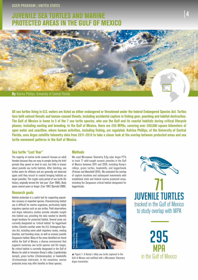
Figure 1: A Kemp's ridley sea turtle captured in the Gulf of Mexico and outfitted with a Microwave Telemetry Argos transmitter.
Photo
cour
tesy o
f Rya
n Ch
abot,
Univ
ersit
y of C
entra
l Flor
ida M
arine
Tu
rtle R
esea
rch
Grou
p.
© G
usta
vo S
tahe
lin, U
niver
sity o
f Cen
tral F
lorida
Mar
ine Tu
rtle
Rese
arch
Gro
up
71 JUVENILE TURTLES tracked in the Gulf of Mexico to study overlap with MPA
295 MPA
in the Gulf of Mexico
By Katrina Phillips, University of Central Florida
4
Key findingsThe majority of individuals tracked entered a marine protected area during the tracking period. However, gaps exist, particularly for Kemp's ridleys and green turtles in the eastern Gulf of Mexico. These gaps sug-gest that unique critical habitat designation for these species could provide increased conservation. Several turtles were tracked beyond U.S. jurisdiction, illustrating a need for international coordination to manage impor-tant juvenile habitats and support population recovery for these species.
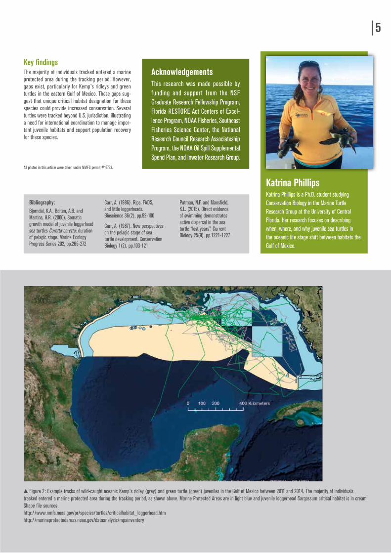
Figure 2: Example tracks of wild-caught oceanic Kemp's ridley (grey) and green turtle (green) juveniles in the Gulf of Mexico between 2011 and 2014. The majority of individuals tracked entered a marine protected area during the tracking period, as shown above. Marine Protected Areas are in light blue and juvenile loggerhead Sargassum critical habitat is in cream. Shape file sources:http:/ /www.nmfs.noaa.gov/pr/species/turtles/criticalhabitat_loggerhead.htmhttp:/ /marineprotectedareas.noaa.gov/dataanalysis/mpainventory
Bibliography: Bjorndal, K.A., Bolten, A.B. and Martins, H.R. (2000). Somatic growth model of juvenile loggerhead sea turtles Caretta caretta: duration of pelagic stage. Marine Ecology Progress Series 202, pp.265-272
Carr, A. (1986). Rips, FADS, and little loggerheads. Bioscience 36(2), pp.92-100
Carr, A. (1987). New perspectives on the pelagic stage of sea turtle development. Conservation Biology 1(2), pp.103-121
Putman, N.F. and Mansfield, K.L. (2015). Direct evidence of swimming demonstrates active dispersal in the sea turtle “lost years”. Current Biology 25(9), pp.1221-1227
All photos in this article were taken under NMFS permit #16733.
5
AcknowledgementsThis research was made possible by funding and support from the NSF Graduate Research Fellowship Program, Florida RESTORE Act Centers of Excel-lence Program, NOAA Fisheries, Southeast Fisheries Science Center, the National Research Council Research Associateship Program, the NOAA Oil Spill Supplemental Spend Plan, and Inwater Research Group.
Katrina PhillipsKatrina Phillips is a Ph.D. student studying Conservation Biology in the Marine Turtle Research Group at the University of Central Florida. Her research focuses on describing when, where, and why juvenile sea turtles in the oceanic life stage shift between habitats the Gulf of Mexico.
By Sandra Bessudo, Director and founder of the Malpelo and Other Marine Ecosystems Foundation
6USING ARGOS TO TRACK SHARKS IN THE MALPELO SANCTUARY
USER PROGRAM | COLOMBIA
© F
red
Buyle
- Fu
ndac
ión M
alpelo
y ot
ros E
cosis
tem
as M
arino
s.
The Malpelo and Other Marine Ecosystems Foundation, created in 1999, is a non-government, non-profit environmental organization from Colombia, whose mission is to support the Government's institutional control and monitoring, legislation, scientific research, education and conservation of marine ecosystems, especially in the Sanctuary of Fauna and Flora Malpelo (SFF Malpelo). It is one of the leading organizations dedicated to research and conservation of marine ecosystems in the country, encouraging the sustainable use of natural resources and promoting awareness within the framework of cooperation with multiple stakeholders, in order to achieve comprehensive and sustainable conservation strategies.
Sharks in the Sanctuary of Fauna and Flora MalpeloThe SFF Malpelo (3°58´N and 81°37´W) is located in the Eastern Tropical Pacific (ETP) 490 km from Buenaventura Port on the Colombian Pacific coast. With 350ha of terres-trial area and 857,150 ha of marine area, it is the largest non-fishing zone in the ETP and it provides a critical habitat for internationally threatened marine species. In particular, it is a ‘reservoir' for sharks, presenting aggre-gations of over 200 hammerhead sharks, over 1,000 silky sharks, and whale sharks. Furthermore, it is one of the few places in the world where sightings of the short-nosed ragged toothed shark have been registered.
Understanding shark movementsThe Malpelo and Other Marine Ecosystems Foundation promotes the study and protection of sharks through research projects. As a member of MIGRAMAR scientific network it has cooperated with different organizations, using Argos satellite telemetry technology, to understand the connectivity between MPA in the ETP and the spatial movements of sharks in the region.
Recent advances in Argos satellite tagging technologies have provided us with the opportunity to improve meas-urements of home range, movements and habitat use of marine predators, which at this point is particularly impor-tant given recent declines in shark populations worldwide.
The Malpelo foundation has been using Argos platform services to track satellite-tagged individuals in the Malpelo
Sanctuary since 2006, when a project with the scalloped hammerhead shark (Sphyrna lewini) started. Over these years, we have continued with satellite tagging, using MiniPAT, Spot and MK-10 tags from Wildlife Computers, with other shark species like Alopias pelagicus, Odontaspis ferox, Carcharhinus perezi, Carcharhinus galapagensis, Rhincodon typus and Cetorhinus maximus as well as commercial fish species like Istiophorus platypterus and Istiophorus albicans. Argos satellite tracking has made it possible to follow the migration of individuals and to report new records of maximum depth for some of the species.
The majority of shark satellite tracking studies have focused on determining the movement patterns and/or evaluating the depth and temperature preferences of these animals in certain regions, which provides valuable insights into the movements of marine animals and the physical oceano-graphic properties encountered during these movements.
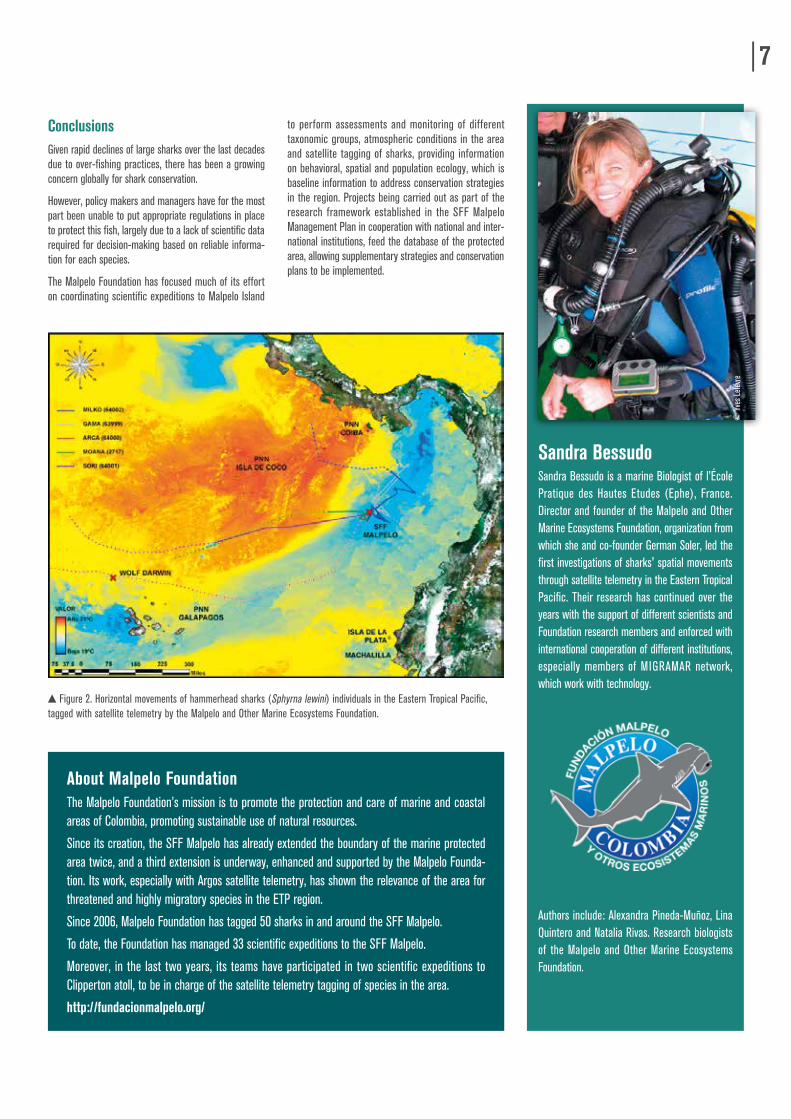
From the results obtained through this work, it has been possible to record residency of hammerheads in Malpelo and migration to other islands of the Corridor like Cocos in Costa Rica and Galapagos in Ecuador, showing connectivity between these areas and highlighting the importance of the Eastern Pacific Marine Corridor as a migration passage. In addition, the results obtained in 2013 with hammerhead sharks (S. lewini), helped to categorize the species under appendix II of CITES. It has also been possible to follow mi-gration of individuals of other species travelling further from the corridor by providing position estimates for individuals.
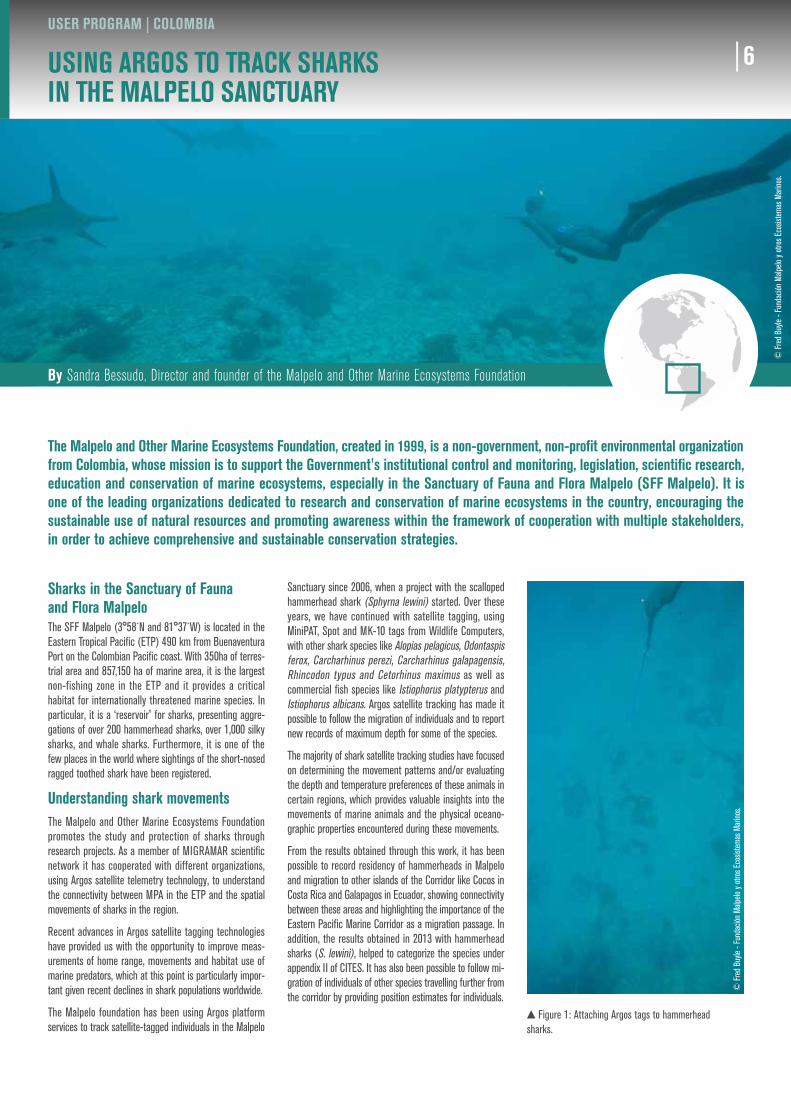
Figure 1: Attaching Argos tags to hammerhead sharks.
© F
red
Buyle
- Fu
ndac
ión M
alpelo
y ot
ros E
cosis
tem
as M
arino
s.
6
ConclusionsGiven rapid declines of large sharks over the last decades due to over-fishing practices, there has been a growing concern globally for shark conservation.
However, policy makers and managers have for the most part been unable to put appropriate regulations in place to protect this fish, largely due to a lack of scientific data required for decision-making based on reliable informa-tion for each species.
The Malpelo Foundation has focused much of its effort on coordinating scientific expeditions to Malpelo Island
to perform assessments and monitoring of different taxonomic groups, atmospheric conditions in the area and satellite tagging of sharks, providing information on behavioral, spatial and population ecology, which is baseline information to address conservation strategies in the region. Projects being carried out as part of the research framework established in the SFF Malpelo Management Plan in cooperation with national and inter-national institutions, feed the database of the protected area, allowing supplementary strategies and conservation plans to be implemented.
Sandra BessudoSandra Bessudo is a marine Biologist of l’École Pratique des Hautes Etudes (Ephe), France. Director and founder of the Malpelo and Other Marine Ecosystems Foundation, organization from which she and co-founder German Soler, led the first investigations of sharks' spatial movements through satellite telemetry in the Eastern Tropical Pacific. Their research has continued over the years with the support of different scientists and Foundation research members and enforced with international cooperation of different institutions, especially members of MIGRAMAR network, which work with technology.
Authors include: Alexandra Pineda-Muñoz, Lina Quintero and Natalia Rivas. Research biologists of the Malpelo and Other Marine Ecosystems Foundation.
7
Figure 2. Horizontal movements of hammerhead sharks (Sphyrna lewini) individuals in the Eastern Tropical Pacific, tagged with satellite telemetry by the Malpelo and Other Marine Ecosystems Foundation.
About Malpelo FoundationThe Malpelo Foundation’s mission is to promote the protection and care of marine and coastal areas of Colombia, promoting sustainable use of natural resources.
Since its creation, the SFF Malpelo has already extended the boundary of the marine protected area twice, and a third extension is underway, enhanced and supported by the Malpelo Founda-tion. Its work, especially with Argos satellite telemetry, has shown the relevance of the area for threatened and highly migratory species in the ETP region.
Since 2006, Malpelo Foundation has tagged 50 sharks in and around the SFF Malpelo.
To date, the Foundation has managed 33 scientific expeditions to the SFF Malpelo.
Moreover, in the last two years, its teams have participated in two scientific expeditions to Clipperton atoll, to be in charge of the satellite telemetry tagging of species in the area.
http://fundacionmalpelo.org/
© Y
ves L
efev
re
By Eric Stéphan, Coordinator, and Alexandra Rohr, Project Manager, APECS Association
8LEARNING MORE ABOUT BASKING SHARKS WITH ARGOS
USER PROGRAM | FRANCE
Understanding and monitoring marine species is crucial for the development of coherent and effective management practices. That is why the French Agency for Marine Protected Areas, now part of the French Agency for Biodiversity [Agence Française de la Biodiversité], quickly realized the advantages of satellite-tracking marine species in collaboration with scientists. The studies conducted by APECS (a French Association dedicated to the study and conservation of elasmobranchs) on basking sharks highlight the great potential of Argos transmitters. Indeed, for the moment little is known about the habitat of these “giants of the sea” apart from in certain coastal areas. In this article, Eric Stéphan, the Coordinator of APECS, and project manager Alexandra Rohr, share the initial results of their studies conducted in collaboration with the French Agency for Biodiversity.
The giant basking shark (Cetorhinus maximus) can measure 12 metres in length and weigh at least 4 tons. It feeds on zooplankton. Today, the species is considered cosmopolitan, living in both temperate waters and intertropical zones. However, it has rarely been observed, apart from in a few coastal areas where relatively large numbers can be seen during parts of the year (generally in the spring and summer). Usually, these are areas in which the sharks find good feeding conditions over a certain period. During these periods, they can be seen swimming on the surface alone, in pairs or in small groups. Only the dorsal fin and the tip of the caudal fin stick out above the surface of the water, although young sharks sometimes show the tip of their snout.
Unknown habitatsOutside these seasonal coastal hotspots, none of the species’ other fundamental habitats are known. However, this knowledge is crucial for establishing effective conservation measures. The species is listed on the IUCN Red List of Endangered Species and included in several international agreements, such as the OSPAR Convention and the Bonn Convention on the Conservation of Migratory Species.
The basking shark and ArgosTracking the movements of basking sharks by satellite will give us a better understanding of the ecology of the species and enable us to identify the areas they generally visit. Ultimately, this will make it possible to
protect them more effectively. The first transmitters were attached to these sharks in Europe at the start of 2000, and the first APECS transmitters attached in 2009.
In 2015, the association launched a new project called Pelargos. This 5-year project aims to pursue the work carried out since 2009, namely to study large-scale movements of the species, as well as diving behavior. The use of a new type of transmitter (Wildlife Com-puter's SPOT transmitters) will also enable real-time monitoring via the Argos system. This should make it possible to analyze the tagged sharks’ movements more closely in order to have a better understanding of how they use the French waters. The aim is to deploy ten Wildlife Computers transmitters (4 PATs and 6 SPOTs) in the zone of the Glénan archipelago off southern Finistère in Brittany, which is one of the areas of France in which basking sharks are most frequently observed.
Improving conservation strategiesOne of the APECS’ partners for this project is the new French Agency for Biodiversity, whose mission is to improve our understanding of the marine environment and to ensure its protection and management. Having a better understanding of how this migratory species uses French waters will help improve conservation strategies.
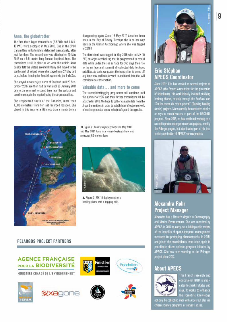
Figure 1: Argos satellite tracking tags by Wildlife Computers that can be attached to basking sharks. The MK-10 archival tags (below) record data underwater for several months before releasing and rising to the surface to transmit data. The towed SPOT tags (above) transmit data whenever the animal rises to the surface.
© E
. Sté
phan
- AP
ECS
© R
. Her
bert
- APE
CS
8 9
Anna, the globetrotterThe first three Argos transmitters (2 SPOTs and 1 MK-10 PAT) were deployed in May 2016. One of the SPOT transmitters unfortunately detached prematurely, after just five days. The second one was attached on 15 May 2016 on a 6.5- metre-long female, baptized Anna. The transmitter is still in place as we write this article. Anna quickly left the waters around Brittany and moved to the south coast of Ireland where she stayed from 27 May to 6 June, before heading for Scottish waters via the Irish Sea.
She stayed in waters just north of Scotland until 20 Sep-tember 2016. We then had to wait until 26 January 2017 before she returned to spend time near the surface and could once again be located using the Argos satellites.
She reappeared south of the Canaries, more than 4,000 kilometres from her last recorded location. She stayed in this area for a little less than a month before
disappearing again. Since 13 May 2017, Anna has been back in the Bay of Biscay. Perhaps she is on her way back to the Glénan Archipelago where she was tagged in 2016?
The third shark was tagged in May 2016 with an MK-10 PAT, an Argos archival tag that is programmed to record data while under the sea surface for 365 days then rise to the surface and transmit all collected data to Argos satellites. As such, we expect the transmitter to come off any time now and look forward to additional data that will contribute to conservation.
Valuable data… and more to comeThe transmitter/tagging programme will continue until the summer of 2017 and then further transmitters will be attached in 2018. We hope to gather valuable data from the Argos transmitters in order to establish an effective network of marine protected areas to help safeguard this species.
Eric StéphanAPECS CoordinatorSince 2002, Eric has worked on several projects at APECS (the French Association for the protection of selachians). His work initially involved studying basking sharks, notably through the EcoBask and “Sur les traces du requin pèlerin” (Tracking basking sharks) projects. More recently, he conducted studies on rays in coastal waters as part of the RECOAM program. Since 2015, he has continued working as a scientific project manager on certain projects, notably the Pelargos project, but also devotes part of his time to the coordination of APECS’ various projects.
Alexandra RohrProject ManagerAlexandra has a Master's degree in Oceanography and Marine Environments. She was recruited by APECS in 2014 to carry out a bibliographic review of the benefits of spatio-temporal management measures for protecting elasmobranchs. In 2015, she joined the association's team once again to coordinate citizen science program initiated by APECS. She has been working on the Pelargos project since 2017.
About APECSThis French research and educational NGO is dedi-cated to sharks, skates and rays. It works to enhance the scientific knowledge
not only by collecting data with Argos but also via citizen science programs or surveys at sea.
Figure 2: Anna’s trajectory between May 2016 and May 2017. Anna is a female basking shark who measures 6.5 meters long.
Figure 3: MK-10 deployment on a basking shark with a tagging pole.
© P.
Pois
son
- APE
CS
© T.
Bar
reau
- AP
ECS
PELARGOS PROJECT PARTNERS
© A
. Lef
ran
- APE
CS
By Keith Reid, Commission for the Conservation of Antarctic Marine Living Resources (CCAMLR)
10PENGUINS SHOW THE WAY FOR MARINE SPATIAL PLANNING
USER PROGRAM | AUSTRALIA
The Commission for the Conservation of Antarctic Marine Living Resources (CCAMLR) is responsible for the ecosystem-based management of fisheries in the Southern Ocean. The 'ecosystem approach' means that the effects of commercial fishing must take into account not only harvested species (target species) but also dependent species, such as marine predators for which target species are essential to their diet. For Antarctic krill, a central component to the Antarctic marine ecosystem, dependent species include seals and penguins. So the 'ecosystem approach' requires not only monitoring and estimating the krill intake of fishermen — but also that of marine predators — and understanding the spatial interactions between fishing vessels and penguins is key. Enter an innovative program that combines Vessel Monitoring System (VMS) data from fishing vessels with Argos tracks from penguins, as Keith Reid of CCAMLR explains.
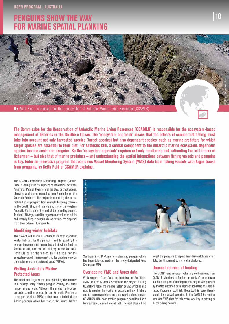
The CCAMLR Ecosystem Monitoring Program (CEMP) Fund is being used to support collaboration between Argentina, Poland, Ukraine and the USA to track Adélie, chinstrap and gentoo penguins from 8 colonies on the Antarctic Peninsula. The project is examining the at-sea distribution of penguins from multiple breeding colonies in the South Shetland Islands and along the western Antarctic Peninsula at the end of the breeding season. To date, 130 Argos satellite tags were attached to adults and recently fledged penguin chicks to track the dispersal from their colonies during winter.
Identifying winter habitatsThe project will enable scientists to identify important winter habitats for the penguins and to quantify the overlap between these penguins, all of which feed on Antarctic krill, and the krill fishery in the Antarctic Peninsula during the winter. This is crucial for the ecosystem-based management and for ongoing work on the design of marine protected areas (MPAs).
Visiting Australia’s Marine Protected AreasThe initial data suggest that after spending the summer in a muddy, noisy, smelly penguin colony, the birds range far and wide. Although the project is focused on understanding overlap in the Antarctic Peninsula to support work on MPAs in that area, it included one Adélie penguin which has visited the South Orkney
Southern Shelf MPA and one chinstrap penguin which has been detected north of the newly designated Ross Sea region MPA.
Overlapping VMS and Argos dataWith support from Collecte Localisation Satellites (CLS) and the CCAMLR Secretariat the project is using CCAMLR’s vessel monitoring system (VMS) which is also used to monitor the location of vessels in the krill fishery and to manage and share penguin tracking data. In using CCAMLR’s VMS, each tracked penguin is considered as a fishing vessel, a small one at that. The next step will be
to get the penguins to report their daily catch and effort data, but that might be more of a challenge.
Unusual sources of fundingThe CEMP Fund receives voluntary contributions from CCAMLR Members to further the work of the program. A substantial part of funding for this project was provided by monies obtained by a Member following the sale of seized Patagonian toothfish. These toothfish were illegally caught by a vessel operating in the CAMLR Convention Area and VMS data for this vessel was key in proving its illegal fishing activity.
© M
algor
zata
Kor
czak
Abs
hire
© M
algor
zata
Kor
czak
Abs
hire
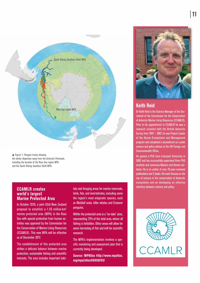
Figure 1: Penguin tracks showing the winter dispersion away from the Antarctic Peninsula, including the location of the Ross Sea region MPA and the South Orkney Southern Shelf MPA.
Ross Sea region MPA
South Orkney Southern Shelf MPA
By Keith Reid, Commission for the Conservation of Antarctic Marine Living Resources (CCAMLR)
10 11
CCAMLR creates world's largest Marine Protected AreaIn October 2016, a joint USA/New Zealand proposal to establish a 1.55 million km2
marine protected area (MPA) in the Ross Sea with special protection from human ac-tivities was approved by the Commission for the Conservation of Marine Living Resources (CCAMLR). This new MPA will be effective as of December 2017.
The establishment of this protected area strikes a delicate balance between marine protection, sustainable fishing and scientific interests. The area includes important habi-
tats and foraging areas for marine mammals, birds, fish, and invertebrates, including some the region's most enigmatic species, such as Weddell seals, killer whales and Emperor penguins.
Within the protected area is a 'no-take' zone, representing 72% of the total area, where all fishing is forbidden. Other areas will allow for some harvesting of fish and krill for scientific research.
The MPA’s implementation involves a spe-cific monitoring and assessment plan that is currently being developed.
Source: MPAtlas http://www.mpatlas.org/mpa/sites/68808295/
Keith ReidDr Keith Reid is the Science Manager at the Sec-retariat of the Commission for the Conservation of Antarctic Marine Living Resources (CCAMLR). Prior to his appointment to CCAMLR he was a research scientist with the British Antarctic Survey from 1991 – 2007, he was Project Leader of the Ocean Ecosystems and Management program and completed a secondment as a polar science and policy advisor to the UK Foreign and Commonwealth Office.
He gained a PhD from Liverpool University in 2002 and has successfully supervised three PhD students and numerous Masters and Honors stu-dents. He is an author of over 70 peer-reviewed publications and 2 books. His work focuses on the use of science in the conservation of Antarctic ecosystems and on developing an effective interface between science and policy.
By Luis Espinosa G. and Claudio Delgado S., Conservación Marina, and Fletcher Smith, The Center for Conservation
12THE EXTRAORDINARY MIGRATION OF THE HUDSONIAN GODWIT
USER PROGRAM | CHILE
In the past, many of the ideas concerning the migration of wildlife were based on isolated cases of direct sightings by a few observers. The Argos satellite tracking system made it possible to confirm existing theories or correct them, and has also led to new discoveries, with data that are available instantly to anyone around the world. The Argos system has been particularly crucial for studying the Hudsonian godwit (Limosa haemastica), a highly migratory shorebird species, as Mr. Luis Espinosa and Claudio Delgado of Conservación Marina, and Fletcher Smith, of The Center for Conservation Biology, explain in this article.
The Hudsonian godwit (Limosa haemastica) is a tiny shorebird, weighing under 400 grams and capable of migratory voyages of up to 16,000 kilometers (10,000 miles).
Chile, the winter home for shorebirdsThe south-central area of Chile is known to be important for Limosa haemastica and other migratory birds (Morrison and Ross, 1989, Espinosa et al. 2005, Espinosa et al., 2006, Andres et al., 2009, Delgado et al., 2010, Birdlife 2014) for feeding and resting during their non-reproductive periods (Espinosa et al., 2005).
Chile is home to two areas with the greatest known population density of L. haemastica: Chiloé Island (42°31’10”S–73°35’30”W), containing 99% of the Pacific population, and Bahía Lomas in Tierra del Fuego (52°40’50”S–69°13’25”W), where 58% of the Atlantic population resides, the remaining 42% being found in the Argentine area of San Sebastián.
According to the Conservation Plan for Migratory Shorebirds in Chiloé, many wintering sites are being threatened by urbanization as well as human activities such as salmon, mussels and seaweed farming (Delgado et al., 2009). Understanding the use and intensity of shorebird habitat sites as well as local patterns of movement between them are important steps towards developing appropriate management plans. Argos data can contribute to the identification of priority sites that should be protected.
Tracking godwits with ArgosIn November 2015, five Hudsonian godwits were tagged with Argos sateilite tags on Quinchao Island. The goals of the study were to determine the flyway used by Hudsonian godwits between Chiloé Island and the Northern Hemisphere, determine the size of the godwit's winter territory and identify the sites used for foraging and roosting, in order to protect any unknown high-use sites for the godwits.
Northward migrationThe godwits extraordinary migratory voyage began when the birds left Chiloé on a heading of 354°, with no stops or particular deviations before landing near Houston, Texas, USA, after a 8260 km (5100 m) that lasted 6 days. After about a week, they continued on to the central plains in such States as Oklahoma, Kansas, Nebraska, Dakota and Montana, and as far as southern Saskatchewan in Canada, from where they set off to Alaska in mid-May of 2016. Three specimens remained close to the Yukon Wildlife Preserve. The fourth of the tracked specimens settled in the south of the Kobuk Valley National Park.
© L
uis E
spino
sa
Figure 1: Hudsonian godwits.
© Lu
is Es
pinos
a
By Luis Espinosa G. and Claudio Delgado S., Conservación Marina, and Fletcher Smith, The Center for Conservation
12 13
© M
algor
zata
Kor
czak
Abs
hire
Luis A. Espinosa G.Luis A. Espinosa is a biology teacher in Chile. For almost 30 years, he has developed studies in population ecology in aquatic environments, especially with shorebirds and migratory birds.
Southward migrationThe return flight began in June, just one month after arrival. It would seem that a very wet northern spring and summer prevented successful nesting. By mid-Au-gust, all the specimens were found to be closely grouped near Saskatoon, in southern Saskatchewan. From there, they were seen to follow three separate routes to the Atlantic Ocean on their way to South America. 1) North Carolina - Caribbean - Colombia; 2) Florida - Caribbean - Panama/Colombia; and 3) Delaware/New Jersey - Caribbean - Venezuela. They then continued down the centre of South America as far as Argentinean Patagonia and reached Chiloé Island at the end of September and during October 2016, the southern spring.
Perspectives for Chiloé IslandIn conclusion, Argos satellite tracking of certain indi-vidual specimens of L. haemastica in 2016-17 provided an improved estimate of their migration routes between Chiloé in Chile and Alaska in the USA, and assisted those hoping to ensure their preservation in determining the sites they use in Chiloé for resting and feeding, as an important part of their annual cycle.
In parallel, the Western Hemisphere Shorebird Reserve Network (WHRSN) has recognized several places in Chiloé as well as Maullín, just north of Chiloé Island, as important sites for shorebirds in the Western Hemisphere.
Special thanks to Ken & Teri Pulvino Foundation.
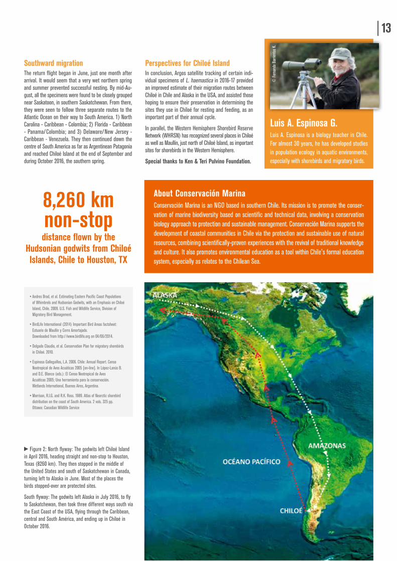
8,260 km non-stop distance flown by the
Hudsonian godwits from Chiloé Islands, Chile to Houston, TX
Figure 2: North flyway: The godwits left Chiloé Island in April 2016, heading straight and non-stop to Houston, Texas (8260 km). They then stopped in the middle of the United States and south of Saskatchewan in Canada, turning left to Alaska in June. Most of the places the birds stopped-over are protected sites.
South flyway: The godwits left Alaska in July 2016, to fly to Saskatchewan, then took three different ways south via the East Coast of the USA, flying through the Caribbean, central and South América, and ending up in Chiloé in October 2016.
• Andres Brad, et al. Estimating Eastern Pacific Coast Populations of Whimbrels and Hudsonian Godwits, with an Emphasis on Chiloé Island, Chile. 2009. U.S. Fish and Wildlife Service, Division of Migratory Bird Management.
• BirdLife International (2014) Important Bird Areas factsheet: Estuario de Maullín y Cerro Amortajado. Downloaded from http://www.birdlife.org on 04/06/2014.
• Delgado Claudio, et al. Conservation Plan for migratory shorebirds in Chiloé. 2010.
• Espinosa Galleguillos, L.A. 2006. Chile: Annual Report. Censo Neotropical de Aves Acuáticas 2005 [on-line]. In López-Lanús B. and D.E. Blanco (eds.): El Censo Neotropical de Aves Acuáticas 2005; Una herramienta para la conservación. Wetlands International, Buenos Aires, Argentina.
• Morrison, R.I.G. and R.K. Ross. 1989. Atlas of Nearctic shorebird distribution on the coast of South America. 2 vols. 325 pp. Ottawa: Canadian Wildlife Service
© F
erna
ndo
Barri
ento
s K.
About Conservación Marina Conservación Marina is an NGO based in southern Chile. Its mission is to promote the conser-vation of marine biodiversity based on scientific and technical data, involving a conservation biology approach to protection and sustainable management. Conservación Marina supports the development of coastal communities in Chile via the protection and sustainable use of natural resources, combining scientifically-proven experiences with the revival of traditional knowledge and culture. It also promotes environmental education as a tool within Chile's formal education system, especially as relates to the Chilean Sea.
14UNDERSTANDING SEA TURTLES IN TUBBATAHA REEFS NATURAL PARK
NEWS | PHILIPPINES
The Tubbataha Reefs Natural Park is a natural treasure and an exceptional habitat for endangered marine species located off the coast of the Philippines. Classified as a World Heritage Site by UNESCO for its natural beauty, it is one of two marine areas protected by national regulations in Philippine waters. The Oceanographic Institute of Monaco, whose mission is to enhance the knowledge of the richness and fragility of the oceans, and promote their sustainable management and rational and efficient protection, has launched a number of projects for the protection of marine turtles since 2015. Among these initiatives is a project to track two turtles in Tubbataha Reefs Natural Park with Argos satellite tags, in order to better understand their movement patterns and inform the general public and decision-makers about the worldwide vulnerability of this species.
H.S.H. Prince Albert II of Monaco himself and Robert Calcagno, CEO of the Oceanographic Institute, placed the Argos tags on the back of the juvenile hawksbill turtle and the adult green turtle during a visit to the Philippines in April 2016. Since then, the Oceanographic Institute has worked with Angélique Songco, Director of Tubbataha Reefs Natural Park, with the support of Dr. Nick Pilcher, member of the IUCN's Marine Turtle Specialist Group and director of the Marine Research Foundation in Malaysia, to analyze all data collected.
Contributing to park management Preliminary results show that for the moment, the turtles are behaving as expected. The green turtle has stayed in the upper part of the reefs off the southern island, feeding on marine plants, the preferred diet for green sea turtle adults. The hawksbill turtle, on the other hand, spends its time on the outer part of the reef of the Northern Island.
The data collected by the Argos system contributes to a better understanding of migratory movements of turtles on a regional level and helps the park managers to better anticipate their movements and behavior within the reef.
© S
imon
J. P
ierce
By Pierre Gilles, Project manager for ocean policy at the Oceanographic Institute of Monaco
Monaco ExplorationsThe Oceanographic Institute of Monaco will also participate in a new scientific and outreach campaign starting in August 2017, called "Monaco Explorations."
This 3-year program will take place aboard the exploration vessel M/V Yersin (77m) and will bring together scientific projects and public outreach operations. One of the program’s goals is to increase knowledge and protection of marine megafauna, including turtles, cetaceans, monk seals and sharks, which are some of the most threatened species due to human activities and global warming.
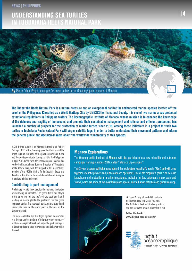
Figure 1: Map of hawksbill sea turtle tracks from May 19th-June 7th, 2017. The Tubbataha Reef atoll is clearly visible and the protected area is delineated in red.
Follow the tracks : www.institut-ocean.org/suivi/
14
Satellite Earth Observation(EO) data have been available for many years now thanks to international operational Earth Observation missions. But these data may not be known or used by research scientists such as marine biologists, ornithologists, ecologists, policy makers or marine protected area managers. The launch of a new generation of European Earth Observation satellites, the Sentinel constellation, provides the perfect opportunity to help scientists involved in biodiversity studies to access these tremendous sources of environmental data.
The main objective of the EO4wildlife project is to bring large communities of multidisciplinary research scientists involved in bio-logging activities and Argos tracking projects to collaborate closely together while using satellite Earth Observation data more extensively and efficiently.
Open and free research data portalAn open and free service platform for research is being developed, offering various big data processing tools, cross correlation and data extraction facilities to better understand animal behavior, repartition, and abundance in their environment.
Requirements from the scientific communities, perfor-mance and usefulness of the tools are addressed via four reference scenarios: the marine turtle scenario, the sea bird scenario, the pelagic fish scenario and the marine mammal scenario. Each scenario is led by a scientific expert, who represents his or her scientific community.
Users of the platform will be able to upload their Argos tracking data and correlate them with a range of observed or derived environmental
© Tu
bbat
aha
Reef
s Nat
ural
Park
By Pierre Gilles, Project manager for ocean policy at the Oceanographic Institute of Monaco
EO4WILDLIFE
PROJECTS | EUROPE
By Garance Weller, Environmental Monitoring, CLS
15Pl
ease
visit
our
web
site:
http
://w
ww.eo
4wild
life.eu
/
About the EO4wildlife project EO4wildlife project involves seven European partners from Spain, France and United Kingdom
EO4wildlife project is being financed by European Commission under grant agreement 687275.
Start and end dates: January 2016-December 2018
www.eo4wildlife.eu
E
parameters being recognized as important for these animals.
Dedicated themat ic analy t ic algorithms and habitat models are implemented for running in open access. Based on big data technol-ogies to enable processing of very large data volume, it will be possible to compute multi tracks analysis in order to better identify critical habitats in space and time and thus improve marine species protection.
WE WELCOME YOUR CONTRIBUTIONS!We know your work is interesting.Let us publish it!
Email : [email protected]
CLS HEADQUARTERS11 rue Hermès, Parc technologique du Canal31520 Ramonville Saint-Agne, FrancePh.: +33 (0)5 61 39 47 20Fax: +33 (0)5 61 39 47 97E-mail: [email protected]
NORTH AMERICA: CLS AMERICA, INC.4300 Forbes Boulevard, Suite 110Lanham, MD 20706, USAPh.: +1 301 925 4411Fax + 1 301 925 8995E-mail: [email protected]
PERÚ: CLS PERÚJr Trinidad Moran 639Lince Lima, PerúPh.: +51 1 440 2717Fax. +51 1 421 2433E-mail: [email protected]
CHILE: CUNLOGAN S.AAlmirante Señoret 70 of 74Valparaiso, ChilePh.: +56 32 225 28 43Fax +56 32 225 7294E-mail: [email protected]
BRAZIL: PROOCEANOAv. Rio Branco, n° 311 - sala 1205, Centro - Rio de Janeiro – RJ, 5CEP: 20040 – 009 - BrazilPh.: +55 21 2532.5666 E-mail: [email protected]: www.prooceano.com.br
SOUTH EAST ASIA: PT CLS INDONESIA K-Link Tower, Fl. 25 Suite AJl. Gatot Subroto, Kav 59 AJakarta Selatan, 12950, IndonesiaPh.: +62 21 29 02 69 55Fax +62 21 29 02 69 45E-mail: [email protected]
JAPAN: CUBIC-I LTD.Bluebell Bldg. 7F2-15-9 Nishi-GotandaShinagawa-kuTokyo 141-0031, JapanPh.: +81 (0)3 3779 5506Fax +81 (0)3 3779 5783E-mail: [email protected]
CHINA: CLS CHINARoom 32D, 29th Floor, Bldg A, 3A Shilibao, Chaoyang District, Beijing, ChinaE-mail: [email protected]
VIETNAM: CLS VIETNAM35 - 37, Trang Thi - Office # 102Hoan Kiem - Hanoi - VietnamPh.: + 84 4 39 34 87 39E-mail: [email protected]
KOREA: KL TRADING CO. 328 Obelisk B/D, Cheonhodearo 319Dongdaemun-Gu Seoul, South KoreaPh.: 82 2 2215 7134 5Fax 82+2+2215-7136E-mail: [email protected]
OCEANIA: CLS OCEANIAPO Box 42South Yarra, Victoria 3141 - AustraliaPh.: +61 418 368 917E-mail: [email protected]
RUSSIA: ES-PAS15-73 Leningradskoe Chaussée125171 Moscow, RussiaPh.: +7 499 150 0332Fax +7 499 150 0332E-mail: [email protected]
FUN FACTS
© S
hutte
rstoc
k
50 SHARKS TRACKED
with Argos in the Malpelo Sanctuary
71 JUVENILE TURTLES
tracked in the Gulf of Mexico to study overlap with MPAs
130 PENGUINS tracked
with Argos by CCAMLR on the Antarctic Peninsula
3% OF WORLD’S OCEANS are protected in actively
managed MPAs
625 ANIMALS tracked
by Argos in MPAs worldwide
300,000 km2 SURFACE AREA OF CHILE’S
Nazca-Desventuradas Marine Park
+22% OF FRENCH EEZ is currently a MPA
71% OF EARTH’S SURFACE
is ocean
100 ARGOS TAGS
deployed in the Galápagos marine reserve