Embed Size (px)
Citation preview
PROCEEDING, SEMINAR NASIONAL KEBUMIAN KE-10 PERAN ILMU KEBUMIAN DALAM PEMBANGUNAN INFRASTRUKTUR DI INDONESIA
13 – 14 SEPTEMBER 2017; GRHA SABHA PRAMANA
327
AREA ZONATION FOR THE APPLICATION OF RAIN HARVESTING METHOD
IN STRUCTURAL MITIGATION FLOOD AT THE WATERSHED OF BENGAWAN
SOLO BOJONEGORO DISTRICT
Arhananta
1*)
Joko Purwanto1)
Keni Christy Manurung1)
Kenny Lekatompessy1)
Muhammad Alhafiq Wahyu Nabillah1)
Dr. Ir. Eko Teguh Paripurno. MT2)
1)Student of Geological Engineering of UPN “Veteran” Yogyakarta
2)Lecturer in Geological Engineering of UPN “Veteran” Yogyakarta
Jalan SWK 104 (Lingkar utara), Condong catur, Yogyakarta
*corresponding author: [email protected]
ABSTRACT
Flooding is a disaster for many regions in Indonesia. Bojonegoro is a district which every year has a high flood threat. The cause of flood from the reviewed through google earth imageryry,
meteorological data, maps of topography, and hydrological data such of extents, discharge, and other
data about watershed Bojonegoro. Area of Bojonegoro flood occur due to overflowing of bengawan
solo rivers which the morphological is meandering river and have formed a bottle neck in the shape of the body area of the river. Sandbar river, meander scars, and oxbow lake on the imagerys which can be
interpreted that the watershed of Bengawan Solo river part of Bojonegoro is the old stadia of which
dominant the deposition of the erosion, and erosion running horizontally which allows shallowing the rivers. The average level of precipitation thatrelatively high and volume capacity reductions of the
watershed makes flooding occurs every year. Rain harvesting method is the method of structural
mitigation based on ecohydrology. Rain harvesting system has three basic elements that is namely the area of collection, conveyances system, and storage facilities. In this research emphasized at the
elements of the collection area and flood prevention in the district of Bojonegoro which is
the zonation area for application method of harvesting rain are in the headwater to the watershed
of river solo Bojonegoro. The Application of zonation based on the composition of the constituent rocks and slope. Placing of rain harvesting methods applied in the watershed of bengawan
solo that composed by loose material of sand to gravel, sandstone, and coarse grained of sedimentary
rock, and placement in areas that have a flat to gentle slope.
Keywords: Flood, Ecohydrology, Strutural Mitigation, Rain Harversting.
1. Introduction
1.1.Background
Indonesia is an archipelago state situated on the equator which is geographically flanked
by continent of Asia on the north and the continent of Australian on the south which resulted
in Indonesia having two seasons, the dry season and the rainy season. On both sides of the
season, Indonesia is experiencing problems of drought during the dry season and flooding in
the rainy season. In general structural mitigation will be built reservoir or embung, but in this
paper will be handled with the principle of ecohydrology using rain harvesting method. In
this paper focuses on the handling of flood disaster in Bengawan solo district of Bojonegoro.
1.2. Flood
Definition of Flood Disaster According to Law No.24 of 2007, disaster is defined as an
event that threatens and disrupts the lives and livelihoods of the people. Disasters can be
PROCEEDING, SEMINAR NASIONAL KEBUMIAN KE-10 PERAN ILMU KEBUMIAN DALAM PEMBANGUNAN INFRASTRUKTUR DI INDONESIA
13 – 14 SEPTEMBER 2017; GRHA SABHA PRAMANA
328
caused by natural factors and / or non-natural factors nor human factors so it emergence of
human fatalities, environmental damage, property loss, and psychological impact. Flooding is
defined as the inundated somewhere due to overflow of water that exceeds the drainage
capacity in a region and causes physical, social and economic losses (Rahayu et al, 2009).
Flooding is a seasonal threat that occurs when the body of water overflow channels
that exist and inundate the surrounding area. Flooding is natural threats which often occur and
most disadvantageous, both humanitarian and economic (IDEP, 2007). Simply the flood can
be defined as the presence of water in a large area so that covers the earth's surface area.
Particularly in Bojonegoro, floods are the most frequent disasters and be the cycle That goes
on during the rainy season. The cause of the floods that occurred in Bojonegoro due to floods
from the watershed before the city of Bojonegoro nor heavy rain that flushed during the rainy
season. According to (Dwi ratna putri, et al 2010) in the journals of the conservation
directives of Bengawan Solo river area through urban areas that the area of the Solo River
solo through Bojonegoro Urban is 34.3204 km2. The characteristic of Bengawan Solo River
of Urban has a length of 18.9 km with a slope of the river flow of about 1: 10,000, the width
of the river is approximately 150 meters with the depth of 7 meters.The maximum river
capacity ranges from m³ / sec to 1,800 m³ / sec. The result of mononobe analysis calculation
from rainfall data which used to calculate peak discharge of river water and it can be
knownthat there is an increase of river water discharge every year.
According to (Bobby Arina Rizki, 2014) in the journals of characteristic analysis of
bengawan solo river declare the extreme annual rainfall in the watershed of the headwaters of
Bengawan Solo river causes the stream flow discharge which is large in several tributaries
between Bendung Colo, Sukoharjo up to Jurug, Surakarta.The amount of flow discharge
found in each varies of tributary with each occurrence of large rain depending on which
sub-watersheds there are rainfall. The characteristics of river flood hydrograph (lateral inflow)
and flood travel time from upstream to downstream of the study can be identified by
simulation of some occurrence of rain. This research aims to know the flood characteristics in
the River of Bengawan Solo Colo Bendung Area - Surakarta City.The first step in this
research is the unit of hydrograph analysis and preliminary analysis of the watershed
parameter. Then, the hydrological model was compiled using HEC-HMS program to calibrate
the watershed parameter against the occurance of rain and real time flow discharge so
obtained the optimum parameter representing the watershed characteristics.Using the
optimum of watershed parameters which obtained, simulation of some occurance of rain can
be done. The results of this research indicate that the flood characteristics in the Bengawan
Solo River Bendung Colo - Kota Surakarta is affected by the lateral inflow of the tributaries
in the watershed, with the dominant tributaries being the Dengkeng and Samin Rivers.
1.3. Ecohydrology
Ecohydrology is a new paradigm which is a combination of hydrology and biota
dynamics in the catchment area to be applied in solving environmental problems (Zalewski et
al., 1997). Vivile & Littlewood (1997) emphasize ecohydrology as a combination of
biological sciences and physical sciences in an effort to be more understanding about
ecosystems.Vivoni (2003) states that ecohydrology studies focus on the relationship between
ecosystem patterns with soil moisture, climate and soil; As well as the role of vegetation in
water balance, surface flow energy. UNESCO (2004), states that the concept of ecohydrology
is based on 3 principles, namely framework, target and methodology. The concept of
ecohydrology with a scientific approach that takes into account the interaction of abiotic and
biotic aspects is formulated into three principles and one of the following theories:
PROCEEDING, SEMINAR NASIONAL KEBUMIAN KE-10 PERAN ILMU KEBUMIAN DALAM PEMBANGUNAN INFRASTRUKTUR DI INDONESIA
13 – 14 SEPTEMBER 2017; GRHA SABHA PRAMANA
329
The principle 1, the hydrological aspect, concerns the abiotic structure of the river system, the
dynamics of hydrological processes, and the specific spatial-temporal impacts of human
intervention;
Principle 2, which is ecological integrity, involves inter-relation of ecosystem components
showing the potential and capacity of ecosystem in producing environmental products and
services; and
Principle 3, ecotechnology, concerns the use of information and knowledge about abiotic and
biotic aspects (from principles 1 and 2) for the development of new ecotourism biotechnology
and hydrological system solutions that can enhance ecosystem capacity in producing
environmental products and services. Zalewski (2010), stated that the implementation of the
concept of ecohydrology as an integrated watershed management tool can be done with the
following four steps:
(A) monitoring threats by methods of hydrological quantification;
(B) assessing causal relationships with analysis of ecological patterns and processes;
(C) develop ecohydrological methods with ecotechnology using points (a) and (b) to increase
the production capacity and ecosystem environment services; and
(D) develop an integrated system solution by integrating the abiotic, biotic, and institutional
socioeconomic aspects.
According to (Pawitan and Haryani 2011) the needs for ecohydrology research in
Indonesia as follows:
- Research on trophic level (trophic level) in terms of balance between producers and
consumers in a lake or reservoir, and their relation to the water level
- Research in ecotonic areas between biota and water fluctuations
- Research and development of aquatic zonation
- Research development of riparian areas
- Research on improving water retention capability related to the environment
- Research fito technology to solve the problem of environmental pollution
- Urban ecohydrology research (rural ecohydrology)
- Ecohydrology research in the delta
- Research related to flood and drought
1.4. Rainwater Harvesting
According to Janette Worm and Tim van Hattum (2006), rainwater harvesting system
consists of three basic components namely, catchment area, delivery system and storage
reservoir. Catchment area or a place where the first rainwater is collected or collected, for
example the roof surface. Delivery System, is a system that drains rainwater from catchment
area to storage (storage). While the storage reservoir is where the rainwater accommodated
until the water is used for various purposes.
Norma Khoury-Nolde (2002), divides Rainwater Harvesting into several types. First,
the Occasional Type, ie water is stored for a few days only, in small containers. This type is
suitable when the rainfall pattern is same with several days without rain and when there is a
reliable alternative water source. Intermittent type, used in situations with a long rainy season
when all water needs are met by rainwater. During the dry season, water is collected from
other sources. Furthermore, the Partial Type, in this type, rainwater is used throughout the
year but the harvest is not sufficient to meet domestic needs. For example, rainwater is used
for drinking and cooking, while for other uses (eg bathing and washing) using water from
other sources. The latter is the Full Type, used year-round, the water for domestic use is
PROCEEDING, SEMINAR NASIONAL KEBUMIAN KE-10 PERAN ILMU KEBUMIAN DALAM PEMBANGUNAN INFRASTRUKTUR DI INDONESIA
13 – 14 SEPTEMBER 2017; GRHA SABHA PRAMANA
330
entirely derived from rainwater. In this case, there is usually no alternative water source other
than rain water.
Mrs. S.D. Khandagale and Mrs. V.A. Joshi stated that there are several components
that must be considered in making Rainwater Harvesting system, namely hydrogeology, land
use pattern, and hydro-meteorology. Hydrogeology includes the nature and level of aquifer,
soil cover, topography, depth and groundwater quality. Land use patterns such as land used
for industry, housing, green open spaces, etc. Hydro-meteorology includes the pattern,
duration and intensity of rainfall.
According to Patricia H. Waterfall (2004), Rainwater Harvesting has several benefits
among others, reducing the use of drinking water in other household necessities such as
bathing and washing, rainwater is a clean water that goof for plants, can prevent dryness in
plants, due to rain water that seep into the soil will reduce the accumulation of salt in the soil
that can inhibit the growth of plant roots, but it can also prevent flooding and erosion.
2. Research Methods
The method used is imagery interpretation, data overlay, map creation with ArcGIS
software, and literature study on related research.
3. Data
The resulting data are zonation map of rain harvesting method from overlay of Watershed
map, contour map, DEM map, and geological map.
4. Results and Discussion
The factors why Bojonegoro accur flooding beside from climatological factors there is a
geological factor. The first stage of discussion is interpretation of the imagery of Google Earth
Bojonegoro River watershed. Interpretation takes a form of the main stream and the
formations of which has the important geomorphological significance. Then the second stage
is to define the actual Landform and land use based on Google Earth Imageryry. Then in the
final stages of analysis carried out aspects of geomorphology. Can be found as follows:
Primary data in the form of remote sensing data GoogleEarth Imagery 2015 And 2016 is used
for actual land usage intrepetation and analysis of land form of Bengawan Solo River
Bojonegoro District.
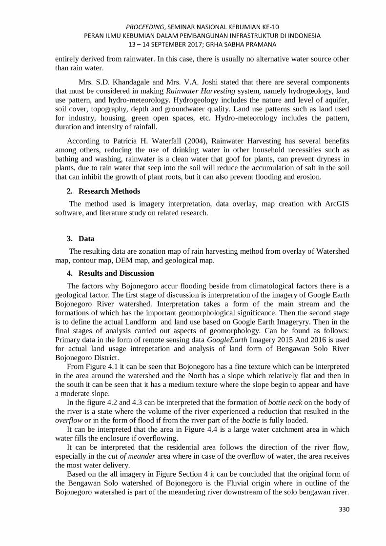
From Figure 4.1 it can be seen that Bojonegoro has a fine texture which can be interpreted
in the area around the watershed and the North has a slope which relatively flat and then in
the south it can be seen that it has a medium texture where the slope begin to appear and have
a moderate slope.
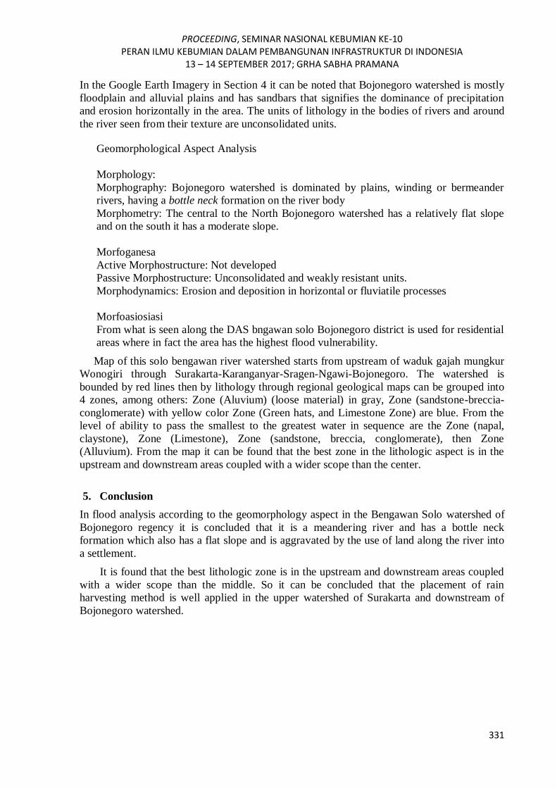
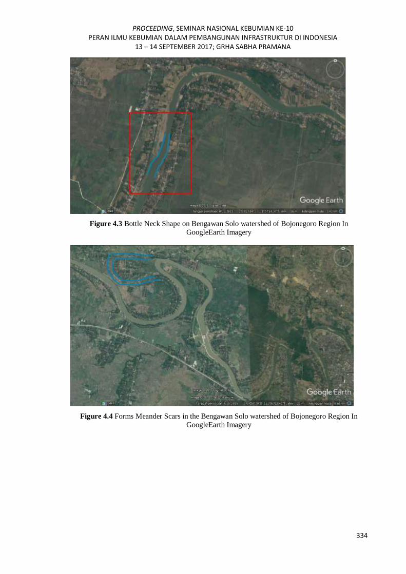
In the figure 4.2 and 4.3 can be interpreted that the formation of bottle neck on the body of
the river is a state where the volume of the river experienced a reduction that resulted in the
overflow or in the form of flood if from the river part of the bottle is fully loaded.
It can be interpreted that the area in Figure 4.4 is a large water catchment area in which
water fills the enclosure if overflowing.
It can be interpreted that the residential area follows the direction of the river flow,
especially in the cut of meander area where in case of the overflow of water, the area receives
the most water delivery.
Based on the all imagery in Figure Section 4 it can be concluded that the original form of
the Bengawan Solo watershed of Bojonegoro is the Fluvial origin where in outline of the
Bojonegoro watershed is part of the meandering river downstream of the solo bengawan river.
PROCEEDING, SEMINAR NASIONAL KEBUMIAN KE-10 PERAN ILMU KEBUMIAN DALAM PEMBANGUNAN INFRASTRUKTUR DI INDONESIA
13 – 14 SEPTEMBER 2017; GRHA SABHA PRAMANA
331
In the Google Earth Imagery in Section 4 it can be noted that Bojonegoro watershed is mostly
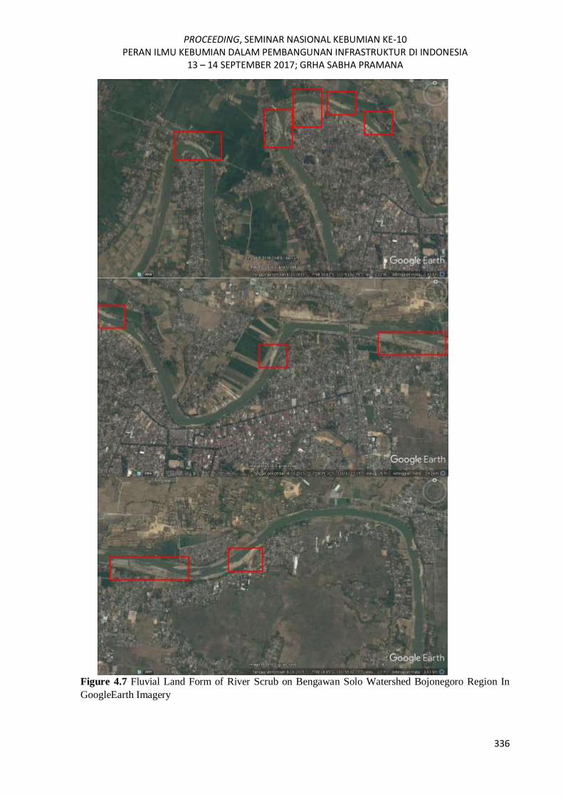
floodplain and alluvial plains and has sandbars that signifies the dominance of precipitation
and erosion horizontally in the area. The units of lithology in the bodies of rivers and around
the river seen from their texture are unconsolidated units.
Geomorphological Aspect Analysis
Morphology:
Morphography: Bojonegoro watershed is dominated by plains, winding or bermeander
rivers, having a bottle neck formation on the river body
Morphometry: The central to the North Bojonegoro watershed has a relatively flat slope
and on the south it has a moderate slope.
Morfoganesa
Active Morphostructure: Not developed
Passive Morphostructure: Unconsolidated and weakly resistant units.
Morphodynamics: Erosion and deposition in horizontal or fluviatile processes
Morfoasiosiasi
From what is seen along the DAS bngawan solo Bojonegoro district is used for residential
areas where in fact the area has the highest flood vulnerability.
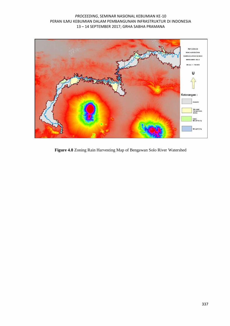
Map of this solo bengawan river watershed starts from upstream of waduk gajah mungkur
Wonogiri through Surakarta-Karanganyar-Sragen-Ngawi-Bojonegoro. The watershed is
bounded by red lines then by lithology through regional geological maps can be grouped into
4 zones, among others: Zone (Aluvium) (loose material) in gray, Zone (sandstone-breccia-
conglomerate) with yellow color Zone (Green hats, and Limestone Zone) are blue. From the
level of ability to pass the smallest to the greatest water in sequence are the Zone (napal,
claystone), Zone (Limestone), Zone (sandstone, breccia, conglomerate), then Zone
(Alluvium). From the map it can be found that the best zone in the lithologic aspect is in the
upstream and downstream areas coupled with a wider scope than the center.
5. Conclusion
In flood analysis according to the geomorphology aspect in the Bengawan Solo watershed of
Bojonegoro regency it is concluded that it is a meandering river and has a bottle neck
formation which also has a flat slope and is aggravated by the use of land along the river into
a settlement.
It is found that the best lithologic zone is in the upstream and downstream areas coupled
with a wider scope than the middle. So it can be concluded that the placement of rain
harvesting method is well applied in the upper watershed of Surakarta and downstream of
Bojonegoro watershed.
PROCEEDING, SEMINAR NASIONAL KEBUMIAN KE-10 PERAN ILMU KEBUMIAN DALAM PEMBANGUNAN INFRASTRUKTUR DI INDONESIA
13 – 14 SEPTEMBER 2017; GRHA SABHA PRAMANA
332
Acknowledgements
Thanks to Mr. Ir. Eko Teguh Paripurno, MT. Who has opened our minds as a student to get an
idea in with something new. Then, thank you to the colleagues of the Pangea Cruiser nature
activist "Tambarta" who are always there to help with the work of this paper.
References
Anon.. (2013). Rainwater harvesting. Water Aid, pp. 1-10.
H. Waterfall, P.. (2006). Harvesting Rainwater For Lanscape Use. University of Arizona ,
Arizona.
Khandagale, S. & Joshi, V., n.d. Rainwater Harvesting: Grab hold of Water Where it Falls!.
Thane, MS, India, V.P.M’s Polytechnic, pp. 1-9.
Khoury-Nolde, N., n.d. Rainwater Harvesting. Jerman, fbr, pp. 1-10.
Pawitan, H.. (2011). Konsep ekohidrologi sebagai paradigm baru pengelolaan. Jakarta, s.n., p.
11.
Putri Ratna Dwi,dkk. (2010). Arahan Konservasi Wilayah Bengawan Solo yang Melalui
Perkotaan. Universitas Brawijaya, Malang
Ramadhani,dkk. (2016). Analisis Pencemaran kualitas air sungai bengawan solo akibat
limbah industri di kecamatan Kebakkramat Kabupatren karanganyar. Universitas
Muhammadiyah Surakarta.
Rizky A. Bobi. (2014). analisis karakteristik sungai bengawan solo. Universitas Gadjah
Mada
Prasetya Herry. (2014). Kualitas Perairan Sungai Bengawan Solo di Wilayah Kabupaten
Bojonegoro Berdasarkan Indeks Keanekaragaman Plankton. Universitas Negeri
Surabaya
Soeprobowati, T. R.. (2010). Ekohidrologi Konsep Pengelolaan Lingkungan Berkelanjutan.
Indonesia, s.n.
Worm, J. & van Hattum, T.. (2006). Rainwater harvesting for domestic use. Wageningen,
Agromisa Foundation and CTA, pp. 1-84.
PROCEEDING, SEMINAR NASIONAL KEBUMIAN KE-10 PERAN ILMU KEBUMIAN DALAM PEMBANGUNAN INFRASTRUKTUR DI INDONESIA
13 – 14 SEPTEMBER 2017; GRHA SABHA PRAMANA
333
Figure 4.1 Zoom In Bengawan Solo Watershed In GoogleEarth Imagery
Figure 4.2 Bottle Neck Shape on the Bengawan Solo watershed of Bojonegoro Region In
GoogleEarth Imagery
PROCEEDING, SEMINAR NASIONAL KEBUMIAN KE-10 PERAN ILMU KEBUMIAN DALAM PEMBANGUNAN INFRASTRUKTUR DI INDONESIA
13 – 14 SEPTEMBER 2017; GRHA SABHA PRAMANA
334
Figure 4.3 Bottle Neck Shape on Bengawan Solo watershed of Bojonegoro Region In
GoogleEarth Imagery
Figure 4.4 Forms Meander Scars in the Bengawan Solo watershed of Bojonegoro Region In GoogleEarth Imagery

PROCEEDING, SEMINAR NASIONAL KEBUMIAN KE-10 PERAN ILMU KEBUMIAN DALAM PEMBANGUNAN INFRASTRUKTUR DI INDONESIA
13 – 14 SEPTEMBER 2017; GRHA SABHA PRAMANA
335
Figure 4.5 Utilization of Residential Land along the Bengawan Solo Watershed of Bojonegoro
Region in GoogleEarth Imagery
Figure 4.6 Utilization of Residential Land along the Bengawan Solo Watershed of Bojonegoro
Region in the Imagery of GoogleEarth
PROCEEDING, SEMINAR NASIONAL KEBUMIAN KE-10 PERAN ILMU KEBUMIAN DALAM PEMBANGUNAN INFRASTRUKTUR DI INDONESIA
13 – 14 SEPTEMBER 2017; GRHA SABHA PRAMANA
336
Figure 4.7 Fluvial Land Form of River Scrub on Bengawan Solo Watershed Bojonegoro Region In
GoogleEarth Imagery
PROCEEDING, SEMINAR NASIONAL KEBUMIAN KE-10 PERAN ILMU KEBUMIAN DALAM PEMBANGUNAN INFRASTRUKTUR DI INDONESIA
13 – 14 SEPTEMBER 2017; GRHA SABHA PRAMANA
337
Figure 4.8 Zoning Rain Harvesting Map of Bengawan Solo River Watershed