Embed Size (px)
Citation preview
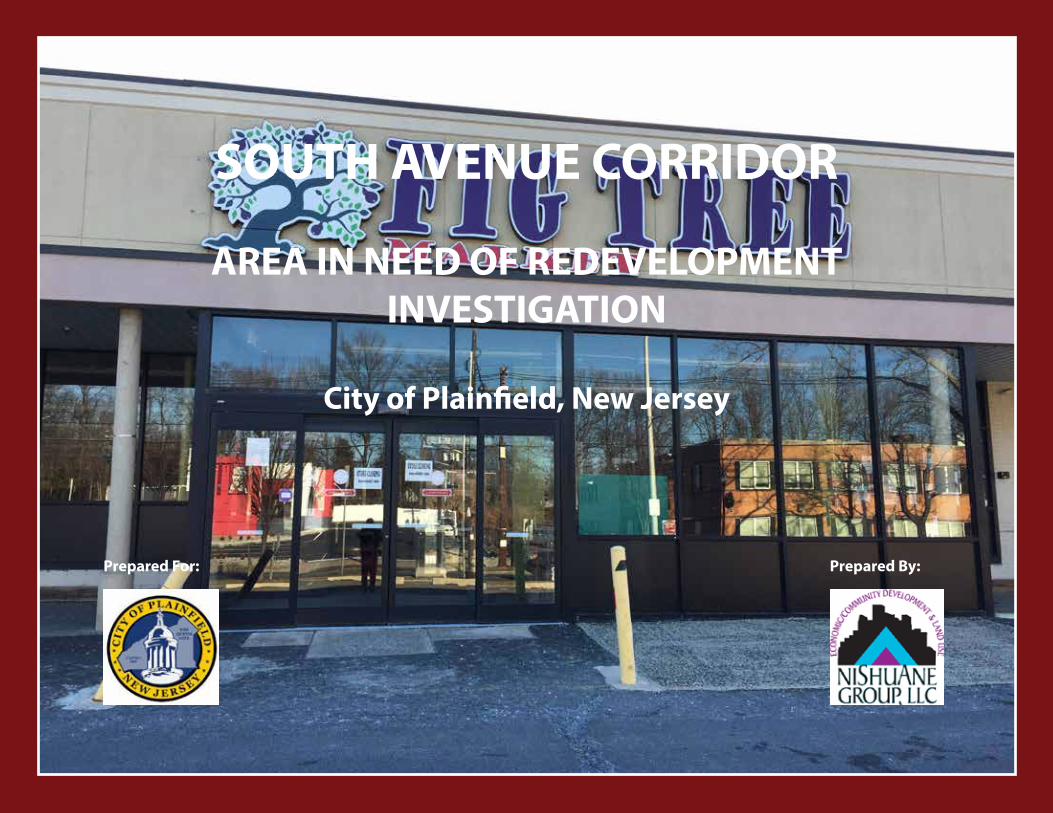
SOUTH AVENUE CORRIDOR
AREA IN NEED OF REDEVELOPMENTINVESTIGATION
City of Plainfield, New Jersey
Prepared By:Prepared For:

2
South Avenue Corridor Area in Need of Redevelopment Investigation - Non-Condemnation
City of Plainfield, Union County, New Jersey
February 6, 2020
Prepared for:
The original of this report was signed in accordance with NJSA 45:14A-12.
Prepared by:
______________________Steven Martini, PP, AICPNew Jersey Professional Planner(PP) License #33LI00633000
______________________Michele Delisfort, PP, AICPNew Jersey Professional Planner(PP) License #33LI00615500
PARK AVENUE GATEWAY AREA IN NEED OF REDEVELOPMENT INVESTIGATION
PARK AVENUE GATEWAY AREA IN NEED OF REDEVELOPMENT INVESTIGATION
3
SOUTH AVENUE CORRIDOR AREA IN NEED OF REDEVELOPMENT INVESTIGATION
1.0 INTRODUCTION 4 1.1 Study Authorization 1.2 Scope of Study 1.3 Redevelopment Objectives 1.4 Redevelopment Process 1.5 Non-Condemnation Redevelopment Area
2.0 STUDY AREA CHARACTERISTICS 6 2.1 Locational Context 2.2 Existing Land Use 2.3 Existing Zoning 2.4 Relevant Planning Studies 2.5 Urban Enterprise Zone and Smart Growth Classification 2.6 Municipal Actions
3.0 LRHL STATUTORY CRITERIA 15 3.1 Application of Study Area Criteria
4.0 STUDY AREA EVALUATION 17 4.1 Study Approach 4.2 Property Evaluation 4.3 Findings
5.0 CONCLUSION 25
TABLE OF CONTENTS
4
1.0 INTRODUCTION
In accordance with the Local Redevelopment and Housing Law, N.J.S.A. 40A:12A-1 et seq. (the “LRHL”), the City Council of the City of Plainfield (the “City Council”) adopted Resolution R188-19 on May 13, 2019, which authorized a preliminary investigation of Block 625, Lots 1, 2, and 85 on the official tax maps of the City, commonly known as 1202-1214 South Avenue, 1216-1242 South Avenue, and 513-515 Leland Avenue, respectively (the ”Study Area”) to determine whether it meets the statutory criteria to be designated as a non-condemnation redevelopment area.
Report Sections
This report contains five sections: Introduction, Study Area Characteristics, LRHL Statutory Criteria, Study Area Evaluation and Conclusion. Section 2 describes the Study Area in terms of its location, existing zoning and land use, physical, regulatory, fiscal and environmental conditions. Section 3 reviews and applies the statutory criteria and sets forth the findings based upon the characteristics and conditions of the Study Area that have been observed and analyzed. Section 4 summarizes and evaluates the Study Area, based upon the criteria set forth in the LRHL. Supporting documentation includes tax assessments, field observations, and photo surveys. Section 5 proposes recommendations to the City of Plainfield Planning Board relative to the designation of the Study Area as a non-condemnation redevelopment area.
Methodology
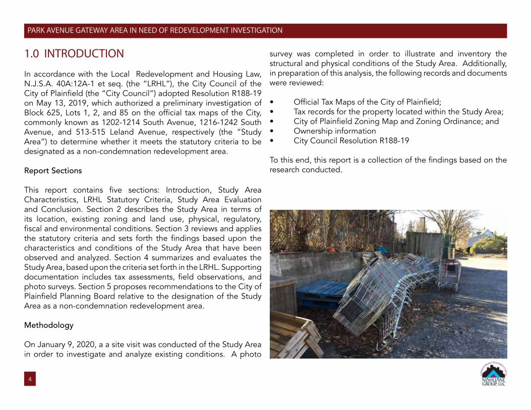
On January 9, 2020, a a site visit was conducted of the Study Area in order to investigate and analyze existing conditions. A photo
survey was completed in order to illustrate and inventory the structural and physical conditions of the Study Area. Additionally, in preparation of this analysis, the following records and documents were reviewed:
• Official Tax Maps of the City of Plainfield;• Tax records for the property located within the Study Area;• City of Plainfield Zoning Map and Zoning Ordinance; and• Ownership information• City Council Resolution R188-19
To this end, this report is a collection of the findings based on the research conducted.
PARK AVENUE GATEWAY AREA IN NEED OF REDEVELOPMENT INVESTIGATION
5
SOUTH AVENUE CORRIDOR AREA IN NEED OF REDEVELOPMENT INVESTIGATION
1.1. Study Authorization
On May 13, 2019, the City Council adopted Resolution R188-19 authorizing and directing the Planning Board to undertake an investigation of the Study Area and to make recommendations to the City Council as to whether the Study Area is “in need of redevelopment” in accordance with the criteria set forth in the LRHL. Once the Planning Board has made its recommendations, the City Council will consider whether to designate the Study Area as a Non-condemnation Redevelopment Area pursuant to the LRHL.
This report is written pursuant to Section 6 of the LRHL (N.J.S.A. 40A:12A-6) which requires the following:
1. No area of a municipality shall be determined a redevelopment area unless the governing body of the municipality shall, by resolution, authorize the planning board to undertake a preliminary investigation to determine whether the proposed area is a redevelopment area according to the criteria set forth in Section 5 of P.L. 1992/c.79 (C.40A:12A-5)... The governing body of a municipality shall assign the conduct of the investigation and hearing to the planning board of the municipality.2. (1) Before proceeding to a public hearing on the matter, the planning board shall prepare a map showing the boundaries of the proposed redevelopment area and the location of the various parcels of property included therein. There shall be appended to the map, a statement setting forth the basis of the investigation.
(2) The Planning Board shall specify a date for and give notice of a hearing for purpose of persons who are interested in or would be affected by a determination that the delineated area is
redevelopment area.
1.2. Scope of Study
This study is undertaken as a first step to engage, benefit and create opportunities through redevelopment planning, which involves the following steps:
• Conduct an inventory of the Study Area property and physical characteristics of the same;• Assess whether the existing characteristics and conditions meet the criteria to recommend the need for redevelopment, as outlined within the LRHL;• Propose findings and recommendations relevant to the determination of the need for redevelopment of the Study Area.
1.3. Redevelopment Objectives
The renewal activities of the Study Area should be undertaken in conformity with, and should be designed to meet the following objectives of an area investigation:
• To improve the functional and physical layout of the project area for contemplated new development and the removal of impediments to land deposition.• To provide redevelopment that minimizes the need to relocateresidents or businesses.• To create new employment/or housing opportunities for residents.• To coordinate redevelopment activities that mitigate and eradicate blighted conditions.
6
SOUTH AVENUE CORRIDOR AREA IN NEED OF REDEVELOPMENT INVESTIGATION
1.4 Redevelopment Process
The LRHL provides the statutory authority for municipalities to engage in a number of redevelopment activities, including: designating an “Area in Need of Redevelopment,” preparing and adopting redevelopment plans and implementing redevelopment projects. More specifically, a redevelopment designation allows the municipality to:
1. Adopt a redevelopment plan that will identify the manner in which an area will be developed, including its use and intensity.2. Issue bonds for the purpose of redevelopment.3. Acquire property.4. Lease or convey property in lieu of the public bidding process;5. Collect revenue from a selected developer.6. Grant tax exemptions and/or abatements.
The City can utilize the powers granted to municipalities under the LRHL to improve the conditions of the Study Area.
The LRHL sets forth a multi-step process that must be observed by the City Council and Planning Board in order to enable the City to lawfully exercise the powers of the LRHL. The steps required to declare an area in need of redevelopment must be undertaken pursuant to the LRHL. It should be noted that only upon completion of this public process is a municipality able to exercise the powers granted pursuant to the LRHL.
1.5 Non-Condemnation Redevelopment Areas
PP.L. 2013, Chapter 159 amended the LHRL to allow two types
of redevelopment area: Condemnation Redevelopment Areas and Non-Condemnation Redevelopment Areas. The amendment requires the resolution authorizing the planning board to undertake a preliminary investigation to state whether the redevelopment area determination shall authorize the municipality to use all those powers provided by the State Legislature for use in a redevelopment area other than the use of eminent domain (a “Non-Condemnation Redevelopment Area”) or whether the redevelopment area determination shall authorize the municipality to use all powers provided by the Legislature for use in a redevelopment area, including the power of eminent domain (a “Condemnation Redevelopment Area”). The City Council authorized a study for a Non-Condemnation Redevelopment Area for the Study Area.
2.0 STUDY AREA CHARACTERISTICS
2.1. Locational Context
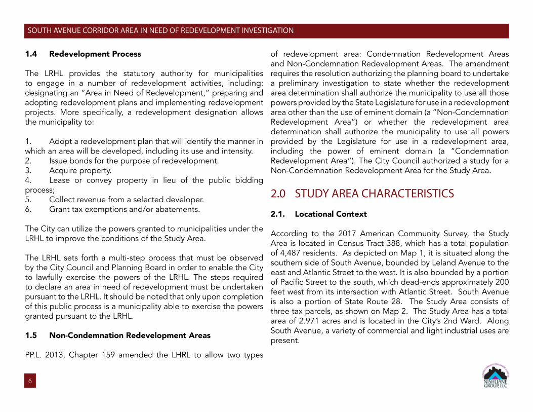
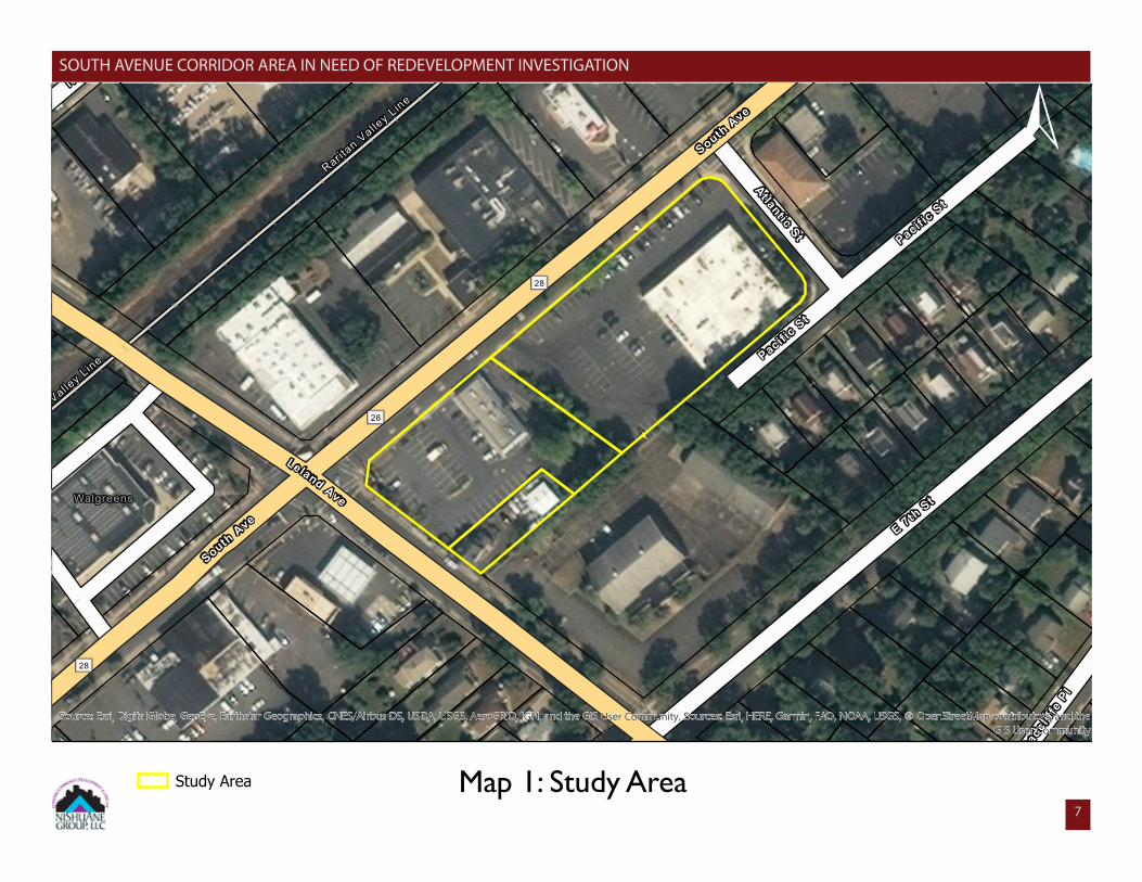
According to the 2017 American Community Survey, the Study Area is located in Census Tract 388, which has a total population of 4,487 residents. As depicted on Map 1, it is situated along the southern side of South Avenue, bounded by Leland Avenue to the east and Atlantic Street to the west. It is also bounded by a portion of Pacific Street to the south, which dead-ends approximately 200 feet west from its intersection with Atlantic Street. South Avenue is also a portion of State Route 28. The Study Area consists of three tax parcels, as shown on Map 2. The Study Area has a total area of 2.971 acres and is located in the City’s 2nd Ward. Along South Avenue, a variety of commercial and light industrial uses are present.
Raritan
Valley L
ine
28
North
Ave
Raritan
Valley L
ine
28
28
South
Ave
Leland AveWalgreens
PacificSt
AtlanticSt
South
Ave
RadcliffePl
PacificSt
E 7thSt
Source: Esri, DigitalGlobe, GeoEye, Earthstar Geographics, CNES/Airbus DS, USDA, USGS, AeroGRID, IGN, and the GIS User Community, Sources: Esri, HERE, Garmin, FAO, NOAA, USGS, © OpenStreetMap contributors, and theGIS User Community
Study Area Map 1: Study Area
±
7
SOUTH AVENUE CORRIDOR AREA IN NEED OF REDEVELOPMENT INVESTIGATION
8
SOUTH AVENUE CORRIDOR AREA IN NEED OF REDEVELOPMENT INVESTIGATION
Raritan
Valley L
ine
28
Raritan
Valley L
ine
Leland Ave
28
Walgreens
PacificSt
AtlanticSt
28
RadcliffePl
PacificSt
E7th
St
Block 623
Block 460Block461
Block 913
Block 625Block 616
Block 624Block 401
12
1
4
1
6
317
10
4
13
4.02
9 15
4
9
3
2
3837
79
75
80
5
6
3
2
9
8
5
74
11
2
10
11
14
6
416
7
73
36
76
8
84
5.01
3
85
72
81
3
2
83
4
77
10
12
2
14
78
4
1
5
5
4.01
1
7
13
8
82
7
1
Sources: Esri, HERE, Garmin, FAO, NOAA, USGS, © OpenStreetMap contributors, and the GIS User Community
±
Study Area Map 2: Tax Blocks and Lots
SOUTH AVENUE CORRIDOR AREA IN NEED OF REDEVELOPMENT INVESTIGATION
8
9
SOUTH AVENUE CORRIDOR AREA IN NEED OF REDEVELOPMENT INVESTIGATION
Regional Setting
The City of Plainfield is located within Union County, New Jersey. Plainfield is bordered by eight municipalities: in Union County, the Borough of Fanwood to the north and the Township of Scotch Plains to the north and east; in Somerset County, the Boroughs of Watchung and North Plainfield to the west; in Middlesex County, the Borough of Dunellen to the south, the Township of Piscataway to the southeast and the Borough of South Plainfield to the east.
Public Transportation
The City is served by two train stations located on New Jersey Transit’s Raritan Valley Line. These train stations are the Plainfield Train Station and the Netherwood Train Station. Additionally, there are multiple New Jersey Transit bus routes that serve the City.
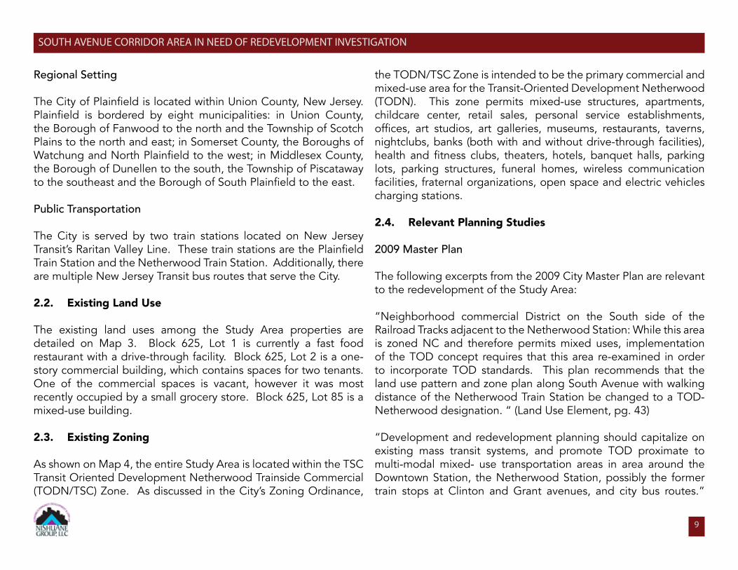
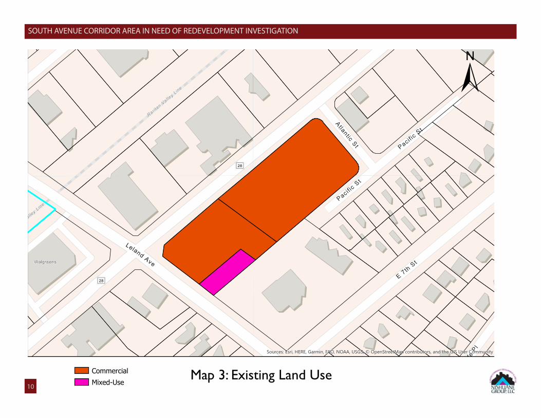
2.2. Existing Land Use
The existing land uses among the Study Area properties are detailed on Map 3. Block 625, Lot 1 is currently a fast food restaurant with a drive-through facility. Block 625, Lot 2 is a one-story commercial building, which contains spaces for two tenants. One of the commercial spaces is vacant, however it was most recently occupied by a small grocery store. Block 625, Lot 85 is a mixed-use building.
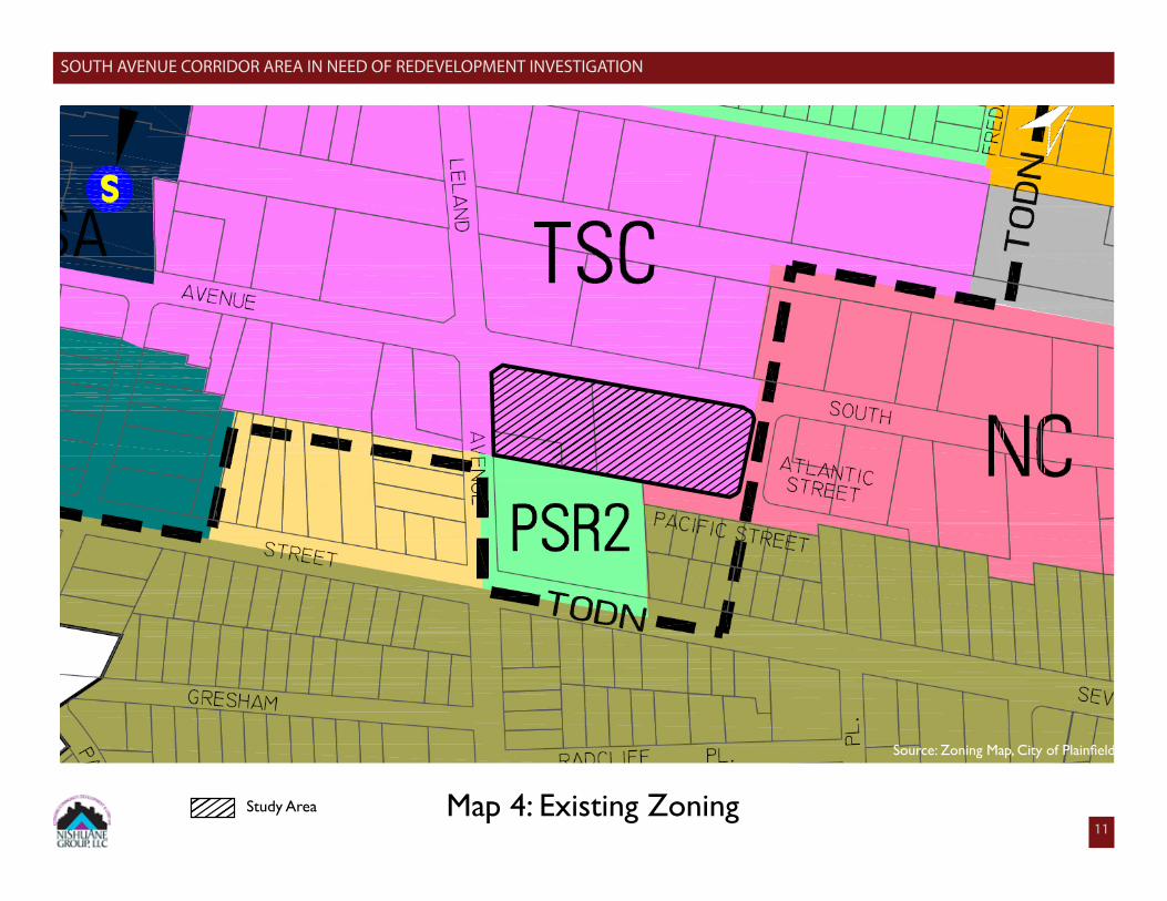
2.3. Existing Zoning As shown on Map 4, the entire Study Area is located within the TSC Transit Oriented Development Netherwood Trainside Commercial (TODN/TSC) Zone. As discussed in the City’s Zoning Ordinance,
the TODN/TSC Zone is intended to be the primary commercial and mixed-use area for the Transit-Oriented Development Netherwood (TODN). This zone permits mixed-use structures, apartments, childcare center, retail sales, personal service establishments, offices, art studios, art galleries, museums, restaurants, taverns, nightclubs, banks (both with and without drive-through facilities), health and fitness clubs, theaters, hotels, banquet halls, parking lots, parking structures, funeral homes, wireless communication facilities, fraternal organizations, open space and electric vehicles charging stations.
2.4. Relevant Planning Studies
2009 Master Plan
The following excerpts from the 2009 City Master Plan are relevant to the redevelopment of the Study Area:
“Neighborhood commercial District on the South side of the Railroad Tracks adjacent to the Netherwood Station: While this area is zoned NC and therefore permits mixed uses, implementation of the TOD concept requires that this area re-examined in order to incorporate TOD standards. This plan recommends that the land use pattern and zone plan along South Avenue with walking distance of the Netherwood Train Station be changed to a TOD-Netherwood designation. “ (Land Use Element, pg. 43)
“Development and redevelopment planning should capitalize on existing mass transit systems, and promote TOD proximate to multi-modal mixed- use transportation areas in area around the Downtown Station, the Netherwood Station, possibly the former train stops at Clinton and Grant avenues, and city bus routes.”
SOUTH AVENUE CORRIDOR AREA IN NEED OF REDEVELOPMENT INVESTIGATION
Map 3: Existing Land Use
Raritan
Valley L
ine
28
Raritan
Valley L
ine
Leland Ave
28
Walgreens
PacificSt
AtlanticSt
28
RadcliffePl
PacificSt
E7th
St
Sources: Esri, HERE, Garmin, FAO, NOAA, USGS, © OpenStreetMap contributors, and the GIS User Community
±
CommercialMixed-Use10
SOUTH AVENUE CORRIDOR AREA IN NEED OF REDEVELOPMENT INVESTIGATION
Study Area
Source: Zoning Map, City of Plainfield
Map 4: Existing Zoning
±
11
12
SOUTH AVENUE CORRIDOR AREA IN NEED OF REDEVELOPMENT INVESTIGATION
(Land Use Element, pg. 46)
“In the spring of 2008, a draft ordinance was prepared for City Council to review to establish a new zone designation, TOD-N Transit Oriented Development District – Netherwood. This proposed zoning district is intended to promote TOD to the east of the Netherwood Train Station. City Council is considering this ordinance at the time of preparation of this element.” (Land Use Element, pg. 49)
Transit Oriented Development Netherwood - North Avenue Redevelopment Plan
In 2016, the City Council approved the Transit Oriented Development Netherwood – North Avenue Redevelopment Plan. The Plan Area is bounded by North Avenue to the northwest, Berckman Street to the southwest, Leland Avenue to the northeast, and NJ Transit Raritan Valley Line to the southeast. It consists of three zones: Train Station Area Zone (TSA), Transit Commercial Zone, and Trainside Residential Zone (TSR). The goals of this Plan are to: 1. Promote Transit-Oriented Development and activity; 2. Improve economic development; 3. Increase sustainability; 4. Manage parking and traffic.
Transit Oriented Development Netherwood - North Avenue Redevelopment Plan
In 2017, the City Council approved the Transit Oriented Development Netherwood - South Avenue Redevelopment Plan. The Plan Area is bounded by South Avenue to the South, Berckman Street to the west, Netherwood Train Station to the east and NJ Transit Raritan Valley Line to the north. It consists of the Trainside Commercial
Zone. The goals of this Plan are: 1. Promote Transit-Oriented Development and activity; 2. Improve economic development; 3. Manage parking and traffic; 4. Increase sustainability.
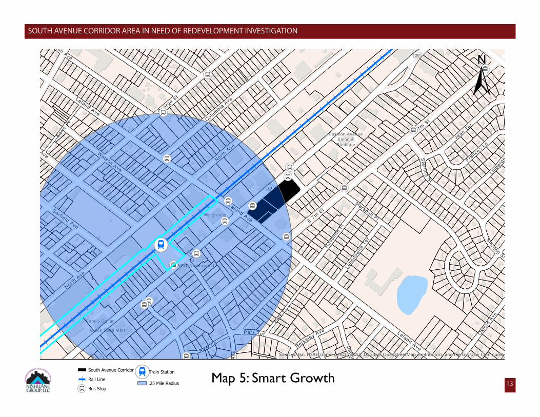
2.5. UrbanEnterpriseZoneandSmartGrowthClassification
The Study Area is not located within a City-designated Urban Enterprise Zone. The Study Area is also not located within a designated Opportunity Zone
Smart Growth Classification
Smart Growth commonly refers to growth that serves the environment, economy, and community equally. When possible, it attempts to concentrate development into already-existing communities. Additionally, it addresses the inherent interconnections between environmental protection, social equity, public health, and economic sustainability. Selected areas throughout the State of New Jersey are designated as a Smart Growth Area. They are designated by the Department of State, Office for Planning Advocacy, from spatial data relating to the NJ State Development and Redevelopment Plan, and several other master plans.
The City of Plainfield is located in the smart growth boundary for a Metropolitan Planning Area 1 (PA1). This area includes a variety of municipalities that range from a large urban centers to 19th century towns shaped by commuter rail. The communities in the area have strong ties to major metropolitan centers-New York/Newark/Jersey City Metropolitan Region; the Philadelphia/Camden/Trenton Metropolitan Region; and on a smaller scale the Easton/Phillipsburg Metropolitan Region.
13
SOUTH AVENUE CORRIDOR AREA IN NEED OF REDEVELOPMENT INVESTIGATION
South Avenue Corridor
Rail Line
Bus Stop
Train Station
.25 Mile Radius Map 5: Smart Growth
Colum
biaAve
George
St
Emerson AveEarle
Pl
Netherwood AveNorth
Ave
Watson Ave
Leland Ave
28
Raritan
Valley L
ine
Belv ide
reAve
Garfield Ave
North
Ave
Park Ter
Park L
n
Leland AveWalgreens
Quick Food Mart
Family Dollar
NJTRANSIT-Netherwood
Sterl ing
S t
Frances L
n
LinbargerAve
Jean
Ter
E7th
St
28
Fashion AvenueSalon &Boutique
Ster l i ng St
Osborne
Ave
Marshall Pl
RadcliffePl
OxfordAve
Berke
leyAve
ParkPl
LansdowneTer
Cambridge
Ave
E7th
St
Leland AveSources: Esri, HERE, Garmin, FAO, NOAA, USGS, © OpenStreetMap contributors, and the GIS User Community
±
14
SOUTH AVENUE CORRIDOR AREA IN NEED OF REDEVELOPMENT INVESTIGATION
The following are the ten (10) accepted principles of Smart Growth:
1. Mixed land uses;2. Take advantage of existing communities assets;3. Foster walkable neighborhoods;4. Create a range of housing opportunities and choices;5. Promote distinctive, attractive communities with a strong sense of place;6. Preserve open space, farmland and critical environmental area;7. Strengthen and encourage growth in existing communities;8. Provide a variety of transportation choices;9. Make development decisions predictable, fair, and cost effective; and10. Encourage citizen and stakeholder participation in development decisions.
The Study Area should be classified as a Smart Growth area because the lots are located with a quarter mile of the Netherwood Train Station and is in close proximity to several community amenities including Seider Field, Plainfield Post Office – Netherwood Station Branch, and Maxson Middle School.
2.6. Municipal Actions
Municipal records were requested from City departments regarding property management, building code violations, and other incidents that previously occurred within the Study Area. Research conducted indicates the following municipal actions.
Division of Code Enforcement and Inspections
On January 10, 2020, the Division of Code Enforcement and Inspections provided property records on file for the Study Area properties. For 1216-1242 South Avenue (Block 625, Lot 2), there was one notice of violation and court summons issued in 2016 for overgrown weeds and vegetation.
Tax Collector
On January 7, 2020, the Tax Department provided tax records for each of the Study Area properties. All properties were current on their taxes as of this date. Fire Division
The Fire Division reported on January 16, 2020 that eight incidents occurried among the Study Area properties since January 1, 2015. Four incidents involved Lot 1. Of these four, two pertained to motor vehicle accidents. Another involved EMS responding to a woman laying on the sidewalk. The fourth incident invovled a gas leak in the restaurant.
Four other incidents occurred on Lot 2. Three of these incidents pertained to a fire alarm, however there was no fire present. The fourth involved a motor vehicle fire.
Health Division
The Division of Health reported on January 16, 2020 that there were no records on file regarding the Study Area properties
15
SOUTH AVENUE CORRIDOR AREA IN NEED OF REDEVELOPMENT INVESTIGATION
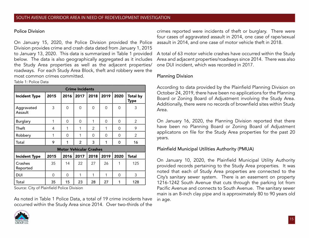
Police Division
On January 15, 2020, the Police Division provided the Police Division provides crime and crash data dated from January 1, 2015 to January 13, 2020. This data is summarized in Table 1 provided below. The data is also geographically aggregated as it includes the Study Area properties as well as the adjacent properties/roadways. For each Study Area Block, theft and robbery were the most common crimes committed. Table 1: Police Data
Crime Incidents
Incident Type 2015 2016 2017 2018 2019 2020 Total by Type
Aggravated Assault
3 0 0 0 0 0 3
Burglary 1 0 0 1 0 0 2
Theft 4 1 1 2 1 0 9
Robbery 1 0 1 0 0 0 2
Total 9 1 2 3 1 0 16
Motor Vehicular Crashes
Incident Type 2015 2016 2017 2018 2019 2020 Total
Crashes Reported
35 14 22 27 26 1 125
DUI 0 0 1 1 1 0 3
Total 35 15 23 28 27 1 128Source: City of Plainfield Police Division
As noted in Table 1 Police Data, a total of 19 crime incidents have occurred within the Study Area since 2014. Over two-thirds of the
crimes reported were incidents of theft or burglary. There were four cases of aggravated assault in 2014, one case of rape/sexual assault in 2014, and one case of motor vehicle theft in 2018.
A total of 63 motor vehicle crashes have occurred within the Study Area and adjacent properties/roadways since 2014. There was also one DUI incident, which was recorded in 2017.
Planning Division
According to data provided by the Plainfield Planning Division on October 24, 2019, there have been no applications for the Planning Board or Zoning Board of Adjustment involving the Study Area. Additionally, there were no records of brownfield sites within Study Area.
On January 16, 2020, the Planning Division reported that there have been no Planning Board or Zoning Board of Adjustment applicatons on file for the Study Area properties for the past 20 years.
Plainfield Municipal Utilities Authority (PMUA)
On January 10, 2020, the Plainfield Municipal Utility Authority provided records pertaining to the Study Area properties. It was noted that each of Study Area properties are connected to the City’s sanitary sewer system. There is an easement on property 1216-1242 South Avenue that cuts through the parking lot from Pacific Avenue and connects to South Avenue. The sanitary sewer main is an 8-inch clay pipe and is approximately 80 to 90 years old in age.
16
SOUTH AVENUE CORRIDOR AREA IN NEED OF REDEVELOPMENT INVESTIGATION
3.0 LRHL STATUTORY CRITERIA Criteria for Area In Need of Redevelopment
The laws governing redevelopment by municipalities in New Jersey are set forth in the LRHL. This statute grants the governing body of a municipality the power to authorize the Planning Board to conduct a study to determine whether an area is in need of redevelopment; to make such a determination following the completion of the study; and to adopt a redevelopment plan for the designated area. Such an area may be determined to be in need of redevelopment only if, after an investigation by the Planning Board and a public hearing for which notice has been given, it is found to meet one or more of the following eight criteria:
1. “Criteria A.” The generality of buildings are substandard, unsafe, unsanitary, dilapidated, or obsolescent, or possess any of such characteristics, or are so lacking in light, air, or space, as to be conducive to unwholesome living or working conditions.
2. “Criteria B.” The discontinuance of the use of a building or buildings previously used for commercial, manufacturing, retail, shopping malls or plazas, office parks or industrial purposes; the abandonment of such building or buildings; significant vacancies or such building or buildings for at least two consecutive years; or the same being allowed to fall into so great a state of disrepair as to be untenantable.
3. “Criteria C.” Land that is owned by the municipality, the county, a local housing authority, redevelopment agency or redevelopment entity, or unimproved vacant land that has remained so for a period of ten years prior to adoption of the resolution,
and that by reason of its location, remoteness, lack of means of access to developed sections or portions of the municipality, or topography, or nature of the soil, is not likely to be developed through the instrumentality of private capital.
4. “Criteria D.” Areas with buildings or improvements which, by reason of dilapidation, obsolescence, overcrowding, faulty arrangement or design, lack of ventilation, light and sanitary facilities, excessive land coverage, deleterious land use or obsolete layout, or any combination of these or other factors, are detrimental to the safety, health, morals, or welfare of the community.
5. “Criteria E.” A growing lack or total lack of proper utilization of areas caused by the condition of the title, diverse ownership of the real properties therein or other similar conditions which impede land assemblage or discourage the undertaking of improvements, resulting in a stagnant and unproductive condition of land potentially useful and valuable for contributing to and serving the public health, safety and welfare, which condition is presumed to be having a negative social or economic impact or otherwise being detrimental to the safety, health, morals, or welfare of the surrounding area or the community in general.
6. “Criteria F.” Areas, in excess of five contiguous acres, whereon buildings or improvements have been destroyed, consumed by fire, demolished or altered by the action of storm, fire, cyclone, tornado, earthquake or other casualty in such a way that the aggregate assessed value of the areas has been materially depreciated.
7. “Criteria G.” In any municipality in which an enterprise zone has been designated pursuant to the New Jersey Urban
17
SOUTH AVENUE CORRIDOR AREA IN NEED OF REDEVELOPMENT INVESTIGATION
Enterprise Zones Act, P.L. 1983, c. 303 (C.52:27H-60 et seq.) the execution of the actions prescribed in that act for the adoption by the municipality and approval by the New Jersey Urban Enterprise Zone Authority of the zone development plan for the area of the enterprise zone shall be considered sufficient for the determination that the area is in need of redevelopment pursuant to sections 5 and 6 of P.L. 1992, c. 79 (C.40A:12A-5 and 40A:12A-6) for the purpose of granting tax exemptions within the enterprise zone district pursuant to the provisions of P.L. 1991, c. 431 (C.40A:20-1 et seq.) or the adoption of a tax abatement and exemption ordinance pursuant to the provisions of P.L. 1991, c. 441 (C.40A:21-1 et seq.). The municipality shall not utilize any other redevelopment powers within the urban enterprise zone unless the municipal governing body and planning board have also taken the actions and fulfilled the requirements prescribed in P.L. 1992, c. 79 (C.40A:12A-1 et al.) for determining that the area is in need of redevelopment or an area in need of rehabilitation and the municipal governing body has adopted a redevelopment plan ordinance including the area of the enterprise zone.
8. “Criteria H.” The designation of the delineated area is consistent with smart growth planning principles adopted pursuant to law or regulation.
In addition to the above criteria, individual properties that do not meet any of the statutory conditions may still be included within an area in need of redevelopment provided that within the area as a whole, one or more of the expressed conditions are prevalent. This provision is referred to as “Section 3” and is set forth under N.J.S.A. 40A:12A-3, which states in part that “a redevelopment area may include lands, buildings, or improvements which of themselves are not detrimental to public health, safety or welfare, but the
inclusion of which is found necessary, with or without change in this condition, for the effective redevelopment of the area of which they are a part.”
3.1 Application of Study Area Criteria
The finding that an area is in need of redevelopment is an area wide determination. As such, the statutory charge for a positive finding of redevelopment eligibility requires a demonstration of physical deterioration, illustrated by the presence of improvements, which are dilapidated, obsolete and faulty in term of arrangement, lack of ventilation, light and sanitary facilities or in any way detrimental to the safety, health, morals or general welfare of the community.
The conditions evidenced by this Needs Determination Study are measured against the criteria for designation of an Non-Condemnation Redevelopment Area and summarized in a fashion that enables a determination to be made regarding whether one or more criteria is prevalent within the Study Area.
4.0 STUDY AREA EVALUATION
4.1 Study Approach
Nishuane Group, LLC conducted site visits and prepared a photo survey of the Study Area to establish and confirm existing conditions and land uses. The firm reviewed relevant plans and municipal documents (i.e. City of Plainfield’s Master Plan, City of Plainfield’s Zoning and Land Development Ordinances, and City Council Resolution) related to the Study Area. Property records of the Study Area were obtained from City agencies in support of the existing conditions assessment. The information retrieved by the firm allowed planners to holistically evaluate the conditions of the
18
SOUTH AVENUE CORRIDOR AREA IN NEED OF REDEVELOPMENT INVESTIGATION
Study Area.
4.2 Property Evaluation
The following are evaluations of each Study Area property, detailing the characteristics of the property, site analysis, application of LRHL criteria (if applicable), and recommendation.
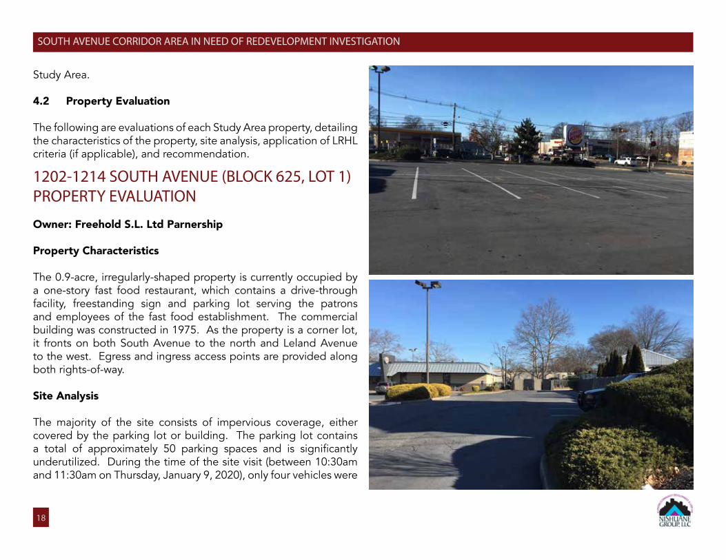
1202-1214 SOUTH AVENUE (BLOCK 625, LOT 1)PROPERTY EVALUATION
Owner: Freehold S.L. Ltd Parnership
Property Characteristics
The 0.9-acre, irregularly-shaped property is currently occupied by a one-story fast food restaurant, which contains a drive-through facility, freestanding sign and parking lot serving the patrons and employees of the fast food establishment. The commercial building was constructed in 1975. As the property is a corner lot, it fronts on both South Avenue to the north and Leland Avenue to the west. Egress and ingress access points are provided along both rights-of-way.
Site Analysis
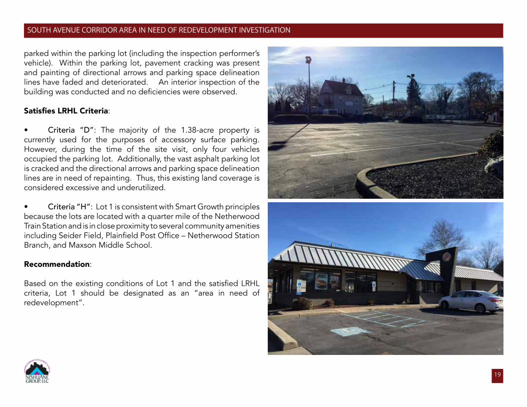
The majority of the site consists of impervious coverage, either covered by the parking lot or building. The parking lot contains a total of approximately 50 parking spaces and is significantly underutilized. During the time of the site visit (between 10:30am and 11:30am on Thursday, January 9, 2020), only four vehicles were
19
SOUTH AVENUE CORRIDOR AREA IN NEED OF REDEVELOPMENT INVESTIGATION
parked within the parking lot (including the inspection performer’s vehicle). Within the parking lot, pavement cracking was present and painting of directional arrows and parking space delineation lines have faded and deteriorated. An interior inspection of the building was conducted and no deficiencies were observed.
SatisfiesLRHLCriteria:
• Criteria “D”: The majority of the 1.38-acre property is currently used for the purposes of accessory surface parking. However, during the time of the site visit, only four vehicles occupied the parking lot. Additionally, the vast asphalt parking lot is cracked and the directional arrows and parking space delineation lines are in need of repainting. Thus, this existing land coverage is considered excessive and underutilized.
• Criteria “H”: Lot 1 is consistent with Smart Growth principles because the lots are located with a quarter mile of the Netherwood Train Station and is in close proximity to several community amenities including Seider Field, Plainfield Post Office – Netherwood Station Branch, and Maxson Middle School.
Recommendation:
Based on the existing conditions of Lot 1 and the satisfied LRHL criteria, Lot 1 should be designated as an “area in need of redevelopment”.
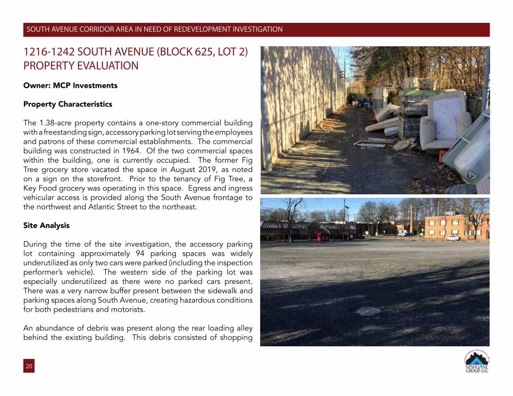
1216-1242 SOUTH AVENUE (BLOCK 625, LOT 2)PROPERTY EVALUATION
Owner: MCP Investments
Property Characteristics
The 1.38-acre property contains a one-story commercial building with a freestanding sign, accessory parking lot serving the employees and patrons of these commercial establishments. The commercial building was constructed in 1964. Of the two commercial spaces within the building, one is currently occupied. The former Fig Tree grocery store vacated the space in August 2019, as noted on a sign on the storefront. Prior to the tenancy of Fig Tree, a Key Food grocery was operating in this space. Egress and ingress vehicular access is provided along the South Avenue frontage to the northwest and Atlantic Street to the northeast.
Site Analysis
During the time of the site investigation, the accessory parking lot containing approximately 94 parking spaces was widely underutilized as only two cars were parked (including the inspection performer’s vehicle). The western side of the parking lot was especially underutilized as there were no parked cars present. There was a very narrow buffer present between the sidewalk and parking spaces along South Avenue, creating hazardous conditions for both pedestrians and motorists.
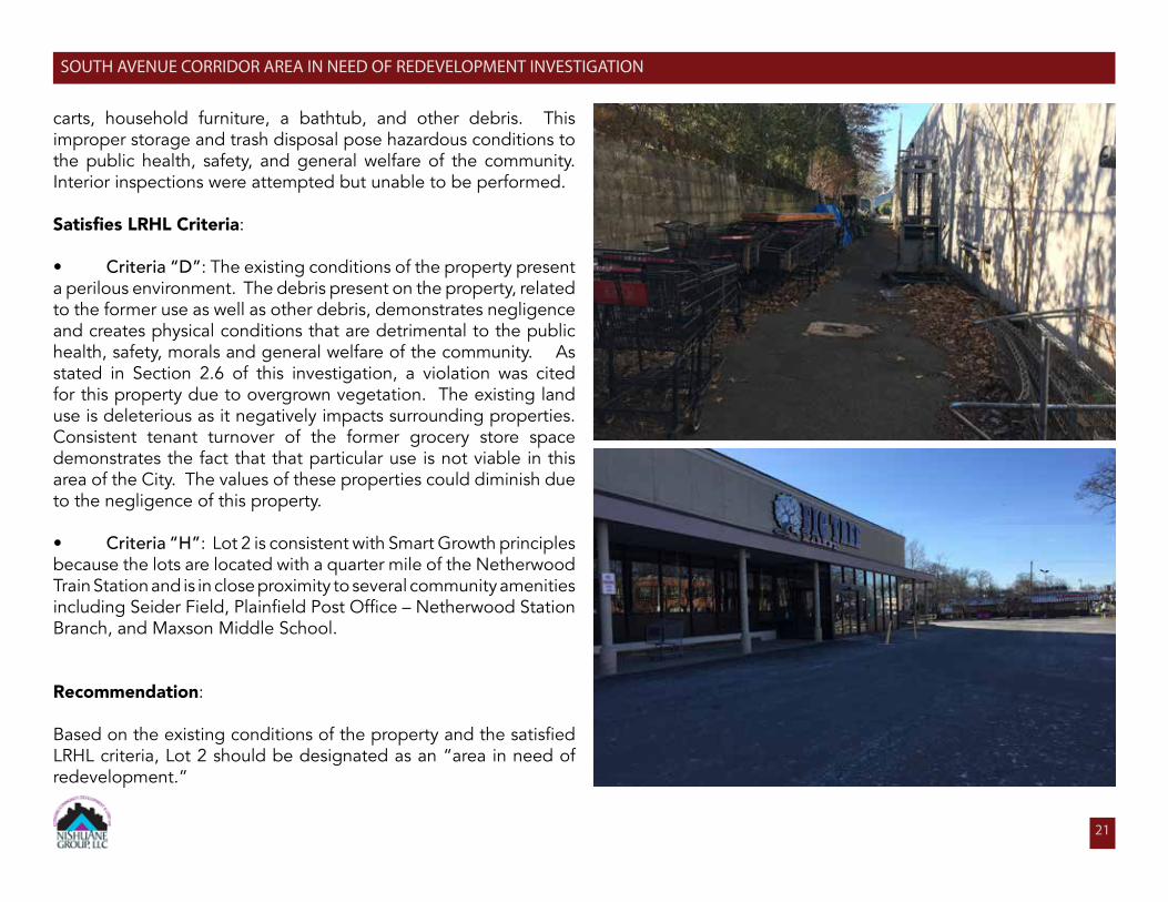
An abundance of debris was present along the rear loading alley behind the existing building. This debris consisted of shopping
20
SOUTH AVENUE CORRIDOR AREA IN NEED OF REDEVELOPMENT INVESTIGATION
21
SOUTH AVENUE CORRIDOR AREA IN NEED OF REDEVELOPMENT INVESTIGATION
carts, household furniture, a bathtub, and other debris. This improper storage and trash disposal pose hazardous conditions to the public health, safety, and general welfare of the community. Interior inspections were attempted but unable to be performed.
SatisfiesLRHLCriteria:
• Criteria “D”: The existing conditions of the property present a perilous environment. The debris present on the property, related to the former use as well as other debris, demonstrates negligence and creates physical conditions that are detrimental to the public health, safety, morals and general welfare of the community. As stated in Section 2.6 of this investigation, a violation was cited for this property due to overgrown vegetation. The existing land use is deleterious as it negatively impacts surrounding properties. Consistent tenant turnover of the former grocery store space demonstrates the fact that that particular use is not viable in this area of the City. The values of these properties could diminish due to the negligence of this property.
• Criteria “H”: Lot 2 is consistent with Smart Growth principles because the lots are located with a quarter mile of the Netherwood Train Station and is in close proximity to several community amenities including Seider Field, Plainfield Post Office – Netherwood Station Branch, and Maxson Middle School.
Recommendation:
Based on the existing conditions of the property and the satisfied LRHL criteria, Lot 2 should be designated as an “area in need of redevelopment.”
513-515 LELAND AVENUE (BLOCK 625, LOT 85)PROPERTY EVALUATION
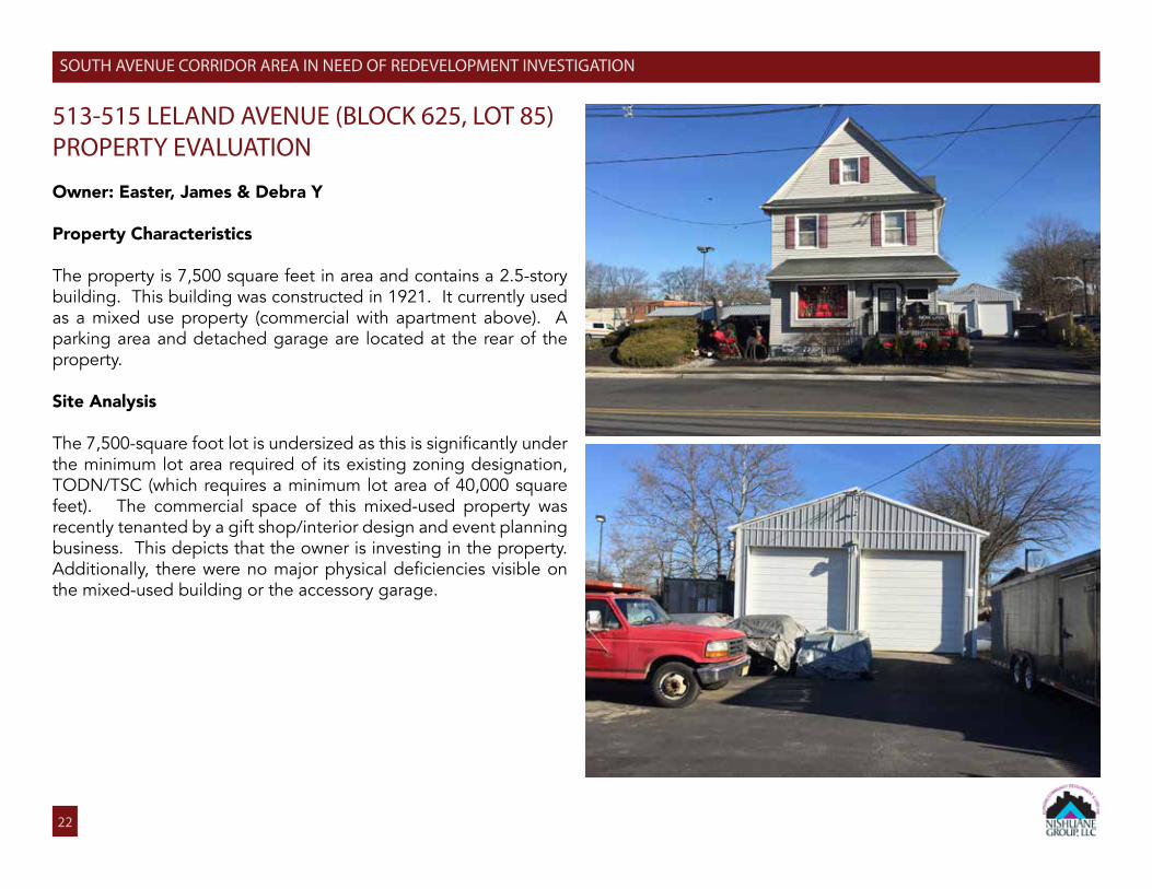
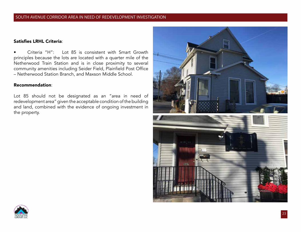
Owner: Easter, James & Debra Y
Property Characteristics
The property is 7,500 square feet in area and contains a 2.5-story building. This building was constructed in 1921. It currently used as a mixed use property (commercial with apartment above). A parking area and detached garage are located at the rear of the property.
Site Analysis
The 7,500-square foot lot is undersized as this is significantly under the minimum lot area required of its existing zoning designation, TODN/TSC (which requires a minimum lot area of 40,000 square feet). The commercial space of this mixed-used property was recently tenanted by a gift shop/interior design and event planning business. This depicts that the owner is investing in the property. Additionally, there were no major physical deficiencies visible on the mixed-used building or the accessory garage.
22
SOUTH AVENUE CORRIDOR AREA IN NEED OF REDEVELOPMENT INVESTIGATION
23
SOUTH AVENUE CORRIDOR AREA IN NEED OF REDEVELOPMENT INVESTIGATION
SatisfiesLRHLCriteria:
• Criteria “H”: Lot 85 is consistent with Smart Growth principles because the lots are located with a quarter mile of the Netherwood Train Station and is in close proximity to several community amenities including Seider Field, Plainfield Post Office – Netherwood Station Branch, and Maxson Middle School.
Recommendation:
Lot 85 should not be designated as an “area in need of redevelopment area” given the acceptable condition of the building and land, combined with the evidence of ongoing investment in the property.
24
PARK AVENUE GATEWAY AREA IN NEED OF REDEVELOPMENT INVESTIGATION
4.3. Findings
Based upon the analysis above, it can be concluded that Lots 1 and 2 meet several of the LRHL statutory criteria. It is suggested that the Plainfield Planning Board recommend that the City Council designate only Lots 1 and 2 as a Non-Condemnation Redevelopment Area based on the findings below:
Area In Need of Redevelopment Criteria
A: Criteria “A” does not apply to the Study Area properties.
B: Criteria “B” does not apply to the Study Area properties.
C: Criteria “C” does not apply to the Study Area properties.
D: Criteria “D” was applied to the Lots 1 and 2. Both properties are underutilized as accessory surface parking lots consume the majority of each property, presenting excessive land coverage. On Lot 1, the asphalt-covered parking lot is occupied by only a few cars. Thus, the lot is not being fully utilized for its intended purpose as demand for parking has shifted since the origination of this land use. On Lot 2, the existing conditions demonstrate signs of neglect and lack of maintenance as substantial debris is present and scattered along the rear of the property. Short-term grocery store turnover also shows that this use is not particularly well suited for this location.
E: Criteria “E” does not apply to the Study Area properties.
F: Criteria “F” does not apply to the Study Area properties.
G: Criteria “G” does not apply to the Study Area properties.
H: Criteria “H” was applied to Lots 1 and 2. In 2003, the LRHL was amended to include smart growth criteria which encouraged livable neighborhoods. It is a planning approach that directs new growth to locations where infrastructure and services are available, limits sprawl development, protects the environment, and enhances and rebuilds existing communities. The existing neighborhood, in which the Study Area is located, has public transportation options, surrounding mixed use development, open space and other City amenities. It lends itself to increase the intensity.
Section 3: Section 3 does not apply to the Study Area properties.
SOUTH AVENUE CORRIDOR AREA IN NEED OF REDEVELOPMENT INVESTIGATION
25
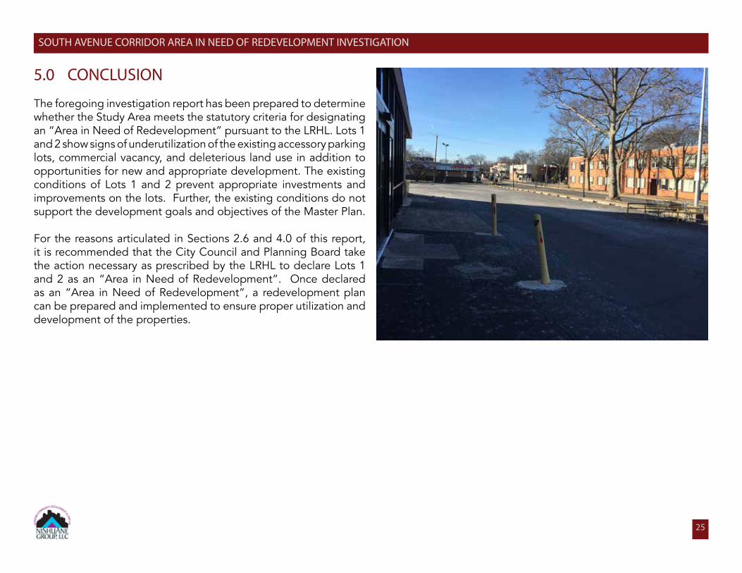
5.0 CONCLUSION
The foregoing investigation report has been prepared to determine whether the Study Area meets the statutory criteria for designating an “Area in Need of Redevelopment” pursuant to the LRHL. Lots 1 and 2 show signs of underutilization of the existing accessory parking lots, commercial vacancy, and deleterious land use in addition to opportunities for new and appropriate development. The existing conditions of Lots 1 and 2 prevent appropriate investments and improvements on the lots. Further, the existing conditions do not support the development goals and objectives of the Master Plan.
For the reasons articulated in Sections 2.6 and 4.0 of this report, it is recommended that the City Council and Planning Board take the action necessary as prescribed by the LRHL to declare Lots 1 and 2 as an “Area in Need of Redevelopment”. Once declared as an “Area in Need of Redevelopment”, a redevelopment plan can be prepared and implemented to ensure proper utilization and development of the properties.
SOUTH AVENUE CORRIDOR AREA IN NEED OF REDEVELOPMENT INVESTIGATION