Embed Size (px)
Citation preview
By taking action now we can significantly reduce future losses
from earthquakes.
Are you prepared forthe next big
in Alaska?
What to do during and after an earthquake
How to prepare for an earthquake
Assessing your risk from earthquakes
Preparing for tsunamis
Earthquakes in Alaska
Other souces of information

Alaska has changed significantly since the damaging 1964 earthquake, and the population has more than doubled. Many new buildings are designed to withstand intense shaking, some older buildings have been reinforced, and development has been discouraged in some particularly hazardous areas.
Despite these precautions, future earthquakes may still cause damage to buildings, displace items within buildings, and disrupt the basic utilities that we take for granted. We must take every reasonable action to prepare for damaging earthquakes in order to lower these risks.
Scientists have long recognized that Alaska has more earthquakes than any other region of the United States and is, in fact, one of the most seismically active areas of the world. The second-largest earthquake ever recorded shook the heart of southern Alaska on March 27th, 1964.
The largest strike-slip slip earthquake in North America in almost 150 years occurred on the Denali Fault in central Alaska on November 3rd, 2002. “Great” earthquakes (larger than magnitude 8) have rocked the state on an aver-age of once every 13 years since 1900. It is only a matter of time before another major earthquake will impact a large number of Alaskans.
Preparedness for earthquakes and other natural disasters is both a collective and an individual responsibility. As a society we have created agencies and organizations to assess, monitor, and respond to various threats from natural disasters. The Alaska Division of Homeland Security and Emergency Management (DHS&EM) is responsible for providing Alaskans with earthquake preparedness information and training. The office of the Alaska State Seismologist and the Alaska Earthquake Information Center (AEIC), the UAF Geophysical Institute (UAF-GI), the U.S. Geological Survey (USGS), the Alaska Division of Geological & Geophysical Surveys (ADGGS), and the NOAA West Coast/Alaska Tsunami Warning Center (WC/ATWC) work together to provide data and information to the public and to local, state, and federal authorities for use in earthquake hazard mitigation and response. This alliance of agencies carries out our collective effort to understand and prepare for earthquake disasters.
As individuals, we must also take steps to prepare for earthquakes in order to protect ourselves, our loved ones and our property. By identifying the greatest hazards to our personal safety, we can set priorities for using our resources in the most effective way to reduce possible damage. By becoming aware of the hazards posed by earthquakes and by taking appropriate actions, such as those described in this pamphlet, we can drastically reduce the loss of life and property, and make Alaska a safer place to live . . . the choice is ours.
Why you need to prepare for the next earthquake

DROP
COVER
HOLD
1
What to do during and after an earthquake
If you are indoors, drop to the fl oor and take cover under a sturdy desk, table or other furniture. Hold on to it and be prepared to move with it. Hold the position until the ground stops shaking and it is safe to move. Stay clear of windows, heavy wall hangings, fi replaces, woodstoves, and heavy furniture or appliances that may fall over. Stay inside to avoid being injured by falling glass or build-ing parts. It is diffi cult to stand up in a large earthquake and trying to walk would be even more diffi cult. Do not try to run out of the structure but instead drop, cover, and hold. Crouching against a sturdy wall with nothing above you and no windows nearby is an alter-native if there is not a table to get under. If you are in a crowded area, take cover where you are. Stay calm and encourage others to do likewise.
If you are outside, get into the open, away from buildings and power lines.
If you are driving, stop if it is safe but stay inside your car. Stay away from bridges, overpasses and tunnels. Move your car as far out of the normal traffi c pattern as possible. If possible, avoid stopping under trees, light posts, power lines, or signs.
If you are in a mountainous area, or near unstable slopes or cliffs, be alert for falling rock, snow, and other debris that could be loosened by the earthquake.
If you are near the ocean, move quickly to higher ground or move several hun-dred yards inland.
The fi rst reaction many people have dur-ing an earthquake is to run out of a building. This increases the likelihood that you will be hit by falling objects. Most earthquake related injuries in the United States occur in this way. In a large quake, falling objects can become
DON’T RUN OUTSIDE
projectiles that are diffi cult to avoid. The most serious injury sustained during the November 2002 Denali fault earthquake, occurred when a woman slipped and broke her arm while exiting her home.
In the past it was recommended that you stand in a doorway during an earthquake. This is not the best place to go because only one person can fi t in a doorway, and you won’t be protected from falling and fl ying objects. A woman was trapped in a doorway during the Denali fault earthquake when the door slammed shut on her hand. This not only injured her but also stopped her from taking cover from falling objects.
Update2_3_10_18.indd 1 3/10/04 3:27:39 PM

2
Check for injuries: Do not move a seriously injured person unless they are in immediate danger of further injuries.
Gas leaks: Shut off the main gas valve only if a leak is suspected or identifi ed by the odor of natural gas. Wait for the gas company to turn it back on after the damage is repaired.
Oil or propane tanks: If you have one, check that the supports are intact and that connecting pipes and hoses are not broken.
Downed or damaged chimneys:Approach chimneys with caution. They may be weakened and could topple dur-ing an aftershock.
Children and Earthquakes
Earthquakes are traumatic events for all of us, but they are especially frightening for children who may be forced to leave their homes and everything that is familiar to them. A child does not usually under-stand such events and feels anxious, con-fused, and frightened. Fear is a normal re-action to any danger which threatens life or well-being. After an earthquake, a child’s fears are those of recurrence, injury, death, or of being alone and separated from the rest of the family. Aftershocks can increase these fears.
Parents sometimes ignore the emo-tional needs of a child once assured of their physical safety. A child’s persistent fears may generate disruptive behavior, surpris-ing and frustrating a parent who is trying to continue with the daily family routine.
How a parent can help:
Keep the family together. This provides immediate reassurance to a child; fears of being abandoned and unprotected are alleviated.
Reassure children with words as well as actions. Emphasize the positive: “We are all to-gether and nothing has happened to us,” or “You don’t have to worry, we will look after you.”
Encourage the child to talk. It can also be helpful to include other family members, neigh-bors, and their children in a conversation about our reactions to the earthquake.
Include the child in family activities. There will be important concerns and things to do after an earthquake, such as checking on the damage and cleaning up broken glass and fallen furniture. Whenever possible, a child can and should be included in these activities.
At bedtime, a child may have diffi culty fall-ing asleep. They may wake up during the night or have nightmares for weeks or months after the earthquake. These situations may be dealt with by allowing the child to move into a room with an-other child or to sleep on a mattress in the parents’ room, or simply by a parent spending a little extra time in the child’s room giving reassurance.
Tsunami hazard: If you live along the coast, be alert for news of tsunami warnings issued by the Tsunami Warning Center or local community offi cials. If you experience a strong earthquake, there may not be time for a warning to be issued. Move to higher ground as soon as you can, and stay there until the authorities issue an “all clear.” Expect aftershocks: The only time that we know earthquakes will occur is after an-other large earthquake. Most aftershocks are smaller than the main earthquake. Some may be large enough to do additional damage to weakened structures.
Use fl ashlights or battery-powered lanterns. Do not use lighters, matches, candles, or lanterns until you are sure that there are no gas, propane or oil leaks. Use your telephone only in the event of life-threatening emergencies.
Turn on a battery or crank-powered radio for information, damage reports, and for information on volunteering your assistance.
Keep streets clear for emergency vehicles. Cooperate with public safety offi cials.
Damaged electrical wiring:Shut off power at the distribution panel or breaker box.
Downed or damaged utility lines:Stay away from downed lines even if power appears to be off.
Fallen objects in closets and cup-boards: Displaced objects may fall when you open the door.
Check your telephone: Make sure each phone is on its receiver. Telephones that are off the hook tie up the telephone network unnecessarily.
Clean up: Clean up potentially hazard-ous materials and/or medicines which may have spilled.
Safety check. Check for the following hazards
Update2_3_10_18.indd 2 3/10/04 3:27:43 PM
3
How to prepare for an earthquake
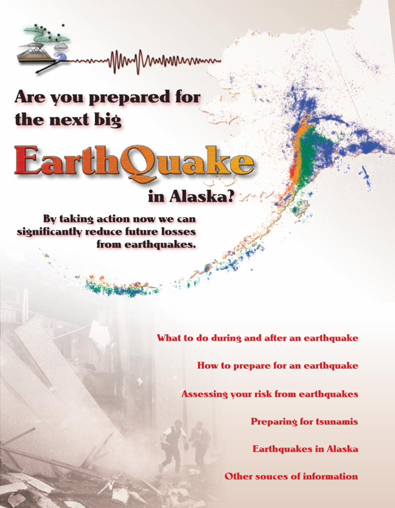
Most people in Alaska will survive the next big earthquake with little loss. Some people may be severely affected. Actions you take now can reduce how much you and your family will lose.
Practice “drop, cover, and hold” drills at home with your fam ily, and at work. q Injuries and deaths during earth-quakes are caused by falling objects and collapsing structures. Knowing how to protect yourself when the shaking starts may save your life. Show children safe areas to drop, cover and hold. q Practice counting to sixty seconds. Most earthquakes do not last that long, and it will help you to keep calm when a real earthquake strikes. Develop an earthquake plan at home, in your neighborhood, at school, and at work.q Determine the safest places in your home and at work. These should be
away from heavy furniture or appliances, woodstoves, fi replaces, open shelves and book-cases, and large panes of glass, pictures, or mirrors.
q If the earthquake hits during the day, family members may be separated from several hours to several days. Plan ahead and select a safe place where you can reunite after the earthquake. Con-sider your family’s possible needs, and also select alternative locations to meet near places of work or school.
q Designate an out-of-the-area telephone contact. Select a relative or friend to act as a clearinghouse for information about your family. Family members should call this contact person to report their condition and location. Make sure family members carry this number with them at all times, and that the number is known by other friends and relatives.
q The most common cause of earthquake-related fi res is broken gas lines. Everyone should know how to turn off the gas supply at the meter in case they smell gas after a large earthquake. Buy a special wrench that fi ts your gas turnoff valve and fasten it next to the valve.
q Find out the policy of your local school concerning the release of children after an earthquake. Arrange with neigh-bors to watch out for your family and property in case you are not at home.
q Make plans with your family, your neighbors, and your co-workers. Every business should have an emergency re-sponse plan.
Pick two places to meet.
(1) Right outside your home. (2) Outside your neighborhood in case you are not able to return home. Everyone must know the address and telephone number.
Ask an out-of-state friend to be your “family contact.”
q After a disaster, it’s often easier to place a long distance telephone call than a local one. Other family members should call this person and tell them where they are. Everyone must know your contact’s phone number.
Family Disaster Plan
Emergency Meeting Place outside your home
Meeting Place outside your neighborhood
Phone
Address
Family Contact
Phone ( ) day
Phone ( ) evening
Update2_3_10_18.indd 3 3/10/04 3:27:45 PM
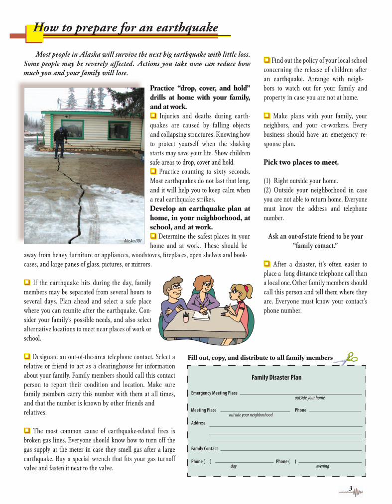
Keep enough supplies in your home to meet your needs for at least seven days. Store these items in sturdy, easy-to-carry containers such as backpacks, duffel bags, or covered trash containers. These are the basics to have on hand for any emergency:
Emergency Broadcasts after an Earthquake
Waiting for the dissemination of infor-mation after a disaster takes time and can prove frustrating when we want, and have come to expect, immediate and complete in-formation. Search the radio and television channels to fi nd stations that are able to pro-vide information. Remember that initial news reports may be inaccurate. Don’t believe ev-erything you hear. Pay particular attention to information from a governmental source.
The fi rst information about a large local earthquake may come from the Alaska Earthquake Information Center, the USGS, the State of Alaska Deptartment of Geological & Geophysical Surveys or from the West Coast/Alaska Tsunami Warning Center (web links printed on page 23). Initial estimates of location and magnitude of an earthquake are likely to be revised as more information is analyzed.
Initial reports of damage, based primar-ily on eyewitness accounts, may be mislead-ing and cause speculation. Local news-gather-ing capabilities may be severely hindered by the disaster, because the news media’s power may be off or their news staff may be unable to communicate with their broadcast station.
4
Emergency supplies list
Flashlights with spare batteries: Keep a fl ashlight beside your bed. Do not use matches or candles after an earth quake until you are certain no gas leaks exist.
Hand-crank or battery-operated radio with spare batteries:Most telephones will be out of order or in use for emergency purposes, so radios will be your best source of information. An automobile radio is a good substitute.
First aid kit and fi rst aid knowledge: Have a fi rst aid book such as Standard First Aid & Personal Safety by the American Red Cross. Have members of your household take basic Red Cross fi rst aid and CPR courses.
Fire extinguisher: Keep a fi re extinguisher handy for small fi res. Some extinguishers are only good for certain types of fi res--electrical, grease, or gas. Class ABC extinguishers are designed to be used safely on any type of fi re.
Food: It’s a practical idea to keep a supply of non-perishable food on hand that can be rotated into your diet and replenished on a regular basis. Have a supply of canned or dehydrated food, powdered milk, and canned juices that is suffi cient for at least seven days. Water: Water should be stored in airtight containers and replaced every six months. Store at least three gallons per person. For water not treated by a com-mercial facility, add 16 drops or 1/4 teaspoon of household bleach per gallon of water. Stir and let stand for 30 minutes. Use bleach which has 5.25% hypochlorite as the only active ingredient, with no fragrance and soap additives. Do not store in used plastic milk containers because bacteria may be present.
Warm clothes and blankets: Have enough warm clothes, blankets, and sleeping bags to survive sub-zero winter temperatures. If possible store these items outside of the home so they will be accessible after a rapid evacuation.
Special items: Keep at least one week’s supply of medications and special foods on hand that are needed for infants or for those on limited diets.
Tools: Have a pipe wrench and an adjustable wrench for turning off gas and water mains.
Update2_3_10_18.indd 4 3/10/04 3:27:48 PM
Falling objects and toppling furniture present the greatest physical danger and the biggest potential fi nancial loss for most people. Imagine all of the contents of your kitchen cabinets falling to the fl oor or on your head! At home, at work, and in schools, building contents should be secured.
Guardrails,chains, ora small lipwill helpkeepobjectsfromsliding offopenshelves.
Anglebracket
Foundation
Wallstud
If present, reinforce the “cripple walls” tosignificantly reduce earthquake damage.Nail plywood panels with drilled ventilationholes to each stud using 8d nails .
Many houses do not have enoughfoundation bolts. Use expansion-type or epoxy-type bolts.
Cripple wall
Existing sill
Install positivecatching latcheson cabinet doors.
Screw hooks intowood membersonly (stud or ceilingjoints). Close hooksused for hangingpictures to preventtheir falling.
Closehook
Wallstud
Sheetrock
1/4" X 3"lag screw
Wallstud
Tall furniture such asbookshelves should bebolted against the wallwith metal "L" brackets.
Remove top ofunreinforcedmasonrychimneys andreplacewith metal flue.
Existing sill
q Be sure that no heavy items, such as pic-tures or mirrors, can fall on your bed, where you typically spend a third of each day.
q Secure tall furniture and bookcases to the wall. Add lips to shelves to prevent costly items from sliding off. Be sure that adjustable shelves cannot slide off their supports.
q Put strong latches on cabinet doors at home in your kitchen and at work in labora-tories. Fasten heavy or precious items to shelves or tables. Secure fi le cabinets, com-puters, televisions, and machinery that may overturn during an earthquake.
q Store potentially hazardous materials such as cleaners, fertilizers, chemicals, and petroleum products in appropriate contain-ers in sturdy cabinets that are fastened to the wall or fl oor.
q In your offi ce, be sure heavy objects are fastened to the building structure and not just to a movable wall. Ask a carpenter or an electrician to check light fi xtures and modular ceiling systems.
q Be sure your water heater is fastened to the wall studs and that all gas heaters and appliances are connected to the gas pipe through fl exible tubing. If you use propane or heating oil, be sure the storage tank is secured against overturning and sliding.
q Secure your woodstove to wall or fl oor studs. Make sure you have a fi re extin-guisher close at hand.
q Check with your school offi cials to be sure they have taken similar precautions in your childrens’ school buildings.
Many specialty earthquake fasteners are commercially produced. Check with your hardware store for products, or ask your local emergency management offi ce for the names of products and vendors. Search-ing the Internet for “earthquake fasteners”will also yield many results. The web site of the Federal Emergency Manage-ment Agency, www.fema.gov, con-tains much information about preparing for earthquakes. Go to the “Preparation and Prevention” section of the Library.
Modifi ed from a
McClatchy News Service Diagram
B
B
A
C
5
Protect your belongings
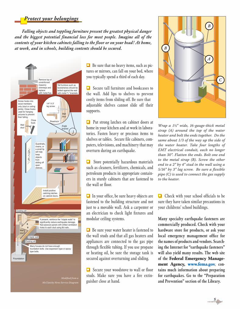
Wrap a 1½” wide, 16-gauge-thick metal strap (A) around the top of the water heater and bolt the ends together. Do the same about 1/3 of the way up the side of the water heater. Take four lengths of EMT electrical conduit, each no longer than 30”. Flatten the ends. Bolt one end to the metal strap (B). Screw the other end to a 2” by 4” stud in the wall using a 5/16” by 3” lag screw. Be sure a fl exible pipe (C) is used to connect the gas supply to the heater.
Update2_3_10_18.indd 5 3/10/04 3:27:50 PM
������� �������������
��������������������������������������
����������������� ������������������������ ����������������
6
Fuel tank supports and earthquakes
The use of raised fuel tanks, to provide gravity fl ow to oil heaters, is common throughout Alaska. During the De-nali Fault earthquake on November 3rd, 2002, several 300 gallon fuel tanks tipped off or slid from their supports, demonstrating their vulnerability. By strengthening fuel tank supports and connectors to withstand ground shaking, the
risk of damage, hazardous spills, and the loss of heating oil can be reduced. Once the structure is built, regular inspection is recommended to ensure structural integrity.
A wood support is vulnerable to damage due to deterioration or inadequate cross-bracing and fastening. It should be inspected for rot damage, and any deteriorating wood supports should be replaced. Existing wood supports with cross-bracing, or insuffi cient bracing, should have diagonal bracing and gussets added to strengthen the support. Utilizing wood-to-wood con-necting plates, bolts, lag screws, and nails can help to reduce vulnerability, but their effective-ness is limited by the tendency of wood fi bers to split and tear when subjected to large loads.
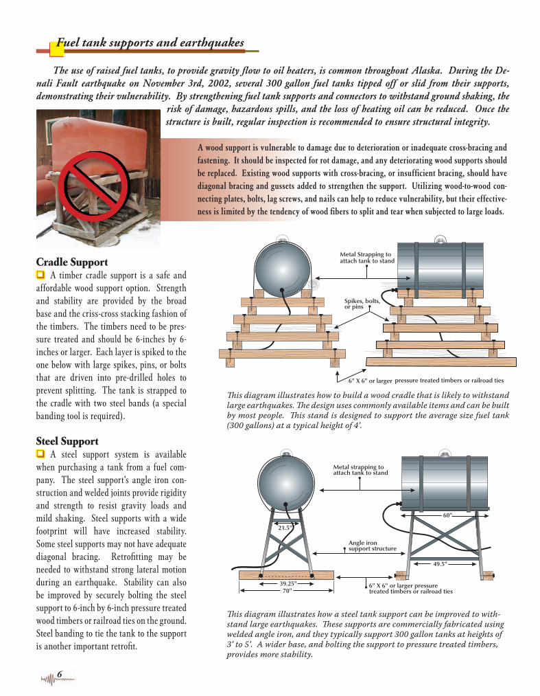
Th is diagram illustrates how to build a wood cradle that is likely to withstand large earthquakes. Th e design uses commonly available items and can be built by most people. Th is stand is designed to support the average size fuel tank (300 gallons) at a typical height of 4’.
Cradle Supportq A timber cradle support is a safe and affordable wood support option. Strength and stability are provided by the broad base and the criss-cross stacking fashion of the timbers. The timbers need to be pres-sure treated and should be 6-inches by 6-inches or larger. Each layer is spiked to the one below with large spikes, pins, or bolts that are driven into pre-drilled holes to prevent splitting. The tank is strapped to the cradle with two steel bands (a special banding tool is required).
Steel Supportq A steel support system is available when purchasing a tank from a fuel com-pany. The steel support’s angle iron con-struction and welded joints provide rigidity and strength to resist gravity loads and mild shaking. Steel supports with a wide footprint will have increased stability. Some steel supports may not have adequate diagonal bracing. Retrofi tting may be needed to withstand strong lateral motion during an earthquake. Stability can also be improved by securely bolting the steel support to 6-inch by 6-inch pressure treated wood timbers or railroad ties on the ground. Steel banding to tie the tank to the support is another important retrofi t.
�����
���
���������
�����
��������������������������������������
���������������������������
����������������������������������������������������������
Th is diagram illustrates how a steel tank support can be improved to with-stand large earthquakes. Th ese supports are commercially fabricated using welded angle iron, and they typically support 300 gallon tanks at heights of 3’ to 5’. A wider base, and bolting the support to pressure treated timbers, provides more stability.
Update2_3_10_18.indd 6 3/10/04 3:27:52 PM
7
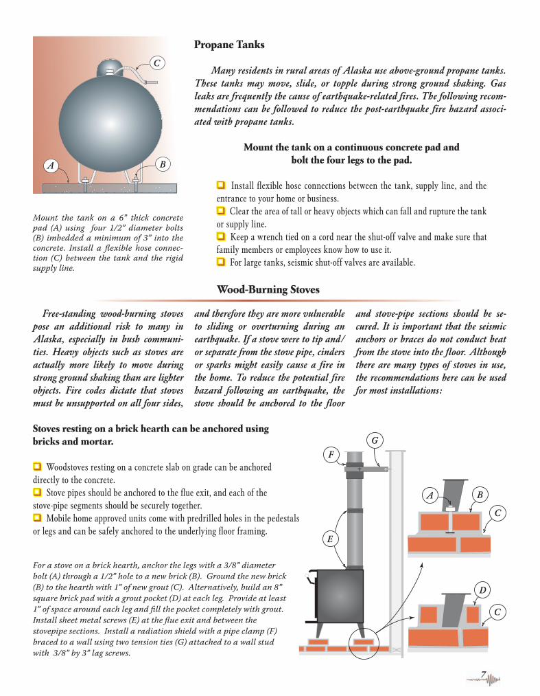
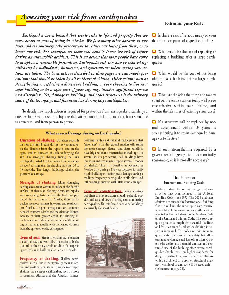
For a stove on a brick hearth, anchor the legs with a 3/8” diameter bolt (A) through a 1/2” hole to a new brick (B). Ground the new brick (B) to the hearth with 1” of new grout (C). Alternatively, build an 8” square brick pad with a grout pocket (D) at each leg. Provide at least 1” of space around each leg and fi ll the pocket completely with grout. Install sheet metal screws (E) at the fl ue exit and between the stovepipe sections. Install a radiation shield with a pipe clamp (F) braced to a wall using two tension ties (G) attached to a wall stud with 3/8” by 3” lag screws.
Mount the tank on a continuous concrete pad and bolt the four legs to the pad.
q Install fl exible hose connections between the tank, supply line, and the entrance to your home or business. q Clear the area of tall or heavy objects which can fall and rupture the tank or supply line. q Keep a wrench tied on a cord near the shut-off valve and make sure that family members or employees know how to use it. q For large tanks, seismic shut-off valves are available.
Mount the tank on a 6” thick concrete pad (A) using four 1/2” diameter bolts (B) im bedded a minimum of 3” into the concrete. Install a fl exible hose connec-tion (C) between the tank and the rigid supply line.
q Woodstoves resting on a concrete slab on grade can be anchored directly to the concrete.q Stove pipes should be anchored to the fl ue exit, and each of the stove-pipe segments should be securely together. q Mobile home approved units come with predrilled holes in the pedestalsor legs and can be safely anchored to the underlying fl oor framing.
Stoves resting on a brick hearth can be anchored using bricks and mortar.
Wood-Burning Stoves
Free-standing wood-burning stoves pose an additional risk to many inAlaska, especially in bush communi-ties. Heavy objects such as stoves are actually more likely to move during strong ground shaking than are lighter objects. Fire codes dictate that stoves must be unsupported on all four sides,
and therefore they are more vulnerable to sliding or overturning during an earthquake. If a stove were to tip and/or separate from the stove pipe, cinders or sparks might easily cause a fi re in the home. To reduce the potential fi re hazard following an earthquake, the stove should be anchored to the fl oor
and stove-pipe sections should be se-cured. It is important that the seismic anchors or braces do not conduct heat from the stove into the fl oor. Although there are many types of stoves in use, the recommendations here can be used for most installations:
Many residents in rural areas of Alaska use above-ground propane tanks. These tanks may move, slide, or topple during strong ground shaking. Gas leaks are frequently the cause of earthquake-related fi res. The following recom-mendations can be followed to reduce the post-earthquake fi re hazard associ-ated with propane tanks.
Propane Tanks
Update2_3_10_18.indd 7 3/10/04 3:27:55 PM
8
Assessing your risk from earthquakes
Earthquakes are a hazard that create risks to life and property that we must accept as part of living in Alaska. We face many other hazards in our lives and we routinely take precautions to reduce our losses from them, or to lower our risk. For example, we wear seat belts to lower the risk of injury during an automobile accident. This is an action that most people have come to accept as a reasonable precaution. Earthquake risk can also be reduced sig-nifi cantly by individuals, businesses, and governments when appropriate ac-tions are taken. The basic actions described in these pages are reasonable pre-cautions that should be taken by all residents of Alaska. Other actions such as strengthening or replacing a dangerous building, or even choosing to live in a safer building or in a safer part of your city may involve signifi cant expense and disruption. Yet, damage to buildings and other structures is the primary cause of death, injury, and fi nancial loss during large earthquakes.
To decide how much action is required for protection from earthquake hazards, you must estimate your risk. Earthquake risk varies from location to location, from structure to structure, and from person to person.
q Is there a risk of serious injury or even death for occupants of a specifi c building?
q What would be the cost of repairing or replacing a building after a large earth-quake?
q What would be the cost of not being able to use a building after a large earth-quake?
q What are the odds that time and money spent on preventive action today will prove cost-effective within your lifetime, and within the lifetimes of existing structures?
q If a structure will be replaced by nor-mal development within 10 years, is strengthening it to resist earthquake dam-age cost-effective?
q Is such strengthening required by a governmental agency, is it economically reasonable, or is it morally necessary?
Estimate your Risk
Duration of shaking. Duration depends on how the fault breaks during the earthquake, on the distance from the rupture, and on the types and thicknesses of soils underlying the site. The strongest shaking during the 1964 earthquake lasted 3 to 4 minutes. During a mag-nitude 7 earthquake, the shaking may last 30 to 40 seconds. The longer buildings shake, the greater the damage.
Strength of shaking. Many damaging earthquakes occur within 15 miles of the Earth’s surface. In this case, shaking decreases rapidly with increasing distance from the fault that pro-duced the earthquake. In Alaska, these earth-quakes are most common in central and southeast-ern Alaska. Deeper earthquakes are common beneath southern Alaska and the Aleutian Islands. Because of their greater depth, the shaking di-rectly above such shocks is reduced, and the shak-ing decreases gradually with increasing distance from the epicenter of the earthquake.
Type of soil. Strength of shaking is greater on soft, thick, and wet soils. In certain soils the ground surface may settle or slide. Damage is typically less in buildings located on bedrock.
Frequency of shaking. Shallow earth-quakes, such as those that typically occur in cen-tral and southeastern Alaska, produce more rapid shaking than deeper earthquakes, such as those in southern Alaska and the Aleutian Islands.
Buildings with a natural shaking frequency that “resonates” with the ground motion will suffer the most damage. Houses and short buildings have high resonant frequencies of shaking (1 to several shakes per second), tall buildings have low resonant frequencies (up to several seconds per shake). Thus it is possible, as occurred in Mexico City during a 1985 earthquake, for mid-height buildings to suffer great damage during a medium-frequency earthquake, while short and tall buildings survive with little or no damage.
Type of construction. Some existing buildings are not resistant enough to the side-to-side and up-and-down shaking common during earthquakes. Un-reinforced masonry buildings are usually the most deadly.
What causes Damage during an Earthquake?
The Uniform or International Building Code
Modern criteria for seismic design and con-struction have been included in the Uniform Building Code since 1973. The 2000 and later editions are termed the International Building Code, and have the most up-to-date require-ments. Most large communities in Alaska have adopted either the International Building Code or the Uniform Building Code. The codes re-quire greater strength for essential facilities and for sites on soft soil where shaking inten-sity is increased. The codes set minimum re-quirements that assure life safety but allow earthquake damage and loss of function. Own-ers who desire less potential damage and con-tinued use of the building after severe earth-quakes should insist on higher standards for design, construction, and inspection. Discuss with an architect or a civil or structural engi-neer what level of damage will be acceptable(references on page 24).
Update2_3_10_18.indd 8 3/10/04 3:27:58 PM
���� � �����
��� �
����
���������������������������������������
��� � ��� � ��� �
0 50 100km
���
�������������������
������
��������������������������������
����������������������������
� �� ��� ����������
�� ������
���� � ���� � ���� � ���� � ���� � ���� � ���� � ���� � ���� �
���
���
���
���
���
������������������
���
��������������� ��������
��������������� ��������
��
��
��
��
��
��
���������
��� �����
��������
���������
������
������
INSTRUMENTAL INTENSITY
POTENTIAL DAMAGE
PERCEIVED SHAKING
I II-III IV V VI VII VIII IX X+none none none Very light Light Moderate Moderate/Heavy Heavy Very Heavy
Not felt Weak Light Moderate Strong Very strong Severe Violent Extreme
For more information, go online to www.aeic.alaska.edu, www.dggs.dnr.state.ak.us and earthquake.usgs.gov
9
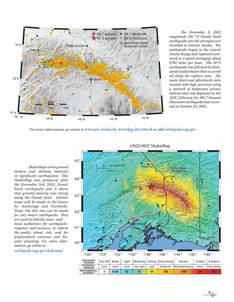
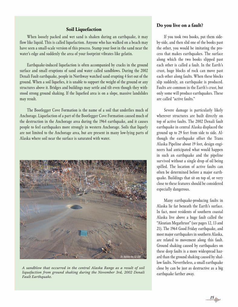
ShakeMaps show ground motion and shak ing intensity in signi fi cant earthquakes. Th is ShakeMap was produced after the November 3rd, 2002, Denali Fault earth quake and it shows that ground shaking was strong along the Denali fault. Similar maps will be made in the future for Anchor age and Fair banks. Maps like this one can be made for any major earth quake. Th ey are used by federal, state, and local authorities for earthquake response and recovery, to informthe public about risk, and for preparedness ex ercises and dis-aster planning. For more infor-mation, go online toearthquake.usgs.gov/shakemap/
Th e November 3, 2002 magnitude (M) 7.9 Denali Fault earth quake was the strongest ever recor ded in interior Alaska. Th e earth quake began in the central Alaska Range and ruptured east-ward at a speed averaging about 6700 miles per hour. Th e M7.9 earthquake was followed by thou-sands of after shocks that oc curred all along the rupture zone. Th e main shock and after shocks were located with high precision using a network of tem porary seismic stations that was deployed by the AEIC follow ing the M6.7 Ne nana Mountain earth quake that occur-red on October 23, 2002.
Update2_3_10_18.indd 9 3/10/04 3:28:38 PM

Th e J.C. Penny building in downtown Anchorage was heavily damaged during the 1964 Good Friday earthquake.
10
Determine the safety of your home and school
Most people in Alaska are safe at home if they live in a one or two-story wood-frame building. These buildings are not likely to collapse during earthquakes. The most common damage is light cracking of interior walls, cracking of masonry chimneys, and cracking and possible collapse of brick or masonry veneer on exterior walls. A cracked chimney should be inspected by a qualifi ed professional before the woodstove or fi replace is used.
Unfortunately, some one- or two-story wood-frame buildings can be hazardous. Buildings that are not adequately bolted to their foundation may fail at or near ground level. Adding foundation bolts and bracing cripple walls found in some older homes, can vastly reduce the earthquake risk (see page 14). Correcting these problems will vastly reduce the earthquake risk for most residents. For many homes, additional brac-ing of water heaters, propane tanks, or oil tanks is an important retrofi t that should be completed (see pages 5, 6, and 7). Mod-ern elementary and high school buildings have generally performed well during earthquakes, with the exceptions of the Government Hill School and West High School in Anchorage in the 1964 earth-quake. The old Government Hill School was built on unstable soils and probably could not have been engineered to survive the massive landslide that occurred in
1964. The new Government Hill School is built on more stable soils farther from the bluff. Knowledge about proper seismic de-sign and where to locate buildings has in-creased dramatically since 1964, however, older school buildings may need to be reas-sessed in light of modern building codes.Mobile homes, portable classrooms, and
modular buildings can slide or bounce off their foundations during earthquakes. Their supports need to be braced to resist vertical and horizontal forces. If portable classrooms are used at your local school, you should ask school offi cials whether they are properly braced.
Much of the damage during the 1964 Good Friday earthquake in Anchorage resulted from landslides, such as this one beneath the old Government Hill Elementary School.
Buildings designed and constructed ac-cording to modern codes have generally performed very well during earthquakes. However, certain types of buildings, espe-cially older ones, are potentially hazardous. Unreinforced brick buildings pose a particu-lar hazard even in moderate earthquakes. Unbraced railings and walls inadequately anchored to the fl oors and roof can topple onto sidewalks or adjacent buildings.
Major damage often occurs in build-ings with a “soft” fi rst story. Usually, soft stories consist of an open space with stand-alone columns rather than interior walls supporting the building above. Such spaces are usually used as garages, stores, or large
offi ces. The fi rst fl oor does not have enough strength to resist the horizontal shaking force of the upper parts of the building. Similarly, rooms added over garages of private homes or older split-level homes may not be adequately supported.
Damage to all of these types of build-ings poses a threat to both life and property during earthquakes. These losses can be signifi cantly reduced by strengthening structures before an earthquake. Investment in strengthening offi ces and commercial buildings will reduce structural and non-structural damage and may allow continua-tion of business after severe earthquakes.
Determine the safety of other buildings you use
Update2_3_10_18.indd 10 3/10/04 3:28:40 PM

Civil and structural engineers and architects are trained and licensed to provide such information about structures. Geologists, foundation engineers, and geotechnical engineers are trained and licensed to evaluate the soil conditions and recommend ap-propriate action. When hiring such a consultant, you are asking an experienced professional to review a potential problem and possibly to provide plans and specifi ca-tions for correcting the problem. The amount of work required is not known when you hire the con-sultant, and thus it is important to select someone you trust, and to develop a scope of work as you proceed. A good place to start is to call a profes-sional organization (refer to the Other Sources of Information section at the back of this pamphlet) and ask for information about the different types of work that might be required, for information about
how to select an engineer, geologist, or architect, and for a list of members in your area. Contact sev-eral fi rms or individuals to determine if they do the different types of work you need. Ask for information that explains the type of fi rms they are and that identifi es others whom they have served. Check to see how satisfi ed other clients were. Recognize that the quality of the advice given and of the work per-formed, as well as the price you pay, may depend critically on the care you take in making a selection. Become informed. Even if you do not understand the technical details, ask enough questions to un-derstand the concepts and relative importance of the issues involved. Do not be afraid to ask ques-tions that you fear might appear foolish. Your money is going to be expended and your life and belongings are at risk, so you have a right to understand what needs to be done and why.
For projects more complex than inspecting a single-family home, you should meet with the selected fi rm and discuss the options. In almost every case, there will be a number of approaches for solving any given problem. Get the consultant to explain the pros and cons of each, as well as the dollars and risks in-volved. Once this is done, you will have defi ned the work the consultant will do for you. Then a fee can be set and you can discuss how changing the work would change the fee. State and federal agencies do not inspect individ-ual buildings. Your local building department may be willing to inspect your building, but they are not authorized to recommend actions to be taken.
Earthquake Insurance Standard homeowners insurance does not cover damage and destruction that happens as a result of an earthquake. Many people are unaware that their existing fi re insurance does not cover fi res caused by earthquakes. The 1989 Loma Prieta earthquake in California caused over 6 billion dollars in damage, but insured property damage accounted for only 16% of this loss. In Alaska, about 1 in 3 home-owners have purchased earthquake insurance. The most common type of earthquake insur-ance is normally added as an endorsement on a standard homeowner’s insurance policy. Typically, there is a deductible of 10 percent of the value of the home. This means that for a home currently insured at $200,000 you would have to pay $20,000 in damages before the insurance company would pay anything. Sepa-rate deductibles may apply to the contents of the house and the structure. Another impor-tant coverage is temporary living expense, which pays for motel and meals if you have to move out of your home. There is usually no deductible on this coverage. The yearly cost of residential earthquake insurance is normally about $3.00 per $1,000 of coverage on a con-ventional frame home. However the rate may rise to $13 per $1,000 of coverage on structures with brick or masonry veneer on the outside. Clearly, the insurance industry considers homes with brick or masonry to be a greater risk in an earthquake. Thus far, homeowners insurance carriers do not consider whether the soils you live on are potentially dangerous. To fi nd out more about earthquake insurance, ask your insurance agent.
An un-reinforced masonry building in Anchorage collapsed during the 1964 Good Friday earthquake.
11
If you believe a structure that you or your family uses is hazardous and you would like to fi nd out more or determine who you can consult, refer to the Other Sources of Information section at the back of this pam-phlet. Ask the building owner what consid-eration has been given to seismic design and strengthening. Many civil and structural engineers and architects are trained and li-censed to investigate the strength of a struc-ture and to recommend appropriate action to reduce earthquake risk.
How do you locate a professional to advise you on the resistance of your building to earthquake shaking?
For single-family homes, ask a licensed engineer or architect to look at your home while you are present and to discuss the seismic issues with you. A written report, or plans and specifi cations for corrective action, may involve more time. You may want to ask for a seismic inspection before buying a new home.
Update2_3_10_18.indd 11 3/10/04 3:28:43 PM

U.S. DEPARTMENT OF THE INTERIORU.S. GEOLOGICAL SURVEY
12 13
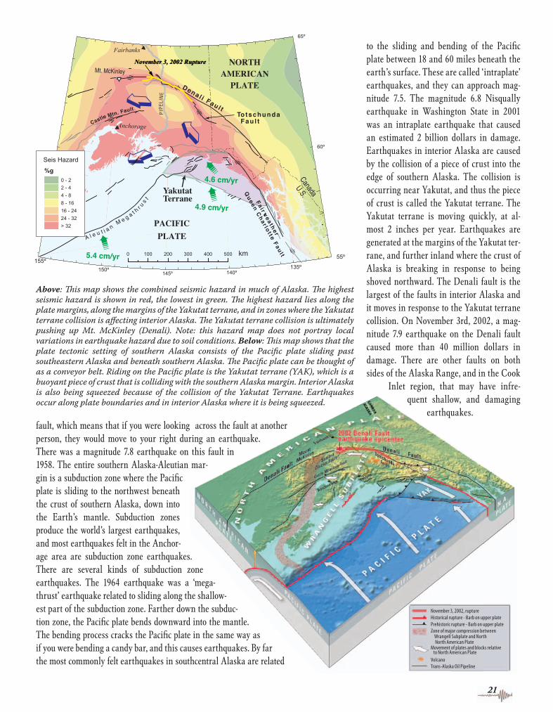
Earthquakes in AlaskaEarthquake risk is high in much of the southern half of Alaska, but it is not the same everywhere. This map shows the overall geologic setting in Alaska that produces earthquakes. The Pacifi c plate is sliding northwestward past southeastern Alaska and then dives beneath the North American plate in southern Alaska, the Alaska Peninsula, and the Aleutian Islands. Most earthquakes are produced where these plates come into contact and slide past each other. Major earthquakes also occur throughout much of interior Alaska as a result of collision of a piece of crust with the southern margin.
This piece of crust is being pushed into and beneath the southern Alaska margin. As a result it causes large earthquakes here and throughout interior Alaska.
The 1964 earthquake was the second largest ever recorded in the world. The area within this yellow patch slipped seaward up to 66 feet.
A Fault beneath a fold in Cook Inlet resulted in a M 7 earthquake in 1933 that strongly shook Anchorage.
The Queen Charlotte-Fairweather fault presents the greatest earthquake hazard to residents of southeast Alaska.
The Denali fault generated a M 7.9 earthquake in 2002. This part of the fault ruptured, with horizontal offset of up to 29 feet.
Three M 7 earthquakes occurred within 50 miles of Fairbanks in the last 90 years.
M 6.0 - 6.9
M 7.0 - 7.9
M 8.0 - 8.4
M 8.5 - 8.9
M 9.0 or larger
Pre-1964 Earthquakes
Post-1964 Earthquakes
EQ Magnitudes (M)
1964
Earthquake rupture zone and date of most recent rupture
Active and potentially active faults
Speed and direction of Pacifi c plate movement by and under Alaska.
This map is preliminary and has not been reviewed for conformity
with U.S. Geological Survey editorial standards or the North
American Stratigraphic Code. Any use of trade, product, or fi rm names is for descriptive purposes only and does not
imply endorsement by the U.S. Government.
This map is modifi ed from “Earthquakes in Alaska”by Peter Haeussler and George Plafker, U.S. Geological Survey Open File Report 95-624http://geopubs.wr.usgs.gov/open-fi le/of95-624/
Update2_3_10_18.indd 12-13Update2_3_10_18.indd 12-13 3/10/04 3:38:11 PM3/10/04 3:38:11 PM

14
Determine if you live or work in hazardous areas
About 75 homes in the Turnagain Heights area of Anchorage were destroyed in 1964 by a massive landslide. Th is area is underlain by soil that fl ows like water when it is shaken.
Earthquake damage is typically concentrated in areas that can be iden-tifi ed in advance. The amount of shaking experienced in an earthquake can be very different in locations less than a hundred yards apart. Deter-mine for yourself if the places where you live and work are particularly dangerous. Asking the questions on the following pages, and seeking the answers, is an excellent start.
Landslides are likely to be triggered by signifi cant earthquakes, especially on steep slopes and in areas underlain by soft ground. During the 1964 Alaskan earth-quake, much of the Turnagain Heights area of Anchorage slid toward Knik Arm because the area is underlain by a kind of soft, wet clay that is prone to sliding if shaken vio-lently. The clay in the Anchorage area and other types of soft ground can also intensify the shaking of an earthquake.
Fortunately, most areas that can settle, slide, or shake violently can be identifi ed before the next major earthquake. Even rea-sonably detailed maps give only an overview of the potential for shaking, liquefaction, landslides, faulting, and damage. To investi-gate a particular building site, you should consult an engineering geologist, geotechni-cal engineer, or a foundation engineer.
Th is is a map of the Anchorage area showing the relative chances of earthquake-induced ground failure in diff erent locations. If the ground “fails” during an earthquake, it will probably shake excessively, cracks may open up on the surface, and the area may be involved in a landslide. Buildings on areas with high ground-failure susceptibility may be severely damaged in future earthquakes. Th is map is not intended as a substitute for on-site investi gations by a professional geologist or geotechnical engineer. Source: Anchorage Coastal Resources Atlas, v. 1, Anchorage Bowl available at local libraries , or online at
www.dggs.dnr.state.ak.us (Publication MP32)
Do you live where the ground can settle, slide, or shake violently?
Securing your home to your foundation
Bolting the wood frame of an older house to its concrete foundation can signifi cantly reduce earthquake damage. Specialty foundation bolts that glue in place with epoxy are available for securing walls to foundations. These work best with older foundations since old concrete tends to be very brittle. Conventional expansion bolts may crack older concrete. Follow the manufac-turer’s instructions for installation.
0 1.5 2 MILES
N
Lowest ground failure susceptibilityModeraterly low ground-failure susceptibilityModerate gound-failure susceptibilityHigh gound-failure susceptibilityVery high gound-failure susceptibilityCoastal mudfl ats
Cook Inlet
Explanation
Update2_3_10_18.indd 14 3/10/04 3:28:49 PM
Do you live on a fault?
If you took two books, put them side-by-side, and then slid one of the books past the other, you would be imitating the pro-cess that makes earthquakes. The surface along which the two books slipped past each other is called a fault. In the Earth’s crust, huge blocks of rock can move past each other along faults. When these blocks slip suddenly, an earthquake is produced. Faults are common in the Earth’s crust, but only some will produce earthquakes. These are called “active faults.”
Severe damage is particularly likely wherever structures are built directly on top of active faults. The 2002 Denali fault earthquake in central Alaska displaced the ground up to 29 feet from side to side. Al-though the earthquake offset the Trans Alaska Pipeline about 19 feet, design engi-neers had anticipated what would happen in such an earthquake and the pipeline survived without a single drop of oil being spilled. The location of active faults can often be determined before a major earth-quake. Buildings that sit on top of, or very close to these features should be considered especially dangerous.
Many earthquake-producing faults in Alaska lie far beneath the Earth’s surface. In fact, most residents of southern coastal Alaska live above a huge fault called the “Aleutian Megathrust” (see pages 12, 13 and 21). The 1964 Good Friday earthquake, and most major earthquakes in southern Alaska, are related to movement along this fault. Ground shaking caused by earthquakes on these deep faults is a more widespread haz-ard than the ground shaking caused by shal-low faults. Nevertheless, a small earthquake close by can be just as destructive as a big earthquake farther away.
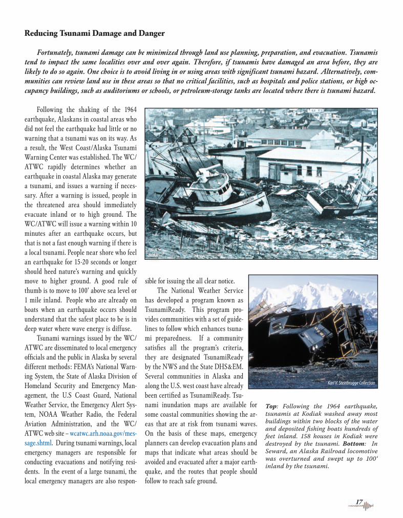
A sandblow that occurred in the central Alaska Range as a result of soil liquefaction from ground shaking during the November 3rd, 2002 Denali Fault Earthquake.
15
Soil Liquefaction
When loosely packed and wet sand is shaken during an earthquake, it may fl ow like liquid. This is called liquefaction. Anyone who has walked on a beach may have seen a small-scale version of this process. Stamp your foot in the sand near the water’s edge and suddenly the area of your footprint vibrates like gelatin.
Earthquake-induced liquefaction is often accompanied by cracks in the ground surface and small eruptions of sand and water called sandblows. During the 2002 Denali Fault earthquake, people in Northway watched sand erupting 4 feet out of the ground. When a soil liquefi es, it is unable to support the weight of the ground or any structures above it. Bridges and buildings may settle and tilt even though they with-stood strong ground shaking. If the liquefi ed area is on a slope, massive landslides may result.
The Bootlegger Cove Formation is the name of a soil that underlies much of Anchorage. Liquefaction of a part of the Bootlegger Cove Formation caused much of the destruction in the Anchorage area during the 1964 earthquake, and it causes people to feel earthquakes more strongly in western Anchorage. Soils that liquefy are not limited to the Anchorage area, but are present in many low-lying parts of Alaska where soil near the surface is saturated with water.
Update2_3_10_18.indd 15 3/10/04 3:28:51 PM

Tsunamis are ocean waves produced by earthquakes. The word comes from the Japanese language and means “harbor wave,” because of the devastating effects these waves have had on low-lying Japanese coastal communities. Tsu-namis are often incorrectly referred to as “tidal waves.” Not all earthquakes produce tsunamis, but when they do, the waves may sweep ashore causing damage both locally and at places thousands of miles from the earthquake epicenter. More than 90 percent of the deaths from the 1964 earthquake were the result of tsunamis. One hundred and six Alaskans died from these waves and an additional 16 people died from tsunamis that reached California and Oregon after the event.
Tsunamis consist of a series of waves with periods (the time between wave crests) from several minutes to an hour. These long periods cause the waves to behave dif-ferently than shorter period, wind-generat-ed waves. Whereas wind-generated waves will break and diffuse energy offshore, tsunamis normally do not break, and ar-rive as a fl ooding wave with strong cur-rents. For this reason, even tsunamis in the range of 3 to 6 feet in height can produce damage along shorelines. Tsunamis are not dangerous in deep water and they are rarely noticed by ships at sea. In the deep ocean, tsunamis travel at approximately 500 mph and may be only inches high. However, the same wave will slow down
and gain height dramatically as it enters shallow coastal water.
Tsunamis are produced in several ways. One way is by sudden regional uplift or subsidence of the seafl oor during an earthquake. Tsunamis begun in this way can travel long distances and cause destruc-tion thousands of miles from where the wave was generated. Underwater land-slides, called slumps, are another cause of tsunamis. Destruction in Seward, Whittier, Valdez and other places in 1964 was caused by waves triggered by underwater land-slides. These tsunamis are normally local-ized, but they are deadly because they reach the shoreline very quickly. Above-water landslides can also cause local tsunamis if
they enter a body of water. On July 9, 1958, in Lituya Bay, Alaska, a large earthquake started a giant landslide that ran into the head of the bay and generated a tsunami. The wave ran up a mountainside on the opposite side of the bay to a height of more than 1,720 feet. Two fi shing vessels an-chored in the bay sank and two people died.Volcanic eruptions are also capable of initi-ating tsunamis, especially in parts of Alaska where active volcanoes are located close to the sea. If volcanic mass fl ows, such as debris avalanches, lahars, or pyroclastic fl ows are large enough, they may initiate waves as they pass into the ocean. Although tsunami generation by these processes is relatively uncommon, under certain condi-tions large and damaging tsunamis can re-sult and they do pose a threat to coastal communities in some areas of the Alaska Peninsula, the Aleutian Islands and south-ern Cook Inlet.
16
Tsunami basics
Tsunami Inundation Mapping for Alaskan Communities
The Alaska Earthquake Information Center helps Alaskan coastal communities to mitigate the risk from tsunamis by mapping the potential inundation zones for each communi-ty. This project is a part of the National Tsunami Hazard Mitigation Program, a cooperative effort of NOAA, the USGS, and the western coastal states of Alaska (AEIC, DHS&EM, ADGGS), Washington, Oregon, California, and Hawaii. This process involves iden-tifying likely tsunami sources for each coastal community, calculating potential areas of inundation using a detailed computer model, and creating a hazard map and report. These products are used by local emergency managers to create evacuation plans, and for public education about tsunami risk and other hazard mitigation efforts.
Many of Alaska’s coastal communities have the highest tsunami hazard found anywhere in the United States. Mapping is planned for all coastal communities with signifi cant risk. The DHS&EM prioritizes communities for inundation mapping based on historical tsunami hazard, population and in-frastructure at risk, availability of bathymetric and topographic data, and the level of community commit-ment to hazard mitigation. High-risk communities such as Kodiak, Homer, Seward, and Sitka have taken top priority. Work will continue until all communities meeting DHS&EM criteria are accurately mapped.
White areas indicate tsusami crests and dark blue areas indicate depres sion of sea level. Tsuami simulations like this one are used to create inun dation maps for Alaska’s coastal com munities. Seismic events that occur within the Alaska-Aleutian subduction zone have a high poten tial for gener ating both local and Pacifi c-wide tsunamis. Th ese three snapshots show a computer sim-
ulation of the tsunami generated bythe 1964 earthquake at diff er ent
time intervals. Kodiak Island is in the center of the frame.
30 min.
+30 min.
+1 hr.
+2 hr.
Update2_3_10_18.indd 16 3/10/04 3:28:53 PM
Reducing Tsunami Damage and Danger
Fortunately, tsunami damage can be minimized through land use planning, preparation, and evacuation. Tsunamis tend to impact the same localities over and over again. Therefore, if tsunamis have damaged an area before, they are likely to do so again. One choice is to avoid living in or using areas with signifi cant tsunami hazard. Alternatively, com-munities can review land use in these areas so that no critical facilities, such as hospitals and police stations, or high oc-cupancy buildings, such as auditoriums or schools, or petroleum-storage tanks are located where there is tsunami hazard.
Following the shaking of the 1964 earthquake, Alaskans in coastal areas who did not feel the earthquake had little or no warning that a tsunami was on its way. As a result, the West Coast/Alaska Tsunami Warning Center was established. The WC/ATWC rapidly determines whether an earthquake in coastal Alaska may generate a tsunami, and issues a warning if neces-sary. After a warning is issued, people in the threatened area should immediately evacuate inland or to high ground. The WC/ATWC will issue a warning within 10 minutes after an earthquake occurs, but that is not a fast enough warning if there is a local tsunami. People near shore who feel an earthquake for 15-20 seconds or longer should heed nature’s warning and quickly move to higher ground. A good rule of thumb is to move to 100’ above sea level or 1 mile inland. People who are already on boats when an earthquake occurs should understand that the safest place to be is in deep water where wave energy is diffuse.
Tsunami warnings issued by the WC/ATWC are disseminated to local emergency offi cials and the public in Alaska by several different methods: FEMA’s National Warn-ing System, the State of Alaska Division of Homeland Security and Emergency Man-agement, the U.S Coast Guard, National Weather Service, the Emergency Alert Sys-tem, NOAA Weather Radio, the Federal Aviation Administration, and the WC/ATWC web site – wcatwc.arh.noaa.gov/mes-sage.shtml. During tsunami warnings, local emergency managers are responsible for conducting evacuations and notifying resi-dents. In the event of a large tsunami, the local emergency managers are also respon-
sible for issuing the all clear notice.The National Weather Service
has developed a program known as TsunamiReady. This program pro-vides communities with a set of guide-lines to follow which enhances tsuna-mi preparedness. If a community satisfi es all the program’s criteria, they are designated TsunamiReady by the NWS and the State DHS&EM. Several communities in Alaska and along the U.S. west coast have already been certifi ed as TsunamiReady. Tsu-nami inundation maps are available for some coastal communities showing the ar-eas that are at risk from tsunami waves. On the basis of these maps, emergency planners can develop evacuation plans and maps that indicate what areas should be avoided and evacuated after a major earth-quake, and the routes that people should follow to reach safe ground.
Top: Following the 1964 earthquake, tsunamis at Kodiak washed away most buildings within two blocks of the water and deposited fi shing boats hundreds of feet inland. 158 houses in Kodiak were destroyed by the tsunami. Bottom: In Seward, an Alaska Railroad locomotive was overturned and swept up to 100‘ inland by the tsunami.
17
30 min.
Update2_3_10_18.indd 17 3/10/04 3:28:59 PM

18
Tsunami safety rules
q A strong earthquake felt in a low-lying coastal area is a natural warning of possible immediate danger. Keep calm and quickly move to higher ground, away from the coast.
q Not all large earthquakes cause tsuna-mis, but many do. If the quake is located near or directly under the ocean, the prob-ability of a tsunami increases. When you hear that an earthquake has occurred in the ocean or coastal region, prepare for a tsunami emergency.
q A tsunami is not a single wave, but a se-ries of waves. The fi rst wave is not necessar-ily the largest. Stay out of danger until an “all clear” is issued by a competent authority.
q Approaching tsunamis are sometimes heralded by a noticeable rise or fall of coastal water. This is nature’s tsunami warning and should be heeded.
q A small tsunami at one beach can be a giant a few miles away. Don’t let the modest size of one make you lose respect for all.
q Sooner or later, tsunamis visit every coastline in the Pacifi c. All tsunamis, like hurricanes, are potentially dangerous even though they may not damage every coast-line they strike.
q Never go down to the shore to watch for a tsunami. When you can see the wave you are too close to escape.
q During a tsunami emergency, your lo-cal emergency management offi ce, police force, and other emergency organizations will work to protect your life and property. Give them your fullest cooperation.
q Stay tuned to your radio, marine radio, NOAA Weather Radio, or television sta-tions during a tsunami emergency. Bulle-tins issued through your local emergency management offi ce and the National Weather Service offi ces can save your life.
Tsunami Warnings
When a large earthquake occurs near the coastline of the northern Pacifi c Ocean, an automated system at the West Coast/Alaska Tsunami Warning Center rapidly determines its location (epicenter) and magnitude. If the earthquake is located offshore and has a magnitude of 7 or larger it is considered large enough to generate a tsunami. A tsunami warning is then issued for a limited area near the epicenter of the earthquake. This warning is issued in Alaska through the military, Coast Guard, National Weather Service, Alaska Division of Homeland Security and Emergency Management, Federal Aviation Administration and other federal agencies. A tsunami watch is issued to adjacent areas of Alaska, Canada, and West Coast states as appropriate, alerting them to a possible tsunami threat.
If a signifi cant tsunami is detected by instruments that measure tides near the epicenter of the earthquake, the warning will be expanded to the entire coastline of the region. If no wave was generated, the warning will be canceled. Although this will occasionally cause a warning to be issued when no wave is present, the alternative of leaving communities unaware of a potential disaster is undesir-able. The West Coast/Alaska Tsunami Warning Center works closely with the other tsunami warning centers because tsunamis gener-ated in distant parts of the Pacifi c Ocean, such as Japan or Chile, have also reached Alaska. A tsunami from northern Japan would take 4 hours to reach Adak Island and 8 hours to reach Kodiak, which allows Alaskans time to prepare if a watch has been issued. A tsunami travels from Peru or Chile to Kodiak in 16 to 18 hours.
Damage in Seward following the 1964 earthquake. Th e waterfront area, railroad yard, and petroleum storage tank facilities were devastated by the tsunami.
Update2_3_10_18.indd 18 3/10/04 3:29:04 PM

Earthquake Magnitude and Intensity Scales Compared
�������������������
���������������������������������
������������������������������������������������
������������������������������������
������������������
� ������� ������ ������ ����������������������������������������
� �������������� ������ ���� ����������������������������������������
� ��������������� �� ������ ��������������������������������������� ��������
� ��������������� ���� �������� �������������������������������������������������������
� ���������������� ����� ����� ���������������������������������������
� ���������������� �������� ������ ������������������������������������������
19
Measuring an earthquake
The energy suddenly released during an earthquake can produce a terrifying ex-perience. The energy of the 1964 Alaska earthquake was equal to that of 63,000 Hi-roshima-size atomic bombs. The size of an earthquake is commonly stated in terms of its magnitude, and the effects of an earth-quake are measured by its intensity.
There are several ways that earthquake magnitude is expressed. The most famous was devised in 1934 by the late Dr. Charles F. Richter. On the Richter scale, and other magnitude scales, each whole number step represents a tenfold increase in the size of seismic waves measured on a seismograph--a machine that measures how much the ground moves in an earthquake. However, a single step on the Richter scale corresponds to a thirty fold increase in the amount of energy released in an earthquake. The news media usually refer to the size of an earth-
quake as having been measured on the Richter scale. However, a number of differ-ent scales are in common use. For example, the “moment” magnitude is now the stan-dard for measuring large quakes. Since the late 1970s, scientists have determined that Richter magnitudes can underestimate the energy released by the largest earthquakes. As a result, the magnitude of the 1964 earthquake in Alaska, which was initially assigned a Richter magnitude of 8.4, is now considered to have had a magnitude of 9.2.The intensity of an earthquake is not mea-sured using seismographs like Richter-scale magnitudes are, but is based upon earth-quakes’ effects on man-made structures. The intensity of an earthquake can be very different in places only a hundred feet apart because the amount of sha k ing, and there-fore the damage, depends upon the kind of soil or rock beneath a particular location.
A modifi ed version of the Mercalli in-tensity scale, developed in 1902 by an Ital-ian geologist, is often used to measure earthquake intensity. This scale ranges be-tween Roman numerals “I,” which is rarely felt, to “XII,” which results in damage to nearly all structures. The scale is outlined in the table below.
Most residents in earthquake-prone parts of Alaska have experienced intensities up to IV. In the 1964 Alaska earthquake, there were Mercalli intensities of X near the epicenter of the quake in Prince William Sound; there were intensity VII effects in Kodiak, Homer, Seward, Valdez, Cordova, and Anchorage; there were intensity V to VI effects in Fairbanks, Fort Yukon, Yakutat, and Sitka. Regardless of how the magnitude or intensity of an earthquake is measured, any earthquake is signifi cant if it impacts you, your family, or your community.
Update2_3_10_18.indd 19 3/10/04 3:29:05 PM

forward with a jerk, and then stops. If you keep pulling, the cycle repeats itself, just like the earthquake cycle. There are a number of different regions that produce earthquakes in Alaska, and all are the result of the sliding of the Pacifi c plate toward the northwest, past southeastern Alaska and beneath southern Alaska.
The next two fi gures shows where earthquakes occur in southern Alaska. The Pacifi c plate is located beneath the Pacifi c Ocean and slides past southeastern Alaska at a rate of about 2 inches per year. The main fault near southeastern Alaska, along which the plates slide past each other, is called the Queen Charlotte-Fairweather fault. It is essentially a northern continua-tion of the more famous San Andreas fault in California. The Queen Charlotte-Fair-weather fault is a right-lateral strike-slip
20
History of earthquakes in Alaska
Written records of earthquakes in Alaska extend back only to 1788, however, studies of more ancient earthquakes can give a better understand-ing of where they occur, how often they occur, and how large they are. Stud-ies of recent marine and river sediment layers, buried forests and soils can reveal a record of subsidence or uplift related to major earthquakes. Past tsunamis sometimes leave recognizable sand deposits. In certain cases, tree rings can be used to estimate when an ancient earthquake occurred. Carbon 14 dating of sedimentary layers that have been offset by faults, or submerged in coastal areas during large earthquakes, can help to determine when an-cient earthquakes occurred. The oral history of Alaska Natives includes legends and stories that may relate to prehistoric earthquakes.
In Alaska, the study of ancient earth-quakes, or paleoseismology, indicates that the last earthquake of comparable size to the 1964 Good Friday earthquake oc-curred 600 to 800 years ago. Some may conclude that because there was a major earthquake just 40 years ago that there is no longer much earthquake hazard in parts of southern Alaska. However, large earthquakes, on the order of magnitude 7 to 8, occur much more often and can be extremely devastating if they are close to population centers.
Looking at the geology of Alaska can help us to understand why there are earth-quakes and where they occur.
Why there are Earthquakes in Alaska
The surface of the Earth, also known as the crust, is made up of a dozen or so large fragments called “plates.” Most of these plates are more than a thousand miles across and more than 40 miles thick. The Earth’s crust has been composed of moving plates for at least four billion years, and these plates will continue to shift in the future. The movement of the plates oc-curs because it is hot in the middle of the Earth, and relatively cold at the surface. The Earth cools off by convecting hot mantle to the surface and releasing heat at the mid-ocean ridges where the crust is
thinnest. Hot mantle spreads away from the mid-ocean ridges and eventually cools and sinks back toward the middle of the Earth, where it is reheated before rising to the surface again. This convection cycle causes the plates to move steadily, but slowly, away from the mid-ocean ridges and past each other at rates up to 4 inches per year. Most earthquakes occur at the plate boundaries where pieces of the crust are sliding past each other, and some earthquakes are internal to plates.
These immense plates move at a steady rate, but at their edges the sliding motion is neither smooth nor constant. The motion of the plates strains or deforms the rocks at their boundaries because of friction with the neighboring plate until the rocks can no longer withstand the stress. Then, a sud-den slip along a fault releases energy that causes earthquake shaking. When the plates are not slipping by each other, but are “locked” together, no earthquakes oc-cur. Eventually enough strain will build up to cause the locked section to break and the two plates will slide past each other, caus-ing an earthquake. The making of earth-quakes is a bit like pulling a concrete block across a rough surface with a bungee cord. At fi rst you pull on the bungee cord, it stretches out, and the block does not move. Eventually, the pull on the cord is strong enough to get the block moving, it slides
Alaska Earthquake Statistics
Each year about 12,000 earthquakes shake the state of Alaska. That’s an average of more than 30 each day!
q Alaska has 11 percent of the world’s recorded earthquakes.
q Alaska has more earthquakes than the rest of the United States combined.
q Three of the six largest earthquakes in the world were in Alaska.
q Seven of the ten largest earthquakes in the United States were in Alaska.
Since 1900, Alaska has had an average of:
q One magnitude 8 or larger earthquake every 13 years.
q One magnitude 7 to 8 earthquake every year.
q Six magnitude 6 to 7 earthquakes per year.
q Fortyfi ve magnitude 5 to 6 earthquakes per year.
q Threehundred and twenty magnitude 4 to 5 earthquakes per year.
q An average of a 1,000 earthquakes are located in Alaska each month.
Update2_3_10_18.indd 20 3/10/04 3:29:06 PM
65º
60º
55º 155º
135º 150º 140º 145º
NORTHAMERICAN
PLATE
PACIFIC PLATE
Fa i rweather
Queen C
har lo t te Fau l t
������������
A l e u t i a n M e g a t h
r us t
5.4 cm/yr
4.9 cm/yr
Anchorage
Seis Hazard
%g
0 - 2
2 - 4
4 - 8
8 - 16
16 - 24
24 - 32
> 32
0 100 200 300 400 500 km
Fairbanks
November 3, 2002 RuptureNovember 3, 2002 RuptureNovember 3, 2002 RuptureNovember 3, 2002 Rupture
������
����
TotschundaFau l t
Dena l i Fau l t
Yakutat Terrane
���
����
�
4.6 cm/yr
C
astle Mtn. Fault
21
fault, which means that if you were looking across the fault at another person, they would move to your right during an earthquake. There was a magnitude 7.8 earthquake on this fault in 1958. The entire southern Alaska-Aleutian mar-gin is a subduction zone where the Pacifi c plate is sliding to the northwest beneath the crust of southern Alaska, down into the Earth’s mantle. Subduction zones produce the world’s largest earthquakes, and most earthquakes felt in the Anchor-age area are subduction zone earthquakes. There are several kinds of subduction zone earthquakes. The 1964 earthquake was a ‘mega-thrust’ earthquake related to sliding along the shallow-est part of the subduction zone. Farther down the subduc-tion zone, the Pacifi c plate bends downward into the mantle. The bending process cracks the Pacifi c plate in the same way as if you were bending a candy bar, and this causes earthquakes. By far the most commonly felt earthquakes in southcentral Alaska are related
to the sliding and bending of the Pacifi c plate between 18 and 60 miles beneath the earth’s surface. These are called ‘intraplate’ earthquakes, and they can approach mag-nitude 7.5. The magnitude 6.8 Nisqually earthquake in Washington State in 2001 was an intraplate earthquake that caused an estimated 2 billion dollars in damage. Earthquakes in interior Alaska are caused by the collision of a piece of crust into the edge of southern Alaska. The collision is occurring near Yakutat, and thus the piece of crust is called the Yakutat terrane. The Yakutat terrane is moving quickly, at al-most 2 inches per year. Earthquakes are generated at the margins of the Yakutat ter-rane, and further inland where the crust of Alaska is breaking in response to being shoved northward. The Denali fault is the largest of the faults in interior Alaska and it moves in response to the Yakutat terrane collision. On November 3rd, 2002, a mag-nitude 7.9 earthquake on the Denali fault caused more than 40 million dollars in damage. There are other faults on both sides of the Alaska Range, and in the Cook
Inlet region, that may have infre-quent shallow, and damaging
earthquakes.
Above: Th is map shows the combined seismic hazard in much of Alaska. Th e highest seismic hazard is shown in red, the lowest in green. Th e highest hazard lies along the plate margins, along the margins of the Yakutat terrane, and in zones where the Yakutat terrane collision is aff ecting interior Alaska. Th e Yakutat terrane collision is ultimately pushing up Mt. McKinley (Denali). Note: this hazard map does not portray local variations in earthquake hazard due to soil conditions. Below: Th is map shows that the plate tectonic setting of southern Alaska consists of the Pacifi c plate sliding past southeastern Alaska and beneath southern Alaska. Th e Pacifi c plate can be thought of as a conveyor belt. Riding on the Pacifi c plate is the Yakutat terrane (YAK), which is a buoyant piece of crust that is colliding with the southern Alaska margin. Interior Alaska is also being squeezed because of the collision of the Yakutat Terrane. Earthquakes occur along plate boundaries and in interior Alaska where it is being squeezed.
Update2_3_10_18.indd 21 3/10/04 3:29:12 PM
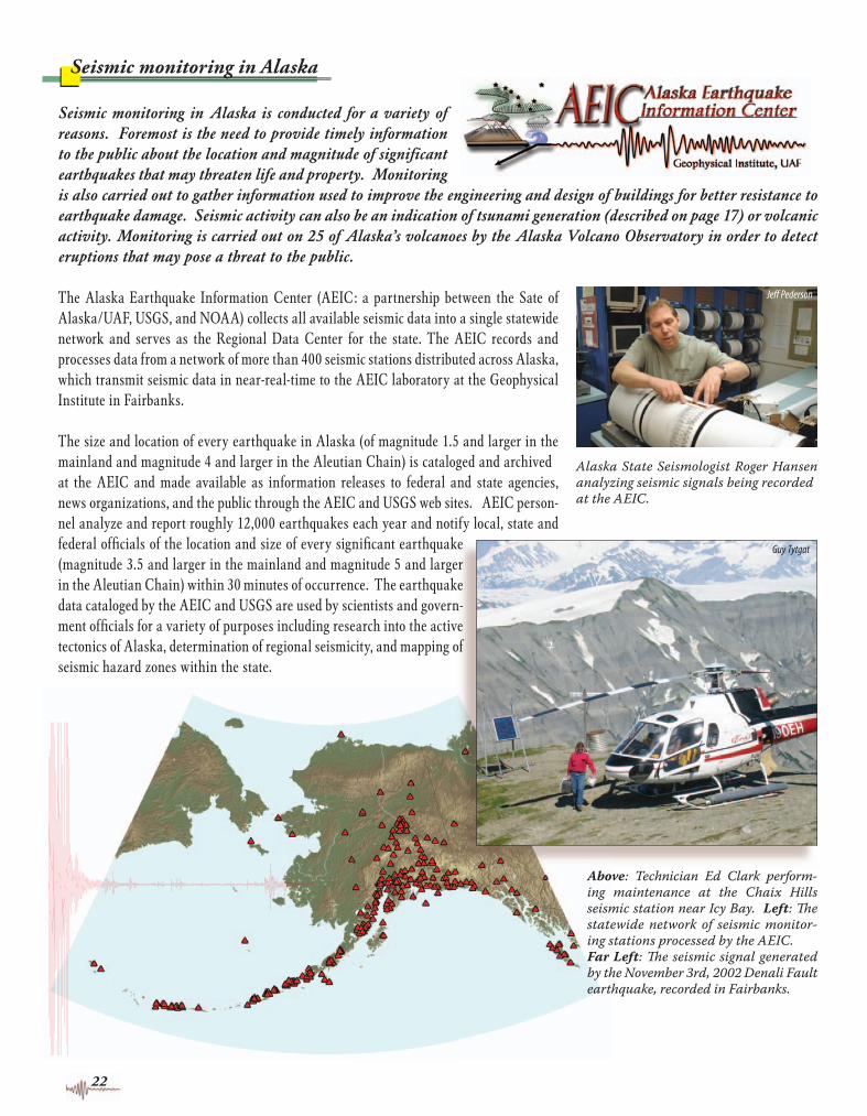
Alaska State Seismologist Roger Hansen analyzing seismic signals being recorded at the AEIC.
Above: Technician Ed Clark perform-ing maintenance at the Chaix Hills seismic station near Icy Bay. Left: Th e statewide network of seismic monitor-ing stations processed by the AEIC. Far Left: Th e seismic signal generated by the November 3rd, 2002 Denali Fault earthquake, recorded in Fairbanks.
Seismic monitoring in Alaska is conducted for a variety of reasons. Foremost is the need to provide timely information to the public about the location and magnitude of signifi cant earthquakes that may threaten life and property. Monitoring is also carried out to gather information used to improve the engineering and design of buildings for better resistance to earthquake damage. Seismic activity can also be an indication of tsunami generation (described on page 17) or volcanic activity. Monitoring is carried out on 25 of Alaska’s volcanoes by the Alaska Volcano Observatory in order to detect eruptions that may pose a threat to the public.
The Alaska Earthquake Information Center (AEIC: a partnership between the Sate of Alaska/UAF, USGS, and NOAA) collects all available seismic data into a single statewide network and serves as the Regional Data Center for the state. The AEIC records and processes data from a network of more than 400 seismic stations distributed across Alaska, which transmit seismic data in near-real-time to the AEIC laboratory at the Geophysical Institute in Fairbanks.
The size and location of every earthquake in Alaska (of magnitude 1.5 and larger in the mainland and magnitude 4 and larger in the Aleutian Chain) is cataloged and archived at the AEIC and made available as information releases to federal and state agencies, news organizations, and the public through the AEIC and USGS web sites. AEIC person-nel analyze and report roughly 12,000 earthquakes each year and notify local, state and federal offi cials of the location and size of every signifi cant earthquake (magnitude 3.5 and larger in the mainland and magnitude 5 and larger in the Aleutian Chain) within 30 minutes of occurrence. The earthquake data cataloged by the AEIC and USGS are used by scientists and govern-ment offi cials for a variety of purposes including research into the active tectonics of Alaska, determination of regional seismicity, and mapping of seismic hazard zones within the state.
22
Seismic monitoring in Alaska
Update2_3_10_18.indd 22 3/10/04 3:29:26 PM

23
Other Sources of Information
Your local library is a good place to start. Ask for the material referenced below. Many valuable information resources are available on the World Wide Web. Internet addresses are provided in the sections below.Look at the “Earthquake Safety Information” in the introductory pages of most telephone directories.Ask your local chapter of the American Red Cross for pamphlets on preparedness and survival.
Agencies & Organizations:
Alaska Earthquake Information Center, www.aeic.alaska.edu,Geophysical Institute, University of Alaska Fairbanks, 903 Koyukuk Dr., P.O. Box 757320, Fairbanks, AK 99775-7320, (907) 474-7320. Provides seismic monitoring for the State of Alaska and has compilations of location, magnitude, and depth of Alaskan earthquakes.
Alaska Division of Geological & Geophysical Surveys, www.dggs.dnr.state.ak.us, 3354 College Road, Fairbanks, AK 99709, (907) 451-5010. Technical publications and maps about energy and mineral resources, geologic hazards, and water resources.
West Coast/Alaska Tsunami Warning Center, wcatwc.arh.noaa.gov, Palmer, AK, (907) 745-4212. Provides tsunami bulletins to coastal residents of Alaska, B.C., and the U.S. west coast for potentially tsunami-generating earthquakes in the Pacifi c basin.
Applied Technology Council, www.atcouncil.org, 555 Twin Dolphin Dr., #550, Redwood City, CA 94065, (650) 595-1542. Provides technical publications for engineers, architects, and other people interested in the details of design for reducing earthquake damage to buildings and their contents.
Alaska Division of Homeland Security and Emergency Management, www.ak-prepared.com, P.O. Box 5750, Fort Richardson, AK 99505-5750, (907) 428-7000 or (800) 478-2337. Conducts preparedness and mitigation programs and workshops. Materials available upon request.
Earthquake Engineering Research Institute, www.eeri.org, 499 14th St. #320, Oakland, CA 94612-1934, (510) 451-0905, [email protected]. Technical information of most interest to engineers, re-searchers, and practicing professionals. Videotapes, annotated slide sets, and reconnaissance reports about earthquake hazard mitigation and the response of buildings, lifelines, and bridges during major earth-quakes around the world. Free catalog.
Federal Emergency Management Agency,www.fema.gov, Region 10 (includes Alaska), 130 228th Street, SW, Bothell, WA 98021-9796, (425) 487-4604.
Municipality of Anchorage, Building Safety Division, www.muni.org/bsd/mainpage.cfm, P.O. Box 196650, Anchorage, AK 99519-6650, (907) 343-8211. Conducts and provides training for post-earth-quake building safety evaluations.
U.S. Geological Survey, www.usgs.gov, 4200 Uni-versity Dr., Anchorage, AK 99567-4667, (907) 786 7011. Publications and maps concerning earthquake haz-ards, faults, volcanoes, and permafrost.
-
Additional Web Links
www.aeic.alaska.edu/cgi-bin/release_info.pl Alaska Earthquake Information Center web-site with list of most recent earthquakes in Alaska.
earthquake.usgs.gov - Main web page of USGS earthquake hazards program, with in-formation about recent large earthquakes around the world.
geopubs.wr.usgs.gov/open-fi le/of95-624/ “Earthquakes in Alaska” poster of centerfold of this pamphlet.
pasadena.wr.usgs.gov/shake/ak - “Did You Feel It?” Web site to report felt earthquakes.
earthquake.usgs.gov/shakemap - ShakeMap website, which will have a link to Alaska when it becomes available.
www.fema.gov/kids - “FEMA for Kids” web-site, current disaster information, prepared-ness, facts and fi gures, disaster experiences related by children, games & quizzes.
www.fema.gov/hazards/earthquakes - Earth-quake safety and preparedness information.
www.prh.noaa.gov/pr/ptwc/ - Main web page of the Pacifi c Tsunami Warning Center
wcatwc.arh.noaa.gov/tsunamiready/tready.htm - The “TsunamiReady” program of the National Weather Service
Update2_3_10_18.indd 23 3/10/04 3:29:31 PM

24
American Red Cross
Anchorage Fairbanks(907) 646-5400 (907) 456-5937
Juneau Soldotna(907) 463-5713 (907) 262-4541
Wasilla (907) 357-6060
Local Emergency Management Offi ces
Anchorage (907)343-1400
Current Emergency Information:(907) 343-4701
24 hour number through Anchorage Fire Dispatch:
(907) 267-4950
Fairbanks (907) 459-1481
24 hour number: (907) 474-7721
Kenai(907) 262-4910
Mat-Su Valley(907) 373-8800
Books on Geological Hazards
Earthquakes. By Bruce Bolt, W.H. Freeman, New York, 2003, 320 pages, ISBN: 0716719096, $45.05
The Citizens’ Guide to Geologic Hazards. Edward B. Nuhfer, Richard J. Proctor, and Paul H. Moser, A.I.P.G., 1993, 134 pages, ISBN: 0933637101. $24.00, A.I.P.G., 8730 Yates Dr. #200, Westminster, CO 80031-3681, (303) 412-6205.
Earth in Turmoil: Earthquakes, Volcanoes, and Their Impact on Humankind, by Kerry E. Sieh and Simon LeVay, W.H. Freeman, New York, 1998, 275 pages, ISBN: 0716736519
Engineering and Architecture Pro fes sional Societies
Society of Professional Engineers, ASPE Alaska Chapter, www.myeterra.com/aspe/
American Institute of Architects, AIA Alaska Chapter, P.O. Box 10-3563, Anchorage, AK 99510-3563 (907) 276-2834. www.aiaak.org
ASFE, The Association of Engineering Firms Practicing in the Geosciences, 8811 Colesville Road, Suite G106, Silver Spring, MD 20910 (301) 565-2733. www.asfe.org
Technical Reports on Regional Plan ning to Reduce Earthquake Risk
The following documents are all technical in nature and are of most interest to regional plan-ners and residents interested in regional planning.
Earthquake Alaska; Are we prepared? Edited by R. Combellick, R. Head, and R. Updike, 1994, 192 pages, U.S.G.S. Open File Report 94-218. pubs.er.usgs.gov/pubs/ofr/ofr94218
Probabilistic seismic hazard maps for Alaska. By R. Wesson, A. Frankel, C. Mueller, and S. Harmsen, 1999, Probabilistic Seismic Hazard Maps of Alaska: U.S.G.S. Open-File Report 99-36. pubs.er.usgs.gov/pubs/ofr/ofr9936 Updates available at: eqhazmaps.usgs.gov
Geologic-hazards mitigation in Alaska: A review of federal, state, and local policies. By R.A. Combellick, 1985, Alaska Division of Geological and Geophysical Surveys Special Report 35, 70 pages, $3.00. www.dggs.dnr.state.ak.us/pubseries.html
A workshop on “Evaluation of regional and urban earthquake hazards and risk in Alaska.” Edit-ed by W. Hayes and P. Gori, 1986, 386 pages, U.S.G.S. Open-File Report 86-79. pubs.er.usgs.gov/pubs/ofr/ofr8679
Anchorage Coastal Resources Atlas. Atlas has maps of geologic haz-ards in the Municipality of Anchorage, including the frequently used Gound-Failure Susceptibility Map. Municipality of Anchorage, 1981-1982, v. 1-4. Available at libraries and online at:www.dggs.dnr.state.ak.us(Publication MP32)
Books and Materials for Children, Parents and Teachers
Age 3- 8: We Shake in a Quake. By Hannah Gelman Givon, Illustrations by David Uttal, Ten Speed Press, Berkeley, 2000, 32 pages, ISBN: 1582460221
Age 9 - 12:Earthquake Games: Earthquakes and Vol-canoes Explained by Games and Experiments. By Matthys Levy and Christina Blatt, Illustra-tions by Mario George Salvadori, Marget K. McElderry (publisher), 1997, ISBN: 0689813678.
All Ages:Movers & Shakers (Earthquake prepared-ness kit w/ video for K-12 classrooms, lesson plans for all grade levels). Free to schools, send to: Movers & Shakers, State Farm Insurance Co., Public Relations Dept. (E-8), One State Farm Plaza, Bloomington, IL 61710-0001. www.statefarm.com/educate/moveshk.htm
Update2_3_10_18.indd 24 3/10/04 3:29:33 PM

This pamphlet is based on a pamphlet that originally appeared in the Anchorage Daily News in
1994 on the 30th anniversary of the Good Friday earthquake. The concept for that booklet and
much of the text came from a similar publication about the earthquake threat in San Francisco,
entitled The Next Big Earthquake in the Bay Area May Come Sooner Than You Think, by Peter
Ward, USGS. Additional material came from On Shaky Ground: Living with Earthquakes on
the North Coast, by Lori Dengler and Kathy Moley, Humboldt State University.
This pamphlet was prepared by the Alaska Earthquake Information Center (AEIC), the University of Alaska Fairbanks Geophysical Institute (GI-UAF), and the U.S. Geological Survey (USGS), Department of the Interior, in cooperation with the Alaska Department of Homeland Security and Emergency Management (DHS&EM), Alaska Division of Geological & Geophysical Surveys (ADGGS), NOAA West Coast/Alaska Tsunami Warning Center (WC/ATWC), and the Federal Emer-gency Management Agency (FEMA), Department of Homeland Security. Additional funding provided by the Conoco Philips Company.
The pamphlet was written and compiled by Peter Haeussler (USGS), Roger Hansen (AEIC), Rod Combellick (ADGGS), Paul Whitmore (WC/ATWC), and Tom Smayda (DHS&EM).
Layout and design by Deborah Coccia Manning, Digital Design Center, GI-UAF.
Editing by James Roush, AEIC.
Photographs from the Karl V. Steinbrugge Collection of the Earthquake Engineering Research
Center are provided courtesy of the National Information Service for Earthquake Engineer-
ing, University of California Berkeley.
Credits:
This pamphlet is meant to be instruc-tional and to provide information that will help you understand and reduce your risk from earthquakes. The information in this publication is believed to be accurate at the time of publication. The agencies and indi-viduals involved in the preparation and distribution of this information assume no responsibility for any damage that arises from any action that is based on informa-tion found here. Any use of trade, product, or firm names is for descriptive purposes only and does not imply endorsement by the U.S. Government, the State of Alaska, or any cooperating institution.
This publication was released by the Alaska Earthquake Information Center, the United States Geological Survey, the Federal Emergency Management Agency, the Alaska Division of Homeland Security and Emergency Management, the Alaska Division of Geological & Geophysi-cal Surveys, and the West Coast/Alaska Tsunami Warning Center at a cost of $ 0.17 per copy to provide the public with information regarding earthquake preparedness. This publication was printed in Anchorage, Alaska by AT Publishing & Printing Inc.
AD G G S
Additional copies can be obtained from the Alaska Division of Homeland Security and Emergency Management, the Alaska Earthquake Information Center, the U.S. Geological Survey, and the Alaska Division of Geological & Geophysical Surveys. This publication is also available online at www.aeic.alaska.edu.
UAF is an affirmative action/equal opportunity employer and educational institution.
Back Cover: Road damage from the Nov. 3rd, 2002 Denali Fault earthquake (top and middle). GI-UAF graduate student Kelly Kore installing a temporary seismic station to monitor aftershocks from the Denali Fault earthquake (bottom). Front Cover: Map of earthquakes in Alaska from 1898 to November 2003 (upper right). Earthquake depths: blue 0-33 km, green 33-75 km, orange 75-125 km and red 125+ km.Photograph (lower left) of damage to the Anchorage J.C. Penny building after the 1964Good Friday earthquake.
D H S&E M
WC/ATWCNAT
IONAL
OCEA
NICAND
ATMOSPHERIC ADMINISTRATIO
N
U.S. DEPARTMENT OF COMME
RCE