Embed Size (px)
Citation preview

ARCHAEOLOGY IN TUCSON Vol. 8, No. 4 Newsletter of the Center for Desert Archaeology January 1994
The Gibbon Springs Site: A Hohokam Village in the Foothills By Mark C. Slaughter, SWCA, Inc., Environmental Consultants
The Gibbon Springs site, located in the northeastern portion of the Tucson Basin, is a Tanque Verde phase hamlet settled in the mid-1200s. As part of a federal permit application, recent excavation of this site was undertaken by archaeologists from SWCA, Inc., Environmental Consultants, and by efforts of many volunteers. The principal funding for the project was provided by Perini Land and Development Company.
Perennial springs are believed to have drawn prehistoric ag- riculturalists to Gibbon Springs. They provided water, wild plant resources, and quality soils for raising crops. Once established, the inhabitants prospered but then suddenly left. They abandoned their homes and unwanted materials that were later claimed by twentieth-century pothunters for their aesthetic and monetaryvalues. Although the site was vandalized, we were still able to recover data from more than 200 features. All of these remains were associated with the Tanque Verde phase of the Classic Period. A HOHOKAM SITE WITH TREERING DATES
Because sites in southern Arizona sel- dom contain construc- tion materials that can be tree-ring-dated, most Hohokam sites are dated from carbon samples, the archae- omagnetic sampling of hearths, or through ceramic design and vessel style. Unfortu- nately, none of these methods provide the tight chronological control that is possible
Excavated structures and their relationship to the compound.
with tree-ring Location of the Gibbon Springs site and other Classic Period sites.

Page 2 Archaeology in Tucson Newsletter Vol. 8, No. 4
Several house clusters outside the compound likely represent cooperating household groups. Unfortunately, we do not know what features may have been present to the south of the compound. Construction of modem homes has destroyed this portion of the site.
No differences in social status were found at the site, suggesting that no one person or group controlled access to goods or their distribution. Exotics such as shell, turquoise, decorated ceramics, and obsidian were found away from the compound as frequently as within it. The major distinction between the compound and noncompound areas is in the amount of stored materials. As indicated by the vessels and macrobotanical remains recovered, large quantities of maize and beans were kept in the compound. Therefore, the one storage structure
Well-plastered floors allow archaeologists to reconstruct the pattern of roof-support beams. This example is from inside the compound.
dates. At the Gibbon Springs site, we were fortunate to recover several datable species of pinyon and ponderosa pine. Although their research is ongoing, the Tree-Ring Lab of the University of Arizona has determined that one sample has a cutting date of A.D. 1249. ARRANGEMENT OF THE HAMLET
The Gibbon Springs site is arranged around a central compound and can be divided into five spatially distinct precincts ranging from habitation areas to agricultural fields. Four structures are within the compound, which appears to have been the focus of communal activities. Two of the structures were used for habitation and one for storage. The fourth structure was the largest at the site, contained two hearths, and may have had a bench around its interior. These, and other data, suggest that it was a meeting place or was associated with other unknown communal activities.
Artist's rendering of how the compound might have looked.
there was probably for communal use.
HOHOKAM MENU ITEMS Botanical materials recovered from the compound indicate
that many plant remains were stored in seed and processed form. Thousands of tansy mustard seeds clumped together in a ball, corn meal, and hundreds of charred beans were recovered.
Agricultural fields at the site contained numerous check- dams and rockpile features. A canal that originated near the springs and fed into a series of man-made checkdams and terraces was also found.
Faunal remains, including deer, pronghorn antelope, and bighorn sheep, were well preserved and common to the whole site. The faunal data, combined with the high projectile-point count, suggest that the residents of the Gibbon Springs site hunted more frequently than other Hohokam.
INTERACTIONS WITH PEOPLES OF THE SAN PEDRO VALLEY
Because few Tucson Basin Classic period sites have been adequately excavated or reported, interactions between Gibbon
October 1994 Archaeology in Tucson Newsletter Page 3 Springs inhabitants and other prehis- toric communities are difficult to understand. The Classic period is characterized by population move- ments, shifts in exchange and interac- tion networks, and changes in social sys- tems. The materials recovered from the Gibbon Springs site reflect these changes.
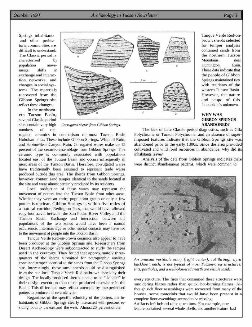
In the northeast- ern Tucson Basin, several Classic period sites contain very high Corrugated sherds from Gibbon Springs. numbers of cor- rugated ceramics in comparison to most Tucson Basin Hohokam sites. These include Gibbon Springs, Whiptail Ruin, and Sabino/Bear Canyon Ruin. Corrugated wares make up 15 percent of the ceramic assemblage from Gibbon Springs. This ceramic type is commonly associated with populations located east of the Tucson Basin and occurs infrequently in most areas of the Tucson Basin. Therefore, corrugated wares have traditionally been assumed to represent trade wares produced outside this area. The sherds from Gibbon Springs, however, contain sand temper identical to the sands located at the site and were almost certainly produced by its residents.
Local production of these wares may represent the movement of potters into the Tucson Basin from other areas. Whether they were an entire population group or only a few potters is unclear. Gibbon Springs is within five miles of a natural corridor, Redington Pass, that would have allowed easy foot travel between the San Pedro River Valley and the Tucson Basin. Exchange and interaction between the populations of the two zones would have been a natural occurrence. Intermarriage or other social contacts may have led to the movement of people into the Tucson Basin.
Tanque Verde Red-on-brown ceramics also appear to have been produced at the Gibbon Springs site. Researchers from Desert Archaeology were subcontracted to study the temper used in the ceramics. They found that approximately three- quarters of the sherds submitted for petrographic analysis contained temper identical to the sands from the Gibbon Springs site. Interestingly, these same sherds could be distinguished from the non-local Tanque Verde Red-on-brown sherds by their design. The locally produced sherds tended to be "sloppier" in their design execution than those produced elsewhere in the Basin. This difference may reflect attempts by inexperienced potters to produce this ceramic type.
Regardless of the specific ethnicity of the potters, the in- habitants of Gibbon Springs clearly interacted with persons re- siding both to the east and the west. Almost 20 percent of the
Tanque Verde Red-on- brown sherds selected for temper analysis contained sands from the northern Tucson Mountains, near Huntington Ruin. These data indicate that the people of Gibbon Springs maintained ties with residents of the western Tucson Basin. However, the nature and scope of this interaction is unknown.
WHY WAS GIBBON SPRINGS ABANDONED?
The lack of Late Classic period diagnostics, such as Gila Polychrome or Tucson Polychrome, and an absence of super- imposed features indicate that the Gibbon Springs site was abandoned prior to the early 1300s. Since the area provided cultivated and wild food resources in abundance, why did its inhabitants leave?
Analysis of the data from Gibbon Springs indicates there were distinct abandonment patterns, which were common to
An unusual vestibule entry (right center), cut through by a backhoe trench, is not typical of most Tucson-area structures. Pits, postholes, and a well-plastered hearth are visible inside.
every structure. The fires that consumed these structures were smoldering blazes rather than quick, hot-burning flames. Al- though rich floor assemblages were recovered from many of the houses, some materials that would have been present in a complete floor assemblage seemed to be missing. Artifacts left behind raise questions. For example, one feature contained several whole shells, and another feature had

Page 4 Archaeology in Tucson Newsletter Vol. 8, No. 4
New Survey Opportunities Last spring, the second phase of the Lower San Pedro
survey was completed. There is now an inventory of most of the accessible lands between Redington and Benson. The goal is to publish the final report on both survey phases by next spring.
But what are people to do with their weekends now that the weather is cooling off? Please, keep in shape and try to be patient because a new survey opportunity is being planned for a January kickoff. The Center is talking with Pima County and the Bureau of Land Management, and we are planning a survey of their lands along Cienega Creek. Cienega Creek is on the southeast margin of the Tucson Basin, and a diversity of historic and prehistoric sites are already known from this area. Even more are waiting to be found and documented.
If you would like to participate, please call and leave your name, address, and phone number with Irina at 881-2244. In December, we'll send out a letter with more information on the survey, as well the spring survey schedule.
Tanque Verde Red-on-brown bowl and jar, showing the most common design layouts and motifs found at Gibbon Springs.
over 35 reconstructible storage jars with food materials left in some of them. The reason these materials were left is not readily apparent.
No environmental factors are associated with the desertion of the prehistoric hamlet. Droughts or floods would likely have had less of an impact on the residents of Gibbon Springs than on other villagers. The springs probably flowed yearround, even in dry years, and would therefore have offset the effect of any drought. Furthermore, because the site is located at higher elevations than riverine sites, droughts would have been less pronounced than in the lower elevations. Conversely, the high elevation and the well-drained soils indicate that floods would not have harmed the Gibbon Springs agricultural fields.
The entire hamlet appears to have been abandoned at once. Since there are no environmental explanations, one or more social causes may have contributed to the abandonment. The threat of attack, population growth, availability of land, and the outbreak of disease are all possible factors. Unfortunately, none of these options can be accepted until more is known about this period and data from other sites is gathered.
What became of the site's inhabitants? Migrations are difficult to identify in the prehistoric record, and tracing the movement of these people is no exception. The abandonment of the Gibbon Springs site may have been related to changing settlement patterns and social systems of the later Classic period. If so, these people may have left their hamlet to join others in one of the large, aggregated villages, such as the nearby University Indian Ruin, that later became dominant.
The Center for Desert Archaeology announces publication of Tucson at the Turn of the Century: The Archaeology of a City Block. Written for archaeologists and history buffs alike, the book uses old photos and documents to recreate urban life 100 years ago. Analyses of household debris identify patterns of consumption and material culture related to ethnic identities and economic classes. Copies are $13.50 (10% discount) for AIT members.

October 1994 Archaeology in Tucson Newsletter Page 5
Archaeology along the Interstate: The Story Continues By Deborah L. Swartz, Desert Archaeology, Inc.
For the second summer in a row, Desert Archaeology field teams faced the heat, as well as the fumes and noise of Interstate-10, to excavate a prehistoric village along the Santa Cruz River. Past issues of Archaeology in Tucson (January and July 1994) have reported on two other sites recently excavated in a similar setting. Archaeologist Kris Robertson maps a Late Archaic pit struc- ture with an adjacent pit. A wall trench held two rows of posts.
Last summer, work was conducted at the Square Hearth site--AZ AA:12:745 (ASM)--an Early Ceramic period village occupied between A.D. 1 and 300 and located on the east side of 1-10. During the spring of this year, another crew excavated a large Late Archaic village, the Santa Cruz Bend site (formerly known as the Vacas Muertas site)--AZ AA:12:746 (ASM)--on the west side of 1-10. It was occupied between 400 and 200 B.C.
The most recent excavations at the Stone Pipe site--AZ BB:13:425 (ASM)--were funded by the Arizona Department of Transportation in advance of construction of a frontage road. This site may contain houses from both the Late Archaic and Early Ceramic periods and therefore may bridge the gap between the two previously excavated sites. Since fieldwork ended less than a month ago, no absolute dates are available. Dating of all three sites will be refined over the next year after radiocarbon dates are known and artifact analyses are complete.
The Stone Pipe site is found on both sides of Interstate 10, suggesting a large portion of it was disturbed when the highway was constructed. Sixty-six pit structures were uncovered during backhoe stripping, and 60 percent of these were partially or completely excavated. The majority appear to have been occupied during the Late Archaic period, possibly at the same time as the Santa Cruz Bend site. Like that site, the structures were small and round, mostly about 3 meters (9 to 10 feet) in diameter. Many of these houses had large storage pits, often near the center of the structure.
Fifteen projectile points were recovered from these pit structures. These resemble San Pedro and Cienega points that are about 2,000 years old. Other artifacts included grinding stones, shell beads, and a beautifully worked stone pipe made from green steatite.
The pit structures thought to date to the Early Ceramic period are more difficult to categorize. All 13 of these houses contained ceramics that were almost exclusively undecorated plainwares in the form of seed jars and small bowls. Seed jars are vessels shaped like a sphere with the top sliced off. This is a common vessel form for this early time period, but the same form is also found in much lower frequencies in the Hohokam period (A.D. 700-1450).
The shapes of these pit structures varied considerably. One was identical to some of the structures found at the Square Hearth site. It was round with pillars at the entryway and, of course, a square hearth. Another structure looked identical but was much larger (its hearth was lost in the backhoe trench). The large size, 6.5 meters (20 feet) in diameter, may indicate that it was one of the "public" buildings described in the July 1994 issue. Other structures with ceramics were round with no hearth, or four-sided with protruding entryways and round hearths.
Besides ceramics, these structures also contained shell artifacts and grinding stones. Several hundred outdoor pits were also identified, and a sample was excavated. Often they contained few artifacts, so identifying when they were created will be difficult.
Presently, there are more questions than answers about the Stone Pipe site. Some particularly interesting ones are: Were crops other than com being grown? and When, why, and how did pottery come to be made in the Tucson Basin? The study of this site, along with the Square Hearth and Santa Cruz Bend sites, promises a wealth of new information on the lives of early farmers along the Santa Cruz River.
An Early Ceramic pit structure has broken seed jars and ground stone tools lying on its floor. A small circular hearth was found in front of the protruding entrance.
Page 6 Archaeology in Tucson Newsletter Vol. 8, No. 4
An Introduction to Rock Art in the Tucson Area By J. Homer Thiel, Desert Archaeology, Inc.
Photographs by Patty Whitley
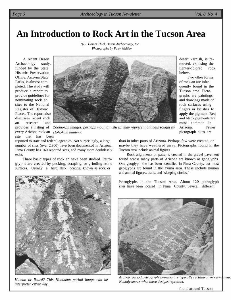
A recent Desert desert varnish, is re- Archaeology study, moved, exposing the funded by the State lighter-colored rock Historic Preservation below. Office, Arizona State Two other forms Parks, is almost com- of rock an are infre- pleted. The study will quently found in the produce a report to Tucson area. Picto- provide guidelines for graphs are paintings nominating rock an and drawings made on sites to the National rock surfaces using Register of Historic fingers or brushes to Places. The report also apply the pigment. Red discusses recent rock and black pigments are an research and most common in provides a listing of Zoomorph images, perhaps mountain sheep, may represent animals sought by Arizona. Fewer every Arizona rock an Hohokam hunters. pictograph sites are site that has been reported to state and federal agencies. Not surprisingly, a large number of sites (over 2,300) have been documented in Arizona. Pima County has 160 reported sites, and many more doubtlessly exist.
Three basic types of rock an have been studied. Petro- glyphs are created by pecking, scraping, or grinding stone surfaces. Usually a hard, dark coating, known as rock or Human or lizard? This Hohokam period image can be interpreted either way.
than in other parts of Arizona. Perhaps few were created, or maybe they have weathered away. Pictographs found in the Tucson area include animal figures.
Rock alignments or patterns created in the gravel pavement found across many parts of Arizona are known as geoglyphs. One geoglyph site has been identified in Pima County, but most geoglyphs are found in the Yuma area. These include human and animal figures, trails, and "sleeping circles."
Petroglyphs in the Tucson Area. About 120 petroglyph sites have been located in Pima County. Several different
Archaic period petroglyph elements are typically rectilinear or curvilinear. Nobody knows what these designs represent.
found around Tucson

October 1994 Archaeology in Tucson Newsletter Page 7
styles of petroglyphs can be found in the area around metropolitan Tucson. Petroglyphs thought to have been made by people during the Archaic period (6000-8000 B.C. to perhaps as late as A.D. 800) were created by direct percussion with a hammerstone.
Western Archaic petroglyph designs are typically abstract (not representing a known object). Common Archaic period designs include footprints, atlatls, a design resembling a centipede or corn stalk, grids, rakes, ladders, sectioned rectangles, and zigzags, to name a few. Archaic designs are found throughout Arizona and neighboring areas, suggesting that people may have traveled throughout the area, carving designs and observing those made by other people.
The later Hohokam people also created rock art, mostly petroglyphs, from about A.D. 800 to 1450. Again, most Hohokam petroglyph designs were created using the direct percussion technique.
Three basic types of Hohokam designs have been identified. Anthropomorphs are human figures, sometimes accompanied by artifacts such as bows and arrows or spears. Most anthropomorphs are stick figures, some with expanded torsos. Some are engaged in activities such as dancing or hunting. Zoomorphs are animal figures such as dogs or coyotes, deer, mountain lions, lizards, other unidentified four-legged animals, and snakes. Geometric images are very common and include circles, bull's-eyes, spirals, meandering lines, and areas of "dint" patterns.
Why Was Rock Art Made? The function of rock art is difficult to know. Studies of rock art have noted that the designs are often found near trails, close to places where wild plants were gathered and processed, and in hunting locations. The best current idea about rock art is that it played a role in various important rituals in the past.
A distinctive design found only at Ho- hokam sites is the pipette. These are bilaterally symmetrical, lobed designs that are believed to date to the Classic period (A.D. 1150 to 1450). These images may represent a Mesoamerican deity, perhaps similar to one known as Tlaloc. Further study might help unravel the meaning of rock art sites.
Locating and recording rock art sites be- comes more important as development occurs throughout the Tucson area. Classes on recording rock art have been offered through the Arizona Archaeological Society. Oppor- tunities to help protect sites can be found in the Arizona Site Steward Program, managed by the State Historic Preservation Office. Several rock art sites can be visited by the public in south-central Arizona, including Signal Peak in the Saguaro National Monu- ment and Painted Rocks State Historic Park
Pipette designs are found only in south-central Arizona and were created by the Hohokam people.
near Gila Bend. A variety of Hohokam geometric images adorn rocks near Picacho Peak.
Center for Desert Archaeology Archaeology in Tucson 3975 North Tucson Blvd. Tucson, AZ 85716
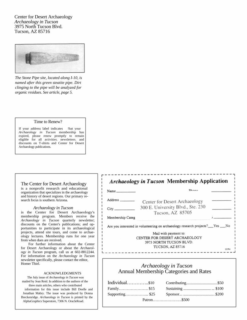
The Stone Pipe site, located along I-10, is named after this green steatite pipe. Dirt clinging to the pipe will be analyzed for organic residues. See article, page 5.
Time to Renew?
If your address label indicates !bat your Archaeology in Tucson membership has expired, please renew promptly to remain eligible for all activities. newsletters. and discounts on T-shirts and Center for Desert Archaeology publications.
The Center for Desert Archaeology is a nonprofit research and educational organization that specializes in the archaeology and history of desert regions. Our primary re- search focus is southern Arizona.
Archaeology in Tucson is the Center for Desert Archaeology's membership program. Members receive the Archaeology in Tucson quarterly newsletter; discounts on the Center's publications; and op- portunities to participate in its archaeological projects, attend site tours, and come to archae- ology lectures. Membership runs for one year from when dues are received.
For further information about the Center for Desert Archaeology or about the Archaeol- ogy in Tucson program, call us at 602-8812244. For information on the Archaeology in Tucson newsletter specifically, please contact the editor, Homer Thiel.
ACKNOWLEDGMENTS The July issue of Archaeology in Tucson was
mailed by Jean Reid. In addition to the authors of the three main articles, others who contributed
information for this issue include Bill Doelle and Jonathan Mabry. The issue was produced by Donna Breckenridge. Archaeology in Tucson is printed by the AlphaGraphics Superstore, 7306 N. OracleRoad.
Archaeology in Tucson Annual Membership Categories and Rates
Individual…………..$10 Contributing................................$50
Family…………………. $15 Sustaining ............................. ... $100
Supporting……………... $25 Sponsor... .............................. .$200 Patron………………….$500