Embed Size (px)
Citation preview
Archaeology as human ecology: Method and theory for a contextual approach
KARL W. BUTZER Henry Schultz Professor of Environmental Archeology The University of Chic.ago
Cambridge University Press Cambridge London New York New Rochelle Melbourne Sydney
Published by the Press Syndicate of the University of Cambridge The Pitt Building, Trumpington Street, Cambridge CB2 lRP 32 East 57th Street, New York, NY 10022, USA 296 Beaconsfield Parade, Middle Park, Melbourne 3206, Australia
© Cambridge University Press 1982
First published 1982
Printed in the United States of America
Library of Congress Cataloging in Publication Data Butzer, Karl W.
Archaeology of human ecology;
Includes index.
1. Environmental archaeology. 2. Human ecology. 3. Landscape assessment. I. Title. CCS!.B87 930.1 81-21576 AACR2 ISBN O 521 24652 0 hard covers ISBN O 521 28877 0 _p•pe,baek
For ELISABETH
Beethoven Op. 138 ("Leonore")
err ewmnm m,, xmr 71 rFMn« :rmrw 271157
Contents
Preface page xi
PART I Perspectives
1 Context in archaeology 3 Introduction Context and ecology Scales and dimensions of contextual archaeology Archaeology as archaeology
2 Environmental systems: spatial and temporal variability 14 Space and scale in ecology Biomes as environmental systems Equilibrium properties Scales of environmental variability Models for ecosystemic change Unique character of human ecosystems
PART II Foundations
3 Geo-archaeology I: basic principles Objectives Study components Techniques and procedures Ultimate collaborative goals
4 Geo-archaeology II: landscape context Sedimentary matrix
vii
Point depositional environments Linear depositional environments Areal depositional environments
35
43
viii Contents Contents ix
Geo-archaeological synthesis of microenvironments Retrieval of archaeobotanical information
Topographic matrix Paleobotanical interpretation
Terrain, soils, and biota Denclroecology and dendroclimatology
Regional matrix Human utilization of plants
Environmental shifts 11 Zoo-archaeology: faunas and animal procurement 191
5 Geo-archaeology Ill: stratigraphic context 67 Issues in archaeozoology
Stratigraphic nomenclature Taphonomy
Lithostratigraphy: site and setting Ecological evaluation of fossil assemblages
External correlations Hunters and their prey Domestication and fauna! change
6 Geo-archaeology N: site formation 77 Archaeological sediments PART III Synthesis A Pleistocene prototype: cave sediments
12 Spatial integration !: quantitative models for pattern An example of cave gee-archaeology: Cueva Morin
analysis 211 A Holocene prototype: village mounds Components, subsystems, and human ecosystems Examples of urban geo-archaeology: Giza and Axum
Spatial archaeology 7 Geo-archaeology V: site modification and destruction 98 Gravity models
Cultural transformation of archaeological residues van Thunen's model Preburial dispersal Central-place theory Postdepositiona! disturbance Resource-concentration models Geobiochemical modification
13 Spatial integration II: socioecological models for settle-Site destruction and artifact dispersal
ment analysis 230 Environmental modification of archaeological residues Scale settlement analysis
8 Geo-archaeology VI: human impact on the landscape 123 Large-scale mobility models for hunter-gatherers Human activity and the soil-sediment system Subsistence-settlement generalizations for hunter-Geo-archaeological indicators of soil erosion gatherers Soil erosion in the geo-archaeological record Spatial determinants for agricultural settlement A case study of accelerated soil erosion: Real versus perceived environments
Axum, Ethiopia 14 Spatial integration Ill: reconstruction of settlement
Land use and soil fertility 258 Geo-archaeological landscape features systems
Site location Landscape productivity and degradation Archaeological site survey
9 Archaeometry: prospecting, provenance, dating 157 A landscape approach to settlement survey Scope and purpose of archaeometry Reconstruction of settlement patterns: hunter-Subsoil prospecting gatherers . Materials identification, provenance, and technology Reconstruction of settlement patterns: agncultural Chronometric dating communities
10 Archaeobotany: vegetation and plant utilization 171 15 Diachronic systems I: cultural adaptation 279 The archaeobotanical record
x Contents
Temporal integration Cultural adaptation Dynamic modes of adaptive systems
16 Diachronic systems II: continuity and change Adaptive transformation in the Pleistocene record: -
hominization Holocene adaptive transformations: taming the
environment
Modifications of regional adaptive systems: historical periodicities
Overview and prospect
References Index
295
321 359
I I I i ! I
i ' !
Preface
I have chosen the title Archaeology as Human Ecology to emphasize the dynamic interactions between human groups or societies and their environments. This book is intended to provide an introduction to the methodology and theoretical framework for such a study. The central concept is the human ecosystem. This serves as an organizing principle to illuminate the interdependence of cultural and environmental variables, as well as an organizational framework within which to discuss the various scientific approaches critical to understanding the processes of such interaction. The context of the book's subtitle refers to both the locus of and the dynamic processes that define human ecology.
The first section, the introductory part of the book, explains and elaborates the ecosystem approach. A second section then develops the three subsidiary fields of study that contribute the substantive data critical to understanding prehistorical and historical human ecosystems: (a) geo-archaeology, the study and interpretation of sediments and physical landscapes; (b) archaeometry, the use of physical and chemical m€thods of measurement, including raw-material provenance, dating, and site prospecting; (c) bio-archaeology, the study of plant and animal remains that reflect subsistence activities as well as biotic environments.
The third and final section of the book integrates these components within a spatial framework as well as a temporal or diachronic framework. Spatial archaeology can be seen as a fourth field of study, although it is closely interwoven with the others. The spatial dimensions of component data, at different scales (micro, meso, macro), are developed in each chapter, and the spatial paradigm has been chosen to serve as one of the frameworks for synthesis in this final section. This is complemented, in the last two chapters, by theoretical and interpretative discussions within an adaptive paradigm. These deal with the
xi
Ji 40 Foundations .t
I ., farmers commonly had an impact on the soil-slope-stream system (see 1 Figure 2-2) that was both extensive and intensive and often was of ii
1 considerable duration. British agricultural landscapes of the Neolithic } and Bronze Age were crisscrossed by drainage ditches, partly leveled I by row terraces, bounded by earthen or stone walls, and dimpled by j burial mounds. Indians in southwestern North America dug irrigation t.•.
ditches, built dams, and reinforced river banks. In countless situations, .. ~ prehistorical planters and herders were able to disturb vegetation and 1 ground cover until a threshold was reached at which the amount and
speed of runoff were enhanced after rainstorms, filling in ditches and the like by sheetwash and gravity, and truncating or burying soil profiles. In the end, soil formation, slope processes, and stream behavior may have been modified sufficiently to leave a dear record of disturbance, possibly culminating in an episode of landscape degradation, with attendant accelerated soil erosion.
Techniques and procedures
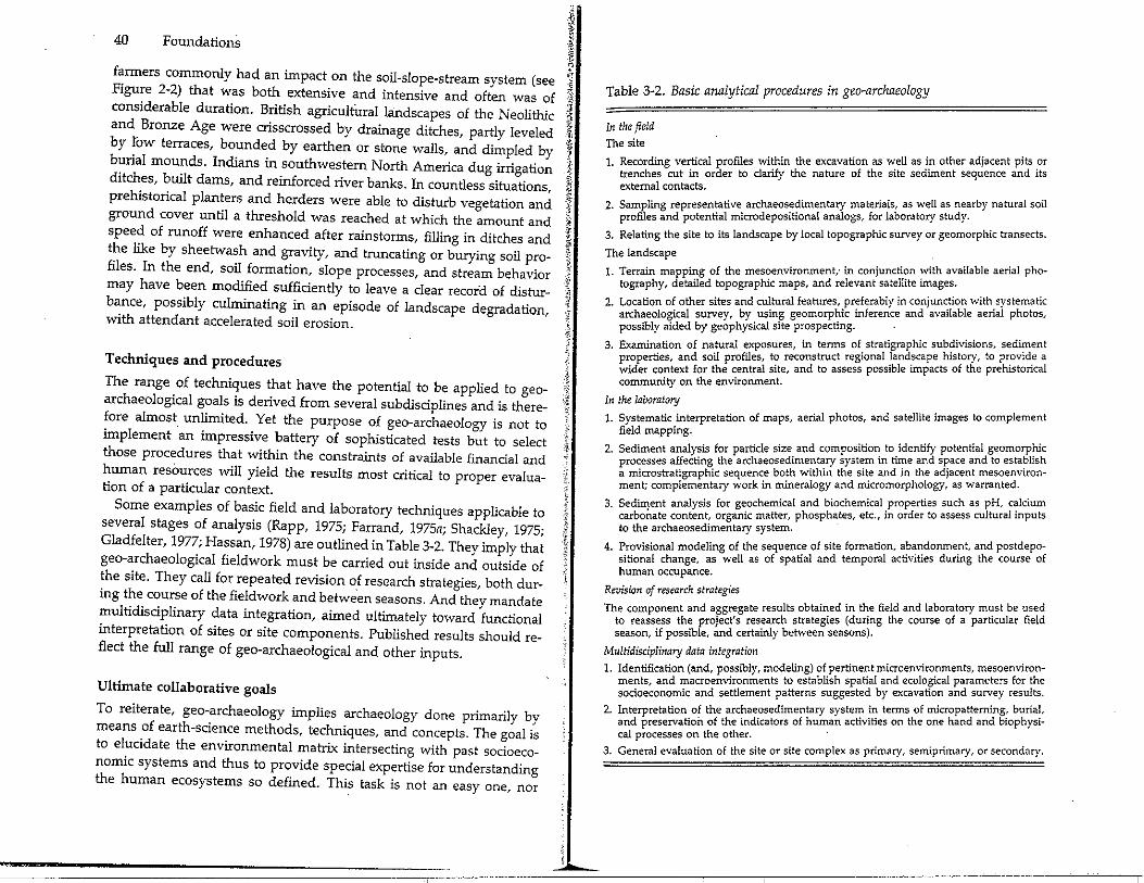
The range of techniques that have the potential to be applied to geoarchaeological goals is derived from several subdisciplines and is therefore almost unlimited. Yet the purpose of geo-archaeology is not to implement ·an impressive battery of sophisticated tests but to select those procedures that within the constraints of available financial and human resOurces will yield the results most critical to proper evaluation of a particular context.
Some examples of basic field and laboratory techniques applicable to several stages of analysis (Rapp, 1975; Farrand, 1975a; Shackley, 1975; Gladfelter, 1977; Hassan, 1978) are outlined in Table 3-2. They imply that geo-archaeological fieldwork must be carried out inside and outside of the site. They call for repeated revision of research strategies, both dur-ing the course of the fieldwork and between seasons. And they mandate multidisciplinary data integration, aimed ultimately toward functional interpretation of sites or site components. Published results should re-flect the full range of geo-archaeological and other inputs.
Ultimate collaborative goals
To reiterate, geo-archaeology implies archaeology done primarily by means of earth-science methods, techniques, and concepts. The goal is to elucidate the environmental matrix intersecting with past socioeconomic systems and thus to provide special expertise for understanding the human ecosystems so defined. This task is not an easy one, nor
Table 3-2. Basic analytical procedures in geo-archaeology
In the field The site
1 Recording vertical profiles within the excavation as well as in other adjacent pits _or · trenches cut in order to clarify the nature of the site sediment sequence and its
external contacts.
2 Sampling representative archaeosedimentary materials, as well as nearby natural soil · profiles and potential microdepositional analogs, for laboratory study. .
3. Relating the site to its landscape by local topographic survey or geomorph1c transects.
The landscape
1. Terrain mapping of the mesoenvironment,· in conjuncti?n ~ith available aerial pho-tography, detailed topographic maps, and relevant satellite unages. .
2 Location of other sites and cultural features, preferably in conjun~tion with_systematic · archaeological survey, by using geomorp~ic inference and available aenal photos,
possibly aided by geophysical site prospecting.
3 Examination of natural exposures, in terms of stratigraphic sub?ivisions, sedi~ent · rties and soil profiles to reconstruct regional landscape history, to pr_ov1d_e a e:t1e; context for the central site, and to assess possible impacts of the preh1stoncal
community on the environment.
In the laboratory
1. Systematic interpretation of maps, aerial photos, and satellite images to complement field mapping. . .
2. Sediment analysis for particle size and compositio~ to_identify potenha~geornor6J~1~ recesses affecting the archaeosedimentary system m time and Sf:ace an to esta_ is
; microstratigraphic sequence both within the site and in the ad1acent mesoenvuon· ment; complementary work in mineralogy and micromorphology, as warranted.
Sediment analysis for geochemical and biochemical properties such as pH, c~lcium 3· carbotlate content, organic matter, phosph~tes, etc., in order to assess cultural mputs
to the archaeosedimentary system.
4. Provisional modeling of the sequence of site formatioln. ati~~ntido~me_~tg, at~~ ~~~!:P~f sitional change, as well as of spatial and tempera ac VI es un human occupance.
Revision of research strategies
The component and aggregate results obtained in the field and laboratory m~st be ~s~j to reassess the project's research strategies (during the course of a particular 1e season, if possible, and certainly between seasons).
Multidisciplinary data integration . 1. Identification (and, possibly, modeling) of pertinei:t microenviro:1ments, mesoenviron
ments and macroenvironments to establish spatial and ecological parameters for the socioe~onomic and settlement patterns suggested by excavation and survey results.
2 Interpretation of the archaeosedimentary system in terms of micropatterning_, buria'., · and preservation of the indicators of human activities on the one hand and b1ophys1-
cal processes on the other. ·
3. General evaluation of the site or site complex as primary, semiprimary, or secondary.

122 Foundations ;~
comprises culturally filtered residues, either surface or sealed, that I have been subjected to minimal dispersal and disturbance. A semipri- j mary site consists of such surface or sealed materials that have been 'li subjecte_d to partial dispersal and/or disturbance, but for which relative ·~ associations remain essentially intact over at least part of the site. A 'f secondary site is composed of archaeological materials that have been ·,li} subj~cted to effective ~ispersal and/or co~plete disturbance, retaining ·1 few mformative associations or none. These definitions serve to de- 'ft scribe _aspects of .enviro~mental, no_t cultura~, context. The_ distinction is } essential to avmd a fairly pervasive concEf:ptual confus10n. Another .f.· qualification to Figure 7-16 is that it does n9' t include all permutations ,t.
. ~
of sealed, surface, primary, semiprimary, and secondary sites. Finally, i}-Figure 7-16 does not consider potential secondary cycles that expose ·t and possibly rebury archaeological residues. l
The geochemical flow diagram (Figure 7-16, bottom) deals with the ·i; essential preservation processes and products relevant to plant reM ,~ mains, bone, and bioch':mical residues, particularly_ as generated in Ji outputs B, C, and D (Figure 7-16, top) (1.e., affecting sealed sites). 'ii-' Organic residues are rarely preserved (or at least discernible) in the :i. case of a surface site. il
In combination, the two diagrams of Figure 7-16 provide a geo- ,j: archaeological classification for archaeological sites that is predicated on :i. th:ee environmental criteria: (a) surface versus sealed; (b) primary, semi- tr pnmary, or secondary; (c) the presence or absence of (and selective ,'Ii; preservation of) organic residues. For example, the content of an Egyp- i tian tomb might be BA' (primary, sealed, with complete organic preser- Al· vation), that of a Danish bog CB' (semiprimary, sealed, fairly complete .\t, organic preservation), that of a French river gravel DC' (secondary, ·J
.;., sealed, with some organic preservation), and that of an Archaic field il
:;:r:-scatter EE' (secondary, surface, essentially no organic preservation). 't-
in conclusion, it may be argued that a proper understanding of the { environmental modification of archaeological residues is or should be a ·* critical goal in geo-archaeological study. Unless these processes are first · elucidated, the cultural transformations may remain unnecessarily ambiguous or even undecipherable. Only when both the environmental and cultural contexts of a site are understood can sociocultural interpretation of the systemic context of a prehistorical community be attempted.
CHAPTER 8
Geo-archaeology VI: human impact on the landscape
Human activity and the soil-sediment system
The impacts of preindustrial human activities are concentrated in and around living areas, but these represent only a small part of a region. By focusing on sites, many archaeologists fail to appreciate the more diffuse but equally real impacts of people on the landscape at large. In the case of prehistorical foragers, these impacts may indeed by subtle and almost intangible, through the use of fire to facilitate hunting, local disturbance of vegetation, inadvertent dispersal of economic plants, and fauna! changes as a result of selective hunting pressures (Butzer, 1971a). But farmers and herders normally have significant and even dramatic influences on the environment.
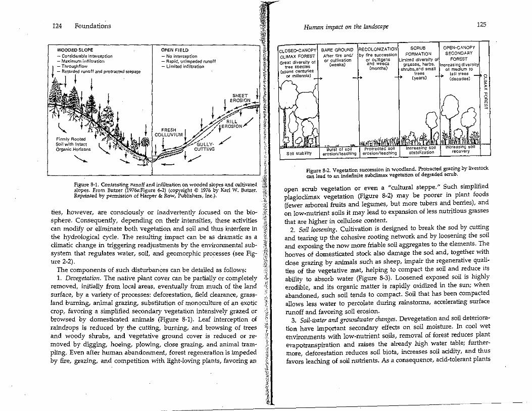
Central to this argument is that the vegetation cover and soil mantle provide a critical resource as well as a protective buffer between the atmosphere and the earth's crust. Under normal circumstances, in a humid landscape, rainfall is intercepted by taller plants, which break raindrop impact and prevent direct rainsplash on mineral soil. Organic leaf litter in various stages of decomposition covers the ground and creates a topsoil layer that cushions water impact, while also acting as a sponge to soak it up. The microfauna of the organic topsoil also maintain a spongy soil structure by converting organic residues into beneficial by-products, enhancing the aeration essential for good plant growth, and allowing water to infiltrate the soil. This diverts surface water from rapid runoff to slow lateral "throughflow" or to recharge the deeperseated groundwater. Meanwhile, the rooting network helps bind the soil. The net result is that surface runoff is reduced in amount and velocity, soil moisture is enhanced, and groundwater seepage is maintained, even during drier times of. the year (Figure 8-1). Stream discharge immediately after heavy storms is reduced or delayed, and dryseason flow is sustained. In this way, vegetation and soil not only condition productivity but also regulate the hydrological cycle. Human activi-123
124 Foundations
WOODED SLOPE
- Considerable interception - Maximum inflltration
J - Throughflow t - Retarded runoff and protracted seepage
ii t f •
Firmly Rooted Soil with Intact Organic Horizons
OPEN FIELD - No interception - Rapid, unimpeded runoff - Limited infiltration
SHEET i I EAOSION--4-
t --I ,:, t I t "1/s;:L / t/~'tEROSION
FRESH I )'/ / COLLUVIUM t ,_;?, ,../
1 i..... J1--sCLLY- / t ~ CUTTING
-· er:-". t / - t> f,.
'----------------'------------------' ;; - ,t,·
Figure 8-1. Contrasting runoff and infiltration on wooded slopes and cultivated ~ slopes. From Butzer (1976a:Figure 6-2) (copyright © 1976 by Karl W. Butzer. i Reprinted by permission of Harper & Row, Publishers, Inc.). ¥,;
ties, however, are consciously or inadvertently focused on the biosphere. Consequently, depending on their intensities, these activities can modify or eliminate both vegetation and soil and thus interfere in the hydrological cycle. The resulting impact can be as dramatic as a climatic change in triggering readjustments by the environmental subsystem that regulates water, soil, and geomorphic processes (see Figure 2-2).
The components of such disturbances can be detailed as follows: 1. Devegetation. The native plant cover can be partially or completely
removed, initially from local areas, eventually from much of the land surface, by a variety of processes: deforestation, field clearance, grassland burning, animal grazing, substitution of monoculture of an exotic crop, favoring a simplified secondary vegetation intensively grazed or browsed by domesticated animals (Figure 8-1). Leaf interception of raindrops is reduced by the cutting, burning, and browsing of trees and woody shrubs, and vegetative ground cover is reduced or removed by digging, hoeing, plowing, dose grazing, and animal trampling. Even after human abandonment, forest regeneration is impeded by fire, grazing, and competition with light-loving plants, favoring an
,:;r"
:!: ·if
:i C,,'•
i' ft
' l ,tl ::~:
Human impact on the landscape 125
CLOSED-CANOPY BARE GROUND RECOLONIZATION SCRUB OPEN-CANOPY cUMAX FOREST After fire and/ by fire succession FORMATION SECONDARY
Great diversity of tree species
(spans centuries or millemia)
or cultivation or cultigens Limited diversity of FOREST (weeks) and weeds grasses, herbs, Increasing diversity
(months) shrubs, and small of medium to
Soil stabil'ity Protracted soil
erosion/leaching
trees tall trees (years) (decades)
Figure 8-2. Vegetation succession in woodland. Protracted grazing by livestock can lead to an indefinite subclimax vegetation of degraded scrub.
open scrub vegetation or even a "cultural steppe." S_uch simplified plagioclimax vegetation (Figure 8-2) may be poorer m pla~t foods (fewer arboreal fruits and legumes, but more tubers and bernes), and on low-nutrient soils it may lead to expansion of less nutritious grasses that are higher in cellulose content.
2. Soil loosening. Cultivation is designed to break the sod by cutting and tearing up the cohesive rooting network and by loosening the soil and exposing the now more friable soil aggregates to the elements. The hooves of domesticated stock also damage the sod and, together with close grazing by animals such as sheep, impair the regenerative qualities of the vegetative mat, helping to compact the soil and reduce its ability to absorb water (Figure 8-3). Loosened exposed soil is highly erodible, and its organic matter is rapidiy oxidized in the sun; when abandoned, such soil tends to compact. Soil that has been compacted allows less water to percolate during rainstorms, accelerating surface runoff and favoring soil erosion.
3. Soil-water and groundwater changes. Devegetation and soil deterioration have important secondary effects on soil moisture. In cool wet environments with low-nutrient soils, removal of forest reduces plant evapotranspiration and raises the already high water table; furthermore deforestation reduces soil biota, increases soil acidity, and thus favo:S leaching of soil nutrients. As a consequence, acid-tolerant plants
126 Foundations
01 02
A1
A2 </)
z 0 B
N
a:
0
:i:
Leaf litter Partly~decomposed organic debris
Organic, mineral topsoil
Leached topsoil
Clay-enriched subsoil
Sandy/stony, partly-decomposed parent material
Intact substrate
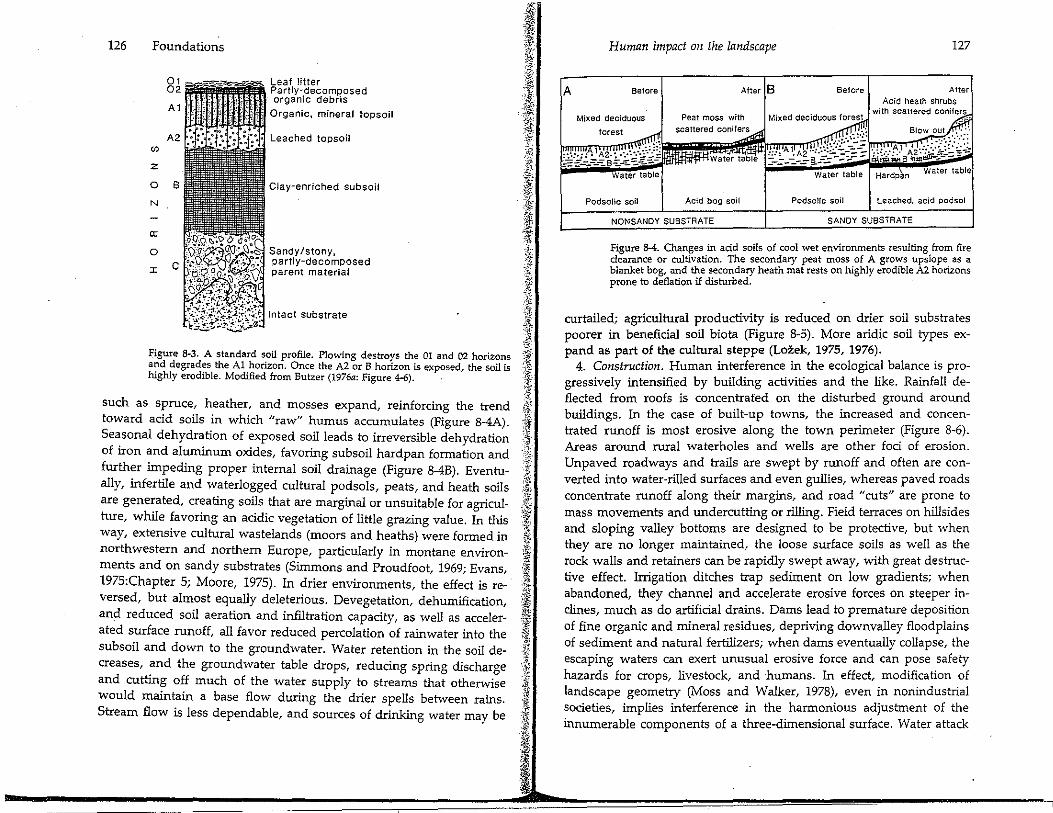
Figure 8~3. A standard soil profile. Plowing destrors th~ 01 and 02 horiz?~s and degrades the Al horizon. Once the A2 or B honzon is exposed, the soil 1S highly erodible. Modified from Butzer (1976a: Figure 4-6).
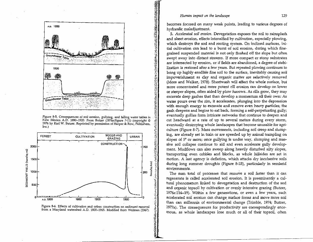
such as spruce, heather, and mosses expand, reinforcing the trend toward acid soils in which "raw" humus accumulates (Figure 8-4A). Seasonal dehydration of exposed soil leads to irreversible dehydration of iron and aluminum oxides, favoring subsoil hardpan formation and further impeding proper internal soil drainage (Figure 8-4B). Eventually, infertile and waterlogged cultural podsols, peats, and heath soils are generated, creating soils that are marginal or unsuitable for agriculture, while favoring an acidic vegetation of little grazing value. In this way, extensive cultural wastelands (moors and heaths) were formed in northwestern and northern Europe, particularly in montane environments and on sandy substrates (Simmons and Proudfoot, 1969; Evans, 1975:Chapter 5; Moore, 1975). In drier environments, the effect is reversed, but almost equally deleterious. Devegetation, dehumification, and reduced soil aeration and infiltration capacity, as well as accelerated surface runoff, all favor reduced percolation of rainwater into the subsoil and down to the groundwater. Water retention in the soil decreases, and the groundwater table drops, reducing spring discharge and cutting off much of the water supply to streams that otherwise would maintain a base flow during the drier spells between rains. Stream flow is less dependable, and sources of drinking water may be
A
Human impact on the landscape 127
Before After B Before After Acid heath shrubs
Mixed deciduous
forest
Peat moss with Mixed deciduous forest with scattered conifers
~-~~::: ~~~ ~::~ :::·'j~~ water table
Podsolic soil Acid bog soil Podsolic soil Leached, acid podsol
NONSANDY SUBSTRATE SANDY SUBSTRATE
Figure 8-4. Changes in acid soils of cool wet environments resulting from fire clearance or cultivation. The secondary peat moss of A grows upslope_ as a blanket bog, and the secondary heath mat rests on highly erodible .A2 honzons prone to deflation if disturbed. ·
curtailed; agricultural productivity is reduced on d~e; soil substrates poorer in beneficial soil biota (Figure 8-5). More andic soil types ex-pand as part of the cultural steppe (Lo~ek, 1975, 1976). .
4. Construction. Human interference m the ecological balance 1s progressively intensified by building activities and the like. Rainfall deflected from roofs is concentrated on the disturbed ground around buildings. In the case of built-up towns, the inc~eased an_d concentrated runoff is most erosive along the town penmeter (Figure 8-6). Areas around rural waterholes and wells are other foci of erosion. Unpaved roadways and trails are swept by runoff and often are converted into water-rilled surfaces and even gullies, whereas paved roads concentrate runoff along their margins, and road "cuts" are prone to mass movements and undercutting or rilling. Field terraces on hillsides and sloping valley bottoms are designed to be protective, but when they are no longer maintained, the loose surface so1~s as well as the rock walls and retainers can be rapidly swept away, with great destructive effect. Irrigation ditches trap sediment on low gradients; wh'.'n abandoned, they channel and accelerate erosive forces on steeper mclines much as do artificial drains. Dams lead to premature deposition of fin~ organic and mineral residues, depriving downvailey floodplains of sediment and natural fertilizers; when dams eventually collapse, the escaping waters can exert unusual erosive force and can ~ose _safety hazards for crops, livestock, and ·humans. In effect, modificat10n of landscape geometry (Moss and Walker, 1978)'. even in nonindustrial societies, implies interference in the harmonious adJUStment of the innumerable components of a three-dimensional surface. Water attack
2000
'ie ~ ,,; C 1500
.§.
" ~ w ;: 1000 ... z w ,e 0
500 w "'
0
A.O. 1880
1920
.. , ....•. ,;,-.,,
,j,:/>i
I. I 4: \;if
I ¥._'1,{ ·'&i 'fi: fl/i ·i~ ;l
"i;{;,,
!" .~ ·t '.f ,·1 ·}'I: ·'.$. .;._f,.
;J ,, & l I oft'., ·.:.~ ,_,. fJ
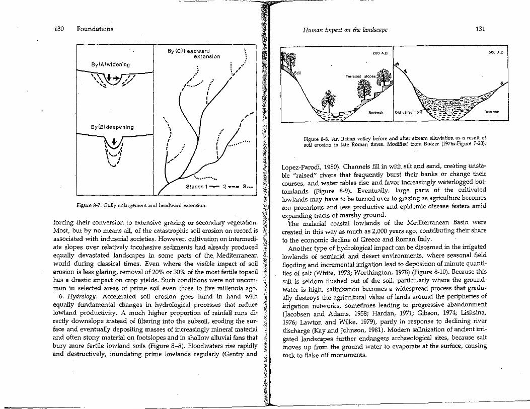
Figure 8-5. Consequences of soil erosion, gullying, and falling water tables in )$ New Mexico A.D. 1880-1920. From Butzer {1976a:Figure 7-11) (copyright © :i~.:.:·: 1976 by Karl W. Butzer. Reprinted by permission of Harper & Row, Publishers, ·.;,6
~ I FOREST CULTIVATION WOOOSAND
GRAZING
CONSTRUCTION--_
URBAN
700
350
---___ ....... A.O. 1800 ===::::-=~--~-:,-:::sa"o,--~--:.,9:':o::o-~-~-...,,-=9'::50:--~o
Figure 8-6. Effects of cultivation and urban construction on sediment removal from a Maryland watershed A.O. 1800-1965. Modified from Wolman (1967).
I ·I! ¾', it
-,.:'!, ·-,.;.:
j ] § 0 ~-'.
~ .Z. l J
..:··
Human impact on the landscape 129
becomes focused on many weak points, leading to various degrees of hydraulic maladjustment.
5. Accelerated soil erosion, Devegetation exposes the soil to rainsplash and sheet erosion, effects intensified by cultivation, especiaJly plowing, which destroys the sod and rooting system, On inclined surfaces, initial cultivation can lead to a burst of soil erosion, during which finegrained suspended material is not only flushed off the slope but often swept away into distant streams, If more compact or stony substrates are intersected by erosion, or if fields are abandoned, a degree of stabilization is restored after a few years. But repeated plowing continues to bring up highly erodible fine soil to the surface, inevitably causing soil impoverishment as clay and organic matter are selectively removed (Moss and Walker, 1978), Sheetwash will affect the whole surface, but more concentrated and more potent rill erosi9n can develop on lower or steeper slopes, often aided by plow furrows. As rills grow, they may excavate deep gashes that then develop a momentum all their own: As water pours over the rim, it accelerates, plunging into the depression with enough energy to excavate and remove even heavy particles; the gash deepens and begins to eat back, forming a self-perpetuating gully; eventually gullies form intricate networks that continue to deepen and cut headward at a rate of up to several meters during every storm, eventually destroying whole landscapes that become unusable for agriculture (Figure 8-7). Mass movements, including soil creep and slumping, are already set in train or are speeded up by animal trampling on slopes of 5° or more; once gullying is under way, slumping and massive soil collapse continue to aid and even accelerate gully development, Mudflows can also sweep along heavily disturbed silty slopes, transporting even cobbles and blocks, as whole hillsides are set in motion, A last agency is deflation, which attacks dry incohesive soils during long summer droughts (Figure 8-lB), particularly in semiarid environments.
The sum total of processes that remove a soil faster than it can regenerate is called accelerated soil erosion, It is preeminently a cultural phenomenon linked to devegetation and destruction of the sod and organic topsoil by cultivation or overly intensive grazing (Butzer, 1976a:114-19), _Within a few generations, or even a few years, such accelerated soil erosion can change_ surface forms and move more soil than can millennia of envirorunental change (Trimble, 1974; Butzer, 1977a). The consequences for productivity are correspondingly enormous, as whole landscapes lose much or all of their topsoil, often
130 Foundations
By(A)widening
By (B) deepening
· ..
By (C) headward extension
.. ,,· .. -· _, .. · , ..... ,
I I I
... ...
I , I I I
,,,--··
. ,-· : , ., ,
I I
,, ...
Stages 1- 2 --- 3-...
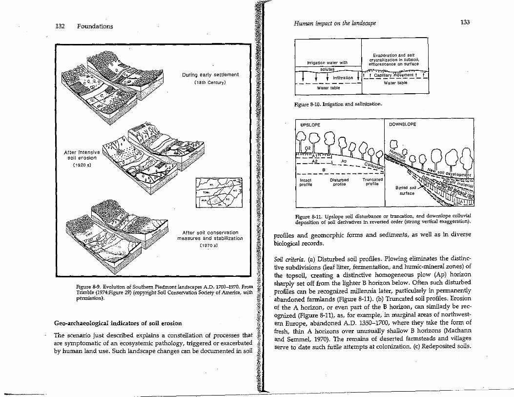
Figure 8-7. Gully enlargement and headward extension.
i '<'
J\i ~-
$ j :11 forcing their conversion to extensive grazing or secondary vegetation. ~-
Most, but by no means all, of the catastrophic soil erosion on record is j associated with industrial societies. However, cultivation on interrnedi- l ate slopes over relatively incohesive sediments had already produced ·~ equally devastated landscapes in some parts of the. Mediterranean j, world during classical times. Even where the visible impact of soil 'Jj erosion is less glaring, removal of 20% or 30% of the most fertile topsoil i has a drastic impact on crop yields. Such conditions were not uncom- 'c\
f..l man in selected areas of prime soil even three to five millennia ago, 1;
6. Hydrology. Accelerated soil erosion goes hand in hand with ;i .k equally fundamental changes in hydrological processes that reduce -~ ;,~
lowland productivity. A much higher proportion of rainfall runs di- ~
rectly downslope instead of filtering into the subsoil, eroding the sur- :, face and eventually depositing masses of increasingly mineral material :~ and often stony material on footslopes and in shallow alluvial fans that ] bury more fertile lowland soils (Figure 8-8). Floodwaters rise rapidly ! and destructively, inundating prime lowlands regularly (Gentry and 1 ~-
~ r~ ~-! ~
:i ~ ;.
Human impact on the landscape 131
200 A.O.
Figure 8-8. An Italian valley before and_ after stream alluviation a~ a result of soil erosion in late Roman times. Modified from Butzer (1976a:F1gure 7-20).
Lopez-Parodi, 1980). Channels fill in with silt and sand, creating unstable "raised" rivers that frequently burst their banks or change their courses, and water tables rise and favor increasingly waterlogged bottomlands (Figure 8-9). Eventually, large parts of the cultivated lowlands may have to be turned over to grazing as agriculture becomes too precarious and less productive and epidemic disease festers amid expanding tracts of marshy ground.
The malarial coastal lowlands of the Mediterranean Basin were created in this way as much as 2,000 years ago, contributing their share to the economic decline of Greece and Roman Italy.
Another type of hydrological impact can be discerned in the irrigated lowlands of semiarid and desert environments, where seasonal field flooding and incremental irrigation lead to deposition of minute quantities of salt (White, 1973; Worthington, 1978) (Figure 8-10). Because this salt is seldom flushed out of the soil, particularly where the groundwater is high, salinization becomes a widespread process that gradually destroys the agricultural value of lands around the peripheries of irrigation networks, sometimes leading to progressive abandonment (Jacobsen and Adams, 1958; Hardan, 1971; Gibson, 1974; Lisitsina, 1976; Lawton and Wilke, 1979), partly in response to declining river discharge (Kay .and Johnson, 1981). Modem salinization of ancient irrigated landscapes further endangers archaeological sites, because salt moves up from the ground water to evaporate at the surface, causing rock to flake off monuments.
500 A.O.
132 Foundations
After intensive soil erosion
(1920 s)
During early settlement
(18th Century)
After soil conservation measures and stabilization
(1970 s)
Figure 8-9. Evolution of Southern Piedmont landscapes A.O. 1700-1970. From Trimble (1974:Figure 29) (copyright Soil Conservation Society of America, with pemtission).
Geo-archaeological indicators of soil erosion
The scenario just described explains a constellation of processes that are symptomatic of an ecosystemic pathology, triggered or exacerbated by human land use. Such landscape changes can be documented in soil
Human impact on the landscape
Evaporation and salt
Irrigation water with crystallization in subsoil, efflorescence on surface
solutes
! i { Infiltration ! "t" · ·,. C~Pi11ary ·movement t .. f -----------
Water table
Figure 8-10. Irrigation and salinization.
UPSLOPE
___ Aj_ __ l
___ A~--1 AP C ----- 0/fl.Jt.,r _____ e ______ --...:.u'!!..
Intact profile
Disturbed proflle
Truncated profile
Water table
DOWNSLOPE
133
Figure 8-11. Upslope soil disturbance or truncation, and downslope colluvial deposition of soil derivatives in reversed order (strong vertical exaggeration).
profiles and geomorphic forms and sediments, as well as in diverse biological records.
Soil criteria. (a) Disturbed soil profiles. Plowing eliminates the distinctive subdivisions (leaf litter, fermentation, and humic-mineral zones) of the topsoil, creating a distinctive homogeneous plow (Ap) horizon sharply set off from the lighter B horizon below. Often such disturbed profiles can be recognized millennia later, particularly in permanently abandoned farmlands (Figure 8-11). (b) Truncated soil profiles. Erosion of the A horizon, or even part of the B horizon, can similarly be recognized (Figure 8-11), as, for example, in marginal areas of northwestern Europe, abandoned A.O. 1350-1700, where they take the form of fresh, thin A horizons over unusually shallow B horizons (Jv!achann and Semmel, 1970). The remains of deserted farmsteads and villages serve to date such futile attempts at colonization. (c) Redeposited soils.
134 Foundations I .... .
.
..
Floodplain
...... · .• . : ... Soil
... : . : .. :: . = -· · · ·. ·channel !ens ·: .. Wash lens
Flood silt's :.. -8
.-1 - - - 01
- --:: _....: - ..... ~.o·~ ...... -
-· •. · ... .·.·. - -ii\
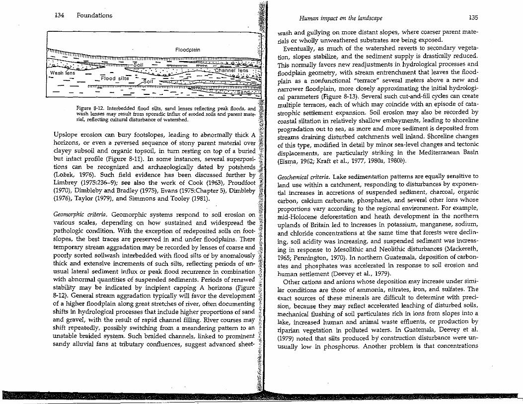
Figure 8-12. Interbedded flood silts, sand lenses reflecting peak floods, and J wash lenses may result from sporadic influx of eroded soils and parent mate- ,,ii rial, reflecting cultural disturbance of watershed. ·,~ .,,
j?,> Upslope erosion can bury footslopes, leading to abnormally thick A ~ horizons, or even a reversed sequence of stony parent !Ilaterial over J clayey subsoil and organic topsoil, in turn resting on top of a buried .'{ but intact profile (Figure 8-11). In some instances, several superposi- f lions can be recognized and archaeologically dated by potsherds ,.J (Lozek, 1976). Such field evidence has been discussed further by .i\t. Limbrey (1975:236-9); see also the work of Cook (1963), Proudfoot J (1970), Dimbleby and Bradley (1975), Evans (1975:Chapter 5), Dimbleby iJl\ (1976), Taylor (1979), and Simmons and Tooley (1981). ,.
Iii/. 'o, .. '-
Geomorphic criteria. Geomorphic systems respond to soil erosion on '$ ·:y; various scales, depending on how sustained and widespread the .• , pathologic condition. With the exception of redeposited soils on foot- .t slopes, the best traces are preserved in and under floodplains. There } temporary stream aggradation may be recorded by lenses of coarse and .l! poorly sorted soilwash interbedded with flood silts or by anomalously /i thick and extensive increments of such silts, reflecting periods of un- :ff, usual lateral sediment influx or peak flood recurrence in combination I) with abnormal quantities of suspended sediments. Periods of renewed }
"' stability may be indicated by incipient capping A horizons (Figure :;\'. 8-12). General stream aggradation typically will favor the developm~nt J of a higher floodplain along great stretches of river, often documenting i shifts in hydrological processes that include higher proportions of sand J and gravel, with the result of rapid channel filling. River courses may ,i shift repeatedly, possibly switching from a meandering pattern to an f unstable braided system. Such braided channels, linked to prominent ~ sandy alluvial fans at tributary confluences, suggest advanced sheet- ii
! 1 1 ~
Iii '.ti(
I
Human impact on the landscape 135
wash and gullying on more distant slopes, where coarser parent materials or wholly unweathered substrates are being exposed.
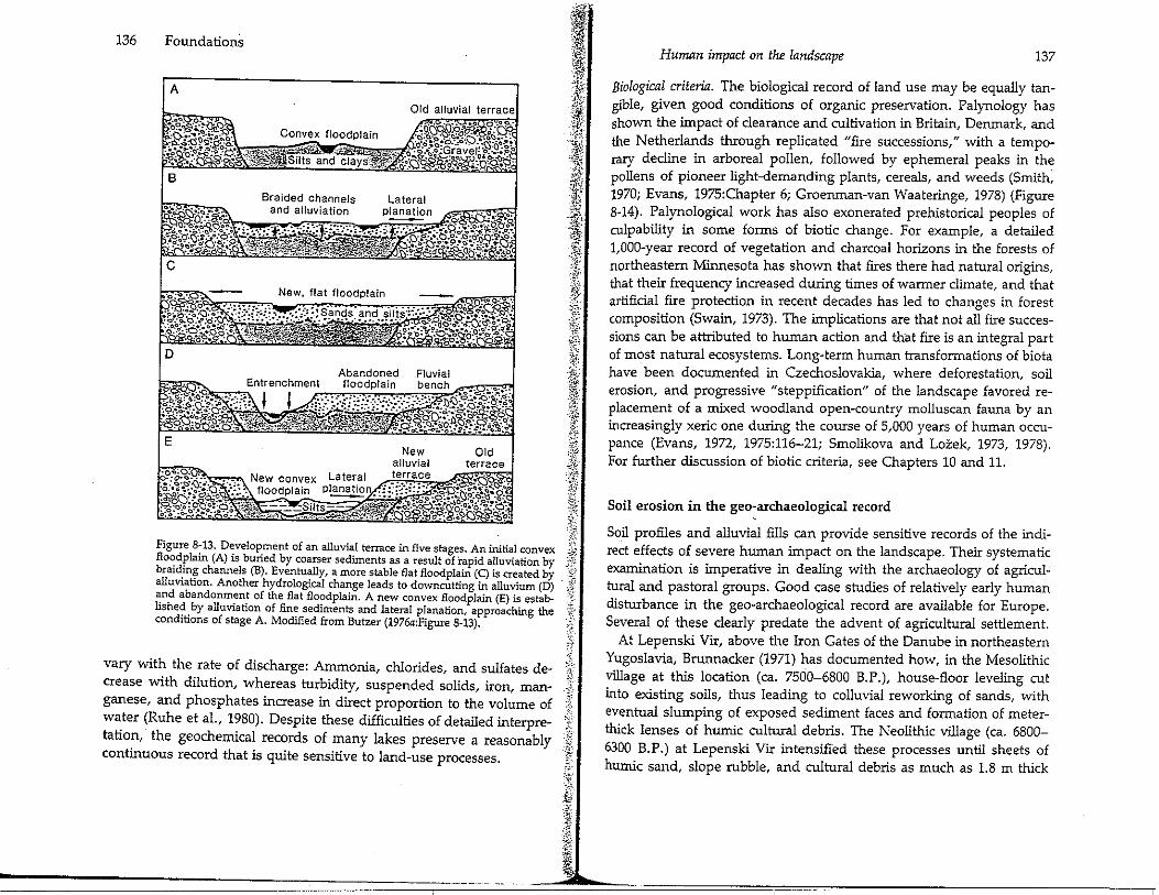
Eventually, as much of the watershed reverts to secondary vegetation, slopes stabilize, and the sediment supply is drastically reduced. This normally favors new readjustments in hydrological processes and floodplain geometry, with stream entrenchment that leaves the floodplain as a nonfunctional "terrace" sever~l ~eters a~o:'~ a new an~ narrower floodplain, more closely approxunating the uutial hydrological parameters (Figure 8-13). Several such cut-and-fill cycles can create multiple terraces, each of which may coincide with an episode of catastrophic settlement expansion. Soil erosion may also be recorded by coastal siltation in relatively shallow embayments, leading to shoreline progradation out to sea, as more and more sediment is deposited from streams draining disturbed catchments well iniand. Shoreline changes of this type, modified in detail by minor sea-level changes and tectonic displacements, are particularly striking in the Mediterranean Basin (Eisma, 1962; Kraft et al., 1977, 1980a, 1980b).
Geochemical criteria. Lake sedimentation patterns are equally sensitive to land use within a catchment, responding to disturbances by exponential increases in accretions of suspended sediment, charcoal, organic carbon, calcium carbonate, phosphates, and several other ions whose proportions vary according to the regional environment. For example, mid-Holocene deforestation and heath development in the northern uplands of Britain led to increases in potassium, manganese, sodium, and chloride concentrations at the same time that forests were declining, soil acidity was increasing, and suspended sediment was increasing in response to Mesolithic and Neolithic disturbances (Mackereth, 1965; Pennington, 1970). In northern Guatemala, deposition of carbonates and phosphates was accelerated in response to soil erosion and human settlement (Deevey et al., 1979).
Other cations and anions whose deposition may increase under similar conditions are those of ammonia, nitrates, iron, and sulfates. The exact sources of these minerals are difficult to determine with precision, because they may reflect accelerated leaching of disturbed soils, mechanical flushing of soil particulates rich in ions from slopes into a lake, increased human and animal waste effluents, or production by riparian vegetation in polluted waters. In Guatemala, Deevey et al. (1979) noted that silts produced by construction disturbance were unusually low in phosphorus. Another problem is that concentrations
136 Foundations
A
B
Lateral
C
,-!fl :~, ·~ }TI: ~i~! I: i!!: .;'1}
JJ .;~s .~f
I -! 't~' ii -1;,
::r.:-.-.5:!-~ i· t; tV:
.i;: 0~ '.if ; i t l
Figure 8-13. Development of an alluvial terrace in five stages. An initial convex ~
bflo~ddplainh(A) is
1bu(Bri)edEby ctuoaallrser sedimentsb
1asfla,eflsult of
1 rapid alluviation by ,:.:_-.:.·,
ra1 !n~ c anne s . ven y, a more sta e at oodp ain (C) is created by · alluviation. Another hydrological change leads to downcutting in alluvium (D) - '(j
and abandonment of the flat floodplain. A new convex floodplain (E) is estab- 1-lishe~. by alluviation of fin: sediments and lateral planation, approaching the f conditions of stage A. Modified from Butzer (1976a:Figure 8-13). :,
~{-·"i'.
vary with the rate of discharge: Ammonia, chlorides, and sulfates de- 1; crease with dilution, whereas turbidity, suspended solids, iron, man- J ganese, and phosphates increase in direct proportion to the volume of i.i water (Ruhe et al., 1980). Despite these difficulties of detailed interpre- ·
latiotinn, the geochdemhica~ rec~rds of _many la1
keds preserve a reasonably &;_
con uous recor t at 1s qmte sensitive to an -use processes. :..
Human impact on the landscape 137
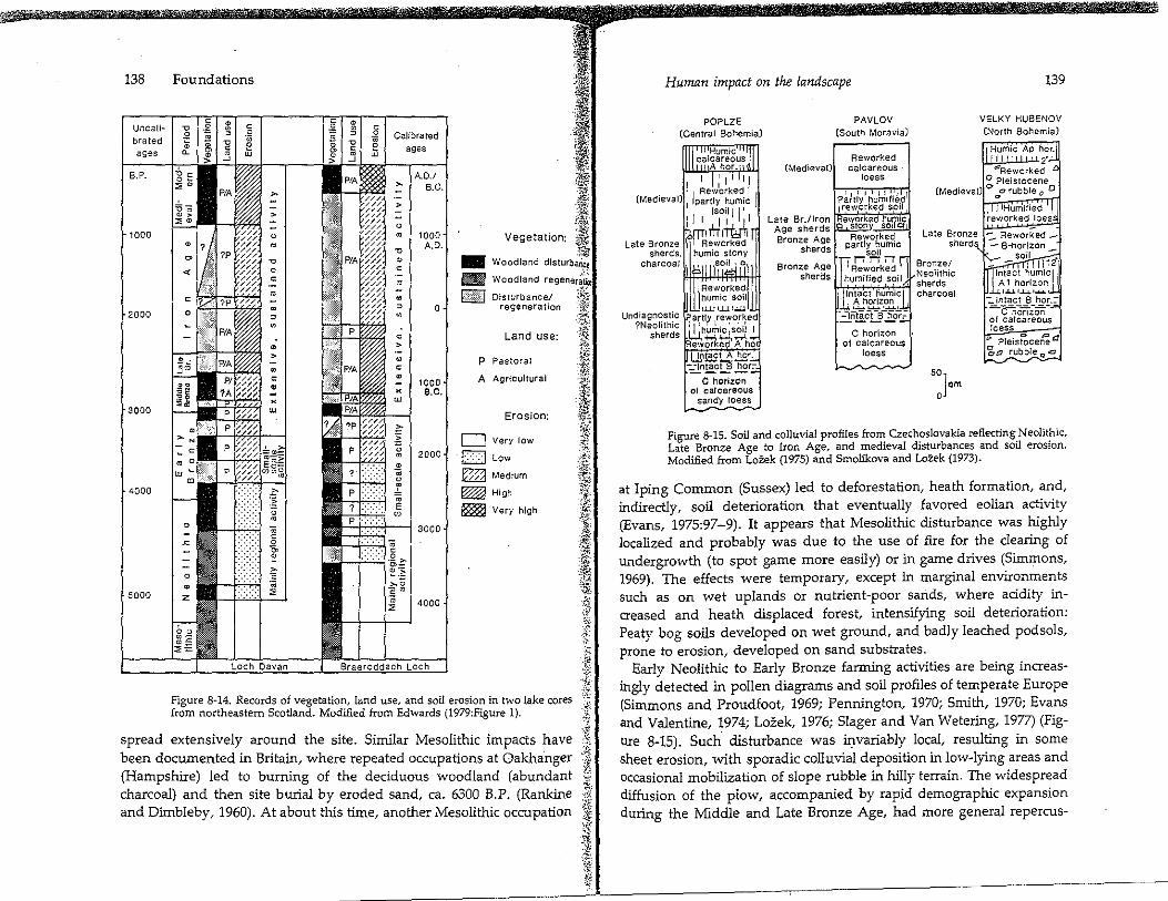
Biological criteria. The biological record of land use may be equally tangible, given good conditions of organic preservation. Palynology has shown the impact of clearance and cultivation in Britain, Denmark, and the Netherlands through replicated "fire successions," with a temporary decline in arboreal pollen, followed by ephemeral peaks in the pollens of pioneer light-demanding plants, cereals, and weeds (Smith; 1970; Evans, 1975:Chapler 6; Groenman-van Waateringe, 1978) (Figure 8-14). Palynological work has also exonerated prehistorical peoples of culpability in some forms of biotic change. For example, a detailed 1,000-year record of vegetation and charcoal horizons in the forests of northeastern Minnesota has shown that fires there had natural origins, that their frequency increased during times of wanner climate, and that artificial fire protection in recent decades has led to changes in forest composition (Swain, 1973). The implications are that not all fire successions can be attributed to human action and that fire is an integral part of most natural ecosystems. Long-term human transformations of biota have been documented in Czechoslovakia, where deforestation, soil erosion, and progressive "steppification" of the landscape favored replacement of a mixed woodland open-country molluscan fauna by an increasingly xeric one during the course of 5,000 years of human occupance (Evans, 1972, 1975:116-21; Smolikova and Lozek, 1973, 1978). For further discussion of biotic criteria, see Chapters 10 and 11.
Soil erosion in the geo-archaeological record
Soil profiles and alluvial fills can provide sensitive records of the indirect effects of severe human impact on the landscape. Their systematic examination is imperative in dealing with the archaeology of agricultural and pastoral groups. Good case studies of relatively early human disturbance in the geo-archaeological record are available for Europe. Several of these clearly predate the advent of agricultural settlement.
At Lepenski Vir, above the Iron Gates of the Danube in northeastern Yugoslavia, Brunnacker (1971) has documented how, in the Mesolithic village al this location (ca. 7500-6800 B.P.), house-floor leveling cut into existing soils, thus leading lo colluvial reworking of sands, with eventual slumping of exposed sediment faces and formation of meterthick lenses of humic cultural debris. The Neolithic village (ca. 6800-6300 B.P.) at Lepenski Vir intensified these processes until sheets of humic sand, slope rubble, and cultural debris as much as 1.8 m thick
138
Uncali~ brated ages
8.P.
1000
2000
~000
4000
5000
Foundations
Calibrated ages
A.O./ B.C.
1000 A.O.
0
1000 e.c.
2000
4000
--Hi&)
p
A
D D
i~· ,I ~
1'!!.;r,. ft L~"$" tW' ;~
:f.! ,,. Vegetation: ~ij·
-~
Woodland disturbarict .):':.
Woodland regeneriiu"
Disturbance/ .:.;~•~. '..: •. ·• regeneration 1::
·.~ Land use: ':8:
Pastoral
Agr!cu!tural
Erosion:
Very low
Low
'ri
'" J; "" I •!!)· ,i:;,:. ~-· ~{
_.;i k::::;a Medium t ·,~:
''if': High
Very high ;'@
i ·~· :y,;i; ~{}!g~ '}, ·-9. ,, :; -;~~
-fi
l Figure 8~ 14. Records of vegetation, land use, and soil erosion in two lake cores -i from northeastern Scotland. Modified from Edwards (1979:Figure 1). c,.:
spread extensively around the site. Similar Mesolithic impacts have l been documented in Britain, where repeated occupations at Oakha.nger i.: (Hampshire) led to burning of the deciduous woodland (abundant e charcoal) and then site burial by eroded sand, ca. 6300 B.P. (Rankine }· and Dimbleby, 1960). At about this time, another Mesolithic occupation j
,.i l 4;.; .,
Human impact on the landscape
POPLZE PAVLOV (Central Bohemia) (South Moravia)
Reworked (Medieval) calcareous
139
VELKY HUBENOV (North Bohemia)
Humic AP hor. I 2· ""Reworked
loess 0 Pleistocene (Medieval) e>
0c, rubble O O
Late Bronze sherds,
charcoal
UndiagnosUc ?Neolithic
sherds
Late Br./lron Age sherds Bronze Age
sherds
Late Bronze sherds
Bronze Age Bronze/ sherds Neolithic 1,y_...,,_...,..,,.ci sherds
Intact humic charcoal A horizon
.:!.~icUl'~'r,. C horizon
of calcareous foess
so] om 0
1.u.1..1...1., ...... ,
-:.. Intact B hor.:--C'liori'zori of calcareous !oess
" Pleis!ocerfea '2.-a rubble Q .ei
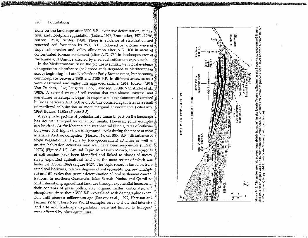
Figure 8-15. Soil and colluvial profiles from Czechoslovakia reflecting Neolithic, Late Bronze Age to Iron Age, and medieval disturbances and soil erosion. Modified from LoZek (1975) and Smolfkova and Lotek (1973).
at !ping Common (Sussex) led to deforestation, heath formation, and, indirectly, soil deterioration that eventually favored eolian activity (Evans, 1975:97-9). It appears that Mesolithic disturbance was highly localized and probably was due to the use of fire for the clearing of undergrowth (to spot game more easily) or in game drives (Simmons, 1969). The effects were temporary, except in marginal environments such as on wet uplands or nutrient-poor sari.ds, where acidity increased and heath displaced forest, intensifying soil deterioration: Peaty bog soils developed on wet ground, and badly leached podsols, prone to erosion, developed on sand substrates.
Early Neolithic to Early Bronze farming activities are being increasingly detected in pollen diagrams and soil profiles of temperate Europe (Simmons and Proudfoot, 1969; Pennington, 1970; Smith, 1970; Evans and Valentine, 1974; Lozek, 1976; Slager and Van Wetering, 1977) (Figure 8-15). Such· disturbance was invariably local, resulting in some sheet erosion, with sporadic colluvial deposition in low-lying areas and occasional mobilization of slope rubble in hilly terrain. The widespread diffusion of the plow, accompanied by rapid demographic expansion during the Middle and Late Bronze Age, had more general repercus-
··~ 140 Foundations )~ ~f
sions on the landscape after 3500 B.P.: extensive deforestation, cultiva-,1 lion, and floodplain aggradation (Lozek, 1976; Brunnacker, 1971, 1978b;lf Butzer, 1980a; Richter, 1980). There is evidence of stabilization and ;I renewed soil formation by 2500 B.P., followed by another wave of]! slope soil erosion and valley alluviation after A.O. 100 in areas of j concentrated Roman settlement (after A.O. 750 in landscapes east of ,'ii the Rhine and Danube affected by medieval settlement expansion). }I
'rli~ In the Mediterranean Basin the picture is similar, with local evidence ,ft
of vegetation disturbance (oak woodlands degraded to Mediterranean I scrub) beginning in Late Neolithic or Early Bronze times, but becoming '~ commonplace between 3800 and 3100 B.P. in different areas, as soils;{ were destroyed and valley fills aggraded (Eisma, 1962; Judson, 1963; 'J'i[ Van Zuidam, 1975; Faugeres, 1979; Davidson, 1980b; Van Andel et al., J' 1980). A second wave of soil erosion that was almost universal and J. sometimes catastrophic began in response to abandonment of terraced }i~ hillsides between A.O. 200 and 500; this occurred again later as a result W of medieval colonization of more marginal environments (Vita-Finzi, .~t) 1969; Butzer, 1980a) (Figure 8-8). 't{
A systematic picture of prehistorical human impact on the landscape ·:~ has not yet emerged for other continents. However, some examples J: Can be cited. At the Koster site in west-central Illinois, rates of colluvia- -'f lion were 50% higher than background levels during the phase of most .'/: intensive Archaic occupation (Horizon 6), ca. 5500 B.P.; disturbance of _f slope vegetation and soils by food-procurement activities as well as J on-site habitation activities may well have been responsible (Butzer, ':[:
'fo
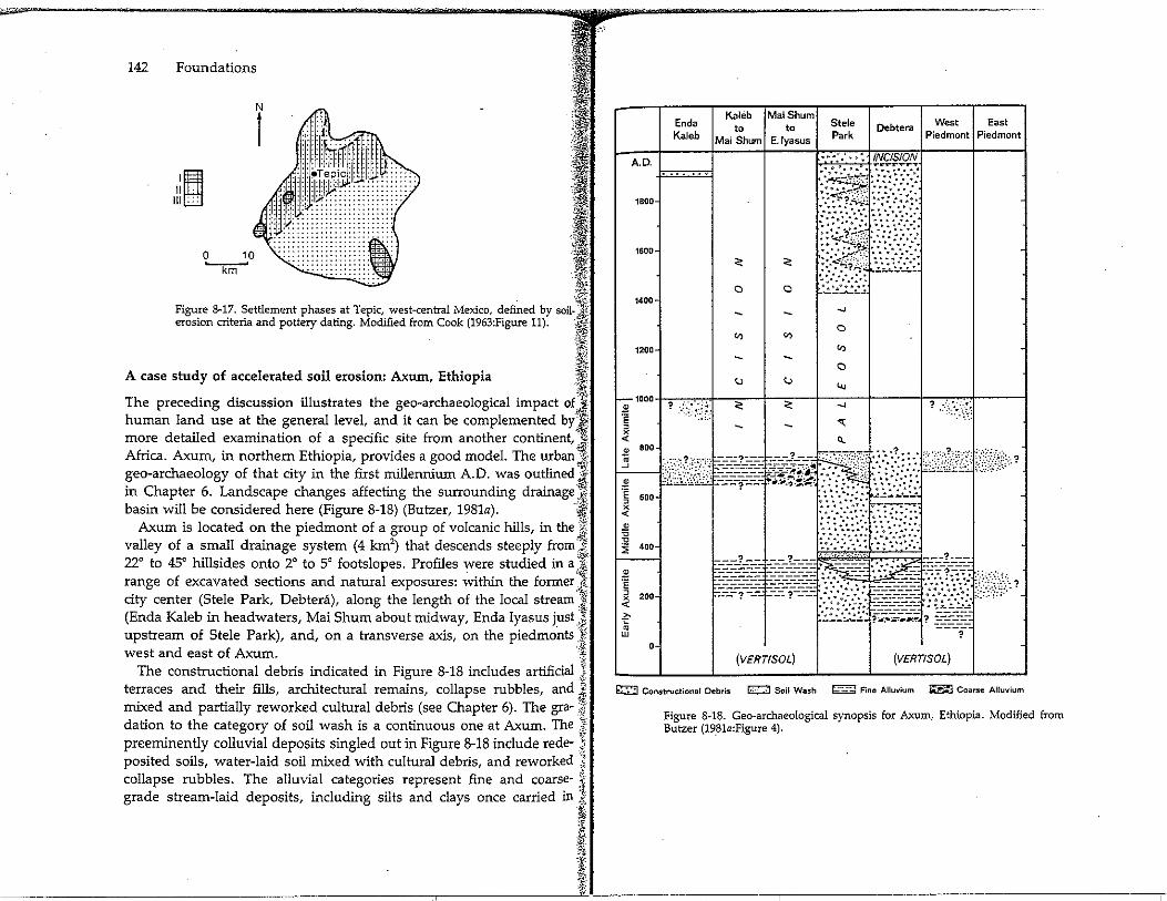
1977a) (Figure 8-16). Around Tepic, in western Mexico, three episodes J of soil erosion have been identified and linked to phases of succes- If: sively expanded agricultural land use, the most recent of which was J historical (Cook, 1963) (Figure 8-17). The Tepic record is based on trun- } cated soil horizons, relative degrees of soil reconstitution, and multiple f cut-and-fill cycles that permit determination of local settlement concen- .;, trations. In northern Guatemala, lakes Sacnab, Yaxha, and Quexil re· ·rc;
cord intensifying agricultural land use through exponential increases in 'f: their contents of grass pollen, clay, organic matter, carbonates, and Z phosphates since about 3500 B.P., correlated with demographic expan- '' sion until about a millennium ago (Deevey et al., 1979; Harrison and Turner, 1978). These New World examples serve to show that intensive J
~ land use and landscape degradation were not limited to European ,. areas affected by plow agriculture. '$
~-i ;.y', ))~-,; )t -~:. ··-
.E E .,,i=
.s. 2: " 0 ::, I ;::
~ u > w ~ = ' ~ 0
~ ~
0 %
"' 0 u E w ~ 1--;;;
"' w 1--= 0 "' ,::ci;
.=! cg
e~ ~o c:ici
142 Foundations
I II II
Ill, ••
·'1~ i:· "' ·~ •·iii I ~i .1}1i. ·.'~ :Ii!i I. . " ~
;..i,;,,
·~;; ,;q
Figure 8-17. Settlement phases at Tepic, west•central Mexico, defi~ed by son.J erosion criteria and pottery dating. Modified from Cook (1963:Figure 11). ·:~
,f!ic -, A case study of accelerated soil erosion: Axum, Ethiopia i·
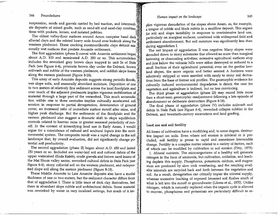
i~ The preceding discussion illustrates the geo-archaeological impact of :i human land use at the general level, and it can be complemented byl more detailed examination of a specific site from another continent,-.-~Africa. Axum, in northern Ethiopia, provides a good model. The urban J geo-archaeology of that city in the first millennium A.O. was outlined;~ in Chapter 6. Landscape changes affecting the surrounding drainage ;J basin will be considered here (Figure 8-18) (Butzer, 1981a). f
Axum is located on the piedmont of a group of volcanic hills, in the J valley of a small drainage system (4 km2
) that descends steeply from J 22° to 45° hillsides onto 2° to 5° footslopes. Profiles were studied in a }7
. '\rifl. range of excavated sections and natural exposures: within the former t} city center (Stele Park, Debtera), along the length of the local stream'} (Enda Kaleb in headwaters, Mai Shum about midway, Enda Iyasus just] upstream of Stele Park), and, on a transverse axis, on the piedmonts .·{ west and east of Axum. ·:g
The constructional debris indicated in Figure 8-18 includes artificial J terraces and their fills, architectural remains, collapse rubbles, and 1 mixed and partially reworked cultural debris (see Chapter 6). The gra- .?1 dation to the category of soil wash is a continuous one at Axum. The J preeminently colluvial deposits singled out in Figure 8-18 include rede- q posited soils, water-laid soil mixed with cultural debris, and reworked '!J.
collapse rubbles. The alluvial categories represent fine and coarse- f grade stream-laid deposits, including silts and clays once carried in }
't:i { ·!J· ::~ 1¥ i· 'L
A.O.
1800
1600·
1400·
1200
-1000
i , X <(
* 800
J
2 ·;; 600 ,
X <(
-" ~ ,a
400
" ll ·;; ,
200 X <(
~ • w O·
Enda Kaleb
Kaleb Mai Shum to to
Mai Shum E. Jyasus
Q Q
"'
Stele Park
Debtera
•••::.,: INCISION • ... ..... ,,...,..T" ...
'..!.:::..:...:~.; __,
Q
"'
__,
..
West East Piedmont Piedmont
-
.
~~~'!!ct~1lW£l\i~~~'"'···'·
[~i~3*if iz,if ti½;cww,. ?
(VERT/SOL) (VERT/SOL)
~ Constructional Debris G::j Soil Wash r..;--~;i Fine Alluvium ~ Coarse Alluvium
Figure 8-18. Geo-archaeological synopsis for Axum, Ethiopia. Modified from Butzer (19_81a:Figure 4).
-· 144 Foundations 'ti suspensio~, sand~ and gravels carried by bed traction, and intermedi-.,".i·;·\ ate deposits of In1Xed grade, such as sand-silt and sand-clay combina-1\ lions with pockets, lenses, and isolated pebbles. f~
The oldest valley-floor surfaces around Axum comprise basal darki: alluvial clays and the related heavy soils found over bedrock along th~., ... western piedmont. These cracking montrnorillonitic clays delimit sea-,J sonally wet surfaces that predate Axumite settlement. \:rj
The first aggradation (phase I) coeval with Axumite settlement began,'·'·· about A.D. 100 and terminated A.D. 350 or so. This accumulation ,llt includes the reworked gray brown clays trapped in unit 2e of Stele '1 Park (see Figure 6-4), prismatic brown clay under the Debtera, brown '.!fj soilwash and rubble of the western piedmont, and reddish slope loams :'i,l along the eastern piedmont (Figure 8-18). C:~
This array of early Axumite deposits suggests strong periodic floods:\t" wet slope soils, and seasonally abundant moisture. Deposition of one ';Ir to two meters of relatively fine sediment across the local floodplain and Ji. over much of the adjacent piedmonts implies vigorous mobilization of Ji.' material through a large part of the watershed. This much accumula<f tion within one to three centuries implies culturally accelerated soil )} erosion in response to partial devegetation, deterioration of ground ·i cover, an increased ratio of immediate surface runoff after rains, and _ _.j. higher peak discharge. But the sediments of the floodplain and the ·::j; eastern piedmont also suggest a dramatic shift in slope equilibrium ~j'.' controls related to heavier rains or greater seasonal periodicity of run- j, off. In the context of intensifying land use in Early Axum, I would Ji) argue for a coincidence of cultural and acultural inputs into the envi- .ij" ronmental system. The composite result was a rapid change in the soil }i'! landscape that, by overall evaluation, did not significantly change po- I tential soil productivity. .it
The second aggradation (phase II) began about A.D. 650 and lasted §1 150 years or so. Included are water-laid soil and cultural debris of the r:,
-~·· upper watershed (Enda Kaleb), crude gravels. and brown sand loams of ;J the Mai Shum valley sector, reworked cultural debris in Stele Park (see 1lf Figure 6--4), stony colluvial soil on the western piedmont, and redepos- if ited slope soil along the eastern piedmont (Figure 8-18). ''.Jl
These Middle Axumite to Late Axumite deposits also have a modal l thickness of one or two meters, but the sediment character differs from "ti that of aggradation I. There is little trace of dark clay derivatives, but $. there is abundant slope rubble and architectural debris. Some material Ji was reworked by water in very localized settings, but much of it im· f
~ i'! "lY ·l!: :i I ~~:
Human impact on the landscape 145
plies vigorous denudation of the slopes above Axum, as'. for example, a tongue of cobble and block rubble in a mudflow deposit. This argues for soil and slope instability in response to overintensive land use,
articularly on marginal surfaces, combined with widespread field and ~ettlement abandonment. But soil moisture was significantly less than during aggradation I.
The net impact of aggradation II was negative: Many slopes were denuded down to stony substrates that allowed no more than marginal browsing or charcoaling activities; extensive agricultural surfaces atop and just below the volcanic hills were either destroyed or reduced to a small fraction of their agricultural potential; even on the gentler lowland slopes, the more organic and better aerated A horiz~ns ~ere selectively stripped or were mantled with sandy to stony sml denvatives from the base of former soil profiles. The geomorphic evidence for culturally induced environmental degradation is direct; the case for vegetation and agriculture is indirect, but no less convincing:
The third phase of aggradation (phase III) may record little more than a short-term geomorphic readjustment following a late episode of abandonment or deliberate desJruction (Figure 8-18).
The final phase of aggradation (phase IV) includes soilwash and debris in Stele Park (see Figure 6-4), reworked collapse rubbles rn the Debtera, and twentieth-century excavations and land grading.
Land. use and soil fertility
All forms of cultivation have a modifying and, to some degree, destructive impact on soils. Even where soil erosion is m~irnal_ or is ~recluded, soil fertility is prone to rapid and sometimes irreversible change. Fertility is a complex matter related to a variety of factors, each of which can be modified by cultivation or soil erosion (Pitty, 1979):
1. Mineral nutrients. The microorganisms of a healthy soil generate nitrogen in the form of ammonia, but cultivation, oxidation, and leaching deplete this supply. Phosphorus, potassium, calcium, and magnesium are produced by slow rock weathering, and the resulting available minerals are recycled back and forth between the vegetation and soil. As a result, devegetation can critically impair the mineral supply, whereas excessive leaching of exposed loosened soil flushes much of what is left into the runoff or groundwater (Likens et al., 1970). Unlike nitrogen, which is naturally replaced when the organic cycle is allowed to recover, phosphorus and potassium are particularly difficult to re-
146 Foundations
plenish, so that long-term deficits affect all kinds of vegetative growth,~. even dominant woodland ·forms. Jj
2. Organic matter and microorganisms. Properly decomposed nonacidic)/!i humus is essential to soil productivity, because it combines with clay 1! particles to form molecular aggregates with high valences that link up '.'."ij with and stabilize ammonia, potassium, phosphorus, calcium, and j magnesium. This beneficial "mild" humus is produced by the teeming ~ soil microorganisms, of which the better types are very sensitive to ·j; dehydration, waterlogging, and acidification. Cultivation reduces mi-·f
,;;..,.
croorganic activity, so that crude organic matter is not properly in-J~ gested, remaining in raw or acidic form. The reduced pH inhibits the J; microorganisms even further, and the base nutrients become mobile. :.f As they are progressively lost from the molecular aggregates and re-Jlj placed by hydrogen ions, acidity increases, and nutrients are washed Ji out or leached. The organic cycle can be restored by allowing natural §
. -~;t vegetation or regenerate over 20 years or more, but if the pH has .J dropped below 5 or so, the damage may be irreversible without appli- ;ti: cation of artificial fertilizer (e.g., lime to raise pH, and mineral bases to·'.'¾ allow the growth of plant types that generate nonacidic organic debris).}~ This organic cycle is fundamental not only to retard leaching but also to ;t ensure good permeability, water retention, and aeration-properties J implied in the concept of soil structure. These properties again affect Ji the organic cycle by ensuring a beneficial microclimate in the soil: not ,f. too dry and not too wet, with adequate aeration, thus allowing the :i microorganisms to thrive and respire carbon dioxide freely. . J~
3. Texture. The basic mineral matrix of the soil is also important, l particularly the quantity of clay minerals and the types of clays repre- .~. sented. Clays play two different roles. First, their presence is essential } for water retention and for an inherent dynamism whereby soil aggre- J, gates expand when wet (retarding excessive percolation and mechani- J cal leaching) and shrink when dry (providing aeration and access for J' subsequent infiltration by rainwater). Depending on how expandable J the clay type is (montrnorillonite high, illite intermediate, kaolinite very '.:;' low), less than 5% to 10% clay is inadequate for proper moisture reten- 'i tion, whereas more than 25% to 50% is excessive, leading to temporary -'?
or permanent waterlogging and poor aeration. Organic matter enhances the beneficial properties of clays by an order of magnitude, so ,. that excessive cultivation of clayey soils favors compaction, poor aera~ ) tion, and temporary waterlogging, reducing vegetative growth and in- ') hibiting microorganic activity. Clays have different valences with }
~% •"f. ':f.i ,'* ,. ·.~; :Ji
1:
Human impact on the landscape 147
which to hold nutrient bases (kaolinite low, illite high, montrnorillonite an order of magnitude higher than kaolinite), a capacity that is also greatly enhanced .in clay-humus molecular aggregates. This number of available electrical links for mineral bases is called the exchange capacity; together with the pH, which gives an index of the proportion of available electrical charges that actually hold on to bases, the exchange capacity provides an objective measure of potential fertility. Altogether, selective erosion of clays by sheetwash, let alone destruction of the clayey segmenis of the soil profile by rill erosion of gullying, will have a catastrophic impact on soil fertility. Because clays form slowly over many millennia, severe soil erosion imposes essentially permanent restrictions on potential productivity.
Altogether, soil fertility is a fragile commodity, and many advanced forms of deterioration are almost irreversible, .except with the application of special technology, at great cost of labor and capital investment, seldom available to subsistence economies. Several types of land use in prehistorical times can be expected to have had different effects on sustained fertility and productivity; discussions of these effects have been provided by Clarke (1976), Kirch (1978), and especially Denevan (1978).
The small, scattered, low-density populations of Neolithic Europe appear to have employed the long fallow system, cultivating small dispersed plots for a year or two, then allowing forest regeneration over 20 years or more. This method is generally not precarious: Erosive losses are negligible, soil nutrients and moisture are preserved, and regeneration is rapid. Larger populations can be supported by interposing short fallow periods of 4 to 20 years, generally sufficient to improve soil aeration and restore organic matter and nitrogen, thereby maintaining a reasonable degree of fertility and productivity (Greenland and Nye, 1959). But the simple probabilities of dehydration and sheet erosion are increased, and the typically denser spacing of fields tends to favor more disturbance and overall deterioration.
Bush or grass fallow periods of or\ly one or three years require increased labor input, because weeds and pests -become endemic, and maintenance of aeration and soil structure necessitates elaborate hoeing or plowing to loosen and mix the soil. Fertilization techniques probably were not understood by most prehistorical farmers, as suggested by a lack of any documentation from pharaonic Egypt (Butzer, 1976c:89-90). Consequently, declining crop yields were inevitable and progressive soil loss probable. When such plots were eventually abandoned, the leached
if ~ ~ 148 Foundations ,,,,, }~;
and often more acidic soils were inadequate for nutrient-demanding '1: trees, favoring a secondary vegetation dominated by different species; in ::::r_ cool wet environments this led to the expansion of acidic heaths or peat Ji' bogs. Forest recovery may have been permanently impeded by livestock ,~ grazing and deliberate burning, with animal trampling and continuing j rainsplash erosion inhibiting soil recovery and accelerating soil erosion. ,;,{ Such increasingly degraded vegetation provides fewer plant types suit-':} able for human consumption and, in competition with domesticated ;;: stock, can sustain fewer species of large game animals. . ·1~~
Soil erosion and depletion vary greatly according to the type of soil :;< preparation. Hoe cultivation of small seeding areas breaks up only a J fraction of the sod, and modem experiments have shown that such a J!i no-tillage technique can reduce soil erosion to 1 % or 2% cif that typical J, for plowed fields, under otherwise identical conditions, with runoff cut , to perhaps half (Phillips et al., 1980). Spot hoeing provides lower short- [/'. term yields but allows more sustained productivity, not only as a con- '; sequence of little or no soil loss but also because soil moisture is re- -f tained, seasonal dehydration is less probable, and soil 'temperatures are tr lower, with correspondingly less oxidation of organic matter, while soil _{ structure and microorganic activity are maintained. ·t
By contrast, plow agriculture produces higher yields per unit area in the short term and makes subsoil layers accessible to plants by deep plowing. But plowing can readily become an ecological disaster, and even under optimal circumstances erosion and soil depletion are almost unavoidable. Long-term yields can be sustained only by largescale application of fertilizer- an almost impossible task for subsistence farmers. A third type of agricultural preparation is exemplified in highproductivity gardens adjacent to settlements. Such horticulture is normally predicated on liberal applications of animal and human manure. Good microorganic activity is maintained, and high yields are guaranteed indefinitely. Provided the climate is warm enough and irrigation is applied as necessary, two or three harvests per plot per year may be possible. le
Agricultural strategies evidently have invoh<ed some degree of awareness of short-term arid long-term maximization alternatives. Gearing and preparing the ground on a new plot may involve less work than combating secondary vegetation and pests while maintaining the soil productivity of old plots. The availabilities and effective costs of technology, labor, and new land were and remain major considerations in such decisions. Accordingly, pervasive if subtle modifications are imposed on the landscape.
Human impact on the landscape 149
Careful dating of British Jake cores has provided a first approximation for the durations of periods of woodland clearance, cultivation, and regeneration. Small-scale local disturbances of the sort implied by long fallow or short fallow appear to have been too brief to be identified by current methods. Episodes of farming that lasted between 100 and 1,000 'years have been documented from various British sites !Edwards, 1979; Turner, 1979). These represent the cumulative record of innumerable local clearances in a pollen source area with extensive and often sustained human activity-probably documenting situations with
grass or bush fallow.
Geo-archaeological landscape features
The preceding sections have focused on the significance of human activities for soils, a factor generally underappreciated by archaeologists. It is now appropriate to consider the record of creative human intervention in the landscape (see Chapter 3). Major features of this type can be outlined as follows: .
1. Plow (Ap) horizons in areas formerly cultivated but not currently cultivated (Limbrey, 1975:331-2) or buried under the spoil of old ditches earthworks, or mounds.
2. S~oils from ditches, pits, and earthworks, as well as primary mounds, that bury older surfaces to create paleosols (Dimbleby and Speight, 1969). Loose erodible soil is only partly washed. back into artificial depressions, leaving irregularities plainly visible m surface
morphology. 3. Infillings of ditches, pits, palisades (postholes), and wells oft~n
are visible at the surface or from the air because of their greater moisture retention and richer vegetation, even where compaction has not created a negative imprint. The sediment infillings usually include complex stratified lenses due to textural sorting, mixing, reversal of soil profiles, and multiple humic horizons (Limbrey, 1975:292-9, 304-9; Evans, 1978:112-21; Vermeersch and Walter, 1978) (Figure 8-19). Such surface and subsurface patterns are critical for indentification of archaeological configurations, and at the same time they provide testimony of land-use activities. Gabriel (1979) desmbe_d a vanety of ~rchaeological features from the Sahara that are easily confused with "natural" geomorphic features: subterranean storage pits, smooth rock concavities ground out by milling stones, multiple grooves in rock faces used to sharpen tools, and various geometric stone arrangements representing the remains of occupation structures.
150 Foundations
Loess
0 so om
Figu:e 8-19. P~lisade pseudomorph fill, ca. 5250 B.P., at Thieusies, near Mons, Belgium. Modified from Vermeersch and Walter (1978:Figure 3).
4. Prehistorical roadways and trails, even when not traveled by wheeled vehicles and animals, tend to form conspicuous negative imprints on the landscape as a result of accelerated runoff, rilling, and soil erosion. Such depressed linear features, as well as convex, rockpaved forms and rock-cut stairways, also affect vegetation patterns through moisture retention different from that of adjacent fields. Numerous examples can be cited from Italy, the borderlands of the Roman Empire, the Inca highlands of Peru, and the San Juan Basin of the American Southwest.
5. Terraced fields are conspicuous in many irregular and mountainous landscapes of most continents, ranging from Britain (Bowen, 1961; Fowler and Evans, 1967) to Southeast Asia (Spencer and Hale, 1961; Wheatley, 1965) and Latin America (Donkin, 1979). The idea of terracing is to build low rock walls along selected contours or across the lower slope of a field. Material is then excavated from below each such wall to be filled in above the next lower one, creating a stepped surface in which each field floor has perhaps half the original slope gradient. These terraces ( called lynchets in Britain) retard runoff and soil erosion (Figure 8-20). Even when partly washed out by severe storms or after
Human impact on the landscape 151
Retaining
Excavated Built Soi/ wall
0 1
--. --=~·-s-•-.. -.r~
Built terrace base
m
Figure 8-20. Hillside field terrace construction in Mediterranean Basin.
abandonment, such terraces remain conspicuous landscape features over rp.any millennia.
6. Irrigation furrows, ditches, canals, and control gates are prominent parts of the archaeological record in many semiarid and desert settings. Their gross configurations have often been mapped (e.g., from aerial. photos) during the course of ground surveys {Adams and Nissen, 1972), but detailed study and reconstruction (Achenbach, 1976; Farrington and Park, 1978) are still the exception rather than the rule. In fact, I was able to identify a small irrigation network during the first day of a visit to a major archaeological project (unnamed here) that had operated for a decade without even recognizing the sand-filled canals.
7. Middens are heaps of archaeological debris, commonly including organic wastes, shell, bone, or ash. They range in size from a few square meters to prominent landscape features 50 to 100 m long and 15 m or so high. Many large middens also served as occupation sites, but the majority of smaller middens were special-processing loci or the refuse dumps of larger settlements. Particularly striking are the coastal middens of some areas, composed largely of molluscan shells or shell residues (Evans, 1978:126-9), with interstitial eolian sand,. soilwash, and ash. Another case in point is provided by the so-called snail mounds (escargotieres) of Algeria and Tunisia, composed of ash, bone, and countless land snails (Hassan and Lubell, 1975).
8. Burials and burial mounds of prehistorical cemeteries also contribute to archaeological topographies, although simple graves tend to be refilled in much the same order as they were opened and can easily be overlooked. Rock piles (tumuli or c·airns), megalithic blocks, and earth mounds are far more conspicuous, such as the Bronze Age "barrows" of England, consisting of earth-covered stone-lined burial tunnels
152 Foundations
(Evans, 1975:116-17, 132-3). Even more complex is the stratigraphy of the multiple Indian budal mounds built in the central and eastern United States (Schroedl, 1978) (Figure 8-21). Burials may be identified (even when bone has been decomposed) through detailed phosphate analyses (Proudfoot, 1976) or by stain silhouettes identified in plan section (Biek, 1970).
9. Prehistorical flint mines were important in Britain and Belgium (De Lael, 1972; Evans, 1975:124-8; Bosch, 1979; Shepherd, 1980) and elsewhere. Most striking are large pits cut through soft overburden down to flint-bearing limestones, sometimes involving deep shafts that honeycomb the bedrock as much as 20 m below the smface. Such mines and their associated spoil heaps remain visible even after partial refilling (Figure 8-22). Bronze Age and Iron Age mines for critical ores tend to be even more elaborate, and the related slag from furnaces can be prominent in the geo-archaeological record.
10. Artificial soils are not unusual in some marginal agricultural environments in Europe, particularly in reclaimed fens, bogs, and tidal marshes along shorelines and poorly drained floodplains. Complex examples include drainage ditches, protective dikes, wood-plank roadways and revetments, and raised agricultural plots, first reinforced by ditch spoil and then veneered with imported mineral soil and organic fertilizers (Sticher van Bath, 1963; Limbrey, 1975:335-41). Underlying peat moss may first be cut away for use as fuel. This technique, in its more elaborate forms, continued in use through medieval and modern times as more and more marshland was settled. Artificiaily raised fields, intended to allow cultivation of poorly drained areas, are also widespread in tropical environments (Denevan and Turner, 1974; Turner and Harrison, 1981). ·
The various features outlined here provide an overview of the many geo-archaeological indicators that record human activities in the land· scape, thus documenting the spatial patterns of settlement. Such features are relatively obvious, both morphologicaily and analyticaily, and they should serve to direct attention to the less visible but more univer· sal records of general landscape modification and degradation documented in soil profiles and floodplain geomorphology. One major obsta· cle in regard to recognition of prehistorical three-dimensional land-use patterns is the increasingly heavy hand of industrial societies exerted on almost every facet of the landscape. A second obstacle is more easily remedied but no less urgent: the widespread disregard of land-use crite· ria in archaeological research design and methodological discussion.
154 Foundations '.~i t~ ,I
,-----------ii----------, '"
I Chalky limestone bedrock
0 2 ---;;,
Buried soil
Chert bands
Quarry pit fill
' / .......... _____ .,,.
L3 m
' ~ ~ I j "1 ~il:).
i ,~-Figure 8-22. Prehistorical chert and indurated shale quarries in Britain.· Modi- "{~: fied from Evans (1975:Figures 54 and 56). .,f.i;j,
·Ji Landscape productivity and degradation Yi
.?i~ 'I_he human capability to modify the environment implies that the rela- ;'.f tionship between people and their environment is a reciprocal one. :.'ff Consequently, in order to keep the subsistence-settlement system in a ,:fil stable relationship with the environment, resources must not be over- ·J exploited. Land use denotes more than an adaptive strategy, because it ~:: implies the impact of people on a landscape. The geo-archaeological Jt; strategy developed here allows comprehensive assessment of the cu- fJ:/ mulative direct and indirect impacts of human activities on soils and Jf: sedimentation in particular and on ecosystems in general. Such an Ji:: approach is critical to proper spatial and temporal perspectives on agri- i1 cultural societies and pastoral groups. 'iH
The spatial perspective focuses on understanding the distribution If and patterning of activities within a complex mesoen~ronment. Such ' •. ·,_· .. _''..;_. activities must, insofar as is possible, be defined in real inductive _.,_ terms, such as by implementation of site catchment analysis (Vita-Finzi '1~·
and Higgs, 1970; Higgs and Vita-Finzi, 1972; Higgs, 1975:223-4). Catch- ·; ments can be profitably examined and reconstructed by teams of quali- :•, fied researchers willing and able to employ new recovery strategies }\ beyond the immediate confines of an excavation. The geo-archaeolo- ~ gist, like the modern land-use planner (Davidson, 1980a; Morgan, ;_,',',' 1979), can devise terrain maps representative of the period of occupation that incorporate data on relief and surface roughness, texture of surficial sedimilents, and any indicators of intervention in the contem- ~ .. ·.:'. poraneous so· mantle and hydrological processes. Such criteria have · significance both for predicting vegetation mosaics, in conjunction with t ,,,
:,x
I :. "' !:
Human impact on the landscape 155
biological evidence, and for assessing soil moisture, productivity, and erod.ibility (see Chapter 13). Along such lines, a group of researchers can then generate local models for primary productivity, biomass, and carrying capacity of macroconsumers, as well as the potential yields of cultivated versus gathered vegetable foods and domesticated versus wild animal resources. When these are complemented by appropriate archaeological surveys, a realistic spatial evaluation of prehistorical human activities is at least theoretically possible. Given the realities of research funding and the limited number of qualified experts available, it seems unlikely that such spatial resolution can be achieved in the near future. Perhaps the best we can hope for at the moment are compromise· efforts, such as the empirical resource distribution and procurement analyses of Kirkby (1973), Flannery (1976:Chapter 4), and Harrison and Turner (1978).
In regard to temporal perspectives, the geo-archaeological record complements excavation and settlement surveys through its inherent sensitivity to stress in the ecological system. Intact natural ecosystems support complex food cl).ains in which population sizes are regulated so as to maintain similar patterns of energy distribution from one year to the next. In degraded ecosystems, on the other hand, annual productivity fluctuates more. strongly, because larger numbers of individuals and fewer different species allow little internal regulation, permitting strong fluctuations in consumer populations (Woodwell, 1970; Odum, 1971). This biological appreciation carries insights for soil landscapes, on the one hand, and human adaptive systems, on the other. Deforestation, grazing, and cultivation create fragile soilscapes that are susceptible to rainsplash, accelerated runoff, reduced infiltration and aeration, periodic dehydration,· erosion, and declining fertility. High human population densities are possible,· far exceeding those in foraging societies in which people are but a small segment of the consumer
· community, But agricultural and livestock productivity will fluctuate far more dramatically than that for game and vegetable foods in an intact ecosystem and will eventually decline without massive inputs of technology, labor, and capital. Agricultural ecosystems consequently represent short-term maximization strategies, unless carefully tailored through generations of trial and error to approximate a homeostatic equilibrium. The geo-archaeological record of soil erosion and related cut-and-fill cycles demonstrates that homeostatic equilibrium has rarely been maintained over the long run.
In the Dartmoor region of southwestern England, palynological
156 Foundations I studies and soil-stratigraphic work have documented progressive, but:" initially localized, disturbance. Late Bronze Age deforestation and _j farming then led to widespread soil leaching, acidification, and peat .1'/ bog expansion that were completed during the Iron Age and thus ff destroyed most of Dartmoor's productivity (Simmons and Proudfoot, I' 1969). .@;:
In Middle Axumite times, the environment of northern Ethiopia prob- fj; ably had been stripped of most of its export resources, such as ivory, I.,, .. ;· incense, and civet musk. When the disruption of international trade ::- i during the seventh century A.O. reduced revenues, Axum lost the k wherewithal to control the resources of its border provinces; as a re- :~1-
~..;;.-suit, intensified land pressure at home led to rapid environmental deg- Jr radatipn and essentially permanent destruction of much of Axum's .f agricultural potential (Butzer, 1981a). Similar examples can be cited ;Ji. from contemporary industrial societies, such as the United States, _\j where estimated soil losses over half of the country are double the }t amount considered compatible with permanent agriculture (Pimentel et J/i al., 1976; Brink et al., 1977). Such modern disturbance has corollary }) implications for the conservation of archaeological sites: Mechanized !: agriculture destroys sites, and, indirectly, the high peak discharges of ,11'. degraded ecosystems favor site erosion or deep burial in the wake of i'f rapid floodplain aggradation. 1,,
Geo-archaeological investigation of landscape context can, in con- ~ junction with archaeological survey, elucidate the subtle reciprocal re· -'~ sponses of settlement systems and ecosystems through time; it.can also -1i identify the drastic and sometimes irreversible modifications of re- •i, gional ecosystems. The interrelated vegetational succesSions, the shifts ~~l in hydrological regimes, and the modifications in the delicate balance fr between soil formation and soil erosion are of more than esoteric land~ :~? scape interest. They reflect significant changes in automorphic produc- j tivity, with direct consequences for both animals and people. Long- -, term adaptive success evidently is predicated on such dynamic envi- :'.m ronmental variables. j
CHAPTER 9
Archaeometry: prospecting, provenance, dating
Scope and purpose of archaeometry
The term archaeometry has been in common use since 1958, when the first volume of the journal Archaeometry was published by the_ Research Laboratory for Archaeology at Oxford. The contents of this Journal were and have remained technical expositions of physical and chemical methods applicable to dating and material~ identifi~afon in archaeol-
Other periodicals publishing substantial contributions to archae~!;'~try include the Journal of Archaeological Science (since 1974) and Revue d'Archeometrie (since 1977) (Beck, 1980). A broader array of relevant techniques and applications has been presented in the Brothwell and Higgs compendium Science in Archaeology (1970, first editi~n 1963) and b Brill (1971). Despite some overlap with geo-archaeo!ogical and b10-a:chaeological research, the input of physical and chermcal methodologies to archaeology continues to be distinctive.' These efforts are _here labeled as archaeometry, and three major applications are recogruzed: (a) subsoil prospecting, (b) materials identification and provenance, and (c) "absolute" or chronometric dating. _ _
The great majority of archaeometric techniques require expensive equipment ranging in price from· several :housand d~llars to over a million dollars. The work tends to involve tune-consuming procedu'.es or highly repetitive manipulations that follow a well-defined routine and can be readily replicated. Many of the techniques can be learned and then applied, with reproducible results, in a comparatively short
time. h In these several ways archaeometry tends to differ from geo-arc ae-
ology and bio-archaeology' in whi~ equipment n~eds are ~odest, ~ut competent application requires long years of expenence a~d innovative adaptation of basic procedures to specific projects. Heavily dependent on observational methods and the comparative approach, geo-archaeological data and interpretations often are disturbingly difficult to repli-
157