Embed Size (px)
Citation preview

STUDIA HERCYNIA XIX/1–2, S. 262–281
archaeological Survey in the zarabag Micro oasis (South uzbekistan), Preliminary report on the Season 2015
Anna Augustinová – Ladislav Stančo – Shapulat Shaydullaev – Michal Mrva
aBStraCtThe present article summarizes the methods and results of archaeological research initiated in the autumn 2015 in the Zarabag Oasis (Sherabad District, South Uzbekistan). The main goal of the research was to obtain basic data on the settlement dynamics in the given area. The fieldwork methods comprised both extensive and intensive surface survey. The extensive part of the survey focused on detecting visible structures and morphological features in the landscape, detecting pottery scatters and other finds and mapping water sources. As an intensive part of the project we carried out a systematic surface survey at a selected field in the oasis. These works resulted in the detection of 20 sites, six water springs, and 16 pits belonging to karez systems. According to our surveys, the Zarabag Oasis has been continuously settled by a mixed agricultural and nomadic population since at least the High Medieval Period, sporadic earlier occupation comprises not only the Early Medieval and the Late Antique Periods, but also the Late Bronze and the Early Iron Ages.
kEywordSBactria; Tokharistan; surface survey; settlement dynamics; oasis; water sources; karez; Sapalli; Yaz; Middle Ages; Central Asia.
introduCtion
The steppe belt of the Kugitang piedmonts had been subject to several archaeological surveys. As a rule, previous researchers did not focus on a micro ‑region in detail, but typically either conducted large ‑scale extensive surveys of this specific landscape unit as a whole (Rtveladze – Khakimov 1973, 16–17; Rtveladze 1974, 66–67; Bobokhojaev et al. 1990), or paid their attention selectively to the closest vicinity of a site, excavated during long ‑term projects (Mkrtychev et al. 2005; Kaniuth 2009). Some of the published reports testify rather to randomly placed investiga‑tion targets (Dvurechenskaya et al. 2014). Recently, a Czech ‑Uzbekistani archaeological expe‑dition initiated a complex archaeological prospection project, focused initially on the lowlands of the Sherabad District (the so called Sherabad Oasis), but continuing in the piedmonts of the same district in the next step. Among the well ‑watered micro ‑oases of the largest of the piedmont valleys – the Pashkhurt Valley – some were quite well surveyed by archaeologists, especially their central settlements (Pashkhurt itself, Karabag, Maydan),1 but the other oases in the valley remained surprisingly unexplored. The most striking example is Zarabag village and its oasis.
In the autumn of 2015 an archaeological research was conducted in the small oasis, where the present ‑day village of Zarabag is situated, and in its nearest surroundings. At the same time, another part of the Czech ‑Uzbekistani ‑French team excavated the Yaz I site of Burgut
1 Arshavskaya (et al. 1982) knows only one archaeological site of the Medieval Period in Maydan (Maydan Kurgan), one in Pashkhurt (Dabil Kurgan) and three in Karabag (Gilampushtepa, Mazaristantepa and Kurgantepa).
263ANNA AUgUSTINOVÁ – LADISLAV STANČO – SHAPULAT SHAYDULLAEV – MICHAL MRVA
Kurgan (Stančo et al. forthocoming in SH XX/2). The prospection activities were carried out by two students of the Institute of Archaeology of Charles University in Prague aided in the initial stages of the survey by Odiljon Khamidov from the Termez State University in Termez. Throughout our survey, we were accompanied by a local herder Rustam who greatly helped us to communicate with locals but who also drew our attention to numerous studied features and contexts. The research took three weeks at the turn of September and October 2015 and com‑prised of field work in the oasis and its nearest surroundings and documentation of the small finds.2 Most of the finds were dated according to the expert examination of Sh. Shaydullaev.
THE RESEARCHED AREA
The research area is situated in the western part of the Sherabad District of the Surkhandarya Province, South Uzbekistan, 6km to the north of the centre of the village of Pashkhurt. The village of Zarabag (meaning literally “Golden orchard” in Tajik) is located at E 66°44’ / N 37°45’, approximately 985m.a.s.l. There are two possible ways of access to the village. The main one goes from the Sherabad River Valley (Tashkent – Termez highway) in the direction to Pash‑khurt from which the road to Zarabag departs in Maydan. Zarabag is placed 6km north ‑west of this crossroads. The second – less frequented and in much worse condition – way runs straight from the north end of Pashkhurt (4km) via a dry riverbed. The border between Uz‑bekistan and Turkmenistan runs 15km to the west of the oasis along the ridge of Kugitang. In the spring season there are two rivers (Shalkan and Machayly) flowing through the Zarabag Oasis. During the rest of the year their riverbeds are dry. The village, however, is supplied by other water sources. Their mapping was also a part of this year’s exploration.
The archaeological potential of this area has been revealed by earlier surveys realized by the Czech ‑Uzbekistani Team of archaeologists (Stančo 2009; Danielisová et al. 2010; Stančo et al. 2014). The studied village of Zarabag is also mentioned in a recent article (Dvure‑chenskaya et al. 2014), which presents three spots in the area (indicated as GPS points), where the evidence (pottery) of historical settlements has been found.
A local legend says that the village of Zarabag was founded by a hunter from Pashkhurt after killing a tiger in the area of the later village at about the beginning of the 18th c. (Karmy‑sheva 1976, 129).3 Today, local people speak Tajik, and consider their dialect very old, which was, however, denied by other Tajiks (personal communication).
THE PRESENT STATE OF THE OASIS
For our archaeological interpretations, it is necessary to consider the traditional ways of life, including the water management and agriculture in this area, since these presumably differ very little from that of the studied (pre)historic societies. Various toponyms, which we learned from local people, represent important sources of information.
Unlike the surroundings, covered by foothills steppe, the oasis with its abundant water supply offers good conditions for horticulture and agriculture. The trees provide proper con‑ditions in hot summers and enable a fruit harvest every year (mainly apples, pomegranates, kaki – locally called khurma, nuts, grapes etc.). The gardens are used for the cultivation of vegetables (peppers, cucumbers, tomatoes, potatoes etc.). As in previous generations, the hous‑
2 The finds were deposited in the Termez Archaeological Museum at the end of the research season.3 Karmysheva states that her local informant Char’yarkul Baltaev told her the story in 1961 and calculated the
foundation date using the counting of generations of his ancestors known to him (Karmysheva 1976, 129–130).

264 STUDIA HERCYNIA XIX/1–2
es are made of mudbricks. The plots of land used prevalently as gardens are divided by walls made of unfired bricks and pakhsa blocks and plastered by lime. Because of the inhospitable conditions of the surrounding steppe, functional water management is necessary for local well ‑being. The oasis is interlaced with water canals that provide water for all inhabitants. Water is held in reservoirs in several public places and every day in the late afternoon when the sun is no longer so strong, they open a dam for a few hours to irrigate the fields and gardens. Some plots are not water soaked, some others are not dried up and thanks to the reservoirs and canals the water can be supplied equally.
MEtHodS and goalS of rESEarCH
The aim of the research was to recognize and to document the evidence of historical settle‑ments in the Zarabag Oasis and its closest surroundings. We tried to sample the whole oasis in an equal intensity. It was, however, not possible to cover it completely due to time constraints and therefore the work will continue the next season.
The important points (morphological features in the landscape, concentrations of finds etc.) were located by GPS Garmin eTrex, described and photographically documented.4 Af‑terwards the spatial data were processed by QGis and the movable finds were documented by drawings and photographs.
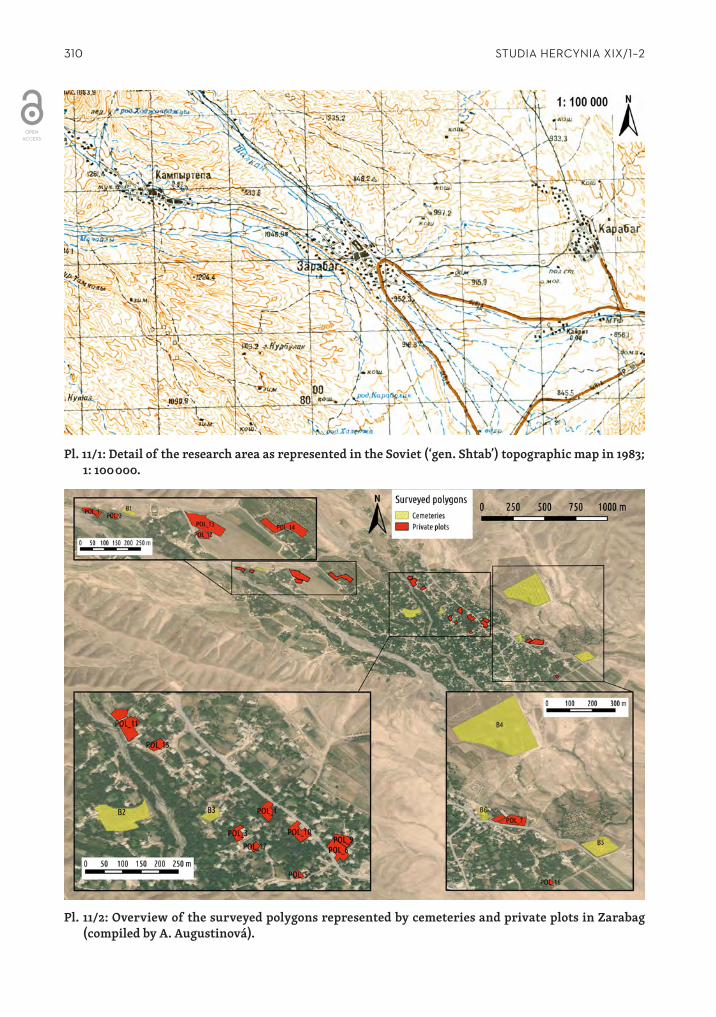
The only topographic map available for the studied area is the 1:100000 created by Soviet military in 1983 (Pl. 11/1). As the second crucial map source we used Google Earth imagery.
The research included two parts that were approached by two methods. The first part included an extensive surface survey inside the oasis, i.e. prospecting of selected plots of Zarabag inhabitants and of both disused and present ‑day cemeteries. We concentrated on the documentation and location of noticeable morphological features and on the documentation of datable finds. Besides this, we prospected the closest surrounding landscape and also doc‑umented and located the significant features and checked the places whose toponyms hinted at a possible connection with an earlier settlement.
The second part consisted of an intensive systematic field survey of a selected field in the oasis through which we strived to collect in this delimited area all anthropogenic material indicating any possible settlement during all historical periods. This method was based on the successful systematic field survey conducted earlier by P. Tušlová and her team in the lowlands of the Sherabad District (Tušlová 2011; Tušlová 2012).5 Their work took place in very different landscape conditions and was realized to a much greater extent. We adapted the survey methods to the conditions of the foothill steppe and concentrated it in a smaller area.
ExtEnSivE SurfaCE SurvEy in tHE zaraBag oaSiS
FIND SPOTS IN PRIVATE PLOTS
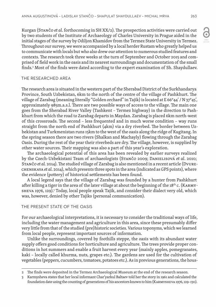
The first stage of the research was targeted prospecting based on the information provided by local inhabitants, who drew our attention to concentrations of pottery and other finds or to marked surface features. The researched area was divided into polygons, whose size
4 The photographs are by A. Augustinová unless otherwise stated.5 We would like to thank P. Tušlová for her help with the preparation of the survey and for all useful advice.
265ANNA AUgUSTINOVÁ – LADISLAV STANČO – SHAPULAT SHAYDULLAEV – MICHAL MRVA
Polygon Present use Coordinates
Quantity of finds (dated)
Type of finds Dating (quantity)
POL_1 garden 66.725989245 37.771942159 3 (2) pottery 19th c. (2)
POL_2 garden 66.727053327 37.771755494 3 (1) pottery, mor‑tar and pestle 12th–13th c. (2)
POL_3 garden 66.745201992 37.767603351 18 (15)
pottery (incl. a whole
vessel), metal, stone mortar
and pestle
Sapalli/Yaz (Late Bron‑ze Age/Early Iron Age)(1), Sapalli (Late Bron‑
ze Age) (2), Yaz I (Early Iron Age) (3), 6th–7th
c. (2), 12th c. (2), 16th c. (4), 18th c. (1), 18th/19th c.
(mountain area) (1)
POL_4 garden 66.746023502 37.768300222 19 (18)
pottery (incl. a whole
vessel), coin, stone
5th–8th c. (4), 12th c. (5), 16th c. (4), 19th c. (4)
POL_5 garden 66.74716034 37.766103661 1 (1) pottery 12th c. (1)
POL_6 garden 66.748128533 37.767205378 18 (16) pottery, human bones
5th–8th c. (1), 9th/10th c. (4), 10th/11th c. (11), 12th c.
(4), 18th/19th c. (3)POL_7
field 66.753392955 37.765495218 15 (9) pottery 5th–6th c. (2), 12th c.(2), 17th–18th c. (3), 19th c. (2)
POL_8 orchard 66.752283862 37.765591945 8 (1) pottery 12th c. (1)
POL_9 garden 66.748350905 37.767399084 40 (5) pottery, terra‑ cotta figurine 5th–6th c. (2), 10th c. (2)
POL_10 garden 66.747013237 37.767706029 30 (30) pottery, glass4th/5th c. (5), 10th c. (2), 12th c. (7), end of 13th c. (1), 16th c. (4), 18th c. (7)
POL_11 garden 66.741902623 37.770857541 3 (3) pottery 13th c. (1), 18th/19th c. (2)
POL_12 garden 66.731450139 37.77085511 9 (3)pottery (incl.
a whole ve‑ssel), coins
9th/beg. of 10th c. (2), 18th/19th (1).
POL_13 field 66.731677372 37.77109718 16 (3) pottery 5th–6th c. (3)
POL_14 orchard 66.735798335 37.771119727 4 (0) pottery
POL_15 garden 66.742428588 37.770107528 1 (1)pottery
(=whole vessel)
18th/19th c. (1)
POL_16 garden 66.754812934 37.762353849 1 (1)pottery
(=whole vessel)
18th/19th c. (1)
POL_17 garden 66.745691411 37.767108735 5 (2) pottery early 13th c. (1+1 – town import)
Tab. 1. The surveyed plots in Zarabag divided into polygons – location and basic facts.

266 STUDIA HERCYNIA XIX/1–2
and form correspond to those of the actual plots (gardens, fields, orchards etc.). Most of the finds were not documented in situ. They were unearthed during various earthworks in the plots and redeposited in secondary contexts. Altogether, 17 polygons were studied in this way (POL_1–17; Tab. 1; Pl. 11/2). Among these, 13 polygons represented gardens, while two polygons correspond with fields and two other ones with orchards. Out of the 194 pieces of pottery collected in total from this area, 110 fragments were possible to date. The remaining material was not chronologically relevant.
Most of the finds are represented by fragments of pottery, we have nevertheless also five whole or largely preserved vessels (POL_3, 4, 12, 13, and 16).
INVESTIgATION OF CEMETERIES
The other part of the extensive survey in the village Zarabag was the prospection of the disused and present cemeteries. This method has brought fruitful results in the surveys conducted by the Czech ‑Uzbekistani team in the last few years (Stančo et al. 2014, 31) in the nearby oasis of Karabag. In the Karabag cemeteries, the digging of graves intersected earlier settlement levels and brought to light artefacts deposited in them. Each of the Zarabag cemeteries was considered a single polygon as were also the surveyed private plots of land (Tab. 2; Pl. 11/2).
There are six cemeteries in Zarabag and all of them were the subject to our survey. One of them is used until the present day, in the remaining five burials had ceased to take place. The name of each cemetery is derived from the name of an imam buried there. Their graves represent the central points of the cemeteries where people come to pray and bring offerings.
The oldest burial site called Huyaobozi Vali (B1) is situated on the north ‑west margin of the oasis. Even though local people claim that the burying ceased 200 years ago,6 the central grave is still a lively place, where the Zarabag women light fires, say their prayers and bring offerings. Nobody seems to know today, who Huyaobozi Vali was and when exactly he lived. There are two types of graves in the remaining part of the burial ground. The first of them are graves with a stone circle on the surface (dm. 1–1.5m). The other type has a rectangular ground plan (1.55 × 2m), corresponding to modern ‑day Muslim graves. A small stone stele (0.4 × 0.25m) without any marks of stonework is raised beyond one of the graves. An engraved stele with a simple schematic figure is located in the north ‑west part of the cemetery (Pl. 11/11). Local people connect this stele with a legend about a woman who wailed at this place over the death of her small child until she turned into stone. The stele supposedly represents a mother hold‑ing her child in her arms.
The second oldest burial ground in the village called Kokiboy Ota (B2) lies in the northern half of the village near the right bank of the seasonal river Shalkan. A modern arch made of bricks with a concrete foundation spans over the main grave. According to the locals this cemetery has not been actively used for at least 200 years, just like Huyaobozi Vali (B1). Very little pottery or other finds have been found here, most of them belonging to the pre ‑modern period (18th–19th century) while the rest was impossible to date.
On the opposite bank of the seasonal river of Shalkan there is a nameless burial ground (B3). In its central part, there is a stone mound that resembles a central grave, but none of the local people was able to remember the name of the buried man. A similar feature is situated in the north ‑east of this area. Two graves are marked on the surface by a stone circle (dm. 1.2–1.5m). The burial ground is raised about 2 m above the surrounding terrain. The path crossing the
6 Take into consideration that the term “200 years” is just a formulation of a long period.

267ANNA AUgUSTINOVÁ – LADISLAV STANČO – SHAPULAT SHAYDULLAEV – MICHAL MRVA
Fig. 1: Pottery from Zarabag Oasis. Dating and find spots. 1. Sapalli culture (T1); 2. 4th c. AD (T1); 3. Unclear dating (K14); 4–5. 5th–6th c. AD (B6); 6–7. 6th–7th c. AD (POL_3); 8. 12th c. AD (B3); (drawing by M. Mrva).
268 STUDIA HERCYNIA XIX/1–2
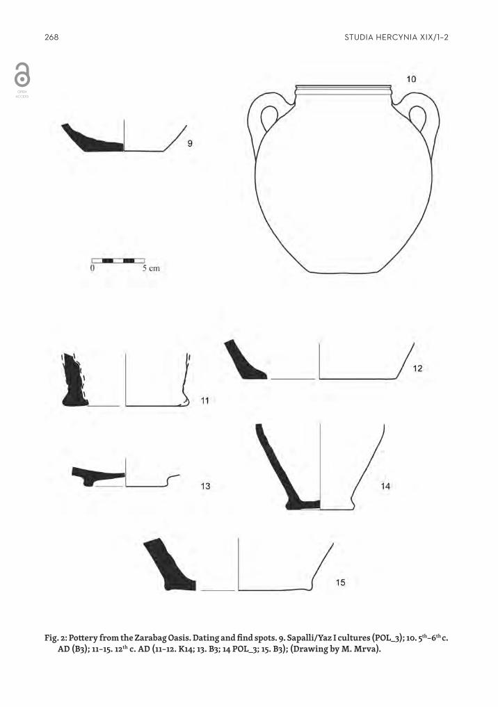
Fig. 2: Pottery from the Zarabag Oasis. Dating and find spots. 9. Sapalli/Yaz I cultures (POL_3); 10. 5th–6th c. AD (B3); 11–15. 12th c. AD (11–12. K14; 13. B3; 14 POL_3; 15. B3); (Drawing by M. Mrva).
269ANNA AUgUSTINOVÁ – LADISLAV STANČO – SHAPULAT SHAYDULLAEV – MICHAL MRVA
cemetery cuts through this raised terrain and reveals thick cultural levels containing ceramic fragments dated to the 4th century AD. Also a whole vessel dated to the 5th–6th century (Fig. 2:10) was discovered in this place. Other material found at the burial ground include fragments dated to the 12thcentury (Fig. 1:8, Fig. 2:15, 13) and a single Late Bronze Age (Sapalli) shard (Fig. 1:6).
No dating elements have been obtained in the other two cemeteries. The first of them in the eastern part of the village is still used as a cemetery today (B4). The second one called Khoja Rushnoy (B5) lies about 0.5km to the south ‑east of B4.
The last ‘cemetery’ is located near the old mosque (B6). Several grave pits were dug out here but never used for a burial afterwards. The excavated earth from these pits produced pottery dated to the Early Medieval Period (5th–6th century; Fig. 1:4, 5) and a unique clay seal representing a prancing ibex (Pl. 11/12) which can also be considered Medieval.
Name Coordinates Quantity (dated)
Type of finds Dating (quantity)
B1 Huyaobozi Vali 66.727887494 37.771865381 1 (0) pottery
B2 Kokiboy Ota 66.741550667 37.767572924 5 (1) pottery 18th–19th c. (1)
B3 no name 66.744283754 37.76789437 4 (3)pottery (incl.
a whole vessel)
Sapalli (Late Bronze Age), 5th–6th c. (1), 12th c.
B4 no name 66.75143335 37.769979453 1 (0) pottery
B5 Khoja Rushnoy 66.757123992 37.76438361 0 (0)
B6 near the mosque 66.751185581 37.765816748 15 (6) pottery, seal 5th/6th c.
Tab. 2. The surveyed cemeteries in Zarabag – location and basic facts.
WATER SOURCES IN ZARABAg OASIS
One of the goals that we have set, was the detection and mapping of water sources in the oasis and its surroundings, including monitoring of the water management of the present local population.
The streams of two intermittent rivers (Shalkan and Machayly) crossing the village in the NW ‑SE direction provide vast amounts of water during spring due to melting snow in the Kugitang Mountains. For the rest of the year, the rivers are minuscule or dry depending on the rainfall. The Machayly River situated further to the south was completely dry during the survey, while Shalkan River was reduced to a small stream. That is why the local population cannot rely on them as a water source and the water supply is mostly covered by wells, surface water canals and springs nowadays as it was in the past.
Springs and karezesSeveral springs as well as remains of underground irrigation canals (karez)7 were localized
during the survey. In several cases it was not possible to decide clearly if the studied feature was a natural spring or an artificial karez. The inhabitants often described even clearly
7 Karez is an underground canal in the form of a tunnel collecting the underground water and bringing it to the place where it is needed (Chelebi 1983, 234).
270 STUDIA HERCYNIA XIX/1–2
recognizable karez as a buloq (uzb. spring). This term identifies a place considered by locals as a source of fresh water, rather than technically distinguishes its origin.
Six of the 25 identified water sources are considered to be springs, 16 to be a karez remains and the remaining three features were not clearly determined (Tab. 3; Pl. 11/3). Four of the six springs bear a local name (Qotur Buloq, Tupkhona Gumbaz, Raushan Buloq and Kurukhsay Buloq). Only one of them – Kurukhsay Buloq (S5; Pl. 11/4) – is marked in the topographic map. The most apparent remains of a karez system are situated in the north ‑western part of the oasis, where they are clearly detectable on the surface as a series of depressions ca. 5m deep and 3–10m wide with a tunnel at the bottom (Pl. 11/5). According to Karmysheva and her local informants, the Zarabag karez system was dug out and put into operation in only ca. 1880 (Karmysheva 1976, 129). The karez systems of water management were of high importance in the pre ‑modern Pashkhurt Valley as is attested by the toponyms of a group of villages in the southern part of the valley that was generally called Karezat and included among others the villages of Yakubbaykarez, Yarmakarez, Charvagkarez and Bulaqkarez (Karmysheva 1976, 50). The traces of karezes are still clearly visible not only in the landscape around Aktash and Goz, which are also villages that once belonged to Karezat, but reportedly also in Pashkhurt itself (personal communication by locals, not verified yet).
Other remains of the karez systems were recognized in several places around and inside the Zarabag Oasis, on the public ground as well as directly in the gardens of the inhabitants. For now it is difficult to track the exact path of the karezes. As was mentioned above, three karezes have their own local name including the term of buloq – Kron Buloq, Rakhim Buloq and Tshukora Buloq (earlier known as Sukhrab Buloq).
The surface water canalsAn important part of the local agriculture nowadays (and also in the past) is the surface
irrigation system used frequently both inside the oasis and in its surroundings. Canals con‑necting the southern outskirts of the village with the site of Burgut Kurgan had already been observed by the Czech ‑Uzbekistani team in 2014 (Stančo et al. 2014, 37). Their date prelim‑inarily proposed to the Late Bronze Age seems to be too early and a much later date is more plausible in light of the present state of research (Stančo et al. forthcoming in SH XX/2).
A point to mention concerns the canals skirting several tepas from one side (see further). In the case of Kosh Tepa (T1) the ditch lines the mound mainly from its western side, Dülana Tepa (T5) has a canal on the eastern rim and the tepa called Vayorona/Erona has a canal along its southern edge.
Other five dry canals were detected during the survey in the steppes around the village. These were not tracked to their full extent and were observed just as a part of the general landscape survey. We plan to study this phenomenon closely in the later stages of the project in order to obtain at least approximate dating of the canals.
REMAINS OF YURT CAMPS
Two separate concentrations of surface features were identified in the village neighbourhood. They can be considered relics of temporary nomad dwellings – yurts. Both bring a striking resemblance in environmental conditions and layout of the features (Pl. 11/6). The relics are situated on both sides of the seasonal stream, whose riverbed remains dry with the exception of high season of rain or snow melting. The features are of a circular shape (dm. 5–7m), ar‑ranged irregularly in the landscape either as a negative imprint on a flat surface or as circular platforms emerging from the slopes (Pl. 11/7–8). Some of them are even visible on satellite images. Unfortunately, these sites lack any finds and do not allow the dating of the features.

271ANNA AUgUSTINOVÁ – LADISLAV STANČO – SHAPULAT SHAYDULLAEV – MICHAL MRVA
Local name Coordinates Elevation (m.a.s.l.)
S1 66.723295972 37.771942997 1046
S2 Qotur Buloq 66.739508752 37.76948534 1001
S3 66.744846432 37.766777817 977
S4 Tupkhona Gumbaz 66.751651196 37.765298495 978
S5 Kurukhay Buloq 66.755105043 37.768986532 984
S6 Raushan Buloq 66.745691411 37.767108735 1076
K1 66.736490931 37.774406858 995
K2 66.736392276 37.774500148 1010
K3 66.736227404 37.774618082 1017
K4 66.736061024 37.774737272 1021
K5 66.73589766 37.774774237 1021
K6 66.735963123 37.774811117 1030
K7 66.735942168 37.774666026 1028
K8 66.735945856 37.774615651 1027
K9 66.735955663 37.774559995 1027
K10 66.736002518 37.774769124 1029
K11 66.735988352 37.774882531 1029
K12 66.748168850 37.766711349 990
K13 66.748241773 37.766642282 987
K14 Tshukora Buloq /Sukhrab Buloq 66.753915567 37.763857311 961
K15 Kron Buloq 66.748115122 37.764026038 966
K16 Rakhim Buloq 66.747166794 37.766179265 972
S/K1 Shturkhur Buloq 66.737984335 37.770008203 1035
S/K2 Obdjiac 66.754403729 37.765652714 976
S/K3 66.755306125 37.767170845 978
S/K4 66.736154817 37.774084071 1014
S = spring; K = karez; S/K = not clearly determined – spring/karez
Tab. 3. Springs and karezes detected in the Zarabag Oasis.

272 STUDIA HERCYNIA XIX/1–2
The first yurt camp is located 0.5km north of Zarabag and consists of 31 yurt relics that lie on both sides of the dry watercourse stretching for 200m. There are also nine circular holes 1m in diameter and with a maximum depth of 0.3m that lie irregularly between the relics of yurts.
The second concentration of the yurt relics is located 350m east of the edge of the still used cemetery B4, close to the spring S5. It consists of 29 features considered as yurt relics, lining both sides of the dry river bed and stretching for 100m.
The use of the yurts for seasonal camps in the vicinity of Zarabag is well attested by lo‑cal people, who still remember it some 30–40 years ago. Karmysheva, while describing the composition of the population, speaks of settled agricultural Tajiks and Uzbeks, preferring a nomadic way of life just a couple of decades ago (Karmysheva 1976, 52). Thus, the remains of yurt camps around Zarabag may well be dated to the 19th or 20th c., with 18th c. as the earliest date. Seasonal yurt camps, presumably of the pre ‑modern period, have been detected by the Czech ‑Uzbekistani team at several other sites in the piedmonts of Kugitang (Stančo 2009, 120; Danielisová et al. 2010, 72 and 838). Other similar features have been spotted in the village of Kala Mazar. Both sites are situated in the Sherabad Darya Valley.
OTHER DETECTED STRUCTURES AND MORPHOLOgICAL FEATURES
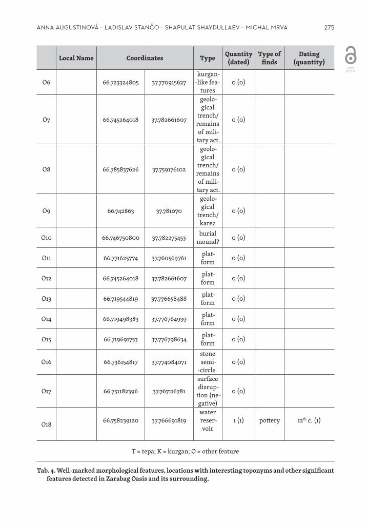
We further focused on the significant morphological features in the oasis and in the closer neighbourhood. These included settlement mounds – tepas – and nomad barrows – kurgans – as well as other well ‑marked features (Tab. 4).
Into the category of tepas (T1–7) we classify features, whose local names contain the word ‘tepa’ regardless of the presence of artefacts, or whose form fits the general concept of tepa – well ‑marked mounds in the landscape, again regardless of the artefacts or the chronological information they might bear. Secondly we focused on kurgans (K1–3) features that have already been investigated in a wider landscape context (Stančo et al. 2014). Three of them have been detected during our prospecting. The category ‘other’ (O1–13) represents features that cannot be classified within any of the aforementioned categories and are therefore described individually.
The most significant among the tepas is the Kosh Tepa (T1; Pl. 11/9) situated 1.2km south of Zarabag on the left side of the Zarabag – Pashkhurt road. The site has been used as a source of clay for the construction of houses in Zarabag and according to local people, whole big pottery vessels were brought back from there. Unfortunately, these were broken and used as building material along with the clay. The settlement mound has an oval ground plan approximately 50m in diameter. Its remains reach up to 2m. Its original shape and dimensions are, however, impossible to determine now. The whole mound was encircled by the remains of an irrigation ditch. In the northern part of the tepa, remains of a fireplace lying approximately at the level of the ground surrounding the tepa were unearthed. Carbon samples have been taken from the fireplace in order to subject them to the C14 analysis. The ceramic fragments from this site were mostly dated to the Late Bronze Age (the Sapalli culture; Fig. 1:1) and one belongs to the 4th century AD (Fig. 1:4). A lot of fragments come from the turn of the 18th and 19th century, with most of the pottery characteristic of the mountainous regions.
Considerable amounts of pottery fragments were found on the ground (O1) in close prox‑imity of Kosh Tepa, 40m westwards across the Zarabag ‑Pashkhurt road. The majority of the fragments which we collected as a representative sample were dated to the Early Iron Age (Yaz II/III). Few fragments belong to the Early Medieval (5th– 6th century) or the High Medieval Period (12th century). Thus, the fragments of the ware characteristic of the mountainous re‑
8 See no. 62 in the table with the description of an analogous site near Guzar, for instance.

273ANNA AUgUSTINOVÁ – LADISLAV STANČO – SHAPULAT SHAYDULLAEV – MICHAL MRVA
gions belong to the pre ‑modern era (18th–19th century). There was no noticeable mound above the current ground level.
The place called Kurukhsay Tepa (T2) – well ‑marked in the terrain – is situated about 15m above the spring (S5) in the dry watercourse called Kurukhsay Tapis, which – based on the information of locals – is full of water during the spring season. Although the surface of Ku‑rukhsay Tepe had been disturbed, there were no finds that could help with the dating of this site.
About 1.2km to the north of Zarabag lies a place called Karaul Tepa, marked in the topo‑graphic map as a point with an elevation of 1148.2m.a.s.l. There was nothing resembling rel‑ics of a tepa. Only on the top of the hill there was a small artificial mound (dm. 3m, h. 0.5m), probably belonging only to the Soviet era, when an iron transmitter tower was built here. According to our local informants the iron tower was taken to pieces only a few years ago.
Other three features (T4) are situated in the valley 1.7km to the south ‑east of Zarabag and they are visible also in the satellite images. They are along a dry river bed 1.5m deep and 2.5m wide. The one in the middle has a square ground plan with sides 4 × 4m and the foundations made of unfired bricks are still visible. The other two features have an oval ground plan with sides about 3.5 × 10m and they are about 1.5m higher than the surrounding surface. On the op‑posite bank of the dried river bed, there were relics of ploughing. While the local people still remembered the ploughing (dating it to the Soviet era), the features (T4) have according to our informants always had this form. The westernmost feature produced pottery fragments dated to the 12th and to the 18th–19th centuries.
In the north ‑east direction from Zarabag, there are three features reminiscent of tepas at the distance 200m, 250m and 450m from the road Zarabag – Kampirtepa. The northernmost one (T5) is called Dülana Tepa and has a circular shape with a diameter of 14m and a height of 2m above the surrounding surface. From the eastern side the feature is skirted by a small water canal, as was the case at the Kosh Tepa (T1). There were no pottery fragments that could help with the dating of the feature.
100m closer to the village, there is a similar feature (T6) called Vayrona or also Erona. The ground plan is again circular (dm. 13.5m) and the remains of the feature rise 2.3m above the surface. Similarly to Dülana Tepa (T5) and Kosh Tepa (T1), there is a shallow canal along the south side of the tepa. Unfortunately, there were, once again, no finds useful for chronological specification. An interesting morphological detail of this site is a small mound on its upper platform (dm. 2.5m, h. 0.3m) reminiscent of a barrow.
Closest to Zarabag is located a feature without any local name (T7) with a circular ground plan (dm. 16.5m, h. 1.7m). In contrast to Vayrona (T6), there is a depression on the upper plat‑form (dm. 1.5m, depth 0.2m).
On the left side of the road Zarabag – Shalkan at the place called Yakadarakh several kur‑gans have been detected near a low bulwark made of stones and clay with unclear purpose. Unfortunately, this area lies already in the border zone with Turkmenistan, where the use of GPS and camera is not allowed by the military.
A similar group of features was also identified near the point T7, in the northern part of Zarabag. The low long linear feature resembling a bulwark (O2) built of stones is about 25m long, 2.5m wide and 1m high. Not far from this linear mound there are three kurgans, simi‑larly to Yakadarakh. The first of them (K1) lies south of the line and is smaller (d. 2m) than the other two; these (K2 and K3) lie 50 m north of the line (O2) and their diameters measure 5m and 6.7m respectively.
The last category includes features whose determination is unclear or different from the two mentioned above.
274 STUDIA HERCYNIA XIX/1–2
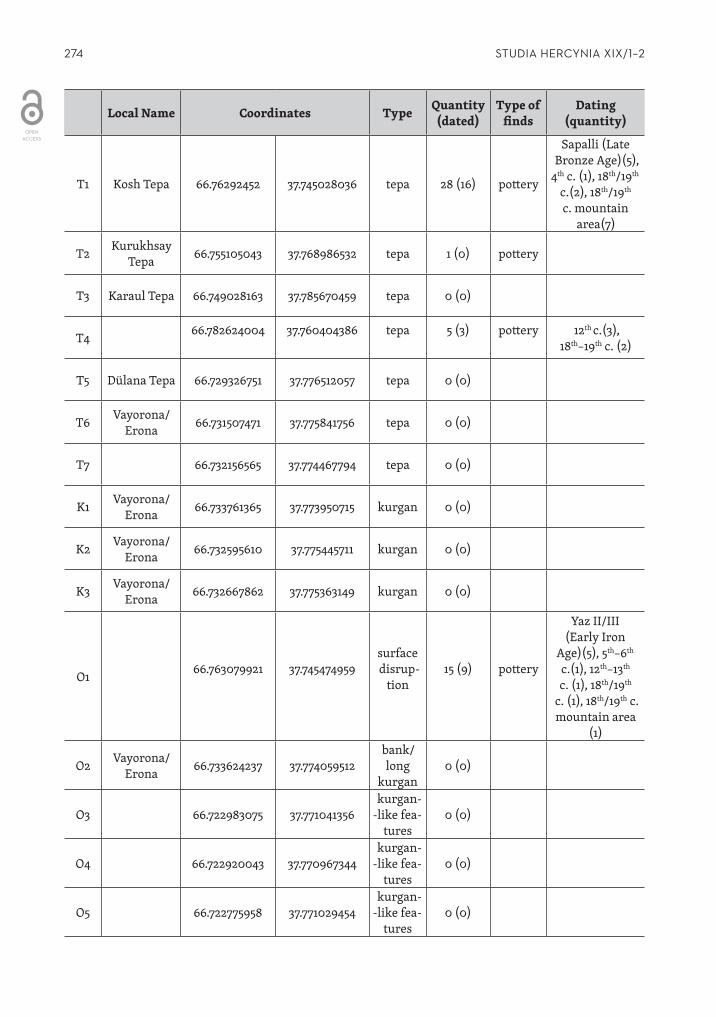
Local Name Coordinates Type Quantity (dated)
Type of finds
Dating (quantity)
T1 Kosh Tepa 66.76292452 37.745028036 tepa 28 (16) pottery
Sapalli (Late Bronze Age)(5),
4th c. (1), 18th/19th c.(2), 18th/19th c. mountain
area(7)
T2 Kurukhsay Tepa 66.755105043 37.768986532 tepa 1 (0) pottery
T3 Karaul Tepa 66.749028163 37.785670459 tepa 0 (0)
T4 66.782624004 37.760404386 tepa 5 (3) pottery 12th c.(3), 18th–19th c. (2)
T5 Dülana Tepa 66.729326751 37.776512057 tepa 0 (0)
T6 Vayorona/ Erona 66.731507471 37.775841756 tepa 0 (0)
T7 66.732156565 37.774467794 tepa 0 (0)
K1 Vayorona/ Erona 66.733761365 37.773950715 kurgan 0 (0)
K2 Vayorona/ Erona 66.732595610 37.775445711 kurgan 0 (0)
K3 Vayorona/ Erona 66.732667862 37.775363149 kurgan 0 (0)
O1 66.763079921 37.745474959surface disrup‑
tion15 (9) pottery
Yaz II/III (Early Iron
Age)(5), 5th–6th c.(1), 12th–13th c. (1), 18th/19th
c. (1), 18th/19th c. mountain area
(1)
O2 Vayorona/ Erona 66.733624237 37.774059512
bank/long
kurgan0 (0)
O3 66.722983075 37.771041356kurgan‑
‑like fea‑tures
0 (0)
O4 66.722920043 37.770967344kurgan‑
‑like fea‑tures
0 (0)
O5 66.722775958 37.771029454kurgan‑
‑like fea‑tures
0 (0)
275ANNA AUgUSTINOVÁ – LADISLAV STANČO – SHAPULAT SHAYDULLAEV – MICHAL MRVA
Local Name Coordinates Type Quantity (dated)
Type of finds
Dating (quantity)
O6 66.723324805 37.770915627kurgan‑
‑like fea‑tures
0 (0)
O7 66.745264018 37.782661607
geolo‑gical
trench/remains of mili‑tary act.
0 (0)
O8 66.785837626 37.759176102
geolo‑gical
trench/remains of mili‑tary act.
0 (0)
O9 66.742863 37.781070
geolo‑gical
trench/karez
0 (0)
O10 66.746750800 37.782275453 burial mound? 0 (0)
O11 66.771625774 37.760569761 plat‑form 0 (0)
O12 66.745264018 37.782661607 plat‑form 0 (0)
O13 66.719544819 37.776658488 plat‑form 0 (0)
O14 66.719498383 37.776764939 plat‑form 0 (0)
O15 66.719691753 37.776798634 plat‑form 0 (0)
O16 66.736154817 37.774084071stone semi‑
‑circle0 (0)
O17 66.751182396 37.767116781
surface disrup‑
tion (ne‑gative)
0 (0)
O18 66.758239120 37.766691819water reser‑voir
1 (1) pottery 12th c. (1)
T = tepa; K = kurgan; O = other feature
Tab. 4. Well ‑marked morphological features, locations with interesting toponyms and other significant features detected in Zarabag Oasis and its surrounding.

276 STUDIA HERCYNIA XIX/1–2
Near the spring (S1) in the north ‑west, there are four features resembling kurgans (O3–6) made of huge stones set along its circumference. Three of them have a circular ground plan (dm. 5m), one of them has an ovoid ground plan (6 × 2.5m).
The features with unclear purpose are represented by concentrations of regular pits. The square pits with sides 2.5 × 2.5m are grouped in one big square (O8). Its origin is probably modern and the likely explanations include geological trenches or foxholes dug out during a military exercise. The same explanation can be proposed for the line of circular regular pits (O7, O9) though they may possibly also be relics of a karez. This case will certainly merit a further study. We can compare these relics with others from Sauran in south Kazakhstan (Sala – Deom 2006).
A solitary feature (O10) is situated on the top of a hill 0.5km to the north of Zarabag near the Karaul Tepa. This circular feature (dm. 3m, h. 1.2m) recalls a barrow: a slight elevation of ground but with no marked stones characteristic of kurgans.
Another feature (O11) has the form of a marked flat rectangular platform (6 × 11m) on the bank of one riverbed, some 0.5km to the south ‑east of Zarabag. It is lined by big stones, but unfortunately no datable material was found here. Another smaller platform (O12) of a circular ground plan (dm. 2m) is situated on the opposite bank of the dry riverbed.
Three similar features (O13–15) are located 0.5km to the north ‑west of Zarabag. These have a circular ground plan (dm. 6m) and resemble relics of yurts, but their placement on a steep slope is not suitable for a settlement function.
A unique feature (O16) in the form of a stone semicircle around the spring/karez (S/K4) was detected in the north part of the village. A similar feature situated between the site of Burgut Kurgan and the Zarabag Oasis was subject to investigation of the Czech ‑Uzbekistani expedition. This feature – most likely of ritual purpose – was preliminarily interpreted by Sh. Shaydullaev as a ‘dakhma’, but final interpretation remains open.
No archaeological material was detected in the large surface disruption (O17) caused by earthworks during the building of a house at the east end of the village and it is therefore considered as a negative finding.
During our survey we also focused on the verification of the three find spots mentioned above (Dvurechenskaya et al. 2014). In two of them, there was no evidence of a well‑
‑marked feature or significant concentration of any dating material. The third of the spots published as a place with finds dated to the 3rd–4th century and to the 10th–11th century was identified as an old water reservoir (O18) with a canal situated about 20m above a small stream. On the opposite bank there is still a functioning water reservoir. Because of the traces of ploughing in the surroundings, it is possible, that the reservoir was still in func‑tion only a few decades ago.
intEnSivE SurfaCE SurvEy
In order to complement the data gained by the extensive surveys, we undertook an in‑tensive surface survey based on the methods implemented successfully in the Sherabad Oasis (Tušlová 2011; Tušlová 2012; in general cf. Kuna et al. 2004, 330–337) and adapted them to the conditions of the piedmont steppe. It was carried out on a field on the south‑
‑east edge of the village near the local high school. The investigated area covered a to‑tal surface of 49600sqm, that were divided into squares with sides of 40m. Each of the squares (sectors – SEC) was marked with a specific number (Pl. 11/10). We investigated 31 sectors whose conditions were suitable for prospecting (namely ploughed and bare

277ANNA AUgUSTINOVÁ – LADISLAV STANČO – SHAPULAT SHAYDULLAEV – MICHAL MRVA
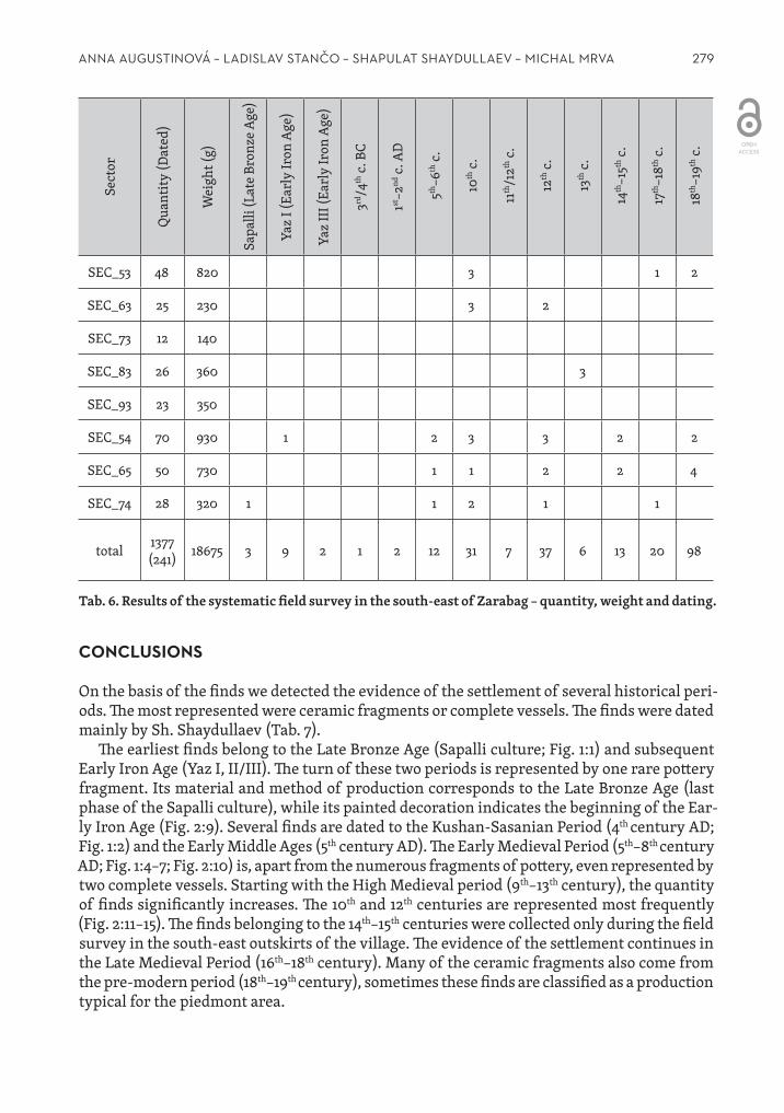
surface). The squares were walked by four prospectors in the way that covers the whole area in the same time limit 8min/sector. The survey was moreover complemented by the use of two metal detectors.9 Thanks to the use of metal detectors, three coins were discov‑ered. Despite their poor state of preservation, they can be preliminarily determined and dated to the Kushan and generally ancient period, while the last coin is a Khawarezmshah issue of the early 13th century. During the systematic field survey a total of 1377 pottery fragments weighing 18.68kg were obtained. Out of these, 241 fragments were suitable for closer dating (Tab. 5; Tab. 6). If we do not take into account the most common pre ‑modern fragments (18th–19th century), the period best represented in the assemblage is the 12th cen‑tury (with finds concentrated especially in north ‑east sectors) and the 10th century (which were spread out in the whole researched area). Other significantly represented epochs were the 5th–6th centuries and the High Medieval (14th–15th century) and the Late Medieval (17th–18th century) Periods. Completely missing is material from the turn of the era. More significant is the Early Iron Age. A few fragments represent also the Late Bronze Age (Sapalli).
× 13 12 11 × × × 2 1 × 2 2
× 23 22 21 × × 1 × 2 × 3 2 7
× 33 32 31 × 3 1 × 2 × × 2 3
× 43 42 41 × × 1 1 × 4 1 × 2
54 53 52 51 1 2 2 3 3 3 3
64 63 62 61 4 1 1 3 3 2 2 1 2
74 73 72 71 1 1 2 5 1
× 83 82 81 × × × 2 1 ×
× 93 92 91 × 2 × × ×
× × × 101 × × × × × × × × × × × ×
Numbers of the sectors
Yaz I–III (Early Iron Age) 5th–6th century 10th century 12th century
Tab. 5. Spatial distribution of finds of selected periods in the surveyed field.
9 The metal detector survey as well as the subsequent conservation and documentation of the finds were conducted by T. Smělý and M. Mašek. The coins have been studied by V. Novák (they will be published in Studia Hercynia XX/2 in 2016).

278 STUDIA HERCYNIA XIX/1–2
Sect
or
Qua
ntity
(Dat
ed)
Wei
ght (
g)
Sapa
lli (L
ate
Bron
ze A
ge)
Yaz
I (Ea
rly
Iron
Age
)
Yaz
III (E
arly
Iron
Age
)
3rd/4
th c.
BC
1st–2
nd c.
AD
5th–6
th c.
10th
c.
11th
/12th
c.
12th
c.
13th
c.
14th
–15th
c.
17th
–18th
c.
18th
–19th
c.
SEC_11 81 1174 1 1 2 3
SEC_21 153 1521 1 7 2
SEC_31 82 973 1 2 3 1
SEC_41 60 694 1 2 4
SEC_51 55 648 3 1 1
SEC_61 22 400 3 2 20
SEC_71 12 145 1 5
SEC_81 12 200 1 12
SEC_91 9 150 9
SEC_101 6 100 6
SEC_12 96 1000 3
SEC_22 64 1030 2 10
SEC_32 66 1110 1 2 4
SEC_42 45 550 1 2 16
SEC_52 30 550 2 1 1 2
SEC_62 18 150 4 1
SEC_72 25 390 1
SEC_82 14 150 2
SEC_92 16 280 2
SEC_13 77 1410 2 2 2 7
SEC_23 59 970 2 3 4
SEC_33 50 870 2 10
SEC_43 43 880 2 1 4 6
279ANNA AUgUSTINOVÁ – LADISLAV STANČO – SHAPULAT SHAYDULLAEV – MICHAL MRVA
Sect
or
Qua
ntity
(Dat
ed)
Wei
ght (
g)
Sapa
lli (L
ate
Bron
ze A
ge)
Yaz
I (Ea
rly
Iron
Age
)
Yaz
III (E
arly
Iron
Age
)
3rd/4
th c.
BC
1st–2
nd c.
AD
5th–6
th c.
10th
c.
11th
/12th
c.
12th
c.
13th
c.
14th
–15th
c.
17th
–18th
c.
18th
–19th
c.
SEC_53 48 820 3 1 2
SEC_63 25 230 3 2
SEC_73 12 140
SEC_83 26 360 3
SEC_93 23 350
SEC_54 70 930 1 2 3 3 2 2
SEC_65 50 730 1 1 2 2 4
SEC_74 28 320 1 1 2 1 1
total 1377 (241) 18675 3 9 2 1 2 12 31 7 37 6 13 20 98
Tab. 6. Results of the systematic field survey in the south ‑east of Zarabag – quantity, weight and dating.
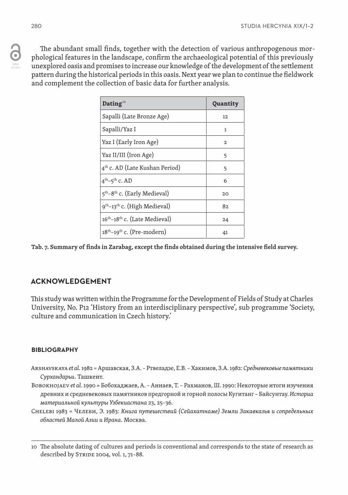
ConCluSionS
On the basis of the finds we detected the evidence of the settlement of several historical peri‑ods. The most represented were ceramic fragments or complete vessels. The finds were dated mainly by Sh. Shaydullaev (Tab. 7).
The earliest finds belong to the Late Bronze Age (Sapalli culture; Fig. 1:1) and subsequent Early Iron Age (Yaz I, II/III). The turn of these two periods is represented by one rare pottery fragment. Its material and method of production corresponds to the Late Bronze Age (last phase of the Sapalli culture), while its painted decoration indicates the beginning of the Ear‑ly Iron Age (Fig. 2:9). Several finds are dated to the Kushan ‑Sasanian Period (4th century AD; Fig. 1:2) and the Early Middle Ages (5th century AD). The Early Medieval Period (5th–8th century AD; Fig. 1:4–7; Fig. 2:10) is, apart from the numerous fragments of pottery, even represented by two complete vessels. Starting with the High Medieval period (9th–13th century), the quantity of finds significantly increases. The 10th and 12th centuries are represented most frequently (Fig. 2:11–15). The finds belonging to the 14th–15th centuries were collected only during the field survey in the south ‑east outskirts of the village. The evidence of the settlement continues in the Late Medieval Period (16th–18th century). Many of the ceramic fragments also come from the pre ‑modern period (18th–19th century), sometimes these finds are classified as a production typical for the piedmont area.
280 STUDIA HERCYNIA XIX/1–2
The abundant small finds, together with the detection of various anthropogenous mor‑phological features in the landscape, confirm the archaeological potential of this previously unexplored oasis and promises to increase our knowledge of the development of the settlement pattern during the historical periods in this oasis. Next year we plan to continue the fieldwork and complement the collection of basic data for further analysis.
Dating 10 Quantity
Sapalli (Late Bronze Age) 12
Sapalli/Yaz I 1
Yaz I (Early Iron Age) 2
Yaz II/III (Iron Age) 5
4th c. AD (Late Kushan Period) 5
4th–5th c. AD 6
5th–8th c. (Early Medieval) 20
9th–13th c. (High Medieval) 82
16th–18th c. (Late Medieval) 24
18th–19th c. (Pre ‑modern) 41
Tab. 7. Summary of finds in Zarabag, except the finds obtained during the intensive field survey.10
aCknowlEdgEMEnt
This study was written within the Programme for the Development of Fields of Study at Charles University, No. P12 ‘History from an interdisciplinary perspective’, sub programme ‘Society, culture and communication in Czech history.’
BiBliograPHy
Arshavskaya et al. 1982 = Аршавская, З.А. – Ртвеладзе, Е.В. – Хакимов, З.А. 1982: Средневековые памятники Сурхандарьи. Ташкент.
Bobokhojaev et al. 1990 = Бобохаджаев, А. – Аннаев, Т. – Рахманов, Ш. 1990: Некоторые итоги изучения дрeвних и средневековых памятников предгорной и горной полосы Кугитанг – Байсунтау. Историа материальной культуры Узбекиастана 23, 25–36.
Chelebi 1983 = Челеби, Э. 1983: Книга путешествий (Сейахатнаме) Земли Закавказья и сопредельных областей Малой Азии и Ирана. Москва.
10 The absolute dating of cultures and periods is conventional and corresponds to the state of research as described by Stride 2004, vol. 1, 71–88.
281ANNA AUgUSTINOVÁ – LADISLAV STANČO – SHAPULAT SHAYDULLAEV – MICHAL MRVA
Dvurechenskaya et al. 2014 = Двуреченская, Н.Д. – Двуреченский, О.В. – Мокробородов, В.В. – Рукавишникова, И.В. – Рукавишников, Д.В. 2014: Маршрутные исследования на юге Узбекистана в 2013 году. Краткие сообщения Института археологии 236, 69–82.
Danielisová, A. – Stančo, L. – Shaydullaev, A. 2010: Preliminary Report of Archaeological Survey in Sherabad District, South Uzbekistan in 2009. Studia Hercynia XIV, 67–90.
Karmysheva 1976 = Karmysheva, Б.Х. 1976: Очерки этнической истории южных районов Таджикистана и Узбекистана. Москва.
Kuna, M. ed. 2004: Nedestruktivní archeologie. Teorie, metody a cíle. Praha.Mkrtychev et al. 2005 = Мкртычев, Т.К. – Болелов, С.Б. – Ильясов Д.Я.: Исследования на юге Узбекистана.
Археологические открытия 2004 года. Москва, 524–528.Rtveladze 1974 = Ртвеладзе, Е.В. 1974: Разведочное изучение Бактрийских памятников на юге
Узбекистана. In: Маccон, В.М. (ed.): Древняя Бактрия. Ленинград, 74–85.Rtveladze – Khakimov 1973 = Ртвеладзе Э.В. – Хакимов, З.А. 1973: Маршрутные исследования
памятников Северной Бактрии. In: Из истории античной культуры Узбекистана. Ташкент, 10–34.Sala – Deom 2006 = Сала, Р. – Деом, Ж.M. 2006: 235 кяризов региона Сауран. In: География Казахстана:
содержание, проблемы, перспективы. Материалы Международной научно ‑практической конфе‑ ренции 20–22 апреля 2006 г. Алматы, 342–361.
Stančo et al. 2014 = Stančo, L. – Shaydullaev, Sh. – Bendezu ‑Sarmiento, J. – Pažout, A. – Vondrová, H.: Kayrit Burial Site (South Uzbekistan). Preliminary Report for Season 2014. Studia Hercynia XVIII/1–2, 31–41.
Stančo, L. 2009: The Activities in Uzbekistan in the 2008 Season: Testing the Google Earth Programme as a Tool for Archaeological Prospecting. Studia Hercynia XIII, 115–122.
Stride S. 2004: La Géographie Archéologique de la Province du Surkhan Darya (Bactriane du Nord, Ouzbékistan du Sud). Unpublished dissertation at the Universite Pantheon ‑Sorbonne (Paris), 5 vols.
Tušlová, P. 2011: Systematical Field Survey in Sherabad District, South Uzbekistan. Studia Hercynia XV/2, 17–25.
Tušlová, P. 2012: Systematic Field Survey in the Sherabad District, Report of the 2011 Season. Studia Hercynia XVI/2, 15–21.
Anna AugustinováInstitute of ArchaeologyFaculty of Arts, Charles University in PragueCeltná 20, CZ‑11000, Prague [email protected]
Shapulat ShaydullaevTermez State University190100, 42, Fayzulla KhojaevTermez, [email protected]
Ladislav StančoInstitute of Classical ArchaeologyFaculty of Arts, Charles University in PragueCeltná 20, CZ‑11000, Prague [email protected]
Michal MrvaInstitute of ArchaeologyFaculty of Arts, Charles University in PragueCeltná 20, CZ‑11000, Prague [email protected]
310 STUDIA HERCYNIA XIX/1–2
Pl. 11/1: Detail of the research area as represented in the Soviet (‘gen. Shtab’) topographic map in 1983; 1: 100 000.
Pl. 11/2: Overview of the surveyed polygons represented by cemeteries and private plots in Zarabag (compiled by A. Augustinová).

311PLATES / PŘÍLOHY
Pl. 11/3: Overview of the water sources in Zarabag Oasis – springs and karezes – so far detected (compiled by A. Augustinová).
Pl. 11/4: Kurukhsay Buloq (S5). Pl. 11/5: A relic of a karez in the north ‑west part of the Zarabag Oasis (K10).

312 STUDIA HERCYNIA XIX/1–2
Pl. 11/6: An overview of two documented sites with remains of yurt camps at the outskirts of the Zarabag Oasis (compiled by A. Augustinová).
Pl. 11/7: A group of small round terraces interpreted as remains of yurts (cf. Pl. 11/9B), near the Zarabag Oasis (highli‑ghted in green).
Pl. 11/8: A round terrace interpreted as remain of a yurt (cf. Pl. 11/9:B).

313PLATES / PŘÍLOHY
Pl. 11/9: South view of Kosh Tepe with remains of a canal on the left (T1).
Pl. 11/10: The layout of sectors that were investi‑gated during the intensive field survey on the selected field at the south ‑east of Zarabag (created by A. Augustinová).
Pl. 11/11: The stone stele from the oldest cemetery in Zarabag – Huyaobozi Vali (B1).
Pl. 11/12: The clay seal with a depiction of a pran‑cing ibex and its imprint (B6).