Embed Size (px)
Citation preview

Archaeological monitoring and recording onland to the rear of Tillbrooks Garage,
High Street, Wethersfield, Essex, CM7 4BY
March 2017
by Laura Pooleywith contributions by Stephen Benfield
figures by Laura Pooley and Emma Holloway
fieldwork by Ben Holloway and Harvey Furniss
commissioned by Steven Graystonon behalf of Saxon Ridge Properties Ltd
NGR: TL 1178 1321 (centre)Planning ref.: 16/01917/FUL
CAT project ref.: 17/02eECC code: WFTG17
Braintree Museum accession code: tbcOASIS ref.: colchest3-275768
Colchester Archaeological TrustRoman Circus House,Roman Circus Walk, Colchester, Essex, CO2 7GZ
tel.: 01206 501785
email: [email protected] CAT Report 1083 May 2017

Contents
1 Summary 12 Introduction 13 Archaeological background 14 Results 35 Finds 5 6 Discussion 67 Acknowledgements 68 References 69 Abbreviations and glossary 710 Contents of archive 711 Archive deposition 7
Appendix 1 Context list 9
Figures after p9
OASIS summary sheet
List of photographs, tables and figures
Cover: general site shot
Map 1 Chapman and André map of 1777 2Map 2 Six-inch 1896 OS map (ESSEX XV.SE) overlaid on modern 2
street map (site indicated by blue arrow) showing range of buildings on the development site fronting onto the high street
Photograph 1 Wall foundation F1, looking SE 3Photograph 2 Soakaway F2, looking SW 4Photograph 3 Wall foundation F3, looking SSE 4Photograph 4 Foundation trenches, looking NNE 5
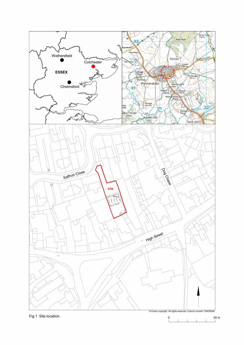
Fig 1 Site locationFig 2 ResultsFig 3 Feature and representative sections

CAT Report 1083: Archaeological monitoring and recording on land at Tillbrooks Garage, High Street, Wethersfield,Essex – March 2017
1 SummaryArchaeological monitoring and recording was carried out on land at Tillbrooks Garage, High Street, Wethersfield, Essex during groundworks for the construction of two new dwellings. Located in the centre of the historic medieval settlement, groundworks revealed two red-brick wall foundations and a red-brick soakaway of post-medieval/ modern or modern date. These are likely associated with a range of buildings shown on the 1896 OS map fronting onto the High Street and continuing on a SE/NW alignment into the development site.
2 Introduction (Fig 1)
This is the archive report for archaeological monitoring and recording at Tillbrooks Garage, High Street, Wethersfield, Essex which was carried out on 1st-9th March 2017.The work was commissioned by Steven Grayston, on behalf of Saxon Ridge Properties Ltd, in advance of the construction of two new dwellings. The work was undertaken by Colchester Archaeological Trust (CAT).
In response to consultation with Essex County Council Place Services (ECCPS), Historic Environment Advisor Teresa O'Connor advised that in order to establish the archaeological implications of this application, the applicant should be required to commission a scheme of archaeological investigation in accordance with the National Planning Policy Framework (DCLG 2012).
All archaeological work was carried out in accordance with a written scheme of investigation (WSI) prepared by CAT in response to an archaeological brief and agreed with ECCPS (CAT 2016).
In addition to the brief and WSI, all fieldwork and reporting was done in accordance with English Heritage’s Management of Research Projects in the Historic Environment (MoRPHE) (English Heritage 2006), and with Standards for field archaeology in the East of England (EAA 14 and 24). This report mirrors standards and practices contained in the Institute for Archaeologists’ Standard and guidance for archaeological watching brief (CIfA 2014a) and Standard and guidance for the collection, documentation, conservation and research of archaeological materials (CIfA 2014b).
3 Archaeological backgroundThe following archaeological background utilises the Essex Historic Environment Record (EHER) held at Essex County Council, County Hall, Chelmsford.
The proposed development site lies within the historic medieval settlement of Wethersfield. It is situated to the rear of the High Street and fronted by a number of listed buildings dating from the 15th century onwards, many of relatively high status. It lies immediately adjacent to a Grade II* listed building, St George's House, and within the Conservation Area. The historic OS maps show there to have been a number of outbuildings to the rear of the High Street houses which are likely to have been associated with domestic or industrial activities. These no longer survive, however the foundations may be preserved below ground.
1

CAT Report 1083: Archaeological monitoring and recording on land at Tillbrooks Garage, High Street, Wethersfield,Essex – March 2017
Map 1 Chapman and André map of 1777
Map 2 Six-inch 1896 OS map (ESSEX XV.SE) overlaid on modern street map (site indicated by blue arrow) showing range of buildings on the development site fronting onto the high street
2
NLS Historic Maps Subscription API layer © Getmapping plc © 2017 GeoEye © 2017 Intermap © 2017 Microsoft Corporation © 2017 HERE ©

CAT Report 1083: Archaeological monitoring and recording on land at Tillbrooks Garage, High Street, Wethersfield,Essex – March 2017
4 Results (Figs 2-3)
All groundworks were carried out by the contractor using a mechanical excavator underthe supervision of a CAT archaeologist.
An inspection pit, measuring approximately 6m long, 1.7m wide by 1.1m deep was excavated on the SE edge of the development site. A red-brick wall (F1) aligned SE/NW was recorded on the same alignment as the SE/NW walls of the existing garage complex. Construction rubble associated with this wall was dated to post-1910.
Approximately 74m linear of foundation trenches were excavated measuring c 0.6-0.7mwide by 0.8-1.45m deep. The foundations were excavated through modern demolition debris associated with site clearance works (L1, 0.14-0.35m thick) and a dark grey/brown sandy-silt subsoil (L2, 0.25-1.2m thick) onto natural sands (L3).
A second red-brick wall foundation (F3) dated to the late 18th – early 20th century was also aligned SE/NW. This is possibly a continuation of wall foundation F1 to the NW. To the NNE was a soakaway made of red-bricks dated to the late 17th – 19th century. It was a circular structure approximately 1.15m in diameter. A modern service trench was also recorded.
Photograph 1 Wall foundation F1, looking SE
3

CAT Report 1083: Archaeological monitoring and recording on land at Tillbrooks Garage, High Street, Wethersfield,Essex – March 2017
Photograph 2 Soakaway F2, looking SW
Photograph 3 Wall foundation F3, looking SSE
4

CAT Report 1083: Archaeological monitoring and recording on land at Tillbrooks Garage, High Street, Wethersfield,Essex – March 2017
Photograph 3 Foundation trenches, looking NNE
5 Findsby Stephen Benfield
Only a small quantity of finds were retained all are of post-medieval/modern or modern date. The finds consist of a few selected whole or interesting pieces from F1 and brick samples from F2 and F3. One of the finds (glass bottle) from F1 shows that the featurepost-dates 1910.
F1 (1)A few modern finds were retained from F1. These are listed and described below. A Foster Clark fruit juice bottle among these finds post-dates 1910.
Pottery:Sherd from a white stoneware preserve jar.D]UNDEE / MARMALADE / P]RIZE MEDAL FOR MARMA[LADE / LONDON, 1862
Glass:Camp coffee bottle, complete.One face PATERSON’S one face CAMP / COFFEE / & CHICORY one face GLASGOWCamp coffee was started by Paterson’s in 1876. The product is still available today.
Bottle complete (pale blue/green tint to glass). On base ANGER / ...3 / EMULSIONAlthough emulsions are used orally to treat a number of conditions the word anger could suggest inflammation and redness. The product here might possibly have been an emulsion bath additive to help treat sub-acute or chronic plaque psoriasis (this type of psoriasis involves areas of raised, red, sometimes itchy, patches of skin, covered with silvery scales but without any blistering or tenderness). The patches often occur on
5

CAT Report 1083: Archaeological monitoring and recording on land at Tillbrooks Garage, High Street, Wethersfield,Essex – March 2017
the elbows, knees, lower back and scalp. The treatment is added to water when bathing.
Small square bodied drink (juice) bottle (pale blue/green tint to glass, height of bottle 105mm) One face FOSTER CLARK LTD / MAIDSTONE opposing face EIFFEL TOWER / FRUIT JUICESFoster Clarke began trading in 1891 and became a limited company after 1910. Although sold to OXO in 1965 it appears that the company name is still used today on some fruit juice products.
Metal:Pressed metal cover/flap with convex face, and raised word LETTERS, possibly a letterbox flap or flap/cover for posting box, riveted attachment at one end (broken off at other) and small horizontal projection for attachment on middle of bottom edge, length of pressed curving plaque 115mm (135mm with surviving rivet attachment), width 28mm (weight 30g).
F2 (2)Complete brick (sample), not frogged, orange sandy fabric, relatively sharp edges, 210mm x 105mm x 62mm, some white lime mortar on one corner (weight 2474g). Broadly dated as late 17th-19th century.
F3 (3)Complete brick (sample), not frogged, relatively sharp edges with creasing in edge faces, red/red-brown sandy fabric with occasional small stone, black firing marks (vertical stripes) on one edge, 213mm x 110mm x 61mm, sandy white lime mortar on faces and ends but not on sides (weight 2734g). Probably a stock-type brick. Dated late 18th-early 20th century.
6 DiscussionArchaeological monitoring at Tillbrooks Garage, Wethersfield revealed two red-brick wall foundations (F1 and F3) and a red-brick soakaway (F2) of post-medieval/modern and modern date. The 1896 OS map (Map 2) shows a range of buildings on the development site which fronted onto the High Street. Parts of these buildings are probably still standing as garages on the far SE edge of the site. Wall foundations F1 and F3 show that this range of buildings continued for approximately 12m onto the development site, and soakaway F2 was probably associated with them.
7 AcknowledgementsCAT thanks Steven Grayston and Saxon Ridge Properties Ltd for commissioning and funding the work. The project was managed by C Lister, fieldwork was carried out by B Holloway and H Furniss. Figures are by L Pooley and E Holloway. The project was monitored for ECCPS by Teresa O'Connor.
8 ReferencesNote: all CAT reports, except for DBAs, are available online in PDF format at http://cat.essex.ac.uk
CAT 2014 Health and Safety PolicyCAT 2016 Written Scheme of Investigation (WSI) for archaeological
monitoring on land to the rear of Tillbrooks Garage, High Street, Wethersfield, Essex, CM7 4BY
CIfA 2014a Standard and guidance for archaeological watching briefsCIfA 2014b Standard and guidance for the collection, documentation,
conservation and research of archaeological materials
6
CAT Report 1083: Archaeological monitoring and recording on land at Tillbrooks Garage, High Street, Wethersfield,Essex – March 2017
DCLG 2012 National Planning Policy Framework. Dept of Communities andLocal Government.
EAA 14 2003 Standards for field archaeology in the East of England, East Anglian Archaeology, Occasional Papers, 14. ed. D Gurney
EAA 24 2011 Research and archaeology revisited: A revised framework for the East of England, East Anglian Archaeology Occasional Papers 24, by M Medlycott
EnglishHeritage
2006 Management of Research Projects in the Historic Environment,MoRPHE (English Heritage)
9 Abbreviations and glossaryCAT Colchester Archaeological TrustCIfA Chartered Institute for Archaeologistscontext specific location of finds on an archaeological siteECCHEA Essex County Council Historic Environment AdvisorECCPS Essex County Council Place ServicesEHER Essex Historic Environment Recordfeature (F) an identifiable thing like a pit, a wall, a drain: can contain ‘contexts’ layer (L) distinct or distinguishable deposit (layer) of materialmedieval period from AD 1066 to c 1500modern period from c AD 1800 to the presentnatural geological deposit undisturbed by human activityNGR National Grid ReferenceOASIS Online AccesS to the Index of Archaeological InvestigationS,
http://oasis.ac.uk/pages/wiki/Main post-medieval period from c AD 1500 to c 1800section (abbreviation sx) vertical slice through feature/s or layer/swsi written scheme of investigation
10 Contents of archiveFinds: not retainedPaper and digital record
One A4 document wallet containing: The report (CAT Report 1083)
ECC evaluation brief, CAT written scheme of investigation Original site record (feature and layer sheets, finds record, plans) Site digital photos and log, architectural plans, attendance register, risk assessment
11 Archive depositionThe paper and digital archive is currently held by the Colchester Archaeological Trust atRoman Circus House, Roman Circus Walk, Colchester, Essex CO2 7GZ, but will be permanently deposited with Braintree Museum under accession code: tbc
© Colchester Archaeological Trust 2017
7

CAT Report 1083: Archaeological monitoring and recording on land at Tillbrooks Garage, High Street, Wethersfield,Essex – March 2017
Distribution list:Steven Grayston, Saxon Ridge Properties LtdHistoric Environment Advisor, Essex County Council Place ServicesEssex Historic Environment Record, Essex County Council
Colchester Archaeological TrustRoman Circus House,Roman Circus Walk, Colchester, Essex, CO2 7GZ
tel.: 01206 501785email: [email protected]
Checked by: Philip CrummyDate: 24.5.2017
8

CAT Report 1083: Archaeological monitoring and recording on land at Tillbrooks Garage, High Street, Wethersfield,Essex – March 2017
Appendix 1 Context list
Context FindsNo.
Type Description Date
F1 1 Wall foundation
Friable, dry, dark brown/black sandy-silt, 75% brick/tile
Post-1910
F2 2 Soakaway Firm, dry, dark grey/brown sandy-silt with 25% brick/tile
Late 17th-19th century
F3 3 Wall foundation
Firm, yellow/orange/brown silty-sand with 90% brick
Late 18th-early 20th century
L1 - Topsoil Friable, dry, medium-dark grey/black sandy-silt, 10% stone, 10% gravel and 20% brick/tile; originally sealed by a thick layer of concrete
Modern
L2 - Subsoil Friable, dry, dark grey/black sandy-silt, 5% stone, 5% gravel and 2% brick/tile
-
L3 - Natural Natural yellow-orange sands -
9
0 50 m
© Crown copyright. All rights reserved. Licence number 100039294.
Wethersfield
Colchester
Chelmsford
ESSEX
Saffron Close
Dog C
hase
High Street
site
Fig 1 Site location.

F1 in sx
F1 in sx
F3 in sx
garages
F2
© Crown copyright. All rights reserved. Licence number 100039294.
Fig 2 Results
modern services
0 10 m