Embed Size (px)
Citation preview

Archaeological Investigation
at Site IV-266/320, KP211/212, Atskuri Village, Akhaltsikhe Region
Prepared by:
Vakhtang Licheli, Giorgi Rcheulishvili, Merab Kasradze, R. Rusishvili,
Nino Kalandadze, Nana Papuashvili, L. Kazakhishvili, Gela Gobejishvili
Otar Lordkipanidze Centre of Archaeology of the Georgian National Museum
14, Uznadze Street
Tbilisi 0102, Georgia
Submitted to:
BTC/SCP Pipeline Company
38, Saburtalo Street
Tbilisi 0194, Georgia
The work was carried out on a contract basis
C-06-BTC-116628
C-06-SCP-116630
HL-241
2007

Archaeological Investigations at Site IV-266/ 320, KP211/212 Atskuri Village, Akhaltsikhe District
- 2 -
TABLE OF CONTENTS
Summary
List of Figures
1.0 Introduction
2.0 Environmental Background
2.1 Site Location and Description
2.2 Past Environment
2.3 Land Use History
3.0 Cultural Background
3.1 Prehistoric and Historic Contexts
3.2 Summary of Previous Research
4.0 Methodology
4.1 Field Methods
4.2 Laboratory Methods
5.0 Results
5.1 Basic Data Summary
5.2 Features
5.3 Artifacts
6.0 Interpretation
7.0 Summary, Conclusions, Recommendations
7.1 Summary
7.2 Recommendations
8.0 References Cited

Archaeological Investigations at Site IV-266/ 320, KP211/212 Atskuri Village, Akhaltsikhe District
- 3 -
Summary
The present report represents the results of archaeological research carried out in connection with the construction of the BTC pipeline. The investigation was conducted at Site IV-270, located in the environs of the village of Atskuri, Samtskhe, Akhaltsikhe Region, at KP211 and KP212. The archaeological work was carried out by the Borjomi Archaeological Expedition of the Otar Lordkipanidze Institute of Archaeology under the supervision of Vakhtang Licheli in 2004-2005. As a result of the excavations eight wine cellars of the 11th-12th centuries were discovered and studied. We studied their technical equipment, and determined various technological details, the special financial aspects of the business, and the nature of the materials used in their construction. Thanks to a series of interdisciplinary studies, light was thrown on a wide range of agricultural products (wheat, rye, grapes, olive production, and large- and small-scale animal husbandry). Fresh information on Georgian viticulture was obtained in the course of the investigation. In one of the wine cellars evidence for a highly unusual religious ritual was found, thus confirming the existence of a custom that had hitherto only been known in the ethnographic literature. List of tables
Pl. I. Map of Georgia Pl. II. Site Map of Excavations, Showing Trench Locations Pl. III. Site IV 320, Map Pl. IV. Site IV 266, Map Pl. V. Atskuri, Site IV 320, Trench No.9, Map Pl. VI. Atskuri, Site IV 320, Trench No.12, Map Pl. VII. Atskuri, Site IV 320, Trench No.12, Sections NN 1-1 and 2-2 Pl. VIII. Atskuri, Site IV 266, Trenches NN 20 and 21. Maps Pl. IX. Atskuri, Site IV 320, Trench No.18, Map Pl. X. a) Atskuri, Trench No.9, Wine Cellar, View from the South b) Atskuri, Trench No.12, Press, View from the West c) Atskuri, Trench No.20, cavity, View from the East Pl. XI. Atskuri, the Medieval Pottery from Sites IV-266 and IV-320 Pl. XII. a) Atskuri, Cavity in Trench No.20 b) Plate inscribed �St. George� from Trench No.9 Pl. XIII. Atskuri, Glazed Pottery from Sites Nos. 266 and 320 Pl. XIV. Atskuri, Site No.266, Metal Items
Archaeological Investigations at Site IV-266/ 320, KP211/212 Atskuri Village, Akhaltsikhe District
- 4 -
1) Lead Finger Ring; 2) Metal Items before Cleaning 3) Metal Items after Cleaning Pl. XV. Atskuri, Site No. 266, Bone Material 1) Cow and 2) Pig Remains Pl. XVI. Atskuri, Paleobotanical Material from the Trenches NN 20 and 21 Pl. XVII. Atskuri, Crop Farming Elements, x600. 1-7: Cultivated Grapes (Vitis vinifera); 8, 10: Hazelnut (Corylus); 9: Walnut (Juglans regia); 11, 12: Olive (Olea europea); 13, 16: goosefoot (Chenopodium album type); 14: Succory (Cichorioidae); 15: Polygonum aviculare
type; 17: Thistle (Carduus); 18-20: Wheat (Triticum). Pl. XVIII. Atskuri, Forest Elements, x600. 1: Pine (Pinus); 2: Spruce (Picea); 3: Oleaster (Elaeagnus type); 4: Beech (Fagus orientalis); 5: Oak (Quercus); 6, 8: Hornbeam (Carpionus
caucasica); 7: Oriental hornbeam (Carpionus Orientalis); 9: Alder (Alnus); 10: Honeysuckle (Lonicera); 11: Pteris (Pteris type); 12: Ephedra (Ephedra); 13: Fern (Pteris cretica); 14: Polypodiaceae; 15: Ophioglossum vulgate. Pl. XIX. Atskuri, Textile Fibres: 1-4: Cotton; 5,6: Lint, x800. Pl. XX. Atskuri, Textile Fibres: Remains of Cotton Thread, x800.

Archaeological Investigations at Site IV-266/ 320, KP211/212 Atskuri Village, Akhaltsikhe District
- 5 -
1.0 Introduction
Purpose of the investigation
The purpose of the project was to investigate and conserve Sites IV-266, 279, 320 located at KP211 and KP212 of the pipeline near the village of Atskuri, Samtskhe, Akhaltsikhe Region. Eight wine cellars dating back to the 11th-17th centuries were discovered and studied as a result of excavations. Project sponsor
Field investigations and post-excavation laboratory processing and analysis were funded by the BTC Pipeline Company. Permits and contract numbers
The Permit issued by the Archaeological Board of the Georgian Academy of Sciences licensed Dr Vakhtang Licheli to conduct archaeological excavations at the Atskuri section of the BTC Pipeline. Field work was conducted based on the following contracts: C-03-BTC-52923, C-03-SCP-52927, HL-194 and 197. Legal requirements
According to Georgian legislation the Archaeological Board of the Georgian Academy of Sciences authorized the applicant from the Centre for Archaeological Studies (the name of the organization when the permit was issued; its current name is the Otar Lordkipanidze Centre of Archaeology of the Georgian National Museum) upon his request to conduct archaeological excavations. The archaeological work was to be conducted according to the existing regulations. Dates of the investigation
The field and laboratory study was carried out in 2004-2005. One wine cellar was destroyed in the course of pipeline construction. Archaeological investigation of this wine cellar was not possible Final disposition and repository Address
The finds and records from the site will be deposited with the Otar Lordkipanidze Centre of Archaeology at the following address: 14, Uznadze Str. Tbilisi 0102, Georgia Tel.: 95 29 20

Archaeological Investigations at Site IV-266/ 320, KP211/212 Atskuri Village, Akhaltsikhe District
- 6 -
2.0 Environmental Background
Akhaltsikhe District is a part of the historical province of Samtskhe. It is situated in the Akhaltsikhe depression and covers the Mtkvari valley between Muskha and Atsquri and the Potskhovi Valley below the Kvabliani tributary. To the north the district is bordered by the Meskheti range while to the south it is surrounded by the Erusheti range. Most of the land in the district consists of Oligocene sandstone and clay, but a small part (the slopes of the Erusheti range) consists of Eocene tuff-breccia, tuff and andesite. The relief is diverse and contains flat terraces, valleys running north to south, small depressions and volcanic mountains. In most parts of Akhaltsikhe District there is a mountain steppe climate. Winters are cold with minor snowfalls, while summers are long and warm. At the bottom of the Akhaltsikhe depression the average temperature in January is -3.8º C, and in August +20.5º C; the average annual precipitation does not exceed 520 mm, while in the mountainous zone it reaches 1200 mm. Rock xerophytic bushes and shrubs (juniper, blackthorn) prevail in the floral community of the district as well as xerophytic perennial herbaceous plants. The vegetation of the lower zone of the mountain forest includes oak and hornbeam, while fir and pine grow in its upper zone. The wildlife includes deer, fawn, chamois, wild boar, otter, lynx, wild cat, bear, wolf, fox, badger, marten, weasel, rabbit, squirrel, water vole, forest mouse. There are numerous wild pigeons, turtle-doves, crows, magpies, starlings, quails. Rivers contain trout, barbell, khramuli. 2.1 Site Location and Description
The sites discovered within the Pipeline ROW are located between the villages Atskuri and Tkemlana, on the plateau on the left bank of the Mtkvari river, at 950-965m above sea level. One site was found in the place called Navenakhevi, and another some 300m to the east, on the so-called Palmeturi. This area is located on the both sides of the road leading from Atskuri to Tkemlana. 2.2 Past Environment
Research on the paleontological and paleobotanical material from Olduvai and the early Acheulian periods has great importance for the study of the environmental development of Georgia in the Quaternary period (between the Pleistocene and early Holocene). Before the Mindel period (0.6-0.7million years ago) in present day Georgia there was a moderately warm climate and a savannah-type landscape. A dramatic change of climate took place at the beginning of the Mindel period. This phenomenon occurred in Georgia too, although, due to its southern location, there was no large-scale fall of temperature here. After this the Mindel-Riss warm period began which was followed by the Riss period, the greatest glaciation in the history of the Earth. The Riss glaciation was followed by the warm interglacial epoch, which can be dated to 120-70,000 years ago. About 70,000 ago there began dramatic fall in temperature, which brought about the Wurm glaciation. This glaciation strongly affected human settlement patterns in the Stone Age. Because of the severe conditions humans left the upland and highland areas and used them only during the warm summer season, mainly for hunting. In this period in Georgia humans lived only in the plains. The transition from old to new Stone Age coincided with the transitional stage from the upper Pleistocene to the Holocene (approximately 10-12,000 years ago). At this time there occurred dramatic changes in environmental conditions and it began to get much warmer.

Archaeological Investigations at Site IV-266/ 320, KP211/212 Atskuri Village, Akhaltsikhe District
- 7 -
In the Mesolithic period humans went back to the highlands which had been abandoned during the previous Wurm glaciation. Since then humans have lived in every landscape zone in Georgia. During the period after the Holocene glaciation the environment did not change much. (Georgian Archaeology, 1991, pp. 52-69). Thanks to faunal and floral data we can to a certain extent reconstruct the palaeo-ecological picture of Georgian territory in the Pleistocene. No substantial environmental changes occurred between the early Pleistocene and early Holocene. The climate was moderately arid and warm (Gabunia, Vekua, 1997, pp. 13-15). The landscape of eastern Georgia consisted of mountain ranges of medium height traversed by deep gorges. Studies of floral fossils suggest that in the forests of the eastern Georgian plains there grew thermophilic tree species and those suited to a climate of average humidity, such as oak, willow, poplar, aspen, birch, or walnut, (Gabunia, Vekua, 1978, pp. 3-56). Studies of fossilized mammal bone material suggest the existence of the following mammals: raccoon-like dog, hyena, lynx, sabre-toothed tiger, porcupine, mastodon, giant damana, rhinoceros, elephant, reindeer, fawn, oryx, hornless cow, and birds such as the ostrich (Gabunia, Vekua 1997, pp. 10-11). 2.3 Land Use History
Agriculture in these areas has historically been focused on grain production, viticulture and market gardening. Cattle-breeding has always been important. There is`architectural evidence for the historical development of all these activities. Especially noteworthy are the artificial terraces at Atskuri with their orchards and vineyards and built at various times . The area of Samtskhe territory is 254,496 hectares or 3.4% of the whole of Georgia. In 1975 the arable land covered 18,401 hectares of the area under discussion; 3,579 ha were covered with perennial vegetation, 92,271 ha were under forest and shrubs, 74,914 ha were pasture or meadows, and 4,045 ha were farmland. The rest was useless for agricultural purposes.

Archaeological Investigations at Site IV-266/ 320, KP211/212 Atskuri Village, Akhaltsikhe District
- 8 -
3.0 Cultural Background
3.1 Prehistoric and Historic Contexts
Lower Palaeolithic (2,000,000 � 100,000 years ago) Geologically, the lower Palaeolithic corresponds to the early stage of Pleistocene. It was then that a human of modern appearance emerged. The first representatives of the genus Homo (Homo erectus) lived in small groups and fed themselves with natural resources from around their dwellings. On the territory of Georgia there is evidence for this period at Dmanisi. Here, alongside stone inventories and Pliocene fauna fossils, remains of Homo erectus were also found, the oldest of those discovered outside Africa. Together with evidence from Ubdaisa in the Jordan Valley, they suggest the route of hominid migration beyond Africa. There exist 16 sites in Georgia where Acheulean type stone tools have been found belonging to the Palaeolithic period or later. Two of these sites are located in the southern part of the country in an area adjacent to the ROW. Middle Palaeolithic (100,000 � 35,000 years ago)
This period coincides with the appearance of the oldest Homo sapiens or Neanderthal man. In Europe and south-east Asia the later stage of this period of human history is marked by the so called Mousterian stone tool culture which, compared to the Acheulean is more sophisticated and is represented by tools of more diverse shapes. Like northern Europe, Georgia spent most of this period in a glacial or periglacial environment. More than 75 sites producing Mousterian stone tools have been found in Georgia. Seven were found in southern Georgia, in the main region of the project area. Upper Palaeolithic (35,000 � 14,000 years ago)
Upper Palaeolithic corresponds to late Pleistocene. During this period the technology of making stone tools greatly improved. Some archaeologists consider that the diversity of stone tools excavated at different sites might point to the existence of culturally different human groups. The emergence of verbal communication is also attributed to this period. The principal occupation of the inhabitants of Georgia in the Upper Palaeolithic must have been hunting in groups. Their prey will have included deer, bison, wild horse, wild goat, bear, and the cave lion, remains of all of which are found in abundance on upper Palaeolithic sites. People lived in natural caves or grottoes, near the paths of hunted animals. Three of the 33 or more significant upper Palaeolithic sites discovered in Georgia are in southern Georgia, but none is near the ROW.
Mesolithic (12,000 � 8,000 BC)
The beginning of the Mesolithic period is defined by the end of the Pleistocene and the beginning of the Holocene. Once the Würm glaciation was over, the climate became milder which made it possible to occupy considerably larger areas. Hunting remained the main means of sustenance but humans started looking for more diverse quarry. They hunted animals of different sizes such as deer, horses and sheep that lived in herds as well as separately. The systematic gathering of seasonal plant products became an important part of the domestic economy. The people of the period, whether in Georgia, Europe or south-western Asia, switched from caves to occupying open areas. The diversification of materials and tools is a characteristic feature of this period. Microliths (flint and obsidian burins) and burnished stones used for processing plants are quite common at this time. Stone sinkers and harpoons point to the popularity of fishing. The transition from upper Palaeolithic to Mesolithic is simply identified as the process of adapting to diverse and more available resources

Archaeological Investigations at Site IV-266/ 320, KP211/212 Atskuri Village, Akhaltsikhe District
- 9 -
conditioned by the mild environment of the Holocene. In Georgia there are 12 significant Mesolithic sites, but none is near the ROW. Neolithic and Eneolithic periods (8,000 � 3,500 BC) The beginning of the Neolithic is known as a revolutionary period since it was then that dramatic changes occurred in economic life. Hunting and gathering were replaced by farming and livestock breeding and the cultivation of crops and domestication of animals began, as did the practice of using pottery for the storage and preparation of vegetable food. Stone tools like the hand-axe, sickle, grindstone and hoe, which were used for clearing and ploughing earth, became common. Unlike Palaeolithic and Mesolithic, Neolithic archaeological complexes in Georgia are mainly represented by fragments of pottery (vessels for preparing and keeping food), which points to the great importance attached to food preparation and preservation. The first isolated Neolithic structures in Georgia consisted of round or ellipsoid rooms open towards one another. They were built of adobe and were probably strengthened with wooden beams. Dwellings were roofed with tree branches and clay. The organization of a settlement is clear from the site of Imiri hill in Kvemo Kartli (southern Georgia). In the 6th -5th millennia BC an advanced farming culture was formed in eastern Georgia. Remains of a wide variety of wheat, barley, millet, oats, pea, lentil, melon, sorrel, etc. have been found. Grape pips discovered there are supposed to be transitional to the domesticated grapevine. A simple irrigation system was also practiced. About 60 Neolithic sites are known in Georgia. Most of them are in western Georgia, although their concentration can also be observed in southern parts of the country. One site of late Neolithic (Eneolithic) is located in the area contiguous to the project in Akhaltsikhe District. culture are concentrated in the central part of southern Georgia. It was also widespread over the territories of present-day Armenia, Azerbaijan and eastern Turkey and even to the south reaching Syria and Palestine. No Palaeolithic or Neolithic sites have been found so far within a radius of 10km. Flint artefacts such as blades and obsidian chips, found near Tadzrisi within the pipeline ROW, as well flint sickle fragments found in a dwelling at Tiseli, point, however, to the area having been inhabited in the Eneolithic (approximately 4000-2500 BC). Flint is not encountered in this region, and is supposed to have been imported from western Georgia in the form of raw material or ready-made objects, a fact which points to there having been contact between the populations of southern and western Georgia. The discovery of fragments of a flint sickle indicate that one of the activities pursued by the local population had been the raising of crops, in particular grain production. Bronze Age (4,000-800 BC)
Bronze Age culture in Europe, Mediterranean and south-western Asia formed a new type of society based on cattle breeding and agriculture, on the technical development of pottery and raw metal processing. It was the first stratified society ruled by a military and religious elite. Their high social status is reflected in elaborate ornaments made of precious stones, precious metals and bronze. The Bronze Age is divided into early, middle and late Bronze periods. On the territory of Georgia the earliest culture of this epoch is represented by the Kura-Araxis Culture, which developed in the Neolithic period and early Bronze Age (3,500-2,500 BC). It is characterized by adobe, stone or earth and timber wall constructions, advanced pottery and metallurgical activities and, at the same time, by developed agriculture and cattle breeding. Remains of this culture are concentrated in the central part of SW Georgia. It was also diffused over the territory of modern Armenia, Azerbaijan and eastern Turkey and to more southerly lands as far as Syria and Palestine.

Archaeological Investigations at Site IV-266/ 320, KP211/212 Atskuri Village, Akhaltsikhe District
- 10 -
In 2005, an early Bronze Age dwelling belonging to the Kura-Araxis Culture was found near Atskuri, at pipeline KP202. Judging by the artefacts found there the main activities of the population were crop farming and cattle-breeding. The Kura-Araxis Culture was then supplanted by the Early Kurgan Culture, of which two phases can be distinguished, the Martkopi and Bedena. Some scholars believe the Early Kurgan Culture to belong to the Early Bronze Age while others associate it with the Middle Bronze Age. In the middle Bronze Age the so-called Trialeti Culture became widespread (2,500-1,500 BC). Its impact extended even beyond the borders of present-day Georgia, to the south and to the east. The name of the culture derives from the Trialeti plateau (the south-central part of Georgia which is traversed by the pipeline corridor), where the first archaeological investigation of its remains was conducted in the 1930s. The Trialeti Culture is characterized by large kurgans, fine pottery, bronze metallurgy and the jewelers� art. The Trialeti Culture has been studied only through the medium of burial complexes. Inhabited settlements belonging to this culture have not yet been discovered. Middle Bronze Age sites were found in the environs of Atskuri, which have parallels among the Trialeti materialas well as with finds from Kartli (Khashuri Region) and Kakheti (Dedoplistskaro Region). The antiquities found in Atskuri territory in 2001 belong to the end of the Middle Bronze Age. In the Late Bronze Age a rapid process of consolidation of south Georgian tribes occurred, reflected in the formation of a homogeneous culture among related tribes over a vast area. In western Georgia Colchian Culture developed in the late Bronze Age. In the 13th -12th centuries BC great pre-state unions were formed on the bases of these two cultures, the Diaokh (in the south-western part of historical Georgia, now in Turkey) and Colchis (in western Georgia). Iron Age and Early Classical Period (800 � 500 BC).
At the beginning of the first millennium BC the transition from bronze processing to iron metallurgy brought about significant changes in economic development and social life. In eastern Georgia the oldest centre of iron production was Kvemo Kartli, which was rich in iron ores. Iron Age sites have also been found in Tsalka and Borjomi Districts. In western Georgia there is evidence for iron production centres both in the coastal areas of the Black Sea as well as inland, whence iron was exported to Greek cities. The material found on sites of this period in the Samtskhe Region is predominantly Kolkh in character, and this part of the country is clearly under the influence of Kolkh (western Georgian) culture. Classical Period (500-325 BC)
During this period east Georgia was under the strong political and cultural influence of Achaemenid Persia. This influence is demonstrated in the Akhalgori treasure and in the archaeological material excavated at Tsikhiagora. A process of consolidation of the various tribes took place in which Meskhian tribes played a leading role. The first Samtkhe dwellings in the valley of the river Mtkvari, at Odzrkhe, Tsunda, and Tmogvi, are to be associated with this period Hellenistic Period (325-65 BC)
Alexander of Macedon did not invade Iberia and Colchis. Georgia was left beyond the Hellenistic world, although political, trade, economic and cultural contacts had a great influence upon the development of the country. In Hellenistic times, one of the most important trade and transit routes went through Georgia, which helped to spread Greek production (e.g pottery, metalwork and stone-carving) throughout the country. The Hellenistic monetary system was introduced: in Colchis: coins of Lysimachus were minted, while in Iberia they made gold imitations of Alexander staters.

Archaeological Investigations at Site IV-266/ 320, KP211/212 Atskuri Village, Akhaltsikhe District
- 11 -
The Hellenistic period is marked by an intensification of the process of urbanization and city development. It was then that Mtskheta, the capital of Iberia, and Vani, the main religious centre of Colchis, prospered. Hellenistic building methods and certain types of buildings became widespread. Some crafts also show evidence of Hellenistic influence, for example, the vertical loom was introduced in textile production. Greek religious cults (especially that of Dionysus) and beliefs became popular, also reflected in burial practice, e.g. placing coins in graves as payment to Charon. The growth of Atskuri and its transformation into a regional urban center coincides with this period. Stone houses were found in the area of Atskuri, of two kinds: circular and rectangular in plan. Residential and religious sites can be determined by the use to which they were put. The archaeological finds illustrate the development of civic life. Assemblages of Greek imports, unique for inland parts of the southern Caucasus, are concentrated here. They include archaic, classical and Hellenistic pottery (6th-2nd centuries BC). The material obtained from burials indicates that from the end of the 4th century BC onwards Atskuri was the seat of the social and economic elite of the region. Parallels for the material from the Atskuri house excavations can be found on Hellenistic sites in Kartli such as Tsikhia-gora, Samadlo, Uplistsikhe, etc. Roman Period
In the 65 B.C., the Roman commander Pompey invaded the Caucasus and conquered Iberia and Kolkheti as well as other countries. Thanks to the influence of Roman culture and way of life Georgian cities began to acquire baths with water pipes and drainage systems (e.g. Armaziskhevi, Bagineti, Urbnisi, Dzalisa, Bichvinta, Shukhuti. In the last three remains of mosaic floors have been found). Atskuri remained an important place throughout the Roman period. According to a Georgian historical tradition, the Christian religion was propagated at Atskuri in the 1st century AD by one of the apostles of the Christ, St Andrew, the �First-called�. According to a religious
tradition, St Andrew left an icon of the Holy Virgin at Atskuri before leaving for Scythia. Atskuri subsequently became the place where an icon of the Holy Virgin was preserved. The icon was frequently stolen from Samtskhe, but it was always returned, at least until 1553, when Bagrat III the king of Imereti moved it to Chkhari. It was never to be returned to Atskuri again.
Early Medieval Period (4th
-10th
centuries)
In Georgia, the year of the conversion of Kartli to Christianity, either 326 or 337, is conventionally the beginning of the Medieval period. The establishment of Christianity in eastern Georgia is associated with St Nino. In the 5th and 6th centuries the Byzantine Empire and Sassanid Iran fought to establish their rule in Georgia. In 627 the Byzantine Emperor Heraclius invaded Kartli. According to Kartlis Tskhovreba (Life of Kartli) he built several churches there, among them Atskuri cathedral. The great monastic movement that developed in this area under the leadership of St. Grigol Khandzteli was followed by significant cultural advances. The second half of the 10th and the beginning of the 11th century are marked by an extraordinary flowering of art and architecture in Georgia. A fine example of the splendid architecture of this period is the Atskuri cathedral church, one of the greatest ecclesiastical complexes in Georgia. The cathedral today is however in a ruined condition. Two buildings of the earlier period were excavated in the environs of the Cathedral: a small church and monumental gate. In the centre of the church was a pithos decorated with rope-like bands inserted into the floor. Similar pithoi were found in a wine cellar attached to the church on the east. On this evidence, the church presumably dates to the Early Medieval period. Atskuri Fortress stands on the bank of the Mtkvari river, near the cathedral. It is mentioned in written sources in the 11th century, although it was probably built much earlier.

Archaeological Investigations at Site IV-266/ 320, KP211/212 Atskuri Village, Akhaltsikhe District
- 12 -
High Medieval Period (11th
- 15th
centuries)
Among the surviving monuments of the High Medieval period in the environs of Atskuri, the most outstanding is the XIV century domed cathedral, situated to the south of Tiseli Village, in the gorge (Beridze, 1955; Kldiashvili, 1986). To the east of the cathedral, on a rocky outcrop, are the ruins of a fort. To the south, on the left bank of the river, there is a monastery. On the walls of its single nave church traces of frescoes are preserved. In 2004-2005, at the pipeline KP205 near Tiseli, part of a dwelling of the 14th-16th centuries was excavated. Late Medieval Period (XVI-XVIII centuries)
The late Medieval period was a time of serious political, economic and cultural crisis in Georgia. A country that had disintegrated into kingdoms and provinces could not withstand its enemies and often became the victim of invasion. In the 16th to 18th centuries Kartli and Kakheti were mainly subordinated to Iran. Western Georgia was under Ottoman influence. The Ottomans simply annexed south-western Georgia (Samtskhe-Saatabago) to their empire in the 1570s. In 1628 the Akhaltsikhe Pashalik was established here. The unification of Kartli and Kakheti and several successful wars conducted by Erekle II were followed by the devastating invasion of the Iranians in 1795. In the second half of the XVI century, Atskuri became part of the Ottoman Empire, together with Samtskhe-Saatabago. It became a center of one of the nahie (smaller administrative units) of Akhaltsikhe province. During the period of Ottoman rule it was a small town with its own fort, in which janissaries were garrisoned. Armenians and Jews also lived in the town together with Georgians. The local elites were already Muslims in the 17th century. Near the fort there was a bridge across the Mtkvari river (Kartlis Tskhovreba, 1973). Samtskhe was still densely populated in the period of Ottoman rule, as is indicated by part of a dwelling dating back to the 17th-18th centuries found at pipeline KP201 near Tadzrisi (Ramishvili, Mindorashvili, 2005). Modern Period (19
th-20
th centuries)
The Persian invasion of 1795 involved the country in disaster. The Russian Empire took advantage of the situation and annexed the kingdom of Kartli and Kakheti in 1801. This was followed by the conquest of the kingdom of Imereti and of the provinces of Guria, Megrelia and Abkhazia. In 1828, following her victory over the Ottoman empire, Russia annexed Samtskhe-Javakheti, and in 1878 Ajara and Shavshet-Klarjeti. It was through Russia that European culture and a European life style penetrated Georgia. After the Russian revolution, Georgia gained its independence in 1918. Encouraged by the Turks, Moslem separatists tried to create a separate state in Samtskhe, but the democratic Republic of Georgia successfully prevented this move. In 1921, Bolshevik Russia annexed Georgia once more and made it into a Soviet Socialist Republic. In 1945, the Soviet authorities exiled the whole Moslem population of Akhaltsikhe and other regions of Samtskhe (the so called �Turkish Meskhetians�) accusing them of siding with Nazi Germany. The majority still live outside Georgia. In 1991 Georgia regained its independence.

Archaeological Investigations at Site IV-266/ 320, KP211/212 Atskuri Village, Akhaltsikhe District
- 13 -
3.1 Summary of Previous Research
In 1988 an expedition was established (under the supervision of V. Licheli), which initiated archaeological investigation in Atskuri and its neighborhood. The work was principally carried out in two distinct areas: a pagan dwelling (on the left bank of the Mtkvari river) and around the Cathedral (on the right bank). The following sites have been found so far:
Site Type Location Period Date of
Investigation
Stone-bound burial Central part of the structure End of the Late Bronze Age 2001 Residential and cult buildings
Central part of the structure Classical and Hellenistic 2004-2005
Burials Central part of the structure Classical and Hellenistic 2004-2005 Small church and ancient gate
Area of the Cathedral Early Medieval 2002-2003

Archaeological Investigations at Site IV-266/ 320, KP211/212 Atskuri Village, Akhaltsikhe District
- 14 -
4.0 Methodology
4.1Field Methods
In the course of fieldwork 21 trenches that varied in length and depth were made. A grid was imposed over the sites and levels were dug in the standard manner: sterile levels were removed with shovels, and then the productive cultural levels were investigated in sequence, depending on their thickness. Once the structures were located, they were cleaned externally, then internally according to the stratigraphy we had established. The recording of the material was carried out by level and square. At each stage of the excavations photographs were taken and drawings made. Plans, elevations and junctions were also recorded. All the drawings were in the form of sketches. Samples were taken from the wine press and vaults. Archaeological material was examined in the field and packed according to square and structure. Each package was separately labeled. The whole of the material was brought to Tbilisi for statistical analysis. While digging trial trenches the lie of the land and concentration of ceramic fragments and stones was taken into consideration; this accounts for the variation in the distances between the trenches. Each artefact is registered in the diaries from the datum point. 4.2 Laboratory Methods
In the laboratory the material was all unpacked, washed, and field labels were replaced, since some of them were unsuitable for storage. The material was fully catalogued and then prepared for study by photography. The material was photographed in two groups:
1. By typological similarity and chronological groups; 2. By place of discovery or complex.
Pottery fragments were washed in tap water and cleaned with a soft brush. The artefacts were left to dry. The labels show the date and place of discovery, the number of the site, K(ilometre) P(oint), trench, square, and level. Sample label: SILVER COIN 25.XI.2005 ATSKURI, PALMETURI GARDENS KP211+700 TRENCH No 21, E10 NORTHERN WALL OF THE TRENCH, BOTTOM Laboratory work proved necessary in order to determine the economic significance of the wine cellars within the context of the history of viticulture.
5.0 Results
5.1Basic Data Summary
The archaeological excavations carried out at BTC pipeline KP211 and KP212 covered an area of up to 514m2. The total volume of excavated earth was 523m3. 21 trenches of different sizes were made. The general picture is reflected in the table below:
Trench No. Length (m) Width (m) Depth (m) Area (m2) Volume (m3)
Trench No. 01 8.5 1.3 1.2 11.05 13.26 Trench No. 02 4.5 1.45 0.6 6.525 3.915 Trench No. 03 4.8 1.2 0.4 5.76 2.304 Trench No. 04 6 1.3 0.7 7.8 5.46

Archaeological Investigations at Site IV-266/ 320, KP211/212 Atskuri Village, Akhaltsikhe District
- 15 -
Trench No. 05 7 1.2 1.45 8.4 12.18 Trench No. 06 3.25 1.5 1.5 4.87 7.3125 Trench No. 07 17 3 1.2 51 61.2 Trench No. 08 3 3 1.2 9 10.8 Trench No. 09 15.3 9.5 0.4 145.35 58.14 Trench No. 10 5.75 1.25 1.4 7.18 10.06 Trench No. 11 5 1.9 1 9.5 9.5 Trench No. 12 7 5 1.5 35 52.5 Trench No. 13 7 1.25 0.95 8.75 8.3125 Trench No. 14 3.7 1.1 0.7 4.07 2.849 Trench No. 15 5.65 1.25 0.95 7.06 6.70 Trench No. 16 9.7 3.7 0.4 35.89 14.35 Trench No. 17 3.6 1.5 0.75 5.4 4.05 Trench No. 18 4 1.3 0.75 5.2 3.09 Trench No. 19 1.5 1 0.6 1.5 0.9 Trench No. 20 8 6 1.5 48 72 Trench No. 21 16 6 1.7 96 163.2 Total 513.32 522.91
Each trench was located within the pipeline ROW between KP211+700 and KP212+500. The remains of four wine cellars were excavated (Trenches Nos. 9, 12, 20, 21). In Trench No.12 two construction levels were clearly distinguished: 1) the period of construction of the wine cellar (15th-16th centuries) and 2) the period when significant changes were made (17th-18th centuries). In the lower levels found in Trenches Nos. 20, 21 the remains of relatively early, perhaps ancient, constructions were discovered. These remains had been damaged by the builders of the later wine cellars. In the wine cellars were found, in addition to tools for working limestone, a spirit press device and limestone arches where grape juice was stored. It is worth noting that no pithoi for the fermentation or storage of wine were found in the wine cellars, a fact which allows certain conclusions to be drawn (see the interpretation section, below). In one corner of the wine cellar, in Trench No. 9, a small ritual oven and hearth were found, which we think perhaps represent a hangover from pre-Christian, pagan, beliefs (see interpretation). In the cultural levels important archaeological material was discovered. A total of 449 artefacts were found. They could be grouped according to function and material as follows:
Ceramics Metal Stone Glass Bone Total
Ritual 3 1 1 5 Architectural 30 7 37 Personal 6 4 Industrial 19 Kitchen/table 349 1 4 Undefined 2 19 3 Total 384 52 8 4 1 449
As can be seen in the table, the major part of the excavated material consists of pottery. High Medieval products can be distinguished, including glazed and unglazed bowls, subtly executed and decorated tableware, drinking bowls, jugs, ceramic kitchenware, fragments of a milk churn, pots and jars. The discovery of coins is highly significant, for in some cases they provide a firm basis for the precise dating of the relevant levels. 5.2 Features
Trench No. 1
This trench was located at KP212, and measured 10 x 2 x 1.5m. It was oriented east-west. No archaeological features or building remains were detected. The following items were found in the removed earth at various depths: an iron nail (No. 1), base (No. 2) and wall fragments (No. 4) of a glazed bowl, a fragment of a buff thin-walled cup (No. 3) and part of the wall of a pithos (No. 5). All the above material dates to the High Medieval period and was presumably brought here as a result of digging activity at different times.

Archaeological Investigations at Site IV-266/ 320, KP211/212 Atskuri Village, Akhaltsikhe District
- 16 -
Trench No. 2
Excavated at KP212, 60m to the east of Trench No. 1. It measured 10 x 2m and we removed earth to a depth of 0.6m. No archaeological features or building remains were detected. The following items were found in the removed earth at various depths: a fragment of a buff table bowl (No. 7) and part of its handle (No. 8). This material also dates to the High Medieval period. Trench No. 3
Excavated 100m to the east of Trench No. 2. It measured 10 x 1m. We removed earth to a depth of 1.8m, and found a picture similar to Trenches Nos. 1 and 2. The following items were found in the removed earth at various depths: a fragment of clay water pipe (No. 9), an iron nail (No. 9), a fragment of a buff thin-walled cup (No. 10), a fragment of the wall of a pithos (No. 11), pithos fragments (No. 11), a pot (No. 216), a glass bracelet, and a fragment of faience (No. 204). Trench No. 4
Excavated between Trenches Nos. 1 and 4. It measured 8 x 1 x 0.8m. 0.8m, but proved to be sterile. Trench No. 5
Located 2m to the east of Trench No. 1. It measured 6 x 1 x 0.8m. Archaeologically sterile. Trench No. 6
Located 1m to the east of Trench No. 5, and dug by means of a bulldozer-excavator. It measured 20 x 1 x 0.8m. The trench was archaeologically sterile. Trench No. 7
Located at KP211+750. An observation trench cut by means of a bulldozer-excavator. It measured 4 x 1 x 2.5m. The longitudinal axis of the trench was from north to south. At the end of the trench the remains of a mud and stone wall, aligned east-west, were found. At the level of the wall an iron nail (No. 14) and pithos fragments (Nos. 15, 21), a bowl (Nos. 16, 17), a pot (Nos. 18, 20) and a ceramic hand-bowl fired a buff colour (No. 19) were found. This material presumably dates to the Late Medieval period. We extended the trench 2m towards the south. A second row of masonry showed up parallel to the first. The area between the walls was filled with stone chippings. We assume that these represent the remains of a deliberately paved road. Trench No. 8
An observation trench cut to the north-east of Trench No. 7. It measured 4 x 2m. In the upper level a fragment of a green glazed bowl (No. 24), characteristic of the High Middle Ages was found. It had clearly come from the upper part of the slope. At a depth of 1.5m we found more of the road paved with crushed stone in Trench No. 7. Otherwise, the trench was archaeologically sterile.
Trench No. 9 (Figs 3 and 5)
Trench No. 9 excavated at KP212+350 produced highly significant results. Initially the area of this trench was 10 x 2, but after some earth had been removed, and after stone and ceramic fragments were found, we extended it in every direction, wherever there seemed to be archaeological features. At a depth of roughly 0.5-0.8m in Square F5-G5 we discovered a strip 10m long and 3-3.5m wide, lying east-west, and paved with crushed stone and reinforced with mud and stone revetments on the sides. It was clearly part of an ancient road. It was also clear that judging by the nature of the ground here it would have been impossible to move loaded wagons in the rainy season without an artificial construction such as this. There was a layer of earth 0.8-1m thick overlying this road and its immediate vicinity. Presumably this layer was deposited when the road became unusable as a result of loose earth being washed down the

Archaeological Investigations at Site IV-266/ 320, KP211/212 Atskuri Village, Akhaltsikhe District
- 17 -
eastern slopes near Tkemlana Village. It is notable that the lower level of the settled soil (0.5-0.8m) is rich in fragments of glazed clay bowls (Nos. 50, 51, 54, 55, 70, 82, 83, 103), tiles (Nos. 61, 73, 78, 79, 80, 81) and other wares characteristic of the High Middle Ages. There is additional evidence for this in a Seljuk copper dirham (No. 409), dating to the second half of the 12th century. The coin was discovered in Square F6 in the same trench (cf. Pakhomov, 1910: pp. 6-7; Kapanadze, 1969: pp. 71-74). Within Squares E5-D5, at a depth of 1-1.2m, the remains of a wine cellar were found. It was badly damaged, and only the lower parts of its mud and stone walls and two limestone wine presses are preserved. The walls, as well as the wine presses, are built of coarse masonry of different sizes (0.26 x 0.20 x 0.20m; 0.17 x 0.18 x 0.10m). The entrance is cut in the south-western wall, from which three stone steps lead down to the interior. On the stone steps the remains of strips of wood were preserved, presumably intended to strengthen and support the stone structure. The wine cellar had clearly been partially built in a cavity that had been excavated on purpose. The floor consists of hard-packed earth and clay. The principal structures in the wine cellar can be summarized as follows: Wine presses: there were two wine presses in the cellar. One was fixed to the north-eastern corner, and the other was against the south-eastern wall. Both measure approximately 2.7 x 1m. The wine presses each have a limestone collecting tank that leads to a hole in the wall. The second wine press had a pottery vessel, perhaps a small pithos, inserted in the ground on the western side of the collecting tank. Excess grape juice would be collected in this pithos. At the eastern end of the first wine press a smaller collecting tank joins the larger one. There was clearly once a limestone press from which the juice would run into the collecting tank. Altar (Figs 5 and 10): to the right of the staircase leading down to the wine cellar, set in the floor was a �box� made of thin stone slabs (0.7 x 0.4m), which at first glance looked like a
burial After cleaning, however, it was clear that the feature was not funerary, and we concluded that it was an underground altar, a vestige of paganism dating back to the pre-Christian period. Ritual ovens (Pl. X): at the south-western end of the north-western wall of the wine cellar there was arranged a kind of �ritual corner� consisting of a hearth and a small oven. The hearth is damaged, and only the clay bottom and a curved clay �conch� filled with ash are
preserved. The front part of the �conch� decorated with small holes was also found there. By
the side of the hearth and deep in the floor a small (0.20 x 0.25m) oven had been inserted. It was filled with ash and coal. It contained an unglazed bowl with a concave bottom, typical of Georgian pottery of the 14th-15th centuries. Behind the bakery there was a small shelf (0.30 x 0.20m) made of stone and mud and plastered with clay, on which the bowl was presumably once placed. Another shelf of the same type was once set next to the first one, just behind the ritual hearth in the wall. Initially there was no stone here, and it is clear that during construction a hole was left in the wall and plastered later. Apart from the shape of the hearth, the ritual purpose of this shelf is also attested to by the small size of the oven. It was obviously unsuitable for practical use, being large enough only to bake small ritual loaves. Porch: outside the door of the wine cellar there was once a porch, but only the pavement is preserved. The porch was made from rough but carefully fitted stone slabs. There were also the remains of a retaining wall measuring 1.5 x 1.2m. On the pavement were found a shell and a fragment of a triangular stone plaque (9.5 x 9cm) bearing an image of an equilateral cross and early Georgian writing (Pl. XII. Inv. No. 406). Analysis of the letter forms suggests that the stone plaque dates to the end of the 10th century. It is abundantly clear that this inscribed plaque, together with the glazed bowl and the tiles, ended up in a later context by virtue of its having been washed down from above. Relevant here is the fact that 20-25m above Trench No. 9 lying to the east, is the wine cellar we excavated in 2004. On the slope behind the wine cellar are the concealed remains of a church of the High Middle Ages, the roof of which probably consisted of glazed tiles. We conclude

Archaeological Investigations at Site IV-266/ 320, KP211/212 Atskuri Village, Akhaltsikhe District
- 18 -
that the fragments of glazed tiles and bowls as well as the above-mentioned inscribed plaque from Trench No. 9 come from this church situated on the land behind the wine cellar. In its turn, the wine cellar in Trench No. 9, with its evidence for pagan ritual in the shape of the underground altar and the hearth and oven in the �ritual corner� must be associated with
the remains of another building visible in a hill beyond the pipeline ROW, which we believe to belong to a pre-Christian theatre. As we have already seen, the bowl fragments found in the layer of ash inside the ritual oven can be convincingly dated to the 14th-15th centuries. This therefore is the period when the wine cellar functioned. The date is confirmed by the presence of a copper coin (No. 406) in the foundations beyond the north-eastern wall. The coin was struck in 1298/99 in the name of king Vakhtang III (Lomouti, 1948: pp. 75-77; Jalahania, 1958: pp. 74-75). The findspot of the coin convincingly dates the construction and period of use of the building to the 14th century. A phenomenon worthy of special attention comes from the observation trench next to the porch (in Square D5-D6). Here, remains of walls of a relatively early character were found, belonging to a building dating to the High Middle Ages (11th-13th centuries), with archaeological levels containing fragments of glazed bowls characteristic for this period (Nos. 62, 63, 72, 113, 114). It is clear that the wine cellar dating to the 14th century found in Trench No. 9 was built on the remains of a Medieval construction. Moreover, in the course of digging out the cavity for the cellar, earlier constructions were thoroughly destroyed. Trench No. 10
This trench is located at pipeline KP212+350, 6m south of Trench No. 9 (later, when they were widened, these two trenches were merged). It measured 6 x 1.5m x 2m. The whole level consists of firm clayey ground, in which archaeological material was found at in various places at different levels: glazed bowl fragments (Nos. 87, 88, 134, 146, 138), glazed tiles (No. 143), buff-fired thin-walled cups (Nos. 137, 141), a glass bracelet (No. 144), an iron nail (No. 145), all typical of the High Middle Ages (10th-13th centuries). No building remains were found. This archaeological material had migrated from the upper part of the slope over many centuries. Trench 11
Located at pipeline KP212+350, 20m south-west of Trench No. 10. It measured 5 x 1 x 1m, and proved to be archaeologically sterile. Trench No. 12 (Figs 3, 6, 7)
Located at pipeline KP212+400, 2m south of Trench No. 11. To begin with, this trench measured 4 x 4m in plan, but after digging 0.5m, a heap of loose stones lying over the entire area of the trench, clearly what was left after a building had been destroyed. More earth was removed, the lines of the walls were found, and we consequently broadened the trench in every direction. The final dimensions were 15 x 11m within which could be clearly seen a quadrilateral trapezoid building measuring 10 x 7m and built of rough stone and mud. There were two construction levels, the first represented by a wine cellar, in the south-eastern part of which was a double wine press. At the north-eastern end of the press was a hole connected to the tank by means of a limestone collecting tank. A medium sized pithos, some 0.65m high and the impression of whose base is preserved in the bottom of the pit, performed the function of a tank. The pithos itself had gone. In the eastern corner of the wine cellar, by the side of the tank after it had been cleaned, was found the bottom of the press, made of flat stones and paddled clay. The fact that there did indeed use to be a press cake is indicated by a shelf with the remains of a wooden beam found at the north-eastern end of the south-eastern wall of the wine cellar. This wooden beam crossed the bottom of the press cake and continued to the floor of the wine cellar. In the second construction level the wine cellar was reduced in size. New walls were built in front of the south-western and north-western walls. The space between the old and new walls was filled with earth. The second part of the wine press was removed, a second door was inserted, and a single-faced stone wall was erected between it

Archaeological Investigations at Site IV-266/ 320, KP211/212 Atskuri Village, Akhaltsikhe District
- 19 -
and the frame of the old door, to the south. This created a narrow corridor between the wine cellar to the east and outer corridor or porch to the west. Near the middle of the northern wall a thick layer of ash was found, as well as masonry blackened thanks to the constant impact of fire. There must have been a hearth here. Between the hearth and the tank, at the foot of the north-western wall, was discovered a stone slab firmly inserted into the floor, on which were remains of a burnt wooden post. Opposite were the supports for wooden posts, in front of the north-western corner of the wine press, and at the foot of the south-western side wall. Without a doubt, the main beam and rafters of the flat roof of the wine cellar stood along this line. The archaeological material (mainly pottery) found in Trench No. 12 during the excavation of the wine cellar allows us to define the stratigraphy of the site. In clearing the packed earth and scattered gravel from the upper levels, material characteristic of the High Middle Ages: a fragment of a glass bracelet (No. 191) in Square G9 in the western corner of the wine cellar, at a height of 0.4m above the floor; small fragments of faience pottery (No. 147 in Square G7 and No. 161 in Square G8). This material probably migrated from the upper part of the slope, where in the summer of 1994, while excavating the wine cellars Nos. 1 and 2, we conjectured the existence of remains of a Medieval church. As already noted, we distinguished two periods of use for the wine cellar in Trench No. 12: 1) when the building was first erected, and 2) when it was renovated and reduced in size. The date of the second stage can be established as the 16th-17th centuries by means of a rim fragment of a Late Medieval unglazed bowl (No. 158 from Square I9) found in the wine press. The same conclusion can be drawn from fragments of a one-handled pottery cup (that could be almost completely restored) found at floor level in the layer of ash in the hearth (at the edge of Squares H8 and H9). As for the date of the first stage, we might also take into consideration a base fragment of an unglazed pottery bowl (No. 169 from Square G9), found in the lower levels of the filling between the old and new walls. It comes from a kind of bowl typical of the 14th-15th centuries. A rim fragment of a pottery bowl (No. 172), likewise characteristic of this period, was found there as well. At various points in the filling between these walls much earlier material was also found (for example, a fragment of a blue-glazed decorated bowl [No. 171 Square G9]), and although helpful in establishing the date when the later wall was built, it has no evidentiary value and we must rely on data from the bowls of the later period. Thus, the date of building and use of the first wine cellar in Trench No. 12 can be established as 14th-15th centuries, which fits well with the wine cellars in Trench No. 9 dated by means of numismatic evidence. Trench No. 13
Located at pipeline KP212+430, 30m south-west of Trench No. 12. It measured 7.00 x 1.25 x 1.95m. At a depth of 0.7-0.9m the remains of walls appeared. One was aligned SE-NW and was sunk in the ground for almost 1m. More than 0.40m from the top of it, part of a second wall was found, oriented north-south. These remains were apparently associated with a building, but no diagNos.tic archaeological features were noted. ceramic fragment There were potsherds at different levels: fragments of a buff hand-bowl (No. 211), glazed bowls (Nos. 98, 206), glazed tiles (No. 200), characteristic of the High Middle Ages and a bowl (No. 199), dating to Late Medieval. Trench No. 14
Located at pipeline KP212+410, 15m north of Trench No. 13. It measured 370 x 110 x 0.70m. A casual heap of stones was cleared away leaving untouched virgin soil. On top of the stones we found what appeared to be an obsidian spear-head (No. 201) and a fragment of a polished semi-perforated disc that may have been marble (No. 202). These much earlier items clearly migrated from the upper part of the slope. Trench No. 15
Located at pipeline KP212+410, measuring 5.65 x 1.25 x 0.95m. A casual heap of stones was found in the trench, as well as a fragment of a glazed bowl not in situ (No. 217).

Archaeological Investigations at Site IV-266/ 320, KP211/212 Atskuri Village, Akhaltsikhe District
- 20 -
Trench No. 16
Located at pipeline KP212+420, measuring 9.70 x 3.70m x 0.40-0.90m. In the trench we found remains of a thick wall, constructed of large stones laid with mud. It was aligned south-east to north. It bulges slightly towards the east. The western side seems to be fixed into the earth, but near the middle of the eastern face we found a small space (90 x 70cm), surrounded by stones firmly inserted into the ground. Above this area we cut an observation trench, in which was a clay layer containing potsherds (Nos. 222, 223, 224) typical of the Middle Ages. In a layer of ground about 20cm thick at the bottom of the trench at a depth of 90cm there was a patch of iron rust, but we could not explain its original function Trench No. 17
Located at pipeline KP212, measuring 3.60 x 1.50 x 0.75m. Very little was found of any significance, apart from a few indeterminate potsherds when earth was removed. Trench No. 18
Located at pipeline KP212, measuring 18 x 3 x 0.75m. Three rows of masonry dressed on one side and aligned NE-SW (towards Tkemlana Gorge) were cleaned in this trench. They were placed at different levels and not very far apart. There was no archaeological material apart from insignificant potsherds, or any diagNos.tic features. The impression was that these were remains of an irrigation channel that brought water from Tkemlana Gorge to irrigate the place called Navenakhari. Trench No. 19
Located at pipeline KP212, several meters north-east of Trench No. 18. It measured 1.50 x 1.00m x 0.60m. Nothing of any significance was found in this trench. Trench No. 20
Located at pipeline KP212+700, Work was carried out in November 2005. One building was excavated, and, like those discovered in 2004, proved to be a wine cellar. Two large stones found between pipes served as the starting point for these excavations. The stones had been inserted next to each other. The place was measured prior to digging the trench (3 x 3m). A humus layer here in this place was removed. After the next clayey layer was removed, an upper course of masonry laid with uneven stones was found. This upper row looked like a part of a damaged wall, which made a corner at the eastern end (later Square I6; length of the �walls� 3 x 2m; Picture 1195). After the trench was widened, one row of rough stones was found, 5m long and approximately 0.6-0.77m wide (Picture 1195, 23, No. 1). The wall was aligned NE-SW. This wall is connected to a relatively small second wall, which consists of three large boulders the average dimensions of which are 0.84 x 0.50 x 0.25m. Between the boulders are medium-sized stones and gravel. The cultural layer removed to this level was several centimetres thick and contained a small number of pottery fragments (Square H3). Dating material discovered in the upper level of Trench No. 20: Fragments of a pithos: Nos. 288, 270 (Square J5). Fragments of glazed bowls: No. 241 (Square H6); No. 263 (Square H3). Handles of pottery vessels: Nos. 244, 246 (Square J4); No. 277 (Square J5). Coin: No. 403 (Square J4), in the first layer removed; silver issue of Sultan Urhan (1328-29), weight 0.4g, legend illegible (cf.Schrotter, 1930: p. 17). The type is widespread in western Georgia in the 15th-17th centuries, and was also imitated. After more preparation, the arrangement of the upper row of masonry became clear. There were two or three courses of rough masonry laid horizontally, the average width of which was more than one metre. It was clear that most of the building was situated to the west of the wall, and the trench was consequently widened in this direction. Some 20-30cm from the inner masonry to the north-west, another group of similar stones showed up. After cleaning, some masonry laid with the aid of lime mortar appeared in Square I7, some 1.3m from the wall. It became clear that we were again dealing with the remains of a wine press. Accordingly, in order to reveal the masonry laid with lime mortar, we began carefully to clean

Archaeological Investigations at Site IV-266/ 320, KP211/212 Atskuri Village, Akhaltsikhe District
- 21 -
it. The wall was parallel to wall No. 1, which was apparently the inner part of the northern wall of the wine press. This was confirmed during the subsequent excavations. It was situated at the same level as wall No. 1, at a depth of 90cm from the surface and 1.4m below our datum point. While removing these layers the following pottery was found: Tank: No. 243 (Square J6) (Pl. XII). Fragments of pots: No. 231 (Square J7) at the bottom of the wine press; No. 281 (Square E8) at a depth of 1.9m; No. 251 (Square J6), at the bottom of the wine press; Buff-coloured cups: Nos. 37/223 (Square J4); No. 257 (Square J7 square; Wall of a jar: No. 236 (Square J6); Bases and feet of unglazed bowls: Nos. 235, 261 (Square J6), above the bulge; Fragments of a glazed bowl: No. 250 (Square H6), transitional period; The bulk of the finds, especially those found at the bottom of the wine press, together with the silver coin found at the top of the tank, strongly suggest that the date at which the wine press found in the Trench No. 20 functioned was in the 15th-16th centuries. One or two ceramic fragments, characteristic of the High Middle Ages, were probably chance finds. The size of the trench was limited to the north, since a pipe had already been laid there. The maximum width became 6.5m and maximum length 11m. After we had done more cleaning, the external face of the northern wall of the wine press became visible to the north of the masonry laid with lime mortar. The northern wall was found to be constructed from blocks of sandstone of various shapes and sizes and strengthened with lime mortar. In contrast with our procedure when we found wine presses in previous years, we this time began to move the stones outside the building first. As a result of the destruction of the building there was a large heap of stones covering the entire area of the trench. In order to define the thickness of the eastern wall of the wine press, we cleaned its outer façade. In Squares I6 and I7, beneath the upper course of masonry, a foundation was found with, however, noticeably larger stones than in the western part. The eastern part of wall No. 1 rests on sandstone boulders that measure approximately 0.80-0.85m x 0.38-0.50m x 0.18-0.22m.). We concluded, that the wall consisted of inner and outer shells made of boulders, in principle the same as what is sometimes called �shirt� masonry, but in execution rather
cruder. The distance between the stones of the �shirt� varies; in some cases stones touch.
Gaps are plugged with smaller stones where necessary. After the western part of the wine press was cleaned, an interesting picture emerged. It became clear that the foundations of the wine press rested on the remains of an older building, the design of which was different. For example in Square I7 beneath the wine press wall, a single-course curved foundation two metres long came to light. At this level, a 0.5m2 area of plaster with inclusions of ground ceramic fragments and sand was cleaned. The stratigraphic picture is clear: the remains of the predecessor of the wine press were destroyed. We concluded that this building had gone out of use even before the wine press was built, since we found its remains extending over a wide area, even beyond the wine press. Two building periods were thus found in this section. In the same context, north-eastern part of the wine press is also noteworthy. This area was particularly rich in stones that had fallen from the rock. The stones were cleaned and they were recorded in sequence level by level.

Archaeological Investigations at Site IV-266/ 320, KP211/212 Atskuri Village, Akhaltsikhe District
- 22 -
For all the care we took, however, there were no results of any significance. This was not altogether unexpected, but we wanted to be ready to meet unanticipated situations. After the stones were removed, the configuration of the wine press itself became visible: a rectangular building 5.9 x 1.25m in plan, and 0.87m high, it was constructed of sandstone boulders of different sizes bonded with lime mortar. The average thickness of the walls is about 0.6m. In common with the building complex as a whole, it is aligned NE-SW. After photography, we began to clean the interior of the wine press. It too was filled with stones of various sizes, and they were removed in sequence. We were able to conclude that the wine press was divided into two equal parts by means of a low partition. The latter showed up as a foundation of smaller stones plastered with lime mortar. It was built in such a way that its western edge faced the outlet hole for the grape juice, and it was presumably there in order to control the flow of the juice from different parts of the wine press into the collecting tanks. In order to understand the building more fully, we continued cleaning the north-eastern wall. Since, however, this part of the wine cellar entered the pipeline ROW, one part of the building was not excavated. At the northern wall of the wine cellar, in the corner at floor level (1.65m from the datum point), we cleaned details of the press cake construction, which was situated between the wine press and the eastern corner of the wine cellar. Its lime mortar plastered floor (2.3 x 2.0m) was preserved. In the same place, there was a niche in the wall to hold a wooden beam. From the plastered floor the liquid ran into a collecting tank to the west, which was also plastered with lime mortar and which ran along the wall of the wine press. At the same level, north-west of the cake press, there was a black layer on the floor, apparently burnt, and we concluded that there was probably once a hearth here. In order to check the stratigraphic picture, a sounding was made at the hearth. It showed that just as in the western part of the wine press, the floor of the wine cellar was constructed above an earlier construction (Pl. X). To be more specific, beneath the cellar floor we found a sterile brown level, and between this and the earlier floor was a level containing charcoal particles. This level in Square I6 contained small stones. Along the northern wall of the wine press, the heap of stones was cleaned in order to photograph the floor level. In the north-western corner of the wine press a small platform was found against the wall, consisting of two horizontal stone slabs. This platform was intended to facilitate the process of loading the wine press with grapes. To the west of the platform, in the middle of the wine press, we cleaned a hollow that implied that there had once been a pithos inserted there. This then is where there used to be a second collecting tank. As we have already noted, the northern part of the wine cellar remained unexcavated. What could be studied, however, gave the following results: the walls of the wine cellar consist of rough hewn stones that vary in size, but which are approximately 0.42 x 0.87m, 0.53 x 1.02m, and 0.5 x 0.85m. The foundation used a dry-stone method of construction; the stones are laid without lime mortar, although in some places there is evidence that mud was used. The length of the building was 11m and its width, or at least the part that was excavated, 6.5m. The design of the construction is rectangular, although the corners are not clearly defined due to the crudity and inflexibility of the building materials employed. The wine cellar was constructed over the site of a pre-existing non-industrial building. Trench No. 21.
Located 8m to the north-west of Trench No. 20, and measuring 16 x 6m. Another wine cellar (No. 8) was found in this trench. The humus layer was removed by construction workers and the resulting surface consisted of clayey earth. Through most of the trench, principally in Squares E5, E6 and E7, heaps of rough stones were cleaned. At this level (30cm from the datum point), they did not appear to have been disposed
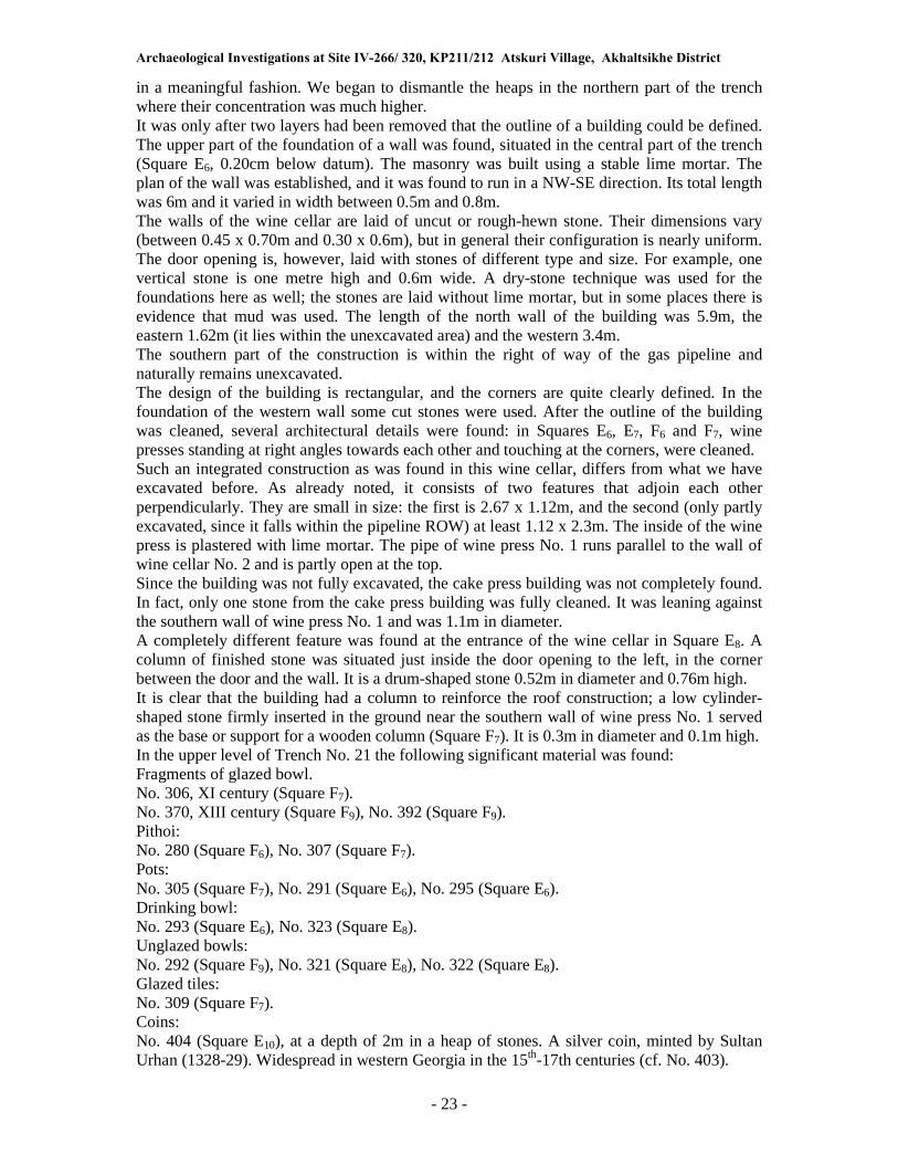
Archaeological Investigations at Site IV-266/ 320, KP211/212 Atskuri Village, Akhaltsikhe District
- 23 -
in a meaningful fashion. We began to dismantle the heaps in the northern part of the trench where their concentration was much higher. It was only after two layers had been removed that the outline of a building could be defined. The upper part of the foundation of a wall was found, situated in the central part of the trench (Square E6, 0.20cm below datum). The masonry was built using a stable lime mortar. The plan of the wall was established, and it was found to run in a NW-SE direction. Its total length was 6m and it varied in width between 0.5m and 0.8m. The walls of the wine cellar are laid of uncut or rough-hewn stone. Their dimensions vary (between 0.45 x 0.70m and 0.30 x 0.6m), but in general their configuration is nearly uniform. The door opening is, however, laid with stones of different type and size. For example, one vertical stone is one metre high and 0.6m wide. A dry-stone technique was used for the foundations here as well; the stones are laid without lime mortar, but in some places there is evidence that mud was used. The length of the north wall of the building was 5.9m, the eastern 1.62m (it lies within the unexcavated area) and the western 3.4m. The southern part of the construction is within the right of way of the gas pipeline and naturally remains unexcavated. The design of the building is rectangular, and the corners are quite clearly defined. In the foundation of the western wall some cut stones were used. After the outline of the building was cleaned, several architectural details were found: in Squares E6, E7, F6 and F7, wine presses standing at right angles towards each other and touching at the corners, were cleaned. Such an integrated construction as was found in this wine cellar, differs from what we have excavated before. As already noted, it consists of two features that adjoin each other perpendicularly. They are small in size: the first is 2.67 x 1.12m, and the second (only partly excavated, since it falls within the pipeline ROW) at least 1.12 x 2.3m. The inside of the wine press is plastered with lime mortar. The pipe of wine press No. 1 runs parallel to the wall of wine cellar No. 2 and is partly open at the top. Since the building was not fully excavated, the cake press building was not completely found. In fact, only one stone from the cake press building was fully cleaned. It was leaning against the southern wall of wine press No. 1 and was 1.1m in diameter. A completely different feature was found at the entrance of the wine cellar in Square E8. A column of finished stone was situated just inside the door opening to the left, in the corner between the door and the wall. It is a drum-shaped stone 0.52m in diameter and 0.76m high. It is clear that the building had a column to reinforce the roof construction; a low cylinder-shaped stone firmly inserted in the ground near the southern wall of wine press No. 1 served as the base or support for a wooden column (Square F7). It is 0.3m in diameter and 0.1m high. In the upper level of Trench No. 21 the following significant material was found: Fragments of glazed bowl. No. 306, XI century (Square F7). No. 370, XIII century (Square F9), No. 392 (Square F9). Pithoi: No. 280 (Square F6), No. 307 (Square F7). Pots: No. 305 (Square F7), No. 291 (Square E6), No. 295 (Square E6). Drinking bowl: No. 293 (Square E6), No. 323 (Square E8). Unglazed bowls: No. 292 (Square F9), No. 321 (Square E8), No. 322 (Square E8). Glazed tiles: No. 309 (Square F7). Coins: No. 404 (Square E10), at a depth of 2m in a heap of stones. A silver coin, minted by Sultan Urhan (1328-29). Widespread in western Georgia in the 15th-17th centuries (cf. No. 403).

Archaeological Investigations at Site IV-266/ 320, KP211/212 Atskuri Village, Akhaltsikhe District
- 24 -
No. 405, a copper coin, discovered in the same place, with no date. According to numismatists, it was minted between 1014 and 1075 AH (AD 1605/6-1664/65) (cf. Pakhomov, 1928: pp. 91-92). Obv. a beast with claws, extended muzzle, sharp ears (worn). Rev. Farsi inscription, worn, no date preserved. Only one coin of this type of coins was known hitherto (Kapanadze, 1969: pp. 149-150). In the lower level of Trench No. 21 the following significant material was found: Pithoi: No. 282 (Square F8), No. 316 (Square E8), Nos. 360/361(Square F1). Unglazed bowls: No. 290 (Square E5), No. 298 (Square E10), No. 312 (Square E8), at the door of the wine cellar, at floor level, No. 337 (Square E8), the same location, No. 320 (Square F6), Nos. 325/324 (Square F9), Nos. 326/327 (Square F6). Glazed bowls: No. 303 (Square F9), No. 328 (Square F8), No. 331 (Square F6), saltcellar, No. 351 (Square E10). Buff coloured cups: No. 285 (Square F5), No. 286 (Square F1), No. 315 (Square E10), No. 318 (Square F1), No. 330 (Square F8). Glazed tiles: No. 299 (Square E10). Fragment of oven: No. 357 (Square F9). The period in which the wine cellar found in Trench No. 21 was active was the 15th-16th centuries, a conclusion arrived at on the basis of the date of the majority of the finds, especially the coins. With regard to a Persian coin of the 18th century (No. 405), its date has not been finally established and it cannot therefore be decisive in this case. It would, moreover, be a complicated business to move the most of the finds from the floor of the wine press into the 17th century. It is possible that this later coin was intrusive and reached the area of Trench No. 21 by accident. 5.3 Artefacts
The rich and varied archaeological material found at Atskuri in the year under consideration may be dated to the High and later Middle Ages. The following categories can be distinguished by material: Ceramics:
A total of 346 items, mostly fragmentary, may be divided into the following types: 1) glazed bowls, Group 1 (56 items); 2) glazed bowls, Group 2 (66 items); 3) jars (3 items); 4) (37 items); 5) plates (1 item); 6) drinking bowls (18 items); 7) jugs (9 items); 8) saltcellars (3 items); 9) faience pottery fragments (7 items); 10) thin-walled buff-fired cups (20 items); 11) pithoi (40 items); 12) pot lids (56 items); 13) torches (4 items); 14) tobacco pipes (1 item); 15) basin (1 item); 16) bakery (3 items); 17) spindle (1 item); 18) water pipe (2 items); 19) wine press collecting tanks (1 item); 20) ritual hearth (3 items); 21) frying pan (3 items); 22) glazed tiles (14 items); 23) unglazed tiles (9 items); 24) fragments of unidentified pottery (35 items); 25) bricks (1 item). Of these, the most significant are the glazed bowls, which can be divided into two chronological groups: 1. Bowls, which have white slip designs inside and are glazed in light blue. The fragments of
bowls, glazed in different colors and decorated with drawings of plants should also be included in this group. Similar material from medieval houses in Georgia may be dated to the High Middle Ages (11th-13th centuries). These fragments were mainly found in observation trenches Nos. 3 and 10, in removed earth, and the lower occupation levels of the wine cellars Nos. 2 and 3.

Archaeological Investigations at Site IV-266/ 320, KP211/212 Atskuri Village, Akhaltsikhe District
- 25 -
2. Bowls with a white slip inside and a green glaze outside. Again parallels can be found in material generally dated to the 15th-16th centuries, a dating supported by data derived from the occupation levels of the wine cellars. Most of the wine cellars (Nos. 4, 5, 6 and 7) that we studied in the year under consideration were active in this period.
In shape, ornament and nature of their glaze, the glazed bowls find parallels in pottery produced in Medieval Georgia (e.g. Tbilisi, Rustavi, Dmanisi, Zhinvali). The same may be said of the kitchenware (pots, jars, frying pans) and building materials (bricks, tiles) and other ceramic products. It is also significant that among the groups of buff-coloured cups and tiles High and Late medieval production can also be distinguished. For example, cups with extremely thin walls and handles and a highly polished surface should be dated to the High Medieval. These items are very similar to cups produced in Tbilisi, Dmanisi and especially Rustavi in the 12th-13th centuries. By contrast, among the Atskuri material we also have a one-handled buff-coloured cup (No. 169), which with its thick bottom and disproportionate shape is clearly different from the first group. Some of them were discovered on the floor of one of the 15th-16th century wine cellars (No. 4), which is why their Late Medieval classification is beyond question.. Particularly interesting is the collecting tank from wine cellar No. 6. At first glance it recalls a normal ovoid pithos with relief decoration. Here, however, the ornament is totally different, and the rim is turned upwards and outwards. It is a remarkable thing to say, but one cannot recall ever having seen such a pithos or a collecting tank in the Georgian ceramic repertoire (and its local origin is beyond question). The closest parallels for this highly unusual item (and in particular its neck and rim) are to be found in large scale Georgian pottery of the Bronze Age. In view of the great distance in time, it is difficult to speak of a tradition, but the similarity is nevertheless worth noting.. We would like to note separately some small fragments of high-quality faience. Although they are few in number, we are reasonably certain that they were exported from Iran, presumably in the 12th-13th centuries.

Archaeological Investigations at Site IV-266/ 320, KP211/212 Atskuri Village, Akhaltsikhe District
- 26 -
Glass
Among the glass items we have some small fragments of cups and parts of bracelets that presumably can be dated to the 13th-14th centuries. The bracelets are clearly locally produced, a fact that can be attested by reference to numerous parallels from other Medieval sites in Georgia. Finds of glassware dating to the 13th century have also been made near the village of Natbeuri, where similar bracelets were produced. Metal
The most significant items among the iron finds are nails and horseshoes, which are characteristic for settlements in Medieval Georgia. We note separately the fragmentary iron objects which occurred across the site in many levels. It is clear that these items migrated from the upper slopes and they suggest that there may once have been an iron workshop up there. Numismatic material is mentioned separately. The coins that were discovered are of great help to us in establishing the chronology of both sites and artefacts. The discovery of a copper coin (No. 409) dating to the second half of the 12th century in the upper level of Trench No. 9 presumably comes from earlier occupation levels that had been destroyed when the wine presses were built; the same is probably the case with glazed tiles and the St. George plaque. The second coin dates to ca. 1300 (No. 407). It was found in the north-eastern corner of wine cellar No. 5, at the level of the foundation of the wall. This suggests that the this wine cellar was constructed in the early XIV century. The discovery of Turkish coins of the 17th centuries (Nos. 405-406) in wine cellars Nos. 6 and 7 is also significant, since this strongly implies that they were still active at a later period.
Stone
The brown sandstone triangular plaque with a cross in relief is especially noteworthy. On each side of the cross there are early Georgian inscriptions also in relief (�Tsminda� and
�Giorgi�: �Saint George�). The epigrapher Giorgi Gagoshidze kindly informs us that
paleographically this image belongs to the 10th century. It was found in Trench No. 9, on the stone step outside the wine cellar and opposite the hearth. It is obvious that this image precedes the activity of wine cellar No. 5 (15th century?) and that the plaque migrated here much later from the upper part of the slope. Here we must also mention the fragments of glazed tiles, which show up at the same level and are presumably of the same origin as the St. George plate. In this context, we had earlier been alerted to the likelihood that the hill behind wine cellar No. 5 concealed a significant building. If we take into consideration the fact that the glazed tiles clearly date to the 11th-12th centuries and that such tiles were principally used for covering church domes, our assumption that there was a church of the period up the hill would seem to be well founded.
Interpretation
The archaeological excavations conducted at KP211 and KP212 of the pipeline have provided us with some highly important and comprehensive material for the study of the medieval history of a part of ancient Georgia, of Samtskhe. The excavated wine cellars with their wine and cake presses clearly reveal the important role that viticulture played in the activities of the people of the region. These wine cellars also constitute important architectural sites of the people of the Middle Ages. It is noteworthy that both wine cellars and wine presses are typologically similar to those found at contemporary sites excavated in other parts of Georgia (Kakheti, Kartli, Aragvi Gorge) (Ramishvili, 1974; Rcheulishvili, 1990; Chilashvili, 1975). It is also significant that no pithoi for wine fermentation or storage were found in these wine cellars. We assume that our structures were located in vineyards, away from residential areas, and that they were only used for wine-pressing. The juice was immediately taken to wine cellars near people�s houses. This

Archaeological Investigations at Site IV-266/ 320, KP211/212 Atskuri Village, Akhaltsikhe District
- 27 -
hypothetical picture finds parallels in the ethnography of the medieval period and of the beginning of the last century in Aragvi Gorge (Nanobashvili, 1960; Songhulashvili, 1974). Attention should also be paid to the term �wine-press� used in conjunction with the term
�wine-cellar� in Georgian written sources (Nikortsmindis datserili) (Berdzenishvili, 1979). Apparently our ancestors distinguished the �wine-cellar�, where they kept pithoi for storing
wine, from �wine-press�, which was actually a wine press and cake press, meant for the
primary treatment of grapes. For this reason, it might be worth creating the term �wine-press-
cellar� in the scientific literature. The discovery of a ritual corner with small oven and hearth in the wine cellar found in Trench No. 9 is highly significant. This is unquestionably evidence for the existence of pagan, pre-Christian, cult rituals in the Middle Ages. Similar kinds of evidence were found in the excavations of a house in Zhinvali (Rcheulishvili, 1990). The rich and varied finds of ceramic material find parallels in excavated material from elsewhere in Georgia (Japaridze, 1956; Mitsishvili, 1967), but there are some local peculiarities that should not be overlooked. For example, in this region both glazed and unglazed ceramics were produced for domestic, industrial and building purposes. It is also worth drawing attention to the great number of iron objects that must also be evidence for the development of viticulture, although we could not find any remains of iron foundries. Presumably, these workshops were located higher up the slope, near the village of Tkemlana, whence our material will have migrated. Even after a preliminary study of the excavated sites and finds we confidently state that we have a complex of artefacts that embody a substantial amount of valuable information, and which provides a firm foundation for the study of the economy, culture and daily life of the population of medieval Samtskhe. In particular, we have obtained totally new information about viticulture in Ancient Georgia. There also important botanical insights. The Atskuri excavations provided the earliest evidence for olive, walnut, and hazelnut in Georgia. The discovery of remains of olives is the most important of these, since it indicates a radical degree of climatic change. Other evidence for a much warmer climate having prevailed in the 15th-16th centuries is the presence of oak, lime, oleaster, sea-buckthorn, alder buckthorn and oriental hornbeam. We should also take note of the fact that it has been established by means of paleobotanical analysis that the grape pips found in the Late Medieval wine cellar No. 7 either belong to a group of primitive species, or else did not enjoy especially good standards of husbandry (e.g. with regard to weeding). This is an important detail that is somehow appropriate in the context of what is emerging as an extraordinarily complicated period in Georgia�s history. 6.0 Conclusions and Recommendations
The wine cellars that we have studied in the neighborhood of the village of Atskuri provide a good insight into industrial activity in Medieval Samtskhe. Of special interest is the fact that within this small area there were concentrated eight wine cellars, a figure which is quite impressive. Judging by the building, it is clear that different kinds of grapes, both red and white, were pressed in these wine cellars. These wine cellars do not, however, represent the kind of buildings in which people used to store the grape juice. This would explain the universal absence of storage pithoi. The only type of vessel discovered here are kitchenware and table pottery, or to be more precise, small jugs and bowls. Thanks to interdisciplinary research it was established that in these wine cellars people used to press in the main varieties of grapes that are currently not used for wine making. Most of them belong to species with small berries, parallels for which are preserved today in rudimentary and wild form only within the area of Samtskhe. It is also interesting that among the grains rye was also to be found here.

Archaeological Investigations at Site IV-266/ 320, KP211/212 Atskuri Village, Akhaltsikhe District
- 28 -
In terms of territorial organization, it is interesting to note the existence of stone fencing and irrigation systems, the headworks for which were presumably located in the neighbourhood of Tisli village. With regard to economic relationships, it is also interesting that we found coins near the wine cellars, something that perhaps reflects the very moments when transactions relating to wine took place in vineyards and wine cellars. In short, the excavations conducted in the area of Atskuri have provided us with completely fresh material relating to viticulture in Samtskhe between the 10th and 17th centuries. Recommendations
I. In the light of recommendations made by the Atskuri Archaeological Expedition, the wine cellars found in Trenches No. 12 and No. 5 were conserved; and the pipeline route was slightly altered at KP212.
II. During construction at KP212+900 a complete wine cellar was destroyed (photos that provide evidence of this unfortunate fact are filed with the Department of New Constructions at the Otar Lordkipanidze Institute of Archaeology). It is not simply necessary, but obligatory, to carry out compensatory excavations of this wine cellar, since: 1) There was an agreement with BP management to this effect and the agreement should be carried out; 2) each wine cellar has its own special scientific importance and if situations like this are overlooked, there is a grave danger that scholarly information will be lost.
III. The concentration of buildings at KP 211 and KP 212 strongly suggest that to either side of the pipeline corridor there must be many archaeological remains. If therefore any further works of any kind or on any scale are envisaged, it should be a requirement to carry out archaeological investigations.
IV. The architectural diversity of the sites found (their design, interior organization, and function) is of such great importance�as is the need for their preservation, and the fresh insights they have produced�that it is absolutely necessary to publish them fully in both Georgian and English.

Archaeological Investigations at Site IV-266/ 320, KP211/212 Atskuri Village, Akhaltsikhe District
- 29 -
7.0 References Cited
Batonishvili, V. 1973, Aghtsera sameposa saqartvelosi, qartlis tskhovreba (Description of the Kingdom of Georgia, History of Georgia), Volume I, Tbilisi. Beridze, V. 1970, Samtskhes khurotmodzghvruli dzeglebi (Architectural Monuments of Samtskhe), Tbilisi. Berdzenishvili, M. 1979, Metertmete saukunis qartuli saistorio tskaroebi (Georgian Historical Sources of the Eleventh Century), Tbilisi. Gegechkori, A. 1979, Chveni tkeebis binadrebi (Inhabitants of Our Forests), Tbilisi. Dundua, G. 1964, Samoneto mimoktsevis sakitkhisatvis XV saukunis saqartveloshi (About Monetary Turnover in the Georgia of the XV Century), Tbilisi. Ekvtimishvili, Z. 1946, Kavkasiis iremi borjomis sakhelmtsipo nakrdzalshi (Caucasian Deer
in the Borjomi State Reservation), Tbilisi. Kavkasiis geologia (Geology of the Caucasus), 1933, Prof. Al. Janelidzis lektsiebis mikhedvit
shedgenili konspeqti (Synopsis Based on the Lectures of Prof. Alexander Janelidze) Kapanadze, D. 1969, Qartuli numizmatika (Georgian Numismatics), Tbilisi. Licheli, V. 2001, Kolkhetisa da iberiis kulturis sakitkhebi (Issues of Culture of Kolkheti and Iberia), Tbilisi. Lomtatidze, G. 1977, Saqartvelos mosakhleobis kultura da kopa XI-XIII saukuneebshi (Culture and Life of the Population of Georgia in the XI-XIII centuries),Tbilisi. Lomtatidze, G. 1955, Arqeologiuri gatkhra tbilisshi 1948 tslis zamtarshi (Archaeological Excavations in Tbilisi in the Winter of 1948), Tbilisi. Lomtatidze, G. 1974, Shuapeodaluri khanis namosakhlarebis gatkhra samshvildis
midamoebshi (Excavations of Dwellings of the Middle Feudal Age in the Neighbourhoods of Samshvilde), Volume I, Tbilisi. Lomouri, T. 1948, Davit VII da Vakhtang III pulebi, cc XV-B (Coins of David VII and Vakhtang) III, XV-B. Maruashvili, L. 1964, Saqartvelos pizikuri geograpia (Physical Geography of Georgia), �Tsodna�, Tbilisi. Maruashvili, L. 1969, Saqartvelos pizikuri geograpia (Physical Geography of Georgia), Volume I, Tbilisi State University Publishing, Tbilisi. Masalebi saqartvelos faunisatvis (Materials on the Fauna of Georgia), Section VI, Metsniereba, Tbilisi. Mitsishvili, M. 1967, Mochikuli churcheli dzvel saqartveloshi (Glazed Pottery in Ancient Georgia), Tbilisi.

Archaeological Investigations at Site IV-266/ 320, KP211/212 Atskuri Village, Akhaltsikhe District
- 30 -
Nanobashvili, I. 1969, Vazis dzveli kultura qizikshi (Ancient Viticulture in Kizikhi), Tbilisi. Petriashvili, R. 1975, Meskhetis niadagebi (Soils of Meskheti), Publishing House �Sabchota
saqartvelo�, Tbilisi. Ramishvili, R. 1970, Ivris kheobis arqeologiuri dzeglebi (Archaeological Sites of Iori Gorge), Sioni, Tbilisi. Ramishvili, R. 1974, Iaghsris namosakhlari da mlasheebis goris marani (Iaghsari Dwelling and Mlasheebis Gora Wine Cellar), Volume II, Tbilisi. Rcheulishvili, G. 1990, Pshavis aragvis kheobis arqeologiuri dzeglebi (Archaeological Sites of Pshavi Aragvi Gorge), Tbilisi. Rcheulishvili, G. 1975, Arqeologiuri kvleva-dzieba khertvisis koshktan (Archaeological Investigation at the Khertvisi Fortress), Collection �Zhinvalis Eqspeditsia�, Tbilisi. Rcheulishvili, G. 1981, Devebianasa da didruvis nasoflarebi (Dwellings of Devebiana and Didruvi), Collection �Zhinvalis Eqspeditsia�, Tbilisi. Rcheulishvili, G. 1977, Aragvis kheobis satsnakhelebi (Wine Presses of Aragvi Gorge), Collection �Arqeologiuri Dziebani�, Tbilisi. Sabashvili, M. 1965, Saqartvelos SSR niadagebi (Soils of the SSR of Georgia), Metsniereba, Tbilisi. Saqartvelos tskhovelta samkaro (Animals in Georgia), Metsniereba, Volume I, Tbilisi, 1965, Volume II, Tbilisi, 1964, Volume III, Tbilisi, 1973. Songhulashvili, J. 1974, Saqartvelos mevenakheoba-meghvineobis istgoriisatvis (On the History of Georgian Viticulture), Tbilisi. Sumbadze, L. 1968, Saqartvelos marnis khurotmodzghvreba (Architecture of Georgian Wine Cellar), �Daeglis Megobari�, Tbilisi. Kartlis Tskhovreba (History of Georgia), 1955, Volume I, Tbilisi. Kartlis Tskhovreba (History of Georgia), 1959, Volume II, Tbilisi. Ghambarashvili, N., Burjanadze, V. 1966, Saqartvelos nadir-prinveli (Animals and Birds in Georgia), �Nakaduli�, Tbilisi. Ghambarashvili, N., Janashvili, A. 1972, Zoologia Zoology, Tbilisi. 1. Chkhatarashvili, M., 1964, �Rustavis shuasaukuneta mouchiqavi keramikis erti sakheoba�
One Type of Unglazed Ceramic Pottery in Rustavi of Medieval Age, �Matsne�, No. 1,
Tbilisi. 2. Chkhatarashvili, M., 1969, �Shua saukuneebis rustavshi minis tsarmoebis istoriisatvis� On
the History of Glass Production in Rustavi of Medieval Age, Volume I, Tbilisi. 3. Dzvelaia, M., 1975, �Etiudebi saqartvelos geologiuri tsarsulidan� Sketches from the
Geological Past of Georgia, Publishing House of the Academy of Sciences of Georgia, Tbilisi, 1962.
4. Chilashvili, L., �Dzveli Gavazi� The Ancient Black Kite, Tbilisi. 5. Javakhishvili, Al., 1926, �Saqartvelos geografia� Geography of Georgia, Volume I,
�Geomorfologia� Geomorphology, Edition of the Tbilisi University, Tiflis.

Archaeological Investigations at Site IV-266/ 320, KP211/212 Atskuri Village, Akhaltsikhe District
- 31 -
6. Janashvili, A., 1950, �Mgeli da aptari� Wolf and Hyena, �Sakhelgami�, Tbilisi. 7. Janashvili, A., 1950, �Jikhvi� Caucasian Goat, �Sakhelgami�, Tbilisi. 8. Janashvili, A., 1977, �Sakartvelos chlikosnebi� Hoofed Mammals in Georgia, �Sabchota
saqartvelo�, Tbilisi. 9. Janashvili, A., 1963, �Sakartvelos tskhovelta samkaro� Fauna of Georgia, Volume III,
�Kherkhemlianebi� Vertebrates, Tbilisi. 10. Janashvili, A., 1950, �Machvi da kverna� Badger and Marten, �Sakhelgami�, Tbilisi. 11. Janashvili, A., 1958, �Saqartvelos faunis gardaqmna� Transformation of the Georgian
Fauna, Tbilisi. 12. Janashvili, A., 1974, �Zoogeografia� Zoogeography, Tbilisi. 13. Japaridzse, V., 1956, �Qartuli keramika (XI-XIII ss)� Georgian Ceramics (XI-XIII
centuries), Tbilisi. 14. Jalaghania, N.L., 1958, History of Coinage in Georgia of the XIII Century, Tbilisi. 15. Pakhomov, E.A., 1928, Weight and Value of a Copper Coin of Tiflis in XVII-XVIII
centuries, �Vostokovedenie�, Volume III, Publishing House �Vostok� of the Asian
Department, Baku University, Baku. 16. Pakhomov, E.A., 1910, Coins of Georgia. 17. The Enyclopaedia of Islam v. I. L-L. 1955 18. Schrotter F. 1930, Worterbuch der Münzkunde B-L. Licheli V., 1999, St. Andrew in
Samtskhe: archaeological proof? In: Ancient Christianity in the Caucasus. Iberica Caucasica. Vol. 1. London.
19. Licheli V., 1999, Une ville des VIIe�Ier siècles. In: Religions du Pont-Euxin, Paris. 20. Licheli V., 1999, The Black Sea � Vani � Samtskhe: the Spreading Route of Black-glazed
Pottery. In: La Mer noire Zone de Contacts. Paris. Appendix A
Metal Artefact Analysis Report
Eight metal artefacts were restored: 1. Iron object (function uncertain) No. 1-100; 2. Iron object (function uncertain) No. 1-101; 3. Bronze object (function uncertain) No. 3-316; 4. Bronze object ((function uncertain)) No. 4-340; 5. Bronze buckle No. 5-339; 6. Bronze coin No. 4-404; 7. Lead finger ring No. 7-407; 8. Bronze ring No. 8-400. The chemical composition of two artefacts was determined by means of spectral analysis (Table 1). 1. Buckle No. 5-339. Chemical composition: (Cu-87.0; Sn-0.45; Zn-0.8). Copper with
admixtures. 2. Finger ring No. 7-407. Chemical composition (Pb-96.0; Cu-1.5; Sn-1.3). Made of lead
alloy (Photo 1). Restoration scheme for bronze materials
Prior to restoration each object underwent macro-structural morphological investigation and photofixation (Photo 2).

Archaeological Investigations at Site IV-266/ 320, KP211/212 Atskuri Village, Akhaltsikhe District
- 32 -
Bronze artefacts were treated mechanically by means of a scalpel and other sharp tools. Mechanical cleaning was conducted beneath a microscope under conditions of intense light. Cleaned objects were processed with acetone, and then the surface of dried objects was covered with Paraloid B 72, polymer of thermoplastic acryl, Paraloid B 72 + Acetone (40 g + 1.5 l)], (Photo 3). Restoration scheme for iron materials
The iron items were treated mechanically, by means of a dental drill, using diamond and steel brushes. The mechanically cleaned items were treated with a complex compound of tannin + spirit + orthophosphoric acid, and at the second stage only a tannin spirit solution was used (the process was repeated several times). For conservation the item was covered with thermoplastic acrylic polymer Paraloid B 72 (Paraloid B 72 + Acetone 40g + 1,5l).
Results of the spectral analysis
Table 1
N Laboratory
Code Item
Discovery
site Cu Sn Pb Zn Bi Ag Sb As Fe Ni Co Au
1 U-705 Bronze buckle N 339 87.0 0.45 0.35 0.8 0.005 0.08 0.08 0.03
2 U-706 Lead Ring
N 407 1.5 1.3 96.0 0.16 0.023 0.014
Appendix B
Palaeoethnobotanical Analysis Report
By Nana Rusishvili, N. Meladze
In order to find fossil botanical material we studied soil samples from different levels of the Atskuri site. Eight samples were studied from a palaeo-ethnobotanical viewpoint. Botanical material was found in six samples. In order to find botanical material, the soil samples were treated by the flotation method, which means �washing� the soil with water and CCL4. After this, the resulting material was
divided into fractions by means of separation sieves of different diameters, then it was dried, reinforced and conserved and prepared for identification. The botanical material that we found represents fruit and seeds of fossil plants. The identification of botanical material was carried out by means of a stereoscopic microscope down to familia and species according to the complex of morphological peculiarities (Dobrokhotov 1961; Kats, Kipiani.1965; Rollov 1908; Latalova 1999). As a result of research on the material eight species of cultivated plants and weeds were found. Wheat, rye and grapes were identified (Table No1). Among the archaeobotanical material, wheat is represented by round, small, grains. The apical and ventral sides of the grain are equally wide, and the ventral furrow is deep. The dorsal side is rounded. The proportion of width of the grain to its length (L/B) varies within 1.3-1.6 mm (Table 2). Taken together, these features allow to us attribute the carbonized wheat grains to Triticum aestivo-compactum Schiemann. Such identification is admissible in palaeo-ethnobotanics when it is difficult make a clear distinction between soft and compact wheats. Rye, or Secale cereale ssp. segetale Zhuk., was recorded among the palaeo-ethnobotanical material in quantities equal with wheat. The grains have a large base and an obtuse apical

Archaeological Investigations at Site IV-266/ 320, KP211/212 Atskuri Village, Akhaltsikhe District
- 33 -
part, while the ventral side is furrowed. Table 3 presents the parameters and indexes of the grains. Such a high presence of weeds in the wheat-sown areas can be explained by the location of these areas on the northern slope, where the plants are not directly exposed to the sun and the wheat remains suspended for a long time, and rye, which grows among the wheat as a weed, becomes dominant and occupies a larger area of the field. Due to the lower temperature wheat cannot compete with rye (Hillman 1978, pp. 157-174). Grapes were found in two samples (Table 1). In both cases the fossil seeds (Fig. XVI) were found in soil samples taken in Wine Cellar No. 7. The grape seeds were badly damaged, which is why the calculation of parameters was only possible for a small part (Tables 3-4). According to morphological features, the seeds are small in size: length (L) varies within 3.5-5mm, width (B) within 2-3.5mm, and the length of the beak within 0.7-1mm; the proportion L/B is equal to 0.7-1 (Negrul, 1960, pp. 111-119). The seeds are pear-shaped, the ventral juncture is not visible, and the side valleculae are mainly parallel. According to Negrul�s
correlational curve, small seeds lead to small fruit. Therefore, the seeds found in the Wine Cellar either belong to a primitive species or were not subject to proper agrotechnical treatment (weeding, etc.).
Weeds and wild plants
1. Agrostemma githaro L. Corn cockle. Familia of cloves (Caryophyllaceae). Seed parameters 2.5 x 2 x 1.5mm. A weed. Retains the capability to grow for several years. After harvesting, corn cockle does not spread in the soil, it mixes with the seed material and leads to its intense growth among grains. The seeds contain toxic glucoside agrostemine. Under high pressure glucoside breaks up and the seeds lose their toxicity.
2. Galium spurium L. Catchweed. Familia: Rubiaceae. Seed parameters 1.5 x 1 x 1.25mm. It is known as a lint weed. Is rarely encountered among grains.
3. Galium tricorne Stokes. Corn badstraw. Familia: Rubiaceae. The diameter of the seed is 2-2.5mm. Grows mainly among grains.
4. Setaria viridis L. Green bristlegrass. Familia: Graminae (grains). Seed parameters 1.0 x 0.8mm. It is a weed, growing among grains or at the edge of roads.
5. Solanium nigrum L. Morel. Familia: Solanaceae. Seed parameters 1.5-2 x 1.25-1.5 x 0.5-0.7mm. Morel is known as a weed, it grows at the edges of the roads, near houses, on dumps, river banks. The plant contains the narcotic substance solanine. In the past a small quantity of the fruit was given to children to get rid of intestinal problems.
Thus, as a result of the investigation of palaeo-ethnobotanical material we had a good basis for the reconstruction of the agrocoenosis of the building. We may assume that crop farming in the area was not very successful at the time of occupation. It is possible, however, that this was only a local phenomenon, which did not apply to the whole region. Description of Atskuri Table 1:
1. Wine cellar No. 7, wine press No.2, 1.8m. 1. Vitis sp.
2. Solanium nigrum L. 2. Wine cellar No. 7, a jar with a handle burnt in black, 1.8m
1. Vitis sp.
2. Galium tricorne
3. Setaria viridis
3. Wine cellar No. 7, at the north-western wall of the press. 1. Triticum aestivo-compactum
2. Secale cereale ssp. Segetale
3. Galium spurium
4. Agrostemma githago
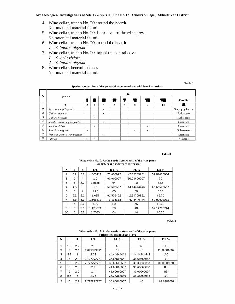
Archaeological Investigations at Site IV-266/ 320, KP211/212 Atskuri Village, Akhaltsikhe District
- 34 -
4. Wine cellar, trench No. 20 around the hearth. No botanical material found.
5. Wine cellar, trench No. 20, floor level of the wine press. No botanical material found.
6. Wine cellar, trench No. 20 around the hearth. 1. Solanium nigrum
7. Wine cellar, trench No. 20, top of the central cove. 1. Setaria viridis 2. Solanium nigrum
8. Wine cellar, beneath plaster. No botanical material found.
Table 1
Species composition of the palaeoethnobotanical material found at Atskuri
N Species Site
Familia I II III IV V VI VII VIII
1 2 3 4 5 6 7 8 9 10 11
0 Agrostema githago L. . x Garyophyllaceae 2 Galium spurium x Rubiaceae 3 Galium tricorne x Rubiaceae 4 Secale cereale ssp segetale x Graminae 5 Setaria viridis x x Graminae 6 Solanium nigrum x x x Solanaceae 7 Triticum aestivo-compactum x Graminae 8 Vitis sp x x Vitaceae
Table 2
Wine-cellar No. 7. At the north-western wall of the wine press
Parameters and indexes of soft wheat
N L B L/B B/L % T/L % T/B %
1 5.2 3.8 1.368421 73.076923 42.30769231 57.89473684
2 6 4 1.5 66.666667 36.66666667 55
3 5 3.2 1.5625 64 40 62.5
4 4.5 3 1.5 66.666667 44.44444444 66.66666667
5 5 4 1.25 80 50 62.5
6 5.2 3.2 1.625 61.538462 42.30769231 68.75 7 4.5 3.3 1.363636 73.333333 44.44444444 60.60606061
8 4 3.2 1.25 80 45 56.25
9 5 3.5 1.428571 70 40 57.14285714
10 5 3.2 1.5625 64 44 68.75
Table 3
Wine-cellar No. 7. At the north-western wall of the wine press
Parameters and indexes of rye
N L B L/B B/L % T/L % T/B %
1 5.5 2.2 2.5 40 40 100
2 5 2.4 2.083333333 48 44 91.66666667
3 4.5 2 2.25 44.44444444 44.44444444 100
4 6 2.2 2.727272727 36.66666667 36.66666667 100
5 6 2.2 2.727272727 36.66666667 33.33333333 90.90909091
6 6 2.5 2.4 41.66666667 36.66666667 88 7 6 2.5 2.4 41.66666667 36.66666667 88
8 5.5 2 2.75 36.36363636 36.36363636 100
9 6 2.2 2.727272727 36.66666667 40 109.0909091

Archaeological Investigations at Site IV-266/ 320, KP211/212 Atskuri Village, Akhaltsikhe District
- 35 -
10 4.5 2.2 2.045454545 48.88888889 44.44444444 90.90909091
Table 4
Wine-cellar No. 7. Wine press No. 2
Parameters of grapes
N L B Beak length L/B
1 3.5 2.5 0.8 1.4
Table 5
Wine-cellar No. 7. Jar with burnt handle
Parameters of grapes
N L B Beak length L/B
1 4 2.5 0.7 1.6
2 4.5 3.5 0.8 1.285714286
3 3.5 2.2 0.9 1.590909091
References cited
Dobrokhotov, V. N. 1961. Semena sornikh rastenii (Seeds of Weeds), Moscow. Hillman G. 1978. �On the origins of domestic rye - Secale cereale: the finds from aceramic
Can Hasan III in Turkey.� Anatolian Studies 28:157-174. Kats N.Y., Kats, S.V., Kipiani, M.G. 1965. Atlas i opredelitel plodov i semyan vstrecha-
yushchikhsya v chetvertichnykh otlozheniyakh SSSR (Atlas and Determinant of Fruits and Seeds, met with in the Quaternary Deposits of the USSR). Moscow.
Latalova M. 1999. �A palaeoecological reconstruction of environmental conditions and
economy in early medieval Wolin, against the background of the landscape.� Acta
Palaeobotanica, vol. 39/2 Krakow. Negrul, А.М. 1960. �Evilutsija razmera semjan I jagod u vinograda.� (Evolution of the
dimensions of the seeds and berries of grapes). Newsletter of the Technical Agricultural
Academy, 2/33: 111-119. Rollov, A.Kh. 1908. Dikorastushchiye rasteniya Kavkaza, ikh rasprostraneniye, svoistva i
primeneniye (Wild Plants of the Caucasus, their Distribution, Characteristics and Applications).
Appendix C
Pollen Analysis Report
By Eliso Kvavadze
Ten samples were taken in 2005 from the Navenakhari site. Five of them were obtained in the small trench, three in Trench 12, and two from different levels of Trench 16. Palynological material was processed in the Palynological Laboratory of the Institute of Paleobiology. For this purpose the currently established standard methodology was applied: for the first stage

Archaeological Investigations at Site IV-266/ 320, KP211/212 Atskuri Village, Akhaltsikhe District
- 36 -
the material was boiled in potassium alkali, for the second it was centrifugally separated in heavy fluid and for the third the material underwent acetolysis, or in other words, was stained. As a result of laboratory treatment, a sufficient quantity of pollen grains was separated in all the samples. Organic remains of a non-palynological nature such as cloth fibres were also found. Cotton, linen cloth, and thread remains were found as well. There were also coloured fibres in the samples (Pls. XIX, XX). With regard to pollen grains, in each sample of the materials investigated between 250 and 300 pollen grains were counted. In total, the pollen of 65 plants was distinguished, 19 of which belonged to trees and bushes. In the grass group vineyard, orchard and wheat crop weeds are prevalent. Trench No. 9. The samples were taken from the bottom of the wine-press, the bottom of a pithos and from the burnt layer (at depths of 1.82, 1.80, 1.75, 1.70, 0.83m, Table 1). In the scraping from the bottom of wine-press No. 1 (Sample 1), among the tree species, a quantity of grape (Vitis vinifera) pollen grains predominated; 12 pollen grains were found here (Pl. XVII). There were also pollen grains of hazelnut (Corylus) and olive (Olea), which indicates the existence of a horticultural establishment. In the third sample there were also pollen grains of walnuts (Juglans regia). Among the grasses, cultivated grains were distinguished. There were a lot of pollen grains belonging to grain crop and vineyard weeds. These weeds included goosefoot (Chenopodiaceae), knotgrass (Polygonum), succory (Cichorioidae), turnip (Brassica), and buckwheat (Fagopyrum). As regards wild plants, they were represented mainly by forest elements. These were spruce (Picea), pine (Pinus), hornbeam (Carpinus), and oak (Quercus). There are fewer pollen grains of shrubs, but they included ephedra (Ephedra), sea-buckthorn (Hippophae), and hazel (Corylus). There were also ferns (Pl. XVIII) such as staghorn fern (Pteris cretica) and spleenwort (Asplenium). Almost the same set of pollen grains were found in the rest of the samples taken in Trench No. 9. There were plenty of grape pollen grains, and also olive, but the trees are better represented here. Pollen grains of species such as lime (Tilia), chestnut (Castanea sativa), alder (Alnus), oriental hornbeam (Caprinus orientalis), oleaster (Elaeagnus), and gaiter-tree (Thelycrania). (Table 1).
Trench 12. Three samples were taken here and studied. The sample No. 6 was taken at the NE wall of the first building of the trench under discussion, at a depth of 1.9m. A cone was also found here. The second sample was taken at the hearth of the wine cellar, at a depth of 1.88m (Sample No. 7). Sample No. 8 was taken in the southern corner of the trench at a depth of 2m and it represents remains of the wall. The first two samples were rich in pollen grains, but there was little material in the third sample. As in Trench No. 9, there were pollen grains of cultivated grapes, wheat, olive, hazelnut and other indicators of crop farming. Vineyards and wheat crop weeds were also well represented. For example, there were many elements of knotgrass, bindweed and buckwheat pollen. There are also elements of range lands, as well as the kind of weeds that grow near houses, such as nettle (Urtica), burdock (Xantium), or sorrel (Rumex). As regards wild plants, there were many pollen grains of pine (Pinus) (Fig. XVII). The second dominant variety was spruce (Picea), and the third ephedra (Ephedra). We also found pollen grains of fir (Abies), alder (Alnus), chestnut (Castanea), sea-buckthorn (Hippophae) and hazelnut (Corylus), as well as spores of forest fern and moss. Trench No. 16. Here, in a pit, fenced by stones, we extracted two samples and studied them. The palynological complex is similar to the material discussed above. The pollen of cultivated plants such as grapes, wheat, olive, walnut, hazelnut, was well represented here. In the group of weeds crop farming elements prevailed. There were also grazing and ruderal elements. The pollen of wild plants was mainly represented by forest elements. There were plenty of pine (Pinus) and ephedra (Ephedra) pollen grains. Hornbeam (Carpinus caucasica), alder (Alnus), elm (Ulmus) were strongly represented. There were fewer pollen grains of oak (Quercus),

Archaeological Investigations at Site IV-266/ 320, KP211/212 Atskuri Village, Akhaltsikhe District
- 37 -
lime (Tilia), alder buckthorn (Ostrya), sea-buckthorn (Hippophae) and birch (Betula). Rock brake (Polypodium vulgare), moonwort (Botrychium), cretic pteris (Pteris cretica) and adder�s tongue (Ophioglossum vulgatum) were to be found among the group of ferns. The palynological complex that we found demonstrates that the end of the 13th century, as well as the next three centuries, were characterized by ecological conditions totally different from today. The existence of species such as oak, lime, oleaster, sea-buckthorn in the forest provides evidence for the fact that by comparison with today, the climate was much warmer. Further evidence for a warm climate was provided by the discovery of spores of various species of ferns. At present all the above-mentioned plants grow in the lower belt of forests and do not grow higher than 700m (Ketskhoveli, 1971). Atskuri is located at an altitude of 960m. This warm climate favoured the strong development of viticulture. It should be noted that the revival of viticulture in the 13th century also took place in England (Utterstrom, 1955). The cultivation of the olive in Atskuri would not have been possible without a warm climate. According to palynological data, the olive was cultivated in Georgia since antiquity (Connor, Kvavadze, 2005). Plantations of olives imported from Greece grew in western, southern and eastern parts of Georgia (Ketskhoveli, 1959). But the anomalous fall in temperature at the end of the 17th century destroyed viticulture, and not only in Atskuri. This fall in temperature was short and global. In 1675-1715 these climatic conditions covered the whole Europe (Le Roy Ladurie, 1971; Kvavadze, Rukhadze, 1989; Frenzel, 1995; Kvavadze, et al. 2007). At this time viticulture was totally destroyed in England and Germany (Le Roy Ladurie, 1971, 13-14). During this period there was no wheat yield in northern Europe and the prices for wheat dramatically increased in southern Europe (Le Roy Ladurie, 1971, 13-14). In this period the area of ice in the mountains of the Caucasus expanded and many of the glaciers started moving towards the lowlands (Gobejishvili, 1989). The temperature fell over the whole territory of Georgia. For example, judging by the palynological data, during the fall in temperature we have been discussing, the neighbourhood of Lisi Lake was covered with spruce forest (Kvavadze, 1999). The upper belt of the forest moved down from the mountains in both eastern and western Georgia. Olive and grapes were finally wiped out in Atskuri. Subsequent production of these two crops was not possible on a wide scale.
References Cited
Connor S.V., Kvavadze E.V. 2005. �Climatic and human influences on vegetation dynamics
around Tbilisi over the past 6000 years�. Proceedings of the Georgian Academy of Sciences. Biological series B, 3, No.4, 64-76. Frenzel B (ed.). 1994. �Climatic trends and anomalies in Europe 1675-1715�. Special Issue
ESF Project European Palaeoclimate and Man 8, vol.13, Gustav Fischer Verlag. Stuttgart, Jena, New York.
Gobejishvili, R.G., 1989. Ledniki Gruzii (Glaciers of Georgia). Metsniereba, Tbilisi.
Ketskhoveli, N., 1959. Sakartvelos mtsenareuli sapari (The Growth of Georgia). Academy of Sciences of the Georgian SSR, Tbilisi. Ketskhoveli, N., 1971. Sakartvelos flora (Georgian Flora), 1. Metsniereba, Tbilisi.
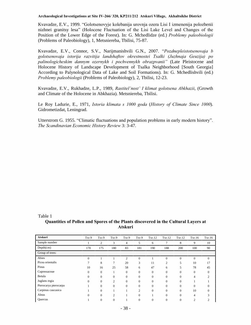
Archaeological Investigations at Site IV-266/ 320, KP211/212 Atskuri Village, Akhaltsikhe District
- 38 -
Kvavadze, E.V., 1999. �Golotsenovyje kolebanija urovnja ozera Lisi I izmenenija polozhenii nizhnei granitsy lesa� (Holocene Fluctuation of the Lisi Lake Level and Changes of the
Position of the Lower Edge of the Forest). In: G. Mchedlidze (ed.) Problemy paleobiologii (Problems of Paleobiology), 1, Metsniereba, Tbilisi, 75-87. Kvavadze, E.V., Connor, S.V., Narijmanishvili G.N., 2007. �Pozdnepleistotsenovaja b
golotsenovaja istorija razvitija landshaftov okrestnostei Tsalki (Juzhnaja Geuzija) po
palinologicheskim dannym ozernykh i pochvennykh obrazpvanii� (Late Pleistocene and Holocene History of Landscape Development of Tsalka Neighborhood [South Georgia] According to Palynological Data of Lake and Soil Formations). In: G. Mchedlishvili (ed.) Problemy paleobiologii (Problems of Paleobiology), 2, Tbilisi, 12-23. Kvavadze, E.V., Rukhadze, L.P., 1989, Rastitel�nost� I klimat golotsena Abkhazii, (Growth and Climate of the Holocene in Abkhazia). Metsniereba, Tbilisi. Le Roy Ladurie, E., 1971, Istoria klimata s 1000 goda (History of Climate Since 1000). Gidrometizdat, Leningrad. Utterstrom G. 1955. �Climatic fluctuations and population problems in early modern history�.
The Scandinavian Economic History Review 3: 3-47.
Table 1 Quantities of Pollen and Spores of the Plants discovered in the Cultural Layers at
Atskuri
Atskuri Txr.9 Txr.9 Txr.9 Txr.9 Txr.9 Txr.12 Txr.12 Txr.12 Txr.16 Txr.16
Sample number 1 2 3 4 5 6 7 8 9 10
Depth(cm) 170 175 180 83 181 190 188 200 100 90
Group of trees:
Abies 0 1 1 2 0 1 0 0 0 0 Picea orientalis 7 8 7 20 3 11 2 5 10 17 Pinus 10 16 25 58 6 47 6 5 78 45 Cupressaceae 0 0 1 0 0 0 0 0 0 0 Betula 0 0 0 0 0 0 0 0 4 2 Juglans regia 0 0 2 0 0 0 0 0 1 1 Pterocarya pterocarpa 1 0 0 0 0 0 0 0 0 0 Carpinus caucasica 1 0 1 1 2 0 0 0 10 0 Alnus 0 0 2 1 0 1 0 0 4 3 Quercus 1 0 0 1 0 0 0 0 2 2

Archaeological Investigations at Site IV-266/ 320, KP211/212 Atskuri Village, Akhaltsikhe District
- 39 -
Tilia 0 0 0 0 0 0 0 0 0 2 Castanea sativa 0 0 2 2 0 1 0 0 0 0 Ulmus 0 0 0 0 0 0 0 0 5 2 Rosaceae 1 0 0 0 0 0 0 0 0 2
Corylus 3 1 0 1 0 2 1 0 2 4 Hippophae 1 0 0 0 0 2 0 0 0 1 Olea europaea 3 4 6 0 0 0 5 0 1 3 Elaeagnus 0 5 0 0 0 0 0 0 0 0 Thelycrania type 0 0 3 3 0 0 0 0 0 0 Ephedra 5 0 2 0 1 4 1 0 18 3
Vitis vinifera 12 4 4 2 2 0 8 0 5 1
Sum: 45 39 56 91 14 69 23 10 140 88
Herbaceous group:
Poaceae 2 2 8 5 0 4 2 0 6 3 Triticum 0 0 0 0 0 3 0 0 1 0 Cerealia 2 0 0 3 0 3 0 0 2 1 Chenopodiaceae 10 29 46 82 7 6 0 3 26 4 Chenopodium album 0 0 0 0 0 1 0 0 0 0 Artemisia 1 0 0 0 0 9 0 0 0 1 Artemisia annua type 0 0 0 3 0 9 17 0 3 0 Aster type 3 0 5 9 2 3 3 5 1 2 Achillea 0 0 0 0 0 9 0 0 3 0 Cichorioidae 32 11 9 22 5 19 18 4 17 11 Carduus 0 0 0 0 0 9 1 0 2 1 Cirsium 0 0 1 0 0 9 0 0 1 0 Serratula 0 0 2 0 0 4 0 0 2 0 Xanthium 0 0 0 0 0 1 0 0 0 0 Fagopyrum 7 2 1 0 0 3 2 0 0 2 Polygonum type 12 8 9 25 0 8 6 3 11 6 Polygonum aviculare 1 0 0 1 0 9 0 0 1 0 Rumex 0 0 0 0 0 2 0 0 0 3 Convolvulus 0 0 0 0 0 2 0 0 2 0 Ranunculus 0 0 2 0 0 0 0 0 2 0 Linum maritimum 0 0 0 0 0 0 0 0 0 1 Primula 0 0 0 0 0 0 0 0 0 1 Apiaceae 4 0 7 6 0 7 3 0 11 3 Caryophyllaceae 0 0 3 4 1 2 0 3 0 2 Saxifragaceae 0 0 2 4 0 0 0 0 6 8 Boraginaceae 0 0 8 7 0 2 0 0 0 0 Epilobium 0 0 2 0 0 4 0 0 0 0 Plantago m/m 0 0 0 0 0 0 0 0 1 1 Plantago lanceolata 0 0 0 1 0 0 0 0 2 0 Helianthemum 1 0 0 0 0 0 0 0 0 0 Rosaceae 0 0 0 0 0 3 0 0 7 0 Myriophyllum 0 0 0 0 0 1 0 0 0 0 Fabaceae 0 0 0 0 0 0 0 0 12 3 Trifolium 0 0 2 2 0 0 0 0 0 0 Lamiaceae 3 0 0 5 0 3 0 0 6 8 Brassicaceae 4 5 0 0 2 4 4 0 3 6 Sphagnum 0 0 0 0 0 0 0 0 0 1 Bothrychium lunaria 0 0 0 1 0 0 0 0 1 0 Polypodiaceae 9 2 0 3 0 0 2 0 12 3 Polypodium vulgare 0 0 0 0 0 0 0 0 0 1 Polypodium serratum 0 0 0 0 0 0 0 0 3 0 Cryptogramma crispa 0 0 0 0 0 1 0 0 0 0 Pteris cretica 7 0 0 0 0 0 1 0 4 2 Indeterminate NAP 11 4 10 11 3 13 4 2 13 12
Sum: 109 63 117 194 20 153 63 20 161 86
Sum of palynomorphs: 154 102 173 285 34 222 86 30 301 174

Archaeological Investigations at Site IV-266/ 320, KP211/212 Atskuri Village, Akhaltsikhe District
- 40 -
Appendix D
Paleozoological Analysis Report
By Oleg Bendukidze
There was a distinct predominance of domestic animals among the osteological material from Atskuri. These included remains of domestic cattle, domestic pig, horse, donkey, buffalo and poultry. The only wild animal bones were those of deer and the jaw and isolated teeth of a field mouse. There were clearly two breeds of cattle at Atskuri, large and small, easily defined by the different sizes of their bones. The bones of the Atskuri pig, judging by the size and morphology of its bones, does not differ from the aboriginal Black Kakhetian Pig. According to N. Burchak-Abramovich, this black pig must be associated with the South Asian region (the Sus vitattus group). The Atskuri horse appeared to be quite a large animal, but the absence of teeth in the material available for study did not allow for more a precise definition. As regards the remains of the domestic donkey, they are not unusual in Georgia. E.g., donkey remains are abundantly represented in the Mtskheta archeological material (information from D. Burchak). The discovery of buffalo bones is of a certain interest (metatarsal, phalanxes of the extremities, hooves). This material was identified by the shape of metatarsal distal condyles, shortness of the II phalanxes and length of the hooves. It should be noted that buffalo remains have not hitherto been found in Georgia previously, but according to N. Burchak-Abramovich buffalo bones are frequently encountered in Azerbaijan. Another item of special interest among the Atskuri osteological material is a fragment from the upper jaw of a small dog, which appears to have a short rostrum. This jaw has obvious signs of having oblique premolars. In particular, the back of the third upper premolar is directed towards the incisor slightly laterally. It is an established fact (Bendukidze, 2001) that such oblique location of premolars in dogs is normally an indication of a short rostrum. We can thus assume that in this case we are dealing with a �boxer� or �bulldog� breed of
dog.

Archaeological Investigations at Site IV-266/ 320, KP211/212 Atskuri Village, Akhaltsikhe District
- 41 -
PLATES

Archaeological Investigations at Site IV-266/ 320, KP211/212 Atskuri Village, Akhaltsikhe District
- 42 -

Archaeological Investigations at Site IV-266/ 320, KP211/212 Atskuri Village, Akhaltsikhe District
- 43 -

Archaeological Investigations at Site IV-266/ 320, KP211/212 Atskuri Village, Akhaltsikhe District
- 44 -
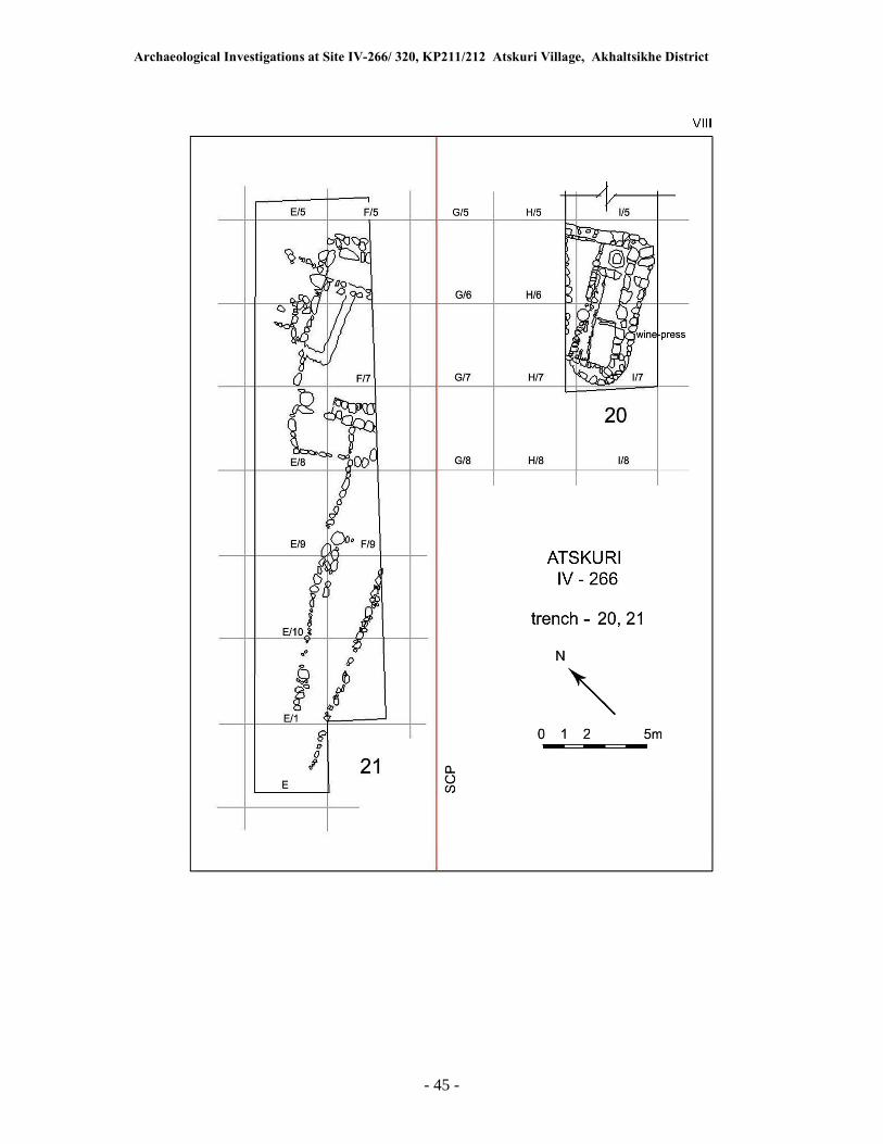
Archaeological Investigations at Site IV-266/ 320, KP211/212 Atskuri Village, Akhaltsikhe District
- 45 -

Archaeological Investigations at Site IV-266/ 320, KP211/212 Atskuri Village, Akhaltsikhe District
- 46 -

Archaeological Investigations at Site IV-266/ 320, KP211/212 Atskuri Village, Akhaltsikhe District
- 47 -

Archaeological Investigations at Site IV-266/ 320, KP211/212 Atskuri Village, Akhaltsikhe District
- 48 -

Archaeological Investigations at Site IV-266/ 320, KP211/212 Atskuri Village, Akhaltsikhe District
- 49 -

Archaeological Investigations at Site IV-266/ 320, KP211/212 Atskuri Village, Akhaltsikhe District
- 50 -

Archaeological Investigations at Site IV-266/ 320, KP211/212 Atskuri Village, Akhaltsikhe District
- 51 -

Archaeological Investigations at Site IV-266/ 320, KP211/212 Atskuri Village, Akhaltsikhe District
- 52 -

Archaeological Investigations at Site IV-266/ 320, KP211/212 Atskuri Village, Akhaltsikhe District
- 53 -

Archaeological Investigations at Site IV-266/ 320, KP211/212 Atskuri Village, Akhaltsikhe District
- 54 -

Archaeological Investigations at Site IV-266/ 320, KP211/212 Atskuri Village, Akhaltsikhe District
- 55 -

Archaeological Investigations at Site IV-266/ 320, KP211/212 Atskuri Village, Akhaltsikhe District
- 56 -
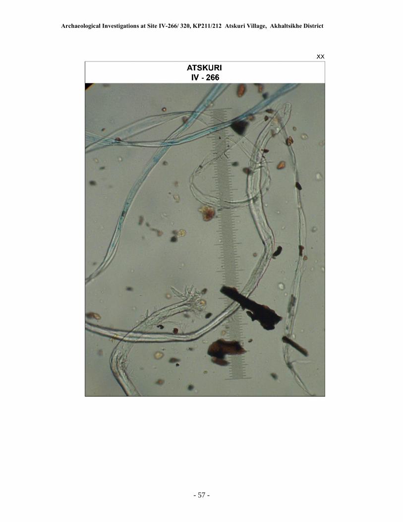
Archaeological Investigations at Site IV-266/ 320, KP211/212 Atskuri Village, Akhaltsikhe District
- 57 -