Embed Size (px)
Citation preview
124 London Archaeologist Summer 2003
Introduction
Pre-Construct Archaeology Ltd was
commissioned by CgMs Consulting on behalf of
their clients, The Peabody Trust, to undertake
archaeological investigations at 30-36 Upper
Clapton Road, London E5, in advance of a
proposed building development. An evaluation in
March 2000 was followed the next month by a
rescue excavation comprising one large L-shaped
trench (Fig. 1).
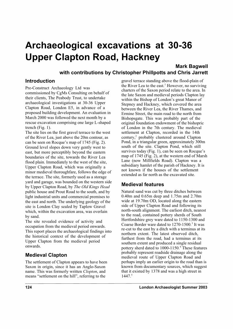
The site lies on the first gravel terrace to the west
of the River Lea, just above the 20m contour, as
can be seen on Rocque’s map of 1745 (Fig. 2).
Ground level slopes down very gently west to
east, but more perceptibly beyond the eastern
boundaries of the site, towards the River Lea
flood plain. Immediately to the west of the site,
Upper Clapton Road, which was originally a
minor medieval thoroughfare, follows the edge of
the terrace. The site, formerly used as a storage
yard and garage, was bounded on the western side
by Upper Clapton Road, by The Old Kings Head
public house and Prout Road to the south, and by
light industrial units and commercial premises to
the east and north. The underlying geology of the
site is London Clay sealed by Taplow Gravel
which, within the excavation area, was overlain
by sand.
The site revealed evidence of activity and
occupation from the medieval period onwards.
This report places the archaeological findings into
the historical context of the development of
Upper Clapton from the medieval period
onwards.
Medieval Clapton
The settlement of Clapton appears to have been Saxon in origin, since it has an Anglo-Saxon name. This was formerly written Clopton, and means “settlement on the hill”, referring to the
gravel terrace standing above the flood-plain of
the River Lea to the east.1 However, no surviving charters of the Saxon period relate to the area. In the late Saxon and medieval periods Clapton lay within the Bishop of London’s great Manor of Stepney and Hackney, which covered the area between the River Lea, the River Thames, and Ermine Street, the main road to the north from Bishopsgate. This was probably part of the original foundation endowment of the bishopric of London in the 7th century. The medieval settlement at Clapton, recorded in the 14th
century,2 probably clustered around Clapton Pond, in a triangular green, approximately 300m south of the site. Clapton Pond, which still survives today (Fig. 1), can be seen on Rocque’s map of 1745 (Fig. 2), at the western end of Marsh Lane (now Millfields Road). Clapton was a subsidiary hamlet of the parish of Hackney. It is not known if the houses of the settlement extended as far north as the excavated site.
Medieval features
Natural sand was cut by three ditches between 0.40m and 0.65m deep and 1.75m and 2.70m wide at 19.70m OD, located along the eastern side of Upper Clapton Road and following its north-south alignment. The earliest ditch, nearest to the road, contained pottery sherds of South Hertfordshire grey ware dated to 1150-1300 and
Coarse Border ware dated to 1270-1500.3 It was re-cut to the east by a ditch with a terminus at its northern extent. The latest observed ditch, furthest from the road, had a terminus at its southern extent and produced a single residual
pottery sherd dated to 1000-1150.4 These features probably represent roadside drainage along the medieval route of Upper Clapton Road and perhaps imply an earlier origin to the road than is known from documentary sources, which suggest that it existed by 1378 and was a high street in
1447.5
Archaeological excavations at 30-36
Upper Clapton Road, HackneyMark Bagwell
with contributions by Christopher Phillpotts and Chris Jarrett
London Archaeologist Summer 2003 125
The ditches were sealed by a silty sand medieval plough soil deposit up to 0.40m thick which covered much of the site. It contained small numbers of pottery sherds of London-type ware dated to 1080-1350 and Kingston ware dated to 1230-1400. They probably derived from manuring activities in ploughed cultivation strips. The absence of other features, except a gully near the road, suggests the site may have been part of one of the open fields of Clapton called Mill Field; the original name of Lea Bridge Road was Mill Field Lane. This name is preserved today as Millfields Road, formerly Marsh Lane (Fig. 2), and as North and South Millfields, open (recreation) ground on either side of Lea Bridge Road just 200m east of the site.
The medieval pottery was largely derived from local sources provided by the London-type wares, and the more distant Kingston ware and Surrey/Hampshire coarse border ware. Most were from cooking pots, many with sooted external surfaces indicative of domestic activity. Some may have derived from a settlement in the vicinity, presumably Clapton, as early as the 11th to mid-12th centuries.
Development in the 16th and 17th
centuries
The site lay at the northern limit of the village of Clapton, which in the early decades of the 16th century became one of the series of villages around London that was used as a commuter belt by Henry VIII’s courtiers. A large brick residence, on the opposite side of Upper Clapton road from the excavated site, was built around two courtyards possibly as early as 1476, but is only certainly known from 1532, when it belonged to the Earl of Northumberland and lay within the manor of Hackney Lordshold. In January 1535 Northumberland sold the house to the king, and it became known as King’s Place. A few months later, Henry VIII granted it to Thomas Cromwell who subsequently surrendered it back to the king in 1536. The Earl of Northumberland was living there again in 1537. In the 17th century the house passed through the hands of various gentry families, and became known as Brooke House. It ceased to be an
aristocratic residence in 1677.6 Following bomb Fig. 1: site/trench location
126 London Archaeologist Summer 2003
damage in the Second World War, the remains of Brooke House were excavated and recorded by
W. F. Grimes in 1955-56.7
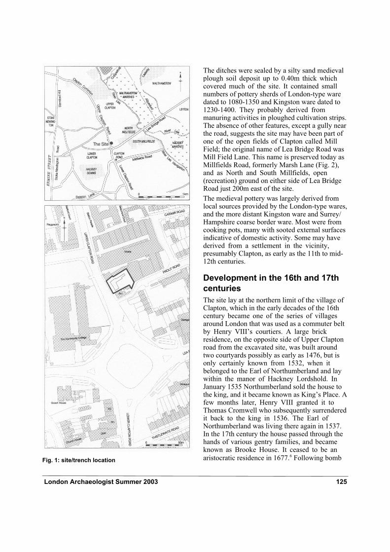
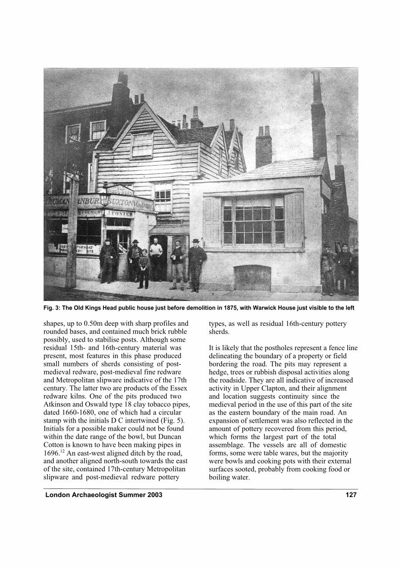
The Old King’s Head public house, adjacent to the site’s southern boundary, was probably erected in about the 1660s. Its name is thought to have referred to the memory of King Charles I, who was executed in 1649, but to have been built after the restoration of his son Charles II in 1660. Charles I’s portrait was built into the coloured
tiling of the wall of the lobby.8 Benjamin Clarke thought it was probably the oldest public house in
Clapton.9 The old rat-infested clapboard structure (Fig. 3), as one observer called it, was demolished
and rebuilt in brick in 1875.10 No remains of the 17th-century building were visible above ground at the time of excavation.
The 16th- and 17th-century features
and timber-framed building
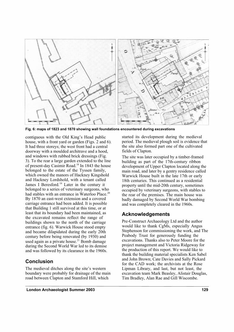
A 16th- or 17th-century rectangular building, represented by a wall foundation one brick wide, was recorded in the north-west of the site. It was
set back 8m from and parallel to the present main road (Building 1, Fig. 4). Its dimensions were 4.30m east-west by 3.20m north-south, continuing north beyond the limit of excavation. The wall was constructed to a height of 0.58m at 20.85m OD, of five courses of stretchers with a single course of headers set on edge at its base. The wall, set within a narrow construction trench, would have formed the foundations for a timber
framed building.11 Tiles in situ on top of the wall functioned as a plinth, presumably to level it for a timber sill beam and keep it off the ground. None of the building’s floor surfaces survived and there is little evidence for its function or status. Later, probably in the late 17th or early 18th centuries, a 5.10m long north-south aligned wall, one brick wide, was built on top of the structure’s eastern side. This extended southwards and beyond the southern limit of the trench.
Fifteen shallow pits and postholes were excavated, truncating the medieval plough soil at around 20m OD (Fig. 4). Many were located along the site’s western boundary forming a north-south alignment, also having similar
Fig. 2: Rocque’s map of 1745 showing site in relation to the River Lea
London Archaeologist Summer 2003 127
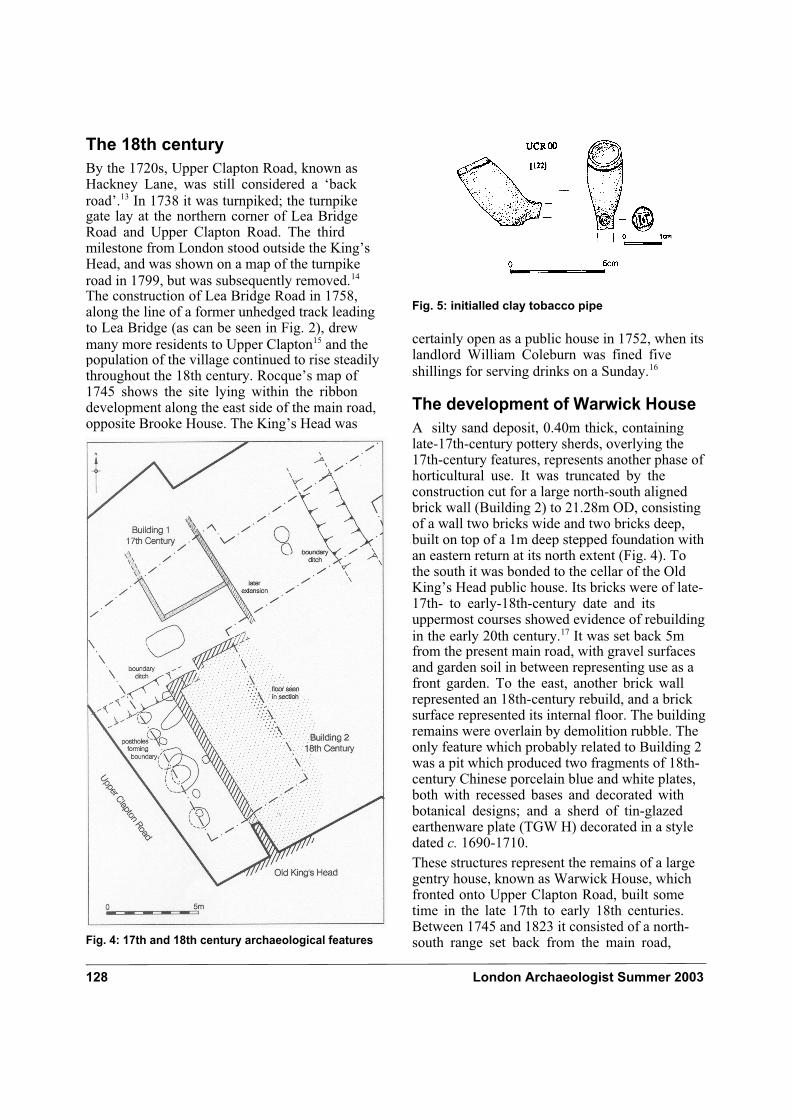
shapes, up to 0.50m deep with sharp profiles and rounded bases, and contained much brick rubble possibly, used to stabilise posts. Although some residual 15th- and 16th-century material was present, most features in this phase produced small numbers of sherds consisting of post-medieval redware, post-medieval fine redware and Metropolitan slipware indicative of the 17th century. The latter two are products of the Essex redware kilns. One of the pits produced two Atkinson and Oswald type 18 clay tobacco pipes, dated 1660-1680, one of which had a circular stamp with the initials D C intertwined (Fig. 5). Initials for a possible maker could not be found within the date range of the bowl, but Duncan Cotton is known to have been making pipes in
1696.12 An east-west aligned ditch by the road, and another aligned north-south towards the east of the site, contained 17th-century Metropolitan slipware and post-medieval redware pottery
types, as well as residual 16th-century pottery sherds.
It is likely that the postholes represent a fence line delineating the boundary of a property or field bordering the road. The pits may represent a hedge, trees or rubbish disposal activities along the roadside. They are all indicative of increased activity in Upper Clapton, and their alignment and location suggests continuity since the medieval period in the use of this part of the site as the eastern boundary of the main road. An expansion of settlement was also reflected in the amount of pottery recovered from this period, which forms the largest part of the total assemblage. The vessels are all of domestic forms, some were table wares, but the majority were bowls and cooking pots with their external surfaces sooted, probably from cooking food or boiling water.
Fig. 3: The Old Kings Head public house just before demolition in 1875, with Warwick House just visible to the left
128 London Archaeologist Summer 2003
The 18th century
By the 1720s, Upper Clapton Road, known as Hackney Lane, was still considered a ‘back
road’.13 In 1738 it was turnpiked; the turnpike gate lay at the northern corner of Lea Bridge Road and Upper Clapton Road. The third milestone from London stood outside the King’s Head, and was shown on a map of the turnpike
road in 1799, but was subsequently removed.14 The construction of Lea Bridge Road in 1758, along the line of a former unhedged track leading to Lea Bridge (as can be seen in Fig. 2), drew
many more residents to Upper Clapton15 and the population of the village continued to rise steadily throughout the 18th century. Rocque’s map of 1745 shows the site lying within the ribbon development along the east side of the main road, opposite Brooke House. The King’s Head was
certainly open as a public house in 1752, when its landlord William Coleburn was fined five
shillings for serving drinks on a Sunday.16
The development of Warwick House
A silty sand deposit, 0.40m thick, containing late-17th-century pottery sherds, overlying the 17th-century features, represents another phase of horticultural use. It was truncated by the construction cut for a large north-south aligned brick wall (Building 2) to 21.28m OD, consisting of a wall two bricks wide and two bricks deep, built on top of a 1m deep stepped foundation with an eastern return at its north extent (Fig. 4). To the south it was bonded to the cellar of the Old King’s Head public house. Its bricks were of late-17th- to early-18th-century date and its uppermost courses showed evidence of rebuilding
in the early 20th century.17 It was set back 5m from the present main road, with gravel surfaces and garden soil in between representing use as a front garden. To the east, another brick wall represented an 18th-century rebuild, and a brick surface represented its internal floor. The building remains were overlain by demolition rubble. The only feature which probably related to Building 2 was a pit which produced two fragments of 18th-century Chinese porcelain blue and white plates, both with recessed bases and decorated with botanical designs; and a sherd of tin-glazed earthenware plate (TGW H) decorated in a style dated c. 1690-1710.
These structures represent the remains of a large gentry house, known as Warwick House, which fronted onto Upper Clapton Road, built some time in the late 17th to early 18th centuries. Between 1745 and 1823 it consisted of a north-south range set back from the main road, Fig. 4: 17th and 18th century archaeological features
Fig. 5: initialled clay tobacco pipe
London Archaeologist Summer 2003 129
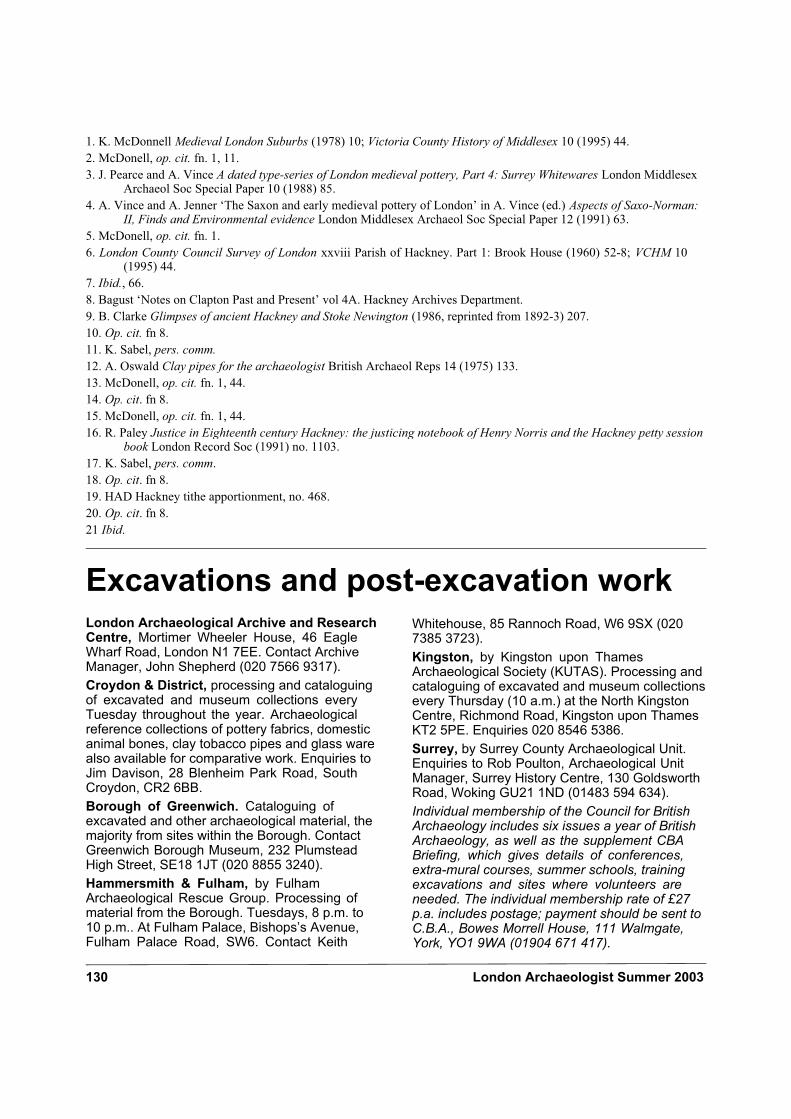
contiguous with the Old King’s Head public house, with a front yard or garden (Figs. 2 and 6). It had three storeys; the west front had a central doorway with a moulded architrave and a hood, and windows with rubbed brick dressings (Fig. 3). To the rear a large garden extended to the line
of present-day Casimir Road.18 In 1843 the house belonged to the estate of the Tyssen family, which owned the manors of Hackney Kingshold and Hackney Lordshold, with a tenant called
James I Beresford.19 Later in the century it belonged to a series of veterinary surgeons, who
had stables with an entrance in Waterloo Place.20 By 1870 an east-west extension and a covered carriage entrance had been added. It is possible that Building 1 still survived at this time, or at least that its boundary had been maintained, as the excavated remains reflect the range of buildings shown to the north of the carriage entrance (fig. 6). Warwick House stood empty and became dilapidated during the early 20th century before being renovated (by 1930) and
used again as a private house.21 Bomb damage during the Second World War led to its demise and was followed by its clearance in the 1960s.
Conclusion
The medieval ditches along the site’s western boundary were probably for drainage of the main road between Clapton and Stamford Hill, which
started its development during the medieval period. The medieval plough soil is evidence that the site also formed part one of the cultivated fields of Clapton.
The site was later occupied by a timber-framed building as part of the 17th-century ribbon development of Upper Clapton located along the main road, and later by a gentry residence called Warwick House built in the late 17th or early 18th centuries. This continued as a residential property until the mid-20th century, sometimes occupied by veterinary surgeons, with stables to the rear of the premises. The main house was badly damaged by Second World War bombing and was completely cleared in the 1960s.
Acknowledgements
Pre-Construct Archaeology Ltd and the author would like to thank CgMs, especially Angus Stephenson for commissioning the work, and The Peabody Trust for generously funding the excavations. Thanks also to Peter Moore for the project management and Victoria Ridgeway for the production of this report. We would like to thank the building material specialists Ken Sabel and John Brown; Cate Davies and Sally Pickard for the CAD work; the archivists at the Rose Lipman Library, and last, but not least, the excavation team Mark Beasley, Alistair Douglas, Tim Bradley, Alan Rae and Gill Wiscombe.
Fig. 6: maps of 1823 and 1870 showing wall foundations encountered during excavations
130 London Archaeologist Summer 2003
1. K. McDonnell Medieval London Suburbs (1978) 10; Victoria County History of Middlesex 10 (1995) 44.
2. McDonell, op. cit. fn. 1, 11.
3. J. Pearce and A. Vince A dated type-series of London medieval pottery, Part 4: Surrey Whitewares London Middlesex Archaeol Soc Special Paper 10 (1988) 85.
4. A. Vince and A. Jenner ‘The Saxon and early medieval pottery of London’ in A. Vince (ed.) Aspects of Saxo-Norman: II, Finds and Environmental evidence London Middlesex Archaeol Soc Special Paper 12 (1991) 63.
5. McDonell, op. cit. fn. 1.
6. London County Council Survey of London xxviii Parish of Hackney. Part 1: Brook House (1960) 52-8; VCHM 10 (1995) 44.
7. Ibid., 66.
8. Bagust ‘Notes on Clapton Past and Present’ vol 4A. Hackney Archives Department.
9. B. Clarke Glimpses of ancient Hackney and Stoke Newington (1986, reprinted from 1892-3) 207.
10. Op. cit. fn 8.
11. K. Sabel, pers. comm.12. A. Oswald Clay pipes for the archaeologist British Archaeol Reps 14 (1975) 133.
13. McDonell, op. cit. fn. 1, 44.
14. Op. cit. fn 8.
15. McDonell, op. cit. fn. 1, 44.
16. R. Paley Justice in Eighteenth century Hackney: the justicing notebook of Henry Norris and the Hackney petty session book London Record Soc (1991) no. 1103.
17. K. Sabel, pers. comm.
18. Op. cit. fn 8.
19. HAD Hackney tithe apportionment, no. 468.
20. Op. cit. fn 8.
21 Ibid.
Excavations and post-excavation workLondon Archaeological Archive and Research Centre, Mortimer Wheeler House, 46 Eagle Wharf Road, London N1 7EE. Contact Archive Manager, John Shepherd (020 7566 9317).
Croydon & District, processing and cataloguing of excavated and museum collections every Tuesday throughout the year. Archaeological reference collections of pottery fabrics, domestic animal bones, clay tobacco pipes and glass ware also available for comparative work. Enquiries to Jim Davison, 28 Blenheim Park Road, South Croydon, CR2 6BB.
Borough of Greenwich. Cataloguing of excavated and other archaeological material, the majority from sites within the Borough. Contact Greenwich Borough Museum, 232 Plumstead High Street, SE18 1JT (020 8855 3240).
Hammersmith & Fulham, by Fulham Archaeological Rescue Group. Processing of material from the Borough. Tuesdays, 8 p.m. to 10 p.m.. At Fulham Palace, Bishops’s Avenue, Fulham Palace Road, SW6. Contact Keith
Whitehouse, 85 Rannoch Road, W6 9SX (020 7385 3723).
Kingston, by Kingston upon Thames Archaeological Society (KUTAS). Processing and cataloguing of excavated and museum collections every Thursday (10 a.m.) at the North Kingston Centre, Richmond Road, Kingston upon Thames KT2 5PE. Enquiries 020 8546 5386.
Surrey, by Surrey County Archaeological Unit. Enquiries to Rob Poulton, Archaeological Unit Manager, Surrey History Centre, 130 Goldsworth Road, Woking GU21 1ND (01483 594 634).
Individual membership of the Council for British Archaeology includes six issues a year of British Archaeology, as well as the supplement CBA Briefing, which gives details of conferences, extra-mural courses, summer schools, training excavations and sites where volunteers are needed. The individual membership rate of £27 p.a. includes postage; payment should be sent to C.B.A., Bowes Morrell House, 111 Walmgate, York, YO1 9WA (01904 671 417).