Embed Size (px)
Citation preview
Spring, 2005 Page 1 LCTA
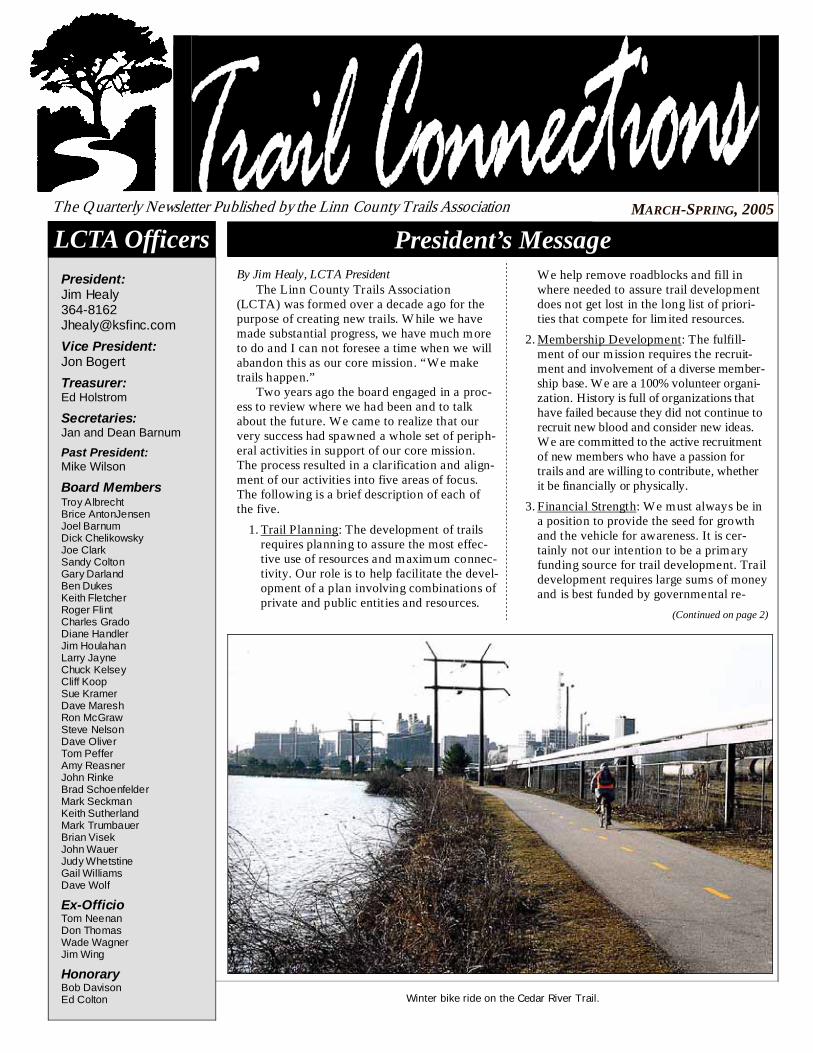
By Jim Healy, LCTA President The Linn County Trails Association (LCTA) was formed over a decade ago for the purpose of creating new trails. While we have made substantial progress, we have much more to do and I can not foresee a time when we will abandon this as our core mission. “We make trails happen.” Two years ago the board engaged in a proc-ess to review where we had been and to talk about the future. We came to realize that our very success had spawned a whole set of periph-eral activities in support of our core mission. The process resulted in a clarification and align-ment of our activities into five areas of focus. The following is a brief description of each of the five.
1. Trail Planning: The development of trails requires planning to assure the most effec-tive use of resources and maximum connec-tivity. Our role is to help facilitate the devel-opment of a plan involving combinations of private and public entities and resources.
President’s Message MARCH-SPRING, 2005 The Quarterly Newsletter Published by the Linn County Trails Association
LCTA Officers President: Jim Healy 364-8162 [email protected]
Vice President: Jon Bogert
Treasurer: Ed Holstrom
Secretaries: Jan and Dean Barnum
Past President: Mike Wilson
Board Members Troy Albrecht Brice AntonJensen Joel Barnum Dick Chelikowsky Joe Clark Sandy Colton Gary Darland Ben Dukes Keith Fletcher Roger Flint Charles Grado Diane Handler Jim Houlahan Larry Jayne Chuck Kelsey Cliff Koop Sue Kramer Dave Maresh Ron McGraw Steve Nelson Dave Oliver Tom Peffer Amy Reasner John Rinke Brad Schoenfelder Mark Seckman Keith Sutherland Mark Trumbauer Brian Visek John Wauer Judy Whetstine Gail Williams Dave Wolf
Ex-Officio Tom Neenan Don Thomas Wade Wagner Jim Wing
Honorary Bob Davison Ed Colton
We help remove roadblocks and fill in where needed to assure trail development does not get lost in the long list of priori-ties that compete for limited resources.
2. Membership Development: The fulfill-ment of our mission requires the recruit-ment and involvement of a diverse member-ship base. We are a 100% volunteer organi-zation. History is full of organizations that have failed because they did not continue to recruit new blood and consider new ideas. We are committed to the active recruitment of new members who have a passion for trails and are willing to contribute, whether it be financially or physically.
3. Financial Strength: We must always be in a position to provide the seed for growth and the vehicle for awareness. It is cer-tainly not our intention to be a primary funding source for trail development. Trail development requires large sums of money and is best funded by governmental re-
(Continued on page 2)
Winter bike ride on the Cedar River Trail.
Linn County Trails Association page 2 www.linncountytrails.org
“President;” (Continued from page 1) sources or grants. However, we are committed to having resources available to assure matching funds are available to maximize grants. We must also be prepared to provide printed materials such as maps and to provide financial support to help expedite a project.
4. Governmental Support: We must foster awareness and commitment at every level of government to assure re-sources are appropriated and effectively allocated for trails. We do not lobby. We are interested in staying informed of the issues at the local, state, and national levels; issues which may create opportunities for trail development and connectivity. By doing so, we are in a position to offer ad-vice and help bring various governmental bodies together to better utilize limited resources or to capitalize on oppor-tunities.
5. Public Awareness and Support: Our mission can only be accomplished when supported by an informed and com-mitted public. In the end, if the public wants trails, they will get them. It is our mission to help those who may not have otherwise recognized the value of trails to see the possibilities and advantages. When they see the value, they will support trails and they will make their wishes known to those who can make it happen. It is our job to get the message out.
You are reading this newsletter so it is a pretty good bet that you are already a member. The more people learn about LCTA, the more they are inclined to get involved. If you share my enthusiasm, please don’t “hide it under a bushel.” Invite your friends to join LCTA. Paying dues is a very significant first step toward the support of our mission. For those who feel inclined, there are opportunities to get involved in one or more of the activities described above. This is a people organization.
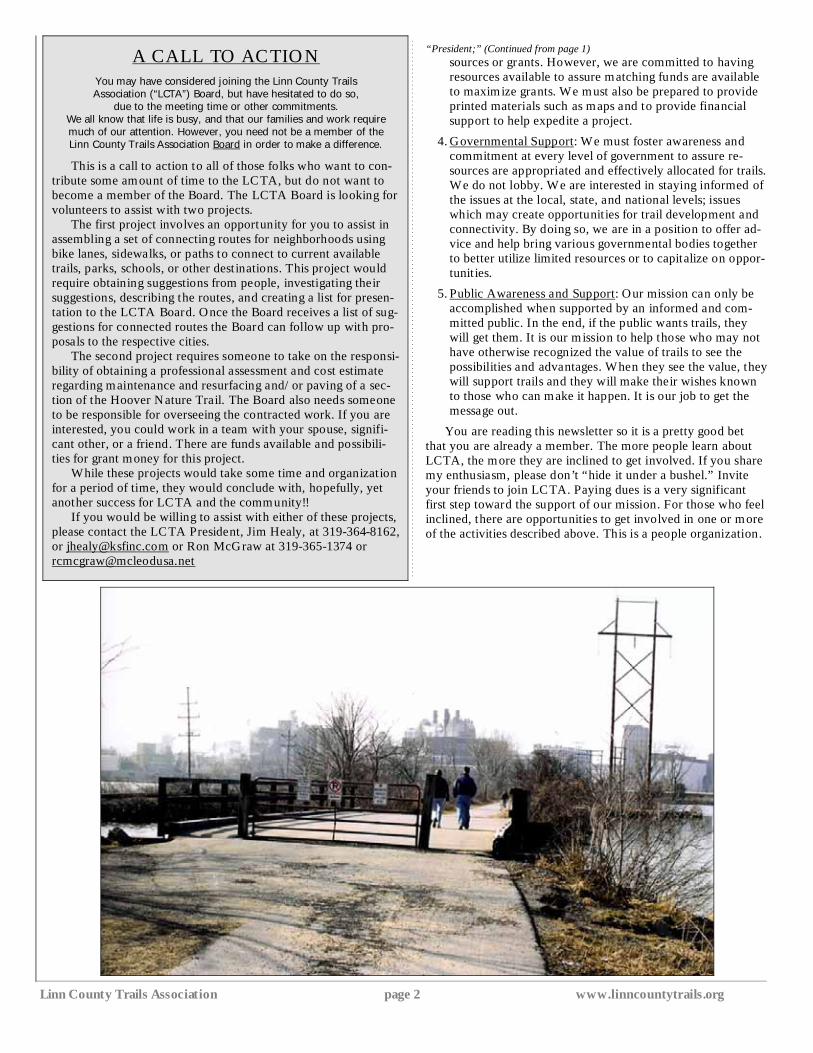
A CALL TO ACTION
You may have considered joining the Linn County Trails Association (“LCTA”) Board, but have hesitated to do so,
due to the meeting time or other commitments.
We all know that life is busy, and that our families and work require much of our attention. However, you need not be a member of the Linn County Trails Association Board in order to make a difference.
This is a call to action to all of those folks who want to con-tribute some amount of time to the LCTA, but do not want to become a member of the Board. The LCTA Board is looking for volunteers to assist with two projects. The first project involves an opportunity for you to assist in assembling a set of connecting routes for neighborhoods using bike lanes, sidewalks, or paths to connect to current available trails, parks, schools, or other destinations. This project would require obtaining suggestions from people, investigating their suggestions, describing the routes, and creating a list for presen-tation to the LCTA Board. Once the Board receives a list of sug-gestions for connected routes the Board can follow up with pro-posals to the respective cities. The second project requires someone to take on the responsi-bility of obtaining a professional assessment and cost estimate regarding maintenance and resurfacing and/or paving of a sec-tion of the Hoover Nature Trail. The Board also needs someone to be responsible for overseeing the contracted work. If you are interested, you could work in a team with your spouse, signifi-cant other, or a friend. There are funds available and possibili-ties for grant money for this project. While these projects would take some time and organization for a period of time, they would conclude with, hopefully, yet another success for LCTA and the community!! If you would be willing to assist with either of these projects, please contact the LCTA President, Jim Healy, at 319-364-8162, or [email protected] or Ron McGraw at 319-365-1374 or [email protected]
Spring, 2005 Page 3 LCTA
Linda Langston, Linn County Supervisor Continuing in our quest to interview public officials, the Trail Connections editorial staff, Jim Wing and Diane Handler, spoke with Linn County Supervisor, Linda Langston. This is Linda's third year as a supervisor and she is currently serving as board chairman.
Linda, please tell us a little bit about yourself. I am a Midwesterner who lived in Mason City, Iowa for my first five years of life, moved to the Chicago area, and ended up in Tulsa, Oklahoma after graduating from Knox College, in Galesburg. I spent summers in Iowa, fishing with my grandfather and playing on my uncle’s farm. I gained a great love for the land and really appreciate being out-doors. I enjoy hiking, horseback riding, and fishing. I have been married to Dave for 30+ years and we have two sons. I have a degree in History and have taught in middle school and high school. I have worked as a psycho-analyst after taking graduate courses in various psychotherapies, and have worked as Director of Development at the Linn County History Center and later as Executive Director.
What do you like the most about your job as supervisor? The days are always different; al-ways new things to learn. What do you like least about your job? The paperwork surrounding all of the bureaucracy, and dealing with peo-
ple who are chronic complainers.
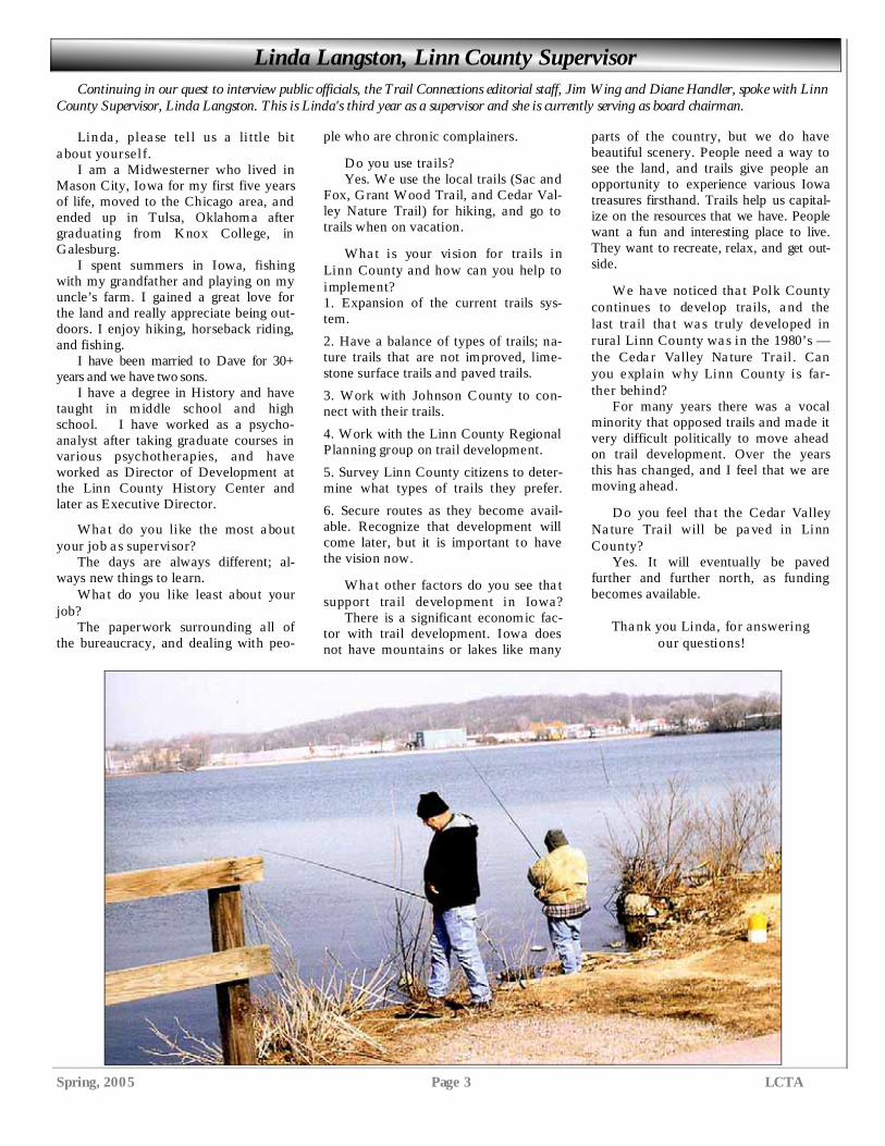
Do you use trails? Yes. We use the local trails (Sac and Fox, Grant Wood Trail, and Cedar Val-ley Nature Trail) for hiking, and go to trails when on vacation.
What is your vision for trails in Linn County and how can you help to implement? 1. Expansion of the current trails sys-tem.
2. Have a balance of types of trails; na-ture trails that are not improved, lime-stone surface trails and paved trails.
3. Work with Johnson County to con-nect with their trails.
4. Work with the Linn County Regional Planning group on trail development.
5. Survey Linn County citizens to deter-mine what types of trails they prefer.
6. Secure routes as they become avail-able. Recognize that development will come later, but it is important to have the vision now.
What other factors do you see that support trail development in Iowa? There is a significant economic fac-tor with trail development. Iowa does not have mountains or lakes like many
parts of the country, but we do have beautiful scenery. People need a way to see the land, and trails give people an opportunity to experience various Iowa treasures firsthand. Trails help us capital-ize on the resources that we have. People want a fun and interesting place to live. They want to recreate, relax, and get out-side.
We have noticed that Polk County continues to develop trails, and the last trail that was truly developed in rural Linn County was in the 1980’s — the Cedar Valley Nature Trail. Can you explain why Linn County is far-ther behind? For many years there was a vocal minority that opposed trails and made it very difficult politically to move ahead on trail development. Over the years this has changed, and I feel that we are moving ahead.
Do you feel that the Cedar Valley Nature Trail will be paved in Linn County? Yes. It will eventually be paved further and further north, as funding becomes available.
Thank you Linda, for answering our questions!
Linn County Trails Association page 4 www.linncountytrails.org
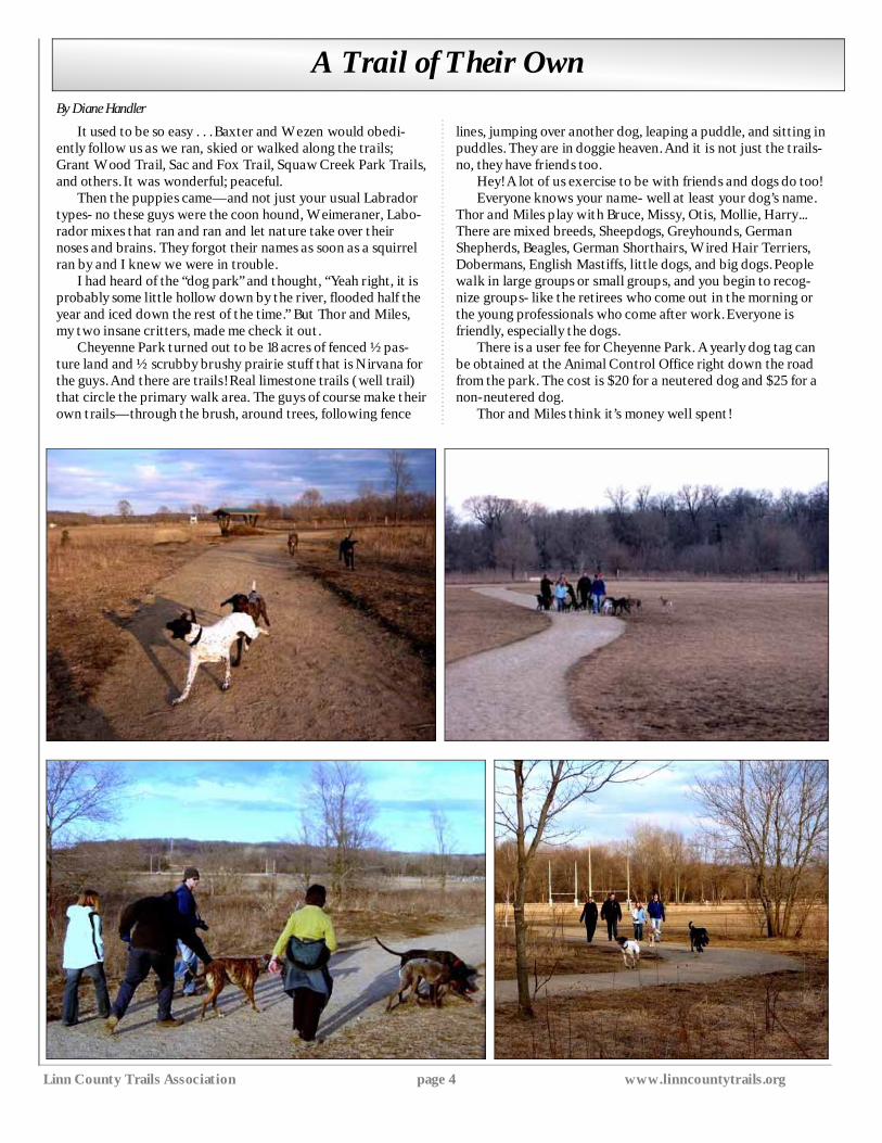
It used to be so easy . . . Baxter and Wezen would obedi-ently follow us as we ran, skied or walked along the trails; Grant Wood Trail, Sac and Fox Trail, Squaw Creek Park Trails, and others. It was wonderful; peaceful.
Then the puppies came—and not just your usual Labrador types- no these guys were the coon hound, Weimeraner, Labo-rador mixes that ran and ran and let nature take over their noses and brains. They forgot their names as soon as a squirrel ran by and I knew we were in trouble.
I had heard of the “dog park” and thought, “Yeah right, it is probably some little hollow down by the river, flooded half the year and iced down the rest of the time.” But Thor and Miles, my two insane critters, made me check it out.
Cheyenne Park turned out to be 18 acres of fenced ½ pas-ture land and ½ scrubby brushy prairie stuff that is Nirvana for the guys. And there are trails! Real limestone trails (well trail) that circle the primary walk area. The guys of course make their own trails—through the brush, around trees, following fence
lines, jumping over another dog, leaping a puddle, and sitting in puddles. They are in doggie heaven. And it is not just the trails- no, they have friends too.
Hey! A lot of us exercise to be with friends and dogs do too! Everyone knows your name- well at least your dog’s name.
Thor and Miles play with Bruce, Missy, Otis, Mollie, Harry... There are mixed breeds, Sheepdogs, Greyhounds, German Shepherds, Beagles, German Shorthairs, Wired Hair Terriers, Dobermans, English Mastiffs, little dogs, and big dogs. People walk in large groups or small groups, and you begin to recog-nize groups- like the retirees who come out in the morning or the young professionals who come after work. Everyone is friendly, especially the dogs.
There is a user fee for Cheyenne Park. A yearly dog tag can be obtained at the Animal Control Office right down the road from the park. The cost is $20 for a neutered dog and $25 for a non-neutered dog.
Thor and Miles think it’s money well spent!
A Trail of Their Own By Diane Handler
Spring, 2005 Page 5 LCTA
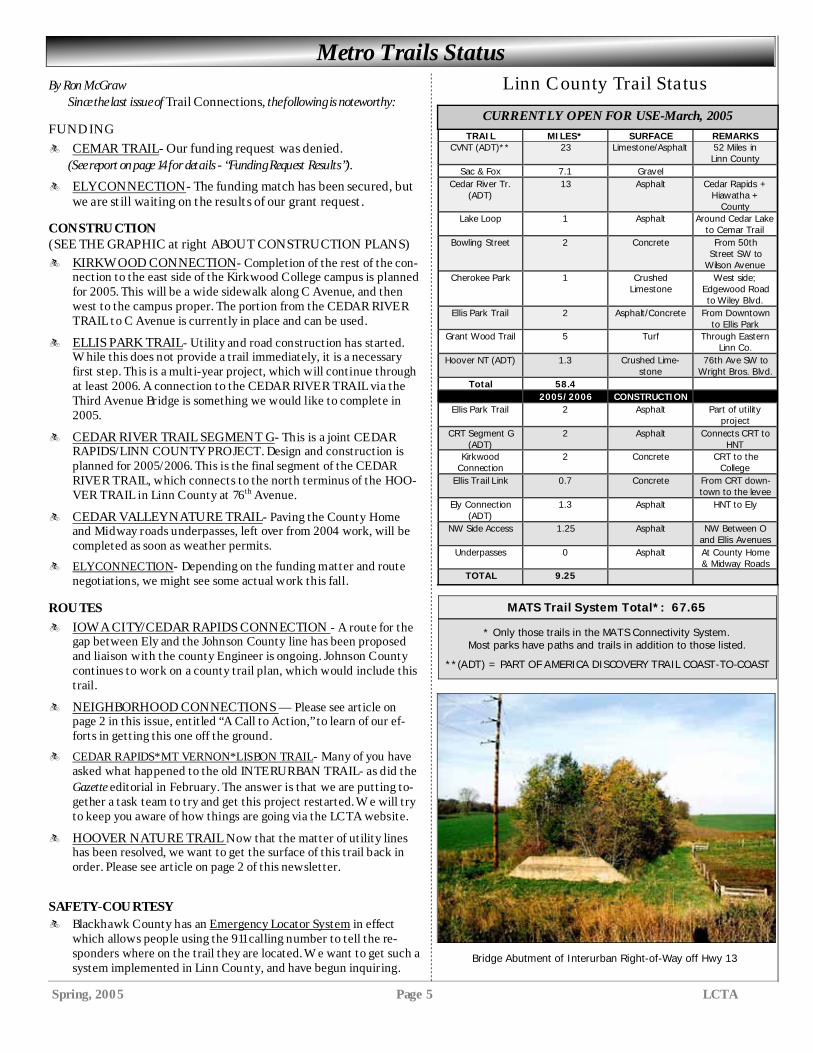
TRAIL MILES* SURFACE REMARKS CVNT (ADT)** 23 Limestone/Asphalt 52 Miles in
Linn County Sac & Fox 7.1 Gravel
Cedar River Tr. (ADT)
13 Asphalt Cedar Rapids + Hiawatha +
County Lake Loop 1 Asphalt Around Cedar Lake
to Cemar Trail Bowling Street 2 Concrete From 50th
Street SW to Wilson Avenue
Cherokee Park 1 Crushed Limestone
West side; Edgewood Road to Wiley Blvd.
Ellis Park Trail 2 Asphalt/Concrete From Downtown to Ellis Park
Grant Wood Trail 5 Turf Through Eastern Linn Co.
Hoover NT (ADT) 1.3 Crushed Lime-stone
76th Ave SW to Wright Bros. Blvd.
Total 58.4 2005/2006 CONSTRUCTION
Ellis Park Trail 2 Asphalt Part of utility project
CRT Segment G (ADT)
2 Asphalt Connects CRT to HNT
Kirkwood Connection
2 Concrete CRT to the College
Ellis Trail Link 0.7 Concrete From CRT down-town to the levee
Ely Connection (ADT)
1.3 Asphalt HNT to Ely
NW Side Access 1.25 Asphalt NW Between O and Ellis Avenues
Underpasses 0 Asphalt At County Home & Midway Roads
TOTAL 9.25
By Ron McGraw Since the last issue of Trail Connections, the following is noteworthy: FUNDING
q CEMAR TRAIL- Our funding request was denied. (See report on page 14 for details - “Funding Request Results”).
q ELY CONNECTION- The funding match has been secured, but we are still waiting on the results of our grant request.
CONSTRUCTION (SEE THE GRAPHIC at right ABOUT CONSTRUCTION PLANS)
q KIRKWOOD CONNECTION- Completion of the rest of the con-nection to the east side of the Kirkwood College campus is planned for 2005. This will be a wide sidewalk along C Avenue, and then west to the campus proper. The portion from the CEDAR RIVE R TRAIL to C Avenue is currently in place and can be used.
q ELLIS PARK TRAIL- Utility and road construction has started. While this does not provide a trail immediately, it is a necessary first step. This is a multi-year project, which will continue through at least 2006. A connection to the CEDAR RIVE R TRAIL via the Third Avenue Bridge is something we would like to complete in 2005.
q CEDAR RIVER TRAIL SEGMENT G- This is a joint CE DAR RAPIDS/LINN COUNTY PROJECT. Design and construction is planned for 2005/2006. This is the final segment of the CEDAR RIVE R TRAIL, which connects to the north terminus of the HOO-VER TRAIL in Linn County at 76th Avenue.
q CEDAR VALLEY NATURE TRAIL- Paving the County Home and Midway roads underpasses, left over from 2004 work, will be completed as soon as weather permits.
q ELY CONNECTION- Depending on the funding matter and route negotiations, we might see some actual work this fall.
ROUTES
q IOWA CITY/CEDAR RAPIDS CONNECTION - A route for the gap between Ely and the Johnson County line has been proposed and liaison with the county Engineer is ongoing. Johnson County continues to work on a county trail plan, which would include this trail.
q NEIGHBORHOOD CONNECTIONS — Please see article on page 2 in this issue, entitled “A Call to Action,” to learn of our ef-forts in getting this one off the ground.
q CEDAR RAPIDS*MT VERNON*LISBON TRAIL- Many of you have asked what happened to the old INTE RURBAN TRAIL- as did the Gazette editorial in February. The answer is that we are putting to-gether a task team to try and get this project restarted. We will try to keep you aware of how things are going via the LCTA website.
q HOOVER NATURE TRAIL Now that the matter of utility lines has been resolved, we want to get the surface of this trail back in order. Please see article on page 2 of this newsletter.
SAFETY-COURTESY
q Blackhawk County has an Emergency Locator System in effect which allows people using the 911 calling number to tell the re-sponders where on the trail they are located. We want to get such a system implemented in Linn County, and have begun inquiring.
Metro Trails Status Linn County Trail Status
CURRENTLY OPEN FOR USE-March, 2005
* Only those trails in the MATS Connectivity System. Most parks have paths and trails in addition to those listed.
**(ADT) = PART OF AMERICA DISCOVERY TRAIL COAST-TO-COAST
MATS Trail System Total*: 67.65
Bridge Abutment of Interurban Right-of-Way off Hwy 13
Linn County Trails Association page 6 www.linncountytrails.org
Send any comments and suggestions about the web page to Joe Clark, web master, at
Also, if you have an email account, and want to participate in a trails mailing list, send a
blank email to:
You will receive a welcoming message with instructions on how to use the mailing list
and how to unsubscribe.
This mailing list is intended for general discussions of trail issues, not limited to trails in Linn County.
“Cycle for the Cure”
Fun with a purpose…the MS Cycle for the Cure-Cedar Rapids is an 8-year old Father’s Day weekend tradition. Organ-ized by Cedar Valley Cycling, this event raises money for the National Multiple Sclerosis Society-Iowa Chapter. Multiple Sclerosis is a chronic, disabling disease of the cen-tral nervous system, and its cause is unknown. People living with MS depend on the National MS Society for research, ad-vocacy, support groups and information. This is made possible through fundraising events like the Cedar Rapids “Cycle for the Cure” and the other MS Bike Tour events throughout Iowa and the United States. The Cedar Rapids “Cycle for the Cure” 2005 ride is sched-uled for Saturday, June 18…rain or shine. Rides begin and end at Carlos O’Kelly’s Mexican Café on Armar Drive in Marion, Iowa. There will be rides of 100, 80, 40, 20 miles with fully sup-plied rest stops and SAG support.
In addition to these rides is the Family Fun Trail Ride on the Marion Parks Trail, which will have one rest stop and vol-unteers on the trail for rider assistance. Rides start at varying times depending upon the length of the route. After the ride, enjoy a yummy BBQ lunch, live music by Bryce Janey, face painting for the kids, post-ride massages, prizes and loads of fun for everyone. Not a bicycle rider? . . . Not a problem! Volunteers are needed to help with marking routes, assembling rider packets, working and replenishing rest stops, etc. For event information, pledge packets, registration, or to volunteer, visit the Cedar Valley Cycling website at www.cycleforthecure.org or call 319-393-8897. For more information about Multiple Sclerosis and the MS Bike Tour visit the National MS Society Iowa Chapter web-site at www.ianmss.org or call1-800-798-6677.
Check out our website: www.linncountytrails.org
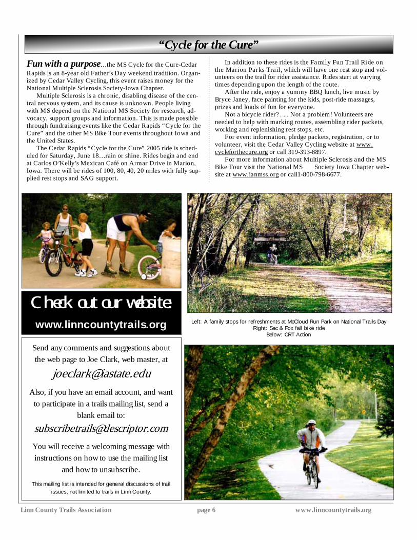
Left: A family stops for refreshments at McCloud Run Park on National Trails Day Right: Sac & Fox fall bike ride
Below: CRT Action
Spring, 2005 Page 7 LCTA
RENEWAL DATES on ADDRESS LABELS
Please check the address label on your newsletter for your renewal date.
If you renew without our sending out reminders, it saves us a lot of time and money.
So PLEASE - renew in a timely manner.
THANKS!
By Dean Barnum, Chairman, LCTA Metro Trail Map Project
Below is selected text from letters I have sent to all the cities in the area.
The Linn County Trails Association (LCTA) has printed and distributed a small trail map for a number of years. This map showed the Boyson Trail, Sac and Fox Trail, Cedar River Trail, the Grant Wood Trail, and the Cedar Valley Nature Trail. Each trail was shown separately with no rela-tionship to where they were in the Metro Area. Also, no planned trails were shown. Last year, LCTA developed and built trail boxes to place along the trails in the metro area. LCTA then kept the boxes filled with trail maps until we ran out in late fall. As a con-tinuation of this project, LCTA decided to develop a new trails map. The Metro Area has outgrown the small trail map. Now is the time to develop a new map showing all the completed and proposed trails on an all-inclusive Metro Trail Map.
LCTA has modeled this map after a similar map showing all trails in the Waterloo/Cedar Falls metro area. This trail map consists of twelve 3.75” x 8.75” panels or a total of 17.5” x 22.5” total paper size. The rear side of the map includes a table of open trails, a list of sponsors, an article about the American Discovery Trail, trail safely tips, some photos, the Cedar Valley Nature Trail map and the Grant Wood Trail map. To be able to print such a “grand” map, LCTA has found sponsors to pay for 40,000 full color maps. Distribu-tion of maps will be primarily via trail boxes along trails and to sponsors, if they desire. LCTA believes that these maps provide a service to both local trail users and tourists for the Robins/Cedar Rapids/Marion/Hiawatha/Fairfax/Ely metro area, and to Center Point, which is a prime stopping place along the Cedar Val-ley Nature Trail. The Metro Trail Map Project committee consists of Steve Nelson, Mark Trumbauer, Ron McGraw, and Dean Barnum, with assistance from Jim Healy and Mike Wilson.
New Area Trails Map Being Developed
Linn County Trails Association page 8 www.linncountytrails.org
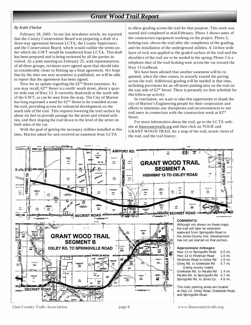
COMMENTS: Although not shown on these maps, the trail will later be extended eastward from Springville Road to the Jones County line. Development has not yet started on that portion. Approximate mileages: Hwy 13 to Springville Road 6.0 mi. Hwy 13 to Hindman Road 1.6 mi. Hindman Road to Oxley Rd 1.6 mi. Oxley Rd. to Creekside Rd 0.7 mi. (Using county roads) Creekside Rd. to Paralta Rd 1.4 mi. Paralta Rd. to Springville Rd 0.7 mi. Springville Rd. to Jones Co. 4.6 mi. The main parking areas are located at Hwy 13, Oxley Road, Creekside Road, and Springville Road.
Grant Wood Trail Report
By Keith Fletcher
February 28, 2005 - In our last newsletter article, we reported that the County Conservation Board was preparing a draft of a three-way agreement between LCTA, the County Supervisors and the Conservation Board, which would outline the terms un-der which the GWT would be transferred from LCTA. This draft has been prepared and is being reviewed by all the parties in-volved. At a joint meeting on February 25, with representatives of all three groups, revisions were agreed upon that should take us considerably closer to firming up a final agreement. We hope that by the time our next newsletter is published, we will be able to report that the agreement has been signed.
Now for an update regarding the 62nd Street extension. As you may recall, 62nd Street is a north/south street, about a quar-ter mile east of Hwy 13. It currently dead-ends at the north side of the GWT, as can be seen from the map. The City of Marion has long expressed a need for 62nd Street to be extended across the trail, providing access for industrial development on the south side of the trail. This requires lowering the trail surface by about six feet to provide passage for the street and related utili-ties, and then sloping the trail down to the level of the street on both sides of the cut.
With the goal of getting the necessary utilities installed at this time, Marion asked for and received an easement from LCTA
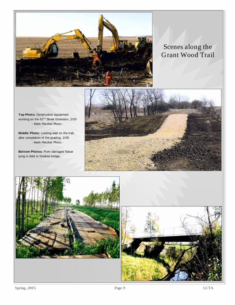
to allow grading across the trail for that purpose. This work was started and completed in mid-February. Photo 1 shows some of the construction equipment working on the project. Photo 2, looking east, shows the trail after the completion of the grading, and the installation of the underground utilities. A 14-foot wide layer of rock was applied to the graded surface of the trail and the shoulders of the trail are to be seeded in the spring. Photo 3 is a telephoto shot of the trail looking west across the cut toward the Hwy 13 trailhead. We have been advised that another easement will be re-quested, when the time comes, to actually extend the paving across the trail. Additional grading will be needed at that time, including provisions for an off-street parking area on the trail on the east side of 62nd Street. There is presently no firm schedule for this follow-up activity. In conclusion, we want to take this opportunity to thank the city of Marion’s Engineering people for their cooperation and efforts to minimize any disruptions and inconveniences to our trail users in connection with the construction work at 62nd Street.
For more information about the trail, go to the LCTA web-site at linncountytrails.org and then click on TOUR and GRANT WOOD TRAIL for a map of the trail, scenic views of the trail, and the trail history.
Spring, 2005 Page 9 LCTA
Scenes along the Grant Wood Trail
Top Photo: Construction equipment working on the 62nd Street Extension, 2/05
- Keith Fletcher Photo - Middle Photo: Looking east on the trail, after completion of the grading, 2/05
- Keith Fletcher Photo - Bottom Photos: From damaged flatcar lying in field to finished bridge.
Linn County Trails Association page 10 www.linncountytrails.org
On the Road Again
A Solo Adventure from Muscatine, Iowa, to Bar Harbor, Main
By Ed Hayek
Last May, former board member Ed Hayek made a solo bike trip to Maine, utilizing several trails. The following is the first in a series of two reports.
I found myself standing alone, looking at the bridge that crosses the Mississippi River into Illinois, at Muscatine, Iowa. My son had given me a ride to Muscatine that morn-ing, to help make up for the two extra days’ time I had spent preparing for this adven-ture. We had unloaded my bike and gear and he was gone. This was it; I was alone. Suddenly, Bar Harbor, Maine (my ultimate destination) felt a long distance away.
As I started over the bridge, many thoughts raced through my mind. Fore-most were the grand thoughts of adven-ture and freedom. What would I find out about myself, the country, and inhabi-tants of the various states I would pass through? Also present were the darker thoughts. What if I couldn’t do this? Had I done enough preparation? It was even pos-sible, through some unlikely misfortune, that I would never see home again. It was with very mixed emotions that I crossed that bridge. Soon I saw a sign, “Welcome to Illinois,” and all seemed rosy again.
Although the majority of the Adven-ture Cycling Northern Tier Bicycle Route is on paved roads, the route also makes use of several trails and bikeways. These trails provide welcome breaks from the constant vigilance needed when riding on the road. They also provide their own hazards, as the reader will learn. This article is intended to highlight the use of trail portions during my adven-ture.
The first four days were spent traveling through almost flat Illi-nois. The route followed lightly-traveled back
roads, and although the weather wasn’t perfect, the constant waves from friendly farmers made for a pleasant experience. Overnight camping was in the communi-ties of Cambridge, Henry, Odell, and Iro-quois. The weather was cold and wet but luckily I was able to sleep under a shelter and avoided putting up a tent all but one night. In Iroquois I was put up in the city hall, complete with a shower. The cycling maps carry instructions such as “see the po-lice” or “ask the mayor” [about lodging]. In Illinois, my average total travel cost per day, including camping, was $17.00.
The next three days I traveled across the state of Indiana and experienced the same courtesy and friendliness as I had in Illinois. The population was a little sparse at times and at one point the towns were 40 miles apart. One of my campsites in an Indiana State Park cost $20.00, but I thought this beautiful spot was a well worth it after an 82-mile day. As I watched the sunset overlooking Salamo-nie Lake, I was sure of it.
My last night in Indiana was at Mon-roeville, indoors in the community center, complete with shower, washer/dryer and complete kitchen. Nirvana! This was es-pecially appreciated as I arrived thor-oughly soaked and chilled to the bone. In case it hasn’t yet been made clear, the first part of this adventure was cold and wet!
On the eighth day I crossed into Ohio. It was a beautiful ride, slightly more roll-ing, with more wildflowers, and following the Auglaize and Maumee rivers. The
Maumee had locks from the original Erie/Ohio Canal.
My route passed the birthplace of Chief Pontiac, prominent in the British American war. I visited the Rutherford Hayes Presidential Center (19th presi-dent) in Freemont. Not a great museum, but the friendly folks secured my bike in a maintenance shed while I toured. After the museum, I welcomed my first oppor-tunity to use a bicycle trail, a seven-mile section of the North Inlet bike trail be-tween Freemont and Clyde, Ohio. There was nothing overly memorable about the trail, but it was in great condition, and provided a wonderful break from traffic.
Day Ten put me on Lake Erie—another milestone. I elected to take the afternoon off, set up camp, and read a book in the sun. Yeah right!
Shortly after I set up camp it got very cloudy, so I returned to my campsite. The owner ran out and informed me that 95-MPH winds were headed across the lake and I should put my gear in a cabin they were renovating. As a storm raged outside, I found myself resting on a plush mattress.
After a few miles on a busy road west of Cleveland, I soon found myself on a welcome bike route, traversing nice neighborhoods and paths along the lake, and bringing me to the center of the city. A quick trip over the Detroit Superior Bridge and I was directly downtown, rid-ing by the Cleveland Browns’ stadium, as well as cultural areas. Trails along the lake, through various suburban parks,
made the exit out of the east side of Cleveland easy all the way to Euclid, but then the heavy traffic resumed. Much of the following day the route paralleled the lakeshore, making for very nice scenery. The town of Geneva on the Lake reminded me a lot of the Wisconsin Dells—pretty but somewhat tacky. I passed through Ashtabula, the city after which the one-piece bicy-cle crank is named (as it was manufactured there, and used in older Schwinns and other
(Continued on page 11)
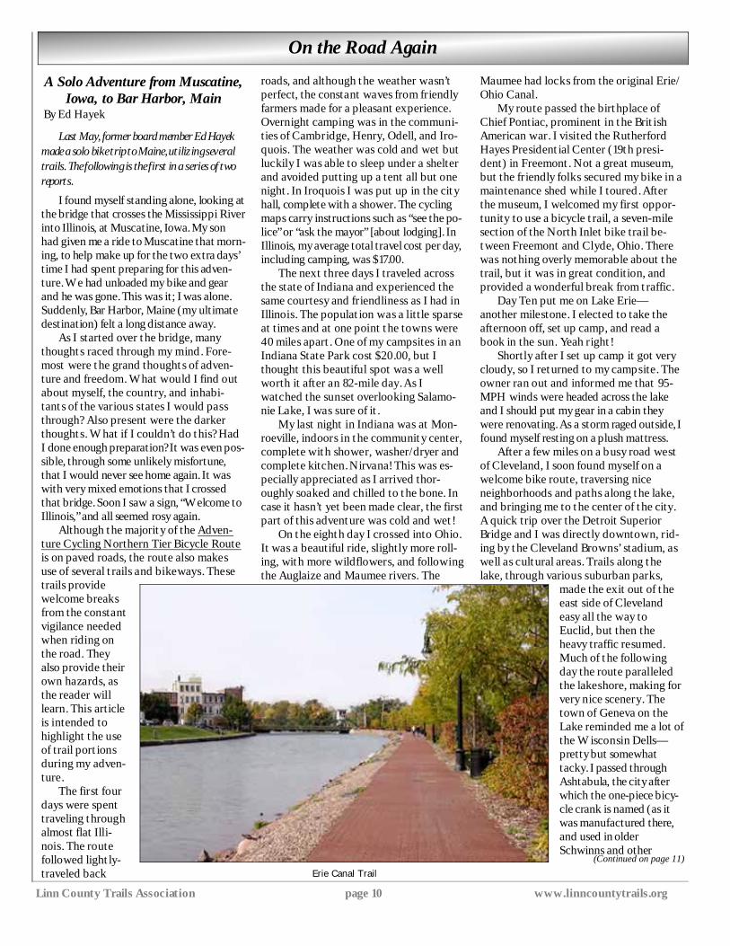
Erie Canal Trail
Spring, 2005 Page 11 LCTA
“Hayek;” (Continued from page 10) brands). Ashtabula was also the northern terminus of the Slave Underground Rail-road.
It was near Ashtabula that I finally met my first long distance cyclist. Jessica, from Boston, was traveling solo to Door County, Wisconsin to attend a family re-union in June, visiting friends along the way. It was really great to compare notes with someone having similar experiences. At that point we had each traveled about 750 miles in opposite directions. But alas—after dark even mosquito coils could not keep the little buggers at bay, and we were forced to cut the conversa-tion short and retreat to our tents.
On Day 13, I cycled through three states! I completed the Ohio portion, cov-ered 46 miles of Pennsylvania, still in view of the lake, and 11 miles of New York. There were some pretty views overlook-ing vineyards along the lake.
One of the fun parts of a trip like this is talking to and getting advice from locals. I stopped at Conneaut, Ohio for breakfast and got into a conversation with four older gentlemen. They told me of the demolition of an old bridge on my route, forcing an alternate route. Those four gentlemen gave me four different sets of detailed direc-tions, regarding a detour!
Once you are this far east there are historical markers all over the place, but as Jessica had said the day before, you don’t know which ones are worth stop-ping for, and you can’t stop at all of them.
By evening I was within 80 miles of Niagara Falls by car, although my route was longer. After a stay at KOA, I had a hungry morning ride searching for “Aunt Millies” of breakfast fame. When I asked for directions from a motorist, I was told it was “just down the road,” which turned out to be “just” 35 miles away!
The high point of this day was a visit to the Bicycle Pedaling History Museum at Orchard Park, New York. Here, a tre-mendous collection of bicycles can be found. I have never seen such a complete collection spanning all eras from the 1800’s through the seventies. If you are ever in the Buffalo, New York area, it is a must-see.
The sky was overcast and it started to rain when I left the museum. The next 10 miles of cycling was quite frightening, as I mixed with trucks and other rush hour traffic in limited visibility on a four lane road with curbs eliminating the possibil-ity of jumping off if things got dicey. Eventually, the route moved through dying or abandoned manufacturing areas, then along lakeside parks. Before I knew it, I was at the Peace Bridge, crossing into Canada. By the time I exited Customs, it was really pouring and almost dark. I found a campground and stood in pouring rain, negotiating with the owner shouting
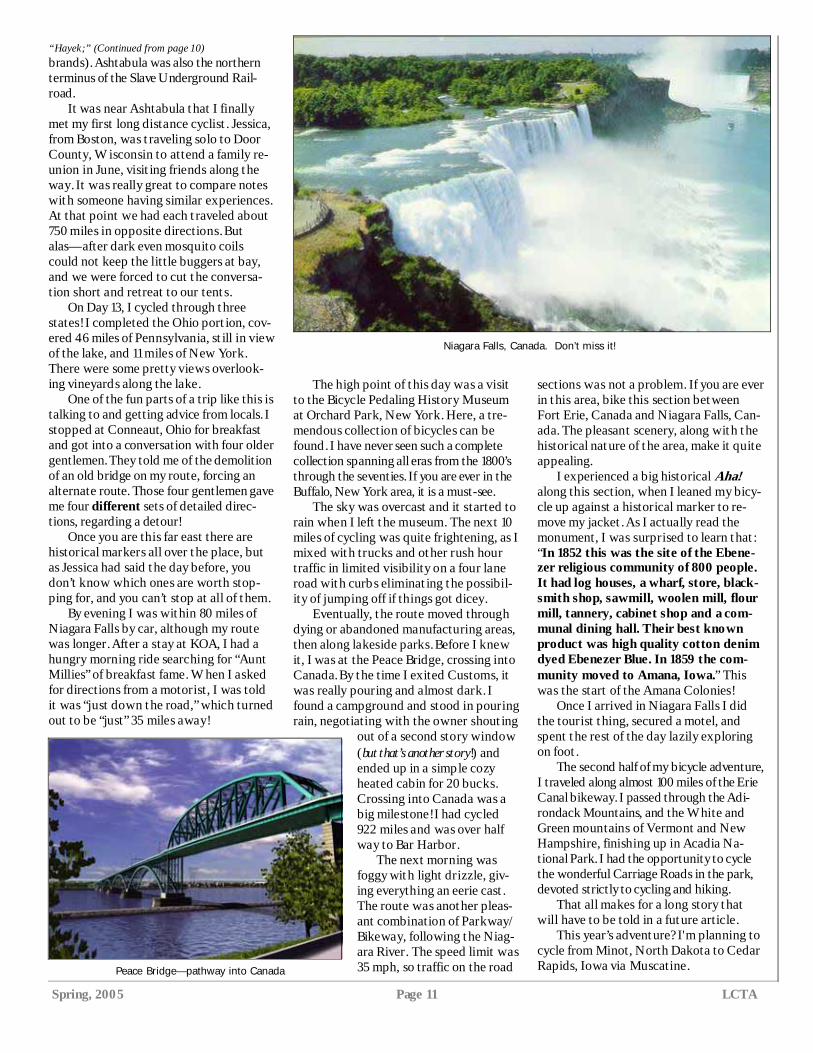
out of a second story window (but that’s another story!) and ended up in a simple cozy heated cabin for 20 bucks. Crossing into Canada was a big milestone! I had cycled 922 miles and was over half way to Bar Harbor. The next morning was foggy with light drizzle, giv-ing everything an eerie cast. The route was another pleas-ant combination of Parkway/Bikeway, following the Niag-ara River. The speed limit was 35 mph, so traffic on the road
sections was not a problem. If you are ever in this area, bike this section between Fort Erie, Canada and Niagara Falls, Can-ada. The pleasant scenery, along with the historical nature of the area, make it quite appealing.
I experienced a big historical Aha! along this section, when I leaned my bicy-cle up against a historical marker to re-move my jacket. As I actually read the monument, I was surprised to learn that: “In 1852 this was the site of the Ebene-zer religious community of 800 people. It had log houses, a wharf, store, black-smith shop, sawmill, woolen mill, flour mill, tannery, cabinet shop and a com-munal dining hall. Their best known product was high quality cotton denim dyed Ebenezer Blue. In 1859 the com-munity moved to Amana, Iowa.” This was the start of the Amana Colonies!
Once I arrived in Niagara Falls I did the tourist thing, secured a motel, and spent the rest of the day lazily exploring on foot.
The second half of my bicycle adventure, I traveled along almost 100 miles of the Erie Canal bikeway. I passed through the Adi-rondack Mountains, and the White and Green mountains of Vermont and New Hampshire, finishing up in Acadia Na-tional Park. I had the opportunity to cycle the wonderful Carriage Roads in the park, devoted strictly to cycling and hiking.
That all makes for a long story that will have to be told in a future article.
This year’s adventure? I'm planning to cycle from Minot, North Dakota to Cedar Rapids, Iowa via Muscatine. Peace Bridge—pathway into Canada
Niagara Falls, Canada. Don’t miss it!

Linn County Trails Association page 12 www.linncountytrails.org
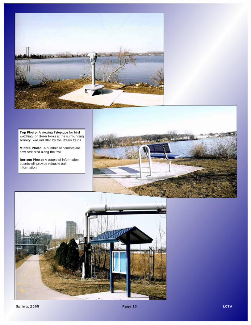
The trail that circles Cedar Lake got some serious upgrades, thanks to seven local Rotary Clubs. The clubs financed and provided labor to install a number of amenities to the trail, including shelters, benches, information
boards, and a viewing telescope. This civic-minded organization settled on the trail project after examining a number of ideas, and the trail community should
be very grateful for these wonderful improvements. The trail loop around Cedar Lake comes off of the Cedar River Trail and is almost a mile and a half long. If you are looking for a
good hike or bike ride, check out the improvements. Thanks, Rotarians!
Rotary Clubs Provide Improvements to Cedar Lake Trail
Three shelters like this one are located on the Lake Loop
Trail.
A Project Board describes the
project. At left in this
photo, is a rotary gear wheel design made of pavers.
Spring, 2005 Page 13 LCTA
Top Photo: A viewing Telescope for bird watching, or closer looks at the surrounding scenery, was installed by the Rotary Clubs. Middle Photo: A number of benches are now scattered along the trail Bottom Photo: A couple of information boards will provide valuable trail information.
Spring, 2005 Page 13 LCTA
Linn County Trails Association page 14 www.linncountytrails.org
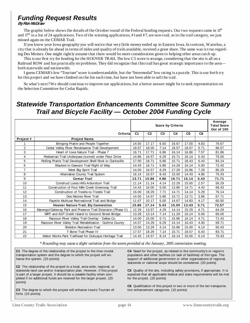
Funding Request Results By Ron McGraw
The graphic below shows the details of the October round of the Federal funding requests. Our two requests came in 11th and 17th in a list of 24 applications. Two of the winning applications, #1 and #7, are non-trail, so in the trail category, we just missed again on the CEMAR Trail.
If you know your Iowa geography you will notice that very little money ended up in Eastern Iowa. In contrast, Waterloo, a city that is already far ahead in terms of miles and quality of trails available, received a great share. The same was is true regard-ing Des Moines. One might rightly assume that there would be more consideration given to helping other areas catch up.
This is our first try for funding for the HOOVER TRAIL The low C5 score is strange, considering that the site is all on a Railroad ROW and has practically no problems. They did recognize that this trail has great strategic importance to the area—both statewide and nationwide.
I guess CEMAR’s low “Tourism” score is understandable, but the “Intermodal” low rating is a puzzle. This is our forth try for this project and we have climbed on the list each time, but have not been able to sell the trail.
So what’s next? We should continue to improve our applications, but a better answer might be to seek representation on the Selection Committee for Cedar Rapids.
Score By Criteria Average Total Score Out of 100
Criteria C1 C2 C3 C4 C5 C6
Project # Project Name 1 Bringing Prairie and People Together 14.50 17.17 6.50 16.67 17.00 4.83 76.67 2 Cedar Valley River Renaissance Trail Development 18.57 18.00 7.14 18.57 18.57 5.71 86.57 3 Heart of Iowa Nature Trail - Phase 7 16.71 17.71 6.86 16.14 16.86 7.57 81.86 4 Pedestrian Trail Underpass (tunnel) under Fleur Drive 14.86 16.57 6.29 15.71 16.14 5.43 75.00 5 Rolling Prairie Trail Development Shell Rock to Clarksville 17.00 18.71 6.86 15.71 18.43 6.43 83.14 6 Waukee to Dawson Trail Right of Way 14.43 16.71 5.86 14.29 16.14 5.00 72.43 7 West Big Spirit Trail 14.00 16.57 8.29 17.29 16.86 7.29 80.29 8 Allamakee County Trail System 16.14 16.57 8.43 15.00 14.43 4.86 75.43 9 Cemar Trail 13.71 15.86 4.86 16.71 15.14 5.43 71.71 10 Construct Loess Hills Arboretum Trail 11.14 11.14 4.14 12.29 15.00 2.57 56.29 11 Construction of Four-Mile Creek Greenway Trail 14.43 16.00 5.00 13.86 14.71 4.43 68.43 12 Construction of Trestle-to-Trestle Trail 16.00 18.29 7.71 14.71 14.14 5.29 76.14 13 Des Moines River Trail 14.00 14.57 5.86 15.71 13.71 3.86 67.71 14 Fayette Multiuse Recreational Trail and Bridge 11.67 10.17 5.00 14.67 14.83 4.17 60.50 15 Hoover Nature Trail, Ely Connection 15.86 17.14 5.43 15.00 13.43 5.71 72.57 16 Marengo/Gateway Park and Preserve Trail Extension (Phase II) 12.29 13.57 4.29 14.14 15.29 4.71 64.29 17 MRT and ADT Credit Island to Concord Street Bridge 13.29 13.14 7.14 11.29 15.14 5.00 65.00 18 Raccoon River Valley Trail Overlay - Dallas Co. 14.00 15.00 5.71 15.86 16.14 4.71 71.43 19 Raccoon River Valley Trail Rehabilitation - Guthrie County 14.57 14.29 6.29 14.14 16.43 4.00 69.71 20 Sheldon Recreation Trail 13.00 13.29 4.14 15.86 15.00 4.14 65.43 21 T-Bone Trail Phase IV 17.57 18.29 7.14 15.71 18.57 6.43 83.71 22 Water Works Park Trailhead for Dubuque Heritage Trail 14.43 14.57 8.14 16.14 16.00 6.14 75.43
Statewide Transportation Enhancements Committee Score Summary Trail and Bicycle Facility — October 2004 Funding Cycle
C1 The degree of the relationship of the project to the inter-modal transportation system and the degree to which the project will en-hance the system. (20 points) C2 The relationship of the project to a local, area wide, regional, or statewide land use and/or transportation plan. However, if this project is part of a larger project, it should be a useable facility when com-pleted if no additional funds are received for the larger project. (20 points) C3 The degree to which the project will enhance Iowa's Tourism ef-forts. (10 points)
C4 Need for the project, as related to the community’s or region’s population and other facilities (or lack of facilities) of this type. The support of additional government or other organizations of regional, statewide or national scope should be considered. (20 points) C5 Quality of the site, including safety provisions, if appropriate. It is expected that all applicable federal and state requirements will be met for the project. (20 points) C6 Qualification of this project in two or more of the ten transporta-tion enhancement categories. (10 points)
* Rounding may cause a slight variation from the scores provided at the January, 2005 commission meeting.
Score by Criteria
Spring, 2005 Page 15 LCTA
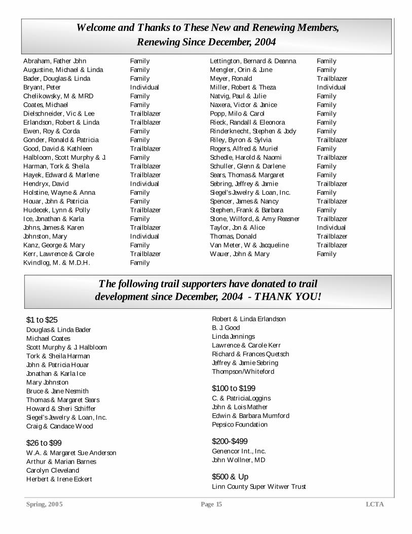
Welcome and Thanks to These New and Renewing Members, Renewing Since December, 2004
Abraham, Father John Family Augustine, Michael & Linda Family Bader, Douglas & Linda Family Bryant, Peter Individual Chelikowsky, M & MRD Family Coates, Michael Family Dielschneider, Vic & Lee Trailblazer Erlandson, Robert & Linda Trailblazer Ewen, Roy & Corda Family Gonder, Ronald & Patricia Family Good, David & Kathleen Trailblazer Halbloom, Scott Murphy & J. Family Harman, Tork & Sheila Trailblazer Hayek, Edward & Marlene Trailblazer Hendryx, David Individual Holstine, Wayne & Anna Family Houar, John & Patricia Family Hudecek, Lynn & Polly Trailblazer Ice, Jonathan & Karla Family Johns, James & Karen Trailblazer Johnston, Mary Individual Kanz, George & Mary Family Kerr, Lawrence & Carole Trailblazer Kvindlog, M. & M.D.H. Family
Lettington, Bernard & Deanna Family Mengler, Orin & June Family Meyer, Ronald Trailblazer Miller, Robert & Theza Individual Natvig, Paul & Julie Family Naxera, Victor & Janice Family Popp, Milo & Carol Family Rieck, Randall & Eleonora Family Rinderknecht, Stephen & Jody Family Riley, Byron & Sylvia Trailblazer Rogers, Alfred & Muriel Family Schedle, Harold & Naomi Trailblazer Schuller, Glenn & Darlene Family Sears, Thomas & Margaret Family Sebring, Jeffrey & Jamie Trailblazer Siegel’s Jewelry & Loan, Inc. Family Spencer, James & Nancy Trailblazer Stephen, Frank & Barbara Family Stone, Wilford, & Amy Reasner Trailblazer Taylor, Jon & Alice Individual Thomas, Donald Trailblazer Van Meter, W & Jacqueline Trailblazer Wauer, John & Mary Family
$1 to $25 Douglas & Linda Bader Michael Coates Scott Murphy & J. Halbloom Tork & Sheila Harman John & Patricia Houar Jonathan & Karla Ice Mary Johnston Bruce & Jane Nesmith Thomas & Margaret Sears Howard & Sheri Schiffer Siegel’s Jewelry & Loan, Inc. Craig & Candace Wood
$26 to $99 W.A. & Margaret Sue Anderson Arthur & Marian Barnes Carolyn Cleveland Herbert & Irene Eckert
Robert & Linda Erlandson B. J. Good Linda Jennings Lawrence & Carole Kerr Richard & Frances Quetsch Jeffrey & Jamie Sebring Thompson/Whiteford
$100 to $199 C. & PatriciaLoggins John & Lois Mather Edwin & Barbara Mumford Pepsico Foundation
$200-$499 Genencor Int., Inc. John Wollner, MD
$500 & Up Linn County Super Witwer Trust
The following trail supporters have donated to trail development since December, 2004 - THANK YOU!
Linn County Trails Association page 16 www.linncountytrails.org
Mail donations and membership to: Linn County Trails Association
PO Box 2681 Cedar Rapids, Iowa 52406
Linn County Trails Association (LCTA) Membership Application
NON-PROFIT ORG. U.S. POSTAGE PAID
Center Point, IA 52213-0131
Permit No. 7
Iowa Trails Council PO Box 131 Center Point, IA 52213-0131 ADDRESS SERVICE REQUESTED
Information required to join the LCTA:
Name(s):
Address:
City/State/Zip: E-Mail: Please print the information CLEARLY
Membership in the LCTA is Tax Deductible
TRAIL BLAZER $100* TRAIL PARTNERS (Family) $ 35* TRAIL SCOUT $ 20
* At the Trail Partner level or higher, members also receive the “Advocate”, the newsletter of the Iowa Trails Council.
Please consider an additional donation for NEW TRAIL DEVELOPMENT $______
I would like to help with an LCTA committee: (Optional—mark one or more): Grant Wood Trail / Publicity and Events / Fund Raising / None at this time
Inside this Issue
President’s Message/Board Members/Officers
1
Call to Action 2
Linda Langston 3
A Trail of Their Own (Dog Park) 4
Metro Trails Status 5
“ Cycle for the Cure” 6
New Area Trails Map Development 8
Grant Wood Trail Report 8-9
On the Road Again 10-11
Rotary Project on Cedar Lake Trail 12-13
Funding Request Results 14
New & Renewing Members 15
Donations 15
Membership Information 16
Why would I want to join the LCTA? 1. Your membership will count you among the hundreds of enthusiastic trail advocates who make up the Linn County Trails Association. 2. By becoming a member you will have already begun to play an important role in building a network of connected trails in Linn County and the
surrounding area. 3. 95% of all money raised through memberships, donations, and grants goes directly to build more trails or to improve existing trails. LCTA has
been able to multiply the financial support of its members by providing matching funds to secure significant grants. 4. As a member you will receive our quarterly newsletter. Here you can read about trail vacations, upcoming trail events, opportunities to volun-
teer, and issues that are important to trail development. Each issue features a detailed matrix, which explains the current status of trails in the planning or construction stages.
5. Members are not expected to attend meetings and no one will call you. Of course, if you want to get involved, we will welcome your help.
Learn more about LCTA by visiting our website at www.linncountytrails.org


![Research Article Design of a Minimized Complementary ... › journals › ijap › 2015 › 932495.pdfopment of interesting devices including superscatterer [ ], concentrators [ ],](https://img.pdfslide.us/doc/110x75/60b74cfba553ab2dab62d754/research-article-design-of-a-minimized-complementary-a-journals-a-ijap-a.jpg)