Embed Size (px)
Citation preview

ArcGIS10
Luana ValentiniInternetGIS course - 2011
ArcScene - ArcGlobe
3D analysis

3D in ArcGIS10
● ArcScene ● ArcGlobe

3D AnalystExtension of ArcGIS that provides tools to:
- Interactive visualization of 3D spatial data;
- 3D Geoprocessing tool;
- Publish globe services (with ArcGIS Server) and globe documents (Publisher toolbar).
Data:
- Vector data (points, lines, polygons, etc.)
- Data for surface creation:
- TINs - Rasters- Terrain datasets

● Volumetric Shadows
● Maximum Height Based on Visibility
● Skyline Analysis
● Space Management
3D Analysis
● Interior Visibility
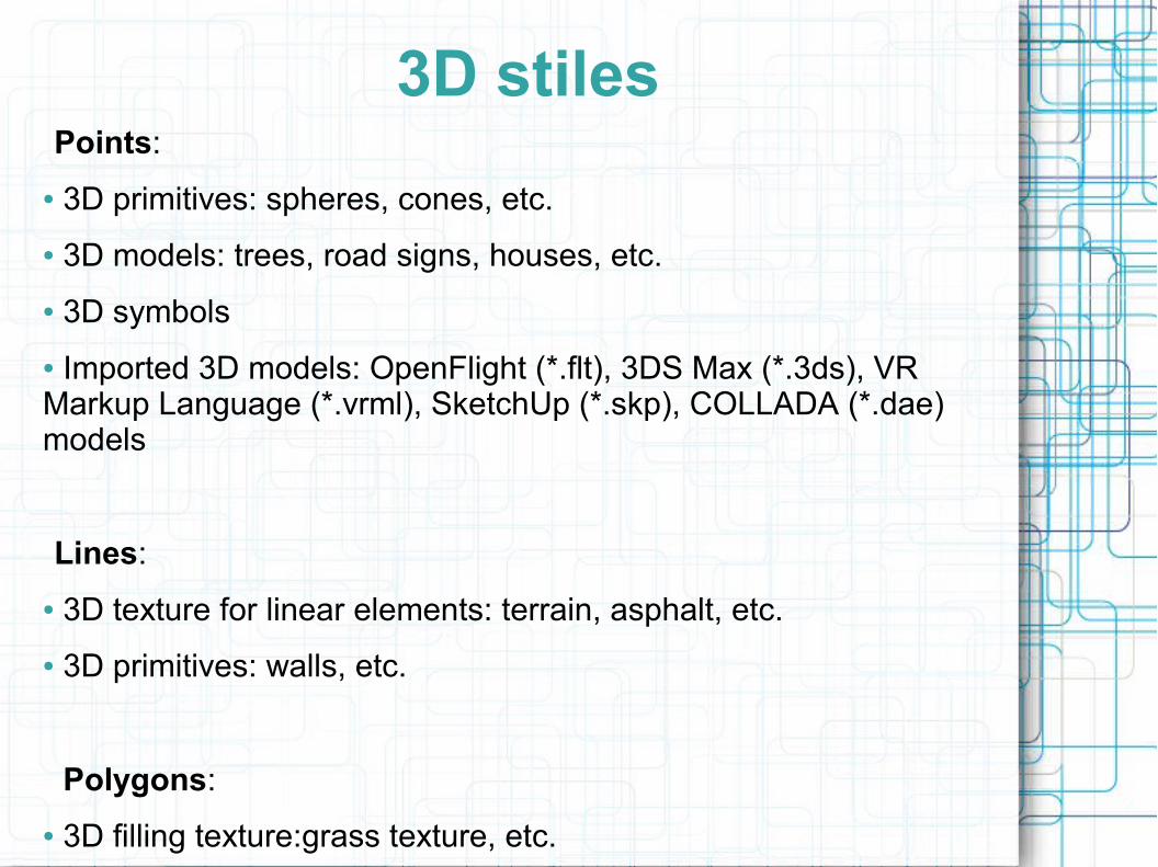
Points:● 3D primitives: spheres, cones, etc.● 3D models: trees, road signs, houses, etc.● 3D symbols● Imported 3D models: OpenFlight (*.flt), 3DS Max (*.3ds), VR Markup Language (*.vrml), SketchUp (*.skp), COLLADA (*.dae) models
Lines: ● 3D texture for linear elements: terrain, asphalt, etc.● 3D primitives: walls, etc.
Polygons:● 3D filling texture:grass texture, etc.
3D stiles

3D Graphics toolbar:● Points, lines, polygons digitization● Apply 3D symbology to the graphical elements.
KML (ArcGlobe):● Import KML data, with the proper toolbar● Support KML 2.2
Animation toolbar
3D graphic and KML support

Supported programming languages:● VB, .NET, Java, C++, etc.● Visual Basic for Applications (VBA)
Globe control and Scene control:● Integrable in custom applications;● Can read documents created with the standard verision
Customization

● Application for 3D visualization
● Suitable for study areas of limited extension
● Supports stereoscopic vision
ArcScene

Real time managing of:● Transparency● Front/backface culling● Light● Depth priority (ArScene only)● Brightness and contrast (ArcGlobe only)● Swipe tool (ArcGlobe only)● Flicker tool (ArcGlobe only)
Layer transparency
Layer face culling
Layer lighting
Shading modeChange depth priority
3D effects toolbar

● Animation: you can create an exportable video
● Base heights:
ArcScene

ArcGlobeApplication for 3D visualization:
- data positioning on a virtual globe
- oblique view of the map
Caching:
- disk cache and memory cache
- different levels of detail (raster data)

● ArcGlobe layers:
– Elevation layers: define the surface
– Draped layers: lean on the surface
– Floating layers:● Floating without a surface
● Floating on a custom surface
ArcGlobe

Extrusion● It is possible to extrude features in a layer:

Extrusion● It is possible to extrude features in a layer:
– building heights

● It is possible to create a new 3D object and edit it:
● http://www.esri.com/software/arcgis/extensions/3danalyst/demos.html
3D Editing

● Data models
● Documentation
● Focused Tools
Virtual City Templates

Virtual Philadelphia example

What is the recommended workflow between SketchUp
and ArcGIS?● The ArcGIS SketchUp plug-in is no longer supported at
ArcGIS 10. The recommended workflow is now as follows:
* Digitize in your polygon.
* Extrude it by an attribute in 3D.
* Convert it to a multipatch using Layer 3D to Feature Class.
* Export it to COLLADA using MPatch to COLLADA.
* Import/Edit in SketchUp (e.g., textures, pitched roof, etc.).
* Then use the edit environment to replace the MPatch feature with the new SKP model.