Embed Size (px)
Citation preview

ArcGIS Solutions for Water Utilities:
An OverviewJoel Smith
Gelisa Slyer

Agenda
• ArcGIS Solutions
• Solutions Site
• Deployment Options
• Water Solutions
- Foundations
- Water Outage

ArcGIS Solutions – A Collection of Industry Specific Templates and Tools
Free and Fully Supported
Available at solutions.arcgis.com
ArcGIS Solutions for
Local Government
ArcGIS Solutions for
State Government
ArcGIS Solutions for
Water Utilities
ArcGIS Solutions for
Gas Utilities
ArcGIS Solutions for
Telecommunications
ArcGIS Solutions for
Electric
ArcGIS Solutions for
Defense
ArcGIS Solutions for
Business
ArcGIS Solutions for
Emergency Management
ArcGIS Solutions for
Intelligence
ArcGIS Solutions
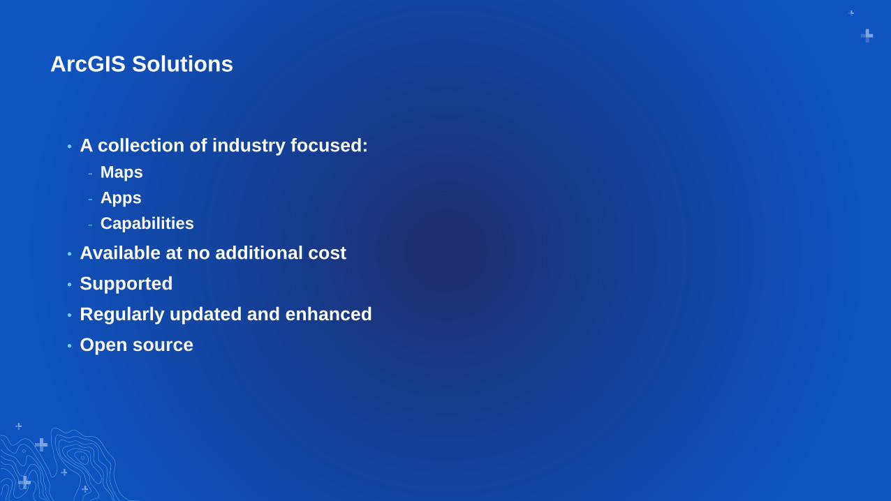
• A collection of industry focused:
- Maps
- Apps
- Capabilities
• Available at no additional cost
• Supported
• Regularly updated and enhanced
• Open source

Solutions Sitehttps://solutions.arcgis.com/water/water-delivery/

Deployment Options

Manual Deployment
• Available on Solutions site
• Download from an ArcGIS
Solutions page
• Follow documentation to
deploy

Automated Deployment
• Solution Deployment Tool
- ArcGIS Pro Add-in
- http://solutions.arcgis.com/shared/help/
deployment-tool
• Catalog of ArcGIS Solutions
• Deploy Solutions to ArcGIS Online or
Portal for ArcGIS
- Based on solution requirements

Foundations

Water Geometric Network Editing and Analysis
• Based on the Geometric Network
• 10+ years of development
• All future development will be focused on bug fixes

Water Distribution Foundations
…organizations can move from Hosted to Utility Network to gain more robust capabilities
Water Distribution Utility Network
Foundation
(Enterprise Geodatabase)
Utility Network
Management
ArcGIS
Enterprise+
• Fast start for small organizations
• Minutes to deploy
• Deployed in ArcGIS Online
• Simple features only
• No network capabilities
• No versioning
• Use ArcGIS Pro for precision edits and
topology
• Deployed in a PaaS Environment (ArcGIS Enterprise)
• You must provide and mange the computing infrastructure
• Leverage the Utility Network
• Takes Longer to Deploy
• Highly customizable
• Versioning
• Easier to localize schema
• Generally more appropriate for a mid to large size utility
Water Distribution System
Foundation
(Simple Hosted Services)
ArcGIS
Online

Information Model
• Foundation for workflows and comprehensive solutions
• Starting place for an implementation
• Components
- Schema to represent a utility system
- Pre-configured maps
- Sample data
- Deployment instructions
- Data dictionaries
- Guides for representing assets (in development)

Water Distribution Utility Network Foundation EGDB Information Model
Utility Network/Feature Service Publishing Map Map Service Publishing MapSchema
Utility Network
Management
ArcGIS
Enterprise+
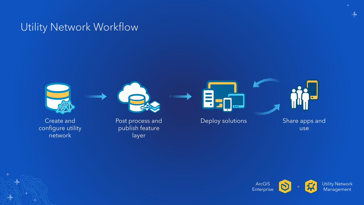
Utility Network Workflow
Create and configure utility
network
Post process and publish feature
layer
Deploy solutions Share apps and use
Utility Network Management
ArcGISEnterprise
+
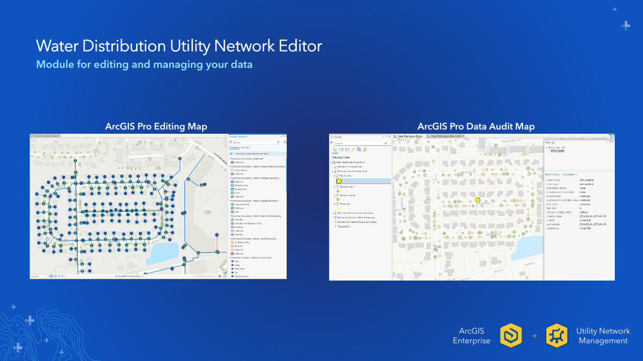
Water Distribution Utility Network EditorModule for editing and managing your data
ArcGIS Pro Editing Map ArcGIS Pro Data Audit Map
Utility Network Management
ArcGISEnterprise
+

Water Distribution System FoundationSimple Hosted Service
Viewer Web MapServices and Views Layers in a Service
ArcGISOnline

Water Outage
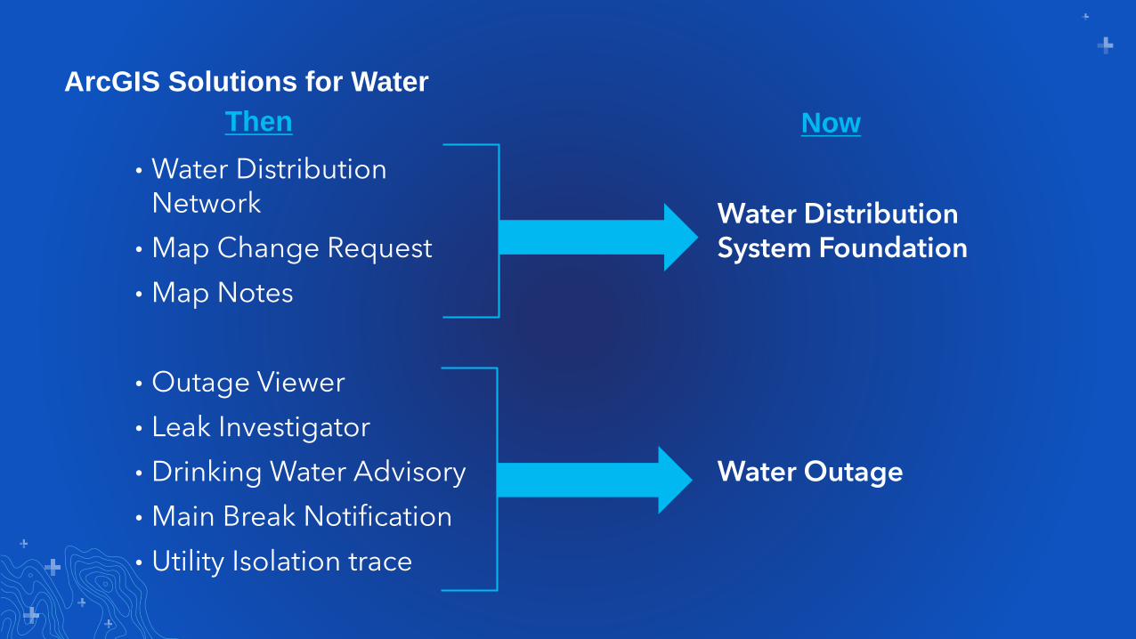
• Water Distribution Network
• Map Change Request
• Map Notes
• Outage Viewer
• Leak Investigator
• Drinking Water Advisory
• Main Break Notification
• Utility Isolation trace
Water Distribution System Foundation
Water Outage
ArcGIS Solutions for Water
Then Now

Water Outage
• Builds upon the Water Distribution System Foundation template
• Maps and apps that can be used to
- Quickly identify the extent of a main break
- Notify appropriate staff
- Inform the public
- Monitor response activities
• Use ArcGIS Online and ArcGIS Enterprise

Water Outage TemplateStoryMap guides that detail the workflow

Leak Investigator Start a Leak Assignment in the field

Leak Investigator Open Collector using the app link

Leak Investigator Locate the leak
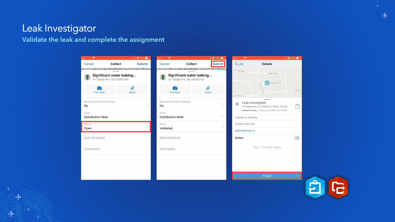
Leak Investigator Validate the leak and complete the assignment

Summary
• Introduction to ArcGIS Solutions
• Learned about the Solutions site
• Deployment Options
• Overview of popular solutions for Water

Next Steps
• If you need help implementing a solution contact Esri
• Explore the available Water solution on the Solutions site
• Let us know your feedback and suggestions on GeoNet
• Visit us at the Solution for ArcGIS Utilities Solutions area

Please Share Your Feedback in the App
Download the Esri
Events app and find
your event
Select the session
you attended
Scroll down to
“Survey”
Log in to access the
survey
Complete the survey
and select “Submit”

Questions?


![SGX-SSD: A Policy-based Versioning SSD with Intel SGX · Existing Solution: Versioning SSD[BVSSD, Systor12], [Project Almanac, Eurosys19] §Versioning SSD implements versioning system](https://img.pdfslide.us/doc/110x75/60ae19522c0a8f54c27ad581/sgx-ssd-a-policy-based-versioning-ssd-with-intel-sgx-existing-solution-versioning.jpg)