Embed Size (px)
Citation preview
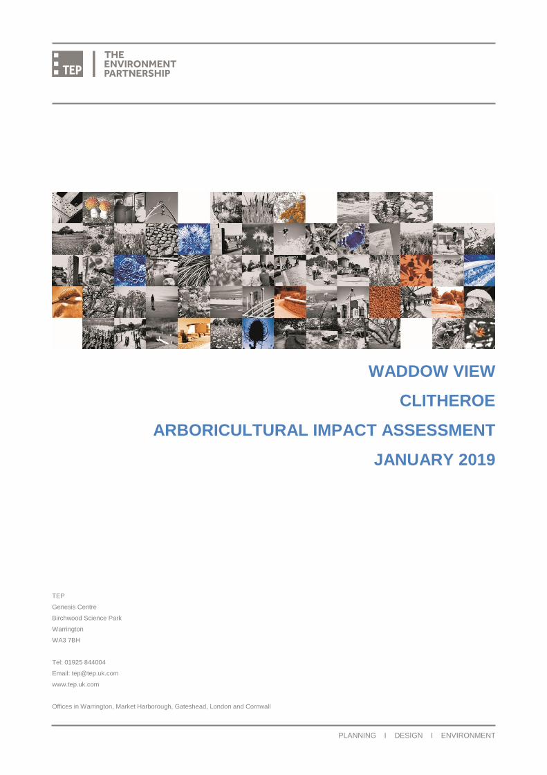
WADDOW VIEW
CLITHEROE
ARBORICULTURAL IMPACT ASSESSMENT
JANUARY 2019
TEP
Genesis Centre
Birchwood Science Park
Warrington
WA3 7BH
Tel: 01925 844004
Email: [email protected]
www.tep.uk.com
Offices in Warrington, Market Harborough, Gateshead, London and Cornwall
PLANNING I DESIGN I ENVIRONMENT
Waddow View Clitheroe Arboricultural Impact Assessment
Document Title Arboricultural Impact Assessment
Prepared for Barratt & David Wilson Homes North West
Prepared by TEP - Warrington
Document Ref 6896.001
Author Robin Grimes
Date January 2019
Checked Angus Blankenstein
Approved Jonathan Smith
Amendment History
Version Date Modified
by
Check /
Approved
by
Reason(s) issue Status
0.1 02/03/18 RMG JGS Approval Draft
1.0 30/01/19 AAB RMG Issue Final
Waddow View Clitheroe Arboricultural Impact Assessment
6896.001 Version 1.0
January 2019
CONTENTS PAGE
Executive Summary .............................................................................................................. 1
1.0 Introduction ............................................................................................................. 2
2.0 The Site and Surroundings ...................................................................................... 3
3.0 Statutory Protection and Guidance .......................................................................... 4
4.0 Tree Population ....................................................................................................... 6
5.0 Impacts of the Proposed Development .................................................................. 10
6.0 Tree Protection Requirements ............................................................................... 12
7.0 Recommendations ................................................................................................ 14
TABLES PAGE
Table 1 Features of possible interest to bats ......................................................................... 5
Table 2 Summary of BS 5837 tree quality categorisation criteria .......................................... 8
Table 3 Arboricultural impacts by quality category ................................................................ 9
Table 4 Arboricultural impacts by quality category .............................................................. 10
Table 5 Recommended tree surgery works ......................................................................... 14
FIGURES PAGE
Figure 1 Site location and approximate boundary (OS Street View ® 1:10 000 scale) .......... 3
Figure 2 View north at T14, T15 and T16 .............................................................................. 6
Figure 3 Lapsed hawthorn hedgerow group G1 .................................................................... 7
Figure 4 Deadwood habitat on failed hawthorn in group G1 .................................................. 7
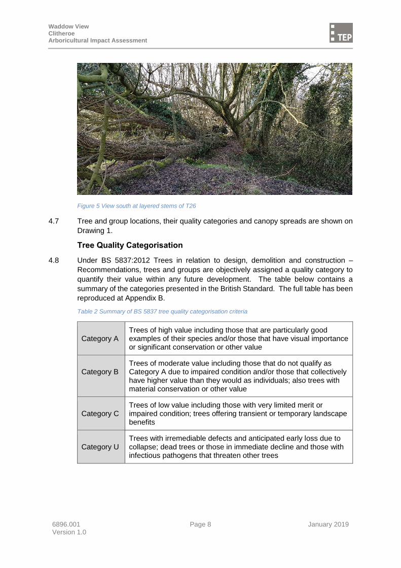
Figure 5 View south at layered stems of T26 ........................................................................ 8
APPENDICES
APPENDIX A: Arboricultural Survey Data
APPENDIX B: Survey Method
DRAWINGS
Drawing 1 - Tree Constraints Plan
Drawing 2 - Tree Removal and Protection Plan
Drawing 3 - Recommended Tree Protection Fencing
Drawing 4 - Above Ground Construction Specification
Waddow View Clitheroe Arboricultural Impact Assessment
6896.001 Page 1 January 2019 Version 1.0
Executive Summary
1. TEP has been commissioned to conduct a survey of the trees at Waddow View in
Clitheroe. This report details the arboricultural impact of developing the site for
residential use, subsequent mitigation recommendations and protective measures.
2. Tree cover is largely native broadleaved species, dominated by common ash, and in
a condition commensurate with the sites farming heritage. Many of the mature ash
are in varying stages of decline due to their age, but exacerbated by their agricultural
setting and ash dieback disease.
3. Based on an objective assessment made in accordance with BS 5837:2012 Trees in
relation to design, demolition and construction – Recommendations, there are 3 high
quality (Category A), 12 moderate quality (Category B), 22 low quality (Category C)
and 9 unsuitable (Category U) trees and groups on or within influencing distance of
the site. 9 hedges were also recorded but not assigned a quality category.
4. A site survey and desktop searches identified no trees on or immediately adjacent to
the site subject to a Tree Preservation Order. No part of the site lies within a
Conservation Area and no veteran trees or ancient woodland are present. The
capacity of trees to support roosting bats should be confirmed by an ecologist prior
to works; arboricultural observations to inform this process are provided in Section 3.
5. Approximately 80 trees recorded as 19 individuals and 4 groups would be removed
to facilitate the development proposals. In addition, approximately 280m of hedgerow
would also be removed.
6. The greatest arboricultural impact of development on this site would be the loss of
the mature hawthorn trees (G1) within the southern section of the site. Their removal
will result in a reduction of ecological values that cannot be replaced in the short to
medium term.
7. Retention of 2 large Category A trees on the southern boundary will be possible with
the implementation of a system of above ground construction; detail of this is covered
in section 7.0.
8. New landscaping proposals are shown on the Landscape Masterplan (not appended
to this report) and indicate a substantial amount of new planting both in the open
areas and within new back gardens. No detailed planting plans were made available
for consideration during this assessment. Provided tree planting occurs in broad
accordance with the Landscape Masterplan it is the recommendation of this report
that mitigation in this form has the potential to result in a temporary reduction in
mature tree cover (estimated at 40 years post-construction) but a long term increase
in both tree quality and diversity.
9. This report constitutes a valid basis for the evaluation of impacts on trees resulting
from the proposed development for a period not exceeding 2 years. After this, it may
be necessary to review survey data and conclusions to ensure reliability. Where the
recommendations of this report have been followed, any future deterioration in tree
condition may not be attributed to the development.
Waddow View Clitheroe Arboricultural Impact Assessment
6896.001 Page 2 January 2019 Version 1.0
1.0 Introduction
1.1 TEP has been commissioned by Barratt & David Wilson Homes North West to
conduct an arboricultural survey of land at Waddow View in Clitheroe. This report
details the arboricultural impact of developing the site, subsequent mitigation
recommendations and protective measures.
1.2 The survey was carried out in February 2018 by means of inspection from ground
level by a qualified Arboricultural Consultant. Trees were assessed in accordance
with BS 5837:2012 Trees in relation to design, demolition and construction –
Recommendations.
1.3 Under the British Standard the assessment of trees is made objectively. The
categorisation method identifies the quality and value of the existing tree stock.
1.4 A topographical survey was used to record the position of trees and vegetation was
provided by the client (drawing reference: 0911-2D_Rev_B). Where the age
distribution and species mix of tree cover was relatively uniform, trees were plotted
as groups. For the purposes of this report it is assumed that the detail on the drawing
is accurate.
1.5 The nature of the soils on site was not assessed during the survey. The possibility
of minor soil movement due to tree root activity cannot be discounted. Prior to the
undertaking of foundation depth calculations any estimated tree locations should be
resolved. Any apparent discrepancy in tree location or queries relating to the location
of species within groups should be discussed with TEP prior to submission.
1.6 A total of 39 individual trees (T1-T39), 7 groups of trees (G1-G7) and 9 hedgerows
(H1-H9) were surveyed and mapped. All arboricultural information recorded during
the survey is presented at Appendix A.
1.7 This report provides the results of the survey and includes the following:
A schedule of all trees and hedges located on, or within influencing
distance of the proposed development site (Appendix A);
An assessment based on BS 5837:2012, of trees in terms of their potential
value within any future development. On the basis of this assessment trees
have been categorised into one of four categories: A, B, C or U
(Appendices A & B);
An assessment, based on BS 5837:2012, of the requirement for protection
of trees during the construction phase (Section 6);
Advice on removal, retention and management of trees (Sections 5 & 7);
A Tree Constraints Plan detailing tree quality categories, canopy spreads
and Root Protection Areas (RPA) for all trees surveyed (Drawing 1); and
A Tree Removal and Protection Plan detailing the development proposals
alongside trees to be retained and removed, temporary tree protection
measures and areas of specialised construction (Drawing 2).

Waddow View Clitheroe Arboricultural Impact Assessment
6896.001 Page 3 January 2019 Version 1.0
2.0 The Site and Surroundings
2.1 The site is located on the north-western perimeter of the town of Clitheroe in
Lancashire. It consists of several pastoral fields divided by ditches, hedgerows and
fences, with individual trees and groups of trees present in various locations.
Vehicular access is possible via two gated farm tracks off Waddington Road to the
north and Back Commons to the south-east.
2.2 The site is bordered to the north by Clitheroe Cemetery, residential properties off
Waddington Road and further fields; to the east by a single field beyond which lies
the exiting built edge of Clitheroe Town; to the south by further residential properties,
Back Commons, and field; and to the west by agricultural land (see Figure 1).
2.3 A public footpath runs through the southern section of the site from Back Commons
to the fields to the west, in a north-west/south-east direction. A connecting public
footpath runs along the western boundary on neighbouring land.
2.4 Weather conditions during the survey were clear skies, bright sun and high winds.
Inspection of trees was restricted in some cases by dense vegetation or their location
on third party land. These trees were surveyed insofar as was possible from
accessible areas of the site and from the public highway1.
Figure 1 Site location and approximate boundary (OS Street View ® 1:10 000 scale)
Contains OS data © Crown copyright and database right 2016
Development Proposals
2.5 The proposed development includes the construction of 243 new homes with
associated infrastructure comprising new roads, footpaths; public open space and
areas of soft landscaping. The new road network will be fed from Waddington Road
in the north-east corner at the site of an existing agricultural gated entrance. The
public footpath that runs through the site at present will be maintained along the same
alignment.
2.6 Detail of the proposals is shown on Drawing 2 and is based on the Proposed Layout
Plan (drawing reference: DWH063 PL01 P8) supplied by APD Limited.
1 Survey restrictions are noted in Appendix A
Waddow View Clitheroe Arboricultural Impact Assessment
6896.001 Page 4 January 2019 Version 1.0
3.0 Statutory Protection and Guidance
National Planning Policy Framework (NPPF)
3.1 The National Planning Policy Framework (NPPF) is a material consideration in the
planning process and promotes a presumption in favour of sustainable development.
In terms of the natural environment, development should minimise impacts on
biodiversity and provide a net gain in biodiversity where possible.
3.2 The NPPF assumes protection of all ancient woodland and veteran trees unless it
can be clearly demonstrated that the need for, or benefits of, development outweigh
the loss. In this respect ancient woodland is defined as an area which has been
wooded continuously since at least 1600 AD and a veteran as a tree of exceptional
value for wildlife, in the landscape, or culturally because of its great age, size or
condition.
3.3 On this site there are no ancient woodland or veteran trees. Hawthorn trees forming
group G1 are very old and contain features commonly associated with veteran trees.
Based on their overall condition however, they fail to meet the full criteria required to
designate them as true veterans, although they do poses increased ecological value
due to the niche deadwood habitats they provide.
Tree Preservation Orders & Conservation Area Designations
3.4 Where it is considered expedient to do so, local authorities can create Tree
Preservation Orders (TPO) to protect the amenity value conferred to a location by a
tree or group of trees. Where a TPO is in force, lopping, topping, felling, uprooting or
wilful damage caused to a tree is prohibited and such actions may be prosecuted and
incur an unlimited fine. Works to TPO protected trees must only be undertaken with
the written consent of the local authority.
3.5 Section 211 of The Town and Country Planning Act 1990 (TCPA) relates to the
preservation of trees in Conservation Areas. Under Section 211 anyone proposing
to remove, uproot or destroy any tree within a Conservation Area is required to give
the local planning authority six weeks’ prior notice (a “section 211 notice”). During
this period the Council may consider serving a Tree Preservation Order to prevent
the proposed work from being undertaken.
3.6 Exceptions from the requirement to give a Section 211 notice are set out in The Town
and Country Planning (Tree Preservation) (England) Regulations 2012. A person
does not have to give the local planning authority six weeks’ prior notice for, amongst
other reasons, work to trees so far as such work is necessary to implement a planning
permission (other than an outline planning permission).
3.7 A check was undertaken with Ribble Valley Borough Council on 2nd March 2018.
David Hewitt confirmed that no trees and tree groups on or immediately adjacent to
the site were subject to Tree Preservation Orders and that the site does not lie within
a Conservation Area.
Waddow View Clitheroe Arboricultural Impact Assessment
6896.001 Page 5 January 2019 Version 1.0
Protected Species – Bats
3.8 Mature trees often contain cavities, crevices and hollows, which are a potential
habitat for roosting bats. Bats are afforded protection under Schedule 5 of the Wildlife
and Countryside Act 1981 (as amended), as well as under Schedule 2 of the
Conservation of Species and Habitats Regulations 2010, and as such causing
damage to a bat roost constitutes an offence.
3.9 A preliminary ground level appraisal of the wildlife habitat value of each tree was
undertaken by a trained layperson as part of the arboricultural survey. Where
observations incidental to the primary purpose of tree surveying have a possible
interest to bats they are recorded below. This information should not be treated as
comprehensive bat survey. However, an arboricultural view on the likely internal
structure of any cavity or crevice may usefully inform a ground based bat habitat
assessment. The extent of any bat roost potential in trees should be determined by
the project ecologist.
Table 1 Features of possible interest to bats
Tree survey reference Feature/s of note
T4 Large branch failure at 4.5m with open wound, large decay pockets
3.10 If any works are to be carried out to the tree identified in the table above, reference
should be made to the results and recommendations of a competent bat assessment
prior to commencement.
3.11 If the presence of a bat roost is suspected whilst undertaking works on any trees on
site, operations must be halted until a licensed bat handler or ecologist can provide
advice.
Protected Species - Birds
3.12 Trees are a potential habitat for nesting birds, which (as well as their nests and eggs)
are protected under the Wildlife and Countryside Act 1981 (as amended). This makes
it an offence to intentionally or recklessly, damage or destroy an active nest or any
part thereof.
3.13 Due to the suitability of the trees within the survey boundary for nesting birds, all tree
work should ideally avoid the bird nesting season (March to August, inclusive).
3.14 If this is not possible then a detailed inspection of each tree should be undertaken by
a qualified ecologist immediately prior to the arboricultural works. Should an active
nest be found (being built, containing eggs or chicks), any work likely to affect the
nest must be halted until an ecologist can provide advice.
Waddow View Clitheroe Arboricultural Impact Assessment
6896.001 Page 6 January 2019 Version 1.0
4.0 Tree Population
4.1 39 individual trees (T1-T39), 7 groups of trees (G1-G7) and 9 hedgerows (H1-H9)
were recorded within influencing distance of the site. A schedule of all trees and
groups in terms of species, condition, age, management recommendations and BS
5837:2012 quality categories is provided at Appendix A.
4.2 Tree cover is largely native broadleaved species, dominated by common ash, and in
a condition commensurate with the sites farming heritage. Many of the mature ash
are in varying stages of decline due to their age and prevalence of ash dieback in the
local area, but exacerbated by ground compaction and physical abrasion from cattle.
Figure 2 View north at T14, T15 and T16
4.3 Across the southern half of the site and forming the boundary of one of the fields is a
lapsed hedgerow that now forms a linear group of very old hawthorn trees in varying
condition. They are all mature trees, some with very large stem diameters for this
species. A high proportion of trees in the group are multi-stemmed with a gnarly form
and snapped out limbs, have evidence of brown rot decay and dead wood, features
typical of veteran trees. However, some of the trees are in decline and some have
failed stems with the crowns lying in the adjacent fields. This arboricultural feature
no longer functions as hedgerow as it is not stock proof and it would be difficult to
bring back into hedgerow management without extensive new planting but it does
provide valuable niche habitat and connectivity across the wider site.
4.4 In the southwest corner of the site, a row of trees (T7 to T11) are located along the
edge of Back Commons which lies at a slightly elevated level. T7 and T9 are both
mature common alder and particularly good examples of their species. T8 and T10
are also alder; T8 has a large stem cavity running from the base up into the main
stem and has a limited safe useful life expectancy; T10 has failed and is lying in the
field to the north.
Waddow View Clitheroe Arboricultural Impact Assessment
6896.001 Page 7 January 2019 Version 1.0
Figure 3 Lapsed hawthorn hedgerow group G1
Figure 4 Deadwood habitat on failed hawthorn in group G1
4.5 A ditch runs across the site from the north-west to the south-east. At the southernmost end, trees include mature ash (T1 and T4) and self-set ash and horse chestnut (T2, T3 and T5). T1 is one of the largest trees on the site with a broad spreading crown and 3 large limbs; T4 is also an ash but has a large open cavity on the northern stem which is in danger of collapse.
4.6 At the northernmost end of the ditch a large goat willow (T26) spreads out with long
horizontal stems that have layered. It provides good habitat and although has a spreading and unkempt form, still has a long life expectancy.
Waddow View Clitheroe Arboricultural Impact Assessment
6896.001 Page 8 January 2019 Version 1.0
Figure 5 View south at layered stems of T26
4.7 Tree and group locations, their quality categories and canopy spreads are shown on
Drawing 1.
Tree Quality Categorisation
4.8 Under BS 5837:2012 Trees in relation to design, demolition and construction –
Recommendations, trees and groups are objectively assigned a quality category to
quantify their value within any future development. The table below contains a
summary of the categories presented in the British Standard. The full table has been
reproduced at Appendix B.
Table 2 Summary of BS 5837 tree quality categorisation criteria
Category A
Trees of high value including those that are particularly good examples of their species and/or those that have visual importance or significant conservation or other value
Category B
Trees of moderate value including those that do not qualify as Category A due to impaired condition and/or those that collectively have higher value than they would as individuals; also trees with material conservation or other value
Category C
Trees of low value including those with very limited merit or impaired condition; trees offering transient or temporary landscape benefits
Category U
Trees with irremediable defects and anticipated early loss due to collapse; dead trees or those in immediate decline and those with infectious pathogens that threaten other trees
Waddow View Clitheroe Arboricultural Impact Assessment
6896.001 Page 9 January 2019 Version 1.0
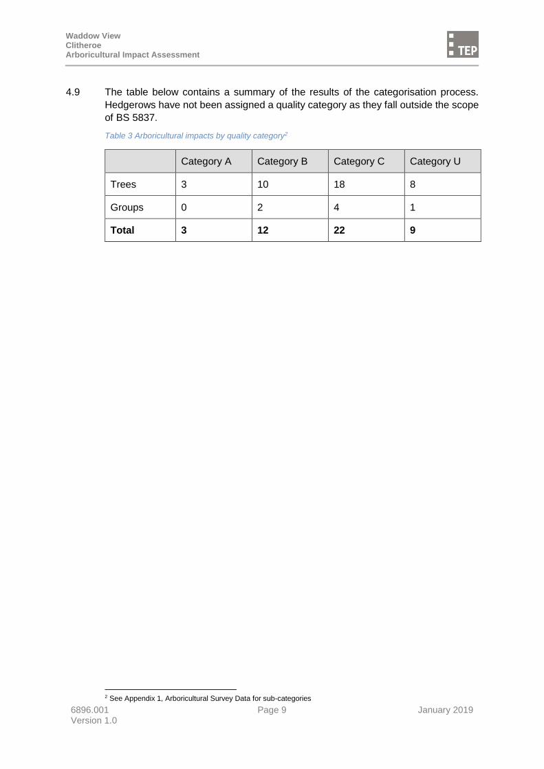
4.9 The table below contains a summary of the results of the categorisation process.
Hedgerows have not been assigned a quality category as they fall outside the scope
of BS 5837.
Table 3 Arboricultural impacts by quality category2
Category A Category B Category C Category U
Trees 3 10 18 8
Groups 0 2 4 1
Total 3 12 22 9
2 See Appendix 1, Arboricultural Survey Data for sub-categories
Waddow View Clitheroe Arboricultural Impact Assessment
6896.001 Page 10 January 2019 Version 1.0
5.0 Impacts of the Proposed Development
5.1 This section describes the number and quality of trees that would be removed in order
to facilitate the development proposals, and those that can be retained. This is the
result of an assessment based on the proposed site plan and discussions with the
client regarding their application strategy.
5.2 The table below shown the effects of the proposals on trees in terms of their BS 5837
quality categorisation. Features shown with a (*) are located on or beyond the site
boundary and are likely to be under full or part third party ownership.
Table 4 Arboricultural impacts by quality category3
Category A Category B Category C Category U Hedges
Features that would be removed
-
T20; T25; T38; G1
T29; T34; T35; T36; T37; T38; T39; G6; G7
T8; T10; T14; T15*; T16*; T19; T30; G3
H5(82m); H6(62m); H7(114m); H9(26m);
Total 0 trees
0 groups
3 trees
1 group
7 trees
2 groups
7 trees
1 group
4 hedges
(284m)
Features that would be retained
T7; T9; T28
T1; T2; T5; T12; T13; T17* T23*; G2
T3; T11; T18*; T21; T22; T24; T26; T27; T31; T32*; G4; G5
T4
H1(95m); H2(50m); H3(233m); H4(78m); H5(345m); H8(212m)
Total 3 trees
0 groups
7 trees
1 group
10 trees
2 groups
1 tree
0 groups
6 hedges
(1013m)
5.3 Approximately 80 trees recorded as 17 individuals and 4 groups would be removed
to facilitate the development proposals. In addition, approximately 280m of hedgerow
would also be removed.
5.4 The majority of tree removals are associated with the outgrown hedgerow, group G1,
estimated to contain around 50 individual hawthorn trees.
5.5 Along the western boundary 5 trees within the field boundary hedgerow would require
removal due to the incursion of new roads or hard surfacing and proximity to new
buildings due to their poor condition. 2 of these (T15 and T16) are thought to be
located on third party land and the applicant would need to demonstrate control over
these trees before tree removal occurs.
3 See Appendix 1, Arboricultural Survey Data for sub-categories
Waddow View Clitheroe Arboricultural Impact Assessment
6896.001 Page 11 January 2019 Version 1.0
5.6 In order to upgrade current access into the site from Waddington Road, all 8 trees
and both groups in this location would require removal (T33 to T39, G6 and G7). This
would be to facilitate the road widening and visibility splays.
5.7 Ash trees T1 and T4 will require some crown management to ensure their long term
contribution to the development. T1 will require a crown reduction by up to 2m to
reduce the end weight of the long limbs. T4 should be reduced back to a 4m habitat
pole to avoid large stem failure at the existing decay cavity. T17 will also require
crown raising away from the proposed play area.
5.8 A high proportion of ash trees are also in decline. This is possibly due to the
prevalence of ash dieback in the area. Any ash trees retained as part of the
development should be monitored every 2 years to ensure their current condition is
suitable for the context of new development. No new ash trees should be planted.
5.9 Fencing to protect the retained trees will be necessary. This will reduce the useable
area for works and storage of materials during development.
5.10 Where planning permission is granted, the retention schedule shown above and on
Drawing 2 would normally form a part of that permission. Any change to this schedule
may therefore require an application to vary the consent.
Waddow View Clitheroe Arboricultural Impact Assessment
6896.001 Page 12 January 2019 Version 1.0
6.0 Tree Protection Requirements
6.1 The following information sets out the primary considerations in determining the
requirement for tree protective measures and in the assessment of development
impact.
Root Protection Areas
6.2 As per BS 5837:2012, the Root Protection Area (RPA) is calculated using each tree’s
diameter at 1.5 metres4 and represents the minimum area around each tree that must
be left undisturbed to ensure its survival.
6.3 Tree roots typically spread two times the width of the crown, although this figure may
be significantly increased for certain species and where specific ground conditions
are present. The majority of tree roots are found in the top 600mm of soil and most
of the fine roots that absorb water and nutrients are found close to the surface.
6.4 The morphology of roots is influenced by past and present site conditions (including
roads, buried structures and underground services), soil type, topography and
drainage. This means that a tree’s roots may not be uniform in extent and the RPA
may not be a circular area centred on the tree stem.
6.5 On this site, likely barriers and limitations to root growth include roads and hard
surfacing which have been constructed within the lifetime of adjacent trees. It is likely,
although unknown for certain, that previous hard surfacing instillation resulted in
some degree of root severance. Roots are unlikely to be absent in all these areas
but where unfavourable conditions exist, growth will certainly be impeded.
6.6 The RPA has been adjusted or offset where appropriate to most accurately represent
the likely spread of roots for each individual tree5.
Ground Contamination
6.7 Storage areas for liquids such as fuels, oil or paint should not be located within 10m
of any tree due to the risk of soil contamination caused by accidental spillage.
6.8 Particular care must be taken when working on or close to sloping ground to avoid
unintentional runoff into the rooting area of retained trees.
Underground Utility Issues
6.9 No detailed utility drawings were provided and no assessment has been made of the
juxtaposition of tree roots and the likely location of new services.
6.10 Where the installation of services within the Root Protection Area of retained trees is
unavoidable, appropriate work methods will be required to ensure the safe long-term
survival of those trees. This process will require additional consultation with a
qualified Arboricultural Consultant and is likely to be more expensive than
conventional trench installation.
4 Refer to Appendix A for RPA area calculations 5 See Drawing 1 for RPA shapes
Waddow View Clitheroe Arboricultural Impact Assessment
6896.001 Page 13 January 2019 Version 1.0
Ground Level Changes
6.11 A rise or reduction in soil level can have major implications on the longevity and health
of the trees. Minor changes (up to 100mm) can be tolerated in some cases but is
heavily dependent on tree species, condition and growing environment.
6.12 Existing ground levels within the Root Protection Area should be maintained. The
advice of a qualified Arboricultural Consultant should be sought if level changes are
required.
Drainage & Storm Water Run-off Issues
6.13 Drainage and storm water run-off requires due consideration to prevent excessive
and/or polluted run-off into the rooting area of trees to be retained.
Waddow View Clitheroe Arboricultural Impact Assessment
6896.001 Page 14 January 2019 Version 1.0
7.0 Recommendations
Tree Work
7.1 In addition to the tree removals proposed, the tree surgery operations presented
below are recommended.
Table 5 Recommended tree surgery works
Tree survey reference Tree works description
T4 Reduce tree to habitat pole for safety reasons
T17 Crown raise to create 4m clearance from ground level on eastern side of canopy
T1, T12, T13, T14, T27, T28 Monitor for ash dieback on a biennial basis
7.2 All tree surgery work should be carried out by a qualified contractor in accordance
with British Standard 3998:2010 Tree work – Recommendations.
Protective Fencing and Exclusion Zones
7.3 Site-wide tree protection measures will be required during construction to deliver the
tree retention schedule presented in this report. This will include temporary protective
barrier fencing to demarcate a Construction Exclusion Zone (CEZ) around retained
trees. This must be put in place prior to the commencement of any development
works, including bringing machinery or materials onto site, the erection of site huts or
demolition.
7.4 The CEZ should protect both tree roots and branches and should be designed to
incorporate canopy spread where appropriate. All of the CEZ should be protected
throughout the construction process by either an approved working methodology,
ground protection, or protective fencing.
7.5 Protective fencing alignment is shown on Drawing 2 and assumes that all trees
identified for removal have been felled prior to installation.
7.6 The fencing must be fixed into the ground to withstand accidental impact from
machinery and to ensure that a sufficient protective area is maintained. Details of the
recommended protective fencing are shown on Drawing 3.
7.7 A weatherproof notice identifying the Construction Exclusion Zone must be fixed to
each fencing panel. An example notice is shown on Drawing 3.

Waddow View Clitheroe Arboricultural Impact Assessment
6896.001 Page 15 January 2019 Version 1.0
7.8 Protective fencing around trees T7 and T9 should be aligned as shown on Drawing
2. When it is time to construct the footpath which passes through the RPA of these
trees the fencing should be realigned to provide working space and the footway
installed using a system of above ground construction. Detail of this is shown on
Drawing 4.
7.9 Any alteration to the fencing alignment to allow for approved activities should only be
made in agreement with the council’s Arboricultural Officer.
7.10 The protective fencing must not be removed until the physical construction phase has
been completed and all vehicles have been removed from site, to the satisfaction of
the council’s Arboricultural Officer.
Mitigation for the removal of trees
7.11 The National Planning Policy Framework (NPPF) is a material consideration in the
planning process and promotes a presumption in favour of sustainable development.
In terms of the natural environment, development should minimise impacts on
biodiversity and provide a net gain in biodiversity where possible.
7.12 In respect of trees, a sustainable development will be one whereby the total number,
value or function provided by trees is maintained or increased or where the long-term
prospects of the existing tree stock can be substantially improved. Net gains in
biodiversity may be demonstrated where the number of tree species, variety of tree
ages or range of niche habitats can be increased. Native, old, large or dead trees are
likely to have a relatively significant impact on a scheme's environmental credentials,
as will the connectivity of trees, hedges and woodland.
7.13 Approximately 80 trees would be removed as part of the development proposal, the
majority of these contained within a single group of moderate quality mature
hawthorn.
7.14 New landscaping proposals are shown on the Landscape Masterplan (not appended
to this report) and indicate a substantial amount of new planting will be
accommodated both in the open areas and within new back gardens. No detailed
planting plans were made available for consideration in this assessment.
7.15 The majority of larger tree that would be removed are ash and alder species. Suitable
replacements for these include other medium to large growing natives such as small-
leaved lime (Tilia cordata), English oak (Quercus robur), sessile oak (Quercus
petraea), common beech (Fagus sylvatica) and hornbeam (Carpinus betulus) which
could be planted in the larger areas of open space. Smaller ornamental trees should
be incorporated within new gardens to increase the overall diversity of tree species,
size and age across the site.
7.16 It is not recommended to plant ash due to the prevalence of ash dieback across the
site and affecting an increasing portion of the national ash population.
7.17 Aftercare is vital to the survival of newly planted trees. Provision should be made for
a minimum of two years' maintenance of newly planted trees and include watering,
formative pruning and the checking of tree ties and stakes.
Waddow View Clitheroe Arboricultural Impact Assessment
6896.001 Page 16 January 2019 Version 1.0
7.18 Based on the landscaping proposals shown on the Landscape Masterplan it is the
recommendation of this report that mitigation in the form of tree planting has the
potential to result in a temporary reduction in mature tree cover (estimated at 40 years
post-construction) but a long term increase in both tree quality and diversity.
7.19 The extent of mitigation planting will ultimately be determined in agreement with the
LPA.
Post Construction Tree Care
7.20 Hazard recommendations are based on observations at the time of survey. Trees
are dynamic living organisms whose structure is constantly changing. Even those in
good condition can suffer from damage or stress. Following site development,
regular (annual or biennial) inspections of all retained trees should be undertaken by
a qualified Arboricultural Consultant.
Waddow View Clitheroe Arboricultural Impact Assessment
6896.001 Appendices January 2019 Version 1.0
APPENDIX A: Arboricultural Survey Data
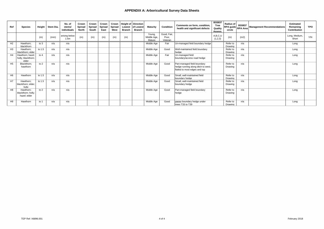
APPENDIX A: Arboricultural Survey Data Sheets
Surveyor Robin Grimes
Date 23.02.18
Town Clitheroe
Site Waddow View
Dwg Ref D6896.101
Ref Species Height Stem Dia.
No. of
stems/
individuals
Crown
Spread
North
Crown
Spread
South
Crown
Spread
East
Crown
Spread
West
Height of
Lowest
Branch
Direction
of Lowest
Branch
Maturity ConditionComments on form, condition,
health and significant defects
BS5837
Tree
Quality
Assess.
Radius of
RPA guide
circle
BS5837
RPA AreaManagement Recommendations
Estimated
Remaining
Contribution
TPO
(m) (mm)arising below
1.5m(m) (m) (m) (m) (m)
Young,
Middle Age,
Mature
Good, Fair,
Poor,
Veteran
A,B,C,U
(1,2,3)(m) (m2)
Long, Medium,
ShortY/N
Trees
T1 Common ash 13.5 976 4.0 11.0 8.5 9.0 9.5 0.5 NE Mature Good Located in H2; Stem trifurcates
into sub-stems at 1.5m; some
included stem unions; good crown
form and vigour with slight
weighting to north over field; ditch
near base of stem
B,1,2 11.7 430.9 Long
T2 Horse chestnut 6.0 310 1.0 4.0 4.0 4.0 4.0 2.0 N Middle Age Good Good form and vigour; no
significant defects
B,1 3.7 43.5 Long
T3 Common ash 8.0 120 1.0 1.0 1.0 1.0 1.0 0.5 S Young Good Self-set; no significant defects C,1 1.4 6.5 Long
T4 Common ash 13.0 870 1.0 9.0 8.0 11.0 7.5 5.0 E Mature Poor Large branch failure at 4.5m with
open wound, large decay pockets
and several Daeldinia concentrica
fungal fruiting bodies present;
potential to shed more large
branches
U 0.0 0.0 Short
T5 Common ash 10.0 280 1.0 5.0 3.0 4.0 3.0 2.0 N Middle Age Good Minor stem lean to east; no
significant defects
B,1 3.4 35.5 Long
T6 Common ash 11.0 397 2.0 6.0 5.0 5.0 5.0 4.0 NE Middle Age Good Bifurcate at 1m with minor stem
inclusion; large bark wound to
south has partially occluded; no
significant defects
B,1 4.8 71.3 Long
T7 Common alder 15.5 820 1.0 8.0 8.0 7.0 7.0 6.0 NW Mature Good Excellent form and vigour; growing
on edge of access track with field
to south at lower level; minor dead
wood; no significant defects
A,1 9.8 304.2 Long
T8 Common alder 13.0 700 1.0 8.0 7.0 5.0 7.0 2.0 W Mature Poor Very large basal cavity with
extensive decay present; cavity
extends up and into tree some
way; moderate crown vigour
U 0.0 0.0 Short
T9 Common alder 13.0 610 1.0 6.0 6.0 6.0 6.0 4.0 N Mature Good Pronounced buttress flare; some
epicormic growth but dense
vegetation in H4 also growing
around base; good crown form
and vigour
A,1 7.3 168.3 Long
T10 Common alder 15.0 550 1.0 0.0 0.0 0.0 0.0 Mature Dead Dead stem lying on floor to north
east
U 0.0 0.0 Short
T11 Grey willow 7.0 418 4.0 6.0 5.0 7.0 5.0 1.5 E Mature Fair Multi-stemmed from base with
sprawling stems and crown
C,1 5.0 79.1 Medium
T12 Common ash 6.0 180 1.0 0.5 3.0 2.0 2.5 3.0 E Middle Age Good Growing under crown of T13 so
highly asymmetric and weighted to
south; good vigour
C,1,2 2.2 14.7 Long
T13 Common ash 9.0 470 1.0 5.5 5.5 5.5 5.5 4.0 SW Middle Age Fair Good form with slightly reduced
vigour; forms part of tree line
within hedgerow; good landscape
value
B,1,2 5.6 99.9 Medium
T14 Common ash 9.0 580 1.0 3.0 5.0 5.0 2.0 3.0 E Mature Poor Third party tree located in adjacent
ditch; significant die back and
reduced vigour
U 0.0 0.0 Short
TEP Ref: X6896.001 1 of 4 February 2018
APPENDIX A: Arboricultural Survey Data Sheets
Ref Species Height Stem Dia.
No. of
stems/
individuals
Crown
Spread
North
Crown
Spread
South
Crown
Spread
East
Crown
Spread
West
Height of
Lowest
Branch
Direction
of Lowest
Branch
Maturity ConditionComments on form, condition,
health and significant defects
BS5837
Tree
Quality
Assess.
Radius of
RPA guide
circle
BS5837
RPA AreaManagement Recommendations
Estimated
Remaining
Contribution
TPO
(m) (mm)arising below
1.5m(m) (m) (m) (m) (m)
Young,
Middle Age,
Mature
Good, Fair,
Poor,
Veteran
A,B,C,U
(1,2,3)(m) (m2)
Long, Medium,
ShortY/N
T15 Common ash 10.0 550 1.0 5.0 5.0 7.5 3.0 4.5 W Mature Poor Third party tree located in adjacent
ditch; hollow stem from base; die
back and reduced vigour in crown
U 0.0 0.0 Short
T16 Common ash 8.0 500 1.0 4.5 2.5 3.5 4.5 2.5 W Mature Poor Third party tree located in adjacent
ditch; significant die back and
reduced vigour
U 0.0 0.0 Short
T17 Common ash 13.0 720 1.0 8.0 8.0 8.0 8.0 4.0 W Mature Fair Third party tree located adjacent
ditch; some minor branch tip die
back and dead wood
B,1,2 8.6 234.5 Medium
T18 Common ash 9.0 180 1.0 3.0 3.5 4.0 2.5 2.0 S Middle Age Good Third party tree located adjacent
ditch; growing under T17 and T19
with some minor suppression
C,1,2 2.2 14.7 Long
T19 Common ash 16.5 810 1.0 8.0 7.0 9.0 6.0 6.0 N Mature Poor In severe decline U 0.0 0.0 Short
T20 Common alder 8.0 600 1.0 5.0 4.0 6.0 3.5 1.5 W Mature Fair Large burred bole to 0.5m
(adaptation to constant grazing
around base of tree); small crown
with signs of minor reduction in
vigour
B,1,2 7.2 162.9 Long
T21 Common
whitebeam
8.0 250 1.0 3.0 3.5 1.0 3.5 2.0 S Middle Age Good Third party tree on boundary; stem
bifurcates at 3m; good crown form
and vigour
C,1 3.0 28.3 Long
T22 Common ash 10.0 260 1.0 3.0 4.5 3.0 4.0 2.5 E Middle Age Good Kinked stem at 3m; crown
weighted south
C,1 3.1 30.6 Long
T23 Hawthorn 7.0 340 1.0 3.0 3.0 3.0 3.0 1.0 W Mature Good Third party tree with crown
overhanging site by up to 1m;
broken branches to south; minor
basal cavity; fused branches
within crown
B,1 4.1 52.3 Long
T24 Common ash 9.0 250 1.0 2.0 2.0 2.0 2.0 5.0 S Middle Age Good Self-set in H7; good form and
vigour; no significant defects
C,1 3.0 28.3 Long
T25 Common alder 9.0 620 1.0 5.0 6.5 6.5 5.0 3.0 S Mature Good Stem bifurcates at 2m; good
crown form and vigour
B,1 7.4 173.9 Long
T26 Grey willow 8.0 777 4.0 5.0 9.0 8.0 4.0 1.0 S Mature Good Layered, sprawling stems along
surface from multi-stemmed bole;
good crown vigour; quite a wide,
sprawling tree
C,1 9.3 272.9 Long
T27 Common ash 10.0 520 1.0 6.0 6.0 6.0 6.0 4.0 S Mature Fair Good form; ivy clad stem; slightly
reduced vigour with minor shoot
tip die back
C,1 6.2 122.3 Long
T28 Common ash 10.0 350 1.0 5.0 5.0 5.0 5.0 4.0 S Middle Age Good Third party tree adjacent ditch; ivy
clad stem; good form
A,1 4.2 55.4 Long
T29 Common ash 11.0 450 1.0 6.0 6.0 6.0 6.0 2.5 S Middle Age Fair Third party tree located adjacent
ditch; ivy clad stem and in lower
crown; slightly reduced vigour and
shoot die back and broken
branches
C,1 5.4 91.6 Long
T30 Common ash 10.0 600 1.0 6.0 6.0 6.0 6.0 3.0 S Mature Poor In severe decline U 0.0 0.0 Short
T31 Common ash 13.0 320 1.0 3.0 4.0 2.0 3.0 5.0 S Middle Age Fair Third party tree adjacent ditch; tall,
thin crown
C,1 3.8 46.3 Medium
T32 Hawthorn 3.0 210 1.0 1.0 1.0 2.0 1.0 0.5 W Middle Age Fair Small, shrubby tree densely ivy
clad
C,1 2.5 20.0 Medium
T33 English elm 16.0 440 1.0 4.0 4.0 2.5 5.0 6.0 N Middle Age Good Boundary/highway tree on edge of
footpath and field; upper crown
has slightly upright form with good
crown vigour
B,1,2 5.3 87.6 Long
TEP Ref: X6896.001 2 of 4 February 2018
APPENDIX A: Arboricultural Survey Data Sheets
Ref Species Height Stem Dia.
No. of
stems/
individuals
Crown
Spread
North
Crown
Spread
South
Crown
Spread
East
Crown
Spread
West
Height of
Lowest
Branch
Direction
of Lowest
Branch
Maturity ConditionComments on form, condition,
health and significant defects
BS5837
Tree
Quality
Assess.
Radius of
RPA guide
circle
BS5837
RPA AreaManagement Recommendations
Estimated
Remaining
Contribution
TPO
(m) (mm)arising below
1.5m(m) (m) (m) (m) (m)
Young,
Middle Age,
Mature
Good, Fair,
Poor,
Veteran
A,B,C,U
(1,2,3)(m) (m2)
Long, Medium,
ShortY/N
T34 Common ash 9.0 280 1.0 3.0 5.0 5.0 3.0 2.0 S Middle Age Fair Boundary/highway tree on edge of
footpath and field; weighted crown
to south and east; severe kink in
lower stem at 0.5m
C,1,2 3.4 35.5 Medium
T35 Common ash 6.0 140 1.0 2.0 3.0 3.0 3.0 2.0 S Middle Age Fair Boundary/highway tree on edge of
footpath and field; weighted crown
to south and east; minor bark
damage with good occlusion wood
C,1,2 1.7 8.9 Medium
T36 Common ash 10.0 210 1.0 3.0 2.0 3.0 2.5 3.0 SW Middle Age Good Boundary/highway tree on edge of
footpath and field; stem abutted up
to footpath; good crown form and
vigour
C,1,2 2.5 20.0 Long
T37 Common ash 10.0 210 1.0 2.5 2.5 3.5 2.5 3.0 E Middle Age Good Boundary/highway tree on edge of
footpath and field; stem abutted up
to footpath; good crown form and
vigour
C,1,2 2.5 20.0 Long
T38 Common ash 9.0 220 1.0 3.0 2.5 3.5 2.5 3.0 W Middle Age Fair Boundary/highway tree on edge of
footpath and field; stem abutted up
to footpath; small burrs and
cankers in crown
C,1,2 2.6 21.9 Medium
T39 Common ash 12.0 390 3.0 5.0 5.0 5.0 6.0 3.0 SW Middle Age Good Boundary/highway tree on edge of
footpath and field; multi-stemmed
at 1m where wooden fence has
been consumed by tree; good
vigour
C,1,2 4.7 68.8 Long
Groups
G1 Hawthorn to 7 to 450 c. 50 Mature Fair Outgrown hedge now comprising
mature hawthorn trees: with
decayed stems; broken branches;
leaning crowns; and small cavities;
some in decline, some with
veteran characteristics; good
boundary feature but would
struggle to bring back into full
hedgerow management; not stock
proof and very unkempt in places
B,2,3 Refer to
Drawing
n/a Medium
G2 Common alder to 11 to 450 2.0 Middle Age Good Third party trees adjacent ditch; 2
trees forming 1 crown; good form
and vigour
B,1,2 Refer to
Drawing
n/a Long
G3 Common alder to 10 to 450 2.0 Middle Age Poor Both trees in decline U Refer to
Drawing
n/a Short
G4 Common ash to 9 to 350 5.0 Middle Age Good Third party boundary trees;
unkempt form
C,2 Refer to
Drawing
n/a Long
G5 Goat willow to 6 to 200 c. 20 Middle Age Fair Sprawling self-set regen growth
emanating from T26
C,2 Refer to
Drawing
n/a Long
G6 Hawthorn; elder to 7 to 80 7.0 Young Fair Shrubby, self-set trees under T33
and T34
C,2 Refer to
Drawing
n/a Long
G7 Sycamore;
common ash;
hawthorn
to 9 to 290 3.0 Middle Age Good 3 trees growing together on edge
of stone wall and gate; ivy clad
stems; leaning stems; good crown
vigour
C,2 Refer to
Drawing
n/a Long
Hedges
H1 Hawthorn to 1 n/a n/a Middle Age Good Well-maintained field boundary
hedge
Refer to
Drawing
n/a Long
TEP Ref: X6896.001 3 of 4 February 2018
APPENDIX A: Arboricultural Survey Data Sheets
Ref Species Height Stem Dia.
No. of
stems/
individuals
Crown
Spread
North
Crown
Spread
South
Crown
Spread
East
Crown
Spread
West
Height of
Lowest
Branch
Direction
of Lowest
Branch
Maturity ConditionComments on form, condition,
health and significant defects
BS5837
Tree
Quality
Assess.
Radius of
RPA guide
circle
BS5837
RPA AreaManagement Recommendations
Estimated
Remaining
Contribution
TPO
(m) (mm)arising below
1.5m(m) (m) (m) (m) (m)
Young,
Middle Age,
Mature
Good, Fair,
Poor,
Veteran
A,B,C,U
(1,2,3)(m) (m2)
Long, Medium,
ShortY/N
H2 Hawthorn;
blackthorn
to 3 n/a n/a Middle Age Fair Un-managed field boundary hedge Refer to
Drawing
n/a Long
H3 Hawthorn;
blackthorn; elder
to 1.5 n/a n/a Middle Age Good Well-maintained field boundary
hedge
Refer to
Drawing
n/a Long
H4 Hawthorn; hazel;
holly; blackthorn;
elder
to 4 n/a n/a Middle Age Fair Un-managed field
boundary/access road hedge
Refer to
Drawing
n/a Long
H5 Blackthorn;
hawthorn
to 2 n/a n/a Middle Age Good Part-managed field boundary
hedge running along ditch to west;
flailed to most edges and top
Refer to
Drawing
n/a Long
H6 Hawthorn to 1.5 n/a n/a Middle Age Good Small, well-maintained field
boundary hedge
Refer to
Drawing
n/a Long
H7 Hawthorn;
blackthorn; elder;
holly
to 1.5 n/a n/a Middle Age Good Small, well-maintained field
boundary hedge
Refer to
Drawing
n/a Long
H8 Hawthorn;
blackthorn; holly;
hazel; elder
to 2 n/a n/a Middle Age Good Part-managed field boundary
hedge
Refer to
Drawing
n/a Long
H9 Hawthorn to 1 n/a n/a Middle Age Good gappy boundary hedge under
trees T33 to T39
Refer to
Drawing
n/a Long
TEP Ref: X6896.001 4 of 4 February 2018
Waddow View Clitheroe Arboricultural Impact Assessment
6896.001 Appendices January 2019 Version 1.0
APPENDIX B: Survey Method
APPENDIX B: SURVEY METHOD
Revision F TEP, Genesis Centre, Birchwood Science Park, Warrington, WA3 7BH
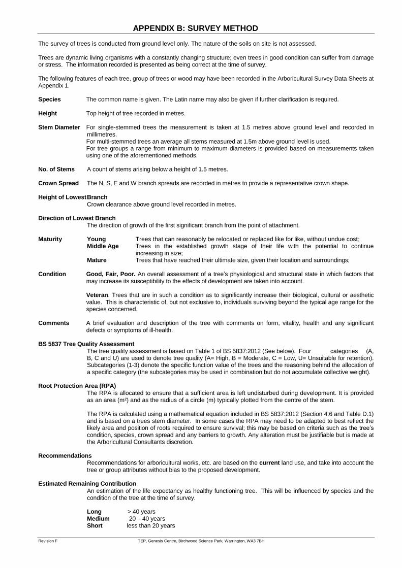
The survey of trees is conducted from ground level only. The nature of the soils on site is not assessed. Trees are dynamic living organisms with a constantly changing structure; even trees in good condition can suffer from damage or stress. The information recorded is presented as being correct at the time of survey. The following features of each tree, group of trees or wood may have been recorded in the Arboricultural Survey Data Sheets at Appendix 1. Species The common name is given. The Latin name may also be given if further clarification is required.
Height Top height of tree recorded in metres.
Stem Diameter For single-stemmed trees the measurement is taken at 1.5 metres above ground level and recorded in
millimetres. For multi-stemmed trees an average all stems measured at 1.5m above ground level is used.
For tree groups a range from minimum to maximum diameters is provided based on measurements taken using one of the aforementioned methods.
No. of Stems A count of stems arising below a height of 1.5 metres.
Crown Spread The N, S, E and W branch spreads are recorded in metres to provide a representative crown shape.
Height of Lowest Branch
Crown clearance above ground level recorded in metres. Direction of Lowest Branch
The direction of growth of the first significant branch from the point of attachment. Maturity Young Trees that can reasonably be relocated or replaced like for like, without undue cost; Middle Age Trees in the established growth stage of their life with the potential to continue
increasing in size; Mature Trees that have reached their ultimate size, given their location and surroundings; Condition Good, Fair, Poor. An overall assessment of a tree’s physiological and structural state in which factors that
may increase its susceptibility to the effects of development are taken into account. Veteran. Trees that are in such a condition as to significantly increase their biological, cultural or aesthetic
value. This is characteristic of, but not exclusive to, individuals surviving beyond the typical age range for the species concerned.
Comments A brief evaluation and description of the tree with comments on form, vitality, health and any significant
defects or symptoms of ill-health. BS 5837 Tree Quality Assessment
The tree quality assessment is based on Table 1 of BS 5837:2012 (See below). Four categories (A, B, C and U) are used to denote tree quality (A= High, B = Moderate, C = Low, U= Unsuitable for retention). Subcategories (1-3) denote the specific function value of the trees and the reasoning behind the allocation of a specific category (the subcategories may be used in combination but do not accumulate collective weight).
Root Protection Area (RPA)
The RPA is allocated to ensure that a sufficient area is left undisturbed during development. It is provided as an area (m²) and as the radius of a circle (m) typically plotted from the centre of the stem.
The RPA is calculated using a mathematical equation included in BS 5837:2012 (Section 4.6 and Table D.1) and is based on a trees stem diameter. In some cases the RPA may need to be adapted to best reflect the likely area and position of roots required to ensure survival; this may be based on criteria such as the tree’s condition, species, crown spread and any barriers to growth. Any alteration must be justifiable but is made at the Arboricultural Consultants discretion.
Recommendations
Recommendations for arboricultural works, etc. are based on the current land use, and take into account the
tree or group attributes without bias to the proposed development. Estimated Remaining Contribution
An estimation of the life expectancy as healthy functioning tree. This will be influenced by species and the condition of the tree at the time of survey.
Long > 40 years Medium 20 – 40 years Short less than 20 years
APPENDIX B: SURVEY METHOD
Revision F TEP, Genesis Centre, Birchwood Science Park, Warrington, WA3 7BH
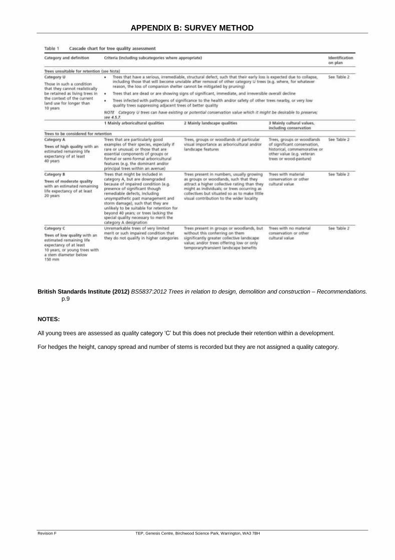
British Standards Institute (2012) BS5837:2012 Trees in relation to design, demolition and construction – Recommendations.
p.9 NOTES:
All young trees are assessed as quality category ‘C’ but this does not preclude their retention within a development. For hedges the height, canopy spread and number of stems is recorded but they are not assigned a quality category.
Waddow View Clitheroe Arboricultural Impact Assessment
6896.001 Drawings January 2019 Version 1.0
DRAWINGS
Drawing 1 - Tree Constraints Plan Drawing 2 - Tree Removal and Protection Plan
Drawing 3 - Recommended Tree Protection Fencing Drawing 4 - Above Ground Construction Specification
T1
T2
T3
T4
T5
T6
T7
T8
T9
T10
T11
T12
T13
T14
T15
T16
T17
T18
T19
T20
T21#
T22
T23
T24
T25
T26
T27
T28
T29
T30
T31
T32
T33
T34
T35
T36
T37
T38
T39
G7
G3
G1
G1
G2
G5
G4#
H1
H2
H8
H7
H6
H9
H5
H5
H5
H4
H3
G6
BS
5
83
7:
20
12
T
RE
E
CO
NS
TR
AI
NT
S
RE
PO
R
NOTE: This drawing should be read in conjunction with
the respective Arboricultural Survey Data (Appendix A).
T1 Individual trees
G1 Groups of trees
*
#
Survey Boundary
Approximate location
(Feature not shown on topo)
H1 Hedgerow
Root Protection Area (RPA)
Tree Preservation Order (TBC)
Category A
(High quality)
Category B
(Moderate quality)
Category C
(Low quality)
Category U
(Unsuitable for retention)
Tree Quality Categorisation
(Based on BS 5837:2012 Trees in relation to design, demolition
and construction - Recommendations)
KEY
[This drawing must be reproduced in colour]
Hedgerow
(Not categorised)
Drawing Number
D6896.101
Genesis Centre, Birchwood Science Park, Warrington WA3 7BH
Tel 01925 844004 e-mail [email protected] www.tep.uk.com
Description
Reproduced by permission of Ordnance Survey on behalf of Her Majesty's
Stationery Office.
© Crown Copyright and database right 2010. All rights reserved.
OS LICENCE NUMBER 100022432
Rev Drawn Approved Date
N
Title
Drawing 1 - Tree Constraints Plan
Project
Waddow View, Clitheroe
Arboricultural Impact Assessment
Drawn Scale
ML RMG 1:2000 @ A3
Checked
JGS
Approved Date
28/02/2018

W
W
W
W
B
L
S
G
1
S
6
W
W
W
W
W
W
W
W
W
W
W
W
W
W
W
W
W
W
WW
W
SSG1H8
SS
G1H
8
S
S
G
1
H
8
S
S
G
1
H
8
S
S
G
1
H
8
S
S
G
1
H
8
S
S
G
1
H
8
S
S
G
1
H
8
S
S
G
1
H
8
S
D
G
2
H
8
S
S
G
1
H
8
S
S
G
1
H
8
S
S
G
1
H
8
S
S
G
1
H
8
S
S
G
1
H
8
S
S
G
1
H
8
S
S
G
1
H
8
S
D
G
2
H
8
S
S
G
1
H
8
S
S
G
1
H
8
SS
G1H
8
SS
G1H
8
SS
G1
H8
S
D
G
2
H
8
W
W
W
W
W
W
W
W
W
W
W
W
W
W
W
W
W
W
W
W
W
W
W
W
W
W
W
W
W
W
W
W
W
W
W
W
W
W
W
W
W
W
W
W
W
W
Sta
Ground
Burial
El
Sub
Ordnance Survey, (c) Crown Copyright 2018. All rights reserved. Licence number 100022432
W
W
W
W
W
W
W
W
W
W
W
W
W
W
W
W
W
W
W
W
W
W
S
D
G
2
H
8
S1
S2
S3
S4
F1
F2
F3
F4
F5
7
4
.
4
4
0
2
2
5
m
m
C
L
A
Y
@
1
:
1
4
9
74.291
CL76.641
74.440
225mm CLAY @ 1:167
74.260
CL76.828
74.291
225m
m
C
LA
Y @
1:165
7
3
.
9
4
1
CL77.054
7
4
.
2
6
0
2
2
5
m
m
C
L
A
Y
@
1
:
1
6
7
7
3
.
6
3
3
CL78.830
7
3
.
9
4
1
2
2
5
m
m
C
L
A
Y
@
1
:
1
6
7
73.415
73.633
225m
m
C
LAY @
1:167
7
3
.
2
8
4
7
3
.
4
1
5
2
2
5
m
m
C
L
A
Y
@
1
:
1
6
7
7
4
.
5
5
1
1
5
0
m
m
C
L
A
Y
@
1
:
1
4
9
74.233
CL76.585
74.551
150mm CLAY @ 1:133
7
4
.
0
1
4
CL76.556
7
4
.
2
3
3
7
3
.
9
3
0
CL75.526
7
4
.
0
1
4
1
5
0
m
m
C
L
A
Y
@
1
:
1
3
2
7
3
.
7
2
0
CL75.297
7
3
.
9
3
0
1
5
0
m
m
C
L
A
Y
@
1
:
1
3
3
7
3
.
6
3
4
CL76.587
7
3
.
7
2
0
1
5
0
m
m
C
L
A
Y
@
1
:
1
3
2
7
4
.
5
5
4
S1.8HB
CL76.658
F1.7
CL76.650
7
4
.
6
4
9
900m
mØ
C
ulvert
9
0
0
m
m
Ø
C
u
l
v
e
r
t
C1
CL: 74.950m
IL: 73.050m
C2
CL: 74.950m
IL: 73.020m
S5
CL77.416
S6
CL75.022
S7Outfall
CL74.000
C3
CL: 73.725m
IL: 71.580m
C4
CL: 73.725m
IL: 71.426m
B
L
S
G
1
S
6
W
W
W
W
S
S
G
1
H
8
W
W
S
D
G
2
H
8
W
W
W
W
W
W
S
S
G
1
H
8
S
S
G
1
H
8
O
P
P
T
Y
P
E
5
2
A
S
T
Y
P
E
5
2
O
P
P
T
Y
P
E
5
5
W
W
S
S
G
1
H
8
W
W
W
SDG2H8
S
D
G
2
H
8
W
B
L
S
G
1
S
6
S
S
G
1
H
8
SDG2H8
BLS
G1S
6
W
W
W
W
BLSG1S6
W
W
W
W
W
W
W
W
W
W
A
S
B
E
D
A
L
E
A
S
B
E
D
A
L
E
A
S
B
E
D
A
L
E
O
P
P
B
E
D
A
L
E
A
S
B
E
D
A
L
E
O
P
P
B
E
D
A
L
E
A
S
B
E
D
A
L
E
A
S
B
U
C
H
A
N
A
N
A
S
B
U
C
H
A
N
A
N
A
S
B
U
C
H
A
N
A
N
W
W
W
W
W
W
W
137
135
133
145
143
141
140
138
139
142
144
146
159
160
156
154
152
151
149
148
147
150
153
155
158
193
192
200
199
201
202
203
204
205
195
194
19
26
24
23
109
110
111
112
113
114
115
104
103
102
101
100
99
98
131
132
134
136
25
27
22
18
17
20
1
2
3
4
6
9
11
13
14
15
12
10
8
105
5
117
116
106
108
130
129
126
122
127
121
120
119
118
161
162
163
174
172
171
168
167
165
166
164
169
170
173
175
16
198
197
7
21
107
157
176
177
178
206
28
97
95
76
75
74
73
72
71
70
69
68
59
58
57
56
55
54
53
52
51
50
49
48
47
46
45
44
43
32
31
30
29
83
82
81
84
80
79
77
88
85
86
87
89
90
92
93
94
91
78
60
61 62
63
64
65
66
67
96
196
W
W
W
W
B
L
S
G
1
S
6
B
L
S
G
1
S
6
W
W
W
W
W
W
W
S
D
G
2
H
8
W
W
SS
G1H
8
Sta
Ground
Burial
El
Sub
Ordnance Survey, (c) Crown Copyright 2018. All rights reserved. Licence number 100022432
Sta
Ground
Burial
El
Sub
Ordnance Survey, (c) Crown Copyright 2018. All rights reserved. Licence number 100022432
W
W
S
S
G
1
H
8
SDG2H8
W
W
W
179
180
181
182
183
184
185
186
187
188
189
190
191
207
208
Attenuation Basin
Attenuation Basin
B
I
N
S
42
41
40
39
38
37
36
35
O
P
P
T
Y
P
E
5
5
A
S
T
Y
P
E
5
5
34
33
W
W
W
S
S
G
1
H
8
128
SD
G
2H
8
124
123
125
SDG2H8
SU
B
ST
AT
IO
N
KIOSK
W
60
61
1
2
3
4
5
6
7
8
9
10
11
12
13
14
15
16
17
18
19
20
28
27
26
25 24
23
22
21
118
117
116
115
114
113
112
111
110
109
108
107
97
98
99
100
101
102
103
104
105
106
137
138
139
140
143
142
141
149
148
147
146
145
144
152
151
150
165
164
163
162
161
160
159
158
157
156
155
154
153
169
168
167
166
172
171
170
195
194
193
192
192
191
190
189
189
188
188
187
187
182
182
183
183
184
184
185
180
180
186
190
191
181
181
179
178
177
177
176
176175
174
174
173
173
196
208
207
206
205
204
203
199
198
197
200
200
201
201
202
202
76
75
75
74
74
73
73
72
72
71
71
70
70
69
69
68
68
67
66
66
65
65
64
64
63
63
62
62
59
59
58 57
56
56
55
55
54
53
52
51
50
49
48
47
46
46
45
44
43
42
42
41
41
40
40
39
39
35
35
36
36
37
37
38
38
34
33
32
31
30
29
29
90
89
88
88
85
85
86
86
87
87
83
82
81
81
80
80
79
79
78
78
77
84
91
91
92
93
94
95
96
T1
T2
T3
T4
T5
T6
T7
T8
T9
T10
T11
T12
T13
T14
T15
T16
T17
T18
T19
T20
T21#
T22
T23
T24
T25
T26
T27
T28
T29
T30
T31
T32
T33
T34
T35
T36
T37
T38
T39
G7
G3
G1
G1
G2
G5
G4#
H1
H2
H8
H7
H6
H9
H5
H5
H5
H4
H3
G6
5
.
7
m
3
5
.3
m
BS
5
83
7:2
01
2 A
RB
OR
IC
UL
TU
RA
L IM
PA
CT
A
SS
ES
SM
EN
T
NOTE: This drawing should be read in conjunction with
the respective Arboricultural Data Sheets (Appendix A).
T1 Individual trees
G1 Groups of trees
#
Survey Boundary
Approximate location
(Feature not shown on topo)
Category A
(High quality)
Category B
(Moderate quality)
Category C
(Low quality)
Category U
(Trees with existing or potential conservation value)
Trees to be retained
KEY
[This drawing must be reproduced in colour]
Category A
(High quality)
Category B
(Moderate quality)
Category C
(Low quality)
Category U
(Unsuitable for retention)
Trees to be removed
Hedgerow
(Not categorised)
H1 Hedgerow
(Not categorised)
Tree Protection Fencing (c. 1440m or 411 Heras panels)
(Must be installed prior to works commencement, see Drawing 3 for specification)
NOTE: Tree quality assessment based on BS 5837:2012 Trees in relation
to design, demolition and construction - Recommendations.
Special Mitigation Construction
(See Drawing 4 for indicative specification)
Drawing Number
D6896.102
Genesis Centre, Birchwood Science Park, Warrington WA3 7BH
Tel 01925 844004 e-mail [email protected] www.tep.uk.com
Description
Reproduced by permission of Ordnance Survey on behalf of Her Majesty's
Stationery Office.
© Crown Copyright and database right 2010. All rights reserved.
OS LICENCE NUMBER 100022432
Rev Drawn Approved Date
N
Title
Drawing 2 - Tree Removal and Protection Plan
Project
Waddow View, Clitheroe
Arboricultural Impact Assessment
Drawn Scale
RMG JGS 1:2000 @ A3
Checked
JGS
Approved Date
02/03/2018
Updated layoutAAAB
RMG
30.01.19
CONSTRUCTION EXCLUSION
ZONE (CEZ)
OPERATIONAL AREA
CONSTRUCTION EXCLUSION
ZONE (CEZ)
2m x 3.5m
Heras fencing
panel
Scaffold stabiliser struts every third panel (secured with
ground pins)
Vertical scaffold pole
driven 0.6m into the
ground between each
Heras panel
Drawing Number
D.TREE_FENCING.001
Genesis Centre, Birchwood Science Park, Warrington WA3 7BH
Tel 01925 844004 e-mail [email protected] www.tep.uk.com
DescriptionRev Drawn Approved Date
Title
Project
Drawn Scale
TDP RMG (not to scale) @ A3
Checked
JGS
Approved Date
16/06/2016
Per 3No. Heras panels (10.5m)
Component Quantity
2m x 3.5m Standard Heras panels 3
3m Galvenised steel scaffold pole 3
Heras fecurity fence clip 12
Heras stabilising support bar 1
Stabilising pin 2
Tree protection notice 2
Notes:
Drawing Number
Title
Tree Protection Fencing Specification
Project
No-dig edging: either
pin kerb cast in situ or
treated timber stake
and board
Notes
The cellular confinement system
and geotextile membrane should
be laid in accordance with the
manufacturers' specifications.
1
I
N
3
M
A
X
1
I
N
3
M
A
X
Existing
ground level
Surface course -
paving blocks (with
large spacer nibs) or
pervious tarmacGeotextile
fabric
2-6mm aggregate
bedding layer (no
fines) or binder course
All surfacing specifications to be
verified by an engineer prior to
installation
A levelling layer of sharp sand
may be laid beneath the system
to fill small undulations.
Cellular confinement
system e.g. cellweb
or equivalent.
infill material -
20-40mm clean
angular stone
Any variation to the materials
specified should be discussed
with the appointed arboricultural
consultant
Drawing Number
D.CCS.001
Genesis Centre, Birchwood Science Park, Warrington WA3 7BH
Tel 01925 844004 e-mail [email protected] www.tep.uk.com
Description
Reproduced by permission of Ordnance Survey on behalf of Her Majesty's
Stationery Office.
© Crown Copyright and database right 2010. All rights reserved.
INSERT CLIENTS OR MAP SOURCE OS LICENCE NUMBER IF USING
OS BASE MAPS
Rev Drawn Approved Date
N
Title
Project
Drawn Scale
RMG JGS Not to scale @ A3
Checked
JGS
Approved Date
10/08/2016
Drawing Number
Genesis Centre, Birchwood Science Park, Warrington WA3 7BH
Tel 01925 844004 e-mail [email protected] www.tep.uk.com
DescriptionRev Drawn Approved Date
N
Title
Cellular Confinement System Specification
Project
Drawn ScaleChecked Approved Date

HEAD OFFICE MARKET HARBOROUGH
GATESHEAD LONDON CORNWALL
Genesis Centre, Birchwood Science Park, Warrington WA3 7BH
No. 1 The Chambers, Bowden Business Village, Market Harborough, Leicestershire, LE16 7SA
Office 26, Gateshead International Business Centre, Mulgrave Terrace, Gateshead NE8 1AN
8 Trinity Street, London, SE1 1DB
4 Park Noweth, Churchtown, Cury, Helston Cornwall TR12 7BW
Tel: 01925 844004 Tel: 01858 383120 Tel: 0191 605 3340 Tel: 020 3096 6050 Tel: 01326 240081 E-mail: [email protected] E-mail: [email protected] E-mail: [email protected] E-mail: [email protected] E-mail: [email protected]