Embed Size (px)
Citation preview

M E M O R A N D U M
DATE: November 12, 2021
TO: The Natural and Cultural Assets Mapping Committee
FROM: Tammy Mayer Rosario, Assistant Director of Community Development
SUBJECT: Meeting #1 – Orientation and Review of Base Asset Network Map
Welcome! We are excited to have all of you on board as members of the Natural and Cultural Assets
Mapping Committee. As a reminder, our first meeting will be on Friday, November 12, 202 from 9-11
a.m. in the Building D Conference Room at the James City County Government Complex, 101-D Mounts
Bay Road.
As the attached agenda and presentation indicate, the focus of this meeting will be two-fold. First, we will
have an introductory element related to committee organization and orientation to the project. During this
portion of the meeting, the Committee may wish to consider and adopt the attached remote meeting policy
and resolution, which would allow remote participation in meetings by Committee members due to personal
matters or a disability or medical condition per Virginia Code Section 2.2-3708.2. This policy was based
upon one recently revised and adopted by the Planning Commission.
Second, we will roll our sleeves up and start getting into the work at hand by reviewing base maps and
discussing upcoming themed maps and next steps. We also will have two time periods set aside for public
input.
Staff is looking forward to working with all of you toward the successful development of a Natural and
Cultural Assets Plan for James City County. We believe this will be a rewarding process for all involved
and one which will have a long lasting impact on the quality of life in James City County.
Thank you in advance for your willingness to participate on the Mapping Committee and please call or
email me if you have any questions or concerns.
Attachments:
1. Agenda
2. Remote Participation Policy
3. Presentation

Agenda
Natural and Cultural Assets Mapping Committee James City County Government Center Building D Conference Room
November 12, 2021
9:00 a.m.
I. Call to Order
II. Organizational Items
III. Presentation and Overview of Natural and Cultural Asset Planning and Process
IV. Public Input -- limited to 3 minutes each and 15 minutes maximum
V. Review of the Base Asset Network Map
VI. Discussion on Values to Consider for Themed Maps
VII. Public Input – limited to 3 minutes each and 15 minutes maximum
VIII. Next Steps and Final Committee Comments
IX. Adjournment

NATURAL AND CULTURAL ASSETS MAPPING COMMITTEE OF JAMES CITY
COUNTY, VIRGINIA
POLICY FOR REMOTE PARTICIPATION
In accordance with § 2.2-3708.2 of the Code of Virginia, the following policy is established for
members’ remote participation in meetings of the Natural and Cultural Assets Mapping Committee
(the “Committee”) due to a personal matter or a disability or other medical condition. A member
may participate in a meeting through electronic communication means from a remote location only
as follows:
1. A quorum of the Committee must be physically assembled at one central location.
2. If a member’s remote participation is due to a personal matter:
a. On or before the day of a meeting, the member shall notify the Committee’s Secretary
(i.e. the Assistant Director of Community Development or a designee) that the
member is unable to attend the meeting due to a personal matter. The member must
identify with specificity the nature of the personal matter. The member should also
notify the Committee’s Secretary if the member desires to participate in a meeting
remotely due to personal matter that prevents the member’s physical attendance.
b. The Committee members physically present must approve the remote participation
by a majority vote, which shall be recorded in the Committee’s minutes. The decision
shall be based solely on the criteria in this policy, without regard to the identity of the
member or matters that will be considered or voted on during the meeting. If the
member’s remote participation is disapproved because such participation would
violate this policy, such disapproval shall be recorded in the Committee’s minutes
with specificity as to the conflict with this policy.
c. The Secretary shall record in the Committee’s minutes: (i) the specific nature of the
personal matter cited by the member, and (ii) the remote location from which the
member participated.
d. Remote participation by any member due to a personal matter shall be limited in each
calendar year to two meetings, or 25 percent of the meetings held per calendar year
rounded up to the next whole number, whichever is greater.
3. If a member’s remote participation is due to a disability or medical condition:
a. On or before the day of a meeting, the member shall notify the Committee’s Secretary
that the member is unable to attend the meeting due to (i) a temporary or permanent
disability or medical condition that prevents the member’s physical attendance, or (ii)
a family member’s medical condition that required the member to provide care for
such family member, thereby preventing the member’s physical attendance. The
member should also notify the Committee’s Secretary if the member desires to
participate in a meeting remotely but a disability or other medical condition prevents
the member’s physical attendance.
b. The Secretary shall record in the Committee’s minutes: (i) the fact that the member
participated through electronic communication means due to a disability or other
medical condition consistent with the categories in 3(a), and (ii) the remote location
from which the member participated.

4. The location of the member’s remote participation need not be open to the public.
5. For any remote participation by electronic communication means, the Secretary of the
Committee shall make arrangements for the voice of the member or members to be heard
by all persons in attendance at the meeting location.
_________________________________
Secretary
Adopted by the Natural and Cultural Assets Mapping Committee of James City County,
Virginia, this 12th day of November, 2021.

GREEN INFRASTRUCTURE CENTER
Overview: Natural and Cultural Assets Plan for
James City County
Orientation for Natural and Cultural Assets Mapping Committee
(NCAMC) By Karen Firehock and Matt Lee, Green Infrastructure Center Inc.
Friday November 12, 2021All graphic images and photos by GIC unless otherwise noted

Meeting AgendaI. Presentation: Project origin
Who is GIC
Why this plan now?
Schedule
Natural and Cultural Assets
How and what will we map?
II. Public Comments -- midpoint
III. Map Review
IV. Values Discussion
V. Public Comments – end point
IV. Next Steps and Final Committee Comments Great Blue Heron at York River State Park

The Green Infrastructure Center helpscommunities evaluate their natural and cultural assets to maximize ecological, economic and cultural returns. We do this by:
Building landscape modelsTeaching courses and workshops Research into new methodologies
Helping communities create strategieswww.gicinc.org

Some examples of GIC’s work in rural Virginia landscapes… (there are many more…)
Connecting and conserving intact landscapes to conserve biodiversity, clean water and cultural landscapes.
Albemarle County, VA Accomack County, VA Conserving natural landscapes in the face of rising seas and protecting the fisheries of the Chesapeake Bay.
New Kent County, VA Planning to conserve natural landscapes that support recreation, cultural and heritage values.
Suffolk, VA Protecting scenic, heritage and working landscapes in a growing coastal county with competing demands.
Grayson County, VA
Conserving working landscapes, rural character and wildness in a remote VA county.

This plan is an operational initiative in the 2035 Strategic Plan and an outgrowth ofaffirmed community priorities established during the recent update of the county’s comprehensive plan. Prioritizing the protection of natural lands and open spaces was the most highly ranked and supported objective across all three rounds of community engagement. This process will create a Natural and Cultural Assets Plan to meet this comprehensive plan action:
ENV Goal - Continue to improve the high level of environmental quality in James City County and protect rural and sensitive lands and waterways that support the resiliency of our natural systems for the benefit of current and future generations.
Strategy ENV 3 - Protect and conserve environmentally sensitive areas, and work to maintain or promote the ecosystem services provided by all natural areas.
Action ENV 3.1 - Maintain and promote biological and habitat diversity, ecosystem services, and habitat connectivity by protecting wildlife and riparian corridors between watersheds, sub-watersheds, catchments, and tidal and nontidal wetlands, and by developing and implementing a green infrastructure plan.
Impetus for the project:

The process…to create the Natural and Cultural Assets Plan
TAC = Technical Advisory Committee of County staff – advice, review, tech supportMC = Committee Appointed by the Board – community priorities, engaged with future implementation, testing ideasBOS = Board of Supervisors – review and critique, future adoption of the planSTAFF: JCC Staff contact for this project is [email protected]
Tasks 2021 – 2022 Jul Aug Sep Oct Nov Dec Jan Feb Mar Apr May Jun Jul
Task 1: Assessment, Work Plan and Team Orientation GICTask2: Establish Data Needs and Obtain or Create Relevant Information
GIC & JCC
GIC
Task 3: Identify Current Natural Assets = Base MapCreate a cultural Assets Overlay
GIC TAC MC
Task 4: Identify Threats to and Opportunities for Green Infrastructure Assets
TAC MCBOS
TAC MC
Task 5: Implementation Strategies and Plan from GI Modeling and Prioritization
TAC MC Public Mtg.
Wrap upBOS

Committee Member’s Roles: Evaluate maps and models of the best natural resources and culturally important landscapes in the County as well
as opportunities to improve areas (restoration or reconnections).
Assist with outreach ideas and ways to increase public engagement and interest in the project. Consult with your neighbors, colleagues and others to bring additional perspectives to the group. There will also be a community survey and a workshop to provide for participation by the general public.
Perspectives from the recently concluded Comprehensive Plan update such as ideas and goals already generated concerning parks, open spaces, conservation or community character will be utilized.
Committee Procedures: The committee is advisory only and is not a decision making body. We will seek consensus whenever possible in
making recommendations, but unanimous agreement is not required to forward ideas to the staff and board.
All perspectives will be captured during the meeting and all viewpoints will be respected.
Please listen for new understanding, and bring new ideas and data to the table. Data that cannot be verified, lacks a scientific or valid method, or which hasn’t been consistently collected may not be utilized.
Meeting summaries will be sent following each meeting to ensure that ideas and actions are captured and committee members can communicate with County staff at any time during the process.
We ask that you not speak to the press on behalf of this committee without conferring first with the rest of the committee and staff.
What are Natural Assets? Why do we need to evaluate them?
Planning to conserve natural landscapes helps support recreation, cultural and heritage values. It also protects drinking water and makes a community more resilient to changing climates. These natural resources are assets for our county!

Benefits of Conserving Natural Assets Preserving biodiversity and
wildlife habitat. Conserving working lands such
as farms and forests, that contribute to the economy.
Protecting and preserving water quality and supply.
Providing cost-effective stormwater management and hazard mitigation.
Improving public health, quality of life and recreation networks.

Natural Assets also support Cultural Assets!
Many of our heritage and recreational resources are defined by their natural settings. To protect these uses and their interpretation and enjoyment, we should also conserve the landscape.

What happens when we only think of structures without the landscape
This image is from VA…

Process – a base map, themed maps, risks then strategies

We need to protect habitat cores to conserve ‘interior habitats.’
Take the average tree height e.g. @ 100 feet and multiply by 3 to get edge. Subtract that to learn what remains and whether there is enough area to constitute a core. If smaller, it may still be a key “patch” or “site.”
Interior = Total Area – 3(h)
Certain species, such as the cerulean warbler, depend on and can only thrive in interior forests.

How we evaluate the quality of habitat cores = Core Metrics
Soil Productivity IndexTotal Area & Area of Interior Forest
Depth of Interior
Stream Conservation Units
Rare, Threatened, Endangered species
Length of Streams Within Interior Forest
Area of Wetlands
Topographic Diversity
Area of Surface Water/Aquatic Habitat
Landscape Diversity
Core
GICINC.ORG

Dividing a large core into two smaller cores = less interior habitat
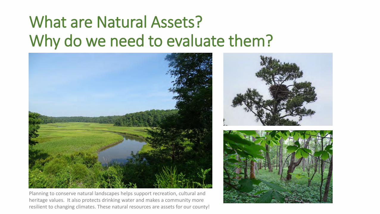
Bigger is better and shape matters too. The above images show edge area and interior. Notice which have the most interior.
Core Shape Matters
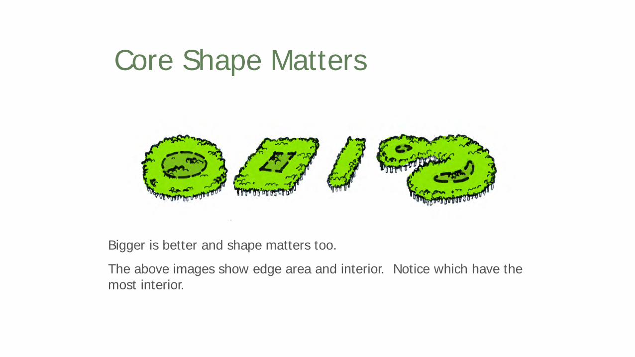
In nature, cores are not usually round. Fingers of green help animals move into and out of cores.
Core Shape Matters

A straight edge facilitates more parallel animal
movement, while a more curvilinear edge facilitates
movement into and out of the core.
Boundary Shape Also Matters

More Edge = More Impact Zones

Who causes trouble at the edges?
Brown Headed Cow Bird
Invasive plants/trees
Domestic (and wild) cats

The Type of Edge Matters TooThe hard edge (top) is not as conducive to supporting species’
diversity as the bottom soft (more gradual) edge.
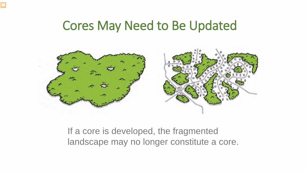
Cores May Need to Be Updated
If a core is developed, the fragmented landscape may no longer constitute a core.
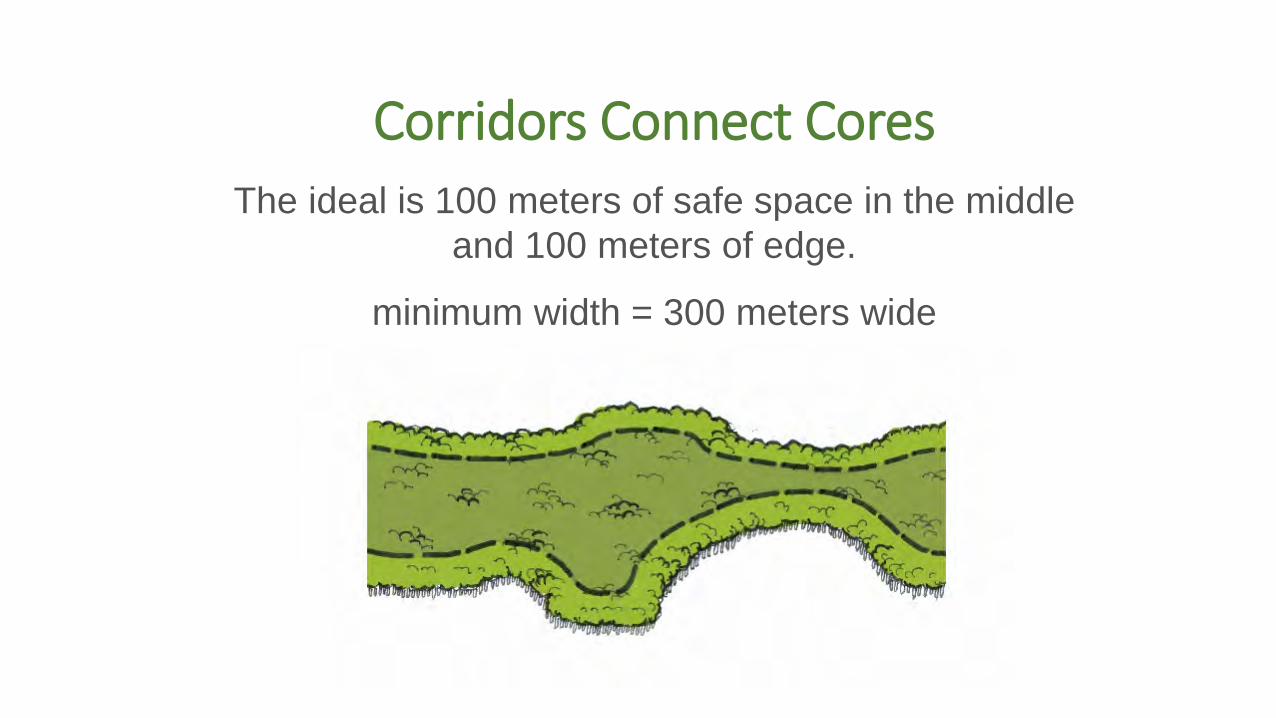
Corridors Connect Cores The ideal is 100 meters of safe space in the middle
and 100 meters of edge.
minimum width = 300 meters wide

Who can use the corridors? (300 meters is ideal…)
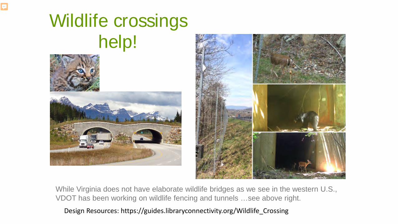
Design Resources: https://guides.libraryconnectivity.org/Wildlife_Crossing
Wildlife crossings help!
While Virginia does not have elaborate wildlife bridges as we see in the western U.S., VDOT has been working on wildlife fencing and tunnels …see above right.

When direct corridors are lost, some species can still hop across.

If cores or patches are too far apart, or if
a core is lost, species may become isolated and decline
over time.
Isolation = less resilience
However, sometimes when cores are lost, species may decline.

Creating a natural assets network planning requires thinking about how to connect the landscape.
It’s about connecting the landscape!
Not just key habitat patches but how we connect them!
The more connected the landscape, the more resilient it is!

We can keep land connected with development but only if we plan at a larger scale.The problem of conserving landscapes when we don’t look beyond parcels…

Intact Forests = possibility for sustainable timber or wildlife management
Small parcels fragment forest into many owners
Large parcels create contiguous forest blocks
We use local parcel data to determine current and future intactness. Timber Asset = Contiguous Large Forested Parcels (>25 acres). A wildlife asset = > 100 acres

Example from New Kent County VA: we show how natural assets support recreational and cultural assets

Zoning Tools and Comp Plans Park and open space planning I.d. lands for PDR programs New ordinance development Species protection Heritage tourism and viewsheds Ag and Forestal Districts Easements Transportation plans: roads/trails Land management
Planning Applications
Public
Private
Regulatory Voluntary

1) Set Your Goals: What does your community/organization value?
2) Review Data – What do we know or need to know, to map identified values?
3) Map Your Community’s Ecological and Cultural Assets – Based on the goals established in Step One and data from Step Two.
4) Risk Assessment – What assets are most at risk and what could be lost if no action is taken?
5) Rank Your Assets and Determine Opportunities – Based on those assets and risks you have identified, which ones should be restored or improved?
6) Implement Opportunities – Include natural asset maps in both daily and long-range planning (park planning, comp plans, zoning, tourism and economic development, seeking easements etc)
Six Steps for Natural Asset Planning

We have begun the mapping and are ready to share a base
map with you today!
We want to make sure it is accurate, add local priorities,
and begin to design the network with you. Will look at a map after this presentation.

Discussion and Map ReviewWhat’s most important to you for this plan’s outcome?(each member 3 minutes)
Maps: See where there are high value habitat cores – any surprises? Any corrections?
We’ll work on connecting corridors next to complete the network and we’ll work on themed overlay maps for working lands (agriculture and forestry), water, and recreation/culture.

GIC Inc.320 Valley St
Scottsville VA, 24590434-286-3119www.gicinc.org
Karen Firehock: [email protected]
Matt Lee: [email protected]
Stu Sheppard: [email protected]
Lauren Doran: [email protected]