Embed Size (px)
DESCRIPTION
Applying ISO/TC 211 Standards in the Development of Data Content Standards. Session 6210. Spatial Data and Professional Standards in Action The 100th AAG Annual Meeting Philadelphia, Pennsylvania March 2004 Presented by Julie Binder Maitra Federal Geographic Data Committee. - PowerPoint PPT Presentation
Citation preview
1
ISO/TC 211 Geographic information/Geomatics
Session 6210. Spatial Data and Professional Standards in ActionThe 100th AAG Annual Meeting
Philadelphia, PennsylvaniaMarch 2004
Presented by Julie Binder Maitra
Federal Geographic Data Committee
Applying ISO/TC 211 Standards in the Development of Data Content Standards
2
ISO/TC 211
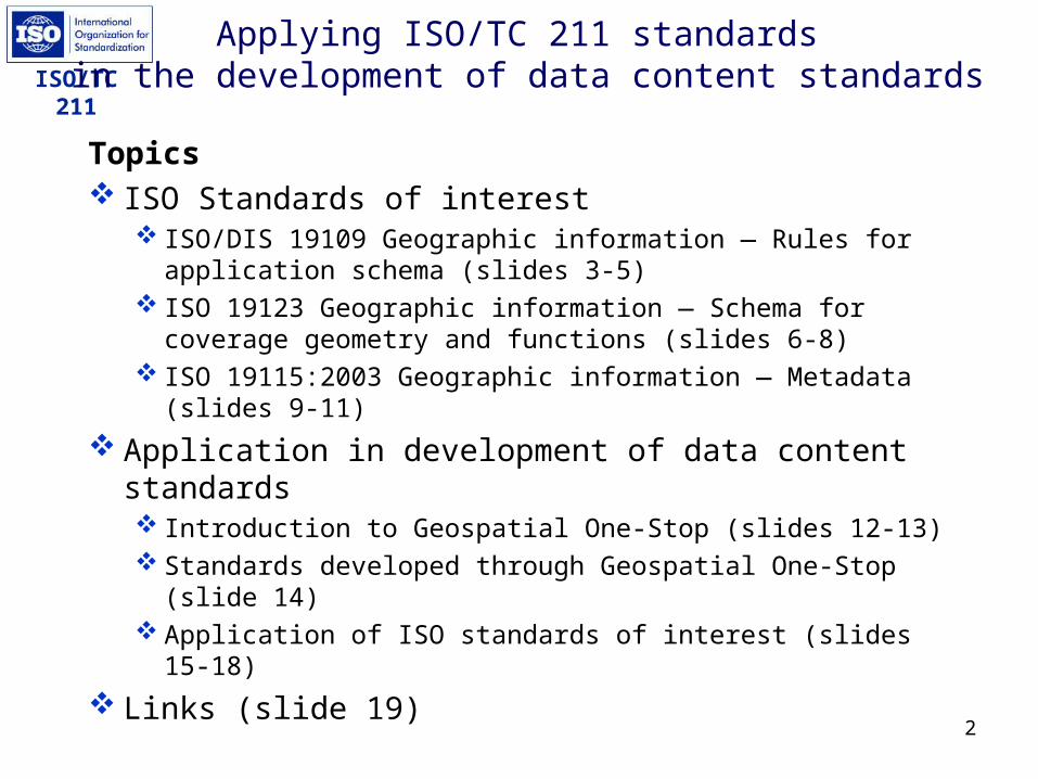
Applying ISO/TC 211 standards in the development of data content standards
Topics ISO Standards of interest
ISO/DIS 19109 Geographic information — Rules for application schema (slides 3-5)
ISO 19123 Geographic information — Schema for coverage geometry and functions (slides 6-8)
ISO 19115:2003 Geographic information — Metadata (slides 9-11)
Application in development of data content standards Introduction to Geospatial One-Stop (slides 12-13) Standards developed through Geospatial One-Stop (slide
14) Application of ISO standards of interest (slides 15-18)
Links (slide 19)

3
ISO/TC 211ISO/DIS 19109 Geographic information —
Rules for application schema
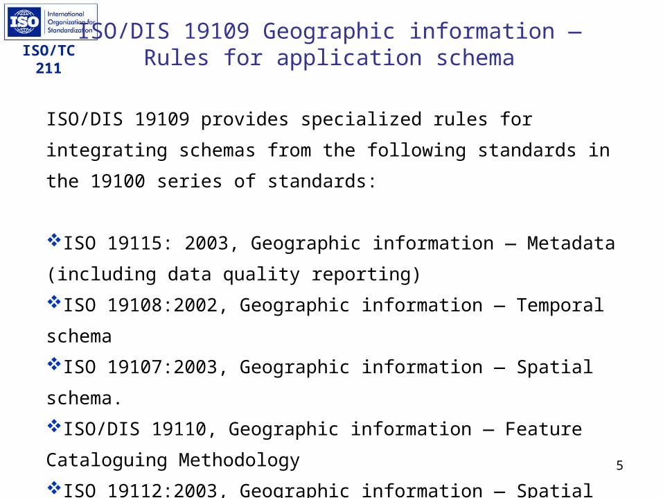
Presents General Feature Model for defining geographic features
Provides rules for defining an application schema in Unified Modeling Language (UML)
Provides rules for integrating schemas from other ISO/TC 211 standards into an application schema for a complete data structure
Pending registration as Final Draft International Standard (FDIS); targeted for publication as an International Standard (IS) in May 2004.

4
ISO/TC 211ISO/DIS 19109 Geographic information —
Rules for application schema
Extract of General Feature Model
5
ISO/TC 211ISO/DIS 19109 Geographic information —
Rules for application schema
ISO/DIS 19109 provides specialized rules for integrating schemas from
the following standards in the 19100 series of standards:
ISO 19115: 2003, Geographic information — Metadata (including
data quality reporting)ISO 19108:2002, Geographic information — Temporal schemaISO 19107:2003, Geographic information — Spatial schema. ISO/DIS 19110, Geographic information — Feature Cataloguing
MethodologyISO 19112:2003, Geographic information — Spatial referencing by
geographic identifiers

6
ISO/TC 211
The online glossary for the U.S. Fish and Wildlife Service’s Interactive Map and Data Server (IMADS) provides these definitions for coverage:
• A digital version of a map forming the basic unit of vector data storage in ArcInfo. A coverage stores geographic features as primary features (such as arcs, nodes, polygons, and label points) and secondary features (such as tics, map extent, links, and annotation). Associated feature attribute tables describe and store attributes of the geographic features.
• A set of thematically associated data considered as a unit. A coverage usually represents a single theme such as soils, streams, roads, or land use.(from http://www.fws.gov/data/IMADS/glossary.htm ) Coverage can also be taken to mean the extent of the earth's surface covered by a data resource such as a national map series or remote sensing data.
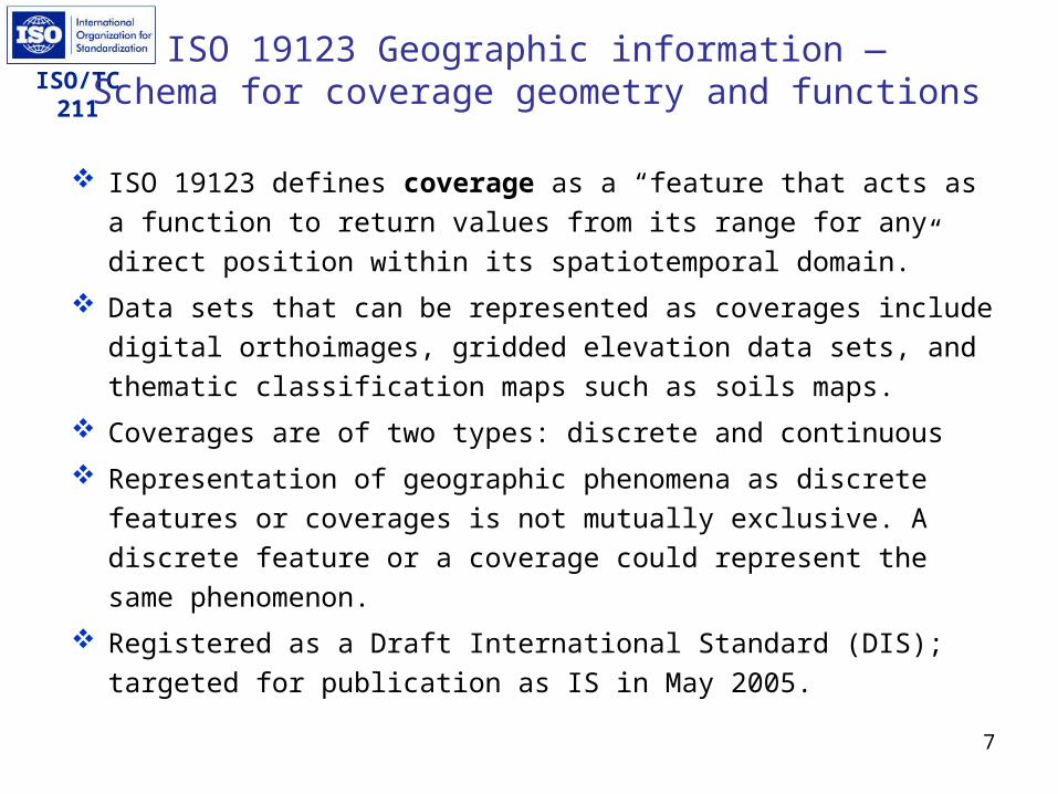
ISO 19123 Geographic information — Schema for coverage geometry and functions
7
ISO/TC 211
ISO 19123 defines coverage as a “feature that acts as a function to return values from its range for any direct position within its spatiotemporal domain.”
Data sets that can be represented as coverages include digital orthoimages, gridded elevation data sets, and thematic classification maps such as soils maps.
Coverages are of two types: discrete and continuous Representation of geographic phenomena as discrete features or
coverages is not mutually exclusive. A discrete feature or a coverage could represent the same phenomenon.
Registered as a Draft International Standard (DIS); targeted for publication as IS in May 2005.
ISO 19123 Geographic information — Schema for coverage geometry and functions
8
ISO/TC 211
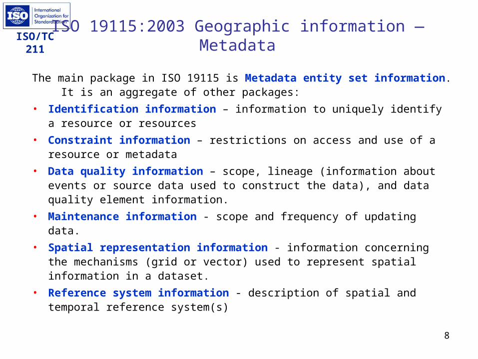
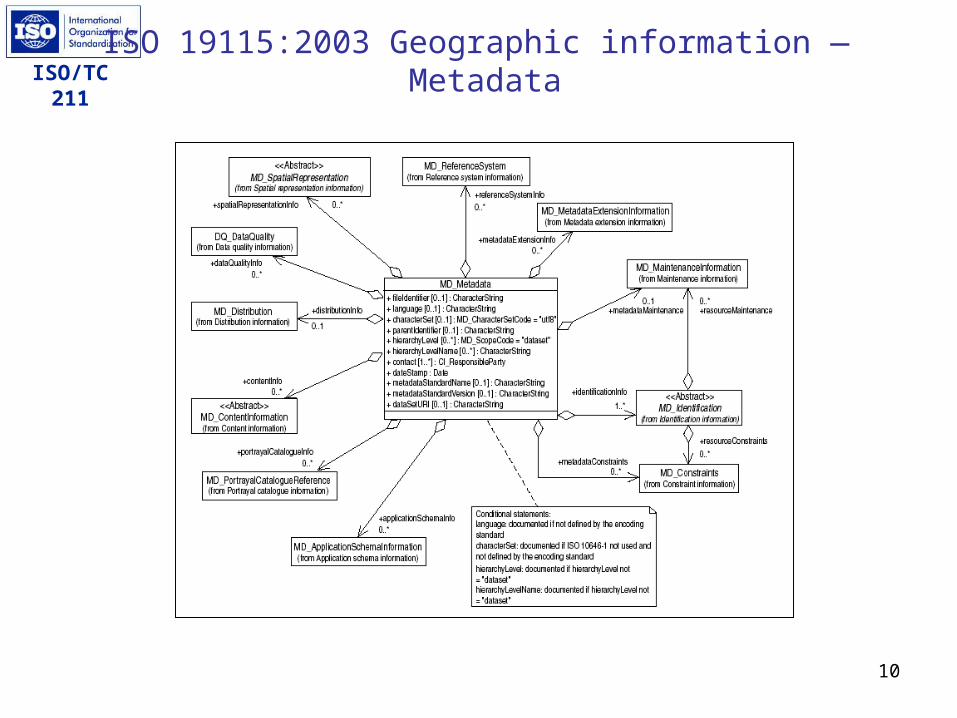
The main package in ISO 19115 is Metadata entity set information. It is an aggregate of other packages:
• Identification information – information to uniquely identify a resource or resources
• Constraint information – restrictions on access and use of a resource or metadata
• Data quality information – scope, lineage (information about events or source data used to construct the data), and data quality element information.
• Maintenance information - scope and frequency of updating data.• Spatial representation information - information concerning the
mechanisms (grid or vector) used to represent spatial information in a dataset.
• Reference system information - description of spatial and temporal reference system(s)
ISO 19115:2003 Geographic information — Metadata
9
ISO/TC 211
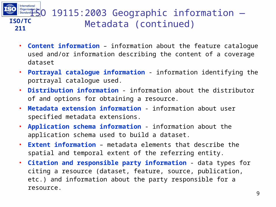
• Content information – information about the feature catalogue used and/or information describing the content of a coverage dataset
• Portrayal catalogue information - information identifying the portrayal catalogue used.
• Distribution information - information about the distributor of and options for obtaining a resource.
• Metadata extension information - information about user specified metadata extensions.
• Application schema information - information about the application schema used to build a dataset.
• Extent information – metadata elements that describe the spatial and temporal extent of the referring entity.
• Citation and responsible party information - data types for citing a resource (dataset, feature, source, publication, etc.) and information about the party responsible for a resource.
ISO 19115:2003 Geographic information — Metadata (continued)
10
ISO/TC 211ISO 19115:2003 Geographic information —
Metadata

11
ISO/TC 211Introduction to
Geospatial One-Stop E-Government (E-gov) Initiative
Component of President’s Management Agenda Geospatial One-Stop is one of 24 E-gov initiatives
ObjectivesRaise the visibility of the strategic value of geographic
information and the National Spatial Data Infrastructure (NSDI)
Accelerate implementation of the NSDIIncrease Federal agency accountability for the
stewardship and sharing of geospatial resourcesMake access to geospatial information faster, easier
and less expensive for all levels of government and the general public
12
ISO/TC 211
1. Develop standards for data themes used by many different GIS applications. These themes are known as NSDI Framework themes.
2. Inventory existing Framework data holdings and create metadata to enable data discovery through the NSDI Clearinghouse.
3. Create metadata for planned data acquisition and update of Framework data and serve metadata through the NSDI Clearinghouse to enable opportunities for partnerships.
4. Prototype and deploy enhanced data access and web mapping services for Federal Framework data.
5. Establish a (One-Stop) Federal Portal providing web services to extend the capabilities of the NSDI Clearinghouse Network.
Introduction to Geospatial One-Stop

13
ISO/TC 211 Standards under Development
through Geospatial One-Stop
Base Standard
TransportationElevation
Cadastral
HydrographyGovernmental
UnitsOrthoimagery
Geodetic Control
Air
Rail
Roads
Waterways
Transit
14
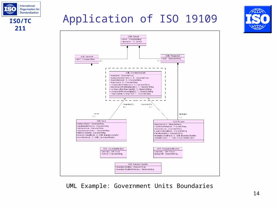
ISO/TC 211 Application of ISO 19109
UML Example: Government Units Boundaries
15
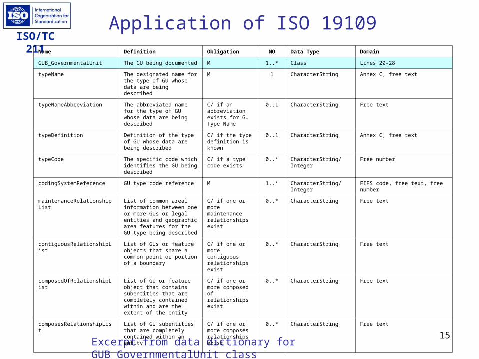
ISO/TC 211Application of ISO 19109
Excerpt from data dictionary for GUB_GovernmentalUnit class
Name Definition Obligation MO Data Type Domain
GUB_GovernmentalUnit The GU being documented M 1..* Class Lines 20-28
typeName The designated name for the type of GU whose data are being described
M 1 CharacterString Annex C, free text
typeNameAbbreviation The abbreviated name for the type of GU whose data are being described
C/ if an abbreviation exists for GU Type Name
0..1 CharacterString Free text
typeDefinition Definition of the type of GU whose data are being described
C/ if the type definition is known
0..1 CharacterString Annex C, free text
typeCode The specific code which identifies the GU being described
C/ if a type code exists
0..* CharacterString/ Integer Free number
codingSystemReference GU type code reference M 1..* CharacterString/ Integer FIPS code, free text, free number
maintenanceRelationshipList List of common areal information between one or more GUs or legal entities and geographic area features for the GU type being described
C/ if one or more maintenance relationships exist
0..* CharacterString Free text
contiguousRelationshipList List of GUs or feature objects that share a common point or portion of a boundary
C/ if one or more contiguous relationships exist
0..* CharacterString Free text
composedOfRelationshipList List of GU or feature object that contains subentities that are completely contained within and are the extent of the entity
C/ if one or more composed of relationships exist
0..* CharacterString Free text
composesRelationshipList List of GU subentities that are completely contained within an entity
C/ if one or more composes relationships exist
0..* CharacterString Free text
16
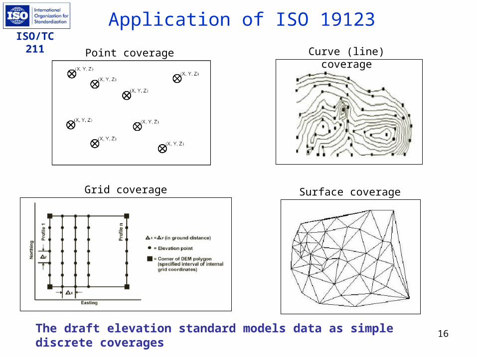
ISO/TC 211Application of ISO 19123
The draft elevation standard models data as simple discrete coverages
Point coverage Curve (line) coverage
Grid coverage Surface coverage

17
ISO/TC 211 Application of ISO 19115
Standards developed through Geospatial One-Stop will be compliant with ISO 19115
Some elements listed as optional in ISO 19115 are mandatory for Geospatial One-Stop
examples: Metadata standard name, Metadata standard version, Dataset purpose, Dataset progress, Dataset maintenance and update frequency
ISO 19115 elements closely match elements in FGDC Content Standard for Digital Geospatial Metadata, FGDC-STD-001-1998 (version 2.0); therefore, data standards will be compliant with FGDC standard
FGDC standard lacks metadata elements for language and character set
18
ISO/TC 211 Links
ISO Technical Committee 211, Geographic information/Geomatics, www.isotc211.org
Geospatial One-Stop, www.geo-one-stop.gov FGDC Content Standard for Digital Geospatial
Metadata, FGDC-STD-001-1998 (version 2.0), http://www.fgdc.gov/metadata/contstan.html

19
ISO/TC 211 Thank you !
(Ms.) Julie Binder MaitraFederal Geographic Data Committee (FGDC)
590 National Center12201 Sunrise Valley Drive
Reston, Virginia 20192USA
Email: [email protected]: +1 703 648 4627
Fax: +1 703 648 5755