Embed Size (px)
Citation preview

Applied ModernismMilitary and Civilian Uses of the AerialPhotomosaic
Paul K. Saint-Amour
Abstract
This article is about a period of technology transfer – the late 1910s and
1920s – when wartime aerial reconnaissance techniques and operations
were being adapted to a range of civilian uses, including urban planning,
land use analysis, traffic control, tax equalization, and even archaeology. At
the center of the discussion is the ‘photomosaic’ : a patchwork of overlapping
aerial photographs that have been rectified and fit together so as to form a
continuous survey of a territory. Initially developed during the First World
War to provide coverage of fronts, photomosaic mapping was widely prac-
ticed and celebrated during the postwar years as an aid to urban develop-
ment. The article traces both the refinements in photomosaic technology
after the Armistice and the rhetorical means by which the form’s avant-
garde wartime reputation was domesticated into an ‘applied realism’ that
often effaced its site-specific perspective, its elaborately rectified optics, and
the oppositionality of both its military and civilian uses. The article has a
broader theoretical aim as well. Classic statements of both structuralist and
post-structuralist spatial theory (Barthes and de Certeau are the primary
examples here) have produced an ossified geometry wherein the vertical is
the axis of paradigm, top-down strategy, and manipulative distance and the
horizontal the axis of syntagm, grassroots tactics, and resistant proximities
and differences. In its close study of the technology and rhetoric surrounding
interwar photogrammetry, the article provides an example of how one might
reverse the long-standing misrecognition of high-altitude optics as effacing
time, difference, and materiality – and what it might mean to view such
optics as, instead, a resource in turning from abstract toward differential
conceptions of both aerial photography and our theoretical habits. This
turn I call ‘applied modernism’ , a term that accesses both the wartime
j Theory, Culture & Society 2011 (SAGE, Los Angeles, London, NewDelhi, and Singapore),Vol. 28(7-8): 241^269DOI: 10.1177/0263276411423938

photomosaic’s affiliation with avant-garde painting and its insistence that
portraits of the total are always projections from partial, specific vantages.
Key words
1920s j peace j representation j scopic regimes j surveillance j urbanism
j world war
So much information that would otherwise have been concealed from theenemy was revealed by the all-seeing lens. . . .No matter how carefullymachine-gun emplacements may have been concealed, their position wasoften betrayed by the disclosure of foot tracks made over-night to and frommunition dumps. Dummy trenches and other appurtenances of warfare weredetected easily enough, for the absence of shadow on the completed prints wassufficient to rouse and to justify suspicion. . . . [the enemy’s] possible futureactivities (as well as past and present) [were] laid before [the Allies] like anopen book. (Winchester and Wills, 1928, on First World War aerialreconnaissance)
Mrs. Smith’s washing can be seen hanging on the line, so you know Mrs.Smith’swashdayeven if youdon’tknowMrs. Smith. (Fairchild,1922, onpeace-time photogrammetry)
INHIS memoir, Overview: A Lifelong Adventure in Aerial Photography(1969), retired Brigadier General George W. Goddard casts his mindback 40 years to recall a good-natured dispute with then Major General
Douglas MacArthur about representation. It’s 1928; Goddard is a FirstLieutenant commanding the Air Corps’ 6th Photo Section, 4th CompositeGroup in the Philippines. Having dropped by on an impromptu inspection,MacArthur is being shown an aerial photomosaic, which Goddard describesas a map of the Bataan Peninsula.The General, outfitted as usual ^ ‘cream-colored britches, Sam Browne belt, high boots and spurs, and carrying ariding crop’ ^ peers skeptically at the array of overlapping aerial photos fittedpainstakingly together into a composite image. ‘Young man’, he declares,‘that is not a map, only the Corps of Engineers makes maps.’ ‘According toWebster’s Dictionary, sir’, Goddard brightly retorts, ‘a map is a representationof the surface of the earth, and here is one without any human errors.’MacArthur chuckles, but later, on his way out, he takes care to have the lastword: ‘You understand, young man, that’s not a map . . .yet!’ (1969: 201^2).Their exchange limns the problem-space of this article. A conversation inwhich targeting and cartography are deeply entangled turns on the question ofwhether representation is degraded or produced by human error. For Goddard,a pioneer of aerial reconnaissance and photogrammetry since the late 1910s,the aerial photo’s mechanical origins, indexicality, and detail-saturation freeit from such error, making it all the more a ‘representation of the surfaceof the earth’ ^ all the more quintessentially a map.1 But where for Goddarderror mars mimesis, for MacArthur the unerring aspect of the aerial
242 Theory, Culture & Society 28(7-8)

photograph disqualifies it as a map, a medium whose essence and utilitydepend on its errors: its subtractive logic, its wandering away from saturationtoward selectivity and interpretation, even its encoding of mistakes that sig-nify.The aerialphoto, byMacArthur’s lights, is too full of information tobe leg-ible or navigable; it too nakedly presents without representing.
Even in declaring the photomosaic a non-map, the MacArthur ofGoddard’s recollection accepts at least one of the younger man’s premisesabout aerial photography: that it miniaturizes the territory without loss of res-olution or proportion, capturing without error. Similar claims had been madeabout aerial photographic reconnaissance since the FirstWorldWar, when thetechnique’s first advocates touted its precision in revealing enemy trench loca-tions and troop movements, its power to see through the ruses of camouflageand guide artillery targeting, and its production of peerlessly accurate histori-cal documents. Yet even those early partisans of the ‘all-seeing lens’ and itscapacity to open the book of enemy tactics recognized that the accuracy ofaerial photographs was a latent property that could be activated only when themedium’s native disfigurements were undone. Here areWinchester andWillsagain, tempering their claims about the raw legibility of vertical images:
The untrained mind can divine more information from a vertical photographthan the trained mind can from an ordinary topographic map, although wecannot claim for the aerial view extreme accuracy until it has been correctedfor distortion caused by tilt, and adjusted to a system of controls supplied by aground surveyor. It is possible that the timemay come when for cadastral andordnance purposes the aerial photographic survey will be accepted as a mapafter the customary references already provided by drawn maps have beenadded. (Winchester andWills, 1928:13)
Accuracyhere is a function of correction, not an innate property that precludescorrection. What Goddard referred to as ‘representation’ could emerge onlythrough the careful rectification of misrepresentation ^ and through supple-mentation by the very cadastral medium that aerial photographs were sup-posed to supersede. Even asWinchester andWills imagine a day when drawnmaps will give way to aerial photographs, they recognize that the latter, for alltheir density of information, will still require the ‘customary references’of thedrawn map in order to orient their users. A strange paradise, the aerial photo-graph: a medium whose accuracy emerged only through correction, and eventhen could only fully be appreciated by skilled interpreters; a medium inwhich the only way to prevent being overwhelmed by a superfluity of informa-tion was to add still more.
These finicky parameters were further narrowed in the case of imagescomposed of many individual stills, each of which had to be rectifiedand then harmonized with its neighbors. The resulting photomosaics (seeFigure 1) were not somuch taken as produced, often by workers trained in thehighly technical business of compensating for tilt, blur, vibration, and papershrinkage and expansion, as well as in minimizing the scalar and temporal
Saint-Amour ^ Applied Modernism 243

Figure 1 Photomosaic made in 1920 of land along the AnacostiaRiver east of Washington, DC. To illustrate the method of photo-mosaic composition, the edges of the composite image have beenleft untrimmed and the variation in the constituent images’ expo-sure uncorrected.Source: Lee (1922: 22a)
244 Theory, Culture & Society 28(7-8)

incompatibilities of their constituent images.To observe this is not to impugnthe accuracy of these images, exactly. But it is to find in them aparticular, con-tingent, perhaps deceptive, kindof accuracy, one that invited the viewer tomis-recognize as an integrated, synchronic image what was in fact a diachronicseries of images patchworked and blended together; to accept as unerring animage whose erroneous components had been squared, as nearly as possible,through compensatory fixes.Whether or not the photomosaic was a map, itwas anything but free from human error. It was, rather, a delicate pas de deuxof error and counter-error.
This article is about a period of technology transfer whenwartime recon-naissance techniques and operations were being adapted to a range of civilianuses, including urbanplanning, landuse analysis, traffic control, tax equaliza-tion, and even archaeology.2 Entailed in this transfer are a series of questionsabout what happens when technologies developed by a state for use against awartime adversary are adapted for peacetime use by that same state in relationto its own citizens, territory, and municipal infrastructures. In what ways doessuch a technology residually construct its domestic objects as distanced, derea-lized, and oppositional ^ that is, as targets in the military sense? What do thecivilian uses of the term target retain of their military origin? What complexi-tiesmight we lose by reducing our origin-narratives about particular technolo-gies to strictly military or civilian geneses? In respect to aerial imaging, ourthinking about such questions in recent decades has tended to proceed fromcertain articles of faith.The plan view, we like to say, totalizes by sheering offsingularity, complexity, anomaly, and dissent in favor of schematic simplicity.Relatedly, distance ^ especially the growing spatial, optical, and technologicaldistance between perceiver and seen ^ instrumentalizes and in some casesdehumanizes the seen in profoundly consequential ways. Finally, the growthof this distance has happened alongside an acceleration in perception, trans-mission, and feedback, to the point where what military planners now call the‘kill-chain’ ^ the time elapsed between identifying a target and destroying it ^is being massively compressed. This article attempts to identify some of theseams between these articles of faith as well as instabilities within each ofthem.Without denying that aerial imaging can both totalize and instrumenta-lize what it sees, it suggests that these operations have recoverable limits and,furthermore, that they sometimes require the very exceptions ^ the partial,the belated, the disjunctive, the differential, the site-specific, the erroneous ^whose absence appears to be their defining characteristic. As a paragon of per-fect visibility, I will suggest, aerial imaging depends on certain derangementsof vision that it hides in plain view.
I havemade a related argument about the use of the stereoscope in aerialreconnaissance interpretation from the First World War on (Saint-Amour,2003). By pairing vertical images taken hundreds or even thousands of feetapart, this technique vastly expands the virtual interocular base of the viewer,producing exaggerated 3-D effects that are interpretively useful in proportionas they expose the spatial contingency of human depth perception.This aerialhyperstereoscopy imparts a fantasy of all-powerful vision by insisting that we
Saint-Amour ^ Applied Modernism 245
always see from somewhere ^ or, more accurately, from two adjacent but dis-tinct somewheres. And because it asks the viewer to synchronically fuse twoimages taken in rapid diachronic sequence, the technique insists, albeit moresubtly, that seeing is an event rather than a condition; that we always see fromsome when. In turning here to consider the First World War’s other majorreconnaissance legacy ^ the aerial photomosaic ^ I will be discussing a formthat works harder to efface its multiplicities of viewpoint even as its diachroni-city becomes more difficult to conceal. For to look at a photomosaic is to bepulled in two directions: on the one hand, toward accepting the fiction that itsconstitutive images synch up in an integrated spatial geometry; and on theother, toward awareness of the fact that they were captured at discrete, oftendistant, moments.When the illusion of spatial integration fails, it does soprin-cipally because the composite image separates into tiles of nonsynchronoustime. In contrast to the vertiginous spatial depth-effects of hyperstereoscopy,the photomosaic offers the distinct vertigo of temporal parallax, one arisingfrom the experience of counterfeiting a spatially self-identical landscape froma constellation of segregatedmoments. A photomosaic is perforce a mosaic oftemporalities.
Myarticle has a broader theoretical aim aswell. In calling attention to theplanimetric view’s construction from a diachronic series of images andmoments, I underscore the extent to which our still-dominant notions aboutvertical imaging are themselves based on a misrecognition. These notionswere endorsed, as we have already seen, by thepractitioners of early aerial pho-tography. But they were given theoretical heft by structuralism’s fixation on abiaxial model of optical space, a model that post-structuralism attempted todismantle but more effectively perpetuated. According to this biaxialscheme, the vertical is the axis of order, paradigm, symbolic function, disutil-ity, unimpeded sightlines, and disembodied omniscience; whereas to thehorizontal belong disorder, syntagm, enunciative function, utility, partialsightlines, and exposure to visibility. In Roland Barthes’ ‘The Eiffel Tower’,for instance, the vertical stands outside of the city’s history and structure, yetby dint of that exemption gives spectators a privileged view of both: as thevantage most conducive to ‘intellection’, the Tower’s verticality ‘permits us totranscend sensation and to see things in their structure’, granting us access, ina single glance, to the city’s blueprint or x-ray and to something like its deeptime (1979: 9). Michel de Certeau’s ‘Walking in the City’ transposed Barthes’parable to NewYork, with the view from the top of theWorld Trade Centerepitomizing the ‘pleasure of ‘‘seeing the whole,’’of looking down on, totalizingthe most immoderate of human texts’. As against the labyrinth-dwellers atstreet-level, the Icarus on the 110th floor accedes to ‘a scopic and gnostic dri-ve . . . to this lust to be a viewpoint and nothing more’ (1984: 92). For deCerteau, the ground-dweller is notonly a sign exposed to the city planner’s pan-optic reading and schematizing; she may also elude that scopic disciplinethrough the practice of resistant pedestrian speech acts, walking and usingthe urban grid against the grain of its planners’ intentions.Yetdespite celebrat-ing the fla“ neur’s jamming of the planeur, de Certeau’s essay concretized
246 Theory, Culture & Society 28(7-8)

Barthes’ biaxial mapping: the vertical remains the viewpoint of power’smonopolyonparadigm, even if that power is occasionally stymied, and thehor-izontal remains the axis of the masses trapped in syntagm, even if they haverecourse to resistant enunciative tactics.
Of course, these influential essays are both more complex than myaccounts of them. Barthes descants on the ‘dialectical nature of all panoramicvision’, whose frictionless movement across an exposed landscape nonethelessrequires the viewer to struggle to decipher it by locating familiar ‘signswithinit’ from history, myth, and lived experience on the ground (1979: 10). DeCerteau makes the claim, althoughwithout dilating on it, that the haunting ofplaces by memory ‘inverts the schema of the Panopticon’ (1984: 108). But likeso many cognate discussions of power and visuality, both essays’ schematahave had more longevity than the exceptions, elaborations, and argumentativeeddies that complicate them, as the trellis outlives the bougainvillea it wasbuilt to support. One result, ironically, has been that essays interested indevel-oping a model of differential space have been annexed to the abstract space ofhighly schematic thinking. Here I use Henri Lefebvre’s terms deliberately, asa reminder that the native abstraction of ‘theory’makes it even more suscepti-ble than its objects to homogenization ^ to the dampening of internal differ-ences, the smoothing of anomalies, the honing off of resistant historicity. ForLefebvre, these differences within the space of both theory and social practiceare nothing less than the sites of potential social transformation:
From a less pessimistic standpoint, it can be shown that abstract space har-bours specific contradictions. Such spatial contradictions derive in part fromthe old contradictions thrown up by historical time. These have undergonemodifications, however: some are aggravated, others blunted. Amongstthem, too, completely fresh contradictions have come into being which areliable eventually to precipitate the downfall of abstract space.The reproductionof the social relations of productionwithin this space inevitably obeys two ten-dencies: the dissolution of old relations on the one hand and the generation ofnew relations on the other.Thus, despite ^ or rather because of ^ its negativity,abstract space carries within itself the seeds of a new kind of space. I shall callthat new space ‘differential space’, because, inasmuch as abstract space tendstowards homogeneity, towards the elimination of existing differences or pecu-liarities, a new space cannot be born (produced) unless it accentuates differ-ences. It will also restore unity to what abstract space breaks up ^ to thefunctions, elements and moments of social practice. It will put an end to thoselocalizations which shatter the integrity of the individual body, the socialbody, the corpus of human needs, and the corpus of knowledge. (1991: 52)
Aerial photography would seem to be the quintessence of abstract space, andindeed it has been cast repeatedly in that role for over a century. But this veryrole makes the recovery of aerial imaging’s differential qualities a matter ofconsequence both for visual culture studies in particular and for our criticalhabits of thought more generally. As much as this artcle reads a specific con-stellation of technologies, institutions, and rhetorics within a constrained
Saint-Amour ^ Applied Modernism 247

historical moment, it also offers a parable about our theoretical optics: aboutthe subsumption of theory’s differential energies by the homogenizing,abstracting processes of capital, and about the stakes of reversing thosehomogenizing processes. Here, to accomplish such a reversal would be tofind the differential not in opposition to the vertical (for that would be busi-ness as usual) butwithin the vertical, where its presence has long been camou-flaged, ignored, or misattributed exclusively to the ground. It would be tofind within the aerial photomosaic, and within the distance-optics of theory,some of the bird’s or god’s eye view’s most revealing and emphatic self-denunciations.
None of which should be read as an injunction to renounce high-altitude,comprehensive, integrative modes of seeing or thinking altogether. Note that,for Lefebvre, it is abstract space’s tendency to localize rather than totalize thatshatters individual, social, and epistemological bodies. Homogenization, thatis, can be a function of the local ^ both when it abstracts the local fromthe larger bodies on which it depends and when it extrapolates a false image ofthe whole from a part. To be immanently critical of the totalizing energieswithin a scopic regime or a system of thought is emphatically not the samething as giving up on the question of totalities, which is to say, on the questionof how ideological effects are produced through the effacement of connectionsbetween the distant and the proximate. Far from jettisoning total viewing infavorof partial, the kindof immanent critique I have inmind seeks a dynamic,interrogative relation between the two, recognizing that the total may be, inone instance, a special case of the partial or, in another, the category throughwhose occultation the partial produces the myth of its autonomy, normativity,or sovereignty.
In what follows, this immanent critique goes by the name of ‘appliedmodernism’. I use the expression for two reasons. First, as I describe here andelsewhere, early aerial photomosaics not only were associated with avant-garde painting during and after the First World War but also shared withmuch of that painting the premise that distortion was the only route to revela-tion. And, second, the photomosaic partook of a tendency shared by manyWestern modernisms ^ literary as well as visual ones ^ to view the total fromthevantageof the radically site-specific, subjective, or fragmentary, underscor-ing in the process how portraits of a given totality can be both generated andapprehended only from viewpoints that are optically and ideologically partial.Thus my earlier point that the total might be understood as a special case ofthe partial rather than the reverse.3 In calling the modernism of the photomo-saic ‘applied’, I wish to emphasize the utilitarian contexts of military andurban planning to which the photomosaic was conscripted from the 1910sonward. But I would stop short of implying that other modernisms were, bycontrast, ‘pure’or ‘non-instrumentalized’. In fact, it may be precisely by study-ing their parallel deployments inmilitary andciviliancontexts thatwe discoverthe full extent to which supposedly ‘pure’ modernisms were themselvesalways applied, always kitted out for oppositional spaces such as the battlefieldand themarketplace.
248 Theory, Culture & Society 28(7-8)

Because the photomosaic foregrounds questions of temporality, my dis-cussion of technology transfer, spatial and ethical distance, and velocity willbe focalized through the aperture of the event.This will mean askingquestionsabout what events are entrained in the production of photomosaics, from theflight and image-capturing by the cameraplane to the rectification andpiecingtogether of the mosaic to the mass-production of the composite image. In thewartime context, we will need to consider, too, the destructive events ^ theartillery salvoes, bombing runs, and infantry advances ^ that are variouslyplanned and confirmed by wayof the photomosaic. In such cases, the eventful-ness of the image’s production would seem to be eclipsed by the kill-chain itexists to set in motion ^ that is, by the sequence of events along which atarget is identified, its importance evaluated, a decision made, and destructiveforces unleashed.4 But what becomes of the status of the photogrammetricevent in peacetime, when the image is no longer motivated by the extremeeventfulness of the kill-chain? Does the civilian photomosaic map allow eachof its constitutive images to retain its native eventfulness, as both an imagetaken and a moment captured, without instrumentalizing it? Or, to thecontrary, is the eventfulness of the photograph effaced, first, by techniques ofrectification and, second, by the photo’s conscription to the logic of the map,whose utility requires the fiction of its uneventfulness? Is the eventfulness ofthe aerial photograph in peacetime the primary target at the end of the kill-chain it sets in motion?
Photomosaics at the Western FrontThe aerial photomosaic came intowidespreaduse as thephotographic correlateof trench warfare.With sites of engagement stretching for many lateral miles,and with those miles of front supported and supplied, in turn, by extensivebehind-the-lines networks, trench warfare made massive swathes of territorytactically relevant and therefore subject to reconnaissance overflights by thefledgling air services on both sides.The limitations of the aerial camera andits heavier-than-air platform, however, and the need to use telephoto lensesfrom an altitude above artillery range, meant that no individual image couldcapture very much ground at a resolution high enough to be useful to photo-graphic interpreters.5 In order to provide coverage of significant portions offront line and supporting positions, reconnaissance pilots flew in switchbacklanes, making exposures at regular intervals in such a way that each imagewould overlap about 20 percent with the adjacent images in its lane, and eachlane overlap, in its turn, with the lanes that bordered it (see Figure 2.) Toensure the verticality of the coverage, the plane had to fly as level as possible;to minimize blur, the pilot had to avoid lurches and vibrations. Once the filmhad been developed on the ground ^ often very rapidly, in cramped, lorry-mounted darkrooms ^ the prints were scaled to one another, fitted together toproduce a continuous image, and glued to a drawn map of the same scale.Themosaic itself was then photographed, and that image labeled, reproduced athigh speed and in massive numbers ^ again, by workers toiling in factory-like
Saint-Amour ^ Applied Modernism 249

conditions ^ and disseminated (see Sekula, 1975: 28). ‘The time and energysaved by this process is enormous’, writes Harold E. Porter in 1921, havingbeen a captain in the USArmyAir Service during the war.
Awhole county can be photographed in an hour or two, and a mosaic and mapmade of it in a few days; whereas to do the same work by an ordinary surveymight take a couple of months. Besides, there are no surveying gangs in thefront-line trenches. (1921:164)6
The interpreters of aerial reconnaissancewere not just the end-users of the dis-tributed mosaic images but also helped to produce them bydecoding the land-scape and leaving a record of their findings in the reproduced image’s key ormargin (see Figure 3). By pairing adjacent exposures from a given flight lineunder a stereoscope, they could produce parallactic depth-effects in the areasof overlap. They were trained to observe changes from one coverage to thenext, to spot camouflage and decoys by the shape or absence of the shadowsthey cast, and to decode subtle deformations of the landscape ^ to read, say, inthe bent blades of meadow-grass a sign that several men had passed through,
Figure 2 Diagram showing relations among altitude, exposureinterval, area covered, and mosaic overlap in a single lane of aerialsurvey coverage.Source: Ives (1920: 298)
250 Theory, Culture & Society 28(7-8)

and then to find the new gun emplacement at the end of the track. As Porterputs it, these military knowledge-workers were ‘trained to know how thingsought to look under all sorts of different conditions in a vertical photo’, andthereby to detect deviations from the expected norm. Against the uneventfulbaseline of the condition (‘how things ought to look’), they awaited signs of anevent ^ of some new initiative by the adversary that would require the equal-and-opposite event, the counter-event or event-in-kind, of targeting. From theinterpreter’s point of view, the target had less to dowith tactical value or mean-ing than with eventfulness: it was a break in the placid surface of ‘conditions’that irritated the kill-chain into an equally eventful restoration of placidity.This condition/event binarism tended to produce an indexical and starkly
Figure 3 Partial photomosaic of St Quentin, First World War. Notethe three supplementary images showing oblique views of featureson the vertical crescent; photo interpreter’s annotations; and theaccompanying map, upper left, oriented with the photomosaic. Theoriginal caption, lower right, reads: ‘No attempt has been made togive a complete interpretation of each photo. A few details such asM.G. [machine gun], T.M. [trench mortar] positions, Listening posts,probable Headquarters, etc., have, however, been shown on each setin order to assist in the location of further points of interest whichcan readily be distinguished by a careful study of the prints. Thesephotos should be examined in con junction with the larger series ofthe same sectors already issued. ’Source: Collection of the Imperial War Museum, London
Saint-Amour ^ Applied Modernism 251

decisionist heuristic according to which the eventful, event-provoking thingeither was or was not present. Allan Sekula’s account of this heuristic in mili-tary intelligence is worth quoting at length:
Simply put, theproblemwas todecidewhatwas there and to act on thatdecisionbefore ‘whatever it was’ moved. If the entity in question fell into the categoryof ‘enemy’, its destruction by artillery fire, or by other means, was ordered.The value of aerial photographs, as cues for military action, depended on theirability to testify to a present state of affairs. The photographic sense of‘having been there’, identified by Roland Barthes, must submit to thedemands of ‘being there.’ . . .The meaning of a photograph consisted ofwhatever it yielded to a rationalized act of ‘interpretation.’ As sources ofmilitary intelligence, these pictures carried an almost wholly denotativesignificance. . . .Within the context of intelligence operations, the only ‘ratio-nal’questions were those that addressed the photograph at an indexical level,such as ‘Is that a machine gun or a stump?’ In other words, interpreting thephotographdemanded that it be treated as an ensemble of ‘univalent’, or index-ical, signs ^ signs that could only carry one meaning, that could point to onlyone object. Efficiency demanded this illusory certainty. (1975: 27^8)
These were images without ambiguity, intrinsic interest, or a future beyondthe short-lived horizon of intelligence-gathering ^ imageswholly subordinatedto their denotative function and its date-stamped temporality. Once such animage had either been superseded by more recent coverage or assisted in theeradication of any unwelcome events it disclosed, its sole reason for being wasalso eradicated; it is as if the reconnaissance image were immolated alongsidethe target, indivisibly from the target, in the name of the ‘conditions’ it helpedrestore. (If suchwere the case, anyeventfulness inhering in the image’s produc-tion was indeed consumed by the eventfulness of what it denoted.)
For Sekula, this rationalist, instrumentalizing conception of the image is‘illusory’ because the same image may be resignified in another, peacetimecontext ^ imbued, for instance, with a rhetorical structure, a claimon thebeau-tiful, or the glamour of an authorship-relation. I suggest, however, that insteadof being celebrated during the war exclusively as the ‘triumph of applied real-ism’ (the phrase is Sekula’s), aerial reconnaissance was understood by FirstWorldWar practitioners not only as accurately denotative but also as cruciallydefamiliarizing, revealing objects only in proportion as it deformed both thegeometry and the temporality of human vision.We have already seen how theopen book of the enemy’s intentions became legible to photo interpreters onlyafter they had attempted to rectify the errors inherent in the image-taking.Interpreters who used hyperstereoscopy didn’t just correct for errors butactively exploited the delirious depth-effects inherent in their technique. Andif a revelation that comes of abandoning the spatio-temporal norms of visualitysounds remarkably like the pre-war avant-garde, at least a few souls in theRAF seem tohavemade a similar connection in labeling varieties of landscape‘‘‘CUBIST’’ country’ (Figure 4) and ‘‘‘FUTURIST’’ country’ in a 1918 atlasdesigned to familiarize new pilots with vertical views of the territory behind
252 Theory, Culture & Society 28(7-8)

German lines. Scholars referring to this text in thepast havedone so in order toconfirm something about the reception of avant-garde painting ^ that itsterms and visual modalities had become household words, or that itscontemporaries saw the Cubist and Futurist painters as having anticipatedthe estranging rectilinearity of the land seen from an airplane.7 However, faceto facewith the‘‘‘FUTURIST’’country’page (as against its‘CUBIST’counterpart),we can nowsee that it contains not a lone aerialphotograph but twooverlappingones ^ a rudimentary photomosaic, in other words ^ and that the compositephotographic image is accompanied by a swatch of cadastral map depictingthe same area (see Figure 5.) Whether ‘‘‘FUTURIST’’country’ resembles paint-ings by Boccioni, Balla, or Carra' any more than‘‘‘CUBIST’’country’does thoseof Picasso, Braque, or Gris ^ andwhether the difference between these disori-enting modes could be of any practical help in orienting young pilots ^ to calla de minimis photomosaic ‘Futurist’ in a photo atlas is to engage in a kind ofphotographic metacommentary. It reads, by the light of Futurism, not justthe denatured view of the earth from above but also the particular techniqueof thephotomosaic, with its projectionofdiscretemoments of seeingonto auni-fied picture-space, its dependence on a technologized circuit of production. Itapprehends, too, the high speeds that attend that circuit: velocities of airplane,shutter, photo development, interpretation, reproduction, dissemination,
Figure 4 ‘ ‘‘CUBIST’’ country’Source: RAF (1918)
Saint-Amour ^ Applied Modernism 253

decision, and assault; velocities, too, of innovation and industrialization in allof the foregoing. Such a reading may not deliver the photomosaic from itsinstrumentalplace in amilitarycommand arc. But itdoesdecouple that instru-mentality from a straightforwardly denotative optics, making indexicalitysomething that can be hallucinated precisely and exclusively from the site ofits liquidation. Far from being the triumph of applied realism, photogramme-try was understood by its wartime proponents as the triumph of appliedmodernism.
1920s Civilian Air SurveysI have argued that aerial photography’s departures from the conventions of aperfectly scaled orthographic map were a chief source of its use during theFirst WorldWar.When that technology was transferred to civilian practicesafter the war, however, the distortiveness that made it tactically useful in warappeared unseemly in peacetime, as if avant-garde optics could only be toler-ated in the nakedly oppositional context of battle.The result was a widespreadreapplication of the language of realism to aerial mapping. But this resurgenceof realism-claims was not just a way of making a wartime technology safe forcivilian use. It also registered the fact that the precision mapping demands ofcivilian photogrammetry required, if anything, more severe manipulationsand counter-distortions to make aerial photomosaics conform to the
Figure 5 ‘ ‘‘FUTURIST’’ country’Source: RAF (1918)
254 Theory, Culture & Society 28(7-8)

conventions of cadastral maps. Elaborated to the point of spawning a discreteprofession, these photographic and trigonometric rectification techniquesneeded a compensatory super-realism ^ a set of exaggerated claims about theaccuracy, transparency, and self-decryption of the medium ^ as a rhetoricalcounter-distortion. But while the disfigurations, discontinuities, and site-spe-cificities I have called ‘applied modernism’could be banished to both the opti-cal and rhetorical peripheries, they could not be eliminated. It will be ourtask in what follows, then, to read themodernism at themargins of peacetimephotogrammetry.
As Figures 3 and 5 illustrate, most wartime photomosaics were assem-bled at speed, with minimal attempts to hide the seams or the exposure,scale, and parallactic differentials between neighboring photos. But thesegaps and differentials could be significant.To begin with, themosaic’s constit-uent photographs were seldom perfectly vertical ^ that is, seldom taken withthe vertical axis of the camera’s lens exactly perpendicular to the groundor pro-jection plane ^ because camera-bearing aircraft were easily thrown out oflevel flight by turbulence. Fluctuations in the plane’s altitude caused changesin photographic scale from one exposure to the next. And even if the planeflew at a perfectly consistent altitude, scale remained a problem. In any photo-graph, there are as many scales as there are depth planes.This continuum ofscales is advantageous in most photographic contexts, as the greater scale offoreground objects contributes to the impression of their proximity over back-ground objects, giving the viewer non-parallactic depth cues. But in aerialphotos thatwould beused to rectifyexistingmaps, a consistent scalewas essen-tial. In vertical photos of topographically extreme terrain, the scale in whichvalleys appeared could differ noticeably from that of mountaintops; likewise,in an urban environment, with streets versus the tops of skyscrapers.Whilethe relief displacement ^ the radial ‘leaning’of objects away from the verticalphoto’s nadir ^ may have been essential to aerial stereoscopy, it played havocwith theplanimetric andorthographic conventions ofmostmaps, inwhichpro-jection lines are perpendicular to the projection plane rather than convergingtoward the perspective center. And the shadows of tall objects could produceareas of pseudoscopy ^ the reversal of relief effects ^ on a photomosaic if theywere oriented improperly. As Herbert E. Ives put it:
Even when ‘corrected’ and retouched, aerial photographic mosaics could pre-sent weird effects: in maps of cities, buildings sometimes look concave insteadof convex because the shadows are falling away from rather than toward theviewer, particularly if the map is conventionally oriented with North corre-sponding to the viewer’s‘up.’ (1920: 353)
An unrectified or ‘uncontrolled’ photomosaic, then, could look like an oldstreet with its cobblestones akimbo, the choppiness and radial warp of its con-stituent units drawing attention to the composite nature of the surface. Butwhen greater standards of photogrammetric accuracy were called for, as wasthe case with the civilian aerial survey projects from 1918 on, new procedures
Saint-Amour ^ Applied Modernism 255

arose for correcting (or, in the weirdly redundant term, orthorectifying) photo-mosaics. Fluctuations in the tilt and altitude of individual exposures were cal-culated and then counteracted with the use of more and more elaborateprojection printers.The same device could also alter the scale of a particulardepth plane, so that areas of the photo depicting an extreme depth or height(e.g. valleys or high plateaus) could be reprinted in a rectified scale and thenglued over the corresponding unrectified area. Relief displacement could beminimized by using only the central part of a given exposure rather than itsmore radially displaced perimeters. But even a scrupulously ‘controlled’mosaic was, at best, a geometric entente between the perspective projection ofits constituent photographs and the conventional planimetric projection towhich themosaic as a whole aspired.8
One method of controlling photomosaics was to plot the photos to anidentically scaled line-map of the terrain, whereby discrepancies betweenmosaic and mapwould guide rectification of the photos. Here we arrive at thephotomosaic’s mimetic mise-en-abi“ me: a medium supposedly capable ofcorrecting and even supplanting less accurate, less informative planimetricline-maps relied on those same maps to point up its optical waywardness. Iflone aerial photographs distorted the terrain, they at least did so in much thesame way the eye did, reproducing the relief displacement, the scale-differen-tial at varying altitudes, even the flatness of the unaided aerial view. In the con-trolled, orthorectified context of the photomosaic, hundreds or thousands offitted prints were made to represent not a humanly perceptible view of theterrain, but an imaginary viewexempted from the situatedoptical traits of par-allax and scale differentials. Finally, having been rectified, controlled photo-mosaics were retouched in order to conceal the composite mode of theirproduction. Tonal variations among adjacent prints were regularized by theapplication of a red dye to the negative; lines from shadows cast by the edgesof overlapping prints were painted out (Abrams, 1944: 228^9). By eliminatingits seams, themosaic’s makers gave it an artificial unity of perspective, unifor-mity of scale, and temporal simultaneity. A photographic form that revealedcamouflage had itself beencamouflaged, its contingencies disguisedor leveledso that it resembled an idealized schematic as seen by a disembodied observer.Canonized by intelligence personnel, surveyors, police, entrepreneurs, andcity planners as the utmost in photographic realism, the mosaic was, per-versely, considered ‘accurate’ only in proportion as it bent the rules of opticsaway from perception toward orthogony. Aerial photomosaics ended up recon-secrating as ideal the verycartographic abstractions they weremeant to corrector supersede.
After theArmistice, some of the reconnaissance workers trained duringthe war remained in national air corps, mapping colonies, mandates, and pro-tectorates (as in the British case) or arguing that photogrammetry researchand development should continue despite postwar military budget cuts anddisarmament (as in the US).9 Others applied their military training in civilianmapping projects, both privately and publicly funded. In France, according toGoddard, a law passed shortly after the signing of the Treaty of Versailles
256 Theory, Culture & Society 28(7-8)

required all cities above a certain size ^ several hundred in all ^ to be surveyedaerially by civilian companies.Territory laidwaste during the war was also sur-veyed by the FrenchArmyAerial Photographic Service, inmanycases becauseproperty lines had been effaced and local archives destroyed in the fighting(Goddard, 1969: 101 n 5).10 Whereas French aerial photographers were put towork in a reparative relation to the destructive work they had abetted duringthe war, US reconnaissance veterans were sometimes described as bringingthewar’s adversarial energies toAmerican cities. Nelson P. Lewis, a consultingcity planning engineer with the Russell Sage Foundation, extolled the virtuesof a repurposed photogrammetry that retained aspects of its wartime strategicuses:
We know that aerial surveys and mapping were of the greatest possible useduring theWorldWar in locating points within the enemies’ lines which werevulnerable to attack, but we have found that this samemethod of aerial photo-graphic surveying will disclose the logical points of attack for those who arebent, not upon destructive but upon important constructive work, uponthe better utilization of natural conditions for commerce, for homes or forwholesome recreation. (Lewis, 1922: 212)
During the 1920s, dozens of similar articles appeared in The American CityMagazine and other urban planning periodicals; many of them partook ofNelson’s difficulty in swerving from a logic of targeted attack to a claimof ‘con-structive work’, as if uncertain how to honor the returning soldiers and thewar technologies in which they had been trained while reassuring non-comba-tants that both could be absorbed safely into civilian life. A less ambivalentpoint of view lamented photogrammetry’s adoption by themilitary:
[the]mapping use of airplanephotographyhasbeen to a certain extent set backby the war, for the reason that certain scientific views [e.g. the chemical devel-opment of color-sensitive emulsions that could help reveal camouflagedobjects], which are not relevant to commercial photography rather held theforeground. (Brock and Holst, 1919: 705^7)11
Two incompatible portraits of aerial photogrammetry emerged: the trium-phant yet domesticable war technology versus the civil technology hamperedby military misappropriation. That there were, by 1920, warring camps inrespect to aerial photography’s originary conditions reveals the extent towhich that origin-narrative mattered ^ and the power of stigma and glamourthat a technology could carry once it had been marked by war.
The catalyst for this debate was the postwar emergence of companiessuch as Abrams Aerial Survey Corporation, Aero Service, Brock andWeymouth, and Fairchild Aerial Surveys, which began to make increasinglydetailed photomosaic maps of US cities. Fairchild’s 1921 (see Figure 6) and1924 maps of NewYork, in particular, were widely discussed and publicizedin newspapers, aviation weeklies, scientific monthlies, and city planning
Saint-Amour ^ Applied Modernism 257

Figure 6 Detail, photomosaic of Manhattan by Fairchild AerialCamera Corporation, taken 4 August 1921. The caption reads: ‘ThisMosaic was made by assembling 100 Aerial Photographs taken whileflying over the area at an altitude of 10,000 feet. ’Source: Fairchild Aerial Camera Corporation (1921)
258 Theory, Culture & Society 28(7-8)
journals, eliciting rapturous celebrations of the new form’s beauty, accuracy,and myriad uses; the latter were said to include recording city growth, inform-ing current zoning and future planning, correcting errors in extant line maps,revealing traffic problems and untaxed buildings, even allowing policeinspectors to ‘note the location and details of every roof exit, scuttle hole andskylight’12 (see Fairchild, 1924b: 16^17; Unsigned, 1922a: 253^5, 1922b:113^19, 1922c: 46, 1924: 37:3). Some revealing moments of ekphrastic rapturecame from the photographers themselves, who wrote puff pieces for their ownprojects. Here is ShermanM.Fairchild, whowould become themost celebratedcivilian figure in interwar aerial surveying, describing the enormousphotomo-saic map of NewYork City that his company completed in1924:
The map pictures the city with the minutest detail. It shows every structurefrom contractor’s temporary tool shed to skyscraper; back-yards, gardens andparks with every tree and bush visible; avenues and alleys, streets and unrec-orded footpaths; big league ball parks; water-front clubs, with their yachtsand motor boats; the boardwalk of Coney Island, and the crowds of peopleappearing like small black dots. Even the congestion of traffic on busy thor-oughfares is clearly shown. (Fairchild, 1924a: 74)
There is not, although there should be, a name for this kind of bird’s eye reveriethat would master the landscape by comprehending its constitutive objects. Itis related to the exhaustive census one associates with dollhouses and modeltrain layouts, inwhich every feature ^ ‘every roof exit, scuttle hole, and skylight’,‘every structure’, ‘every tree and bush’ ^ of the thing itself has been faithfullyminiaturized at the proper scale and without loss of resolution. It captures theintimacy between the vertical or planimetric view and urban planning, an inti-macy the journalist and travel writer Lowell Thomas recognized in explainingwhy he preferred to see a city from the air for the first time: ‘Instead of comingin through a lot of dirty railway yards and uninteresting factory and poorer resi-dential sections, you get a perfect panoramic view, a view that once and for allputs a plan of the city in your mind’s eye’ (Thomas, 1928: 1678).13 Yet even inthese euphoric passages, two distinct views of the city have been awkwardlyfused together: one that faithfully replicates and one that schematizes and aes-theticizes; a realist view that apprehends things in their material tangibilityand a socially hygienic view that sees them, as Barthes said, ‘in their structure’(1979: 9). Suspendeduneasily between these twoviews are the city’s inhabitants,for as any dollhouse builder or model train enthusiast knows, human figuresare a problem for the miniaturist of built environments: at once required by arealism that operates in their name and yet unwelcome, a noise that interfereswith the signal of structure. The ‘small black dots’ in Fairchild’s reverieare oddly cognate with the dirt, industry, and poverty Thomas prefers to avoidby approaching cities from an altitude that effectively depopulates them.Better to infer the presence and behavior of human organisms from their‘unrecorded footpaths’ ^ those deviations from structure that constitute a
Saint-Amour ^ Applied Modernism 259

new structure ^ than to encounterhumanity inplainview. Better to deduceMrs.Smith’s washday from a glimpse of her linen than to knowMrs. Smith.
But of course aphotomosaicmap expansive anddetailed enough to reveala rooftop laundry line could not reliably inform one of the day of the week onwhich that particular rooftop had been captured. Fairchild’s boast about aerialsurveys ^ ‘Mrs. Smith’s washing can be seen hanging on the line, so you knowMrs. Smith’s wash day even if you don’t know Mrs. Smith’ (Fairchild, 1922:219; quoted in Light, 2003: 132)14 ^ not only extends the wartime figurationof thephotographic interpreter as SherlockHolmes, it alsoparticipates in a fan-tasy of simultaneity and temporal precision that was increasingly belied bythe production of aerial photomosaics as they grew in scale and resolutionduring the 1920s. Like reconnaissance coverage of theWestern Front, earlypostwar surveys such as Fairchild’s1921Manhattanmosaic couldbe assembledfrom photographs shot during a single flight (‘New York Mapped by SkyCamera in 69 Minutes!’declared one headline [Unsigned, 1922c: 46]). But thelarger scales subsequently demanded by urban planners required many morephotographs per square mile; whereas the 1921 map consisted of 100 photo-graphs taken by a single plane (see Figure 7), the 1924 map combined 2000photos taken by three planes over the course of several months.15 Theprotracted period of image-capturing was due not just to the sheer number ofindividual photos involved but also to the fact that, as one of Fairchild’saccounts put it, ‘Few days are suitable for photographic mapping work’at sucha high level of detail (1924b: 16).16 Shots could be ruined by low clouds, haze,smoke from the soft coal used in nearby factories, or high-flying clouds whoseshadows darkened patches of the city.The shoreline had to be photographed atlow tide for consistency’s sake and to capture as much dry land as possible.But protocol favored midday photography to minimize shadows and the pseu-doscopic effects they could produce, so shoreline runs were confined to cleardays when low tide fell no later than 2 p.m. Days with snow on the groundwere out, so the camera planes were grounded for much of the winter, duringwhich the rectification and assembly of mosaics were the agency’s principalfocus. In the completed mosaic, the still containing Mrs. Smith’s washinglines might be adjacent to a photo taken only seconds later on the same day, orit might be blendedwith a neighboring photo takenmonths later at a differenttime of day, its slight shadows leaning in a different direction, its foliage inanother seasonalphase. Far frompresentingan aerial viewofNewYork at adis-crete moment ^ on a given Tuesday, a given washday ^ the Fairchild mapstitched and smeared together photos taken from a variety of places andinstants under a variety of conditions. As much as it was annexed to the carto-graphic fiction of an eternal present, it was in fact a miscellany of moments, ahighly disciplined crazy-quilt of the city in time.
Fairchild’s boast actually leads us to a question: what happens to clock-andcalendar-time in a citywhosephotogrammetric self-portrait is a concatena-tion of thousands of moments, many of them flung far from one another? Canany discrete thing be said to have happened, or to have left a legible traceof its happening, when it has been almost indetectably merged with both
260 Theory, Culture & Society 28(7-8)
near-simultaneous and radically non-simultaneous images? What ^ in thesilent ligations of such an image, or in the city that takes such an image as itsself-portrait ^ is the status of an event? To be sure, the celebrants of aerialcity-mapping invoked certain events ^ break-ins, riots, traffic jams, natural
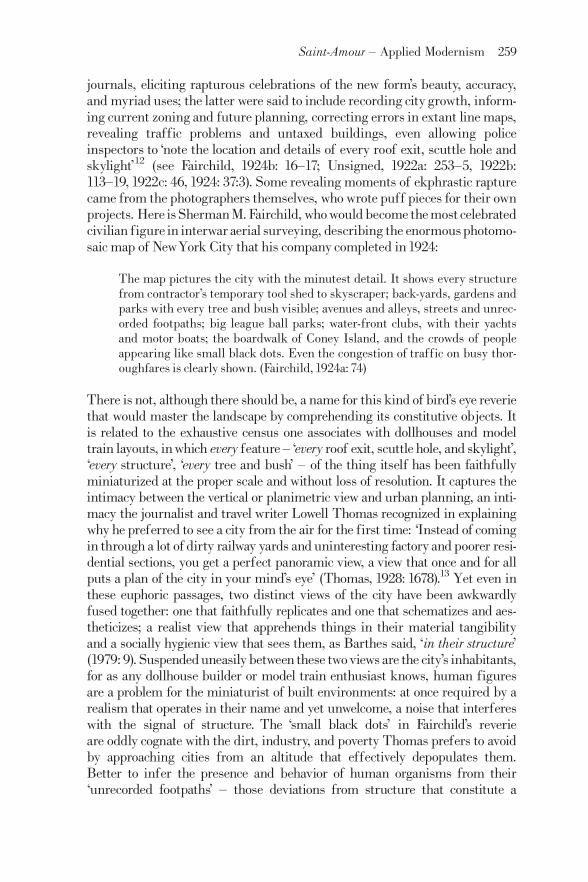
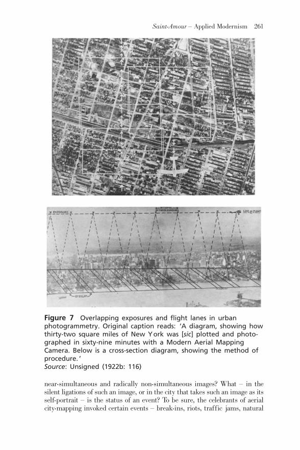
Figure 7 Overlapping exposures and flight lanes in urbanphotogrammetry. Original caption reads: ‘A diagram, showing howthirty-two square miles of New York was [sic] plotted and photo-graphed in sixty-nine minutes with a Modern Aerial MappingCamera. Below is a cross-section diagram, showing the method ofprocedure. ’Source: Unsigned (1922b: 116)
Saint-Amour ^ Applied Modernism 261

disasters and human-made emergencies ^ that photomosaics could help abateor prevent. In this, the proponents of 1920s aerial mapping as an urban plan-ning tool simply replicated the adversarial stance of wartime reconnaissance,which established abaseline of ‘condition’againstwhich tomeasure unwelcomeevents it would then eliminate or forestall. These nods to eventfulnessconstructed it as the exception that validated the rule, the rule in this casebeing the uneventful time of the unblemished grid.Yet despite this seeminglock-step between planimetric seeing and the timeless state of the condition,there remains in both the discourse and the practices of Fairchild et al. a capti-vation with events that cannot simply be adduced as proof of the aerialsurvey’s utility, events in excess of exception-that-proves-the-rule rhetoric.These are exceptions that prove no rule: workaday ones, such as the hangingout of a stranger’s laundry, or more momentous ones, such as the Carpentier^Dempsey championship fight, which a Fairchild plane photographed fromthe minimum legal altitude of 2000 feet over Boyle’s ThirtyAcres in JerseyCity on a rainy night in July1921. (The aerial coverage of the event allegedlybeat the ground photos into distribution [Unsigned, 1922b: 114, 117].)We might think of such glimpses, such stunts, as eventful flickers on theperiphery of the mosaic gaze, and as testimony that that gaze, for all its affini-ties with the general and the structural, was made entirely out of flickeringsof the particular.
Earlier I described as ‘applied modernism’ this flickering quality ofthe aerial photomosaic, with its patchwork temporality, its indelible disconti-nuities, and its subtle exposure of orthography as a conjuring trick thatsummons an impossible image from resistant pixels.The photomosaic testi-fied, in short, that seeing was a situated act: not a condition but an eventfulapprehension of events, along a sightline in relation to which other visibleobjects are perspectivally displaced. However we think of this particularmodernism ^ as a cunning assemblage of technologies, as an anti-Cartesiancorrelate of avant-garde painting, as a scopic regime of late modernity ^ wecan at least insist on its opposition to the schematizing modernism of, say,Le Corbusier, for whom, as for Lowell Thomas, the best way to see and toplan a city was from the air. Note, however, that the applied modernism ofthe photomosaic does not oppose the schematic and ^ let’s say it ^ totalizingmodernism of Le Corbusier and others from the ground, via some emphasison local performances and pedestrian enunciations that evade the all-seeingaerial eye.17 Irreducible to either the street-level practices of the fla“ neur orthe totalizing gaze of the planeur, the mosaic disrupts critical and spatialreflexes stabilized by the likes of Barthes and de Certeau ^ reflexes by whichwe project all authority, distance, and spatiality onto the universal verticalaxis and all resistance, locality, and temporality onto the horizontal.18
Instead, the photomosaic shows us how the always-situated optics of verticalseeing can reverse verticality’s misrecognition as the necessary axis of theplanner, the bomber, the sovereign. It asks us to consider what forms of dere-alization and coercion depend and thrive on horizontality.19 And it suggests,morebroadly, that an ethics of situatedperceptionmight oppose the totalizing
262 Theory, Culture & Society 28(7-8)
view fromnowherewithout ceding to that view, or to those viewers, theprojectof comprehensive portraiture.
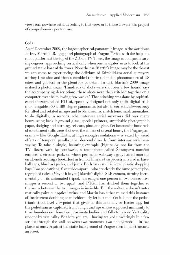
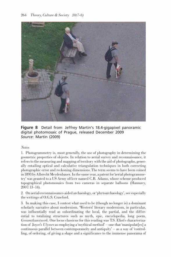
CodaAs of December 2009, the largest spherical-panoramic image in the world wasJeffrey Martin’s 18.4 gigapixel photograph of Prague.20 Shot with the help of arobot platform at the top of the Z› iz› kov TVTower, the image is oblique in vary-ing degrees, approaching vertical only when one navigates so as to look at theground at thebase of the tower. Nonetheless, Martin’s imagemaybe the closestwe can come to experiencing the delirium of Fairchild-era aerial surveyorsas they first shot and then assembled the first detailed photomosaics of UScities and got lost in the plenitude of detail. In fact, Martin’s 2009 imageis itself a photomosaic: ‘Hundreds of shots were shot over a few hours’, saysthe accompanying description; ‘these shots were then stitched together on acomputer over the following few weeks.’ That stitching was done by sophisti-cated software called PTGui, specially designed not only to fit digital stillsinto navigable 360�180-degree panoramas but also to correct automaticallyfor tilted and rotated images and to blend seams, match tone, mask anomalies:to do digitally, in seconds, what interwar aerial surveyors did over manyhours using backlit ground glass, special printers, stretchable photographicpaper, dodging and burning, scissors, pins, and glue.Yet because its hundredsof constituent stills were shot over the course of several hours, the Prague pan-orama ^ like Google Earth, at high enough resolutions ^ is vexed by weirdeffects of temporal parallax that descend directly from interwar aerial sur-veying. To take a single, haunting example (Figure 8): not far from theTV Tower, west by southwest, a roundabout called S› kroupovo na¤ me› st|¤encloses a circular park, on whose perimeter walkway a gray-haired man sitson abench readingabook. Just in frontof him are twopedestrians clad in base-ball caps, blue backpacks, and jeans. Both carry multicoloredplastic shoppingbags.Twopedestrians, five strides apart ^ who are clearly the samepersonpho-tographed twice. (Maybe it is you.) Martin’s digital SLRcamera, turning incre-mentally on its automated tripod, has caught one person in two consecutiveimages a second or two apart, and PTGui has stitched them together sothe seam between the two images is invisible. But the software doesn’t auto-matically paint out optical twins, and Martin has either missed this instanceof inadvertent doubling or mischievously let it stand.Yet it is not the pedes-trian’s street-level viewpoint that gives us this anomaly or Easter egg, butthe pedestrian as captured from a high vantage whose supposed immunity totime founders on those two proximate bodies and falls to pieces. Verticalityundone by verticality. So there you are ^ having walked unwittingly in a fewstrides through the wall between two moments, two photographs ^ in twoplaces at once. Against the static background of Prague seen in its structure,an event.
Saint-Amour ^ Applied Modernism 263
Notes1. Photogrammetry is, most generally, the use of photography in determining thegeometric properties of objects. In relation to aerial survey and reconnaissance, itrefers to themeasuring and mapping of territory with the aid of photographs, gener-ally entailing optical and calculative triangulation techniques in both correctingphotographic error and reckoning dimensions.The term seems to have been coinedin1893 byAlbrechtMeydenbauer. In the sameyear, apatent for‘aerial photogramme-try’ was granted to a US Army officer named C.B. Adams, whose scheme producedtopographical photomosaics from two cameras in separate balloons (Hannavy,2007:13^14).
2. On aerial-reconnaissance-aided archaeology, or ‘phytoarchaeology’, see especiallythe writings of O.G.S. Crawford.
3. In making this case, I contest what used to be (though no longer is) a dominantscholarly narrative about modernism. ‘Western’ literary modernism, in particular,was influentially read as subordinating the local, the partial, and the differ-ential to totalizing structures such as myth, epic, encyclopedia, long poem,Gesamtkunstwerk. One locus classicus for this reading was T.S. Eliot’s characteriza-tion of Joyce’sUlysses as employing a ‘mythical method’ ^ one that ‘manipulat[es] acontinuous parallel between contemporaneity and antiquity’ ^ as a way of ‘control-ling, of ordering, of giving a shape and a significance to the immense panorama of
Figure 8 Detail from Jeffrey Martin’s 18.4-gigapixel panoramicdigital photomosaic of Prague, released December 2009Source: Martin (2009)
264 Theory, Culture & Society 28(7-8)
futility and anarchywhich is contemporaryhistory’ (1975:177).The critical receptionof Anglophone literary modernism, at least, might have looked rather different hadEliot entertained thepossibility thatUlyssesdeploysHomer not to impose an ancientor ahistorical order on the chaotic present but to insist that the drive to imposeorder in such a manner is itself a historically, geographically, politically situatedone ^ that the total is, again, a special case or tendentious longing of the partial.Despite its brittle monologism, however, Eliot’s formulation does contain an insightpertinent to the present discussion: that the ‘immense panorama’, far frombeing an intrinsically ordered or intentional vantage, offers anarchy and futility tothe eye. Power, in other words, has to work to distil order or produce control from theIcarianview.
4. Our most influential analyst of the kill-chain is Paul Virilio, withwhose work myown is clearly in dialogue. Part of the polemical and formulative vigor of Virilio’swork stems from its willingness to extrapolate general, even total, maxims froman extreme example. For instance, Virilio has repeatedly invoked as ‘perfectlyexpress[ing] the new geostrategic situation and partially explain[ing] the currentround of disarmament’ a statement by former US Undersecretary of State forDefenseW.J. Perry: ‘Once you can see the target, you can expect to destroy it.’ ‘Ifwhat is perceived isalreadylost’, writesVirilio, ‘it becomes necessary to invest in con-cealment what used to be invested in simple exploitation of one’s available forces’(1989: 4, original emphasis). Virilio’s compression of Perry in paraphrasing him ^from ‘expect to destroy it’ to ‘already lost’ ^ exemplifies a widespread tendency inVirilio’s work to harden and shorten the kill-chain to the point where a whole criticalvision is based on a model of unerring, instantaneous targeting that continues to bebelied by the inaccuracy of actual military targeting. By exhibiting this faith in themost extreme military-accuracy claims,Virilio oddly forgoes the chance to engagewith the terrible consequences of their failure ^ with the disparity between, say, theideal of a precision target ‘already lost’ and the realities of ‘collateral damage’. Thisaspect of Virilio’s work provides a sharp example of how one finds abstract space inthe very theoretical sites where onemight most expect to find differential space. Fora more extended discussion of Virilio in relation to cognate work by SamuelWeber,Rey Chow, and Caren Kaplan, see Saint-Amour (2010).
5. Harold E. Porter marvels that:
From only 4,000 feet . . .with a 10-inch lens and a 4�5 plate, the longerside of the plate covers about 2,000 feet of ground, and the shorter sidecovers about 1,600 feet, with a total area of 450,000 square yards, or 175acres. At 7,000 feet [an altitude safely out of artillery range], the areashown is over 1,000,000 square yards. (1921:161^2)
6. Mydescription of the reconnaissance flights and subsequent photomosaic produc-tion is largely a paraphrase of Porter’s.
7. John Welchman, for instance, finds the RAF atlas’s citation of Cubism andFuturism‘quite remarkabl[e], given its origin in themilitaryestablishment of a coun-try many of whose few ‘‘advanced’’ cultural commentators were still fulminatingagainst the esthetic degeneracy of the continental avant-garde’ (1988:18).
8. I am indebted to Smith (1943: 52) for the notion that controlled mosaics effect atruce or ‘compromise’ (in Smith’s term) between perspectival and planimetric ororthographic projections.
Saint-Amour ^ Applied Modernism 265

9. For an excellent reading of the sovereign and biopolitical dimensions of RAFcolo-nial air surveys between the world wars, seeAdey (2010).
10. One Captain Bouche¤ of the French Service reportedly said:
Aerial photographs aremost valuable to show the present use of land, thedensity of population and the relation of open space to built over space.In the devastated regions they have been of the greatest help in makingsurveys, making it possible to study ensemble improvements, to reparcelproperty, to verify the lines of plans and to make bird’s-eye perspectivesof proposed improvements. (quoted in Hayler, 1920: 575^6)
11. The war, according to Brock and Holst’s fascinatingly resentful piece, had dis-tracted photogrammetry from its true concerns with mechanics and optics ^ withcamera automation, regular coverage, better shutters and lenses. In the meantime,they claim:
Our actual experimental work in photographic surveying and in thedesign of cameras to obtain these results has been carried far beyondexperimental work in this line by any individuals or by any of theGovernments who have participated in the EuropeanWar. (1919: 706)
Brock and Holst offer themselves, in effect, as an isolationist counterfactual tothe dominant narrative, which made peacetime aerial surveying a happy byproductof wartime research and development; in contrast, they represent the advancesaerial photogrammetry tout courtwould havemade had it not gone to war.Their arti-cle presses the counterfactual point farther, asking whether the current motion pic-ture industry would have reached its ‘present stage of [mechanical] perfection’ if it‘had had a military use and military development’.With the exception of developingnegatives and printing from them, airplane photography, they conclude, ‘is a matterwhich should be entirely in the hands of civil and mechanical engineers’ (1919: 707).
12. The piece is widely attributed to Fairchild but was published unsigned.
13. For a discussion of Thomas’s book in the context of 1920s aerial tourism, seeDeriu (2006).
14. Light offers a comprehensive account of Fairchild and other interwar aerial sur-veyors as an early incarnation of what she calls ‘moon-shot management forAmerican cities’ ^ a phrase that indexes the intersections between the ColdWarmili-tary-industrial-academic complex and urban planning during the same period.
15. Granted, the later map covered not just Manhattan but all five boroughs(Fairchild, 1924a: 74).
16. Whereas Fairchild’s signedJanuary1924 article inAmerican City omits mentionof the many obstacles to ‘suitable’ photographic mapping days, his longer, unsignedAviation piece from the same month goes into great detail on this count. For theurban planning readership of American City, the emphasis is on the clarity andinstantaneity of thephotogrammetric signal, as it were; for the airminded readershipofAviation, the emphasis falls on the aviator-photographer’s heroic agon with noise.My account of this noise is largely derived from the longer, unsigned piece.
17. On Le Corbusier and the aerial view, see Vidler (2000: 35^45) and Morshed(2002: 201^10).
266 Theory, Culture & Society 28(7-8)

18. I borrow the juxtaposition of fla“ neur and planeur from Deriu (2006), in whichthe latter term is resignified (planeurbeing French for ‘glider’) to denote urban plan-ners of the Le Corbusier type.
19. That horizontality can accommodate menacingly penetrating and centralizedscopic regimes has recently been demonstrated by the rash of complaints, lawsuits,and protests against Google Street View (GSV), whose latter-day fla“ nerie hasproven at least as controversial as the planimetric Google Earth. I’d suggest, addi-tionally, that the wide array of ludic and oppositional gestures GSV has attracted ^the websites where self-described ‘GSV voyeurs’ post screenshots of funny, glitchy,baffling, shocking, transgressive, illicit, and otherwise anomalous events serendipi-tously captured by the camera car; the performance art pieces staged for the sakeof the camera car by local residents to whom its shooting schedule was leaked inadvance ^ arise not because the horizontal is innately the plane of local resistance or(after de Certeau) pedestrian enunciations but because horizontality is emerging asthe site or mode par excellence of penetrative seeing ^ of what Google itself calls‘geoimmersive data production’ ^ and therefore attracts the most urgent and specta-cular counter-gestures.
20. The Prague image has since been surpassed in information-size by over a dozenpanoramic photographs, including a 26 -gigapixel image of Paris, a 45-gigapixelimage of Dubai, and a 272-gigapixel image of Shanghai ^ all of them replete withexamples of the ghosting and doubling I discuss here. Martin’s 80 -gigapixel imageof London is currently the largest spherical panoramic image in the world.
ReferencesAbrams, T. (1944) Essentials of Aerial Surveying and Photo Interpretation.NewYork: McGraw-Hill.Adey, P. (2010)Aerial Life: Spaces, Mobilities, Affects. Oxford:Wiley-Blackwell.Barthes, R. (1979) ‘The Eiffel Tower’, pp. 3^17 in The Eiffel Tower and OtherMythologies, trans. R. Howard. NewYork: Farrar, Straus, and Giroux.Brock, A. and L.J.R. Holst (1919) ‘The Future of Airplane Photography’, Aviation1 January: 705^7.De Certeau, M. (1984) The Practice of Everyday Life, trans. S. Rendall. Berkeley:University of California Press.Deriu, D. (2006) ‘TheAscent of the Modern Planeur: Aerial Images and the UrbanImaginary in the 1920s’, pp. 189^212 in C. Emden, C. Keen and D. Midgley (eds)Imagining the City,Vol.1:TheArt of Urban Living.Bern: Peter Lang AG.Eliot, T.S. (1975) Selected Prose of T.S. Eliot, edited by F. Kermode. New York:Harcourt Brace Jovanovich/Farrar, Straus, and Giroux.Fairchild Aerial Camera Corporation (1921)Aerial Survey, Manhattan Island, NewYork City. NewYork:The Corporation.Fairchild, S.M. (1922) ‘Winged Surveyors:What Aerial Photography Is Doing forIndustry and Science’, Scientific American126:157^60, 219.Fairchild, S.M. (1924a) ‘Aerial Mapping of NewYork City’,American City 30: 74^5.Fairchild, S.M. (1924b) ‘The Making of Greater NewYork’s Air Map’, Aviation 16:16^17.
Saint-Amour ^ Applied Modernism 267
Goddard, G.W. (1969) Overview: A Life-long Adventure in Aerial Photography.Garden City, NY: Doubleday.Hannavy, J. (2007)Encyclopedia ofNineteenth-centuryPhotography,Vol.1. London:Routledge.Hayler, G.W. (1920) ‘TheAeroplane and City Planning:TheAdvantages of ViewingCities from Above’,American City 23(6): 575^9.Ives, H.E. (1920)Airplane Photography. Philadelphia, PA: J.B. Lippincott.Lee, W.T. (1922) The Face of the Earth as Seen from the Air: A Study in theApplication of Airplane Photography to Geography. New York: AmericanGeographical Society.Lefebvre, H. (1991) The Production of Space, trans. D. Nicholson-Smith.Cambridge, MA: Blackwell.Lewis, N.P. (1922) ‘A NewAid in City Planning’,American City 26(3): 209^12.Light, J.S. (2003) From Warfare to Welfare: Defense Intellectuals and UrbanProblems in ColdWarAmerica. Baltimore, MD: Johns Hopkins University Press.Martin, J. (2009) 18.4 -gigapixel panoramic photo of Prague. URL (consultedFebruary 2011): http://www.360cities.net/prague-18 -gigapixels.Morshed, A. (2002) ‘The Cultural Politics of Aerial Vision: Le Corbusier in Brazil(1929)’, Journal of Architectural Education 55(4): 201^10.Porter,H.E. (1921)AerialObservation:TheAirplaneObserver, theBalloonObserver,and theArmyAir Corps Pilot. NewYork: Harper and Brothers.RAF (1918)Characteristics of the Ground and Landmarks in the Enemy Lines oppo-site the British Front from the Sea to St. Quentin. Branch Intelligence Section of theGHQWing.Saint-Amour, P.K. (2003) ‘Modernist Reconnaissance’, Modernism/Modernity 10:349^80.Saint-Amour, P.K. (2010) ‘War, Optics, Fiction’, NOVEL: A Forum on Fiction 43:93^9.Sekula, A. (1975) ‘The Instrumental Image: Steichen atWar’,Artforum14: 26^35.Smith, H.T.U. (1943) Aerial Photographs and Their Applications. New York:Appleton-Century-Crofts.Thomas, L. (1928) European Skyways:The Story of a Tour of Europe byAeroplane.London:William Heinemann.Unsigned (1922a) ‘Mosaic Maps of Cities’,American City 27(3): 253^5.Unsigned (1922b) ‘Practical Aerial Photography’,Photographic Journal ofAmerica59:113^19.Unsigned (1922c) ‘New York Mapped by Sky Camera in 69 Minutes!’, PopularScienceMonthly100: 46.Unsigned (1924) ‘Air Map of Greater City’,NewYork Times 30 September: 37, col. 3.Vidler, A. (2000) ‘Photourbanism: Planning the City from Above and Below’,pp. 35^45 in G. Bridge and S. Watson (eds) A Companion to the City. Oxford:Blackwell.Virilio, P. (1989)War and Cinema:The Logistics of Perception, trans. P. Camiller.London:Verso.
268 Theory, Culture & Society 28(7-8)

Welchman, J. (1988) ‘Here,There & Otherwise’,Artforum 27:16^19.Winchester,C. andF.L.Wills (1928)AerialPhotography:AComprehensive Surveyofits Practice and Development. London: Chapman and Hall.
PaulK. Saint-Amour isAssociateProfessor andGraduateChairofEnglish atthe University of Pennsylvania. His book, The Copywrights: IntellectualProperty and the Literary Imagination (2003), won the MLA Prize for a FirstBook and was followed by an edited volume, Modernism and Copyright(2010). He is the co-editor, with Jessica Berman, of the Modernist Latitudesbook series at Columbia University Press and, with Catherine Gallagher andMark Maslan, of a special ‘Counterfactuals’ issue of the journalRepresentations. He is currently finishing a book on total war, temporalityand interwar modernism. [email: [email protected]]
Saint-Amour ^ Applied Modernism 269